
Traffic Efficiency Models for Urban Traffic Management Using Mobile Crowd Sensing: A Survey

 ,
,  ,
,  ,
,  and
and
Abstract
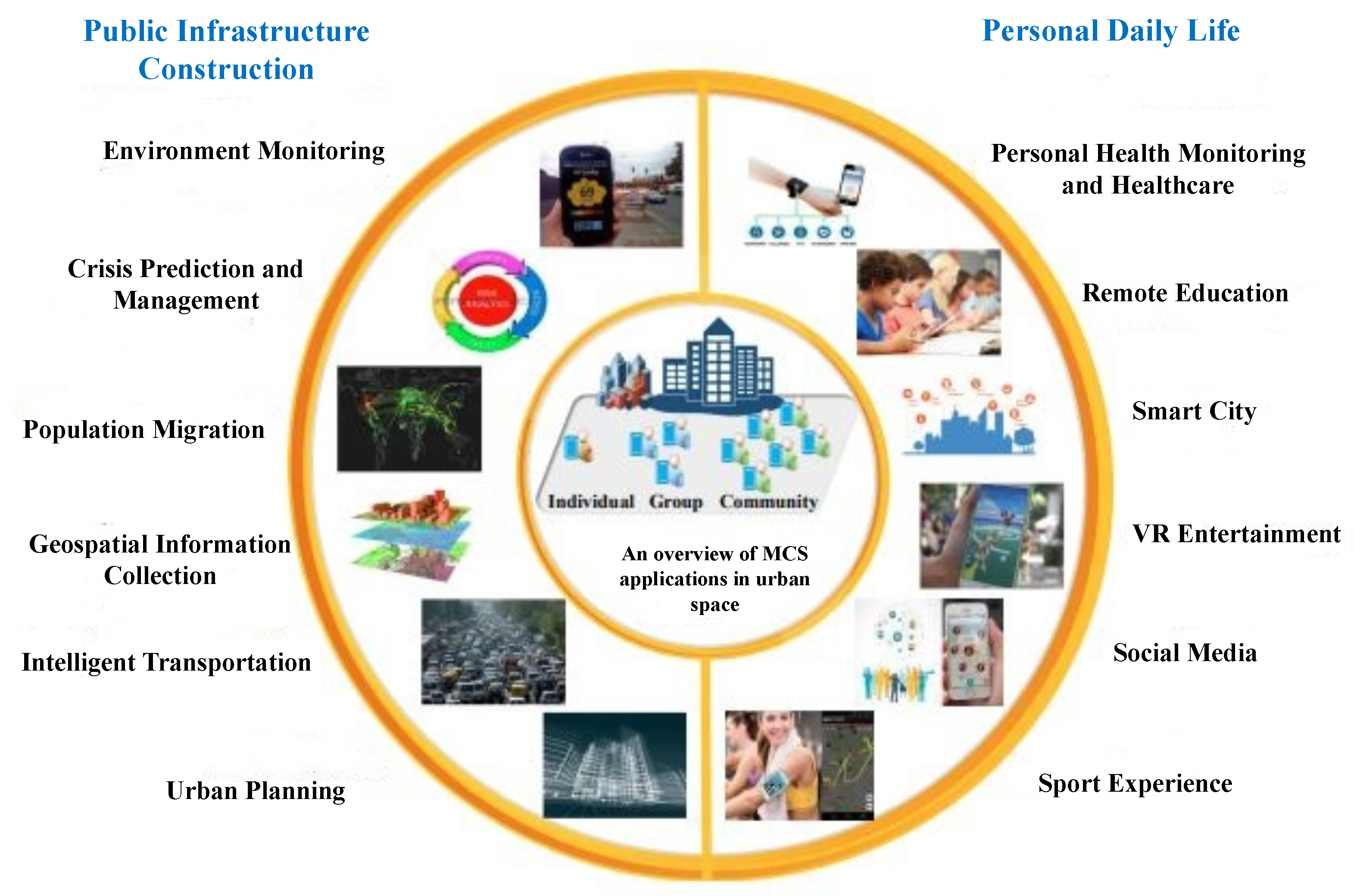
1. Introduction
- A realistic dynamic traffic efficiency model which collects the vehicular traffic data at a very low cost by using motorist smartphone.
- To collect data for analysis by using motorist smartphone or vehicular embedded Global Positioning System (GPS) without roadside sensors deployment and vehicle to vehicle communication.
- No need for network infrastructure deployment.
- Today’s urban traffic congestion is one of the main problems to be solved by such a traffic management scheme.
2. Background
2.1. Losses and Difficulties Occurrence Due to Traffic Congestion
2.2. Strategies for Reducing Urban Traffic Congestion
2.3. Basic Traffic Congestion Control Models in Transportation
3. Existing Traffic Congestion Control Models for Transport Systems
3.1. Related Projects of Traffic Management
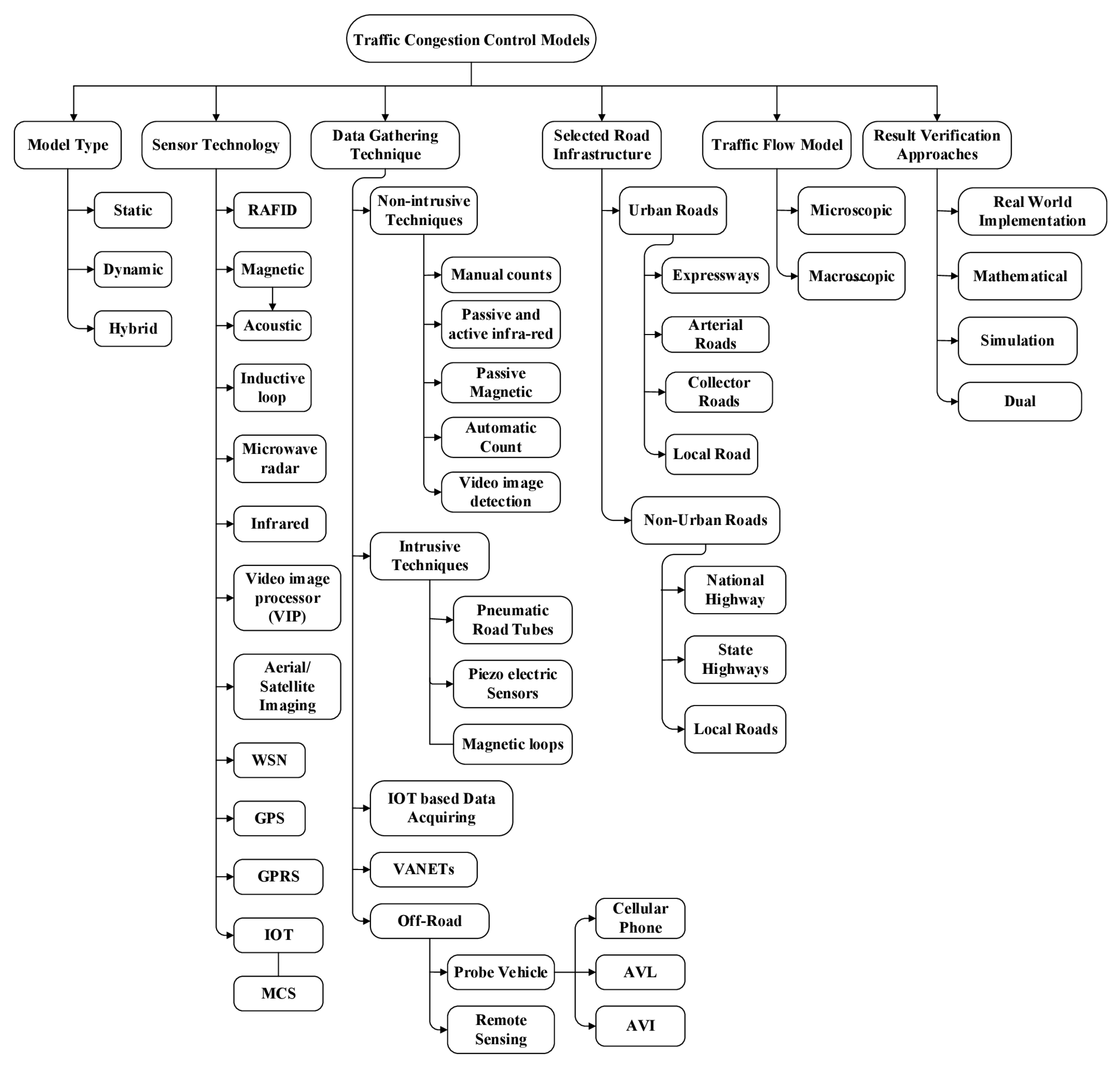
3.2. Thematic Taxonomy of TCCMs for Transport Systems
4. Comparison of TCCMs Using Thematic Taxonomy

| Study | Proposed Approach | Efficiency | Weakness |
|---|---|---|---|
| Shahi, G.S., et al. [41] | Proposes a mechanism called MRGM. This is a multi-metric traffic jam detection and avoidance mechanism for traffic conditions in urban areas. | This mechanism detects congestion and provides reroute the vehicle with the best route by setting a new route the path of the vehicle. | In this system, if congestion based on VCI which is the vehicle congestion index is found, then information is shared with other vehicles and RSU. |
| Gomides, T.S., et al. [42] | This work puts forward REACT, a traffic management solution that minimizes vehicle congestion in smart cities | Vehicles traveling on the requested road must respond to the requested displacement analysis. In the request-response phase, after considering the distributed database of road traffic conditions, the vehicle verifies alternatives and low-cost routes. | REACT is a traffic management system based on Vehicular communication. More motorist intervention required under this proposed system |
| Gomides, T.S., et al. [43] | In this model, the location of the roadblock is determined by the fuzzy logic system, and the system also focuses on finding the optimal membership limit to obtain better results. | In this model, the location of the roadblock is determined by the fuzzy logic system, and the system also focuses on finding the optimal membership limit to obtain better results. | Collect historical data from different traffic centers, collect the number of vehicles and vehicle speeds at every moment. |
| Ata, A., et al. [45] | Suggested MSR2C-ABPNN model for the intelligent transportation system for collecting traffic data from the controller | Proposed a neural network that uses fitting and time series models. Preprocess the received data from adjacent signal | In soft real-time systems such as intelligent transportation, time is of the essence. Therefore, if the data received by the signal sensor is delayed or too noisy, in this sense (MSR2C-ABPNN) Solution performance may be affected |
| KM Yousef, et al. [46] | A design for effective management and use of traffic light controllers to effectively control and manage traffic is proposed. | Simulation results show that the proposed traffic congestion solution is reasonable in terms of average waiting time and average queue length at a single intersection and effective global traffic flow control at multiple intersections. | The proposed solution is simulation-based |
| Rizwan et al. [47] | The STMS model is presented for the smart cities to update real-time traffic details for traffic management to avoid traffic congestion. | Traffic information provides to the user through the user interface like informing the user in a rush situation to follow an alternate route. To explore the traffic density of several places. | The proposed system is only for smart cities. IoT-based system. This system becomes costly due to magnetic devices attached to the vehicles and roadside embedded sensors. Costly due to more sensors deployments on the roads. |
| Sukode et al. [48] | A context-aware method for measuring real-time traffic status, traffic density, and measurement factors based on dynamic management of traffic signals to control traffic congestion. | Dynamically manage traffic signals observing the traffic density. | More user intervention required in this system. Costly due to requirements of more road side embedded sensors for traffic data gathering. |
| Al-Sakran et al. [49] | The proposed framework is based on the real-time traffic information implementation and monitoring architecture of the Internet of Things, RAFID, and WSN using wireless communication | Agent perform specific tasks without user intervention. The proposed system allows gathering real time traffic data generated by sensors. Multi agent system monitoring the traffic flow. A new way of monitoring traffic flow is provides through which improvement becomes in resource utilization and traffic conditions. | Interoperability between different standards, protocols, database systems, data formats, resource types, and heterogeneous hardware is the main problem of the Internet of Things. Storage space issue: vehicles related data will be saving in database, like vehicle number, drivers name and license number etc. Security issues. |
| Costea et al. [50] | Proposed architecture to monitor and collect real time traffic data to solve the problem of real time controlling and monitoring road vehicles to avoid traffic congestion. | Without any needful of a systematic human control the system has the capability to monitor a large number of locations. Low operating cost due to GPRS technology using. | Many sensors are required to sensed and collect outside environmental information |
| Lee, S [51] | The proposed scheme is for congestion detection and congestion avoidance in urban areas | Congestion detection and congestion avoidance in urban areas without the need for sensitive vehicle information, such as vehicle speed, vehicle location, and time. | Instead, a histogram model based on lightweight infrastructure is used to detect the degree of congestion in each lane. |
| Patni et al. [52] | A vehicle-to-vehicle (V2V)-based congestion detection system is proposed, in which traffic congestion is observed through the contribution of each vehicle. | VANETs collect real-time information of speed and position to improve signal on the intersection. | Its performance is not efficient for long-distance. Expensive due to RSU and infrastructure domain. |
| Susan Jan Pan et al. [53] | Presents a rerouting strategy named Distributed Vehicular Traffic Re-Routing System (DIVERT) is proposed. In the proposed system the vehicles exchanges their information over vehicular ad-hoc networks (VANETs). | It increases the user privacy substantially. The network and CPU load on server reduces through DIVERT system. This strategy protects the driver’s location secrecy. | The proposed decision-making process may be inaccurate because the vehicle calculates the alternate route separately. |
| Djahel et al. [54] | A solution based on vehicle-to-infrastructure communication technology to reduce road traffic congestion in smart cities, where traffic lights at road intersections communicate the traffic light cycle to approaching vehicles. | The Belief-Desire-Intention architecture models the vehicle’s reasoning and decision-making methods based on the local knowledge of the vehicle and the knowledge gained from surrounding vehicles and traffic light controllers (TLC) beacon via transmission. | Most actions are taken by the driver. The possibility of vehicles being selfish is in their actions. |
| El-Sayed et al. [55] | Proposed scheme to the congestion detection and congestion avoidance for urban areas without the requirements of vehicles sensitive information like the speed of the vehicle, location of vehicle and time. For congestion avoidance, the estimated shortest path first and re-routing strategy are used. | It forecasts the traffic congestion in advance and initiates the re-routing plan on time. | The scheme does not require the participation of vehicles. There is no real-time vehicles detection mechanism in the system. No participation of vehicles. |
| Study | Model Type | Technology(s) | Data Gathering Techniques | Road Infrastructure | Traffic Flow Model | Result Verification Approaches |
|---|---|---|---|---|---|---|
| [41] | Dynamic | Multi-metric traffic congestion detection and avoidance mechanism | vehicle congestion density function (VCD) | Urban local roads | Microscopic | Simulation |
| [42] | Static | REACT | Vehicle to vehicle and vehicle to infrastructure | Urban local roads | Microscopic | Simulation |
| [43] | Dynamic | Intelligent barricade system | Historical data | Urban local roads | Nil | Simulation |
| [45] | Static | Neural Network | Neural Network | Urban local roads | Nil | Real-world implementation |
| [46] | Static | WSN | WSN | Urban local roads | Microscopic | Simulation |
| [47] | Static | Inductive loop (Sensors Embedded) | IOT based data acquiring | Non-urban local road | Microscopic | Real-world implementation |
| [48] | Dynamic | Inductive loop (Sensors Embedded) | Piezoelectric sensors | Non- urban local road | Microscopic | Real-world implementation |
| [49] | Dynamic | RAFID +WSN +IOT+GPS | Piezoelectric sensors | Urban local road | Microscopic | Simulation |
| [50] | Static | GPRS | Piezoelectric sensors | Urban local road | Macroscopic | Simulation |
| [51] | Static | GSM/GPRS | GPS | Non-urban | Nill | Real-world implementation |
| [52] | Dynamic | VANETs | Probe vehicle | Urban road | Nill | Real-world implementation |
| [53] | Hybrid | VANETs /WLAN (Wi Fi, ZigBee) | Sensor equipped vehicles | Urban Roads | Microscopic | Simulation |
| [54] | Dynamic | V2I | Mobile/sensor equipped vehicles | Urban Roads | Microscopic | Simulation |
| [55] | Dynamic | VANETs | Non-intrusive | Urban roads | Microscopic | Simulation |
5. Analysis of Traffic Congestion Control Models
6. Open Issues and Research Challenges
6.1. Costly Techniques Used for Traffic Data Collection
6.2. Vehicle to Vehicles Communication in VANET
6.3. Data Collection Sensors Battery Life Timing/Energy Consumption
6.4. Cluster-Based Routing Protocol Issue in VANET
6.5. Needs More Motorist Intervention
7. Conclusions
Author Contributions
Funding
Institutional Review Board Statement
Informed Consent Statement
Data Availability Statement
Acknowledgments
Conflicts of Interest
References
- Joshi, Y.; Joshi, A.; Tayade, N.; Shinde, P.; Rokade, S.M. IoT Based Smart Traffic Density Alarming Indicator. Int. J. Adv. Comput. Sci. Appl. 2016, 03, 1086–1089. [Google Scholar]
- Dorrell, D.; Vinel, A.; Cao, D. Connected vehicles-advancements in vehicular technologies and informatics. IEEE Trans. Ind. Electron. 2015, 62, 7824–7826. [Google Scholar] [CrossRef]
- Morillon, J. Motor Vehicle Equipped with a Selective So-Called “HANDS-Free” Access System. U.S. Patent 6,621,178, 16 September 2003. [Google Scholar]
- Stopher, P.; FitzGerald, C.; Zhang, J. Search for a global positioning system device to measure person travel. Transp. Res. Part C Emerg. Technol. 2008, 16, 350–369. [Google Scholar] [CrossRef]
- Lee, S.-S.; Kim, Y.-S. Device for Data Communications between Wireless Application Protocol Terminal and Wireless Application Server, and Method Thereof. U.S. Patent 6,937,604, 30 August 2005. [Google Scholar]
- Miorandi, D. Internet of things: Vision, applications and research challenges. Ad Hoc Netw. 2012, 10, 1497–1516. [Google Scholar] [CrossRef]
- Choking Life: 12 on Way to Hospitals Die in Traffic Jams. Available online: https://timesofindia.indiatimes.com/city/raipur/choking-life-12-on-way-to-hospitals-die-in-traffic-jams/articleshow/54910538.cms (accessed on 29 July 2021).
- Stojanovic, D.; Predic, B.; Stojanovic, N. Mobile crowd sensing for smart urban mobility. Eur. Handbook Crowd. Geogr. Infor. 2016, 1, 371–382. [Google Scholar]
- Talasila, M.; Curtmola, R.; Borcea, C. Alien vs. Mobile user game: Fast and efficient area coverage in crowdsensing. in Mobile Computing, Applications and Services (MobiCASE). In Proceedings of the 6th International Conference on Mobile Computing, Applications and Services, Austin, TX, USA, 6–7 November 2014. [Google Scholar]
- Chatzimilioudis, G.; Konstantinidis, A.; Laoudias, C.; Zeinalipour-Yazti, D. Crowdsourcing with smartphones. IEEE Int. Comput. 2012, 16, 36–44. [Google Scholar] [CrossRef]
- Wan, J.; Liu, J.; Shao, Z.; Vasilakos, A.V.; Imran, M.; Zhou, K. Mobile crowd sensing for traffic prediction in internet of vehicles. Sensors 2016, 16, 88. [Google Scholar] [CrossRef]
- Arora, R.; Gautam, A.; Sahni, S. Global positioning system. Int. J. Comput. Trends Technol. 2017, 46, 80–83. [Google Scholar] [CrossRef][Green Version]
- Yi, W.-J.; Jia, W.; Saniie, J. Mobile sensor data collector using Android smartphone. In Proceedings of the 2012 IEEE 55th International Midwest Symposium on Circuits and Systems (MWSCAS), Boise, ID, USA, 5–8 August 2012; pp. 956–959. [Google Scholar]
- Ganti, R.K.; Ye, F.; Lei, H. Mobile crowdsensing: Current state and future challenges. IEEE Commun. Mag. 2011, 49, 32–39. [Google Scholar] [CrossRef]
- Stenneth, L.; Wolfson, O.; Yu, P.S.; Xu, B. Transportation mode detection using mobile phones and GIS information. In Proceedings of the 19th ACM SIGSPATIAL International Conference on Advances in Geographic Information Systems, Chicago, IL, USA, 1–4 November 2011; pp. 54–63. [Google Scholar]
- Li, W.; Nie, D.; Wilkie, D.; Lin, M.C. Citywide estimation of traffic dynamics via sparse GPS traces. IEEE Intell. Transp. Syst. Mag. 2017, 9, 100–113. [Google Scholar] [CrossRef]
- Sankaran, J.K.; Gore, A.; Coldwell, B. The impact of road traffic congestion on supply chains: Insights from Auckland, New Zealand. Int. J. Logist. Res. Appl. 2005, 8, 159–180. [Google Scholar] [CrossRef]
- Shu, L.; Chen, Y.; Huo, Z.; Bergmann, N.; Wang, L. When mobile crowd sensing meets traditional industry. IEEE Access 2017, 5, 15300–15307. [Google Scholar] [CrossRef]
- Pankratius, V.; Lind, F.; Coster, A.; Erickson, P.; Semeter, J. Mobile crowd sensing in space weather monitoring: The mahali project. IEEE Commun. Mag. 2014, 52, 22–28. [Google Scholar] [CrossRef]
- Dobra, A.; Williams, N.E.; Eagle, N. Spatiotemporal detection of unusual human population behavior using mobile phone data. PLoS ONE 2015, 10, e0120449. [Google Scholar] [CrossRef] [PubMed]
- Tamilin, A.; Carreras, I.; Ssebaggala, E.; Opira, A.; Conci, N. Context-aware mobile crowdsourcing. In Proceedings of the 2012 ACM Conference on Ubiquitous Computing, Pittsburgh, PA, USA, 5–8 September 2012; pp. 717–720. [Google Scholar]
- Cardone, G.; Cirri, A.; Corradi, A.; Foschini, L. The participact mobile crowd sensing living lab: The testbed for smart cities. IEEE Commun. Mag. 2014, 52, 78–85. [Google Scholar] [CrossRef]
- Ren, J.; Zhang, Y.; Zhang, K.; Shen, X. Exploiting mobile crowdsourcing for pervasive cloud services: Challenges and solutions. IEEE Commun. Mag. 2015, 53, 98–105. [Google Scholar] [CrossRef]
- Pantelopoulos, A.; Bourbakis, N.G. A survey on wearable sensor-based systems for health monitoring and prognosis. IEEE Trans. Syst. Man Cyber. Part C (Appl. Rev.) 2009, 40, 1–12. [Google Scholar] [CrossRef]
- Bochicchio, M.A.; Zappatore, M.; Longo, A. Using Mobile Crowd Sensing to teach technology and entrepreneurship in high schools: An experience from Southern Italy. In Proceedings of the 2015 IEEE Global Engineering Education Conference (EDUCON), Tallinn, Estonia, 18–20 March 2015; pp. 948–953. [Google Scholar]
- Mardenfeld, S.; Boston, D.; Pan, S.J.; Jones, Q.; Iamntichi, A.; Borcea, C. Gdc: Group discovery using co-location traces. In Proceedings of the 2010 IEEE Second International Conference on Social Computing, Minneapolis, MN, USA, 20–22 August 2010; pp. 641–648. [Google Scholar]
- Commuters in Most Congested Towns and Cities Waste Five Days a Year in Traffic. Available online: https://cityscapeltd.com/news/commuters-in-most-congested-towns-and-cities-waste-five-days-a-year-in-traffic/ (accessed on 2 June 2021).
- Sharma, N.; Kumar, P.V.P.; Singh, A.; Dhyani, R. Fuel loss and related emissions due to idling of motorized vehicles at a major intersection in Delhi. In Environmental Pollution; Springer: Singapore, 2018; pp. 233–241. [Google Scholar]
- Legrain, A.; Eluru, N.; El-Geneidy, A.M. Am stressed, must travel: The relationship between mode choice and commuting stress. Transp. Res. Part F Traffic Psychol. Behav. 2015, 34, 141–151. [Google Scholar] [CrossRef]
- Barth, M.; Boriboonsomsin, K. Real-world carbon dioxide impacts of traffic congestion. Transp. Res. Rec. 2008, 2058, 163–171. [Google Scholar] [CrossRef]
- Kim, K.E.; Cho, D.; Park, H.J. Air pollution and skin diseases: Adverse effects of airborne particulate matter on various skin diseases. Life Sci. 2016, 152, 126–134. [Google Scholar] [CrossRef]
- Zhang, S.; Wu, Y.; Liu, H.; Huang, R.; Yang, L.; Li, Z.; Fu, L.; Hao, J. Real-world fuel consumption and CO2 emissions of urban public buses in Beijing. Appl. Energy 2014, 113, 1645–1655. [Google Scholar] [CrossRef]
- Ban, X.J.; Kamga, C.; Wang, X.; Wojtowicz, J.; Klepadlo, E.; Sun, Z.; Mouskos, K. Adaptive Traffic Signal Control System (ACS-Lite) for Wolf Road, Albany, New York; Final Report; Department of Transportation: New York, NY, USA, 2014.
- Gopalakrishna, D.; Cluett, C.; Kitchener, F.; Balke, K. Developments in Weather Responsive Traffic Management Strategies; No. FHWA-JPO-11-086; United States Joint Program Office for Intelligent Transportation Systems: Washington, DC, USA, 2011.
- Modelling-Controlling-Traffic-Congestion. Available online: https://www.epfl.ch/research/domains/transportation-center/modelling-controlling-traffic-congestion/ (accessed on 3 June 2021).
- Multi-Modal Traffic Management Schemes for the City of Geneva. Available online: https://www.epfl.ch/research/domains/transportation-center/research-overview/mobility-analysis-social-behavior/traffic-management/traffic-management-geneva/ (accessed on 3 June 2021).
- Bennett, C.R.; Solminihac, H.D.; Chamorro, A. Data Collection Technologies for Road Management. 2006. Available online: https://openknowledge.worldbank.org/handle/10986/11776 (accessed on 3 July 2021).
- Leduc, G. Road traffic data: Collection methods and applications. Work. Pap. Energy Transp. Clim. Chang. 2008, 1, 1–55. [Google Scholar]
- Qureshi, M.A.; Noor, R.M.; Shamshirband, S.; Parveen, S.; Shiraz, M.; Gani, A. A survey on obstacle modeling patterns in radio propagation models for vehicular ad hoc networks. Arabian J. Sci. Eng. 2015, 40, 1385–1407. [Google Scholar] [CrossRef]
- Zheng, J.; Wang, Q.; Xu, B.; Bi, W.; Tao, Y.; Xiao, Y.; Ozdemir, S. Non-intrusive Traffic Data Collection with Wireless Sensor Networks for Intelligent Transportation Systems. Adhoc Sens. Wirel. Netw. 2016, 34, 41–57. [Google Scholar]
- Shahi, G.S.; Batth, R.S.; Egerton, S. MRGM: An adaptive mechanism for congestion control in smart vehicular network. Int. J. Commun. Netw. Inf. Secur. 2020, 12, 273–280. [Google Scholar]
- Gomides, T.S. A Traffic Management System to Minimize Vehicle Congestion in Smart Cities. In Proceedings of the 2020 IEEE International Conference on Systems, Man, and Cybernetics (SMC), Toronto, ON, Canada, 11–14 October 2020. [Google Scholar]
- Raskar, C.; Nema, S. Modified fuzzy-based smart barricade movement for traffic management system. Wirel. Personal Commun. 2021, 116, 3351–3370. [Google Scholar] [CrossRef]
- Niu, X.; Huang, H.; Li, Y. A real-time data collection mechanism with trajectory privacy in mobile crowd-sensing. IEEE Commun. Lett. 2020, 24, 2114–2118. [Google Scholar] [CrossRef]
- Ata, A.; Khan, M.A.; Abbas, S.; Ahmad, G.; Fatima, A. Modelling smart road traffic congestion control system using machine learning techniques. Neural Netw. World 2019, 29, 99–110. [Google Scholar] [CrossRef]
- Yousef, K.M.; Al-Karaki, M.N.; Shatnawi, A.M. Intelligent traffic light flow control system using wireless sensors networks. J. Inf. Sci. Eng. 2010, 26, 753–768. [Google Scholar]
- Rizwan, P.; Suresh, K.; Babu, M.R. Real-time smart traffic management system for smart cities by using Internet of Things and big data. In Proceedings of the 2016 International Conference on Emerging Technological Trends (ICETT), Kollam, India, 21–22 October 2016; pp. 1–7. [Google Scholar]
- Sukode, S.; Gite, S. Vehicle traffic congestion control & monitoring system in IoT. Int. J. Appl. Eng. Res. 2015, 10, 19513–19523. [Google Scholar]
- Al-Sakran, H.O. Intelligent traffic information system based on integration of Internet of Things and Agent technology. Int. J. Adv. Comput. Sci. Appl. (IJACSA) 2015, 6, 37–43. [Google Scholar]
- Costea, I.M.; Nemtanu, F.C.; Dumitrescu, C.; Banu, C.V.; Banu, G.S. Monitoring system with applications in road transport. In Proceedings of the 2014 IEEE 20th International Symposium for Design and Technology in Electronic Packaging (SIITME), Bucharest, Romania, 23–26 October 2014; pp. 145–148. [Google Scholar]
- Lee, S.; Tewolde, G.; Kwon, J. Design and implementation of vehicle tracking system using GPS/GSM/GPRS technology and smartphone application. In Proceedings of the 2014 IEEE World Forum on Internet of Things (WF-IoT), Seoul, Korea, 6–8 March 2014; pp. 353–358. [Google Scholar]
- Patni, R.; Jain, G. A Survey of Traffic Congestion Detection and Management Technique using VANET. Int. J. Emerg. Technol. Innovat. Res. 2015, 2, 53–58. [Google Scholar]
- Pan, J.; Popa, I.S.; Borcea, C. Divert: A distributed vehicular traffic re-routing system for congestion avoidance. IEEE Trans. Mob. Comput. 2016, 16, 58–72. [Google Scholar] [CrossRef]
- Djahel, S.; Jabeur, N.; Barrett, R.; Murphy, J. Toward V2I communication technology-based solution for reducing road traffic congestion in smart cities. In Proceedings of the 2015 International Symposium on Networks, Computers and Communications (ISNCC), Yasmine Hammamet, Tunisia, 13–15 May 2015; pp. 1–6. [Google Scholar]
- El-Sayed, H.; Thandavarayan, G.; Sankar, S.; Mahmood, I. An infrastructure based congestion detection and avoidance scheme for VANETs. In Proceedings of the 2017 13th International Wireless Communications and Mobile Computing Conference (IWCMC), Valencia, Spain, 26–30 June 2017; pp. 1035–1040. [Google Scholar]
- Nellore, K.; Hancke, G.P. A survey on urban traffic management system using wireless sensor networks. Sensors 2016, 16, 157. [Google Scholar] [CrossRef] [PubMed]
- Conti, M.; Giordano, S. Mobile ad hoc networking: Milestones, challenges, and new research directions. IEEE Commun. Mag. 2014, 52, 85–96. [Google Scholar] [CrossRef]
- Tønnesen, A. Mobile Ad-Hoc Networks. Available online: http://www.olsr.org/docs/wos3-olsr.pdf (accessed on 5 July 2021).
- Engoulou, R.G.; Bellaïche, M.; Pierre, S.; Quintero, A. VANET security surveys. Comput. Commun. 2014, 44, 1–13. [Google Scholar] [CrossRef]
- Singh, S.; Agrawal, S. VANET routing protocols: Issues and challenges. In Proceedings of the 2014 Recent Advances in Engineering and Computational Sciences (RAECS), Chandigarh, India, 6–8 March 2014; pp. 1–5. [Google Scholar]
- Ali, A.; Qureshi, M.A.; Shiraz, M.; Shamim, A. Mobile crowd sensing based dynamic traffic efficiency framework for urban traffic congestion control. Sustain. Comput. Inf. Syst. 2021, 32, 100608. [Google Scholar] [CrossRef]


| Project Name | Year of Start-Completion | Project Supporter | Project Objectives |
|---|---|---|---|
| Adaptive Traffic Signal Control System (ACS Lite) for wolf road, NY | 2012–2013 | NY State Department of Transportation | Dynamically adjust signal timing according to the situation to meet current traffic flow requirements |
| Advanced Weather Responsive Traffic Management Strategies | 2012–2013 | U.S. Research and Innovation Technology Administration | Road weather management was the main objective of this project |
| Modeling and controlling traffic congestion | 2012–2017 | European Research Council | Model and optimize large and congested road networks through comprehensive and realistic traffic dynamics and route selection for multiple modes of transportation |
| Multimodal traffic management schemes for the city of Geneva | 2014–2015 | Direction générale des transports Etat de Genève | Study the feasibility of large-scale cooperative multi-mode intelligent traffic management solutions and evaluate current traffic management strategies |
Publisher’s Note: MDPI stays neutral with regard to jurisdictional claims in published maps and institutional affiliations. |
© 2021 by the authors. Licensee MDPI, Basel, Switzerland. This article is an open access article distributed under the terms and conditions of the Creative Commons Attribution (CC BY) license (https://creativecommons.org/licenses/by/4.0/).
Share and Cite
Ali, A.; Ayub, N.; Shiraz, M.; Ullah, N.; Gani, A.; Qureshi, M.A. Traffic Efficiency Models for Urban Traffic Management Using Mobile Crowd Sensing: A Survey. Sustainability 2021, 13, 13068. https://doi.org/10.3390/su132313068
Ali A, Ayub N, Shiraz M, Ullah N, Gani A, Qureshi MA. Traffic Efficiency Models for Urban Traffic Management Using Mobile Crowd Sensing: A Survey. Sustainability. 2021; 13(23):13068. https://doi.org/10.3390/su132313068
Chicago/Turabian StyleAli, Akbar, Nasir Ayub, Muhammad Shiraz, Niamat Ullah, Abdullah Gani, and Muhammad Ahsan Qureshi. 2021. "Traffic Efficiency Models for Urban Traffic Management Using Mobile Crowd Sensing: A Survey" Sustainability 13, no. 23: 13068. https://doi.org/10.3390/su132313068
APA StyleAli, A., Ayub, N., Shiraz, M., Ullah, N., Gani, A., & Qureshi, M. A. (2021). Traffic Efficiency Models for Urban Traffic Management Using Mobile Crowd Sensing: A Survey. Sustainability, 13(23), 13068. https://doi.org/10.3390/su132313068