
Farmers’ Awareness in the Context of Climate Change: An Underutilized Way for Ensuring Sustainable Farmland Adaptation and Surface Water Quality

 ,
, 
 ,
,  ,
,  ,
, 
Abstract
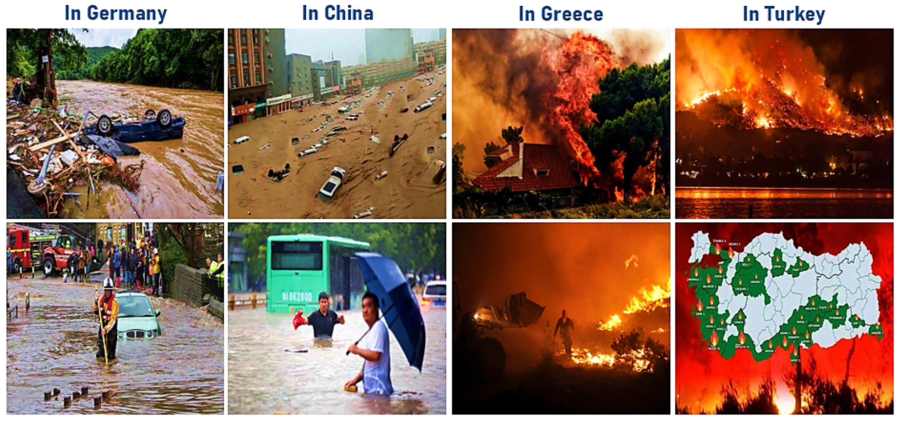
:1. Introduction
- Assess the role of SSC (as a simple physical approach that is easily managed and adjusted by farmers) in mitigating the projected climate change’s adverse impacts on paddy lands’ water balance at the lower reaches of the Yangtze River basin;
- Assess how such adaptation affects the future irrigation requirements in the study area.
- Project future (2026–2045) climate changes in the study area;
- Estimate future rainwater losses and irrigation requirements corresponding to the projected climate changes by applying the CROPWAT model;
- Re-run CROPWAT simulations under higher SSC conditions (50% and 100% higher than the baseline value) to assess the influence of SSC changes on future runoff losses and irrigation requirements.
2. Materials and Methods
2.1. Study Area
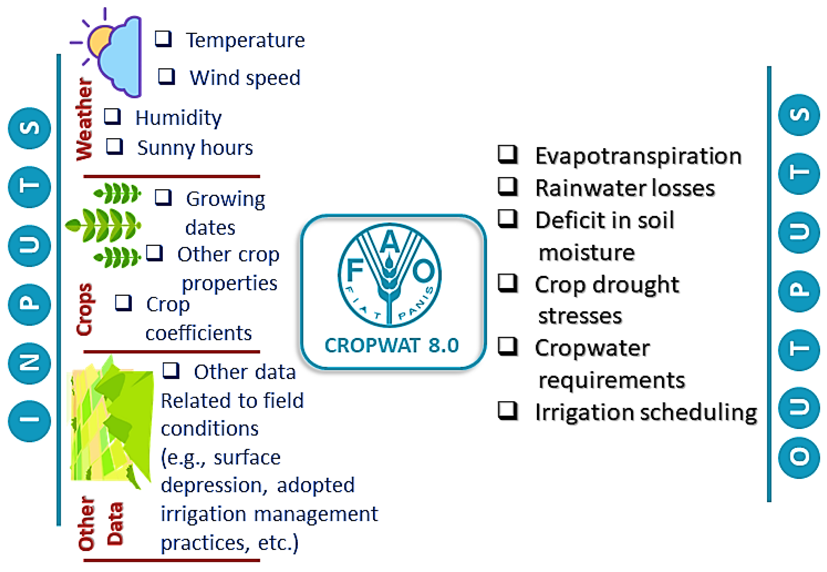
2.2. CROPWAT Model
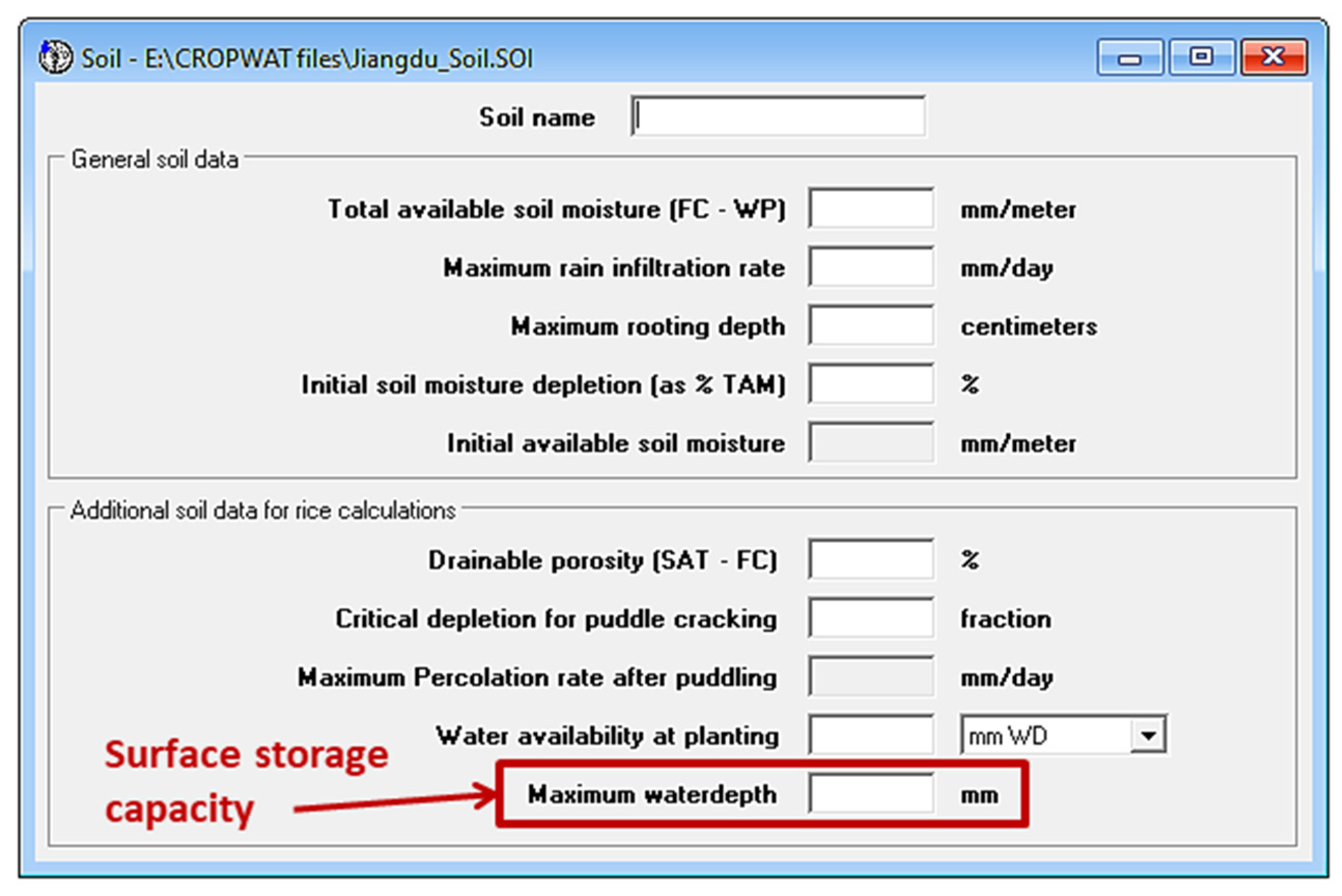
Surface Storage Capacity in the CROPWAT Model
- 50% higher future surface storage capacity than the current one
- 100% higher future surface storage capacity than the current one
2.3. Collection of Data Required to Set up and Run the CROPWAT Model
2.3.1. Weather Data
- Baseline weather data: These data were used, alongside the other historical weather data, as a reference for comparing to future weather projections to assess the projected climate changes in the study area.
- Future weather data: These data were used as input in the CROPWAT model to estimate the future irrigation requirements of the rice-growing season in the study area.
2.3.2. Soil and Crop Data
3. Results and Discussion
3.1. Future Climate Pattern in the Study Area
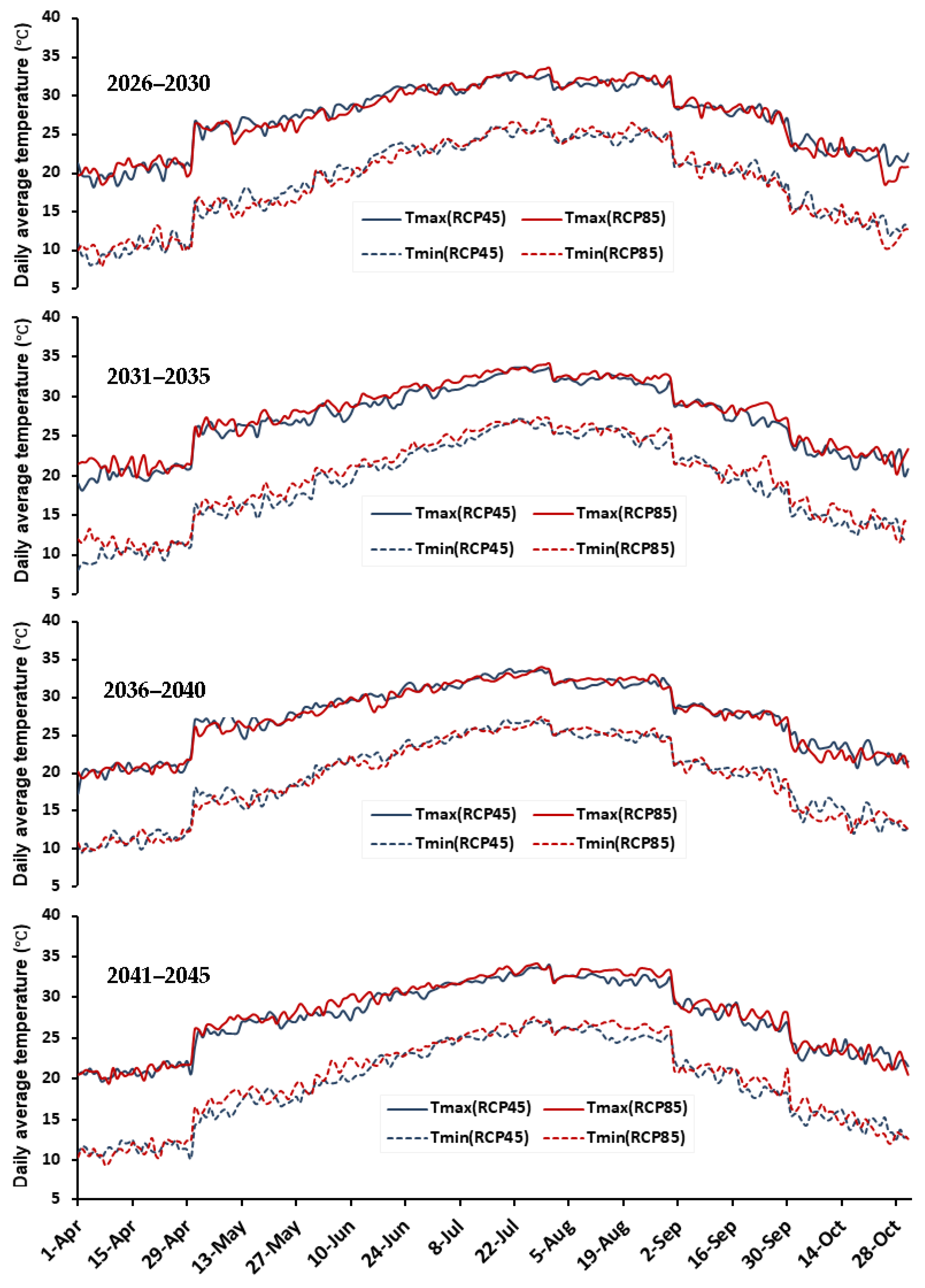
3.1.1. Daily Maximum and Minimum Temperatures
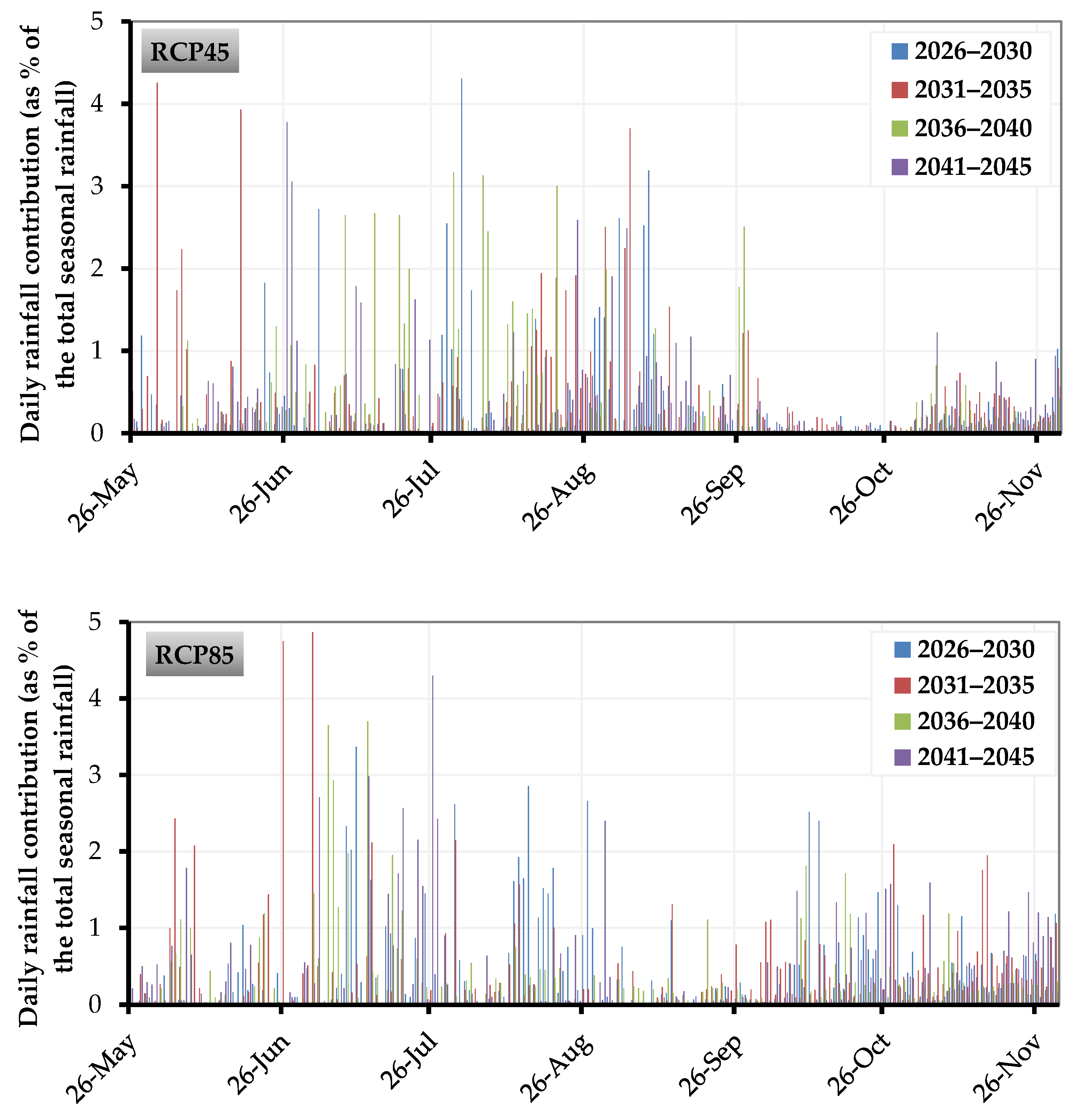
3.1.2. Precipitation
3.2. CROPWAT Simulations
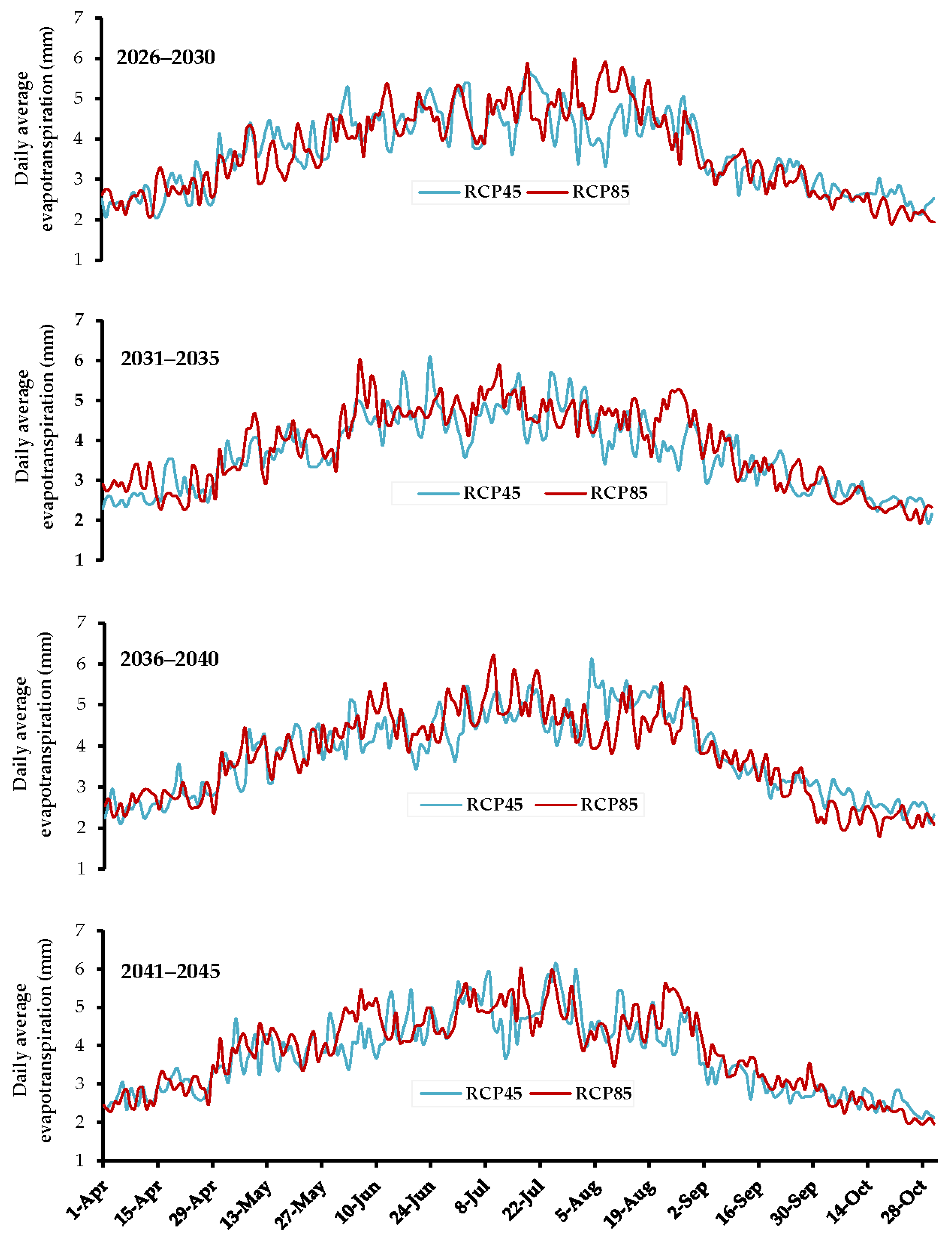
3.2.1. CROPWAT Estimates for Future Daily Evapotranspiration
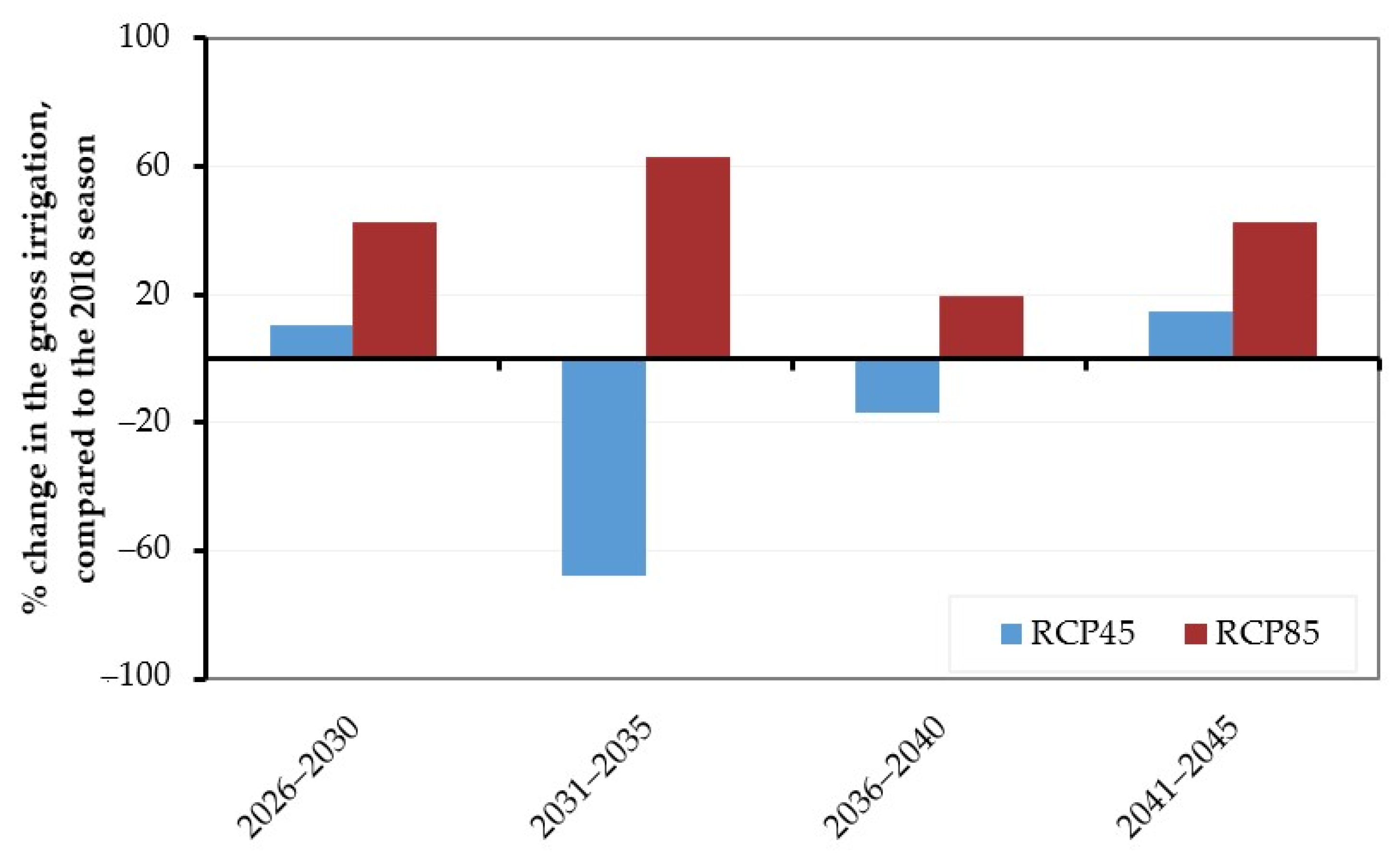
3.2.2. CROPWAT Estimates for Future Irrigation Requirements
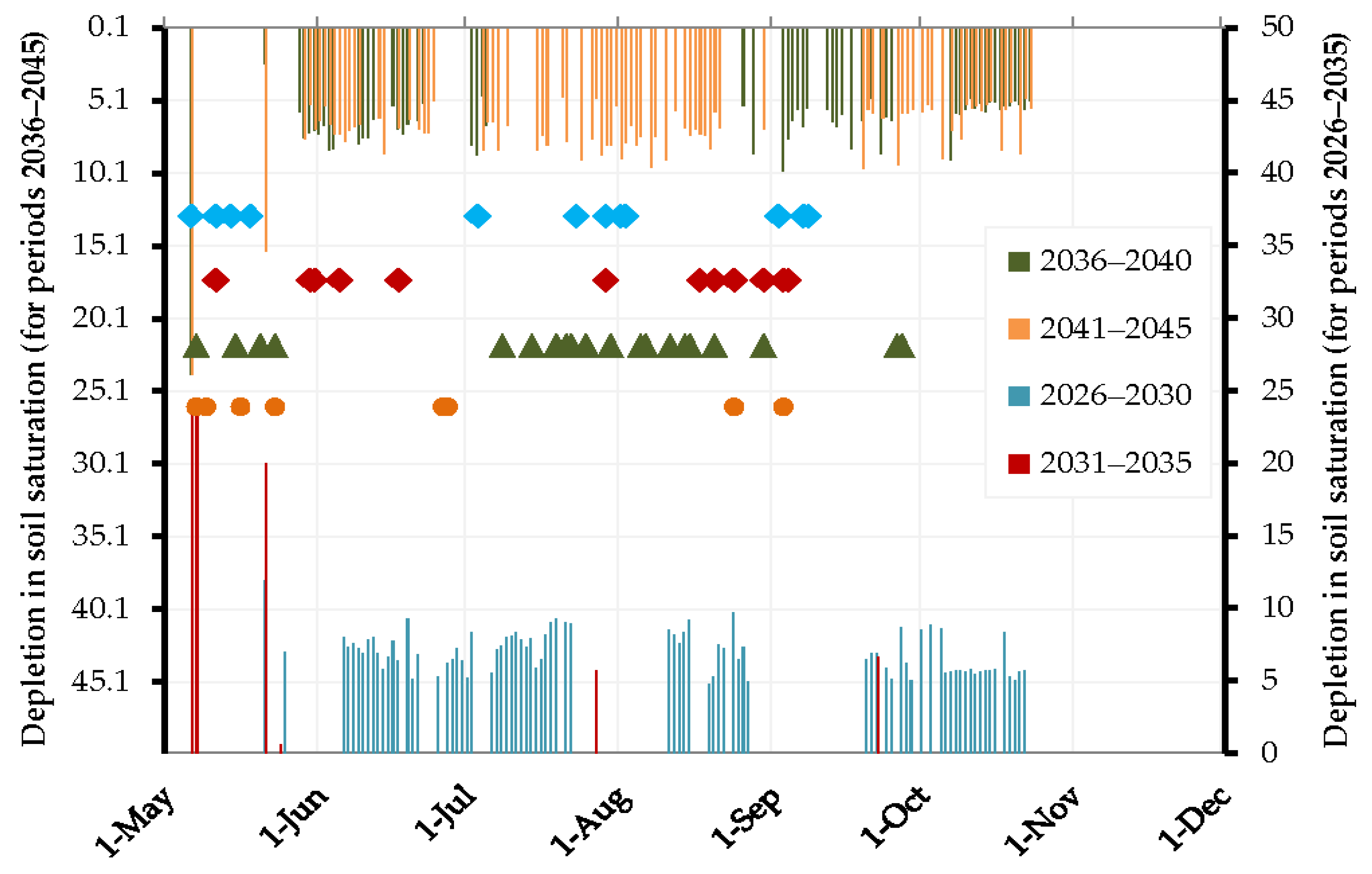
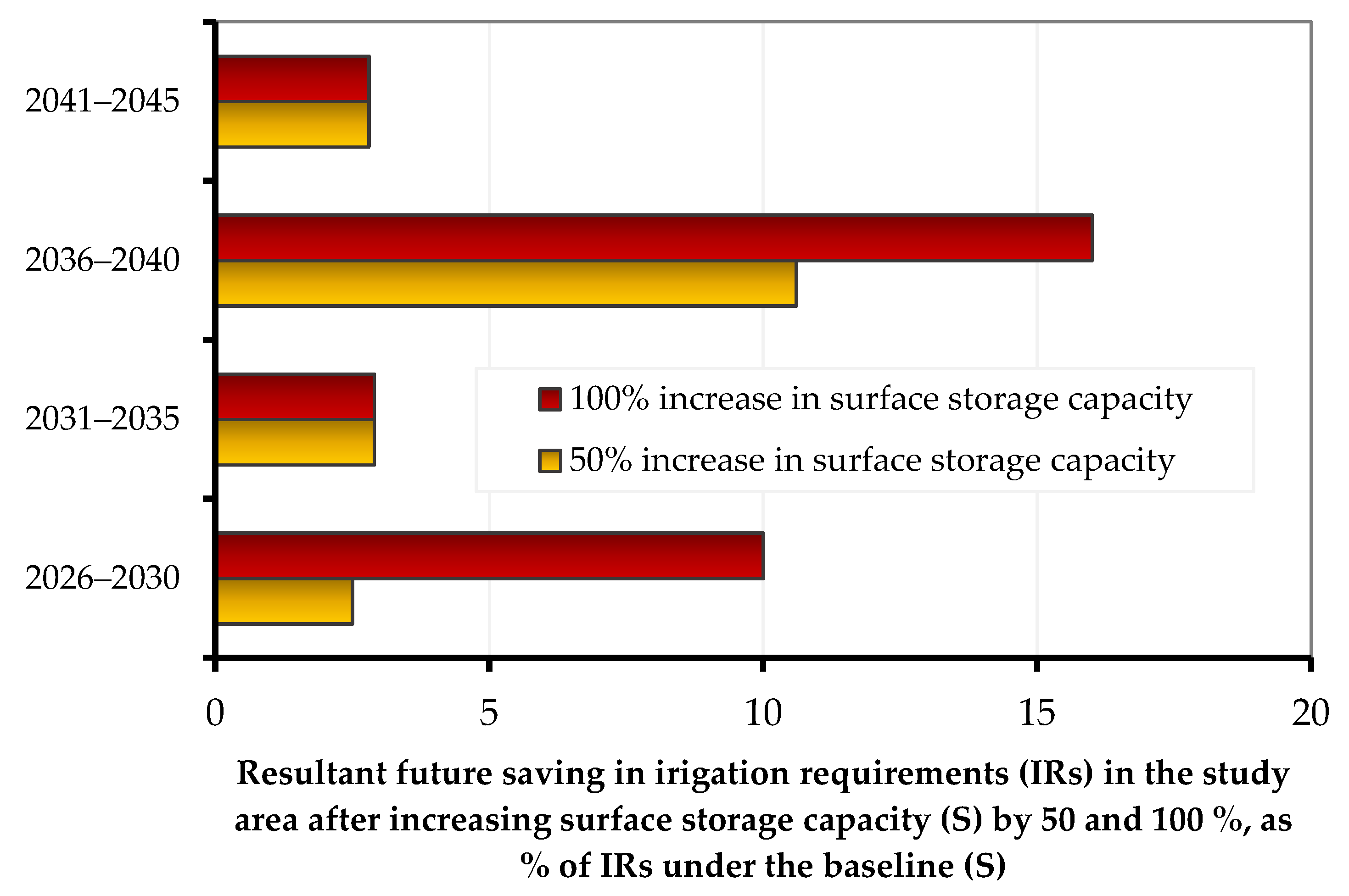
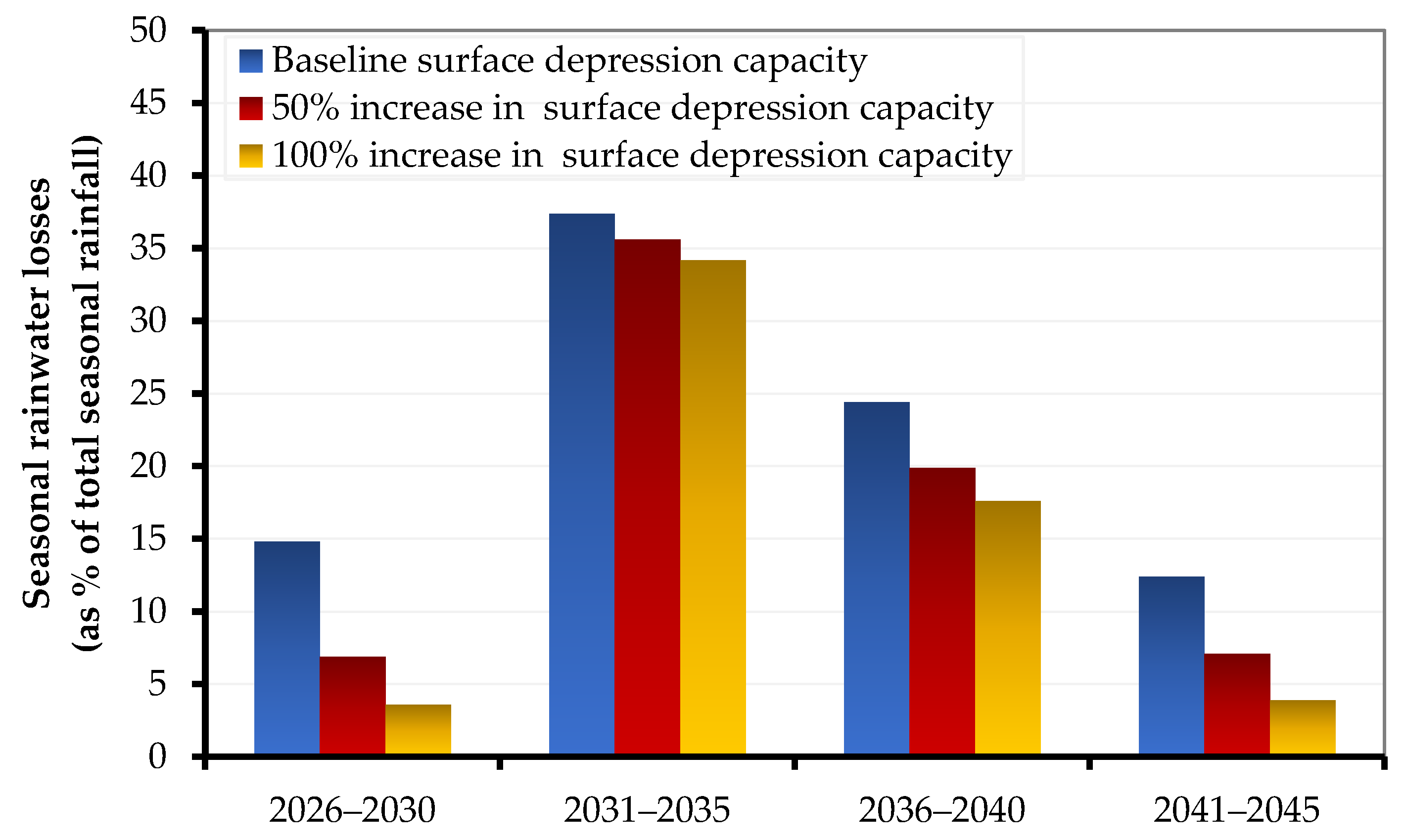
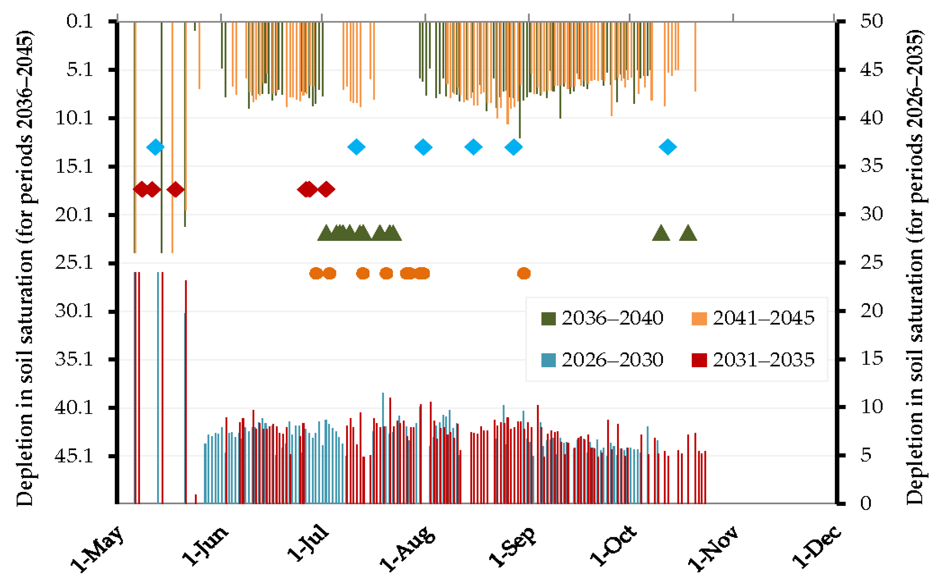
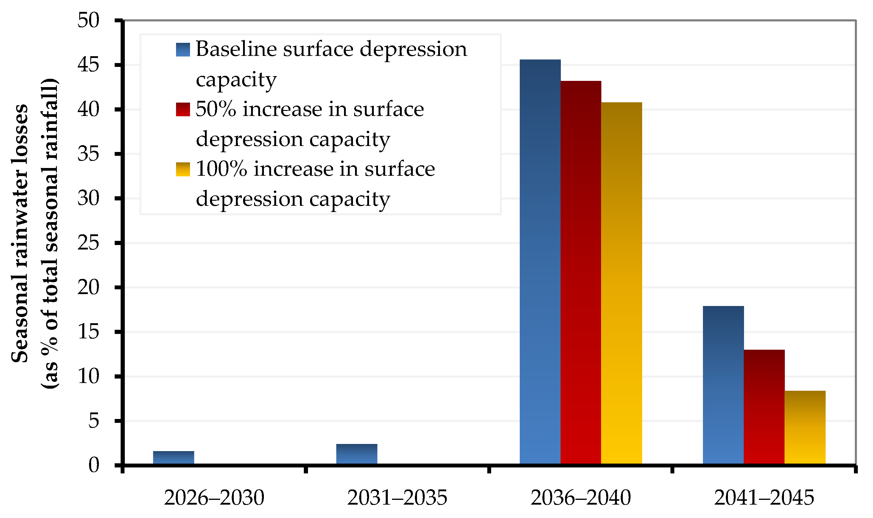
3.2.3. Surface Storage Capacity: A Potential Tool to Cope with Climate Changes by Mitigating Future Rainwater Losses, Thus the Future Increase in Irrigation Requirements. CROPWAT Simulations under Different Scenarios of Surface Storage Capacities
4. Conclusions
Author Contributions
Funding
Institutional Review Board Statement
Informed Consent Statement
Data Availability Statement
Acknowledgments
Conflicts of Interest
References
- Masson-Delmotte, V.; Zhai, P.; Pirani, A.; Connors, S.L.; Péan, C.; Berger, S.; Caud, N.; Chen, Y.; Goldfarb, L.; Gomis, M.I.; et al. Climate Change 2021: The Physical Science Basis; Contribution of Working Group I to the Sixth Assessment Report of the Intergovernmental Panel on Climate Change; Cambridge University Press: Cambridge, UK, 2021. [Google Scholar]
- Vahid, K.; Karami, E.; Keshavarz, M. Climate Change and Agriculture: Impacts and Adaptive Responses in Iran. J. Integr. Agric. 2018, 17, 1–15. [Google Scholar]
- Chandio, A.A.; Jiang, Y.; Rehman, A.; Rauf, A. Short and Long-Run Impacts of Climate Change on Agriculture: An Empirical Evidence from China. Int. J. Clim. Chang. Strateg. Manag. 2020, 12, 201–221. [Google Scholar] [CrossRef]
- Singh, M.G.; Kaur, M.; Kaushik, P. Impact of Climate Change on Agriculture and Its Mitigation Strategies: A Review. Sustainability 2021, 13, 1318. [Google Scholar]
- Buda, S.; Gemmer, M.; Jiang, T. Spatial and Temporal Variation of Extreme Precipitation over the Yangtze River Basin. Quat. Int. 2008, 186, 22–31. [Google Scholar]
- Jiabo, Y.; Gentine, P.; Zhou, S.; Sullivan, S.C.; Wang, R.; Zhang, Y.; Guo, S. Large Increase in Global Storm Runoff Extremes Driven by Climate and Anthropogenic Changes. Nat. Commun. 2018, 9, 4389. [Google Scholar]
- Clausius, R. Ueber Die Bewegende Kraft Der Wärme Und Die Gesetze, Welche Sich Daraus Für Die Wärmelehre Selbst Ableiten Lassen. Ann. Phys. 1850, 155, 368–397. [Google Scholar] [CrossRef]
- Xiao, W.; Hao, F.; Cheng, H.; Yang, S.; Zhang, X.; Bu, Q. Estimating Non-Point Source Pollutant Loads for the Large-Scale Basin of the Yangtze River in China. Environ. Earth Sci. 2011, 63, 1079–1092. [Google Scholar]
- Yufu, Z.; Wu, H.; Yao, M.; Zhou, J.; Wu, K.; Hu, M.; Shen, H.; Chen, D. Estimation of Nitrogen Runoff Loss from Croplands in the Yangtze River Basin: A Meta-Analysis. Environ. Pollut. 2021, 272, 116001. [Google Scholar]
- Ai, W.; Yang, D.; Tang, L. Spatiotemporal Variation in Nitrogen Loads and Their Impacts on River Water Quality in the Upper Yangtze River Basin. J. Hydrol. 2020, 590, 125487. [Google Scholar]
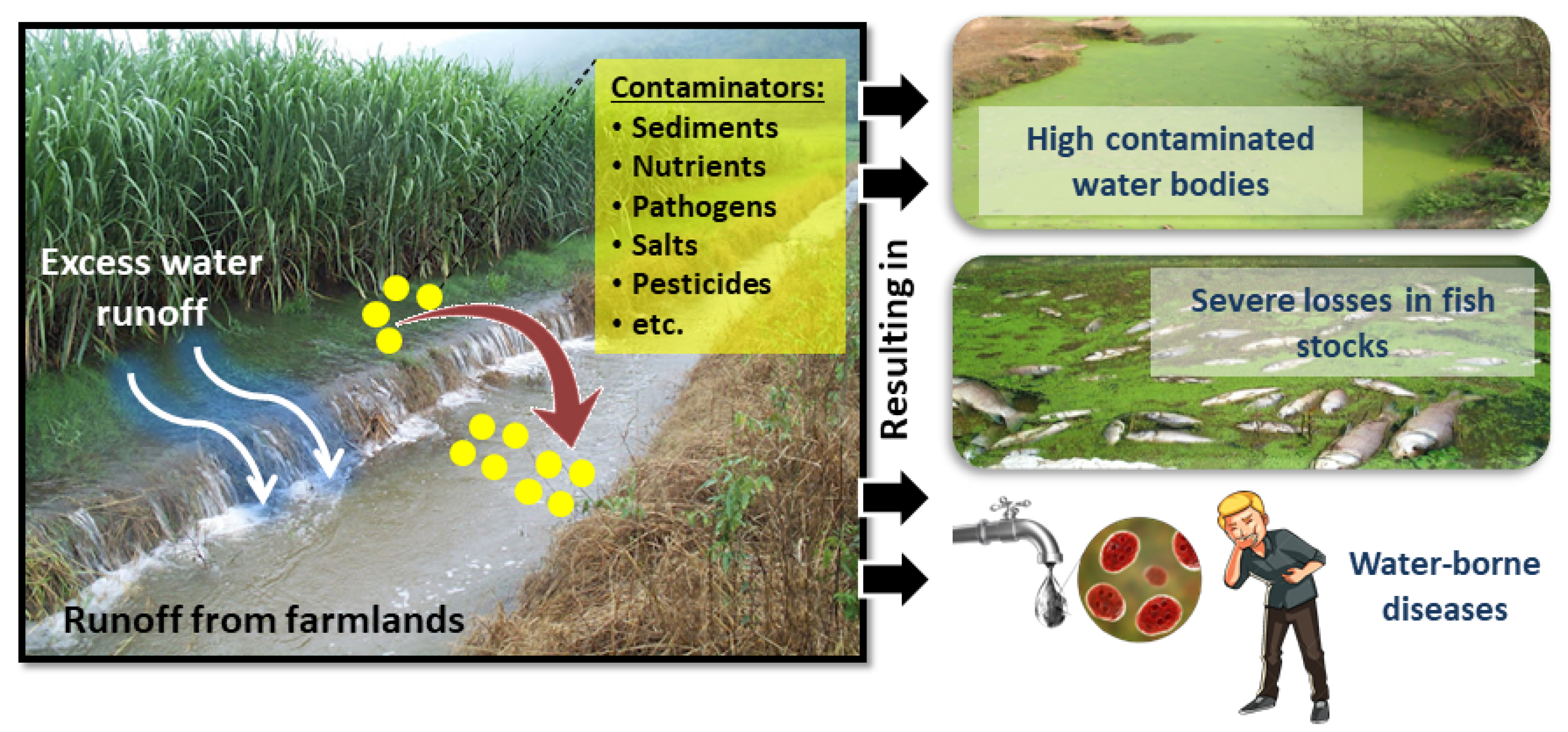
- Whitehead, P.G.; Wilby, R.L.; Battarbee, R.W.; Kernan, M.; Wade, A.J. A Review of the Potential Impacts of Climate Change on Surface Water Quality. Hydrol. Sci. J. 2009, 54, 101–123. [Google Scholar] [CrossRef]
- Yuan, T.; Liu, J.; Guan, X.; Chen, H.; Ren, X.; Wang, S.; Ji, M. Estimation of Potential Agricultural Non-Point Source Pollution for Baiyangdian Basin, China, under Different Environment Protection Policies. PLoS ONE 2020, 15, e0239006. [Google Scholar]
- Jabbar, F.K.; Grote, K. Statistical Assessment of Nonpoint Source Pollution in Agricultural Watersheds in the Lower Grand River Watershed, MO, USA. Environ. Sci. Pollut. Res. 2019, 26, 1487–1506. [Google Scholar] [CrossRef] [Green Version]
- Yan, L.; Li, H.; Cui, G.; Cao, Y. Water Quality Attribution and Simulation of Non-Point Source Pollution Load Flux in the Hulan River Basin. Sci. Rep. 2020, 10, 3012. [Google Scholar]
- Gordon, A.J.; Morton, L.W.; Hobbs, J. Farmer Beliefs and Concerns about Climate Change and Attitudes toward Adaptation and Mitigation: Evidence from Iowa. Clim. Chang. 2013, 118, 551–563. [Google Scholar]
- Hillel, D. Soil-Water Cycle; Academic Press: Cambridge, MA, USA, 2008; pp. 103–120. [Google Scholar]
- Ritesh, K.; Tagert, M.L.M.; Paz, J.O. Evaluating the Nutrient Reduction and Water Supply Benefits of an on-Farm Water Storage (Ofws) System in East Mississippi. Agric. Ecosyst. Environ. 2018, 265, 476–487. [Google Scholar]
- Ngigi, S.N.; Savenije, H.H.G.; Thome, J.N.; Rockström, J.; de Vries, F.W.T.P. Agro-Hydrological Evaluation of on-Farm Rainwater Storage Systems for Supplemental Irrigation in Laikipia District, Kenya. Agric. Water Manag. 2005, 73, 21–41. [Google Scholar] [CrossRef]
- Gunasekhar, N.; Halpin, N.V.; Bell, M.J. Impact of Practice Change on Runoff Water Quality and Vegetable Yield—An on-Farm Case Study. Agriculture 2017, 7, 30. [Google Scholar]
- Martin, S. CROPWAT: A Computer Program for Irrigation Planning and Management; Food and Agriculture Organization of the United Nations: Rome, Italy, 1992. [Google Scholar]
- Elsayed, G.M.; Fattouh, E.M. Assessment of Irrigation Management Practices Using FAO-CROPWAT 8, Case Studies: Tina Plain and East South El-Kantara, Sinai, Egypt. Ain Shams Eng. J. 2021, 12, 1623–1636. [Google Scholar]
- Branislava, L.; Francia, M.; Jacimovic, G. Assessment of Climate Change Impact on Crop Water Requirements in Serbia in 2030 Using CROPWAT Model. In Proceedings of the International Scientific Conference on Environmental Changes and Adaptation Strategies, Skalica, Slovakia, 9–11 September 2013. [Google Scholar]
- Ahmad, B.S.; Pandit, B.A.; Khan, J.N.; Kumar, R.; Jan, R. Water Requirements and Irrigation Scheduling of Maize Crop Using CROPWAT Model. Int. J. Curr. Microbiol. Appl. Sci. 2017, 6, 1662–1670. [Google Scholar]
- Jia, Z.; Chen, C.; Luo, W.; Zou, J.; Wu, W.; Xu, M.; Tang, Y. Hydraulic Conditions Affect Pollutant Removal Efficiency in Distributed Ditches and Ponds in Agricultural Landscapes. Sci. Total. Environ. 2019, 649, 712–721. [Google Scholar] [CrossRef] [PubMed]
- Javad, G.; Gholizadeh, B. Prediction of Rice Water Requirement Using FAO-CROPWAT Model in North Iran under Future Climate Change. Preprints 2016, 2016100134. Available online: https://www.preprints.org/manuscript/201610.0134/v1 (accessed on 20 October 2021).
- Memon, A.V.; Jamsa, S. Crop Water Requirement and Irrigation Scheduling of Soybean and Tomato Crop Using CROPWAT 8.0. Int. Res. J. Eng. Technol. 2018, 5, 669–671. [Google Scholar]
- Doria, R.; Madramootoo, C.A.; Mehdi, B.B. Estimation of Future Crop Water Requirements for 2020 and 2050, Using CROPWAT. In Proceedings of the 2006 IEEE EIC Climate Change Conference, Ottawa, ON, Canada, 10–12 May 2006. [Google Scholar]
- Saon, B.; Chatterjee, S.; Sarkar, S.; Jena, S. Projecting Future Crop Evapotranspiration and Irrigation Requirement of Potato in Lower Gangetic Plains of India Using the CROPWAT 8.0 Model. Potato Res. 2016, 59, 313–327. [Google Scholar]
- Akshay, S.; Deepthi, B.; Mirajkar, A.B.; Adarsh, S. Modeling Future Irrigation Water Demands in the Context of Climate Change: A Case Study of Jayakwadi Command Area, India. Model. Earth Syst. Environ. 2021, 7, 1963–1977. [Google Scholar]
- Ahmed, A.; Luo, W.; Zou, J. DRAINMOD Simulation of Paddy Field Drainage Strategies and Adaptation to Future Climate Change in Lower Reaches of the Yangtze River Basin. Irrig. Drain. 2021, 70, 819–831. [Google Scholar]
- Daniela, J.; Elizalde, A.; Haensler, A.; Hagemann, S.; Kumar, P.; Podzun, R.; Rechid, D.; Remedio, A.R.; Saeed, F.; Sieck, K. Assessing the Transferability of the Regional Climate Model Remo to Different Coordinated Regional Climate Downscaling Experiment (Cordex) Regions. Atmosphere 2012, 3, 181–199. [Google Scholar]
- Yong, L.; Yang, X.; Ye, Q.; Huang, W. Variation Characteristics of Rice Water Requirement in Middle and Lower Reaches of Yangtze River during 19612007. Trans. Chin. Soc. Agric. Eng. 2011, 27, 175–183. [Google Scholar]
- Huanghe, G.; Yu, Z.; Wang, G.; Wang, J.; Ju, Q.; Yang, C.; Fan, C. Impact of Climate Change on Hydrological Extremes in the Yangtze River Basin, China. Stoch. Environ. Res. Risk Assess. 2015, 29, 693–707. [Google Scholar]
- Ulrich, C.; Meehl, G.A.; Boer, G.J.; Stouffer, R.J.; Dix, M.; Noda, A.; Senior, C.A.; Raper, S.; Yap, K.S. Projections of Future Climate Change. In Climate Change 2001: The Scientific Basis; Contribution of Wg1 to the Third Assessment Report of the Ipcc (Tar); Cambridge University Press: Cambridge, UK, 2001; pp. 525–582. [Google Scholar]
- Wossenu, A.; Melesse, A. Climate Change and Evapotranspiration. In Evaporation and Evapotranspiration; Springer: Berlin/Heidelberg, Germany, 2013; pp. 197–202. [Google Scholar]
- Yimin, D.; Wang, W.; Song, R.; Shao, Q.; Jiao, X.; Xing, W. Modeling Spatial and Temporal Variability of the Impact of Climate Change on Rice Irrigation Water Requirements in the Middle and Lower Reaches of the Yangtze River, China. Agric. Water Manag. 2017, 193, 89–101. [Google Scholar]
- Reun, Y.P.; Choi, J. Effects of Shift in Growing Season Due to Climate Change on Rice Yield and Crop Water Requirements. Paddy Water Environ. 2020, 18, 291–307. [Google Scholar]
- Stern, R.; van der Merwe, A.J.; Laker, M.C.; Shainberg, I. Effect of Soil Surface Treatments on Runoff and Wheat Yields under Irrigation. Agron. J. 1992, 84, 114–119. [Google Scholar] [CrossRef]


| Soil Property | Value |
|---|---|
| Total available soil moisture (FC-WP) | 140 mm/m |
| Initial soil moisture depletion | 50% |
| Drainable porosity (SAT-FC) | 6% |
| Water availability at planting | 1 mm WD |
| Maximum rain infiltration rate | 30 mm/day |
Publisher’s Note: MDPI stays neutral with regard to jurisdictional claims in published maps and institutional affiliations. |
© 2021 by the authors. Licensee MDPI, Basel, Switzerland. This article is an open access article distributed under the terms and conditions of the Creative Commons Attribution (CC BY) license (https://creativecommons.org/licenses/by/4.0/).
Share and Cite
Awad, A.; Luo, W.; Al-Ansari, N.; Elbeltagi, A.; El-Rawy, M.; Farres, H.N.; Gabr, M.E.-S. Farmers’ Awareness in the Context of Climate Change: An Underutilized Way for Ensuring Sustainable Farmland Adaptation and Surface Water Quality. Sustainability 2021, 13, 11802. https://doi.org/10.3390/su132111802
Awad A, Luo W, Al-Ansari N, Elbeltagi A, El-Rawy M, Farres HN, Gabr ME-S. Farmers’ Awareness in the Context of Climate Change: An Underutilized Way for Ensuring Sustainable Farmland Adaptation and Surface Water Quality. Sustainability. 2021; 13(21):11802. https://doi.org/10.3390/su132111802
Chicago/Turabian StyleAwad, Ahmed, Wan Luo, Nadhir Al-Ansari, Ahmed Elbeltagi, Mustafa El-Rawy, Hesham N. Farres, and Mohamed EL-Sayed Gabr. 2021. "Farmers’ Awareness in the Context of Climate Change: An Underutilized Way for Ensuring Sustainable Farmland Adaptation and Surface Water Quality" Sustainability 13, no. 21: 11802. https://doi.org/10.3390/su132111802
APA StyleAwad, A., Luo, W., Al-Ansari, N., Elbeltagi, A., El-Rawy, M., Farres, H. N., & Gabr, M. E.-S. (2021). Farmers’ Awareness in the Context of Climate Change: An Underutilized Way for Ensuring Sustainable Farmland Adaptation and Surface Water Quality. Sustainability, 13(21), 11802. https://doi.org/10.3390/su132111802