Article

Water Retention Performance at Low-Impact Development (LID) Field Sites in Taipei, Taiwan

1
Department of Civil Engineering, National Taipei University of Technology, Taipei 10608, Taiwan
2
Department of Land Resources, Chinese Culture University, Taipei 11114, Taiwan
*
Author to whom correspondence should be addressed.
Sustainability 2021, 13(2), 759; https://doi.org/10.3390/su13020759
Submission received: 29 November 2020 / Revised: 7 January 2021 / Accepted: 8 January 2021 / Published: 14 January 2021
(This article belongs to the Special Issue Sustainable Urban Stormwater Management)

Abstract

:
Low-impact development (LID) aims to retain stormwater at source sites rather than achieve water drainage. The infiltration and storage of rainwater on site is the most commonly applied LID design concept, turning impervious pavements into pervious pavements. In this study, three field sites in Taipei city, Taiwan, were monitored. Two of the sites were located on campuses, and one site was a roadside location. They were constructed at different times and had distinct purposes, but the common design aspect was the infiltration function of the ground surface. We monitored the water retention performance at the above three sites and applied a verified stormwater management model (SWMM) to characterize the performance at these case sites. The observed data show that if the accumulative rainfall was lower than 20 mm, the water retention rate at each of the three case sites reached almost 50%; at 60 mm rainfall, the rate was 40%. With increased rainfall amount, the water retention rate decreased because the storage capacity was limited. Because water retention is typically controlled by the infiltration capacity, the rainfall intensity dominated the performance. At the three field sites, the water retention rate was 40% on average at a rainfall intensity below 20 mm/h. Above this rainfall intensity, the infiltration performance of the pervious pavement decreased. The verified model was applied to assess the performance at the three sites under the Taipei city drainage system design standard, i.e., the five-year recurrent period storm level, at 78.8 mm/h. The results demonstrate that the water retention rates were 9.1%, 14.2%, and 61.0% at the three sites, indicating that the pervious pavement could reduce the loading of the current stormwater drainage system. Dispersed sites should be considered in urban stormwater management to mitigate flooding risk in urban areas.

1. Introduction

Urban stormwater management is important for citizens. An effective drainage system facilitates the quick drainage of rainfall runoff to avoid possible flooding. However, under high urbanization, more buildings and roads are built. The loss of the water-retaining function of soil in urban areas changes the hydrologic cycle and increases the runoff quantity [1]. By increasing runoff volume and flow rate, conventional concentrated and large-scale drainage systems might be limited in their adaptability to dynamic changes in urban surfaces and climate conditions [2,3]. Therefore, runoff retention at the source has become a mainstream method. The application of various infiltration or storage facilities to retain the increased runoff generated from impervious grounds could reduce the urban flooding risk, and this idea has been widely implemented in many cities.
The modification of impervious pavement to pervious pavement is a common practice to retain rainwater in source areas. In highly developed cities, the area of impervious pavement is large. The enhancement of the infiltration capacity of the pavement facilitates the retention and deceleration of runoff, and the infiltrated water supplements groundwater, which benefits the underground ecosystem. Weiss et al. [4] reviewed the use of permeable pavement over the past two decades and emphasized that the infiltration capacity and design and construction methods were critical to overall performance. Pervious pavement has been recommended as a low-impact development (LID) facility. The LID method effectively manages stormwater at the source with decentralized microscale control measures [5,6]. The LID method has been effectively applied in Taiwan, achieving an average runoff reduction of approximately 30% [7,8,9]. In Taipei city, the capital city of Taiwan, the government has aimed to establish a sponge city since 2015. A sponge city is a city that functions like a sponge, which absorbs water and adapts to notable rainfall changes. In the future vision of Taipei city, the sponge city policy aims to upgrade the urban water environment, including a resilient and adaptive water environment, sustainable water use, and public-friendly water spaces.
Many studies have proven the performance of LIDs through experimental cases, including studies of permeable pavement [10,11,12], bioretentions [13], and combined LID facilities [14,15]. Some studies used modeling tools to assess the benefits of LIDs in managing urban stormwater, such as Ahiablame et al. [16], Lee et al. [17], Hu et al. [18], Bai et al. [19], and Li et al. [20]. However, field monitoring data are still lacking. In particular, it is difficult to assess LIDs at the watershed scale experimentally [21], and it is much more difficult to monitor field sites than to monitor pilot sites, especially in cases in which the LIDs have already been constructed and are in operation. Although there are many cases in China, quantitative evaluations are lacking [20]. The monitoring plan is rarely considered before construction, resulting in few field data of LIDs.
In this study, we monitored three field sites including two pervious pavements and one rain garden to assess their practical contribution to water conservation. Water conservation is attributed to either the infiltration or storage function of the applied facilities. It is calculated as the difference between the runoff inflow and outflow at a given site. Other benefits provided by LIDs, such as water quality improvement and temperature mitigation, were not considered in this study. In addition to using onsite monitoring data, we applied the stormwater management model (SWMM) to supplement the monitoring data. The green approach is expected to enhance urban stormwater management, and in this study, we assessed its performance by analyzing onsite-monitoring and simulated data.

2. Methodology

2.1. Description of the Field Sites

The 3 field sites were built at different times and locations in Taipei city, Taiwan. The first site is the FuHsin site, which is a modified roadside location with permeable pavement constructed in 2016. The second site is the Taipei Tech campus. The entire campus ground surface was retrofitted with pervious pavement from 2002 to 2010. The third site is located in the BeiTou elementary school, and the site was originally an idle corner space, which was turned into a rain garden in 2019. The dimensions of the three sites differed, and they were equipped with various LID facilities.
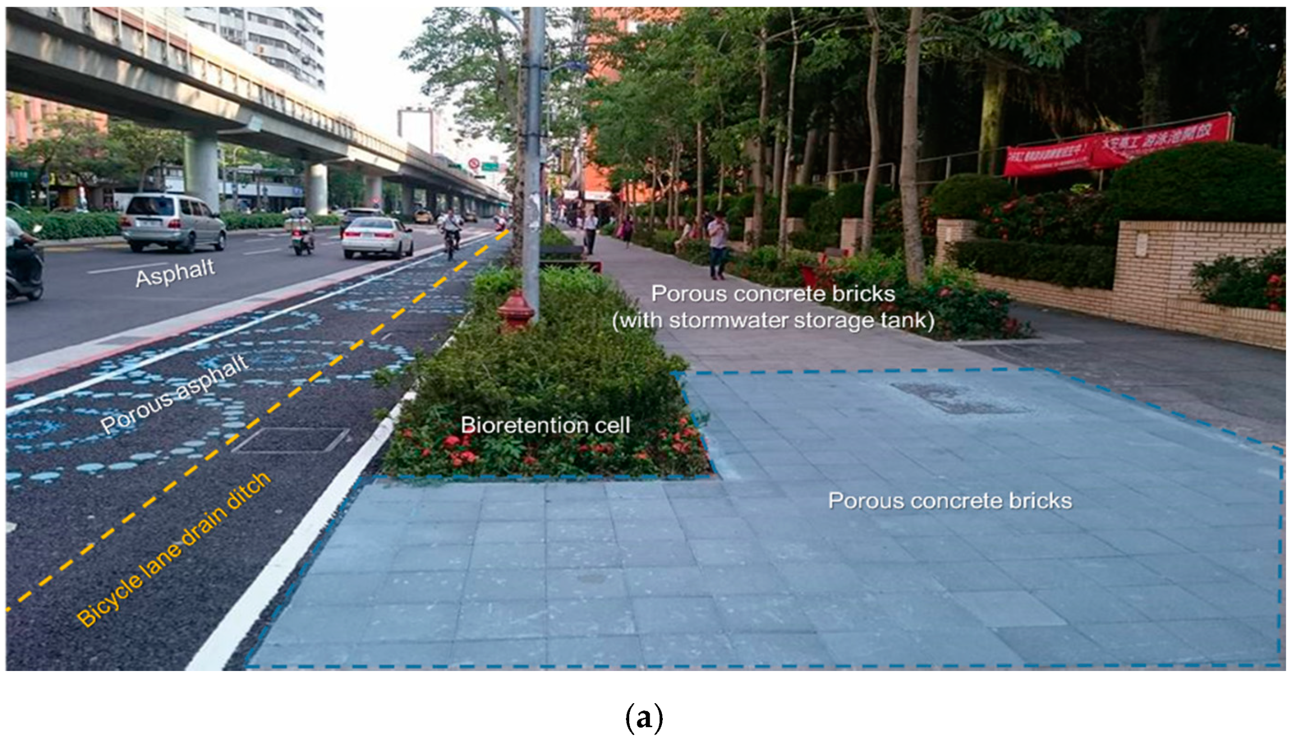
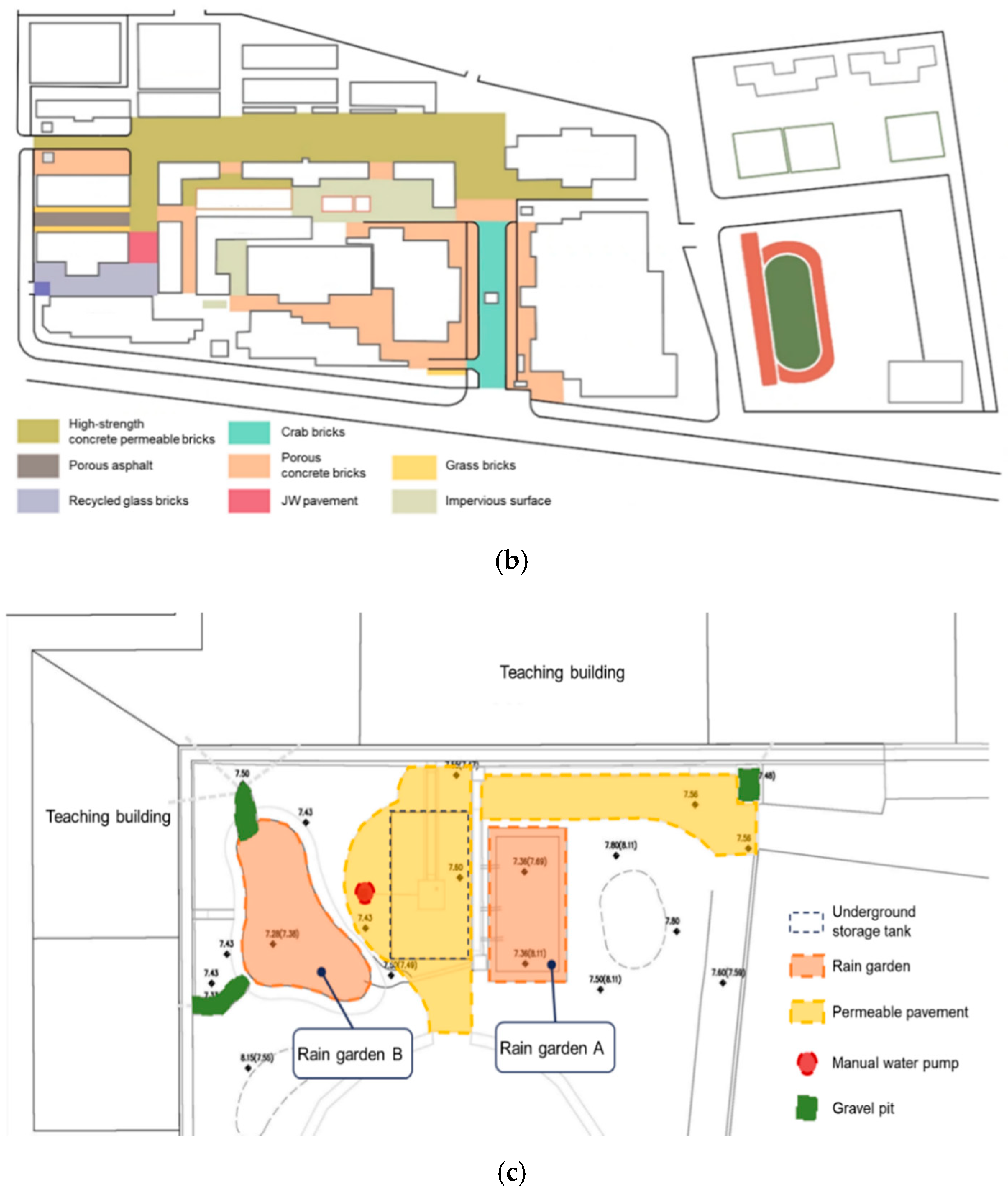
The site along FuHsin south road was settled in 2016, when the bicycle lane was amended, and the pavement was reconstructed as pervious pavement to establish a pilot sponge road. The construction of a sponge city is a Taipei city government policy, and the roadside site is part of this plan to reduce the urban flooding problem. This reconstructed site included pervious pavement, bioretention cells, and underground storage tanks. The total area of this LID site is 1711 m2 and is separated into two subdrainage systems. The total area of the pervious pavement is approximately 755 m2. The second site, the Taipei Tech campus, is more complex. The school retrofitted its campus starting in 2002, and campus transformation was gradually realized. The LID campus was constructed in several stages until 2010. Although many LID facility types were designed across the campus, in the majority of the area, pervious pavement was applied. The third site was newly completed in 2019 in the BeiTou elementary school. This site was sponsored by the Taiwan Environmental Protection Agency (EPA) as a pilot project to increase public awareness of climate change adaptation. Through this project, teachers, students, and neighborhood communities can better understand the climate change issue and the importance of adaptation. In contrast to the retrofitting of the Taipei Tech campus, where LID facilities were dispersed across the campus, the BeiTou elementary school site only covered a corner between two teaching buildings. The total retrofitted area was smaller than 150 m2. The major LID facility at the BeiTou site was a rain garden. In addition to the rain garden, an underground storage tank and the pervious pavement were also included at this site. At the BeiTou site, there were no single sensors to measure the infiltration of the pervious pavement because the area is very small. Therefore, the infiltration performance determined in this study is that of the rain garden. We measured the inflow and outflow of the rain garden to determine its infiltration and storage performance. The locations of the sites are shown in Figure 1, and Figure 2 shows the details of each site.
The original soil at the three sites is sandy clay, and the infiltration rate ranges from 10−4 to 10−6 cm/sec. The FuHsin and Taipei Tech sites are located near the city center, and the BeiTou site is located relatively northwest of the city, which is near the mountain and receives more rain. The annual rainfall at the FuHsin and Taipei Tech sites is 2370 mm, and that at the BeiTou site reaches 2478 mm.

2.2. Monitoring Plan

2.2.1. FuHsin Site

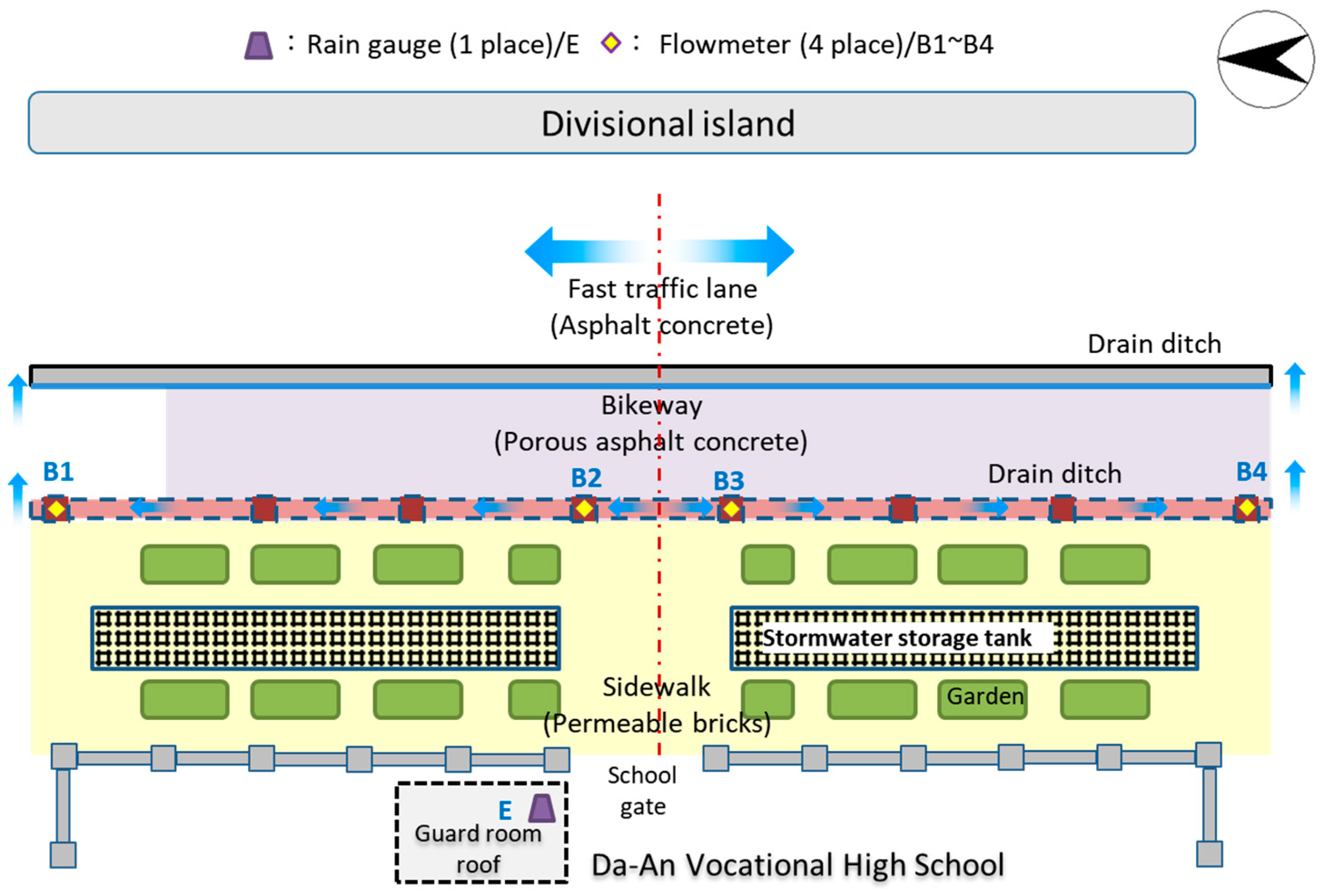
The monitoring period at the FuHsin site lasted from April 2018 to May 2019. An onsite rainfall meter was set up. Four water level meters with weirs were employed to measure the inflow and outflow in the two subdrainage areas. In this study, we determined the performance of one subdrainage area. The placement of the monitoring sensors at the FuHsin site is shown in Figure 3. The data from the B3 and B4 flowmeters were assigned as inflow and outflow, respectively, of the selected subdrainage area.
The total number of monitored events was 40, and a summary is listed in Table 1. The highest-rainfall event occurred on 8 September 2018, during which the total rainfall amount was 152 mm and the instant maximum rainfall intensity was 94 mm/h. This intensity was higher than the design standard of the Taipei stormwater system, 78.8 mm/h, and resulted in temporary ponding. However, the total duration was 6 h, and the average intensity was 25.33 mm/h, less than the design value.

2.2.2. Taipei Tech Site

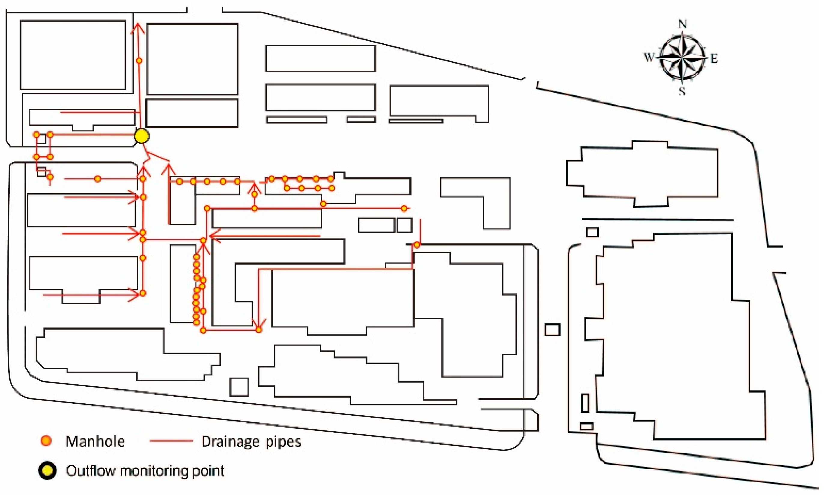
The monitoring period at the Taipei Tech site lasted from May 2018 to May 2019. Because the LID facilities were dispersedly located across the campus and the construction times differed, we measured the final runoff output and applied a modeling tool to obtain inflow data. Prior to the determination of the water conservation rate, the model was calibrated and verified and then adopted to calculate the water conservation rate. Figure 4 shows the drainage system on the campus and the outflow monitoring location.
Rainfall data were obtained on the campus, and flow data were acquired by an onsite flowmeter. The total number of monitored rainfall events was 37. Similarly to the monitoring data at the FuHsin site, the highest-rainfall event occurred on 8 September 2018. However, the rainfall data were slightly different. The total rainfall was 187.4 mm, and the instantaneous maximum rainfall intensity reached 111.8 mm/h. Table 2 summarizes the monitored rainfall events at the Taipei Tech site.

2.2.3. BeiTou Site

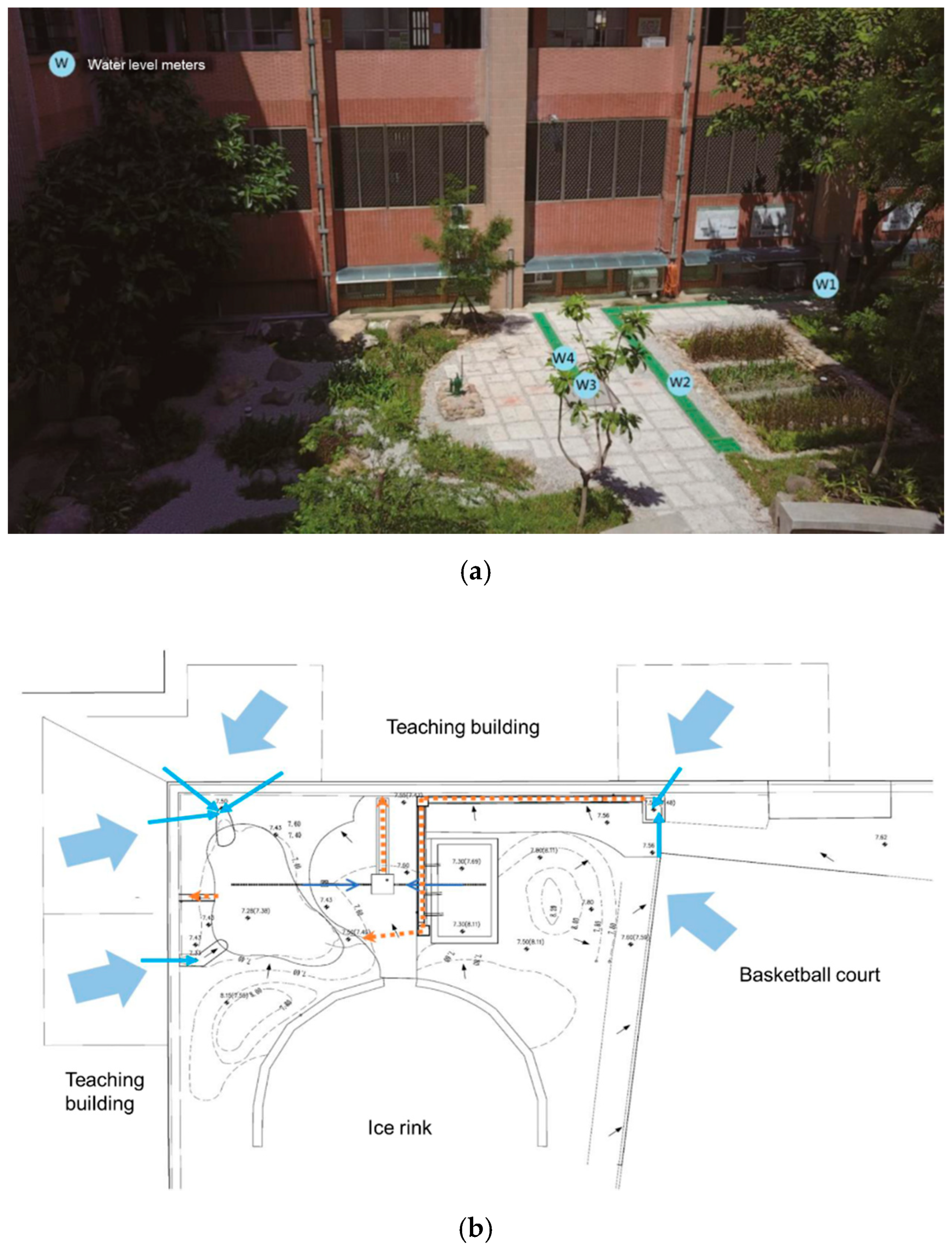
The BeiTou site is a new pilot project, and all sensors were integrated with the Internet of Things (IoT) system. We acquired instantaneous monitoring data on a website. The data included the temperature, water level and flow rate. In this study, we focused on the water conservation performance of the rain garden facility. There were four water level meters (Figure 5). This corner site contained several inflows, which included the runoff from a nearby basketball court and roofs of teaching buildings. The roof runoff directly flowed into the site without monitoring. The roof runoff was determined based on the calculated roof area and rainfall data. W1 and W2 monitored the inflow and outflow, respectively, of the rain garden. W3 monitored the water level in the underground storage tank, and W4 monitored the overflow of the underground tank, thus representing the outflow of the whole site. In this study, we used the data of W1 and W2 to assess the performance of the rain garden, regarded as a type of infiltration and storage facility.
Rainfall data were obtained with a rain gauge at the elementary school site. From January to July 2020, a total of 13 rainfall events were monitored. The highest-rainfall event occurred on 23 May during which a rainfall amount of 116.5 mm was recorded with a long duration of 54 h. The average rainfall intensity was only 2.17 mm/h. The highest intensity was observed on 27 March which was a short event, and the intensity reached 67.5 mm/h. The monitored rainfall events at the BeiTou site are listed in Table 3.

2.3. The SWMM and the Model Validation Process

In addition to the obtained real monitoring data, we applied a model tool to assess the performance at these sites. There were two reasons for the model tool application. One reason was to assess the performance at the Taipei Tech site. Although we monitored the onsite outflow, we could not acquire inflow data. Therefore, a model was needed to simulate the runoff generated during rainfall events. The other reason was to simulate the performance under the design storm standard of the Taipei city drainage system, which indicates a 5-year recurrent period level of 78.8 mm/h. Once the model tool was verified with the acquired real observation data, it served as a useful tool to assess different scenarios.
The SWMM was developed by the USEPA and has been widely adopted. The SWMM is capable of calculating various hydrologic processes and quantifying runoff curves from urban or nonurban areas under single short- or long-term precipitation events. It is a useful tool to design drainage systems and to evaluate stormwater management practices. The model includes a LID module to assess the effectiveness of different types of LIDs in managing runoff. Many studies have adopted the SWMM to assess LID performance [17,19,20,22], and information on this model can be obtained from its official website and manual [23]. In Taiwan, the SWMM has been applied in many fields, such as urban stormwater management, flooding assessment, LID applications, watershed management, and nonpoint source pollution determination. Therefore, this model was chosen in this study.
Before applying a model tool, the model should be verified against onsite observations to confirm the rationality of the model parameters. With regard to the three sites, we used the real dimensions of each designed facility and onsite geographic data, such as soil properties, land use, slope, and existing drainage pipes. After establishing an SWMM for each site, the simulation results were compared to the observed data. The coefficient of determination (R2) was adopted to determine the applicability of the simulation results. For each site, one event was used to calibrate the model, and the calibrated model parameters were then applied to other rainfall events to determine whether the simulations were acceptable or not. If the R2 is larger than 0.5, and the results were regarded as acceptable. If the verification results were not acceptable, the model parameters were adjusted. If the results were acceptable, the model parameters were then applied to another event. We applied the calibrated model parameters to the other events to verify their performance. The calibration and verification process was considered accomplished when acceptable results with calibrated model parameters for at least five events were obtained. For the FuHsin site, we tested 13 events, and seven events were tested for the BeiTou site. The Taipei Tech case is special. The observations at the Taipei Tech site are from after the construction of the LIDs; therefore, we needed to simulate the runoff before the LIDs. All events were used for model calibration and verification in Taipei Tech site.

3. Results and Discussion

3.1. Verification of the SWMM

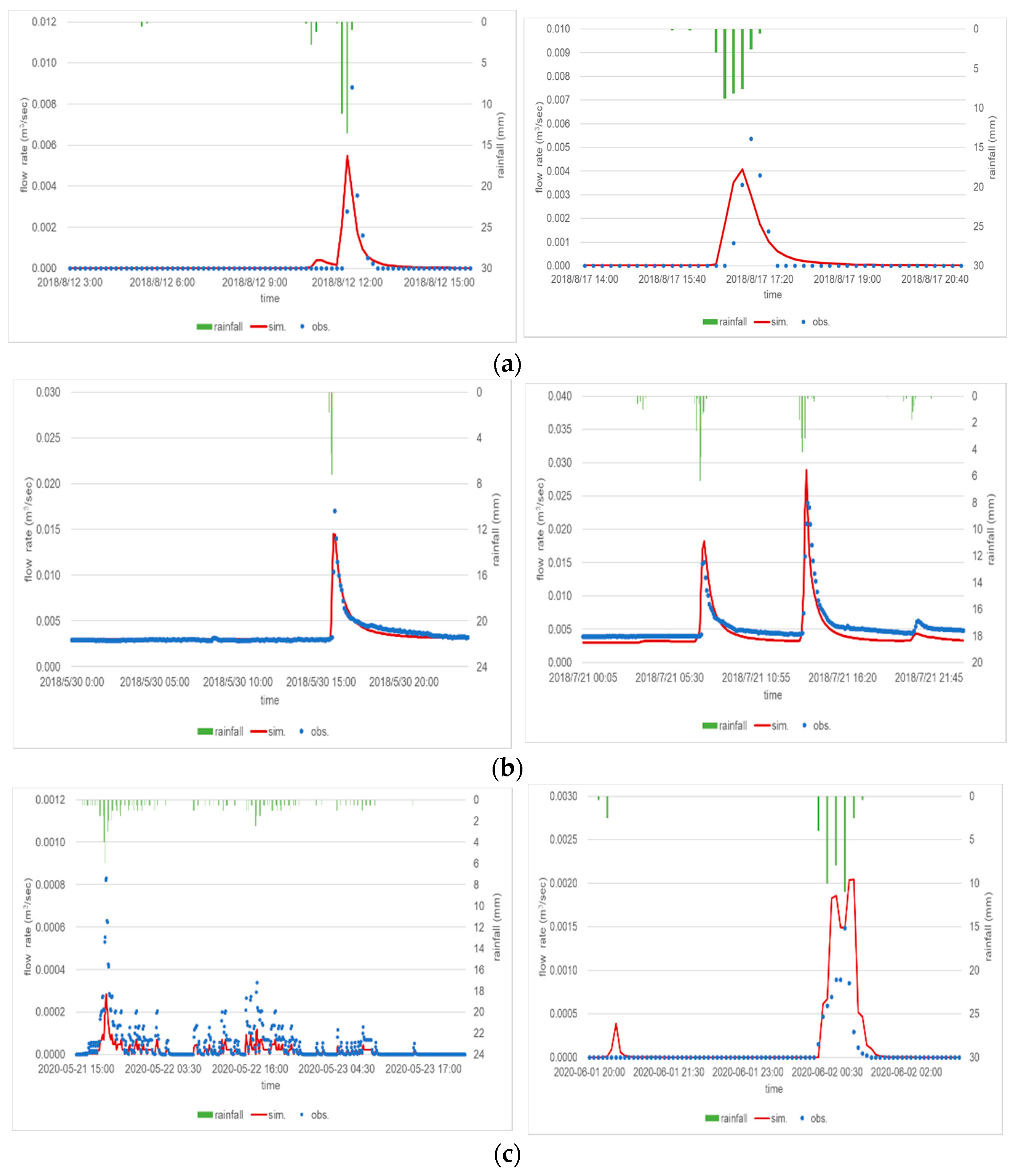
The model calibration and verification results for the three sites are shown in Figure 6. In this manuscript, we show the events that had the best performance. The calibration and verification were based on the different rainfall events. For example, the rainfall recorded on 12 August 2018, was used for calibration, and the event on 17 August 2018, was used for verification of FuHsin site. The results for the FuHsin site are shown in Figure 6a, and the R2 values associated with the calibration and verification were 0.94 and 0.92, respectively. Figure 6b shows the results for the Taipei Tech site, and the R2 values of the calibration and verification were 0.93 and 0.9, respectively. The model results for the BeiTou site are shown in Figure 6c, and the R2 values were 0.72 and 0.74 for calibration and verification, respectively.

3.2. Observation and Simulation Results for the 3 Sites

The water conservation rate is calculated from the rainfall amount and rainfall intensity. The water conservation rates based on the observations and verified model simulations are shown in Figure 7, Figure 8 and Figure 9.
At the FuHsin site, the lowest water conservation rate was 17%, which occurred under the largest rainfall amount of 152 mm and the highest rainfall intensity of 25.2 mm/h. When the total rainfall amount was smaller than 60 mm, the water conservation rate reached almost 40%. The collected rainfall at this site was mostly in the range of 20 to 60 mm, and the average water conservation rate was 40%, but the variation was high, ranging from 20% to 90%. The rate decreased with the rainfall amount, but an obvious decreasing trend with the rainfall intensity was not observed. A high water conservation rate occurred when the rainfall intensity was lower than 5 mm/h, and the rate even reached up to 90%. At a rainfall intensity between 5 and 30 mm/h, the average rate was 40%, with a variation ranging from 20% to 60%. Because missing onsite data occurred, there were more simulation events than observations. We found that the variability in the observations was higher than that in the simulations, which resulted in different performance trends. Even though different performance trends were observed between the observations and simulations, in general, the average water conservation rate at the FuHsin site and its relationship with the rainfall amount and intensity were consistent.
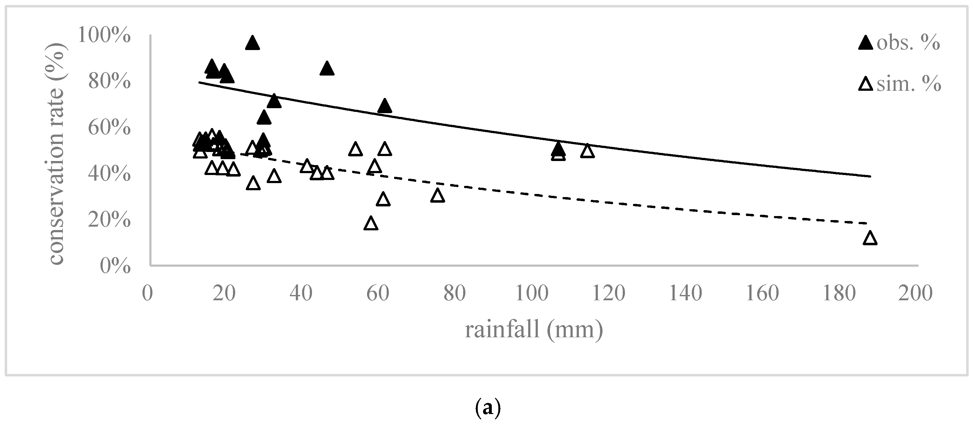
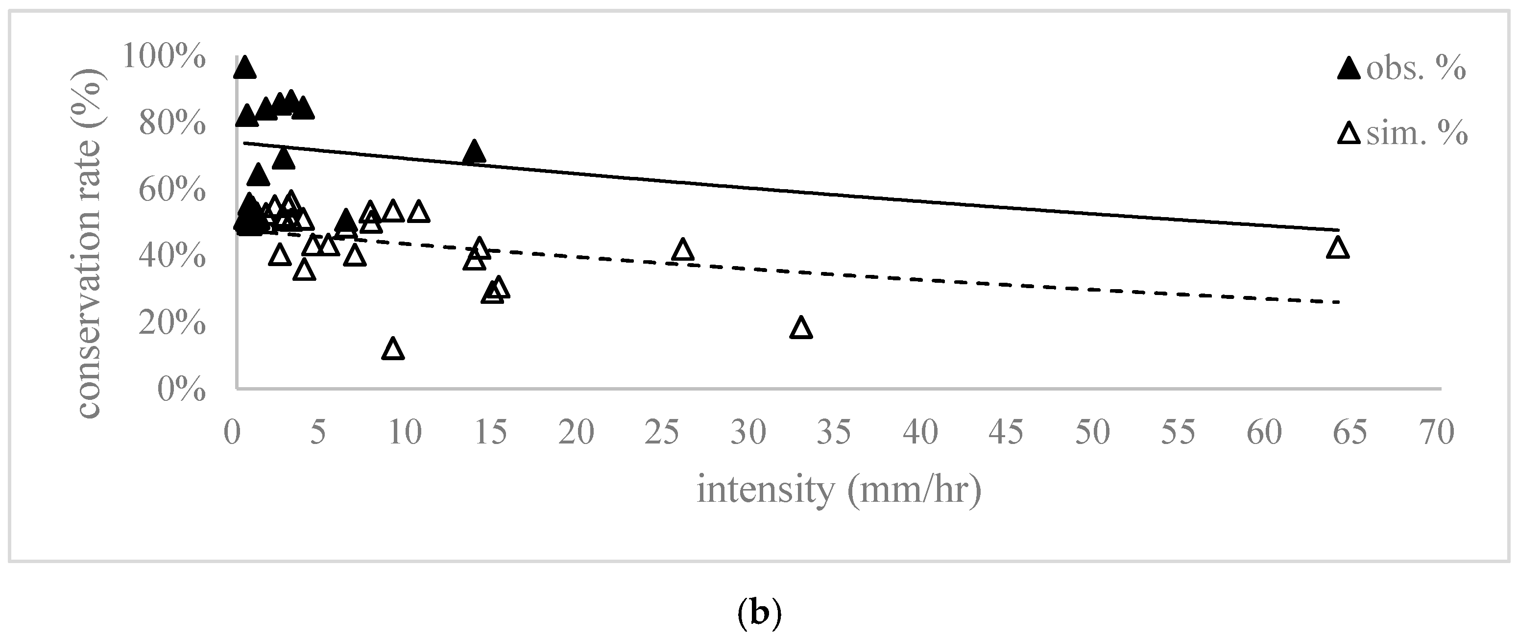
The observed range of the rainfall amount at the Taipei Tech site is wider than that at the FuHsin site. Because of the wide range of rainfall properties, the relationship between the water conservation rate and the rainfall amount and intensity is clear. High rainfall amounts and intensities lead to a low water conservation performance. The lowest water conservation rate is 12%, occurring under the largest rainfall amount of 187 mm. When the rainfall amount is smaller than 30 mm, the water conservation rate is approximately 60%. When the rainfall amount is smaller than 60 mm, the water conservation rate reaches approximately 40%. For most of the monitored rainfall events, the rainfall amount is between 10 and 60 mm. In the 10–60 mm rainfall event, the simulated water conservation rate is approximately 40%, but the observations indicate a rate higher than 60%. The water conservation rate also decreases with the rainfall intensity. Most rainfall intensity observations are lower than 5 mm/h, and the results reveal a high conservation rate ranging from 40% to 90%. When the rainfall intensity increases to 20 mm/h, the conservation rate decreases to 40%, and at a rainfall intensity of 40 mm/h, the rate decreases to 20%.
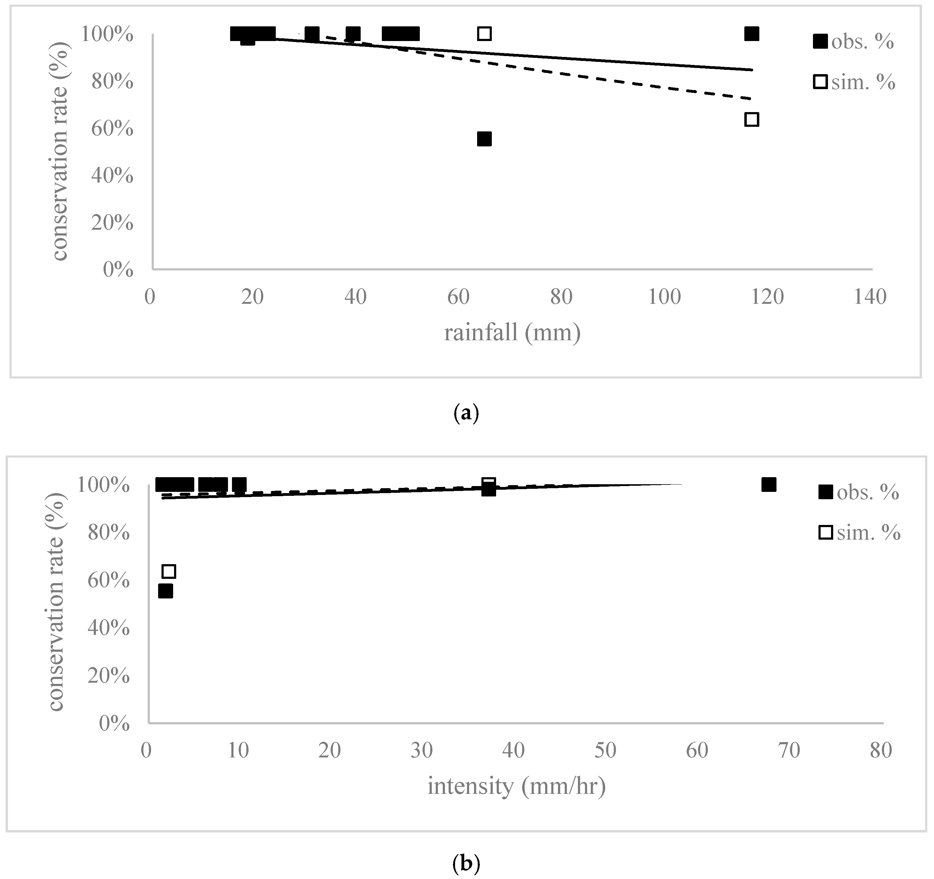
During the monitoring of the BeiTou site, the rainfall events exhibited a low intensity, and the rainfall amounts were all smaller than 60 mm. The largest rainfall amount was 116.5 mm with a long duration, and the intensity was only 2.17 mm/h. Among the 13 rainfall events, only one event resulted in a 64% water conservation rate. The other 12 events yielded a 100% rate because no outflow was observed from the rain garden. This might occur because of the small collection area and sufficient infiltration and storage space. Because of the onsite limitations, we collected surface runoff data from part of the nearby basketball court and teaching building roofs. It was impossible to collect all the runoff from the entire surface of the basketball court and teaching building roofs because of the orientations of their surface slopes. The small drainage area might explain why this site attained a perfect water conservation rate of 100% in most rainfall events. According to the infiltration and storage capacity of the rain garden and the drainage area, this rain garden was able to manage the runoff when the rainfall amount was smaller than 80 mm. Figure 9 shows the results for the BeiTou site. Because of the limited rainfall events, no relationship was determined with the rainfall amount and intensity at this site, in contrast to the performance at the previous two sites.
In summary, the average water conservation rate at the three sites was 40% under rainfall amounts smaller than 60 mm and intensities lower than 20 mm/h. The water conservation rate decreased with increasing rainfall amount and intensity. Compared to the other sites, the BeiTou site, with its relatively small drainage area, exhibited good water conservation ability. The performance at the Taipei Tech site was better than that at the FuHsin site. When we applied the regression equation determined from the observations at the three sites, the water conservation rate could be compared at the same rainfall and intensity. A summary is listed in the Table 4. The water conservation rate at the Taipei Tech site could be 10% higher than that at the FuHsin site. For example, when the rainfall is 20 mm, the performance at the FuHsin and Taipei Tech sites is 60% and 76%, respectively. At a rainfall intensity of 5 mm/h, the water conservation rate is 61% at the FuHsin site and 71% at the Taipei Tech site. Because there are fewer rainfall events, the performance at the BeiTou site is almost 100%.

3.3. Performance Simulation with the Design Storm Standard

In addition to the performance during the monitored rainfall events, the performance under the city drainage design standard is also simulated. Taipei city is the capital city of Taiwan, and its stormwater drainage system follows the highest design standard, which is a rainfall intensity of 78.8 mm/h with a 5-year return period. The above rainfall intensity of 78.8 mm/h is regarded as the highest intensity occurring once every 5 years. During the monitoring periods at the three sites, the average intensity did not exceed 70 mm/h. We used a designed storm as a rainfall event to determine the performance at the studied sites.
The verified SWMM was applied to calculate the water conservation rate at each site under the design storm, and the results are listed in Table 5. At such a high rainfall intensity, the small-scale FuHsin site only retained 9.1% of the runoff, indicating that more than 90% of the runoff flowed out and was not retained at this site. If there is no extra storage space, the infiltration function cannot support a high rainfall intensity and high runoff. Under the design storm, 14.2% of the rainfall was retained at the Taipei Tech site. Moreover, 61.0% of the rainfall was retained at the BeiTou site because of the extra storage space provided by the rain garden. If pervious pavement is applied to conserve water or to reduce the flooding risk, not only the infiltration capacity but also the storage function should be considered in facility design.

3.4. Factors Affecting the Water Conservation Capability of LIDs

The three field sites achieved satisfactory water conservation rates, i.e., the reduction of runoff, and on average, 40% of the runoff can be retained at these sites. This performance falls within the range reported in previous LID studies. Abbott and Comino-Mateos [11] conducted an in-situ study of a permeable pavement system in a car park and reported that 77.5% of the runoff was retained in the system. Jia et al. [14] monitored the field performance of an LID that received runoff from tennis courts and basketball courts in China. They found that bioretention could reduce 47–80% of the runoff volume and grassed swale could reduce 9–74% of the runoff. Mai et al. [15] established an LID experimental site and reported a 43–94% volume reduction of greenbelt and a 13–74% volume reduction of permeable pavement. Vaillancourt et al. [12] studied the performance of permeable pavement in Canada and reported runoff reductions ranging from 26% to 98%. Brattebo and Booth [10] tested four commercial permeable pavement systems over 6 years, and almost no surface runoff occurred. Compared to the onsite LID performance in these previous studies, the performance at the three sites in the present study was average.
The experimental cases consistently showed a high runoff reduction, up to 100%. This reduction was achieved because the drainage areas are small, meaning that the LID area is large and potentially covers the entire drainage area. Watershed-scale studies have shown that LID practices contribute to lower water retention. For example, Ahiablame and Shakya [24] applied the PCSWMM to an urban watershed in Illinois, USA, and found LID practices could achieve 3–47% runoff reductions. Lee et al. [17] applied the SWMM to analyze the impact of runoff of LID practices in a district in Korea and found that approximately 33–37% of runoff volume can be reduced.
The rainfall volume and intensity can impact the performance of LIDs. The ratio of LID area to drainage area also influences LID performance. A greater LID area should yield better performance. However, this should be discussed. In this study, the best performance of water conservation was found at the BeiTou site, followed by the Taipei Tech and FuHsin sites. However, the ratio of LID area to drainage area is 11%, 30%, and 72% for the BeiTou, Taipei Tech, and FuHsin sites, respectively. Although the ratio is small at the BeiTou site, the extra storage space at this site provides a large retention capacity and results in the best performance. The FuHsin site has large LID areas, but the rectangular shape of the drainage area produces a short runoff route, and the runoff quickly passes by the pervious pavement without infiltrating. Therefore, the performance at FuHsin is lower than that at the Taipei Tech site, where the LID area is less but the runoff routes are longer. When designing a LID site, not only the required LID area but also the runoff routes should be considered to optimize LID performance. If the drainage area is very small and the LID area is large, the LID will not be economically effective. In contrast, when the drainage collection area is very large, the performance of the associated facilities is expected to deteriorate. Therefore, when designing similar pavement systems or LID facilities, the ratio of the LID area to the drainage collection area and the length of the runoff routes should be considered.
Another factor influencing LID performance is the groundwater and surface water from outside surfaces. Taipei city is located in a basin area, and the groundwater level is high. During rainfall events, the groundwater level may increase and affect the infiltration and storage capacity. In our cases, some monitoring data were unreliable, and the water conservation rates were very low. Unlike the Taipei Tech and BeiTou sites, which are located on campuses, the FuHsin site is located along a road. In some rainfall events, some runoff from the outside surface area flows into this site, and the water budget is not balanced. When analyzing monitoring data, onsite impact factors should be evaluated.

4. Conclusions

This study collected data at three LID sites to characterize their water conservation performance. The performance is affected by the original design dimensions or subsequent maintenance practices, but in this study, we focused on their final performance and the relationship with rainfall properties. A monitoring plan was not initially designed except at the BeiTou site. Therefore, it was difficult to obtain complete observation data to evaluate the performance, which is why we required a modeling tool for assessment purposes. In this study, we integrated real observations and simulations to determine the performance at these sites. This methodology could be applied where there are insufficient observations.
According to the performance at the three sites in Taipei city, pervious pavement systems, including rain gardens, are helpful for urban stormwater management. When the rainfall amount is smaller than 20 mm and the intensity is lower than 20 mm/h, at least half of the rainfall is retained onsite and outflow does not occur. If storage space is added below the surface, the rate can be higher; for example, the water conservation ratio at the BeiTou site approaches 100%. In addition to the rainfall properties, the length of runoff routes affects the water conservation performance. At a high rainfall intensity, a short runoff route can cause quick runoff outflow, which limits infiltration or onsite retention, as observed at the FuHsin site.

Author Contributions

Conceptualization, C.-F.C.; Data curation, T.-C.Y.; Formal analysis, C.-F.C.; Investigation, J.-Y.L.; Methodology, T.-C.Y. and C.-F.C.; Project administration, J.-Y.L.; Resources, J.-Y.L.; Software, T.-C.Y.; Writing–original draft, C.-F.C. All authors have read and agreed to the published version of the manuscript.

Funding

This study was received partly funding from Taipei city government, the Environmental Protection Administration, and Ministry of Science and Technology, Taiwan, R.O.C.

Data Availability Statement

Data available in a publicly accessible repository that does not issue DOIs Publicly available datasets were analyzed in this study.

Acknowledgments

The authors thank Taipei Municipal Daan Vocational High School and BeiTou Elementary School for their helps on field site monitoring and thank the two reviewers for their valuable comments, which helped improve the quality of this manuscript.

Conflicts of Interest

The authors declare no conflict of interest.

References

  1. Booth, D.B.; Leavitt, J. Field Evaluation of Permeable Pavement Systems for Improved Stormwater Management. J. Am. Plan. Assoc. 1999, 65, 314–325. [Google Scholar] [CrossRef]
  2. Morsy, M.M.; Goodall, J.L.; Shatnawi, F.M.; Meadows, M.E. Distributed Stormwater Controls for Flood Mitigation within Urbanized Watersheds: Case Study of Rocky Branch Watershed in Columbia, South Carolina. J. Hydrol. Eng. 2016, 21, 05016025. [Google Scholar] [CrossRef]
  3. Bae, C.; Lee, D.K. Effects of low-impact development practices for flood events at the catchment scale in a highly developed urban area. Int. J. Disaster Risk Reduct. 2020, 44, 101412. [Google Scholar] [CrossRef]
  4. Weiss, P.T.; Kayhanian, M.; Gulliver, J.S.; Khazanovich, L. Permeable pavement in northern North American urban areas: Research review and knowledge gaps. Int. J. Pavement Eng. 2019, 20, 143–162. [Google Scholar] [CrossRef]
  5. Li, J.; Deng, C.; Li, Y.; Li, Y.; Song, J. Comprehensive Benefit Evaluation System for Low-Impact Development of Urban Stormwater Management Measures. Water Resour. Manag. 2017, 31, 4745–4758. [Google Scholar] [CrossRef]
  6. Fiori, A.; Volpi, E. On the Effectiveness of LID Infrastructures for the Attenuation of Urban Flooding at the Catchment Scale. Water Resour. Res. 2020, 56. [Google Scholar] [CrossRef]
  7. Lin, J.-Y.; Chen, C.-F.; Ho, C.-C. Evaluating the effectiveness of green roads for runoff control. J. Sustain. Water Built Environ. 2018, 4, 04018001. [Google Scholar] [CrossRef]
  8. Chen, C.-F.; Lin, J.-Y.; Ho, C.-C.; Kuo, C.-T. Performance Evaluation of Combined LID Facilities on Runoff Reduction—A Case of Taipei Tech Campus in Taiwan. In Proceedings of the International Low Impact Development Conference 2018, Nashville, Tennessee, 12–15 August 2018; pp. 223–229. [Google Scholar]
  9. Cheng, Y.-Y.; Lo, S.-L.; Ho, C.-C.; Lin, J.-Y.; Yu, S. Field Testing of Porous Pavement Performance on Runoff and Temperature Control in Taipei City. Water 2019, 11, 2635. [Google Scholar] [CrossRef] [Green Version]
  10. Brattebo, B.O.; Booth, D.B. Long-term stormwater quantity and quality performance of permeable pavement systems. Water Res. 2003, 37, 4369–4376. [Google Scholar] [CrossRef]
  11. Abbott, C.L.; Comino-Mateos, L. In-situ hydraulic performance of a permeable pavement sustainable urban drainage system. Water Environ. J. 2003, 17, 187–190. [Google Scholar] [CrossRef]
  12. Vaillancourt, C.; Duchesne, S.; Pelletier, G. Hydrologic Performance of Permeable Pavement as an Adaptive Measure in Urban Areas: Case Studies near Montreal, Canada. J. Hydrol. Eng. ASCE 2019, 24. [Google Scholar] [CrossRef] [Green Version]
  13. Gulbaz, S.; Kazezyilmaz-Alhan, C.M. Experimental investigation on hydrologic performance of LID with rainfall-watershed-bioretention system. J. Hydrol. Eng. 2016, 22, D4016003. [Google Scholar] [CrossRef]
  14. Jia, H.; Wang, X.; Ti, C.; Zhai, Y.; Field, R.; Tafuri, A.N.; Cai, H.; Yu, S.L. Field monitoring of a LID-BMP treatment train system in China. Environ. Monit. Assess. 2015, 187, 373. [Google Scholar] [CrossRef] [PubMed]
  15. Mai, Y.; Zhang, M.; Chen, W.; Chen, X.; Huang, G.; Li, D. Experimental study on the effects of LID measures on the control of rainfall runoff. Urban Water J. 2018, 15, 827–836. [Google Scholar] [CrossRef]
  16. Ahiablame, L.M.; Engel, B.A.; Chaubey, I. Effectiveness of low impact development practices in two urbanized watersheds; Retrofitting with rain barrel/cistern and porous pavement. J. Environ. Manag. 2013, 119, 151–161. [Google Scholar] [CrossRef]
  17. Lee, J.M.; Hyun, K.H.; Choi, J.S. Analysis of the impact of low impact development on runoff from a new district in Korea. Water Sci. Technol. 2013, 68, 1315–1321. [Google Scholar] [CrossRef]
  18. Hu, M.; Sayama, T.; Zhang, X.; Tanaka, K.; Takara, K.; Yang, H. Evaluation of low impact development approach for mitigating flood inundation at a watershed scale in China. J. Environ. Manag. 2017, 193, 430–438. [Google Scholar] [CrossRef]
  19. Bai, Y.; Li, Y.; Zhang, R.; Zhao, N.; Zeng, X. Comprehensive performance evaluation system based on environmental and economic benefits for optimal allocation of LID facilities. Water 2019, 11, 341. [Google Scholar] [CrossRef] [Green Version]
  20. Li, Q.; Wang, F.; Yu, Y.; Huang, Z.; Li, M.; Guan, Y. Comprehensive performance evaluation of LID practices for the sponge city construction: A case study in Guangxi, China. J. Environ. Manag. 2019, 231, 10–20. [Google Scholar] [CrossRef]
  21. Vogel, J.; Moore, T. Urban stormwater characterization, control, and treatment. Water Environ. Res. 2016, 88, 1918–1950. [Google Scholar] [CrossRef]
  22. Luan, Q.; Fu, X.; Song, C.; Wang, H.; Liu, J.; Wang, Y. Runoff effect evaluation of LID through SWMM in typical mountainous, low-lying urban areas: A case study in China. Water 2017, 9, 439. [Google Scholar] [CrossRef] [Green Version]
  23. Rossman, L.A. Storm Water Management Model User’s Manual Version 5.1; U.S. Environmental Protection Agency: Cincinnati, OH, USA, 2015. [Google Scholar]
  24. Ahiablame, L.; Shakya, R. Modeling flood reduction effects of low impact development at a watershed scale. J. Environ. Manag. 2016, 171, 81–91. [Google Scholar] [CrossRef] [PubMed]
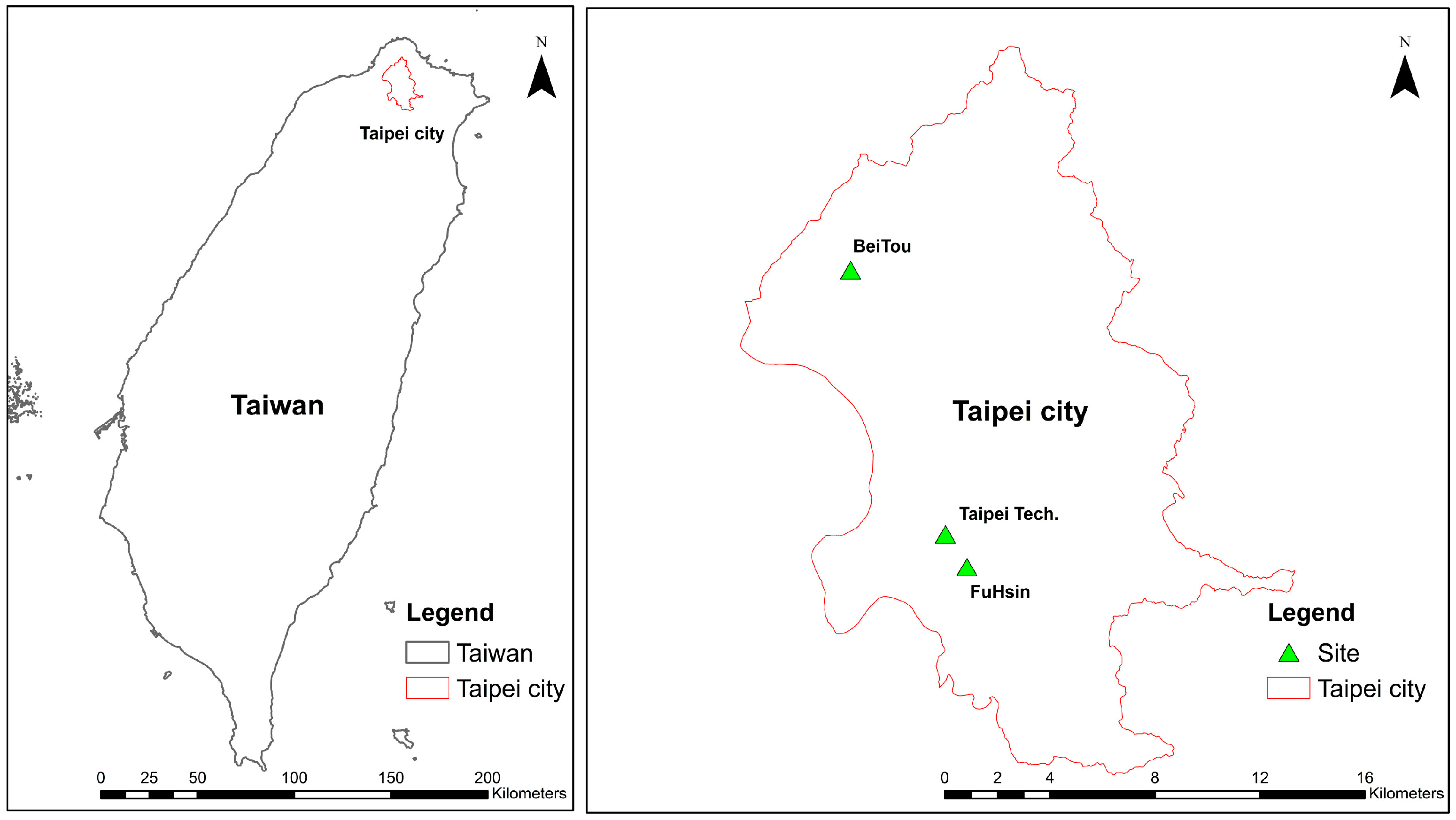
Figure 1. Location of the studied sites in Taipei city. The left panel is a map of Taiwan showing the location of Taipei city, and the right panel shows the locations of the three field sites in this study.
Sustainability 13 00759 g001
Figure 2. Details of the sites. (a) FuHsin south road, (b) Taipei Tech, and (c) BeiTou elementary school.
Sustainability 13 00759 g002aSustainability 13 00759 g002b
Figure 3. Locations of the monitoring sensors at the FuHsin site.
Sustainability 13 00759 g003
Figure 4. Drainage pipes at the Taipei Tech site and the outflow monitoring point.
Sustainability 13 00759 g004
Figure 5. (a) Distribution of the water monitoring points at the BeiTou site and (b) the runoff collection route.
Sustainability 13 00759 g005
Figure 6. Model calibration and verification of the studied sites: (a) FuHsin, (b) Taipei Tech, and (c) BeiTou.
Sustainability 13 00759 g006
Figure 7. Water conservation rate at the FuHsin site. (a) The conservation rate versus rainfall volume and (b) the conservation rate versus rainfall intensity.
Sustainability 13 00759 g007
Figure 8. Water conservation rate at the Taipei Tech site. (a) The conservation rate versus rainfall volume and (b) the conservation rate versus rainfall intensity.
Sustainability 13 00759 g008aSustainability 13 00759 g008b
Figure 9. Water conservation rate of the BeiTou site. (a) The conservation rate versus rainfall volume and (b) the conservation rate versus rainfall intensity.
Sustainability 13 00759 g009
Table 1. Rainfall events monitored at the FuHsin site.
DateTotal Rainfall (mm)Rainfall Duration (h:min)Average Rainfall Intensity (mm/h)
12/4/201835.51:1030.43
16–17/4/201817.88:402.05
8/5/201826.64:006.65
30/5/201818.200:3036.40
10–11/7/2018126.816:107.84
21/7/201826.67:203.63
24/7/201827.82:0013.90
11/8/201830.27:503.86
12/8/201845.86:506.70
17/8/201831.21:4018.72
20/8/20181300:4019.50
30/8/201854.49:205.83
1/9/201822.61:1019.37
7/9/201839.63:5010.33
8/9/2018152.06:0025.33
9/9/201818.417:201.06
15–16/9/201820.427:300.74
25–27/9/201824.235:000.69
10–11/10/201816.813:051.28
11–12/10/201825.817:451.45
16–17/10/201830.811:002.80
1–2/11/201821.842:100.52
23–24/12/201841.230:401.34
16–17/1/201921.125:000.85
23–24/2/201957.422:402.53
6–10/3/201989.484:201.06
25/3/2019156:102.43
29–30/3/2019245:204.50
11/4/201915.68:301.84
15–16/4/20192924:001.21
20–21/4/201940.610:403.81
22/4/201923.85:004.76
1/5/201946.617:102.71
2–3/5/201914.420:300.70
6–7/5/201924.227:100.89
9–10/5/2019148:201.68
17/5/201962.411:405.35
20/5/201957.805:2010.84
27/5/201965.602:3026.24
28/5/201934.206:405.13
Table 2. Monitored rainfall events at the Taipei Tech site.
DateTotal Rainfall (mm)Rainfall Duration (h:min)Average Rainfall Intensity (mm/h)
8/5/201828.603:407.8
29/5/201814.201:507.75
30/5/20181600:1564
6/6/201813.601:309.07
10/6/201812.805:502.19
29/6/201813.201:1510.56
30/6/201818.801:2014.1
10–11/7/2018106.216:456.34
21/7/20184618:302.49
24/7/201821.600:5025.92
12/8/201826.806:503.92
14/8/20181311:101.16
17/8/201832.202:2013.8
7/9/201860.604:0514.84
8–9/9/2018187.420:409.07
10/9/201816.409:451.68
25–27/9/20182034:300.58
10–11/10/201820.225:400.79
11–12/10/201829.432:400.90
16–17/10/201829.623:501.24
26–28/10/201826.657:400.46
16–17/1/20191825:150.71
23–24/2/20196122:352.70
6–10/3/2019113.896:151.18
25/3/201919.607:202.67
29–30/3/201919.205:003.84
11/4/20191605:053.15
15–16/4/201929.824:051.24
20–21/4/201940.89:154.41
22/4/201914.44:502.98
01/5/201953.417:003.14
6–7/5/201920.224:300.82
9–10/5/20191320:000.65
17/5/201958.411:005.31
20/5/201974.84:5515.21
27/5/201957.41:4532.80
28/5/201943.46:206.85
Table 3. Monitored rainfall events at the BeiTou site.
DateTotal Rainfall (mm)Rainfall Duration (h:min)Average Rainfall Intensity (mm/h)
27/1/20203120:201.52
16/2/202016.54:004.13
5/3/20201810:301.71
10/3/202048.514:003.46
13/3/20201910:101.87
27/3/202022.50:2067.50
28/3/2020206:502.93
23/5/2020116.553:402.17
28/5/202064.535:201.83
2/6/2020395:007.80
7/6/202050.58:106.18
14/6/2020464:409.86
1/7/20200:3018.537.00
Table 4. Results of the water conservation rate calculated from the observation trend equations at each field site.
Rainfall (mm)Intensity (mm/h)
Level206015052050
FuHsin60%53%40%61%45%25%
Taipei Tech76%65%45%71%64%52%
BeiTou97%90%75%96%--
Table 5. Performance of the water conservation rate at the studied sites under the design storm standard of the Taipei city drainage system.
SiteWater Conservation Rate (%)
FuHsin9.1
Taipei Tech14.2
BeiTou61.0
Publisher’s Note: MDPI stays neutral with regard to jurisdictional claims in published maps and institutional affiliations.