Article

Low Cost Road Health Monitoring System: A Case of Flexible Pavements

by
Shabir Hussain Khahro
1,*,
Yasir Javed
2 and
Zubair Ahmed Memon
1
1
College of Engineering, Prince Sultan University, Riyadh 11586, Saudi Arabia
2
College of Computer Science and Information Sciences, Prince Sultan University, Riyadh 11586, Saudi Arabia
*
Author to whom correspondence should be addressed.
Sustainability 2021, 13(18), 10272; https://doi.org/10.3390/su131810272
Submission received: 1 July 2021 / Revised: 18 August 2021 / Accepted: 30 August 2021 / Published: 14 September 2021

Abstract

:
A healthy road network plays a significant role in the socio-economic development of any country. Road management authorities struggle with pavement repair approaches and the finances to keep the existing road network to its best functionality. It has been observed that real-time road condition monitoring can drastically reduce road and vehicle maintenance expenses. There are various methods to analyze road health, but most are either expensive, costly, time-consuming, labor-intensive, or imprecise. This study aims to design a low-cost smart road health monitoring system to identify the road section for maintenance. An automized sensor-based system is developed to assist the road sections for repair and rehabilitation. The proposed system is mounted in a vehicle and the data have been collected for a more than 1000 km road network. The data have been processed using SPSS, and it shows that the proposed system is adequate for detecting the road quality. It is concluded that the proposed system can identify the vulnerable sections to add to the pavement maintenance plan. In the future, the created application can be launched as a smart citizen app where each car driver can install this application and can monitor the road quality automatically.

1. Introduction

The monitoring of road surface conditions has grown increasingly crucial in recent years. Road surfaces that are well-maintained improve road user safety and comfort [1]. As a result, it is critical to continuously monitor road conditions to improve the transportation systems, user safety, and comfort. According to a US Department of Transportation study, road conditions are an important aspect of road quality. The density of road potholes is one of the most critical road surface condition indicators, which can cause major damage and should be fixed sooner if possible [2,3,4].
Furthermore, the amount of roughness of road surfaces is an important index that measures road health. According to studies, dynamic road conditions contribute to unpredictable driving behavior and vehicle depreciation, which can have an economic impact and, in some cases, result in injuries and fatalities. Due to poor road infrastructure in developing countries, the impact is higher. An effective system for mapping road health can dramatically improve driving and pedestrian safety [5,6,7,8].
Several techniques are designed and use various instruments, including roadside sensors, vehicular sensors, and smartphone sensors. Each tool has its advantages and disadvantages. Optical sensors are also used to distinguish between different types of defects and verify observed anomalies’ veracity. Even while this technology reliably detects road irregularities, it necessitates costly car modifications, which may limit its widespread use [5]. A smartphone sensor-based approach was designed using signal processing techniques [9]. A multi-threshold technique is also utilized to generate a pothole detection signal, which is then used to produce a road surface with anomalies represented by high frequencies. However, this method resulted in many false positives, reducing the system’s accuracy and credibility. An approach was designed that relied on a smartphone application to collect data from the accelerometer with noise cancellation to avoid any rapid misleading movements [10]. Noise detection threshold methods rely on manual input of system parameters. To obtain data reliability, large comprehensive training and testing are required. Even though the data may not produce accurate results in all road scenarios. There are several existing approaches designed for the successful utilization of smartphone sensors [11,12,13,14,15], but each has limitations and does not fit many conditions. A different solution is designed using accelerometer smartphone sensors. The system retrieves the data to generate a confidence score for each test riding and saved it in the database. A background clustering technique is conducted over the saved confidence scores for further processing. Although this method uses derivatives to build more precise signal representations, but accelerometer sensors still have several flaws [11].
Furthermore, the Global Positioning System (GPS) based system was designed, but GPS data have a 3.3-meter error rate. The human interaction and driving behavior for all cases can also influence the results [16]. The laser and image-based approaches are the two most investigated and used. Laser-based methods generally have higher precision but incur higher costs [17,18]. Wired sensors are used in many of these applications, but they are difficult to deploy due to their fixed nature and can also be expensive [19]. Governments confront several problems in maintaining road network conditions [20]. This is owing to road authorities’ lack of financial and physical resources. As a result, low-cost automated technologies are being developed to address these challenges and provide citizens with appropriate road condition experience. An adequately maintained road network is vital for the safety and consistency of cars traveling on that road and the health and safety of individuals using the roads.

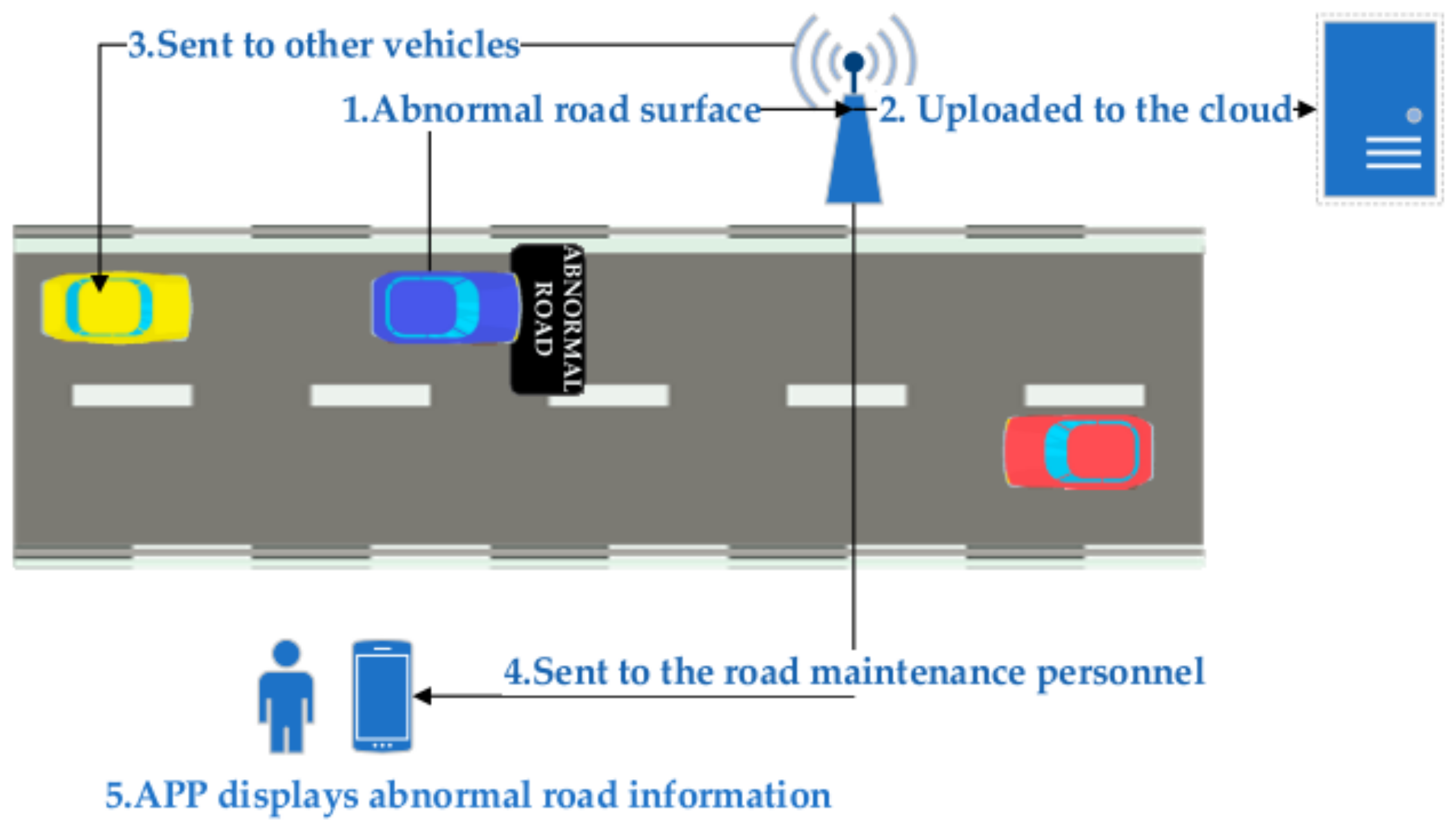
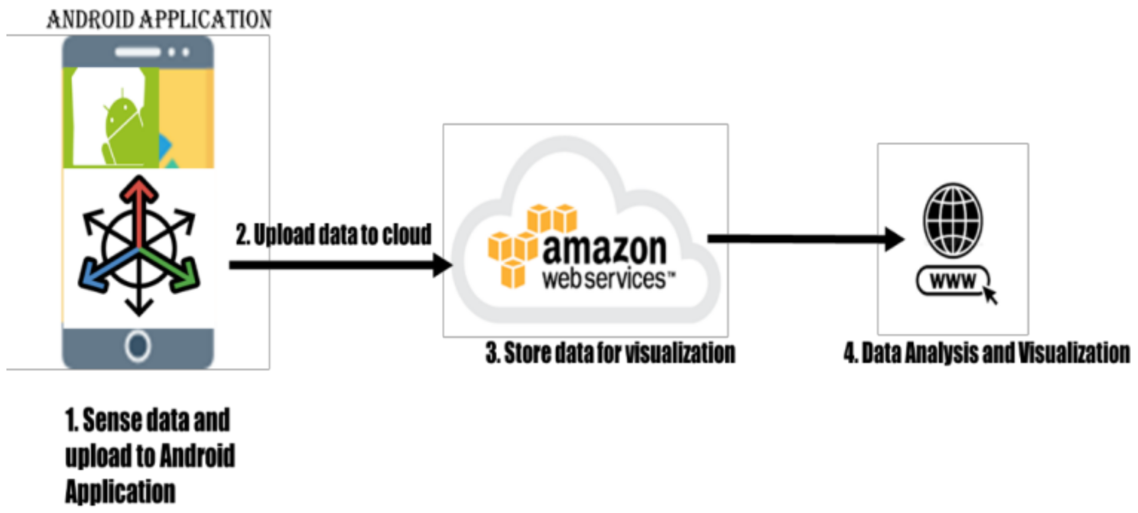
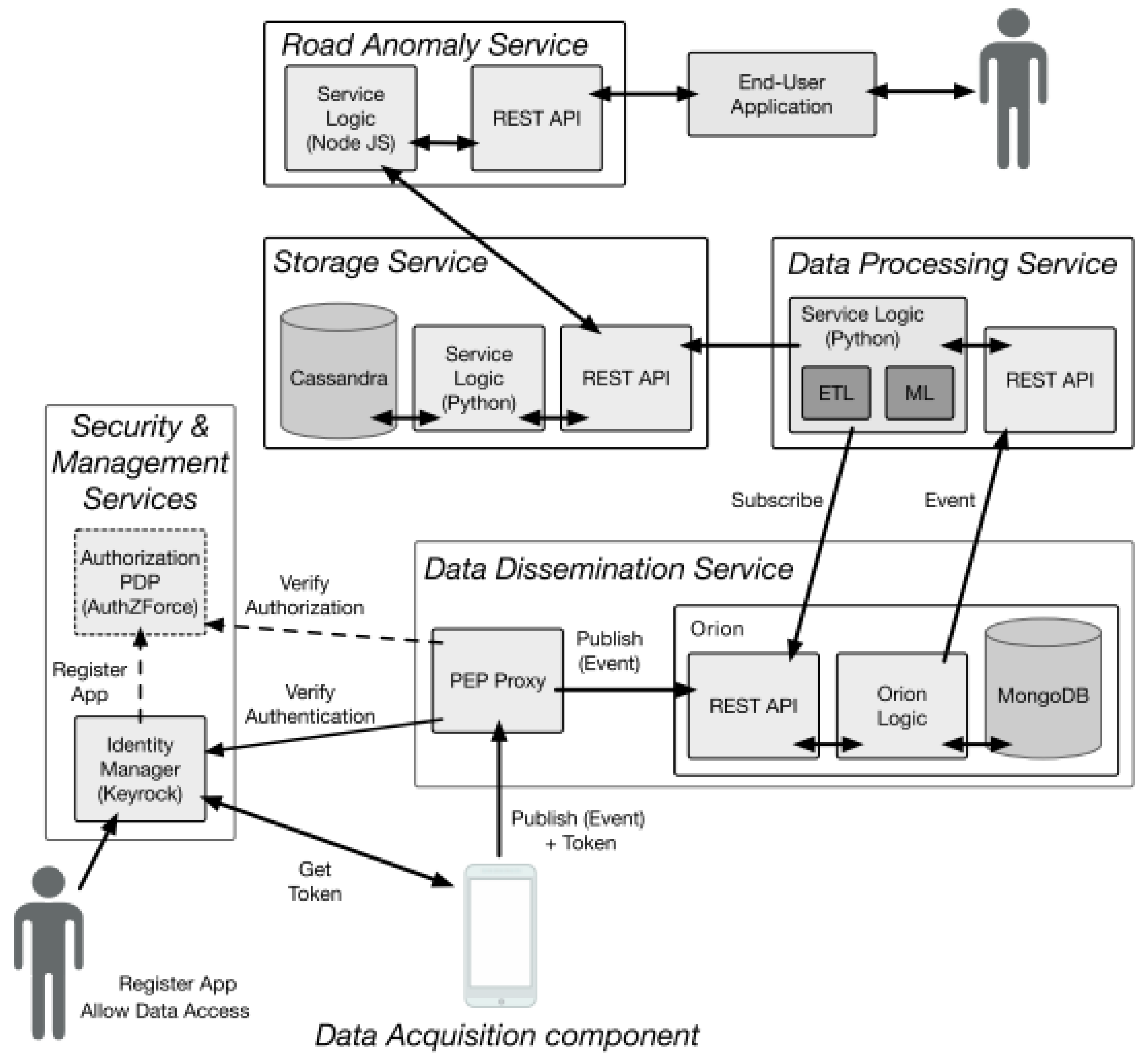
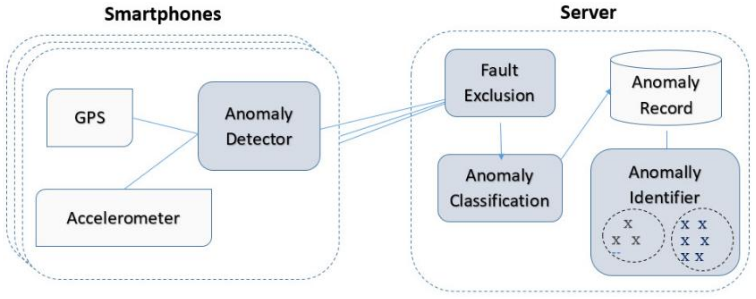
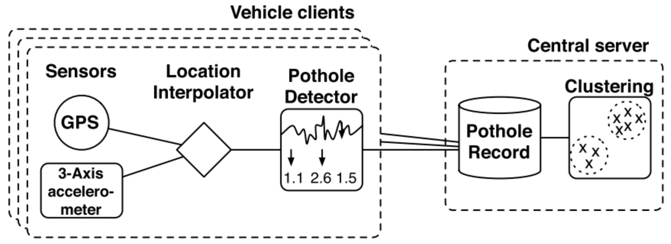
2. Previous Road Health Assessment Systems

Different researchers have already made various attempts worldwide to assist the decision-makers in prioritizing the road sections and analyzing the road health condition. The key models and their essential features are discussed in the following section.
Ronghua et al. [2] collected road surface data using existing cellular network technology, and the proposed model by this study is illustrated in Figure 1.
The latitude and longitude coordinates of the vehicle, traveling speed, and vibration acceleration data of the car are obtained using a smartphone with an acceleration sensor and a GPS module mounted on the vehicle. The smartphone will upload the position and any kind of irregular road surface to the cloud when the vehicle passes over it. The aberrant road data is forwarded to the road maintenance team. When other vehicles approach an irregular road surface, the cloud will issue an abnormal road surface reminder to guarantee that the vehicle may safely and smoothly drive through the area. The system is simply dependent on a single phone setting and uses raw accelerometer measurements, which can record erratic driving or quick brakes, leading to false positives. Because the application has no buffer, data will be lost if the internet goes down. Whereas Pawar et al. [21] proposed a basic system architecture with four tasks: sensing, storing, processing, and retrieving data, as shown in Figure 2.
The data in this system are collected from the mobile phone sensor in the first phase. In the second phase, it uploads the collected data to the cloud. In the third phase, it analyzes cloud data to forecast road conditions. In the final phase, it retrieves the information and plots the road’s condition on the map. The system focused on accelerometer reading as raw and uploaded the data on the cloud. Later, the data are checked, but the raw data will result in false positives without using the filters. Secondly, a mechanism must be defined to save the data if the cloud network stays unavailable with the proposed application.
Khangetal [22] proposes a client–server architecture for using sensors on smartphones to detect traffic anomalies. The three primary phases for the discovery of anomalies are Anomaly Detector, Fault Exclusion, and Anomaly Classification. The detection process is broken down into numerous parts. This enables proper processing distribution between the clients and the server. The distinct components are shown in Figure 3.
The anomaly detector is the component of the smartphone that first identifies potholes. On the phone, a resident program is installed to read data from the accelerometer and GPS sensor. The anomaly detection component receives these data. When the software connects, it sends abnormalities to the server. The exclusion component tries to eliminate false anomalies when the smartphone user is in motion, such as when a brake is applied. The component that classifies anomalies distinguishes between potholes and bumps. To reliably find potholes, the anomaly identifier combines and integrates data from a variety of sources. This technique considers movement discrimination and a few specific defect types, but it requires a complete presence of a person as there are no visual or other sensors involved for validity. Bidgoli et al. [23] also proposed a road roughness monitoring system as shown in Figure 4.
Data were collected using a computer program created in the Arduino programming software combined with code written in the LabVIEW software utilizing the I2C communication protocol after the RRMS was equipped with two accelerometer modules and a microcontroller board. It also needs trained experts to operate the system.
A system based on tire/road noise, microphones, and cepstral signal processing has been proposed, as shown in Figure 5 by [24].
The pavement macrotexture is one of the key inputs to pavement management systems, and it plays a significant influence in tire/road noise interaction noise. In this study, a gadget centered on the vibration mechanism was devised and built. The vibration mechanism is most affected by macrotexture. The speed constraint of 30 km/h (due to the danger of powdering at high speeds) and the data collection to a consistent ambient state are two of the study’s limitations. Furthermore, the examined surfaces were restricted to densely graded surfaces, and no other pavement type was considered. The system does not seem robust as it relies on error-prone sensors and can result in inaccurate data. It does not include acceleration data and may result in various false negatives. The system requires rigorous testing to validate the results.
A mobile-based application for the low-cost pavement health detection system, as shown in Figure 6, was proposed by [25].
The pavement detection model purely relies on human data and cannot be validated if there are errors and may be based on variable judgments leading to wrong results.
An application model based on Android, with scalability and auto data recording, as shown in Figure 7 is proposed by [4].
The data are collected at specific intervals and start recording data. The application is based on two packages storage and data services. The data dissemination services are also services available for sending the data. The technique is efficient in terms of design but does not show how the data is moved and detected. Secondly, the manual entries of information will result in false positives.
A road condition detecting system based on an arduino-based sensing module and an Android smartphone as shown in Figure 8 by [26].
There are two modules where GPS sensors get the data and record the data in raw records. It has the Arduino and the Android parts, which communicate by passing data serially using a Bluetooth module. The data are then stored into an SD card through Bluetooth. There are no details about how to process the data and what sort of data is stored. Moreover, the system does not seem robust to handle actual roads.
A smartphone device to collect, process, and distribute data, as shown in Figure 9, was proposed by [7].
The study focused on detecting and classifying road surface events to track the state and deterioration of road segments in real time. The data contain three sensor elements using high pass filters, but it does not include details about how the transformation filters will work. The data transformation also does not include how the three data will combine, and thus no relationship will result in the wrong tagine.
An automated measurement and data processing chain by IFSTTAR is proposed by the MIRANDA system [27]. This system ensures a series of five functions, as shown in Figure 10.
The MIRANDA system, an automated measurement chain for longitudinal evenness monitoring, was created by IFSTTAR using a technology based on the usage of probe vehicles outfitted with low-cost sensors (the kind that comes with a smartphone). This technique offers the same technique for storing the data as previous techniques, and thus it may result in missing data and even false positives.
P2 system’s architecture and sensors-based approach was proposed by [28]. P2 system consists of a set of sensor-equipped cars and a central server, as shown in Figure 11.
The technique uses multiple records from clients that are using sensors and record the values. Later, the values are integrated with other clients and create a verification of the records. The issues with this technique are that the clients have their own setting, which may result in different values. The clustering approach is practical, but, until the pothole is reported, the vehicles also may get affected.
Every approach has some limitations and each method fits a particular scenario and supports the specific type of defects and road type. Table 1 shows the key features of different existing approaches.
Most of the sensor-based approaches make use of smartphone sensors, but it has yet to be proven whether the number of false-positive will affect the approaches proposed in the literature or not. However, certain technologies that employ dedicated sensors are more accurate in detecting potholes. This section discusses a variety of research topics. The sensors’ measurements are dependent on the vehicle’s speed, how it approached the road irregularity, and the sensor’s position or orientation [30]. It also depends on the vehicle’s suspension system; if the suspension system is not in good working order, sensors will report higher deviation due to the vehicle’s high vibration. A system that considers all scenarios is required.
Benign events: Many phenomena, including expansion joints, train crossings, and door slams, are not considered road abnormalities. These occurrences must be distinguished from potholes. It is necessary to create a system that can adequately classify various events.
GPS error: A location’s longitude and longitude information are provided through GPS. It is used to show users where potholes are located. A 3.3-meter error is obtained [2]. To determine the precise place where the events to be detected happened, this inaccuracy must be minimized. In urban centers with tunnels and tall buildings [8], it is also possible to miss some GPS data. The problem of minimizing the localization error is yet unsolved.
Network overload and delay: The sensor data are to be uploaded on the server at the back-end. If a huge volume of data are sent through the network, network congestion may occur, resulting in data loss or delay. As a result, an application that uses the least amount of network resources is required. It will also reduce the cost of communication.
Privacy: The program requires the device’s location to detect the position of a road anomaly, which can be downloaded by the user, posing a privacy risk. To protect the user’s privacy, an application that can disguise user identification is required.
Machine learning technique: Different vehicles may produce different sensor data for the same pothole. Therefore, machine learning approaches can be used instead of threshold-based classification. It will improve the system’s efficiency and add self-calibration capabilities.

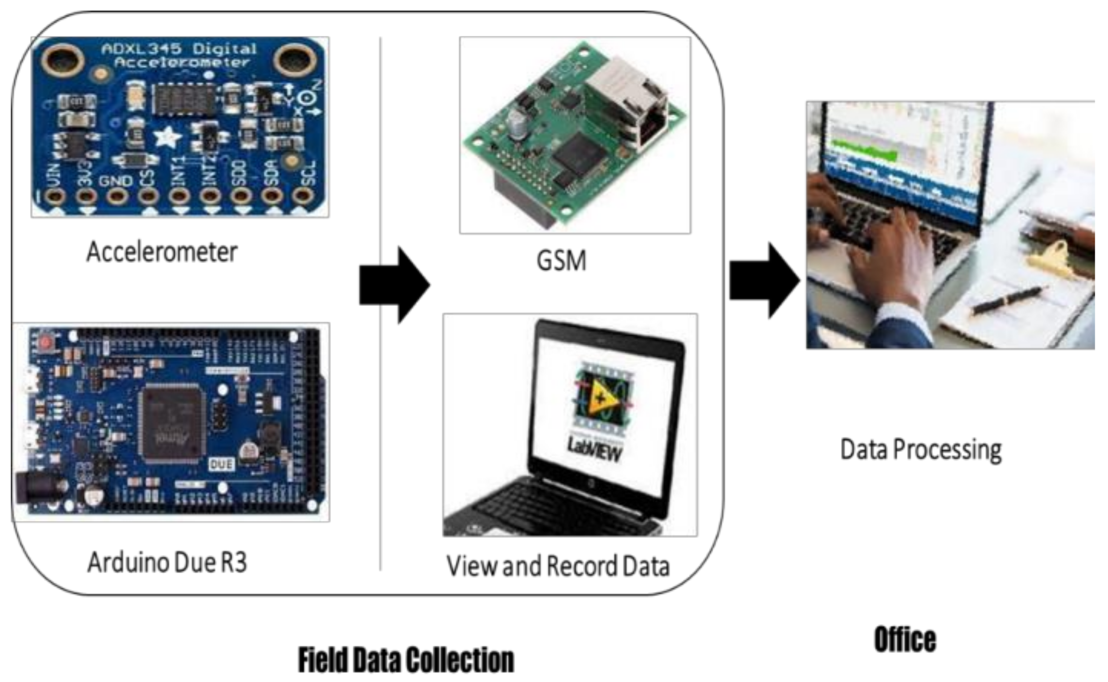
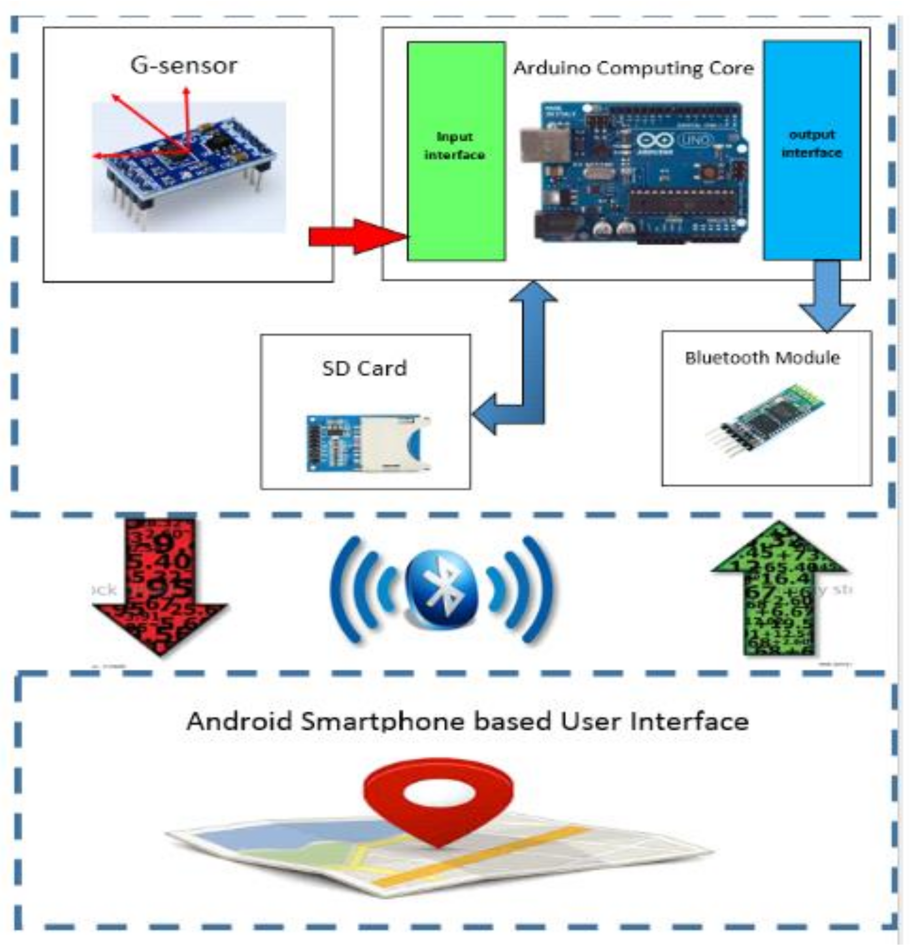
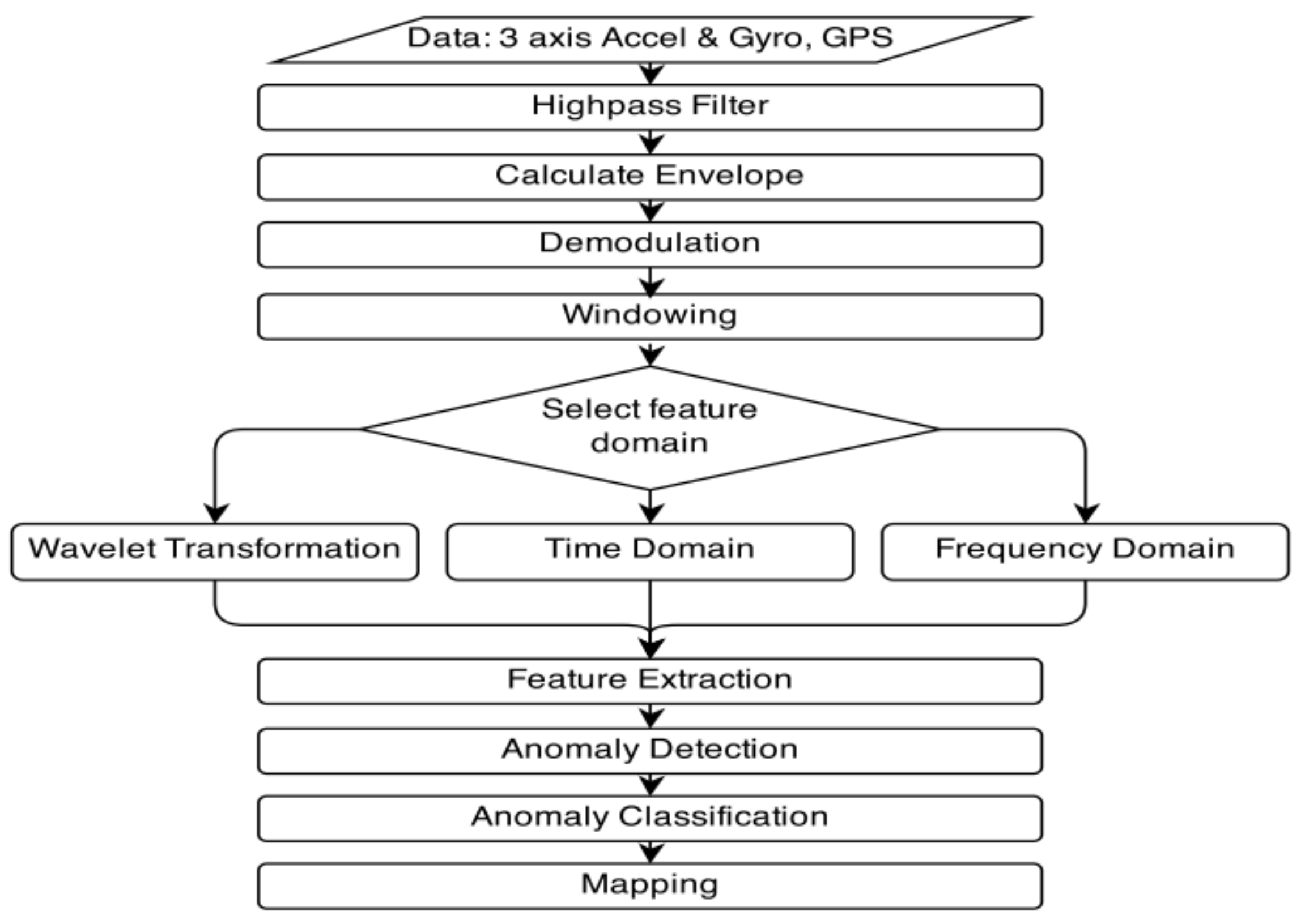
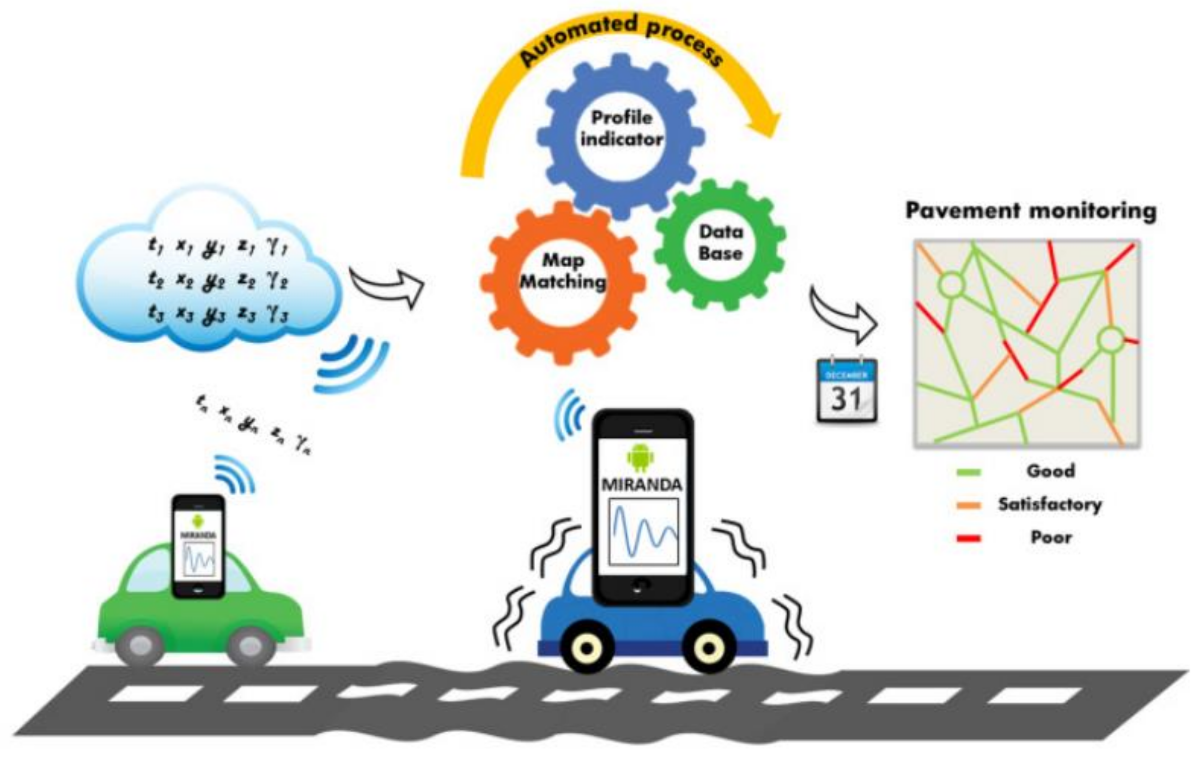
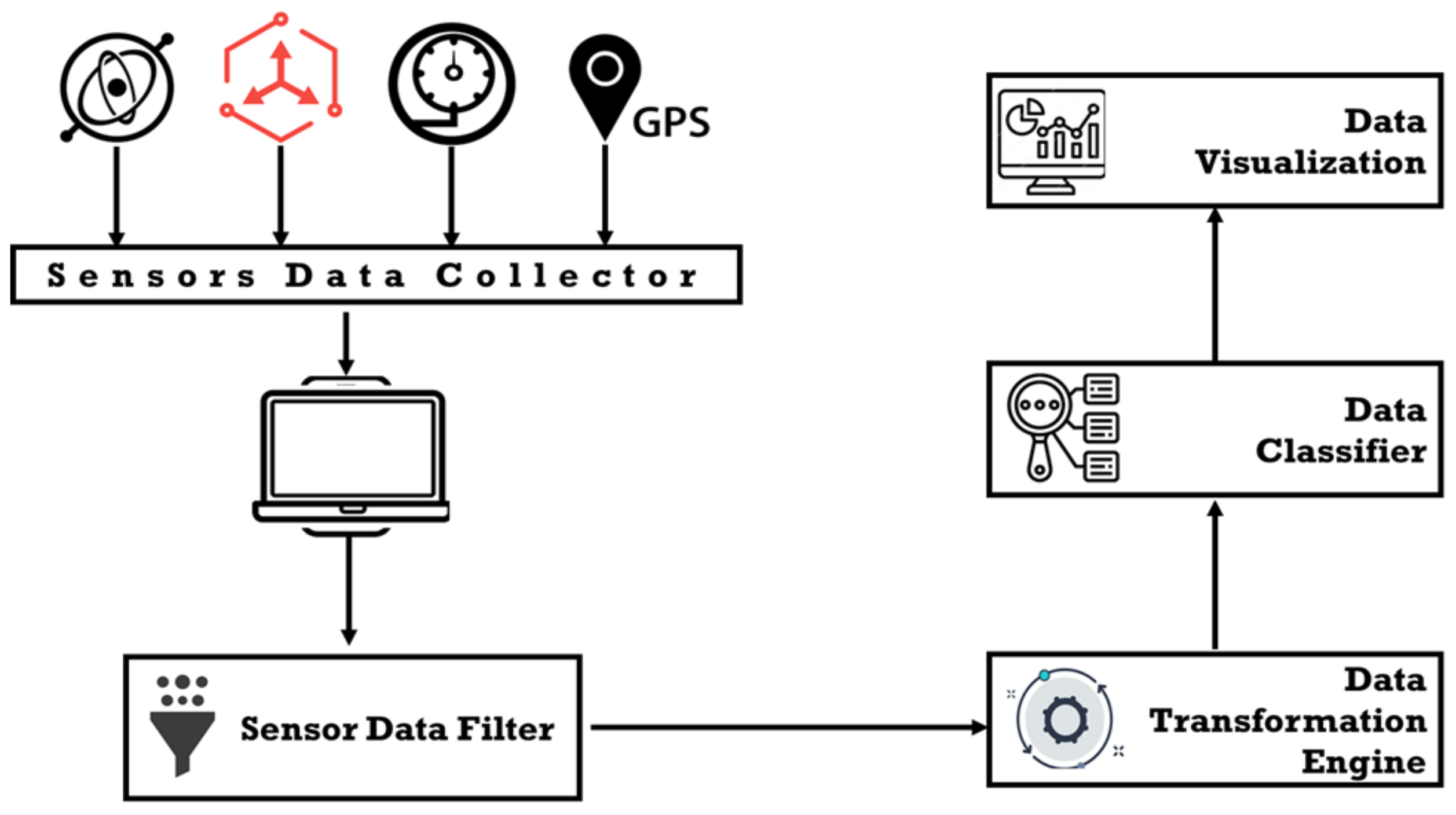
3. Research Methodology

This research adopted the four sensors (1) GPS, also called a Global Positioning System sensor, to find out the location of a device using longitude and latitude. It helped the researcher relate the data to actual map points and helped in the classification of road points; (2) a pressure sensor was also installed in car tires and data were collected using the wireless received whose data were transferred to the computer in the later stage. Timestamps were used to figure out the tire pressure values that were also used to study road quality and tire pressure behavior but are not reflected in this study as very minimal readings were obtained. (3) An IMU or an Inertial measurement unit sensor is a merged value of Gyroscope, Magnetometer, and Accelerometer that allows angular rotation and direction of the moving object. Its values were used compared with accelerometer sensors. The last (4) sensor used was an accelerometer that collects the data to find the object’s position in space and measure its movement. These sensors allow for measuring the position of a moving object at a certain time, allowing this research to determine the relation between sensor values of the quality of the road. The complete model is shown in Figure 12.
A system model divided into six tiers, where the first step is referred to as sensor data collector, is responsible for collecting the data from pressure, accelerometer, GPS, and IMU sensors. The sensors are connected directly to the computer using an USB connection and a small application is designed to collect data from the sensors. In step 3, the data are collected, and we ran the Sensor Data Filter algorithm, a small filtration algorithm designed to remove the noise from the road monitoring data. The data are then forwarded to the Data Transformation Engine, which converts the data into the format used for our classification system. The Data Classifier takes the transformed data and runs the classification algorithm for road quality labeling. The road classification is run through a data visualization algorithm to view the road quality. The classification algorithm was designed based on the parameters’ fluctuations, such as how it has affected the rotation, pitch, and roll. Table 2 shows the classification algorithm ran on a small subset where the classification was made on these three parameters. The associated value of other sensors was used to remove noise while the location of the road section was collected through GPS. Table 2 was designed to show that only the road section with points C and N where C refers to consideration point while N refers to a not considered point as the road was of very good quality.
The reading is collected when there is a no bump and when there is a bump. It is indicated that the acceleration value for both the x and z-axis shows a considerable amount of deflection from the normal threshold. For the categorization of road quality, a detailed classification algorithm was executed to determine the quality of road such as dark green refers to the good quality road, light green refers to good quality with a few movements in a 10-meter area, pink refers to a slightly bad quality road within 10-meter area, and red indicates the poor quality of the road.
Figure 13 shows the event classification based on which this research detected the road condition.
Each pavement defect has a different classification and treatment approach, and its severity levels are also different. This system engages all types of pavement defects, so the system defect reading behavior is also different, as discussed earlier. Figure 14 illustrates the sample example of one defect with reading and without reading the defect.

4. Results and Discussion

The data has been collected for more than 1000 km road sections from Riyadh to Mecca, one of the main Saudi Arabia Road, and it was proposed using the proposed model by this study. The road type was flexible pavement and the data were collected in 2021. Figure 15 shows the classification of road quality using this model.
The results were calculated for consolidated points received within a 10-m area of the subsection; the red color shows that the road was being constructed in that part as classification was also made using visual supervision while collecting the values. Manual visuals helped the researchers to classify in a better way and removal of few noise points such as (1) sensors were detached due to jerks and spikes were recorded, (2) a car was moved to the broken patch or sides or cat-eyes on the road and (3) sudden brakes. The patch of 10 m was selected for consolidated classification to remove the additional noise due to normal fluctuation in the sensor. Thus, the average of 10 m leads the researcher to better reflect on road quality rather than doing it on every point. Initially, the research was done on the consolation of 2, 3, and 5 m, but a large number of points, as well as the difference, were not visible between the initial tested point and 10 m, and it is the sole reason to select the 10-m consolidation. The proposed low-cost automated method is designed to address this challenging problem for the transportation industry. The proposed low-cost approach for road health monitoring using smartphones and sensors can assist the road management authorities with making better planning maintenance schemes. The approach is user-friendly and has better precision.

5. Conclusions

In today’s world, road surface problems have become a source of public concern. Every year, city governments spend millions of dollars to identify, maintain, and repair highways. An adequately maintained road network is vital for the safety and consistency of cars traveling on that road and the health and safety of individuals who travel in such vehicles. It is evident from research that pavement management requires identifying sections that require repairs or overhauling, which is a very costly and time-consuming process. In order to make this process timely and low cost, this research developed a sensor-based cloud application that can help in pavement management. The result shows high accuracy in the detection of road quality in real time. The approach also removes noise that is caused by cat-eyes, sudden brakes, debris on the road, etc. The results are also validated by physical images in few randomly selected sections, and it was observed that the model is presenting 80% accurate results. In the future, the research data can be used to detect road quality in life and thus can help in the early detection of pavement fixing. In the future, a neural network-based scheme can be integrated on collected data so that a prediction can be made about road sections that require fixing before even the actual harm is made.

6. Recommendations and Suggestions

In the future, a fully automated road can help the departments in creating their quarterly and annual plans about the road that require fixing or complete reconstruction. If intelligence can be embedded into it, the system can even inform drivers about managing speed or changing lanes to avoid going through the broken patch. It will result in less carbon emission and lower maintenance costs for the customer and will also avoid accidents. These road monitoring approaches must be complemented with 5D Building Information Modelling (BIM), a drones survey, and a business analytics system. These fully integrated systems will be an integral part of the autonomous vehicular network and can help considerably reduce cost, road accidents, and in-time road repairs effectively.

Author Contributions

Conceptualization, methodology, write up, supervision, funding acquisition, S.H.K.; software, validation, investigation, Y.J.; review, project administration, Z.A.M. All authors have read and agreed to the published version of the manuscript.

Funding

The study is supported by the Research and Initiative Centre (RIC), Prince Sultan University, Saudi Arabia, under the SEED Project Grant No. 20.

Institutional Review Board Statement

Not applicable.

Informed Consent Statement

Not applicable.

Data Availability Statement

The data can be accessed on request from corresponding authors.

Acknowledgments

The authors are thankful to all respondents who supported this study. The study is supported by the Research and Initiative Centre (RIC), Prince Sultan University, Saudi Arabia, under the SEED Project Grant No. 20. The authors are also thankful to RIC and PSU for supporting the APC of this paper.

Conflicts of Interest

The authors declare no conflict of interest.

References

  1. Talpur, M.A.H.; Napiah, M.; Chandio, I.A.; Khahro, S.H. Research Framework Focusing Transportation Accessibility Planning, Computer Based Modeling and Transportation Policy Outlines for Remote Regions of Developing World. Res. J. Environ. Earth Sci. 2013, 5, 32–40. [Google Scholar] [CrossRef]
  2. Du, R.; Qiu, G.; Gao, K.; Hu, L.; Liu, L. Abnormal road surface recognition based on smartphone acceleration sensor. Sensors 2020, 20, 451. [Google Scholar] [CrossRef] [PubMed] [Green Version]
  3. Bello-Salau, H.; Aibinu, A.M.; Onumanyi, A.J.; Ahunsi, S.; Onwuka, E.N.; Dukiya, J.J. Development of a Road Surface Condition Monitoring and Database System. J. Comput. Sci. 2019, 6, 25. [Google Scholar] [CrossRef]
  4. Silva, N.; Shah, V.; Soares, J.; Rodrigues, H. Road anomalies detection system evaluation. Sensors 2018, 18, 1984. [Google Scholar] [CrossRef] [Green Version]
  5. Gawad, S.M.A.; El Mougy, A.; El-Meligy, M.A. Dynamic Mapping of Road Conditions using Smartphone Sensors and Machine Learning Techniques. In Proceedings of the 2016 IEEE 84th Vehicular Technology Conference (VTC-Fall), Montreal, QC, Canada, 18–21 September 2016. [Google Scholar]
  6. Chen, K.; Tan, G.; Lu, M.; Wu, J. CRSM: A practical crowdsourcing-based road surface monitoring system. Wirel. Netw. 2016, 22, 765–779. [Google Scholar] [CrossRef]
  7. Seraj, F.; van der Zwaag, B.J.; Dilo, A.; Luarasi, T.; Havinga, P. Roads: A road pavement monitoring system for anomaly detection using smart phones. Lect. Notes Comput. Sci. 2016, 9546, 128–146. [Google Scholar] [CrossRef] [Green Version]
  8. Khahro, S.; Memon, Z.; Gungat, L.; Yazid, M.; Rahim, A.; Mubaraki, M.; Yusoff, N.M. Low-Cost Pavement Management System for Developing Countries. Sustainability 2021, 13, 5941. [Google Scholar] [CrossRef]
  9. Astarita, V.; Caruso, M.V.; Danieli, G.; Festa, D.C.; Giofrè, V.P.; Iuele, T.; Vaiana, R. A Mobile Application for Road Surface Quality Control: UNIquALroad. Procedia Soc. Behav. Sci. 2012, 54, 1135–1144. [Google Scholar] [CrossRef] [Green Version]
  10. Vittorio, A.; Rosolino, V.; Teresa, I.; Vittoria, C.M.; Vincenzo, P.G.; Francesco, D.M. Automated Sensing System for Monitoring of Road Surface Quality by Mobile Devices. Procedia Soc. Behav. Sci. 2014, 111, 242–251. [Google Scholar] [CrossRef] [Green Version]
  11. Ghose, A.; Biswas, P.; Bhaumik, C.; Sharma, M.; Pal, A.; Jha, A. Road condition monitoring and alert application: Using in-vehicle smartphone as internet-connected sensor. In Proceedings of the 2012 IEEE International Conference on Pervasive Computing and Communications Workshops, Lugano, Switzerland, 19–23 March 2012; pp. 489–491. [Google Scholar] [CrossRef]
  12. Chen, S.Y.; Shih, A.; Hsiao, C.Y. Road conditions detection using Arduino based sensing module and smartphone. In Proceedings of the 2015 IEEE International Conference on Consumer Electronics, Taipei, Taiwan, 6–8 June 2015; 2015; pp. 254–255. [Google Scholar] [CrossRef]
  13. Chugh, G.; Bansal, D.; Sofat, S. Road Condition Detection Using Smartphone Sensors: A Survey. Int. J. Electron. Electr. Eng. 2014, 7, 595–602. [Google Scholar]
  14. Alessandroni, G.; Klopfenstein, L.C.; Delpriori, S.; Dromedari, M.; Luchetti, G.; Paolini, B.D.; Seraghiti, A.; Lattanzi, E.; Freschi, V.; Carini, A.; et al. SmartRoadSense: Collaborative road surface condition monitoring. In Proceedings of the UBICOMM 2014 8th International Conference on Mobile Ubiquitous Computing, Systems, Services and Technologies, Rome, Italy, 24–28 August 2014; 2014; pp. 210–215. [Google Scholar]
  15. Ceylan, H.; Gopalakrishnan, K.; Kim, S.; Taylor, P.C.; Prokudin, M.; Buss, A.F. Highway infrastructure health monitoring using micro-electromechanical sensors and systems (MEMS). J. Civ. Eng. Manag. 2013, 19 (Suppl. S1). [Google Scholar] [CrossRef]
  16. Coenen, A.; Golroo, T.B.J. A review on automated pavement distress detection methods. Cogent Eng. 2017, 4, 1374822. [Google Scholar] [CrossRef]
  17. Xue, W.L.; Wang, D.; Wang, L. A review and perspective about pavement monitoring. Int. J. Pavement Res. Technol. 2012, 5, 295–302. [Google Scholar]
  18. Della Merenda, M.F.G.; Praticò, F.G.; Fedele, R.; Carotenuto, R.; Della Corte, F.G. A real-time decision platform for the management of structures and infrastructures. Electronics 2019, 8, 1180. [Google Scholar] [CrossRef] [Green Version]
  19. Arun Sundaram, S.B.; Ravisankar, K.; Senthil, R.; Parivallal, S. Wireless sensors for structural health monitoring and damage detection techniques. Curr. Sci. 2013, 104, 1496–1505. [Google Scholar]
  20. Talpur, M.A.H.; Napiah, M.; Chandio, I.A.; Qureshi, T.A.; Khahro, S.H. Development of a regional transport policy support system for rural planning agencies in developing world. Procedia Eng. 2014, 77, 2–10. [Google Scholar] [CrossRef] [Green Version]
  21. Pawar, D.; Potdar, R.; Kaul, S.; Pawar, P. Evaluation of Road Condition Using Android Sensors and Cloud Computing. Int. Res. J. Eng. Technol. 2019, 6(2), 1120–1124. [Google Scholar]
  22. van Khang, N.; Renault, E. Cooperative sensing and analysis for a smart pothole detection. In Proceedings of the 2019 15th International Wireless Communications & Mobile Computing Conference (IWCMC), Tangier, Morocco, 24–28 June 2019; pp. 1785–1790. [Google Scholar] [CrossRef]
  23. Bidgoli, M.A.; Golroo, A.; Nadjar, H.S.; Rashidabad, A.G.; Ganji, M.R. Road roughness measurement using a cost-effective sensor-based monitoring system. Autom. Constr. 2019, 104, 140–152. [Google Scholar] [CrossRef]
  24. Ganji, M.R.; Golroo, A.; Sheikhzadeh, H.; Ghelmani, A.; Bidgoli, M.A. Dense-graded asphalt pavement macrotexture measurement using tire/road noise monitoring. Autom. Constr. 2019, 106, 102887. [Google Scholar] [CrossRef]
  25. Edwan, E.; Sarsour, N.; Alatrash, M. Mobile application for bumps detection and warning utilizing smartphone sensors. In Proceedings of the 2019 International Conference on Promising Electronic Technologies (ICPET), Gaza, Palestine, 23–24 October 2019; pp. 50–54. [Google Scholar] [CrossRef]
  26. Rajmane, O.; Rane, V.; Bhosale, A. Road Condition Detection Using Arduino Based Sensing Module and Android Smartphone. Int. J. Adv. Eng. Res. Dev. 2017, 4, 52–57. [Google Scholar] [CrossRef]
  27. Menant, F.; Martin, J.M.; Meignen, D.; Bétaille, D.; Ortiz, M. Using Probe Vehicles for Pavement Monitoring: Experimental Results from Tests Performed on a Road Network. Transp. Res. Procedia 2016, 14, 3013–3020. [Google Scholar] [CrossRef] [Green Version]
  28. Eriksson, J.; Girod, L.; Hull, B.; Newton, R.; Madden, S.; Balakrishnan, H. The Pothole Patrol: Using a mobile sensor network for road surface monitoring. In Proceedings of the MobiSys ’08 6th International Conference on Mobile Systems, Applications, and Services, Breckenridge, CO, USA; 17–20 June 2008; pp. 29–39. [Google Scholar] [CrossRef]
  29. Bernas, M.; Płaczek, B.; Korski, W.; Loska, P.; Smyła, J.; Szymała, P. A survey and comparison of low-cost sensing technologies for road traffic monitoring. Sensors 2018, 18, 3243. [Google Scholar] [CrossRef] [PubMed] [Green Version]
  30. Sapan, B. Road Condition Detection using Commodity Smartphone Sensors Aided with Vehicular Data. Master’s Thesis, University Technology Gothenburg, Gothenburg, Sweden, 2016; pp. 101–105. Available online: http://www.krb.go.ke/road-network/road-conditions.html (accessed on 7 July 2020).
Figure 1. Architecture of a road information sharing system [2].
Sustainability 13 10272 g001
Figure 2. System architecture for road health assessment [21].
Sustainability 13 10272 g002
Figure 3. A smartphone–server system architecture for road health detection [22].
Sustainability 13 10272 g003
Figure 4. Road roughness monitoring system [23].
Sustainability 13 10272 g004
Figure 5. Road health condition assessment model [24].
Sustainability 13 10272 g005
Figure 6. Low-cost pavement health detection system [25].
Sustainability 13 10272 g006
Figure 7. Road abnormality service architecture [4].
Sustainability 13 10272 g007
Figure 8. Road condition detection system [26].
Sustainability 13 10272 g008
Figure 9. Road condition assessment using smartphone devices [7].
Sustainability 13 10272 g009
Figure 10. MIRANDA road monitoring system [27].
Sustainability 13 10272 g010
Figure 11. P2 road monitoring architecture [28].
Sustainability 13 10272 g011
Figure 12. System model for road quality monitoring using low-cost sensors.
Sustainability 13 10272 g012
Figure 13. Detection of various events and their classification.
Sustainability 13 10272 g013
Figure 14. Reading sample (a) with Bum; (b) without Bump.
Sustainability 13 10272 g014
Figure 15. Consolidated road quality over road section.
Sustainability 13 10272 g015
Table 1. Usefulness of sensing technologies [29].
Sensing TechnologyPrinciple of OperationRequirements
CostSmall
Imensions
Energy
Consumption
Easy to
Install
Inductive loopsInductance measurementLowNoHighNo
CamerasImage analysisHighYesHighYes
MagnetometersMagnetic field measurementLowYesLowYes
Acoustic sensorsAcoustic pressure measurementMediumYesLowYes
Radars/LIDARsDetection of reflected electromagnetic waveHighNoHighYes
AccelerometersVibration measurementMediumYesLowYes
Light sensorsLight intensity measurementLowYesLowYes
Passive infrared sensorsInfrared radiation measurementMediumYesLowYes
Ultrasonic sensorsDetection of reflected sounds waveLowNoMediumYes
Wireless communication devicesMeasurement of received signal strengthLowYesMediumYes
Table 2. Attribute set contributing to road classification.
AccelerationRotationPitchCategorizationAccelerationRotationPitchCategorizationAccelerationRotationPitchCategorization
HLEFCLMEFCHLMN
HMEFCLMEFCHMLC
LLEFCLMEFCHMLC
LLEFCLMEFCHMLC
LLEFCMMEFCHLLN
LLEFCMLEFCHLMN
LLEFCMLEFCHMMC
LLEFCMLEFCHLLN
LLEFCMLEFCHLMN
LLEFCLHLNHLLN
LLEFCMHLNHLMN
LLEFCLHLNHMLC
LHLNLHLNHMLC
LLEFCLHLNLEFLC
MLEFCLHLNLHLN
LLEFCLHMNLHLN
LMEFCLHLNLHLN
MLHCLHLNLHMN
LLHCLHMNLHLN
LLHCLHLNLHMN
LLHCMHLNLHLN
LMHCLHLNLHLN
LLHCLHLNMHMN
Publisher’s Note: MDPI stays neutral with regard to jurisdictional claims in published maps and institutional affiliations.

