Abstract
Pedestrian activity is a cornerstone for urban sustainability, with key implications for the environment, public health, social cohesion, and the local economy. Therefore, city planners, urban designers, and decision-makers require tools to predict pedestrian mobility and assess the walkability of existing or planned urban environments. For this purpose, diverse approaches have been used to analyze different inputs such as the street network configuration, density, land use mix, and the location of certain amenities. This paper focuses on the location of urban amenities as key elements for pedestrian flow prediction, and, therefore, for the success of public spaces in terms of the social life of city neighborhoods. Using agent-based modeling (ABM) and land use floor space data, this study builds a pedestrian flow model, which is applied to both existing and planned areas in the inner city of Hamburg, Germany. The pedestrian flows predicted in the planned area inform the ongoing design and planning process. The flows simulated in the existing area are compared against real-world pedestrian activity data for external validation to report the model accuracy. The results show that pedestrian flow intensity correlates to the density and diversity of amenities, among other KPIs. These correlations validate our approach and also quantify it with measurable indicators.
1. Introduction
1.1. Walking Is the Cornerstone of Sustainable Cities
Contemporary urban policies are defining development targets towards resilience, sustainability, walkability, and people-centered approaches. Consequently, pedestrian activity and active mobility modes are becoming one of the main foci in the urban agenda. The ability to walk to places is the cornerstone of urban sustainability, with major impacts on the environment, public health, social cohesion, and the local economy [1]. Sustainability in its multiple realms, i.e., environmental, social, and economic, has been one of the most important topics of political and scientific debate in the last decades. This paper is located in the urban sustainability research area, offering a unique and fundamental contribution to the field of urban simulation. The paper comments on social sustainability and sustainable mobility embedded in the mid-2010s acquis of the UN-Habitat 17 Sustainable Development Goals (SDG) of the 2030 Agenda for sustainable Development—especially SDGs 9 and 11—and the German Advisory Council on Global Change (WBGU), from which the following pieces can be derived:
Firstly, planning mixed-used and walkable neighborhoods fosters environmental sustainability. Carbon emissions derived from motorized mobility, and automobiles in particular, can be reduced by encouraging active mobility modes such as walking. Therefore, fostering accessibility to amenities, services, and economic activities at a walkable distance can be considered an effort towards environmental sustainability. In the context of spatial planning and design, a detailed plan of amenities can be a powerful trigger for pedestrian activity, along with other built environment factors [1].
Secondly, social sustainability relies on inclusion and diversity. The WBGU argues that social inclusion directly relates to “higher levels of satisfaction and more peaceful communities” [2] (p. 31). A cohesive social fabric is generated from inclusive planning—of residents, visitors, workers, business, services, and amenities—at a local neighborhood scale. Consequently, the social fabric is connected to cultural embeddedness. They both are unique and essential characteristics of urban areas. The WBGU calls them “Eigenart” (idiosyncrasy). These characteristics flourish in public space, along with “social networks, trust, security, communication, [and] a shared sense of responsibility” [2] (p. 31). In this context, public space needs to be understood and planned from its potential to both generate and to be activated by flows and encounters of people [3].
In addition to public space, sports and leisure facilities, shops, cafes, bars, and other non-home, non-work third places, as described by Oldenburg [4], become essential conditioners for the establishment of a local sense of place and shared environmental images, playing a key role in the self-construction of urban identities and a cohesive social fabric [5]. The construction of neighborhood identity is strongly influenced by active and lively public spaces, and the supply of activity via the presence of amenities offering goods and services [6]. Consequently, derived socio-economic features condition the construction of everyday practices and define the perceptual characteristics of neighborhoods [7].
Finally, pedestrian flow relates to economic sustainability at the district scale. A steady flow of people to places translates as potential demand for goods and services, and a critical mass of customers to maintain local businesses feasibly. Novel contemporary practices such as e-commerce offer the most cost-efficient way to satisfy basic needs, placing physical consumption closer to socio-symbolic motivations [1,8]. The procedural evolution of the social practices of consumption, and consequently amenities, services, and economic activity, are directly related to the physical transformation of urban spaces [9] and consequently, affect the social fabric and its footprint at the local scale. Close monitoring, understanding, and potentially managing these dynamics is essential in the establishment of livable and cohesive neighborhoods, especially in the context of the development of new urban areas, to ensure and foster socially, ecologically, and economically sustainable urban spaces.
1.2. Literature Review: Walkability Analytics
Acknowledging pedestrian flow as the cornerstone for sustainable localities, which factors might influence pedestrian movement? The literature has identified consistent evidence pointing at urban morphology and land use distribution as the main drivers of pedestrian activity, strongly correlating them.
Space Syntax methodology analyses urban form and the street network from a configurational perspective [10,11,12]. The topological hierarchy of natural streets, among other variables, highly correlates with pedestrian flow volumes and distribution [13]. These variables summarize relevant topological and geometric patterns and develop the idea of natural movement and wayfinding due to visual connections and the topological hierarchy of the underlying living structures [13,14]. This methodology succeeded in identifying the pedestrian “desire lines” of movement, mapping the places with a higher pedestrian demand and the most common pedestrian itineraries.
Within the same theoretical basis, Visibility Graph Analysis (VGA) allows the assessment of urban spaces at a more micro-level [15,16,17]. For VGA developers, Space Syntax representations such as axial lines (straight parts of the street network) and, later, street segments between two consecutive junctions [18] provide a “large” scale representation and quantification of urban spaces, not addressing the on-street human experience appropriately.
Analyzing and quantifying pedestrian-related issues is a challenging endeavor regarding scale [19,20], as the level of detail (pedestrian-scale) limits or is limited by the extent of the sample (local, urban, regional scale). Some authors have analyzed a reduced number of factors per street or for a sample of streets to calculate neighborhood-level summary measures e.g., [21,22]. Others have proposed measures for street segments e.g., [23,24] or each footway e.g., [25]. In contrast, VGA enables a finer granularity (as detailed as required) and, therefore, the analysis of different locations within the same street segment and within the same footway, closer to the human scale of a footstep. This level of detail results in improved correlation coefficients with pedestrian flows measured on-site [13].
Including land-use data and transport node locations into the analysis have the potential to improve the correlation even further [26]. This seems evident as land use density, commercial activities, and public transport nodes are clear pedestrian trip generators [27]. Besides the distribution of retail activities and amenities, consistent studies also suggest the importance of other land-use variables such as population and employment density e.g., [28,29].
While several academics perform comparative studies focusing on pairs of variables (such as street centrality and pedestrian flow volume; street nodes and pedestrian activity level, among others), a comprehensive study including a multi-parametric approach has not yet been conducted. Furthermore, computational street-network approaches such as SpaceSyntax are often applied to data-model-based environments that risk oversimplifying the dynamics of a real-life setting. Therefore, this contribution builds upon the previous research in at intersection of computational street-network analytics and flow, considering several parameters simultaneously. More specifically, we expand on the link between the location of origins-destinations on a given network (in our case: amenities, services, and economic activity), and the quantitative and qualitative characteristics of flow (understood as an aggregation of several individual paths). Moreover, the simulations are compared against real-life empirical measurements.
1.3. Research Objectives
Within this overall investigational scope, this work assesses the role of amenities in enhancing the sustainability of urban spaces through pedestrian mobility and the presence of people in public spaces (urban vitality). As such, we defend that urban vitality and social interaction are matters of immediate concern for urban planners and developers. Applied to the formal process of city-making, knowing the factors that influence the distribution of livable spaces would mean that pedestrian flow could be “intentionally” designed, for instance, by the strategic allocation of amenities, or by aligning the design of the street network to the location of amenities.
Hypothesizing that amenities, retail activities, and services are active motors of social activity in urban and public space, we aim at determining to what extent their key characterizing elements (i.e., density (density is understood as the quantity of elements by the unit of area, is known to be a key condition for urban activeness. Referred to the presence of amenities, a higher density of amenities is related to a higher degree of possibility of action through the supply of goods and services, the satisfaction of basic needs, and to perform leisure and optional activities [30]. It is also related to a higher demand for employees and therefore a higher presence of people) diversity (diversity and heterogeneity of uses and functions foster the mix of people and social interaction [30] by avoiding monofunctional and sectorized areas), and complementarity (complementarity is understood as the capacity of some types of amenities to complete others, creating the possibility of a sequence of actions from the pedestrian perspective e.g., walking from a restaurant to a café instead of having a coffee in the same restaurant where they had lunch. The possibility of sequenced actions is given by complementarity at two different levels [31,32]: functional complementarity, produced when the main function of amenities allows them to become both origin and destination of trips; spatial complementarity, produced as the distance between amenities is walkable)) are related to the configuration of pedestrian flow (i.e., interaction opportunities (opportunities of interaction, in line with the definition of cities as spaces of serendipity [33], which promotes social, cultural, and economic exchange by chance, and it is fertilized by the opportunity to make spontaneous decisions based on the availability of “things to do”—the presence of amenities—and the co-presence with other people in the same location. This is also explored by Stier et al. [34] describing that the “exposure to semi-random social interactions” correlates to mental health indicators), temporal distribution (temporal entropy, is the measure of both the number of trips and the temporal diversity, qualifies the trips as concentrated in a specific time range or spread throughout the day), location and number of pedestrians (pedestrian density is the number of trips that occur per unit of area), time spent outside (duration of the trip is the average length of time that a pedestrian is present in a public space), and distance walked (length of the trip is the average of the aggregated distance that a pedestrian walks)).
1.4. Case Study: New Walkable Districts in Central Hamburg
Located in the inner city of Hamburg, Grasbrook is a future mixed-use waterfront district currently under planning. Its outline is the result of an international urban and landscape design competition held in 2020. The development is expected to be completed by 2040. Built on former harbor land, the maritime and industrial flair is key for the Grasbrook development. The integrated planning process includes landscape and mobility planning, with an ambitious modal split aiming at a 10-min walkable city. The neighborhood is expected to host some locations of national significance, such as the Deutsches Hafenmuseum [35]. To properly connect Grasbrook with neighboring districts has been a central focus throughout the planning process [36], especially to create synergies with the district Veddel to the east [37], and as a link between the northern and southern districts of central Hamburg.
In order to validate the assumptions made to simulate the unbuilt district of Grasbrook, our simulations are also implemented in the neighboring district of HafenCity. Both HafenCity and Grasbrook are very similar in morphology, they are located close to each other at a walkable distance (the construction of a bridge from Grasbrook to HafenCity is being discussed), and they are both inner-city waterfront developments transformed from previous harbor industrial areas. While Grasbrook is currently a brownfield at its Functional Planning phase, HafenCity is half completed and has a current population of approximately 6000 residents as well as visitors and commuters on a daily basis. Therefore, HafenCity provides a suitable comparative case to test the simulation models developed in this research contribution, and compare them against empirical data coming from a close and similar context. The results from the pedestrian simulation models are compared to the data collected from pedestrian-count devices installed in the streets of the west of HafenCity.
The results of the simulations can be the base to assess an integrated Functional Planning phase of development, as decisions about land-use placement can be taken informed by the results of our models. The integrated Functional Planning is prepared on a City-BIM model (CIM) that includes the 3D shape of buildings and public spaces along with land use data (classes and floor areas). The compared scenarios for pedestrian infrastructure and land use distribution result from the planning discussion between city administration and architects. In order to develop a tool that is oriented on highly realistic planning decisions, our simulation scenarios represent several options of “what if”, with a focus on the topics discussed by the Functional Planning stakeholders (e.g., What would happen if we built a bridge connecting Grasbrook with HafenCity?) These options are hereafter referred to as “user inputs”.
2. Materials and Methods
This contribution utilizes agent-based models (ABM) to simulate pedestrian flow. The choice of ABM lies on the focus on an agent scale, in which agents represent individuals, in contrast to network approaches such as SpaceSyntax or VGA where the base entities are streets and street segments. ABM makes it possible to define a set of rules at an individual agent’s level, in order to easily observe upscaled behavior of larger groups. Therefore, it is possible to define a set of routines for one person to follow through one day, and then observe the behavior of the entire neighborhood. Furthermore, the ABM software selected (the GAMA platform) allows multiple data types as input, flexible outputs, and integration in further user interfaces such as dashboards and web applications (see Section 4.3).
2.1. Simulation Area
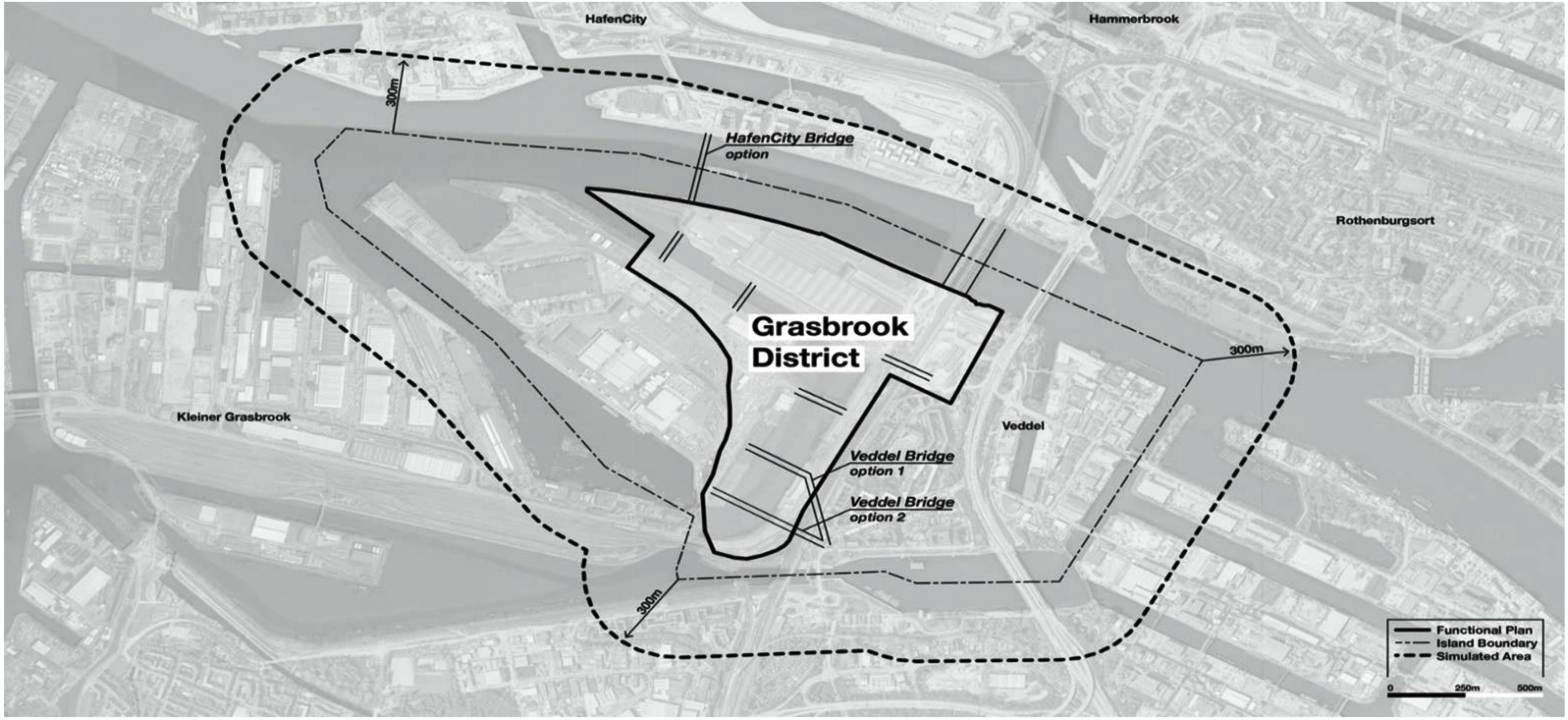
The focus area of the simulation is placed in the planned development of the district Grasbook, including all of the extents of the Functional Plan in development at the time when the simulation is built (November 2020). The new district Grasbrook is characterized by certain isolating conditions: the river Elbe, major traffic arteries, and port industrial areas at west and south. On the east side, however, the district Veddel shares a border with Grasbrook along over one kilometer. Due to the characteristic form of the area, the Grasbrook–Veddel configuration is surrounded by canals, and delimited by the river Elbe at the north. The limits of the simulation are established by those canals and water bodies surrounding the Grasbrook and Veddel districts, plus a walkable offset of 300 m that includes access bridges (Figure 1).
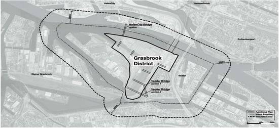
Figure 1.
Description of the boundaries of the simulated area, and the area affected by the Functional Plan. Image source: Authors.
2.2. Synthetic Population
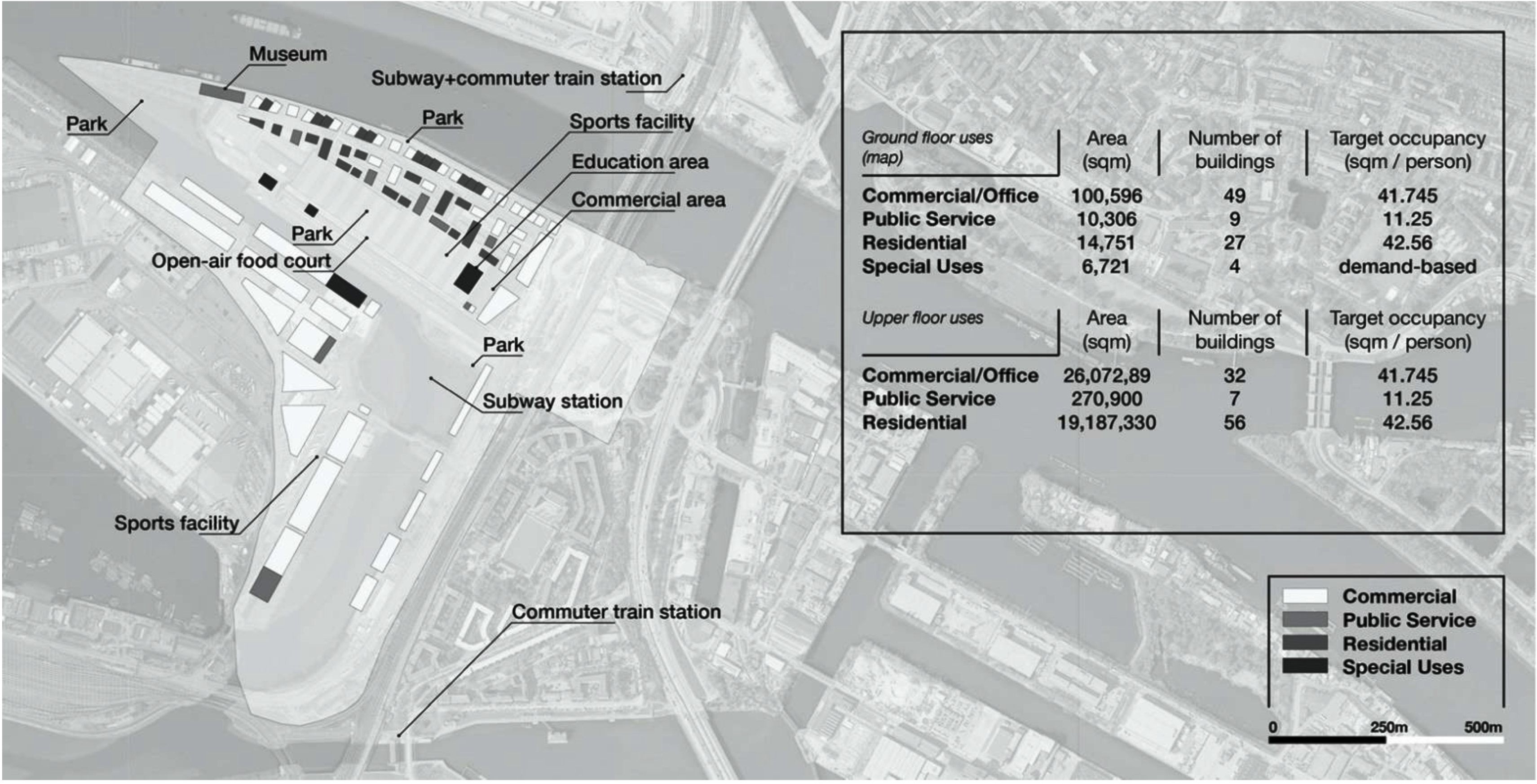
Agent-based models utilized in this contribution simulate the movement of “agents”, which represent people in the neighborhood. These agents are generated as a synthetic population. By cross-referencing the functional classification (land use) with the surface dedicated to each function in the designers’ CIM model, the agent-based model calculates the gross number of “residents” and the number of “employees” from a deterministic-model approach matching target densities given by studies that indicate the area needed per person, on each land use [38,39,40,41] (Figure 2).
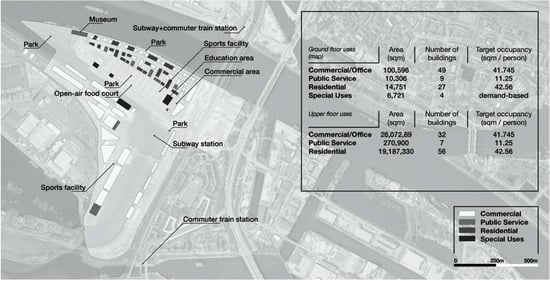
Figure 2.
Description of the input data from the Functional Plan design at the stage of November 2020. Image source: Authors.
From these target amounts, the agent characteristics are assigned from a stochastic-model approach weighted in a probabilistic model with statistical data regarding each of the agent’s internal values. For example, agents are assigned a “workplace”, an “age group”, and a “main transport mode” with reference to the external statistics.
2.3. Simulation Models
To simulate the pedestrian flows of a day in the neighborhood, we define “the everyday” and “the exceptional”. The everyday of each agent is understood as a list of subsequent “things to do” that are conditioned by decision rules, weighted by statistical data (For the case of the Grasbrook, a file containing external statistics is inputted as a data table formatted manually. The table contains information about (a) the probability of a person to pertain to a specific age group, taken from the demographic census of the city of Hamburg [42]; (b) the probability of a resident in the neighborhood to be employed in a place located in a different neighborhood, taken from the designers’ target values; (c) the probability of a worker to be a resident from a different neighborhood, taken from the statistical census “Mobility in Germany” [43]; (d) the modal split of visitors, taken from the statistical census “Mobility in Germany” [43]; (e) the target modal split for residents, taken from the designers’ target values. For the simulation of the comparative case i.e., HafenCity, the external statistics are taken from the sources described above, except for (f) the probability of a resident in the neighborhood to be employed in a place located in a different neighborhood and (g) the modal split for residents, which are both taken from the statistical census “Mobility in Germany” [43]). Due to the high complexity of the simulation, we perform four independent and simultaneous models working with the same inputs and delivering four different outputs that are merged afterward. The representation of the everyday routines is divided into three temporal segments of the simulated day (Models 1 to 3). The simulation of the exceptional is computed on a fourth model running along 24 h of a simulated day, and it represents those activities that are not generally included in everyday routines. Furthermore, these exceptional activities are hosted by buildings classified by the designers as “special-use” in their BIM model, including health-related facilities, public services, religious facilities, community centers, and museums.
2.3.1. First Model—Home to Work
This model simulates the trips to a workplace and the early hours of the morning, from 6 am to 11 am. This simulation model creates a trip for every agent to go from their home origin location to the target location of their workplace or education facility.
2.3.2. Second Model: The Lunch Break
This model simulates the trips from a working place to a lunch facility, from 11 am to 3 pm. At lunchtime, agents generate a series of trips connecting a lunch facility and/or a coffee facility within a radius of walking distance and chosen according to a probabilistic model. After lunch and coffee, the agents walk back to their original workplace.
2.3.3. Third Model: Work to Home
This model simulates a sequence of the trips for each agent, from a working place to other activities and eventually to their home, from 3 pm to midnight. The model “work to home” does not imply that all agents go to their homes directly after work; but they are able to perform leisure, consumption, or service-based activities after their working hours. The decisions whether to perform an activity after work, where to perform it, and how many places they visit are regulated by a probabilistic model.
2.3.4. Fourth Model: Special-Use Amenities
This model simulates the trips to a special-use amenity, during the 24 h of a simulated day. Since this model focuses on the performance of “exceptional” activities which are not part of the everyday, it places special emphasis on the buildings classified with special use. Therefore, this model loads a file containing the demand for special-use amenities i.e., information about the number of visitors going to each special-use amenity every hour to detect the peak demand hours.
2.4. Accuracy of the Models
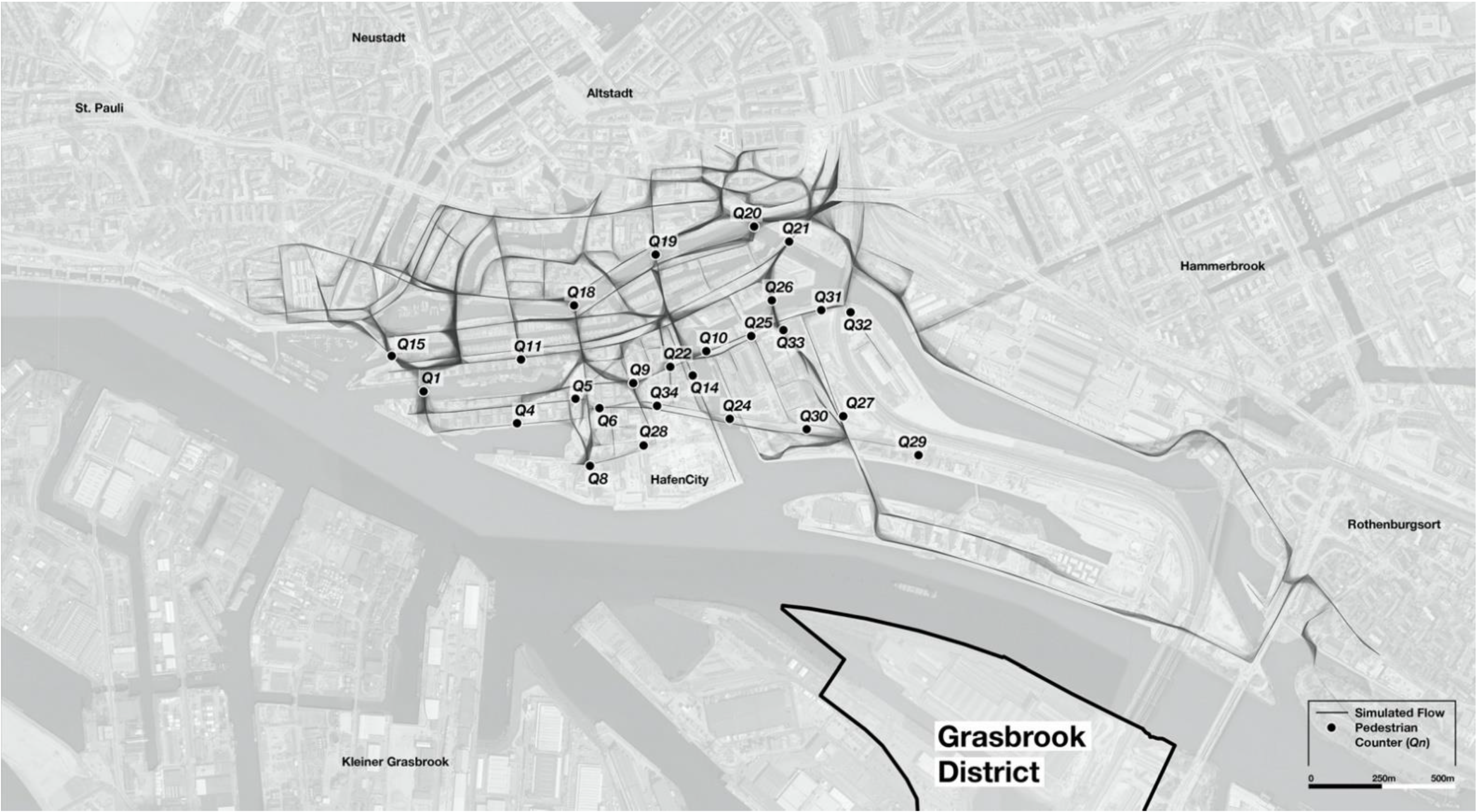
External validation is performed by simulating the district of HafenCity and comparing the simulated pedestrian flow with data obtained from pedestrian volume measurements taken on-site by the transport consultancy ARGUS. More specifically, we compare the flow volume distribution in 19 specific physical locations (Figure 3), where CCTV cameras were placed. These cameras are equipped with anonymization software that allows them to count the number of pedestrians and bikes crossing a virtual line drawn perpendicularly to the sidewalk. This automatic pedestrian counting was performed in 2012, 2016, and 2019. Due to the evolutionary capacity of urban space—the simulation area being majorly under construction in 2012 and 2016—we compare only the latest dataset generated in 2019. Similarly, our simulation model includes a representation of those virtual lines in GIS format in those locations where pedestrians were counted in the real-life setting. The simulation module also counts the number of times that a virtual line has been crossed by an agent, outputting a pedestrian flow volume that can be compared directly with the historical on-site data.
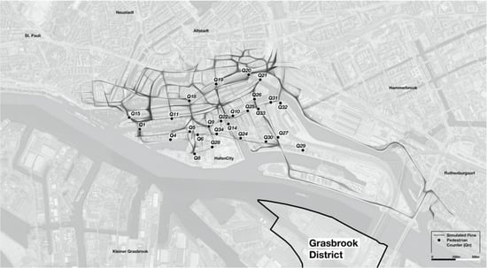
Figure 3.
Location of the pedestrian counter devices in the district of HafenCity (Qn). Image source: Authors.
3. Results
3.1. Simulation Results
An internal evaluation is performed to observe the role of the user input, for each of the characteristics of the pedestrian flow resulting from it (Table 1). This evaluation is performed through Biserial correlation analytics, where correlation is measured from −1 to 1, where −1 means 100% of inverse correlation, 1 stands for 100% direct correlation, and 0 would mean the absence of correlation.

Table 1.
Biserial correlation between scenario options as input (horizontal), and output pedestrian flow (vertical), calculated for all possible user-generated scenarios.
By observing the results depicted in Table 1, it is possible to notice a strong −0.828 inverse correlation between the placement of a bridge in the north-west side of the island and the average length of trips, as the bridge would shorten the connection between the Grasbrook and the southern waterfront of HafenCity, and consequently reduce the trip duration. A −0.73 inverse correlation is also noticeable between the clustering of amenities by function and the temporal entropy of the pedestrian flow, meaning that a higher mix of uses and functions (less functional clustering) favors a temporal diversity in the activeness of space. In other words, functional segregation e.g., placing offices in one cluster, and restaurants in another cluster would favor temporal segregation e.g., office areas only active during working hours, and restaurant areas active only during lunchtime. In the range of the 0.50 correlation, it is observable that the emphasis of locations being put in North-South axis versus East-West axis can have a significant impact on the temporal entropy, and both the length and duration of trips i.e., the time that people spend on public space.
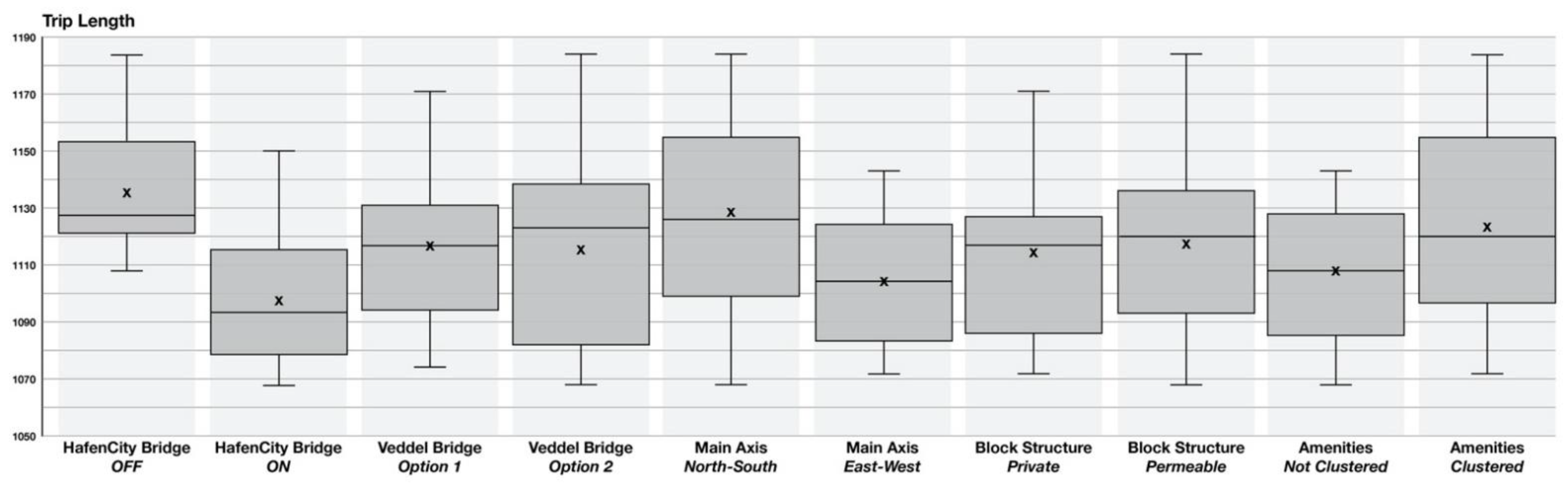
Having a closer look at the effect of specific configuration scenarios for further analysis is possible by using boxplot metrics. These serve as visual representations of the metric value distributions among the various agents. For example, the comparison of the distributions of the trip length among different scenarios can be seen in the following diagram (Figure 4).
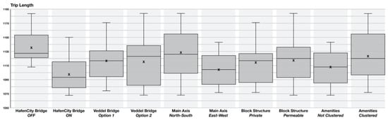
Figure 4.
Boxplots comparing the average trip length distributions among all possible scenarios.
Figure 4 depicts scenarios with the variable “HafenCity Bridge” (including the presence of a bridge connecting to the northern district of HafenCity over the Elbe river, or not including it) making a notorious influence on the values. On average, of all trips across all possible scenarios, the lowest trip length is realized when the bridge to HafenCity is placed. This is especially important for stakeholders to make decisions driven by sustainability goals. Shortening the trip length and duration directly increases accessibility to services and amenities through active mobility modes, and consequently, it can potentially reduce usage and CO2 emissions from motorized transport.
On the contrary, the variable “Veddel Bridge” controls two options for the placement of a bridge connecting to the district of Veddel on the south-eastern side of the Grasbrook development area, each option considering the placement of a bridge as an extension of either the first or the second street east-west-oriented at the south of the Grasbrook. As both options include a bridge in a very similar location, the boxplots corresponding to the two scenarios including the “Veddel Bridge” options in Figure 4 portray the minimum difference in average trip length, as also reported in the Biserial correlation (Table 1) with an inverse correlation of only −0.027.
Regarding the effects of the strategic placement of amenities, the “Orientation of the main axis” offers two possibilities, emphasizing (1) one long street with orientation east-west, versus (2) several shorter streets with orientation north-south. Emphasis is put on placing a higher density of amenities along these street segments. Results show that one-long-street scenarios increase both the duration and length of trips, while several-shorter-streets scenarios accomplish higher temporal entropy (0.568) and more opportunities for social interaction derived from public space encounters (0.317). Similarly, block permeability contributes to this effect and of smaller and denser street segments, as it allows for pedestrians to walk in between the inner courtyards and semi-private spaces. These spaces of smaller size constitute a higher potential for social interaction derived from spatiotemporal encounters (0.315). Furthermore, as pointed out above, not having the amenities clustered by function, type, or use outputs a more diverse and evenly distributed supply of services with increasing the temporal entropy (0.730), the density of people in the streets (0.318), and shortening the trips in distance and time, as more services are accessible.
These observations point in the direction of more socially active spaces in urban fabrics distant from modern and post-modern design patterns with big main streets as structural axis, in favor of smaller, narrower, and denser fabric types, where people perform more and shorter trips and include a variety of use types in a walkable radius.
In sum, correlations between the model inputs (i.e., planners’ and designers’ decisions like the placement of the northern bridge, and general distribution patterns for amenities) show a significant impact on the characteristics of pedestrian flow, meaning that indeed pedestrian flow and activeness of public spaces can be intentionally designed to emphasize certain areas or accomplish certain levels of activity, through strategic placement of amenities and a comprehensive design of the street network. However, two of the variables (i.e., placement of the southern bridges, and block permeability) perform a minimum impact on the pedestrian flow characteristics, probably because (1) our pedestrian agents follow “desire paths” or most efficient routes to reach their destinations (in most of the cases where blocks are permeable, these routes are still following the structure of main streets and therefore, agents do not tend to choose routes that cross through inner courtyards between buildings simply because it would take longer) and (2) the options considered for the bridges at the south of the districts being too similar, with no different outcome in the pedestrian flows generated.
3.2. Principles of Pedestrian Flow
Evaluating the correlation between user inputs and characteristics of the output pedestrian flow shows interesting results that can potentially be applied following the line of thought in which inputs can be adapted i.e., urban space can be modified to accomplish certain levels of pedestrian activity. Besides, it is also possible to evaluate the correlation between the internal characteristics of pedestrian flow by comparing indexes against each other. This comparison can shed light on the characteristics of urban activity related to people walking and being in public space, as already explored by academia since the decade of the 1960s defending that higher density and diversity of amenities would bring people to the streets. However, this claim was observed in real-life settings where the intangible layers of meaning, popularity, perception, or mere routine preferences of pedestrians could not be isolated. We defend that our pedestrian simulation models could be understood as a laboratory experiment where the pure cause and effect relationship can be analyzed quantitatively.
While Table 1 shows a biserial correlation between model/user inputs (planning/design decisions) and resulting pedestrian flow measured in the district Grasbrook as a unit, Table 2 shows a correlation between characteristics of the amenity distribution and pedestrian flow in smaller sub-areas of the district Grasbrook, compared against each other. The Pearson’s correlation coefficient applied to the flow results point towards a 0.435 increment of the temporal entropy with a higher diversity of types of amenities, and a 0.528 increment of pedestrian density by increasing the number of amenities, both reflected in a decrease of both the average trip durations and length—meaning that urban areas could become highly active locally, as people can perform a variety of activities within their walkability radius. Consequently, higher pedestrian density and shorter trips constitute a 0.333 increase in the chances of having social interaction produced by the spatio-temporal encounter between two or more pedestrians in their paths. In other words, correlation results point towards the fact that higher density and diversity of amenities produce a sense of locality that is manifested in pedestrian density activating local centers by walking to close locations throughout several temporal segments of the day.
Table 2.
Correlation between amenities distribution characteristics, and output pedestrian flow, calculated for all sub-divisions (i.e., different areas of the neighborhood).
Interestingly, the complementarity index shows an extraordinarily low correlation to all other indexes. Complementary is understood as a distribution of amenities (restaurant near café or clothing store near shoe store) in which potential destinations of trips are also origins of subsequent trips within a walkable distance. Following this idea, functional and spatial complementarity did not show a correlation to any other indexes. From a data perspective, multiple data sources on activities, uses, and functions implement a layered categorization, e.g., Google Places, Facebook Places, or Foursquare, in which a general type, “Food-related service” can be sub-categorized as “Restaurant” and sub-sub-categorized as “Italian restaurant”. In many cases, complementarity could be established within the context of the main category and different sub-categories, as in “Consumption” types complement each other between sub-categories such as “Clothing store” and “Shoe store” understanding that the “Consumption” sequences often relate several products of apparel. Such sub-categorization is not included in our model, in which only general categories are treated. In consequence, if the diversity index would have accounted for sub-categories, the complementary indexes might have correlated with diversity. The implementation of our pedestrian models aims at informing a Functional Planning phase of a certain district or neighborhood. In that context, the level of detail regarding the definition of sub-categories remains unaddressed by the designers at this stage, meaning that it is neither possible nor useful to determine whether a commercial space shall be used to sell clothing, shoes, or accessories, from a Functional Plan perspective. Therefore, the question on quantifying complementarity tendencies remains open for further studies on consolidated urban areas, or in more advanced stages of urban development planning and operative city management.
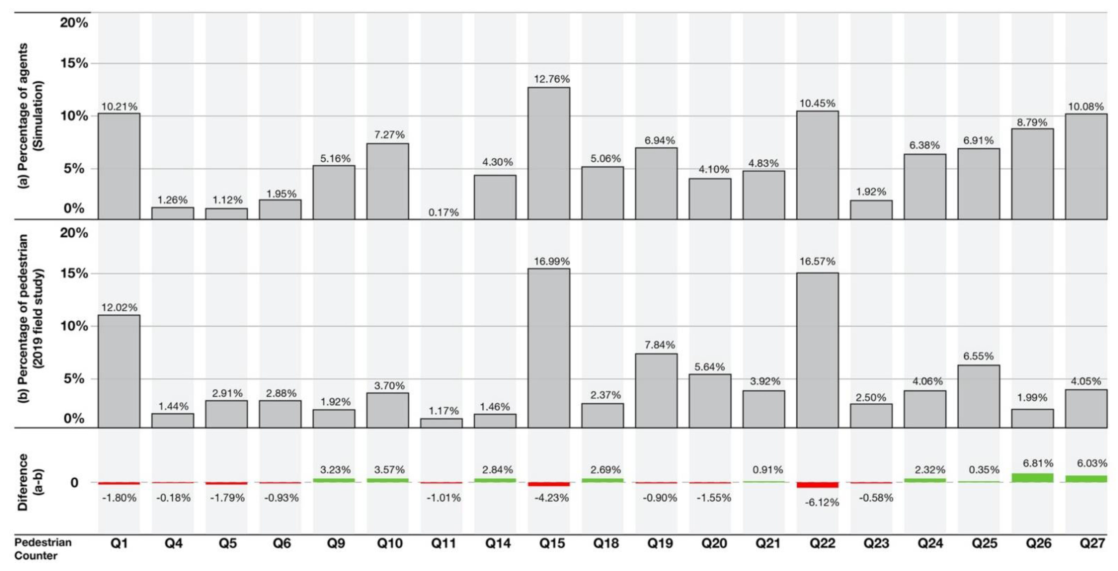
3.3. Model Validation
This evaluation of the model is performed taking the district of HafenCity as a use case, where CCTV cameras were placed in 2019 to automatically count pedestrian volume. Similarly, our model of HafenCity includes a representation of those devices in the same locations, so that empirically counted pedestrian flow volume can be compared directly with the pedestrian flow generated by our simulated agents in the model.
Even though the gross numbers of flow in the simulation and the physical sensors are far away from each other, the relative flow measurements concerning the percentage of flow that is hosted by the street segments that are measured are very similar. In Figure 5 it is possible to observe that the most popular street segments in the simulation models are also those that host the highest level of pedestrian transit reported by the physical sensors, with a maximum deviation of 6.81%.
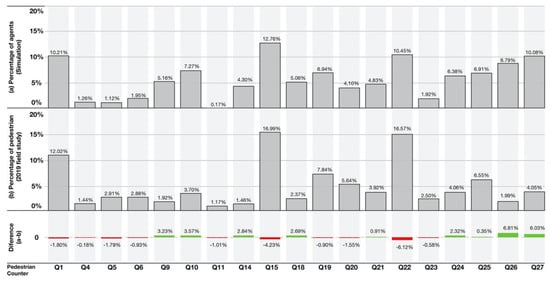
Figure 5.
Distribution of pedestrian flow. Comparison between the percentage of agents simulated (top) and percentage of pedestrians measured in place (center). The resulting difference between both distributions is at the (bottom).
4. Discussion
4.1. Universal Principles and Case-Dependent Results
A question that derives from the aforementioned observations addresses the topic of scalability and replicability of the approach. As the two case studies included in the present research involve two urban areas of similar morphological characteristics and socio-economic context, it is natural to pose the question of whether the same correlations would apply to different city types, namely urban areas with higher levels of integration within the city network, or areas with different sizes and forms. In those cases, it is possible to have a higher inflow of people walking through the neighborhood with an external origin and destination, and, therefore, the placement of amenities at a local level could only affect the local distribution of pedestrian flow, being local and external flows merged and producing different dynamics with different quantitative relations. In those cases, it would be likely to assume that longer trips would tend to approach local centers of activity thus density and diversity of amenities could be correlated directly with trip duration and length. Therefore, to what extent our findings are case-dependent is a question that would be addressed with a broad-scale study on pedestrian mobility tracing citizens through different areas of the city, in several different typological settings.
4.2. Walkability and Rationality
The results portray pedestrian flow resulting from agents designed as rational entities in the neoclassical economic sense [44], meaning that they make choices based on optimization and utility (e.g., choosing the shortest path as the most efficient route). In this sense, specific agent behavior and perception are not considered, as they all behave to follow the same set of procedures rationally. Omer and Jiang [45] proved a high correlation between street centrality and flow, concluding that individuals’ cognition during movement had only a minor influence when compared to topological, angular, and metric measures. Following that approach, we modeled our agents as purely rational entities.
Therefore, one possible criticism of models such as the one presented in this paper might derive from the fact that we are not considering evolutionary Butterfly Economics theory in which individuals are also able to adapt their decision-making based on new information [46] and, therefore, creating an adaptive model in which agents would be able to perform decisions based on a constant evaluation of the environment. Recent research has shown that pedestrians can deviate from the shortest path due to factors like the presence of retail, green areas, or street furniture [47]. Following this line of reasoning, our model outputs a result based on statistics that are utilized as a deterministic probability to the extent that spontaneous decision is limited by the agents as they are able to “decide what to do”—based on an evaluation of the surrounding environment conditioned by the probabilistic choice model that is coded in them—only when they finish performing an action, and they are not able to “change their mind” on the fly. Furthermore, we are not considering the symbolic value of urban spaces in line with the spatial consequences of the “conspicuous leisure” or practices influenced by their socio-symbolic dimension [8,48], such as (1) going to fancy places in order to be seen or showcase status or interact with specific types of people, or (2) performing actions or going to locations in order to refine the “spatial-self” attachment of narratives of places for the construction of a self-identity. We acknowledge the importance of the presence of a flow of people to define spaces of success in the sense that the outcome of our models shall be taken into account when designing new neighborhoods to consider a potential impact in the symbolic layers of urban spaces that host said flow e.g., the potential to create social interaction, social activeness, and to give relevance to specific public spaces to eventually generate landmarks.
The second criticism is related to the main limitation of agent-based models regarding the level of complexity of the simulation performance, i.e., the elements of reality we choose to simulate, and the elements we choose to exclude. We could define the deepest level of reality considering variables with a minor influence on the environment whilst the question regarding “where to place the line” would always be raised. Instead, our model is placed under the “good enough” conditions established by Bourgais et al. [49], in which they state that the level of depth on a simulation including social variables should depend on the level of detail expected in the results, due to the highly challenging nature of the complex and sometimes unpredictable human cognition and behavior. Applied to our case, our main objective is to observe general patterns and major trends in the distribution of pedestrian flow as a comparison of different settings for the logic behind the distribution of amenities. We assumed static environmental conditions across all the scenarios, with the purpose of performing observations of the isolated impact of the distribution of amenities. e.g., since we do not simulate the impact of weather conditions in pedestrian flow, we did not model it.
4.3. The Added Value of Agent-Based Modeling of Pedestrian Flow
In this regard, the results of the simulations included in this paper shall complete the information provided by the performance of purely spatial analyses e.g., Space Syntax computations about connectivity and centrality. Our added value relies on (1) the weight of flow based on population existing target values (2) the emphasis on the description of origins and destinations by the strategic placement of amenities with scenario-based feedback, (3) the observations of the dynamic behavior of flow in time, placing the focus on specific daily routines performed at different times of the day and their progressive evolution, and (4) the probabilistic approach, moving away from fully deterministic approaches.
Furthermore, our integrated KPI dashboard allows, from the user perspective, a horizontal evaluation of the qualitative and quantitative performance of the flow distribution across every scenario allowing the user to compare design options performance and make decisions about the placement and distribution rules of amenities and services (Figure 6). Within the urban project development process, the integrated dashboard assesses stakeholders and designers in iterative design processes such as deliberations on street design and placement of amenities and services.

Figure 6.
Image of the user interface accessible online.
4.4. Further Research
By the beginning of 2021, the simulations described in this paper were being implemented in an open-source interactive online interface that allowed users to select the initial conditions of the street network and placement of amenities to simulate pedestrian flow and measure it through the indexes that are presented in this research. In the near future, our team plans further research in different directions: (1) Interconnection of pedestrian flow simulation with other spatial simulations with a focus on public space e.g., noise comfort and thermal comfort, with the fully interactive placement of amenities and services to feed a real-time simulation embedded on the current user interface, (2) showing the capacity of planned streets and spaces for the projected number of people, including the pedestrian flow/footway width ratio. This feature would be a useful indicator of pedestrian comfort and level of service, as described by Transport for London [50]. (3) The design and documentation of several workshop use-cases to be included in the decision-making the process of the Functional Planning phase of new neighborhoods in the German context, in which the simulation models would be actively utilized to inform about scenario performance and potential intervention impacts. (4) In the near future, we aim to model existing areas with more detailed datasets including socio-behavioral and socio-symbolic inputs in order to overcome the limitations of a neoclassical-economy-driven approach and consequently increasing the level of complexity and improving our consideration of social diversity. Potential data sources include social media and crowd-sourced data.
5. Conclusions
This paper posed the hypothesis that by simulating the pedestrian flow generated by the certain distribution of amenities and streets, during the Functional Planning stages of sustainable area development, the distribution of amenities has the potential to attract people and boost the popularity, livability, and sustainability of new district developments areas by guiding the pedestrian flow to certain areas or emphasizing the locality of certain streets. Especially in the case of having the opportunity to shape a new neighborhood, it might be important to remember a word of warning: “once urban structures and infrastructures are built, you cannot correct mistakes anymore. The future is literally being cast in concrete. Mistakes made in the next two or three decades will haunt many future generations” [2]. Observing the results of the simulation models described in this paper, it is possible to extract conclusions in that direction and avoid lock-in effects.
By using simulation models to inform decision-making processes, it is possible to achieve evidence-based planning in the distribution of amenities with the desired effect on the activity levels of pedestrian flow and pedestrian distribution. Urban and landscape designers, as well as traffic planners, could benefit from such a simulation tool, especially during integrated, temporally compressed, and complex planning processes of sustainable area development projects.
The consequent pedestrian flow produced by the amenities and services follows certain rules, in our two use cases, in which higher density and diversity of amenities tend to produce a higher density of pedestrians walking predominantly on a local scale, potentially producing a higher sense of locality in line with Martí et al. [51] describing urban clusters of social activity following the aggregation of economic activity. The results presented in this research not only validate their approach but also quantify it with measurable indicators.
Author Contributions
Conceptualization, J.L.B., J.S. and A.L.; methodology, J.L.B., J.S. and A.L.; software, J.L.B. and A.L.; validation, M.A.; formal analysis, J.L.B.; investigation, J.S., J.C.-P. and K.B.; resources, P.P.; data curation, A.W.; writing—original draft preparation, J.L.B.; writing—review and editing, J.L.B., J.S., J.R.N., J.C.-P., J.B.-B. and K.B.; visualization, J.L.B.; supervision, J.R.N. and P.P.; project administration, J.S., J.R.N. and P.P.; funding acquisition, J.R.N., P.P. and J.B.-B. All authors have read and agreed to the published version of the manuscript.
Funding
This research has received funding from the city-owned urban development agency HafenCity Hamburg GmbH covering personnel costs, and article processing charges (APC).
Institutional Review Board Statement
Not applicable.
Informed Consent Statement
Not applicable.
Data Availability Statement
Open data utilized as input for the simulations have been cited in the corresponding text sections.
Acknowledgments
Authors appreciate the feedback received by the online tool users.
Conflicts of Interest
The authors declare no conflict of interest.
References
- Carpio Pinedo, J. Spaces of Consumption in the Mobile Metropolis: Symbolic capital, Multi-Accessibility and Spatial Conditions for Social Interaction. Ph.D. Thesis, Escuela Técnica Superior de Arquitectura de Madrid, Universidad Politécnica de Madrid, Madrid, Spain, 2020. [Google Scholar] [CrossRef]
- Messner, D. Normative Compass. D+C Mon. e-Pap. 2016, 201, 29–31. [Google Scholar]
- Carpio-Pinedo, J. Multimodal transport and potential encounters with social difference: A novel approach based on network analysis. J. Urban Aff. 2021, 43, 93–116. [Google Scholar] [CrossRef]
- Oldenburg, R. The Great Good Place: Cafes, Coffee Shops, Bookstores, Bars, Hair Salons, and Other Hangouts at the Heart of a Community, 3rd ed.; Marlowe & Company: New York, NY, USA; Berkeley, CA, USA, 1999; ISBN 978-1-56924-681-8. [Google Scholar]
- Carpio-Pinedo, J.; López-Baeza, J. La producción de identidad de los nuevos desarrollos urbanos a través del place-based social big data: Los crecimientos del área metropolitana de Madrid durante la burbuja inmobiliaria (1990–2012). EURE 2021, 47, 5–28. [Google Scholar] [CrossRef]
- Mehta, V.; Mahato, B. Designing urban parks for inclusion, equity, and diversity. J. Urban Int. Res. Placemaking Urban Sustain. 2020, 1–33. [Google Scholar] [CrossRef]
- Kropf, K. Urban tissue and the character of towns. Urban Des. Int. 1996, 1, 247–263. [Google Scholar] [CrossRef]
- Carpio-Pinedo, J.; Gutiérrez, J. Consumption and Symbolic Capital in the Metropolitan Space: Integrating ‘Old’ Retail Data Sources with Social Big Data. Cities 2020, 106, 102859. [Google Scholar] [CrossRef]
- Karrholm, M. Retailising Space: Architecture, Retail and the Territorialisation of Public Space; Routledge: London, UK; New York, NY, USA, 2016. [Google Scholar]
- Hillier, B.; Hanson, J. The Social Logic of Space; Cambridge University Press: Cambridge, UK, 1989; ISBN 978-1-139-93568-5. [Google Scholar]
- Hillier, B.; Penn, A.; Hanson, J.; Grajewski, T.; Xu, J. Natural movement: Or, configuration and attraction in urban pedestrian movement. Environ. Plan. B Plan. Des. 1993, 20, 29–66. [Google Scholar] [CrossRef] [Green Version]
- Hillier, B. Space Is the Machine: A Configurational Theory of Architecture; Cambridge University Press: Cambridge, UK, 1996; ISBN 978-0-521-56039-9. [Google Scholar]
- Ma, D.; Omer, I.; Osaragi, T.; Sandberg, M.; Jiang, B. Why topology matters in predicting human activities. Environ. Plan. B Urban Anal. City Sci. 2019, 46, 1297–1313. [Google Scholar] [CrossRef]
- Jiang, B.; Ren, Z. Geographic space as a living structure for predicting human activities using big data. Int. J. Geogr. Inf. Sci. 2019, 33, 764–779. [Google Scholar] [CrossRef] [Green Version]
- Desyllas, J.; Duxbury, E. Axial maps and visibility graph analysis. In Proceedings, 3rd International Space Syntax Symposium; Georgia Institute of Technology: Atlanta, GA, USA, 2001; Volume 27, pp. 13–21. Available online: https://citeseerx.ist.psu.edu/viewdoc/download?doi=10.1.1.464.3647&rep=rep1&type=pdf (accessed on 1 May 2021).
- Turner, A.; Doxa, M.; O’sullivan, D.; Penn, A. From isovists to visibility graphs: A methodology for the analysis of architectural space. Environ. Plan. B Plan. Des. 2001, 28, 103–121. [Google Scholar] [CrossRef] [Green Version]
- Turner, A. Analysing the visual dynamics of spatial morphology. Environ. Plan. B Plan. Des. 2003, 30, 657–676. [Google Scholar] [CrossRef] [Green Version]
- Hillier, W.R.G.; Turner, A.; Yang, T.; Park, H. Metric and topo-geometric properties of urban street networks: Some convergencies, divergencies and new results. J. Space Syntax 2010, 1. Available online: https://discovery.ucl.ac.uk/id/eprint/1390423 (accessed on 1 May 2021).
- Ewing, R.; Handy, S. Measuring the unmeasurable: Urban design qualities related to walkability. J. Urban Des. 2009, 14, 65–84. [Google Scholar] [CrossRef]
- Lee, S.; Talen, E. Measuring walkability: A note on auditing methods. J. Urban Des. 2014, 19, 368–388. [Google Scholar] [CrossRef]
- Lamíquiz, P.J.; López-Domínguez, J. Effects of built environment on walking at the neighbourhood scale. A new role for street networks by modelling their configurational accessibility? Transp. Res. Part A Policy Pract. 2015, 74, 148–163. [Google Scholar] [CrossRef] [Green Version]
- Painter, K. The influence of street lighting improvements on crime, fear and pedestrian street use, after dark. Landsc. Urban Plan. 1996, 35, 193–201. [Google Scholar] [CrossRef]
- Clifton, K.J.; Smith, A.D.L.; Rodriguez, D. The development and testing of an audit for the pedestrian environment. Landsc. Urban Plan. 2007, 80, 95–110. [Google Scholar] [CrossRef]
- Foltête, J.C.; Piombini, A. Urban layout, landscape features and pedestrian usage. Landsc. Urban Plan. 2007, 81, 225–234. [Google Scholar] [CrossRef]
- Moura, F.; Cambra, P.; Gonçalves, A.B. Measuring walkability for distinct pedestrian groups with a participatory assessment method: A case study in Lisbon. Landsc. Urban Plan. 2017, 157, 282–296. [Google Scholar] [CrossRef]
- Desyllas, J.; Duxbury, E.; Ward, J.; Smith, A. Pedestrian demand modelling of large cities: An applied example from London. CASA Work. Pap. 2003, 62. Available online: https://discovery.ucl.ac.uk/id/eprint/233/ (accessed on 1 May 2021).
- Ozbil, A.; Peponis, J.; Stone, B. Understanding the link between street connectivity, land use and pedestrian flows. Urban. Des. Int. 2011, 16, 125–141. [Google Scholar] [CrossRef]
- Graham, D.J.; Glaister, S. Spatial variation in road pedestrian casualties: The role of urban scale, density and land-use mix. Urban Stud. 2003, 40, 1591–1607. [Google Scholar] [CrossRef]
- LaScala, E.A.; Gerber, D.; Gruenewald, P.J. Demographic and environmental correlates of pedestrian injury collisions: A spatial analysis. Accid. Anal. Prev. 2000, 32, 651–658. [Google Scholar] [CrossRef]
- Jacobs, J. The Death and Life of Great American Cities; Random House: New York, NY, USA, 1961. [Google Scholar]
- Hess, P.M.; Moudon, A.V.; Logsdon, M.G. Measuring land use patterns for transportation research. Transp. Res. Rec. 2001, 1780, 17–24. [Google Scholar] [CrossRef]
- Carpio-Pinedo, J.; Benito-Moreno, M.; Lamíquiz-Daudén, P.J. Beyond Land Use Mix, Walkable Trips. An Approach Based on Parcel-Level Land Use Data and Network Analysis. J. Maps 2021, 17, 23–30. [Google Scholar] [CrossRef]
- Ascher, F. Diario de un Hipermoderno; Alianza Editorial: Madrid, Spain, 2007. [Google Scholar]
- Stier, A.J.; Schertz, K.E.; Rim, N.W.; Cardenas-Iniguez, C.; Lahey, B.B.; Bettencourt, L.M.; Berman, M.G. Evidence and theory for lower rates of depression in larger US urban areas. Proc. Natl. Acad. Sci. USA 2021, 118, e2022472118. [Google Scholar] [CrossRef]
- Gritti, F. Deutsches Hafenmuseum: Hafenmuseum Eröffnet 2025 am Grasbrook—Wenn Alles Gutgeht. Die Zeit. 2019. Available online: https://www.zeit.de/hamburg/2019-09/deutsches-hafenmuseum-hamburg-eroeffnung-grasbrook-faq?utm_referrer=https%3A%2F%2Fwww.google.com (accessed on 1 May 2021).
- Bruns-Berentelg, J. Stadtteil Grasbrook: Nachhaltigkeit und Mobilität 2019. Available online: https://www.grasbrook.de/2019/02/25/4-grasbrook-werkstatt-am-20-2-2019/ (accessed on 1 May 2021).
- HafenCity Hamburg GmbH. Grasbrook District in Hamburg. 2019. Available online: https://www.grasbrook.de/wp-content/uploads/2020/08/Englisch_Auslobung_Grasbrook_Version_Digital-1.pdf (accessed on 1 May 2021).
- European Commission. Housing Space per Person. 2011. Available online: https://ec.europa.eu/energy/content/housing-space-person_en (accessed on 26 November 2020).
- Bundesanstalt für Arbeitsschutz und Abreitsmedizin (BAuA). Technische Regeln für Arbeitsstätten Raumabmessungen und Bewegungsflächen ASR A1.2; BAuA: Dortmund, Germany, 2018.
- Dähne Verlag. Anzahl der Mitarbeiter pro 1.000 m2 Verkaufsfläche der führenden deutschen Baumarktunternehmen in den Jahren von 2018 und 2019. Statistik Baumarkt + Garten 2020 Deutschland—Österreich—Schweiz; Dähne Verlag: Ettlingen, Germany, 2020; p. 126. [Google Scholar]
- Ulrich, C.; Heckner. Die Richtigen Schritte zur Planung. Tipps & Tricks von U.C. Heckner 2020. Available online: https://www.prisma.ag/fileadmin/thinkfirst/download/tipps_tricks/Die%20richtigen%20Schritte%20zur%20Planung.pdf (accessed on 26 November 2020).
- The Federal Statistical Office. Statistisches Bundesamt 2020. Available online: https://www.destatis.de/EN/Home/_node.html (accessed on 26 November 2020).
- Nobis, C.; Kuhnimhof, T. Mobilität in Deutschland−MiD: Ergebnisbericht Studie von Infas, DLR, IVT Und Infas 360 Im Auftrag Des Bundesministers Für Verkehr Und Digitale Infrastruktur (FE-Nr. 70.904/15); Infas: Bonn, Germany, 2018. [Google Scholar]
- Durlauf, S.; Blume, L.E. The New Palgrave Dictionary of Economics, 2nd ed.; Palgrave Macmillan: London, UK, 2008; ISBN 978-0-333-78676-5. [Google Scholar]
- Omer, I.; Jiang, B. Can cognitive inferences be made from aggregate traffic flow data? Comput. Environ. Urban Syst. 2015, 54, 219–229. [Google Scholar] [CrossRef]
- Ormerod, P. Butterfly Economics: A New General Theory of Economic and Social Behaviour; Faber & Faber: London, UK, 1998; ISBN 978-0-571-20127-3. [Google Scholar]
- Miranda, A.S.; Fan, Z.; Duarte, F.; Ratti, C. Desirable streets: Using deviations in pedestrian trajectories to measure the value of the built environment. Comput. Environ. Urban Syst. 2021, 86, 101563. [Google Scholar] [CrossRef]
- Veblen, T. The Theory of the Leisure Class; Originally Published in 1899; Houghton Mifflin: Boston, MA, USA, 1973. [Google Scholar]
- Bourgais, M.; Taillandier, P.; Vercouter, L.; Adam, C. Emotion Modeling in Social Simulation: A Survey. J. Artif. Soc. Soc. Simul. 2018, 21. [Google Scholar] [CrossRef] [Green Version]
- Transport for London. Pedestrian Comfort Guidance for London 2010. Available online: http://content.tfl.gov.uk/pedestrian-comfort-guidance-technical-guide.pdf (accessed on 1 May 2021).
- Martí, P.; Serrano-Estrada, L.; Nolasco-Cirugeda, A.; López Baeza, J. Revisiting the Spatial Definition of Neighborhood Boundaries: Functional Clusters versus Administrative Neighborhoods. J. Urban. Technol. 2021, in press. [Google Scholar] [CrossRef]

Publisher’s Note: MDPI stays neutral with regard to jurisdictional claims in published maps and institutional affiliations. |
© 2021 by the authors. Licensee MDPI, Basel, Switzerland. This article is an open access article distributed under the terms and conditions of the Creative Commons Attribution (CC BY) license (https://creativecommons.org/licenses/by/4.0/).