Article

Irrigation Supply and Demand, Land Use/Cover Change and Future Projections of Climate, in Indus Basin Irrigation System, Pakistan

1
State Key Laboratory of Hydrology-Water Resources and Hydraulic Engineering, College of Hydrology and Water Resources, Hohai University, Nanjing 210098, China
2
Key Laboratory of Mountain Surface Process and Ecological Regulations, Institute of Mountain Hazards and Environment, Chinese Academy of Sciences, Chengdu 610041, China
3
University of Chinese Academy of Sciences, Beijing 100049, China
4
Project Management Office (PMO) for Punjab Barrages, Rehabilitation & Modernization Projects, Punjab Irrigation Department, Lahore 39571, Pakistan
5
Center of Excellence in Water Resources Engineering, University of Engineering and Technology, Lahore 54890, Pakistan
6
Department of Irrigation and Drainage, University of Agriculture Faisalabad, Faisalabad 38000, Pakistan
7
Department of Agricultural Engineering, Bahauddin Zakariya University, Multan 66000, Pakistan
*
Author to whom correspondence should be addressed.
These authors equally contributed to this study.
Sustainability 2021, 13(16), 8695; https://doi.org/10.3390/su13168695
Submission received: 9 July 2021 / Revised: 26 July 2021 / Accepted: 28 July 2021 / Published: 4 August 2021

Abstract

:
Sustainable management of canal water through optimum water allocation is the need of the modern world due to the rapid rise in water demand and climatic variations. The present research was conducted at the Chaj Doab, Indus Basin Irrigation System (IBIS) of Pakistan, using the WEAP (Water Evaluation and Planning) model. Six different scenarios were developed, and the results showed that the current available surface water is not sufficient to meet crop water demands. The Lower Jhelum Canal (LJC) command area is more sensitive to water scarcity than the Upper Jhelum Canal (UJC). The future (up to 2070) climate change scenarios for RCP 4.5 and 8.5 showed a decrease in catchment reliability up to 26.80 and 26.28% for UJC as well as 27.56 and 27.31% for LJC catchment, respectively. We concluded that scenario 3 (irrigation efficiency improvement through implementation of a high efficiency irrigation system, canal lining, reduction and replacement of high delta crops with low delta crops) was sufficient to reduce the canal water deficit in order to optimize canal water allocation. Improvement in the irrigation system and cropping area should be optimized for efficient canal water management.

1. Introduction

Pakistan’s economy primarily depends on irrigated agriculture, and it uses more than 95% of its total fresh water resources to irrigate 80% of the cultivatable land, which generates 90% of nutrition and fodder [1]. The agriculture sector’s contribution to the GDP of Pakistan is almost 19%, and it provides jobs for 42% of people [2]. Therefore, in Pakistan, water is under stress with susceptible irrigation, and its availability directly influences the socioeconomic situation of the country. An increase in future food demands more water to produce food, but no additional water is available [1]. Globally, water scarcity has risen in preventing plant development as a necessary constraint of the environment in most regions [3,4]. More than 30 countries in arid and semi-arid regions of the world will probably face water scarcity by 2025. As a result, water scarcity will endanger meeting the requirements for foods and fiber, minimize development and increase poverty in rural areas [5].
A significant water shortage in Pakistan has been observed in recent years, and there were 1040 cubic meters per capita water availability in 2010, which could further reduce to 500 cubic meters per capita by 2035 [6]. To fulfill the estimated water demand of 165 billion cubic meters (BCM), Pakistan has to increase its storage capacity by 22 billion cubic meters up to 2025, as predicted by the water sector of Pakistan [7,8]. An inadequate supply of irrigation water to crops is one of the primary reasons for low crop productivity, and it can increase the difference between demand and supply of agricultural production [9]. The inequality of water allocation worsens this trend among water users at the head, middle, and tail reaches of the irrigation canals [10,11]. Similarly, Bandaragoda [12] reported that the irrigation system faces multiple problems such as inequitable water allocation, significant conveyance losses, waterlogging and salinity. Therefore, it is necessary to consider water management alternatives for water demand and supply [3,13,14]. It became a matter of more concern when the number of water users increased and with increased cropping intensities and inequality in allocation, as well as a situation in which water cannot be re-allocated [15].
So far, different models such as CROPWAT (Crop Water and Irrigation Requirement), Two-Source Energy Balance Model [16,17,18,19,20], WARGI–SIM (Water Resources System Optimization aided by Graphical Interface–Simulation) [21], REALM (Resource Allocation Model) [22], AQUATOOL–SimWin (decision support tool for water resources management) [23], MODSIM (Modular Simulator for river basin decision support system) [24], Mike Basin (developed by DHI Mike Series) [25], and WEAP (Water Evaluation and Planning) [26] have been used for the analysis of water demand, water resource systems analysis, water resources planning and management, and water balance and water allocation policies [27]. Therefore, there is a need to use the numerical model by integrated irrigation water management, which provides a detailed understanding of water allocation and maintaining the water balance between supply and demand. The Water Evaluation and Planning (WEAP) model combines the approach related to demand and supply preference to define rules of operation for making water allocations towards demand sites [26,28,29]. The impacts of water allocation management strategies and possible shortages can be determined by performing scenario analysis and simulation of variation in demand and supply variables [26].
Currently, climate change is a reality and has received the attention of researchers across the globe in the past two decades [30,31,32]. Globally, climate change threatens agricultural productivity [33,34]. Pakistan is one of the most threatened countries due to its vulnerable climate [35]. It is predicted that crop production will be profoundly affected by variability in temperature and rainfall in Pakistan [36,37]. Optimization of water allocation is not only necessary to reduce canal water deficits but is also crucial in terms of mitigating climate change impacts [38]. In Pakistan, numerical modeling approaches have rarely adopted the optimization of canal water allocations. Hence, the WEAP model was applied in this study because it not only performs water allocations but also predicts the impact of future climatic variations, which could be helpful in policy reforms for future planning and management of current irrigation water. The research aimed to estimate irrigation water demand based on irrigation water supply and optimize water allocation to the demand sites under multiple scenarios using the WEAP model, and to develop strategies for effective irrigation water utilization under the changing climate.

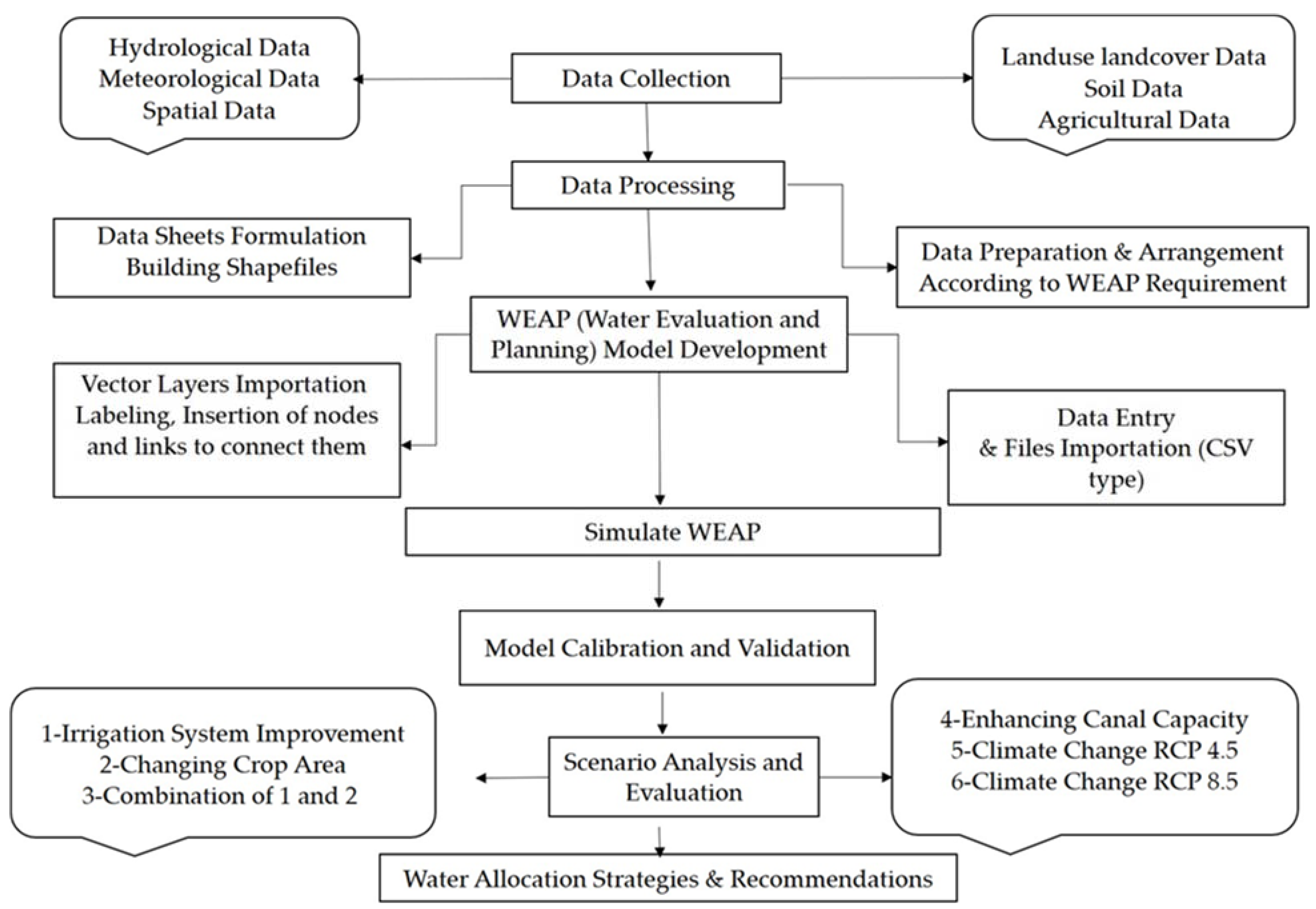
2. Materials and Methods
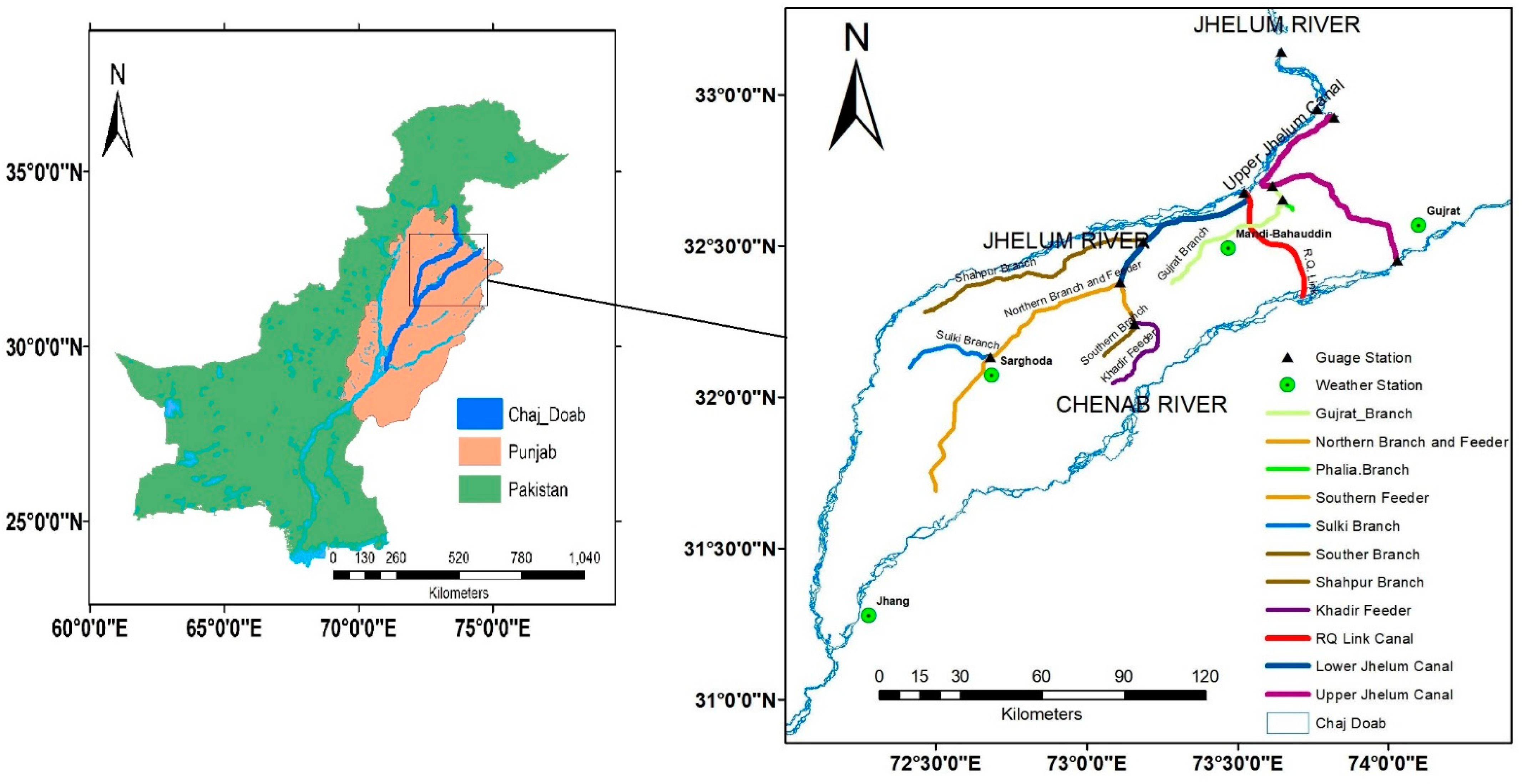
2.1. Study Area

The present study area is bounded by the rivers Jhelum and Chenab, known as Chaj Doab, within the Indus Basin Irrigation System (IBIS) of Pakistan, as shown in Figure 1. It ranges between longitudes 72°10′E to 74°22′E and latitudes 31°11′ N to 32°58′N. The study area altitude varies from 150 to 250 m above mean sea level. The total area of Chaj Doab is 5854 km2, covering four districts, i.e., Gujrat, Mandi Bahauddin, Sargodha, and some parts of Jhang. It has mostly flat topography having overall slope from south to west. The dominant soil type is coarse soil with texture between medium to moderate. Silt and sand with a range from fine to medium are mostly present in the upper 183-m part of the soil named alluvium soils. The northeast area has a semi-humid climate while the southwest has a semiarid climate. The summer in this area is very hot, but the winter season is cool. It has a mean annual temperature of 24 °C, while the range is 3 to 27 °C in winter and very hot weather with 20 to 42 °C temperature in summer. The value of the mean annual rainfall is around 600 mm while the value of reference evapotranspiration (ETref) is around 1600 mm. The monsoon rainfall contributes a large share in total annual precipitation. The irrigation system of Chaj Doab is primarily composed of two main canals, namely Upper Jhelum Canal (UJC) and Lower Jhelum Canal (LJC). Two branch canals, such as Gujrat branch and Phalia, offtake from UJC, while six branch canals offtake from LJC (Shahpur branch, Northern branch and feeder, Southern branch, Southern Sulki branch, and Khadir feeder). Rice, sugarcane, wheat, citrus, and fodder are the main crops grown in this area [39]. CCSM4 (Community Climate System Model Version 4) data provided by IPCC (Intergovernmental Panel on Climate Change) in 5th Assessment report (AR5) were downscaled for RCP4.5 and RCP 8.5 on resolutions of grid size 25 km.
For RCP 4.5 and RCP 8.5, two climatic parameters, i.e., precipitation and rainfall are showing wide variations up to 2070. The mean annual rainfall will decline to around 270 mm and mean annual temp will decrease by 29 °C, respectively both for RCP 4.5 and RCP 8.5.

2.2. Data Collection and Analysis

Several data sets are required to simulate the WEAP model to optimize irrigation water supplies. Table 1 shows the data sets used, i.e., discharge, climate, soil, and land use/cover for eleven years from 2006 to 2016. The detailed summary of input data used to develop the WEAP model is presented in Table 1.
Land use/cover data for Winter (Rabi; October–March) and Summer (Kharif; April–September) seasons were derived from Landsat-8 images. Land use/cover data were also validated by [39]. Figure 2 shows that in Kharif season (2014) the major crops are sugarcane, followed by orchards and rice in Chaj Doab, while wheat, orchards and rainfed are major crops sown in Rabi 2013-14. For kharif season (2014), the percentage crop areas for water, rainfed, sparse vegetation, bare soil, forest area, pastures, fodder, orchards, sugarcane, cotton and rice were 0.45%, 15.11, 0.0061, 0.086, 24.86, 2.60, 2.37%, 16.61%, 16.26%, 17.64%, and 3.99%, respectively. For rabi season (2013-14), the percentage crop areas for wheat, fodder, sugarcane, forest, orchards, rainfed crop, pastures, bare soil and very sparse vegetation were 72.87%, 0.61%, 7.08%, 9.96%, 4.23%, 4.31%, 0.81%, 0.06%, and 0.07%, respectively.

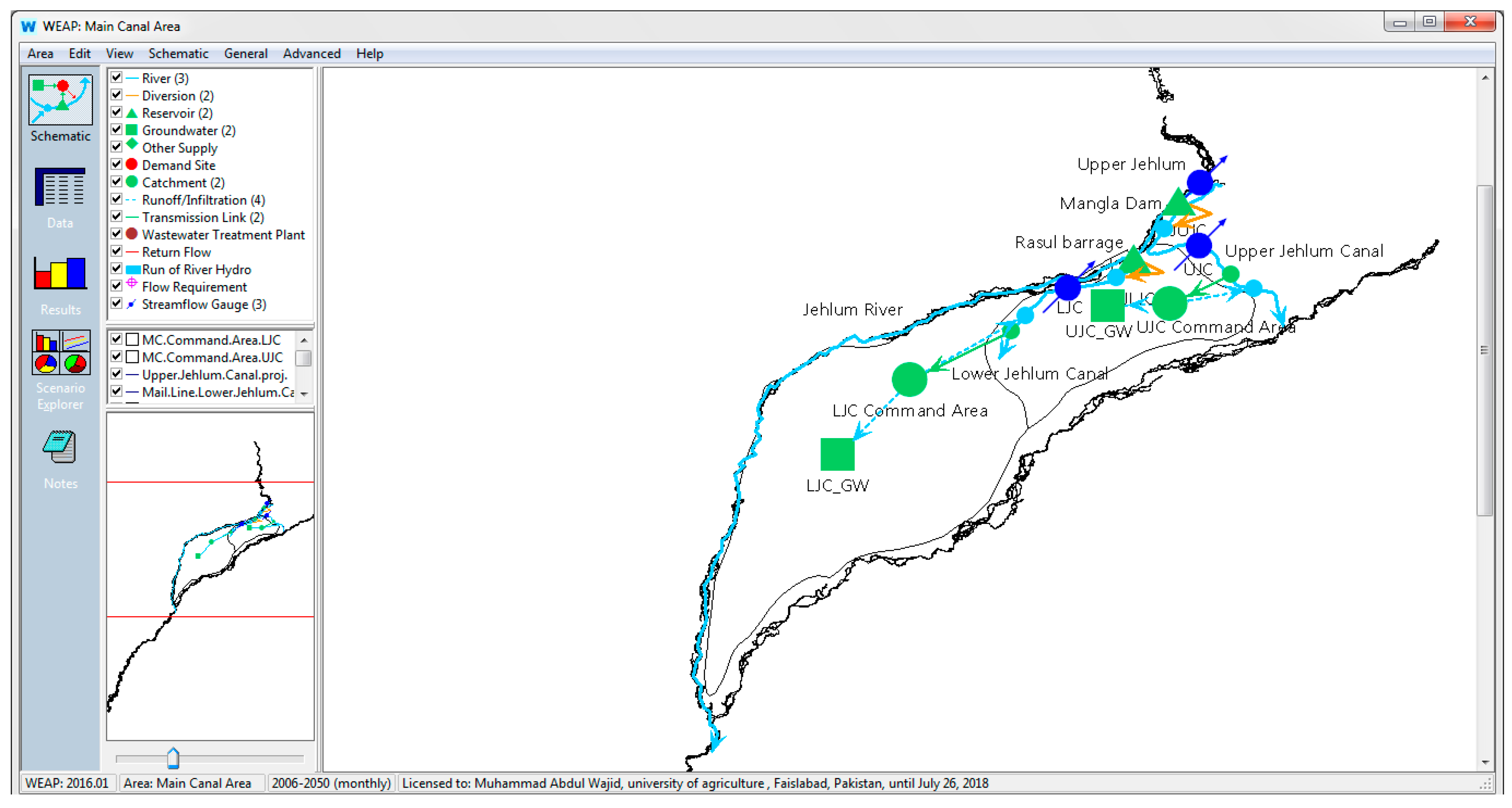
2.3. WEAP Model Development

The Water Evaluation and Planning (WEAP) model developed by Stockholm Environment Institute was used to achieve the research objectives [26]. The WEAP model is used for integrated water resources management and planning strategies that consider the land use/cover, hydrology of the watershed/region, etc. [26]. The WEAP model was used to simulate the impact of various climate changes, land use/cover and irrigation schemes. The WEAP model is used as a tool for modeling, planning, and management of water resources all over the world [41,42,43]. GIS-based shapefiles of the Chaj Doab irrigation system were added into the WEAP model and schematic created to simulate the required objectives as shown in Figure 3.
The WEAP-MABIA method [44,45,46,47] was used for simulation, which involves the daily basis simulation for different parameters, i.e., irrigation water demand, evapotranspiration, crop growth, irrigation scheduling, crop yield, and also elements such as calculation of soil water capacity and reference evapotranspiration. This method uses the dual ‘Kc’ method, where Kc value consists of two components [47,48], including basal crop coefficient (Kcb) and soil evaporation Ke. The formula for actual ETa is given in Equation (1)
E T a = ( K s × K c b + K e ) E T r e f
where ETref is reference evapotranspiration, and Ks is soil stress co-efficient. Total available water or available water capacity can be determined by subtracting a wilting point from field capacity, and it can be represented by the Equation (2) as:
T A W = F . C W . P
where TAW stands for total available water, and W.P is named as a wilting point while F.C represents the field capacity of the soil. For reference evapotranspiration, the following Equation (3) was used:
E T r e f = 0.408 Δ ( R n G ) + γ 900 T m e a n + 273 U 2 ( e s e a ) Δ + γ ( 1 + 0.34 U 2 )
where, ETref represents reference evapotranspiration in mm/day, Rn is a net radiation at the crop surface in MJ/m^2/day, G is the soil heat flux density in MJ/m^2/day which can be ignored (G = 0), Tmean is the mean air temperature with unit in (°C), U 2 represents wind speed at 2 m height in m/s, es shows the saturation vapor pressure in kPa, ea is an actual vapor pressure in kPa, es−ea is the saturation vapor pressure deficit in kPa, Δ is the slope vapor pressure curve measured in kPa/°C, and G is the psychrometric constant in kPa/°C [16]. The detailed research layout is shown in Figure 4.

2.4. Scenarios Developed in WEAP Modeling Framework

WEAP works on what-if type of scenarios and provides a good comparison between reference and future scenarios [26,49,50]. The impact of six different scenarios (Table 2) was tested on unmet demand and reliability of the system against the reference scenario. The current account year was 2006, and it was extended up to 2070 to simulate the reference scenario for the purpose of comparison, analysis and evaluation of other future scenarios. All the scenarios were created under the reference scenario in the WEAP model for comparison with future scenarios. The efficiency of different irrigation systems was considered as follows: drip irrigation efficiency 80–91% and sprinkler 54–80%. In scenario 2, the area of high delta crops was reduced and replaced with crops that have low water requirements. The 50% area of rice crop was reduced while keeping in mind the importance of rice demand, and this percent was added or given to maize, sorghum and very small percent to cotton although it requires much water, but water requirement of cotton is less than rice.
In scenario 4, the canals are operating at less than design discharge because of addition of silt and other debris materials that continuously decrease its capacity. By proper maintenance and silt removal the canal capacity will be increased. Canal capacity is enhanced by increasing diversions from river into the canals, which ultimately results in more water supplies to catchment. The inflows to the canals were increased by allocating 20% more water to the canal from the Jhelum River to use it as an allocation plan. So by allocating more water through diversion, unmet demand could be decreased, but this percent is minute.

2.5. Model Calibration

Nash–Sutcliffe efficiency (NSE) and Percent bias (PBIAS) were calculated using Equations (4) and (5), respectively, for calibration and validation of the model results [51].
N S E = 1     i = 1 n ( Q o Q s ) i 2   / i = 1 n ( Q o Ǭ s ) i 2  
P B I A S = 100   x   (   i = 1 n ( Q o Q s )   / i = 1 n ( Q o ) i )  
where Qo represents observed flow and Qs shows simulated flow, Ǭs is mean of the simulated flow and n is the number of observations.

3. Results

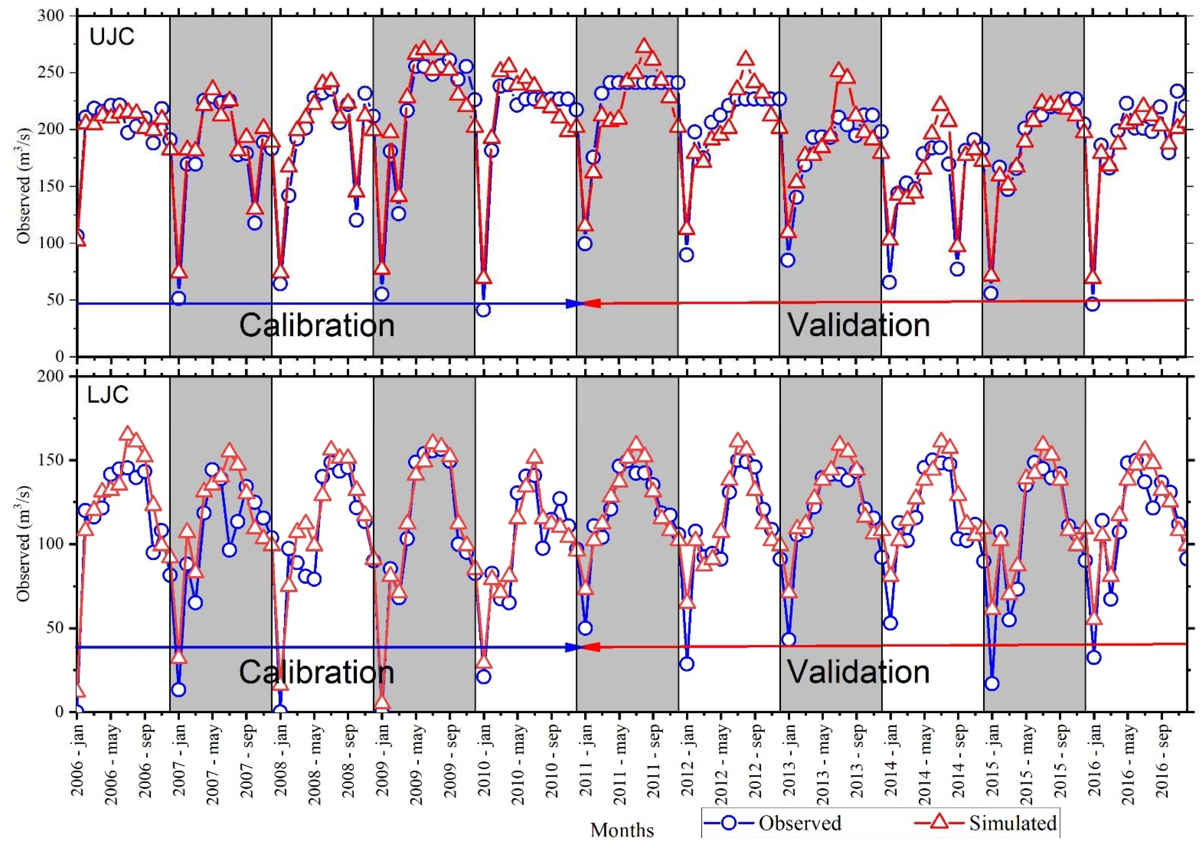
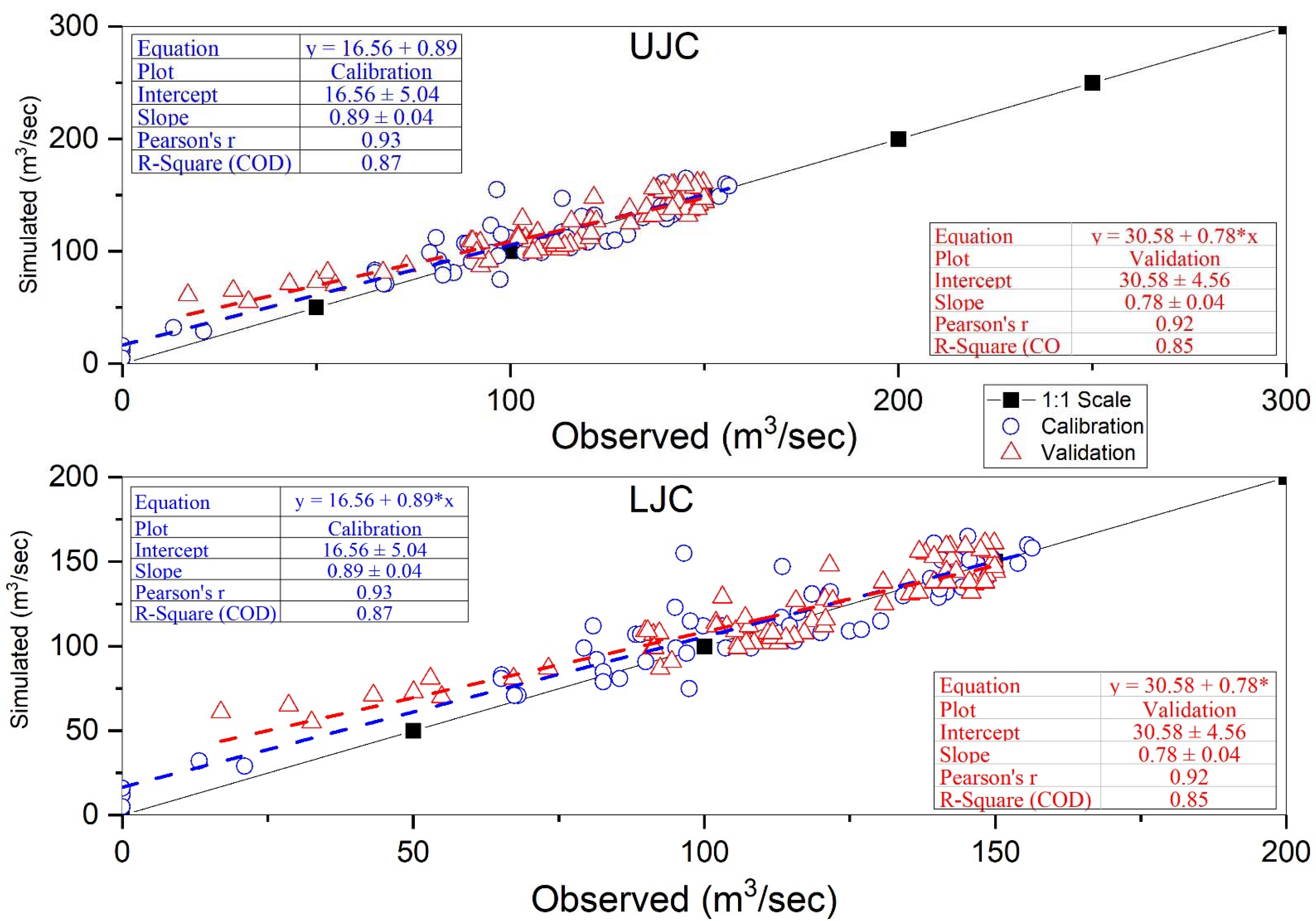
3.1. Simulated and Observed Streamflow

A comparison was made between mean monthly observed and simulated flows from 2006 to 2010 for calibration and 2011 to 2016 for validation. During the calibration period for the Upper Jhelum Canal (UJC), the model shows a close match in January, February, April, August, October and December, while it overestimates in May, July, September and November (Figure 5). On the other hand, the model underestimates the streamflow in March and June. However, for the Lower Jhelum Canal (LJC), the observed and simulated streamflow values are very close during January, April, June and July. The model overestimates during February, May, September, October, November and December, and underestimates during March and August, as shown in Figure 5.
During the validation period for UJC, the model streamflow values are closely matched during January, March, April, October and December, while the model over-estimated in May, July, August and November (Figure 5). For LJC, the validated observed and simulated streamflow values are very close to each other during January, March, April, June and September. The model overestimates stream flows during February, May and October and underestimates stream flows during July, August, November and December, as shown in Figure 5.

3.2. Model Calibration and Validation

The WEAP model was subjected to calibration from years 2006 to 2010 and for validation from 2011 to 2016, as presented in Figure 6. The statistical parameters such as R2, NSE co-efficient, PBIAS were tested to observe model calibration and validation on observed and simulated average monthly streamflow. For calibration of UJC, the monthly values for observed flows (m3/s) from January to December were 52, 145, 157, 192, 205, 199, 201, 186, 189, 172, 197, 178, respectively. While simulated flows (m3/s) from January to December were 60, 150, 139, 199, 221, 182, 215, 186, 205, 179, 214, 183, respectively. For calibration of LJC, the monthly values for observed flows (m3/s) from January to December were 6, 83, 76, 94, 125, 136, 132, 125, 137, 105, 108, 78, respectively. While simulated flows (m3/s) from January to December were 20, 100, 55, 110, 142, 139, 126, 110, 154, 119, 125, 90, respectively. For validation of UJC, the monthly values for observed flows (m3/s) from January to December were 72, 167, 148, 186, 207, 206, 210, 206, 195, 208, 215, 193, respectively. While simulated flows (m3/s) from January to December were 84, 138, 154, 198, 224, 176,231, 218, 177, 216, 229, 200, respectively. For validation of LJC, the monthly values for observed flows (m3/s) from January to December were 51, 91, 75, 113, 127, 138, 158, 147, 141, 97, 128, 95, respectively. While simulated flows (m3/s) from January to December were 37, 108, 84, 104, 134, 144, 144, 134, 133, 110, 111, 80, respectively. The calibration results described that NSE values were 0.91 and 0.83, R2 values were 0.93 and 0.87, and percent bias (PBIAS) values were −2.92 and −7.01 for UJC and LJC, respectively (Table 3). The validation results of NSE, R2 and PBIAS for UJC were 0.80, 0.83, and −1.48, while for LJC, the values were 0.83, 0.85, and −2.97, respectively.
The negative sign indicates that the simulated flow is lower than the observed flow. For the satisfactory performance of the model, the values of PBIAS should be in the range of ±25% in the case of streamflow. NSE should be >0.50, and the range for R2 (0–1), with 1 is an indication of a perfect match between simulated and observed flows and vice versa [51]. The resulted statistical values are clearly showing a good match between the measured and simulated flows.

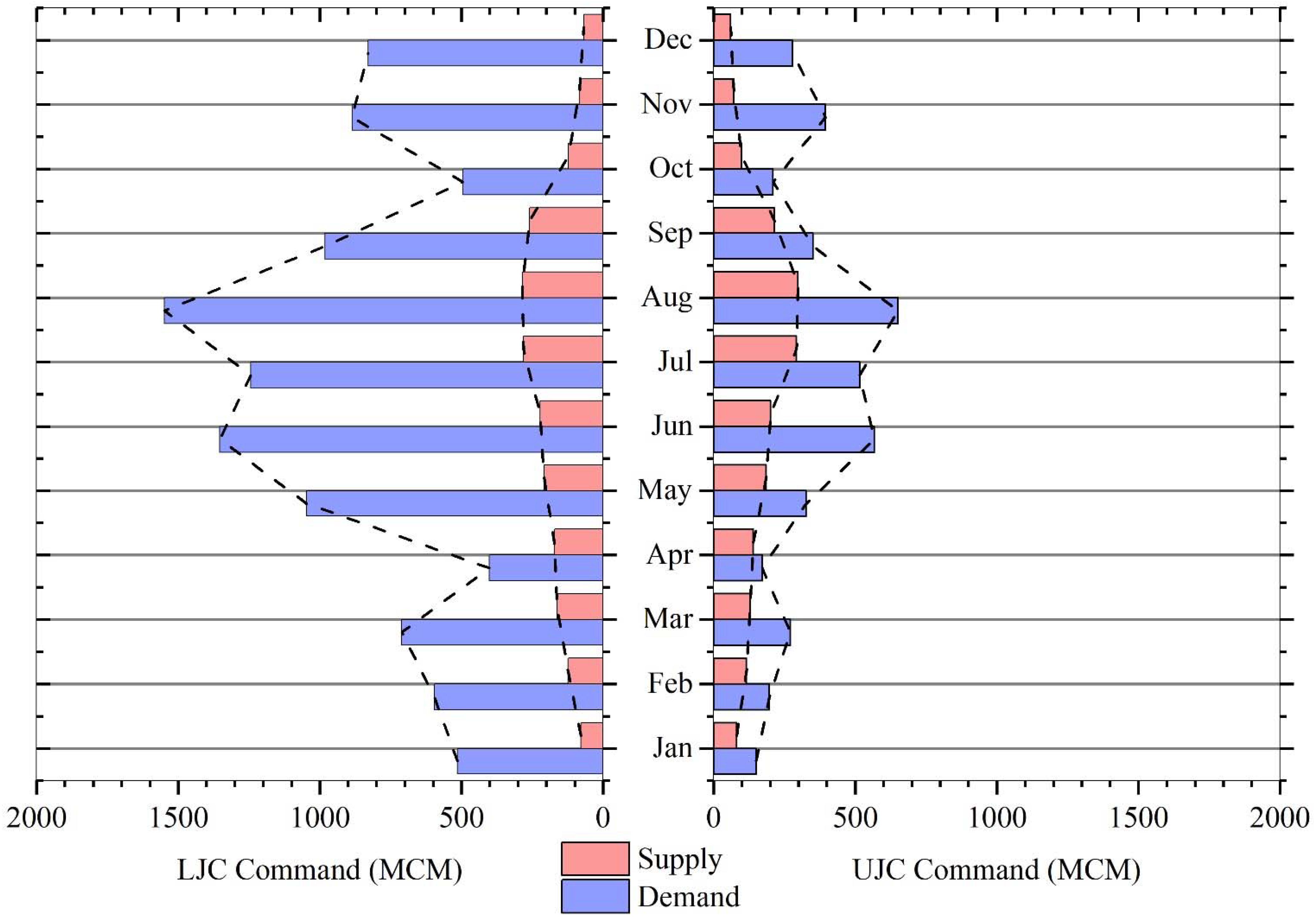
3.3. WEAP Model Simulations to Estimate Canal Water Deficit

The WEAP model simulated results for required irrigation water and water supply for UJC and LJC command areas are presented in Figure 7 for the entire study period (2006–2016). The overall water demand of both the canal command areas of UJC and LJC was 4086 million cubic meters (MCM) and 10,607 million cubic meters (MCM), respectively. LJC has more culturable command areas as compared to UJC and thus has more water demand. The volume of water supplied to UJC and LJC command areas was 1888.8 MCM and 2066.4 MCM, respectively. It is evident from these graphs that the supplied volume of water is not enough to fulfill water demands for both canal commands. However, the demands for irrigation water are higher in the Kharif (Summer) crops (i.e., rice and sugarcane) as compared to Rabi (Winter) crops (i.e., wheat and fodder); see Figure 7. Figure 7 is presented in both bar graph and line graph. The dashed lines joining the extreme points represent the line graph.
The mean annual unmet demand (i.e., water deficit) for the UJC and LJC command areas were 2197.2 MCM and 8540.6 MCM, respectively. Unmet demand gets a peak value in June–August although supplies are greater in these months. The high evapotranspiration rate with rise in temperature in these months (June–August) creates demands for more water [52]. Moreover, the rice and sugarcane water requirement is significantly high. Therefore, the unmet demand is higher in the months of June, July and August.

3.4. Canal Catchment Reliability

The simulated results of the WEAP model showed that the reliability of canal command is decreasing, for example, 61.15% in the Upper Chenab Canal command and 46.41% in the Lower Jhelum Canal command. The relatively smaller percentage of reliability shows more water shortage in those canal command areas for irrigation water. Water supply reliability is largely affected by water demand, water storage and changes in inflow caused by climate variabilities.

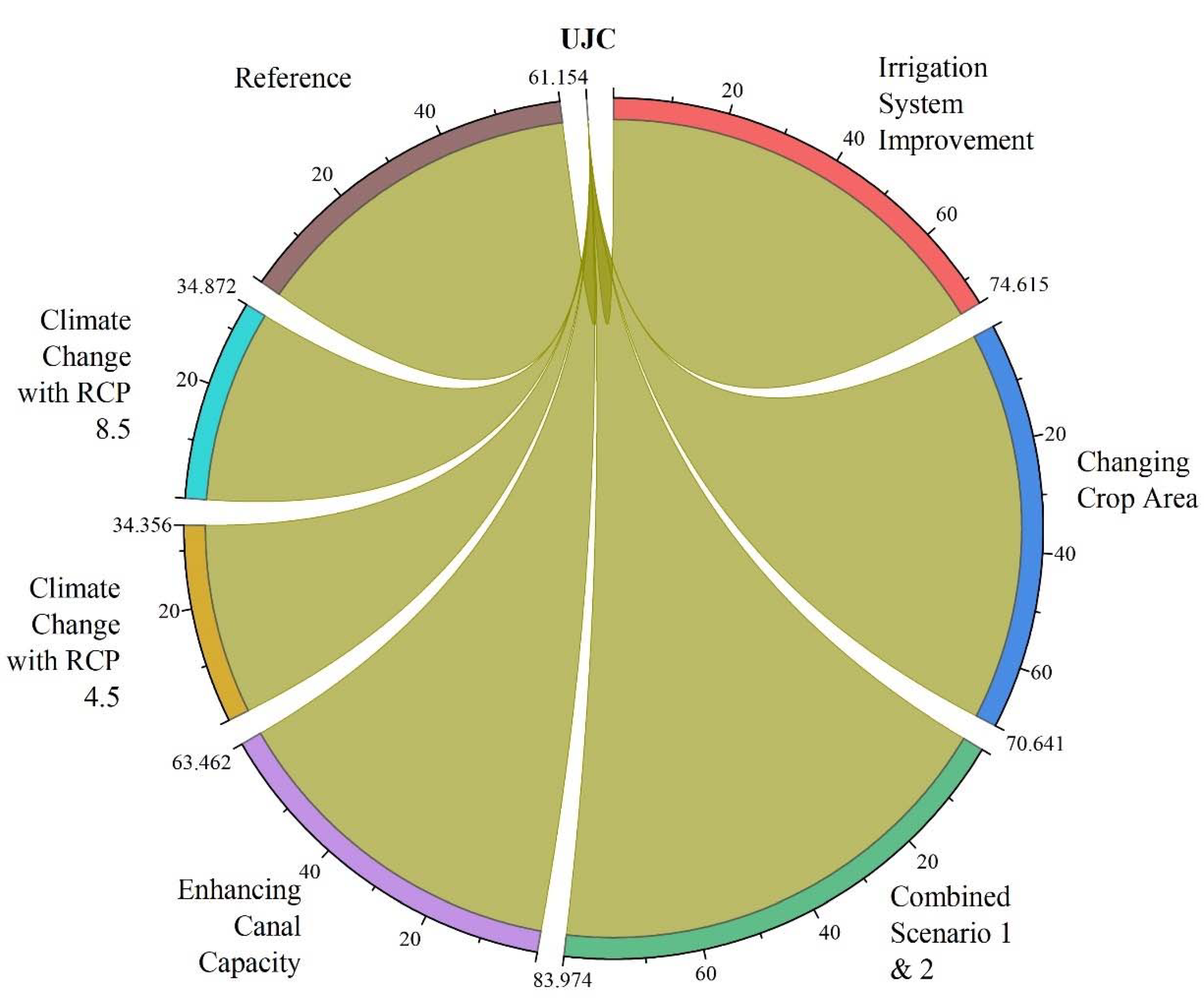
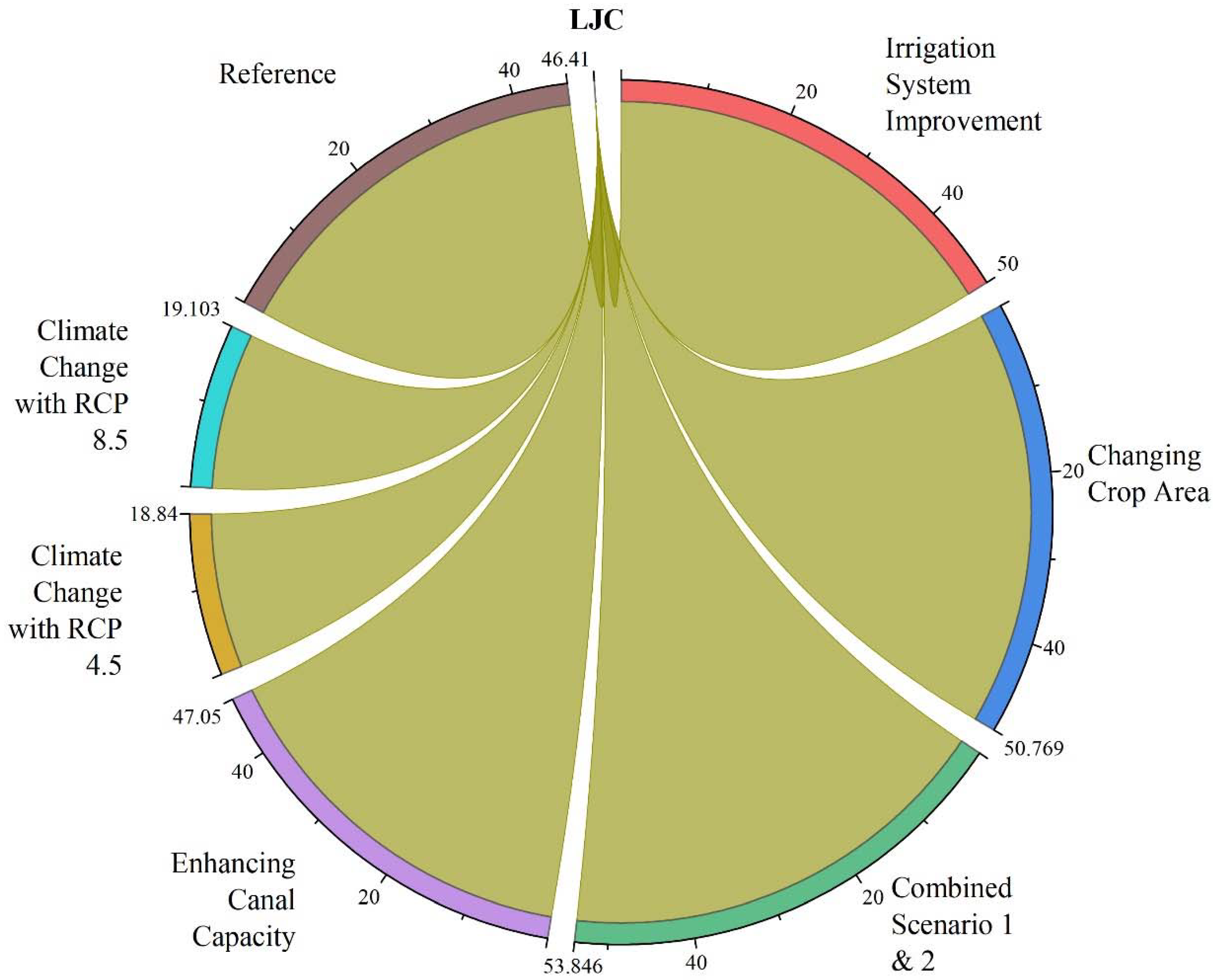
3.5. Future Water Allocation Scenarios

The scenario analysis as described in Table 2 was performed in the WEAP model to optimize the allocated water to the demand sites in order to reduce canal water deficit. The effect of these scenarios was checked on the reliability of the demand sites. Demand site reliability for all the scenarios was compared with the reliability of the reference scenario (Figure 8 and Figure 9). The results showed that with the implementation of the first scenario, the reliability of the UJC command area could be increased from 61% to 75%. On the other hand, LJC command area reliability would improve from 46% to 50%.
The results of the percentage reliability change between the reference and other scenarios are presented in Table 4. Results showed that by simulating the second scenario, reliability of the UJC and LJC commands could be enhanced from 61 to 71% and 46 to 51%, respectively. In Scenario 3, results highlighted that the demand site reliability for the UJC command could be maximized up to 84% from 61% showing a 23% increase in reliability. For the LJC command, the reliability would increase from 46% to 54%, an 8% increase. Thus, this strategy seems very effective, especially in the UJC area. Under scenario 4, results showed that after water allocation, the reliability for the UJC demand site would be increased from 61 to 64%, while for LJC it would increase from 46 to 47%. Results for scenario 5 showed that the demand site reliability for the Upper Chaj Doab would decrease from 61 to 34.36%, while for Lower Chaj Doab it would also decrease from 46 to 18.8%. Results for scenario 6 also showed a decrease in reliability for both catchment areas, in UJC from 61 to 34.87% and in LJC 46 to 19.10%.

4. Discussion

The present study simulated the water demand, several irrigation water allocations practices and future climatic scenarios that were taken into consideration for development of sustainable management of canal water in Chaj Doab, within the Indus Basin Irrigation System (IBIS). Results showed a large gap between water supply and demand in the study area. The water supply in canals is greater in Kharif months (April–October) as compared to the Rabi months (October–March) because of the monsoon season, which results in more rainfall. However, the monsoon season (July–September) and western disturbances contribute a major part of the annual rainfall [53,54]. There are two pairs of months in a year that are recognized as dry periods (April–June and October–November), but mainly two months, October and November [53,54,55]. On the other hand, temperature records are very high in summer months, particularly in June and July [40,56,57]. In Kharif season, the evapotranspiration is greater due to high temperatures, which results in more water demand in these months and hence, water requirement is not satisfied [57,58]. The irrigation water requirement shows a rising trend due to maximum ET in Kharif months from May–August and a low trend in Rabi months during December–January. This large gap is due to less water availability for the crops as compared to their actual water requirement [57,58,59]. The calculation of agricultural water demand highly depends upon the determination of evapotranspiration (ET) [19]. As ET has a direct relationship with crop water demand, the water demand gets a peak value in June, July, August and up to the middle of September because of high temperature, which results in more evapotranspiration.
The unmet demand is greater in November–January because this month’s water supply decreases while cropping intensity increases. Unmet demand decreases in April because Rabi crops are harvested in this month mostly [57,58]. It is of paramount importance to strategically manage the current water resources in order to understand and forecast the hydrological response of this complicated system [39,60]. Scenarios were developed on the basis of water management strategies as well as future climatic variations to optimize the water allocation. Demand site management strategies include water use efficiency improvement, irrigation technology adaptation and a shift towards low water-intensive crops [57,58,59]. Supply management strategies include water supply enhancement by developing storage, inter-region transfer and modifying current operational rules to fulfill water demand [40,58]. Increments in water-use efficiency involve a shift towards a more effective system, for example, sprinkler and drip irrigation instead of less-effective flood and furrow irrigation [52,61]. Shifting towards irrigation technologies was incorporated [62], and that was found to be efficient in increasing irrigation efficiency. A scenario of management through irrigation technology was conceptualized [63], which resulted in fulfilling water demand of crops with less water application. Water conservation techniques such drip and sprinkler irrigation were employed in the WEAP model and their impact on demand site reliability were predicted [64]. The inefficient canal irrigation system of Pakistan results in a large loss of water quantity before it reaches the field crops [39,65,66]. In unlined canals, seepage rates are usually four times greater than lined canals’ seepage rates. Although there very little seepage losses from lined canals, however, about 60 to 80 % of water losses can be saved as compared to unlined canals.
The canal-lining scenario for improvement of conveyance efficiency was analyzed by [52,64]. The scenario analysis indicates that the adaptation of high-water requiring crops, i.e., sugarcane must be replaced with crops that consume less water for demand reduction and that will in turn save water [14,67,68]. A combination of alteration in cropping patterns and irrigation-system improvement is necessary and more effective in reducing irrigation water demand [38,69]. Similar research shows that an increase in irrigation efficiency with a change in cropping patterns is essential for attaining agricultural as well as environmental sustainability, and this strategy also increases reliability [52]. Lining of canals and application of a sprinkler irrigation system maximize system reliability up to 17% and 25%, respectively [64]. Water supplies can be enhanced by increasing diversion from the river into main canals, and more water can be allocated to reduce the unmet demand of water. Maintenance of canals can also increase water supplies.
Future climate change is expected to exaggerate the water shortage. For climate change scenarios, the water shortage difference primarily arises when water use rate is highest. Climate change largely effects water use, but it has comparatively small effects on irrigation water supply as well as its availability [69]. Multiple studies have predicted the impact of climate change on irrigation water demand or possible climate change adaptation pathways [63]. Variations in patterns of snow, precipitation and glacier melting may change the flow timings [1]. Variation in flows and changes in the climate have been going to affect irrigated-agriculture productivity with a significant change in net benefits. However, crop yields are expected to decrease because of climate change [70,71]. Under climate change scenarios, it has been clearly shown by the results that unmet demand will rise in the future as compared to the reference scenario [72]. Results also displayed that unmet water demand is higher under the climate change scenario with RCP 4.5 as compared to the climate change scenario with RCP 8.5 [73]. Demand site water management approaches, i.e., variable cropping structure and improved irrigation systems, will be effective in reducing adverse climate change impacts [69].

5. Proposed Strategies and Conclusions

Based on the findings of the current study and scenario analyses, different strategies are proposed for efficient and effective utilization of the present water resources. Scenario 3, which includes the combined application of improving irrigation systems and reducing and replacing high-water requiring crops with lower-water consuming crops, should be practically implemented. Operate canals at full supply levels, and proper maintenance should be enforced. Rainwater should be harvested, particularly in the monsoon season, by building small storage reservoirs or ponds for dry-period use. Based on future climate change, respective alternate water regulation policies should be revised and replanned based on the crop types, the area covered, and on-field water requirements for efficient water allocation. The main findings of this study are listed below:
  • The annual water demand for the UJC and LJC canal catchment was found to be 4086, and 10,607 million cubic meters (MCM), and the yearly water shortage was found to be 2197.2 and 8540.6 MCM with catchment reliability of 61 and 46%, respectively. Currently, available surface water is not sufficient to meet the demand for agricultural water;
  • The LJC command area is more sensitive to water scarcity, as this area is more than twice the UJC command area with less LJC design discharge as compared to UJC;
  • It is concluded that by adopting scenario 3 (irrigation efficiency improvement through implementation of high-efficiency irrigation systems, canal lining, reduction and replacement of high delta crops with low delta crops), the system reliability can be maximized up to 84% and 54% for the UJC and LJC command areas, respectively;
  • Future climate changes may double the unmet demand, and particularly the LJC command area is seriously going to face water scarcity situations if not properly managed. Additionally, WEAP can be used as a useful hydrological modeling tool for efficient water resources management, and planning for the researchers and respective guidelines for policymakers will have fruitful outcomes.

Author Contributions

Conceptualization, N.A. and A.S.; Data curation, S.A., G.N. and M.A.W.; Formal analysis, S.A., G.N. and A.S.; Funding acquisition, H.L.; Investigation, N.A., A.S. and H.U.F.; Methodology, N.A., S.A., G.N. and M.A.W.; Project administration, H.L.; Resources, H.U.F.; Software, N.A., G.N., M.A.W. and A.S.; Supervision, H.L.; Writing—original draft, M.A.W.; Writing—review & editing, N.A. and A.S. All authors have read and agreed to the published version of the manuscript.

Funding

This study was financially supported by National Key R&D Programs (Grant Number. 2019 Yfc1510504) and National Natural Science Foundation of China (Grant Number. 41830752; 42071033; and 41961134003).

Institutional Review Board Statement

Not Applicable.

Informed Consent Statement

Not Applicable.

Data Availability Statement

All the data sets used in this study have been described in Table 1 and can be acquired from the concerned departments/offices through proper channels. However, the freeware data sets can be downloaded from the websites mentioned in Table 1.

Acknowledgments

The authors are very thankful to the Pakistan Meteorological Department (PMD), the Punjab Irrigation Department (PID), and the Jehanzaib Masoud Cheema (Department of Agricultural Engineering, Arid Agriculture University, Rawalpindi-Pakistan) for sharing the data used in this study. The authors also acknowledge the technical support of WEAP Model developers for their continuous guidance.

Conflicts of Interest

The authors declare no conflict of interest.

References

  1. Archer, D.R.; Forsythe, N.D.; Fowler, H.; Shah, S.M. Sustainability of water resources management in the Indus Basin under changing climatic and socio economic conditions. Hydrol. Earth Syst. Sci. 2010, 14, 1669–1680. [Google Scholar] [CrossRef] [Green Version]
  2. Culas, R.J.; Baig, I.A. Impacts of irrigation water user allocations on water quality and crop productivity: The lcc irrigation system in pakistan. Irrig. Drain. 2020, 69, 38–51. [Google Scholar] [CrossRef]
  3. Moriana, A.; Villalobos, F.; Fereres, E. Stomatal and photosynthetic responses of olive (Olea europaea L.) leaves to water deficits. Plant Cell Environ. 2002, 25, 395–405. [Google Scholar] [CrossRef]
  4. Tognetti, R.; D’Andria, R.; Lavini, A.; Morelli, G. The effect of deficit irrigation on crop yield and vegetative development of Olea europaea L. (cvs. Frantoio and Leccino). Eur. J. Agron. 2006, 25, 356–364. [Google Scholar] [CrossRef]
  5. Smith, M. The application of climatic data for planning and management of sustainable rainfed and irrigated crop production. Agric. For. Meteorol. 2000, 103, 99–108. [Google Scholar] [CrossRef]
  6. National Water Policy. Ministry of Water Resources: Islamabad, Pakistan. 2018. Available online: https://mowr.gov.pk/index.php/national-water-policy-2018/ (accessed on 2 March 2020).
  7. Archer, D. Contrasting hydrological regimes in the upper Indus Basin. J. Hydrol. 2003, 274, 198–210. [Google Scholar] [CrossRef]
  8. Fahim, M.A. Impact of Water Scarcity on Food Security at Macro Level in Pakistan. 2011. Available online: https://mpra.ub.uni-muenchen.de/35758/ (accessed on 5 March 2020).
  9. Latif, M.; Pomee, M.S. Irrigation management turnover: An option for improved utilization of limited water resources in Pakistan. Irrigation and Drainage. J. Int. Comm. Irrig. Drain. 2003, 52, 261–272. [Google Scholar] [CrossRef]
  10. Rinaudo, J.-D.; Strosser, P.; Rieu, T. Linking water market functioning, access to water resources and farm production strategies: Example from Pakistan. Irrig. Drain. Syst. 1997, 11, 261–280. [Google Scholar] [CrossRef]
  11. Hussain, I. Pro-Poor Intervention Strategies in Irrigated Agriculture in Asia: Poverty in Irrigated Agriculture: Issues, Lessons, Options and Guidelines: Bangladesh, China, India, Indonesia, Pakistan and Vietnam. Final Synthesis Report; International Water Management Institute. 2005. Available online: http://www.iwmi.cgiar.org/propoor/files/ADB_Project/Country%20briefs/Synthesis-lessons%20and%20guidelines.pdf (accessed on 5 March 2020).
  12. Bandaragoda, D.J. Limits to donor-driven water sector reforms: Insight and evidence from Pakistan and Sri Lanka. Hydrol. Res. 2006, 8, 51–67. [Google Scholar] [CrossRef]
  13. Tanaka, S.K.; Zhu, T.; Lund, J.R.; Howitt, R.E.; Jenkins, M.W.; Pulido-Velazquez, M.; Tauber, M.; Ritzema, R.S.; Ferreira, I.C. Climate Warming and Water Management Adaptation for California. Clim. Chang. 2006, 76, 361–387. [Google Scholar] [CrossRef]
  14. Khalid, P.D.I.; Khan, M.A. Water Scarcity-A Major Human Security Challenge to Pakistan. South Asian Stud. 2020, 31, 525–539. [Google Scholar]
  15. Sandoval-Solis, S.; McKinney, D.C. Integrated Water Management for Environmental Flows in the Rio Grande. J. Water Resour. Plan. Manag. 2014, 140, 355–364. [Google Scholar] [CrossRef] [Green Version]
  16. Allen, R.G.; Pereira, L.S.; Raes, D.; Smith, M. Crop Evapotranspiration-Guidelines for Computing Crop Water Requirements-FAO Irrigation and Drainage Paper 56; FAO: Rome, Italy, 1998. [Google Scholar]
  17. Luo, X.; Wang, K.; Jiang, H.; Sun, J.; Zhu, Q. Estimation of land surface evapotranspiration over the Heihe River basin based on the revised three-temperature model. Hydrol. Process. 2011, 26, 1263–1269. [Google Scholar] [CrossRef]
  18. Zhuang, Q.; Wu, B. Estimating Evapotranspiration from an Improved Two-Source Energy Balance Model Using ASTER Satellite Imagery. Water 2015, 7, 6673–6688. [Google Scholar] [CrossRef] [Green Version]
  19. Li, J.; Zhu, T.; Mao, X.; Adeloye, A.J. Modeling crop water consumption and water productivity in the middle reaches of Heihe River Basin. Comput. Electron. Agric. 2016, 123, 242–255. [Google Scholar] [CrossRef]
  20. Li, S.; Kang, S.; Zhang, L.; Zhang, J.; Du, T.; Tong, L.; Ding, R. Evaluation of six potential evapotranspiration models for es-timating crop potential and actual evapotranspiration in arid regions. J. Hydrol. 2016, 543, 450–461. [Google Scholar] [CrossRef]
  21. Sechi, G.M.; Sulis, A. Water System Management through a Mixed Optimization-Simulation Approach. J. Water Resour. Plan. Manag. 2009, 135, 160–170. [Google Scholar] [CrossRef]
  22. Perera, B.; James, B.; Kularathna, M. Computer software tool REALM for sustainable water allocation and management. J. Environ. Manag. 2005, 77, 291–300. [Google Scholar] [CrossRef]
  23. Andreu, J.; Capilla, J.; Sanchís, E. AQUATOOL, a generalized decision-support system for water-resources planning and operational management. J. Hydrol. 1996, 177, 269–291. [Google Scholar] [CrossRef]
  24. Fredericks, J.W.; Labadie, J.W.; Altenhofen, J.M. Decision Support System for Conjunctive Stream-Aquifer Management. J. Water Resour. Plan. Manag. 1998, 124, 69–78. [Google Scholar] [CrossRef] [Green Version]
  25. Jha, M.K.; Gupta, A.D. Application of Mike Basin for water management strategies in a watershed. Water Int. 2003, 28, 27–35. [Google Scholar] [CrossRef]
  26. Yates, D.; Sieber, J.; Purkey, D.; Huber-Lee, A. WEAP21—A demand-, priority-, and preference-driven water planning model: Part 1: Model characteristics. Water Int. 2005, 30, 487–500. [Google Scholar] [CrossRef]
  27. Mugatsia, E.A. Simulation and Scenario Analysis of Water Resources Management in Perkerra Catchment Using WEAP Model. Master’s Thesis, Department of Civil and Structural Engineering, School of Engineering, Moi University, Nairobi, Kenya, December 2010. [Google Scholar]
  28. Blanco-Gutiérrez, I.; Varela-Ortega, C.; Flichman, G. Cost-effectiveness of groundwater conservation measures: A multi-level analysis with policy implications. Agric. Water Manag. 2011, 98, 639–652. [Google Scholar] [CrossRef] [Green Version]
  29. Ahmed, N.; Mahmood, S.; Munir, S. Estimation of potential and actual crop evapotranspiration using Weap model. Sci. Int. 2015, 27, 4373–4377. [Google Scholar]
  30. Ahmed, N.; Wang, G.; Booij, M.J.; Oluwafemi, A.; Hashmi, M.Z.-U.; Ali, S.; Munir, S. Climatic Variability and Periodicity for Upstream Sub-Basins of the Yangtze River, China. Water 2020, 12, 842. [Google Scholar] [CrossRef] [Green Version]
  31. Ahmed, N.; Wang, G.-X.; Oluwafemi, A.; Munir, S.; Hu, Z.-Y.; Shakoor, A.; Imran, M.A. Temperature trends and elevation dependent warming during 1965–2014 in headwaters of Yangtze River, Qinghai Tibetan Plateau. J. Mt. Sci. 2020, 17, 556–571. [Google Scholar] [CrossRef]
  32. Marhaento, H.; Booij, M.J.; Ahmed, N. Quantifying relative contribution of land use change and climate change to streamflow alteration in the Bengawan Solo River, Indonesia. Hydrol. Sci. J. 2021, 66, 1059–1068. [Google Scholar] [CrossRef]
  33. Liu, Y.; Chen, Q.; Ge, Q.; Dai, J.; Qin, Y.; Dai, L.; Zou, X.; Chen, J. Modelling the impacts of climate change and crop man-agement on phenological trends of spring and winter wheat in China. Agric. For. Meteorol. 2018, 248, 518–526. [Google Scholar] [CrossRef]
  34. Moat, J.; Gole, T.W.; Davis, A.P. Least concern to endangered: Applying climate change projections profoundly influences the extinction risk assessment for wild Arabica coffee. Glob. Chang. Biol. 2018, 25, 390–403. [Google Scholar] [CrossRef] [Green Version]
  35. Ashraf, M.Q.; Khan, S.A.; Khan, R.; Iqbal, M.W. Determinants of Adaptation Strategies to Climate Change by Farmers in District Sargodha, Pakistan. Int. J. Econ. Environ. Geol. 2019, 9, 16–20. [Google Scholar]
  36. Mahmood, G.G.; Rashid, H.; Anwar, S.; Nasir, A. Evaluation of Climate Change Impacts on Rainfall Patterns in Pothohar Region of Pakistan. Water Conserv. Manag. 2019, 1–6. [Google Scholar] [CrossRef]
  37. Raza, M.H.; Bakhsh, A.; Kamran, M. Managing Climate Change for Wheat Production: An Evidence from Southern Punjab, Pakistan. J. Econ. Impact 2019, 1, 48–58. [Google Scholar] [CrossRef]
  38. Mehta, V.K.; Haden, V.R.; Joyce, B.A.; Purkey, D.R.; Jackson, L.E. Irrigation demand and supply, given projections of climate and land-use change, in Yolo County, California. Agric. Water Manag. 2013, 117, 70–82. [Google Scholar] [CrossRef]
  39. Cheema, M.; Immerzeel, W.; Bastiaanssen, W. Spatial Quantification of Groundwater Abstraction in the Irrigated Indus Basin. Ground Water 2013, 52, 25–36. [Google Scholar] [CrossRef] [Green Version]
  40. Cheema, M. Understanding Water Resources Conditions in Data Scarce River Basins Using Intelligent Pixel Information, Case: Transboundary Indus Basin. Doctoral Thesis, Delft University of Technology, Delft, The Netherlands, 29 May 2012. [Google Scholar]
  41. Dehghanipour, A.; Zahabiyoun, B.; Schoups, G.; Babazadeh, H. A WEAP-MODFLOW surface water-groundwater model for the irrigated Miyandoab plain, Urmia lake basin, Iran: Multi-objective calibration and quantification of historical drought impacts. Agric. Water Manag. 2019, 223. [Google Scholar] [CrossRef]
  42. Schneider, P.; Sander, B.O.; Wassmann, R.; Asch, F. Potential and versatility of WEAP model (Water Evaluation and Planning System) for hydrological assessments of AWD (Alternate Wetting and Drying) in irrigated rice. Agric. Water Manag. 2019, 224, 105559. [Google Scholar] [CrossRef]
  43. Aein, R.; Alizadeh, H. Integrated hydro-economic modeling for optimal design of development scheme of salinity affected irrigated agriculture in Helleh River Basin. Agric. Water Manag. 2021, 243, 106505. [Google Scholar] [CrossRef]
  44. Agarwal, S.; Patil, J.P.; Goyal, V.; Singh, A. Assessment of water supply–demand using water evaluation and planning (WEAP) model for Ur River watershed, Madhya Pradesh, India. J. Inst. Eng. Ser. A 2019, 100, 21–32. [Google Scholar] [CrossRef]
  45. Husain, S.A.; Rhyme, N.H.M. Decision Support Method for Agricultural Irrigation Scenarios Performance Using WEAP Model. Water Eval. Plan. 2020, 99–106. [Google Scholar] [CrossRef]
  46. Rajendran, M.; Gunawardena, E.; Dayawansa, N. Runoff Prediction in an Ungauged Catchment of Upper Deduru Oya Basin, Sri Lanka: A Comparison of HEC-HMS and WEAP Models. Int. J. Progress. Sci. Technol. 2020, 18, 121–129. [Google Scholar]
  47. Jabloun, M.; Sahli, A. WEAP-MABIA Tutorial: A Collection of Stand-Alone Chapters to Aid in Learning the WEAP-MABIA Module; Federal Institute for Geosciences and Natural Resources: Hannover, Germany, 2012.
  48. Esteve, P.; Varela-Ortega, C.; Blanco-Gutiérrez, I.; Downing, T.E. A hydro-economic model for the assessment of climate change impacts and adaptation in irrigated agriculture. Ecol. Econ. 2015, 120, 49–58. [Google Scholar] [CrossRef] [Green Version]
  49. Purkey, D.R.; Huber-Lee, A.; Yates, D.N.; Hanemann, M.; Herrod-Julius, S. Integrating a Climate Change Assessment Tool into Stakeholder-Driven Water Management Decision-Making Processes in California. Water Resour. Manag. 2006, 21, 315–329. [Google Scholar] [CrossRef]
  50. Santikayasa, I.P.; Babel, M.S.; Shrestha, S.; Jourdain, D.; Clemente, R.S. Evaluation of water use sustainability under future climate and irrigation management scenarios in Citarum River Basin, Indonesia. Int. J. Sustain. Dev. World Ecol. 2013, 21, 181–194. [Google Scholar] [CrossRef]
  51. Moriasi, D.N.; Arnold, J.G.; Van Liew, M.W.; Bingner, R.L.; Harmel, R.D.; Veith, T.L. Model evaluation guidelines for systematic quantification of accuracy in watershed simulations. Trans. ASABE 2007, 50, 885–900. [Google Scholar] [CrossRef]
  52. Ahmadaali, J.; Barani, G.-A.; Qaderi, K.; Hessari, B. Analysis of the Effects of Water Management Strategies and Climate Change on the Environmental and Agricultural Sustainability of Urmia Lake Basin, Iran. Water 2018, 10, 160. [Google Scholar] [CrossRef] [Green Version]
  53. Rashid, A. Impact of El-Nino on summer monsoon rainfall of Pakistan. Pak. J. Meteorol. 2004, 1, 35–43. [Google Scholar]
  54. Akhtar, M.; Ahmad, N.; Booij, M.J. Use of regional climate model simulations as input for hydrological models for the Hin-dukush-Karakorum-Himalaya region. Hydrol. Earth Syst. Sci. 2009, 13, 1075–1089. [Google Scholar] [CrossRef] [Green Version]
  55. Naheed, G.; Rasul, G. Investigation of rainfall variability for Pakistan. Pak. J. Meteorol. 2011, 7, 25–32. [Google Scholar]
  56. Aleem-ul-Hassan, M.; Haider, S.; Ullah, K. Diagnostic study of heavy downpour in the central part of Pakistan. Pak. J. Meteorol. 2010, 7, 53–61. [Google Scholar]
  57. Akhtar, I.U.H.; Athar, H. Climate-related inter-annual variability and long-term influence on wheat yield across canal-irrigated areas of Punjab, Pakistan. Theor. Appl. Clim. 2021, 143, 1195–1211. [Google Scholar] [CrossRef]
  58. Akhtar, I.U.H.; Athar, H. Water supply and effective rainfall impacts on major crops across irrigated areas of Punjab, Pakistan. Theor. Appl. Clim. 2020, 142, 1097–1116. [Google Scholar] [CrossRef]
  59. Sajjad, H.; Ghaffar, A. Observed, simulated and projected extreme climate indices over Pakistan in changing climate. Theor. Appl. Clim. 2018, 137, 255–281. [Google Scholar] [CrossRef]
  60. Awan, U.K.; Anwar, A.; Ahmad, W.; Hafeez, M. A methodology to estimate equity of canal water and groundwater use at different spatial and temporal scales: A geo-informatics approach. Environ. Earth Sci. 2016, 75, 1–13. [Google Scholar] [CrossRef]
  61. Parry, J.-E. The Vulnerability of Pakistan’s Water Sector to the Impacts of Climate Change: Identification of Gaps and Recommendations for Action; International Institute for Sustainable Development. 2016. Available online: https://www.iisd.org/publications/vulnerability-pakistans-water-sector-impacts-climate-change-identification-gaps-and (accessed on 23 April 2020).
  62. Fischer, G.; Tubiello, F.N.; van Velthuizen, H.; Wiberg, D. Climate change impacts on irrigation water requirements: Effects of mitigation, 1990–2080. Technol. Forecast. Soc. Chang. 2007, 74, 1083–1107. [Google Scholar] [CrossRef] [Green Version]
  63. Joyce, B.A.; Mehta, V.K.; Purkey, D.R.; Dale, L.L.; Hanemann, M. Modifying agricultural water management to adapt to cli-mate change in California’s central valley. Clim. Chang. 2011, 109, 299–316. [Google Scholar] [CrossRef]
  64. Hassan, D.; Bano, R.; Burian, S.; Ansari, K. Modeling water demand and supply for future water resources management. Int. J. Sci. Eng. Res. 2017, 8, 1745–1750. [Google Scholar]
  65. Masih, I.; Giordano, M. Constraints and opportunities for water savings and increasing productivity through Resource Con-servation Technologies in Pakistan. Agric. Ecosyst. Environ. 2014, 187, 106–115. [Google Scholar]
  66. Karimi, P.; Bastiaanssen, W.G.M.; Molden, D.; Cheema, M.J.M. Basin-wide water accounting based on remote sensing data: An application for the Indus Basin. Hydrol. Earth Syst. Sci. 2013, 17, 2473–2486. [Google Scholar] [CrossRef] [Green Version]
  67. Qureshi, A.S.; Gill, M.A.; Sarwar, A. Sustainable groundwater management in Pakistan: Challenges and opportunities. Irrig. Tion Drain. J. Int. Comm. Irrig. Drain. 2010, 59, 107–116. [Google Scholar] [CrossRef]
  68. Alfarra, A.; Benedict, E.K.; Hötzl, H.; Sader, N.; Sonneveld, B. Modeling Water Supply and Demand for Effective Water Management Allocation in the Jordan Valley. J. Agric. Sci. Appl. 2012, 1, 1–7. [Google Scholar] [CrossRef] [Green Version]
  69. Hao, L.; Sun, G.; Liu, Y.; Qian, H. Integrated Modeling of Water Supply and Demand under Management Options and Climate Change Scenarios in Chifeng City, China. JAWRA J. Am. Water Resour. Assoc. 2015, 51, 655–671. [Google Scholar] [CrossRef]
  70. Zhu, T.; Ringler, C.; Iqbal, M.M.; Sulser, T.B.; Goheer, M.A. Climate change impacts and adaptation options for water and food in Pakistan: Scenario analysis using an integrated global water and food projections model. Water Int. 2013, 38, 651–669. [Google Scholar] [CrossRef]
  71. Shakoor, U.; Saboor, A.; Baig, I.; Afzal, A.; Rahman, A. Climate variability impacts on rice crop production in Pakistan. Pak. J. Agric. Res. 2015, 28, 19–27. [Google Scholar]
  72. Berredjem, A.-F.; Hani, A. Modelling current and future supply and water demand in the northern region of the Seybouse Valley. J. Water Land Dev. 2017, 33, 31–38. [Google Scholar] [CrossRef] [Green Version]
  73. Arsiso, B.K.; Tsidu, G.M.; Stoffberg, G.H.; Tadesse, T. Climate change and population growth impacts on surface water supply and demand of Addis Ababa, Ethiopia. Clim. Risk Manag. 2017, 18, 21–33. [Google Scholar] [CrossRef]
Figure 1. Map of the study area along with off-taking branch canals for irrigation.
Sustainability 13 08695 g001
Figure 2. Land use/cover types for Rabi (2013–14) and Kharif (2014) in the Chaj Doab.
Sustainability 13 08695 g002
Figure 3. Schematic view of the Chaj Doab in WEAP Model.
Sustainability 13 08695 g003
Figure 4. Conceptual modeling flowchart adopted in this study.
Sustainability 13 08695 g004
Figure 5. Monthly observed and simulated streamflow during calibration (2006–2010) and validation (2011–2016) period for UJC and LJC commands.
Sustainability 13 08695 g005
Figure 6. Scatter plot for calibration and validation on 1:1 scale for UJC and LJC.
Sustainability 13 08695 g006
Figure 7. Irrigation water supply and demand for LJC and UJC command areas.
Sustainability 13 08695 g007
Figure 8. Reliability (%) comparison of reference scenario with all six scenarios for UJC command area.
Sustainability 13 08695 g008
Figure 9. Reliability (%) comparison of reference scenario with all six scenarios for LJC command area.
Sustainability 13 08695 g009
Table 1. Input data for the development of the Water Evaluation and Planning (WEAP) model.
Serial No.Data Type & Description Frequency/TypeDurationData Source
1Discharge data of Mangla Dam, Jhelum River, LJC and UJCDaily Basis2006–2016Punjab Irrigation Department (PID), Lahore
2Climatic Data
(Max. temperature
and Min. temperature, Rainfall, Wind Speed Humidity, Sunshine Hours and Latitude, Longitude)
Monthly Basis2006–2016Pakistan Meteorological Department (PMD)
3Soil Data
(Soil type of Upper Jhelum Canal (UJC) & Lower Jhelum Canal (LJC) command area)
Raster fileSoil map for both command areas in Chaj DoabHarmonized World Soil Database V 1.2 (HWSD). Food and Agriculture Organization (FAO) of the United Nations.
http://webarchive.iiasa.ac.at/Research/LUC/External-World-soil-database (accessed on 21 October 2019)
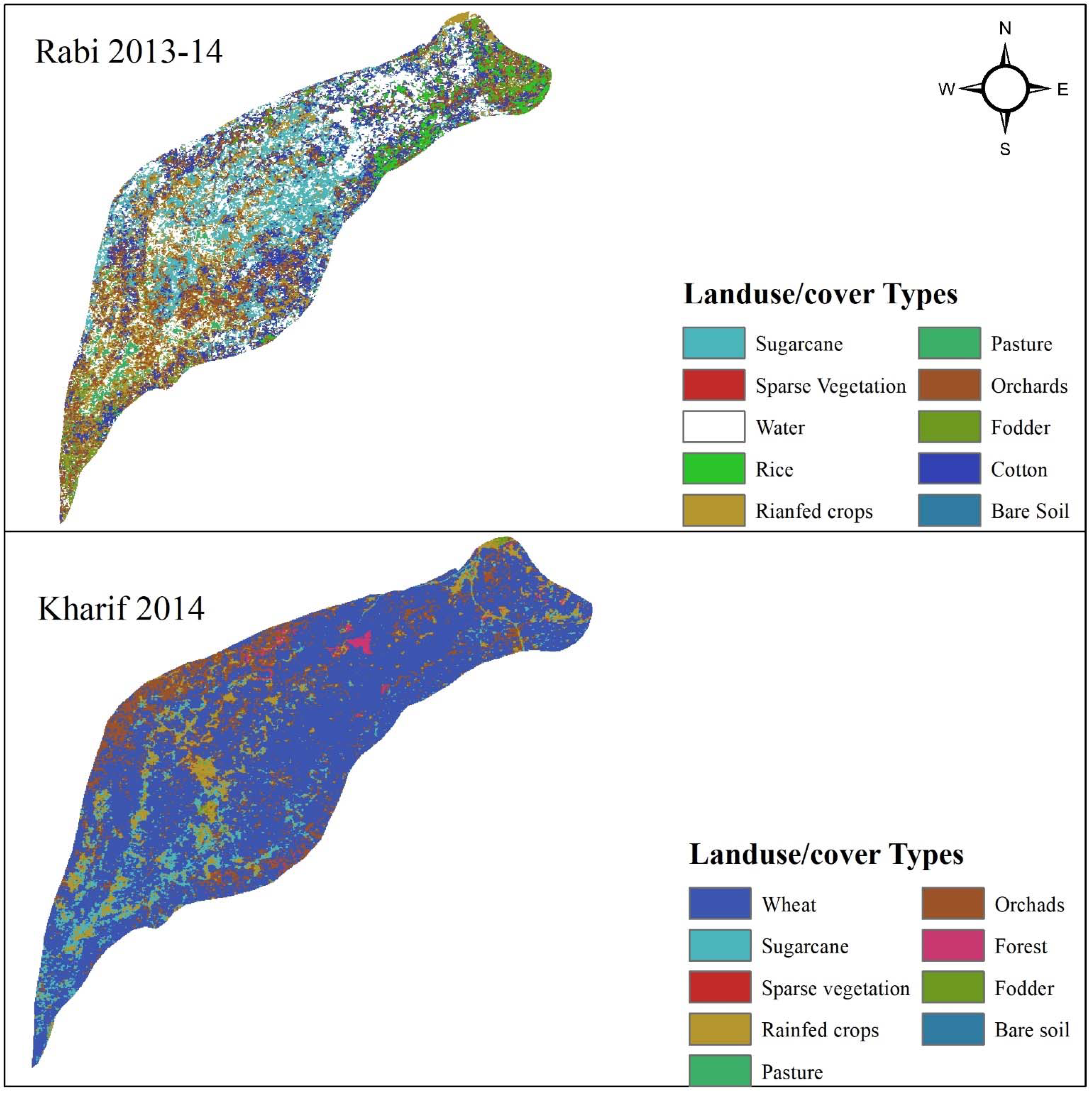
4Land use & land Cover DataRaster file for Rabi & Kharif season2013–2014Land use/cover data for Rabi 2013-14 and Kharif 2013 was derived from Landsat 8 which was also validated by Cheema [40], see Figure 2
5Agricultural data
(Crop Type, Crop Planting Month & date, harvesting date, Crop Co-efficient, Crop Height, Root Depth, Growth Stages Length, Crop Season Length, Vegetative Fraction Covered
Yearly Basis2006–2016Yearly online published Reports (concerned Agri. Departments) & FAO. 56
6Shapefiles
(River Jhelum, UJC & LJC and its Command areas)
--Punjab Irrigation
Department, (PID), Lahore.
Table 2. Description of all scenarios developed in WEAP model.
ScenariosStrategies Implementation
Scenario-1: (Irrigation System Improvement)Increase in irrigation efficiency (85%) using drip and sprinkler technologies, and Seepage losses reduction through canal lining (50%)
Scenario-2: (Changing Crop Area)Reduction in area of High delta crop and replacement with low water delta crops (50%)
Scenario-3: (Combination of Scenario 1 and 2)Irrigation Efficiency (85%), Seepage losses reduction (50%), area reduction of high delta crops and replacement (50%)
Scenario-4: Canal Capacity EnhancementIncreasing canal capacity through canal maintenance i.e., silt removal and increase in canal diversions (20%)
Scenario-5: Climate Change with RCP 4.5Future climate change impact (Temperature & Rainfall data) with RCP 4.5 up to 2070
Scenario-6: Climate Change with RCP 8.5Future climate change impact (Temperature & Rainfall data) with RCP 8.5 up to 2070
Table 3. Model evaluation coefficients values for calibration and validation.
Evaluation CriterionCalibrationValidation
Upper Jhelum Canal (UJC)Lower Jhelum Canal (LJC)Upper Jhelum Canal (UJC)Lower Jhelum Canal (LJC)
NSE0.910.830.80.83
PBIAS−2.92−7.01−1.48−2.97
R20.930.870.830.85
Table 4. Percentage reliability comparison between reference scenario and other scenarios.
Scenario TypesChange in Reliability (%)
Upper Jhelum Canal
(UJC)
Lower Jhelum Canal (LJC)
Reference ScenarioNo ChangeNo Change
Scenario-1: (Irrigation System Improvement)+13.46+3.59
Scenario-2: (Changing Crop Area)+9.49+4.36
Scenario-3: (Combination of Scenario 1 and 2)+22.82+7.44
Scenario-4: Canal Capacity Enhancement+2.31+0.64
Scenario-5: Climate Change with RCP 4.5−26.80−27.56
Scenario-6: Climate Change with RCP 8.5−26.28−27.31
(+) sign indicates the percentage increase in demand site reliability and (−) sign shows percentage decrease in demand site reliability as compared to the reference scenario.
Publisher’s Note: MDPI stays neutral with regard to jurisdictional claims in published maps and institutional affiliations.

