
Impact of Social and Economic Development on Sediment Load of the Yellow River


Abstract
:1. Introduction
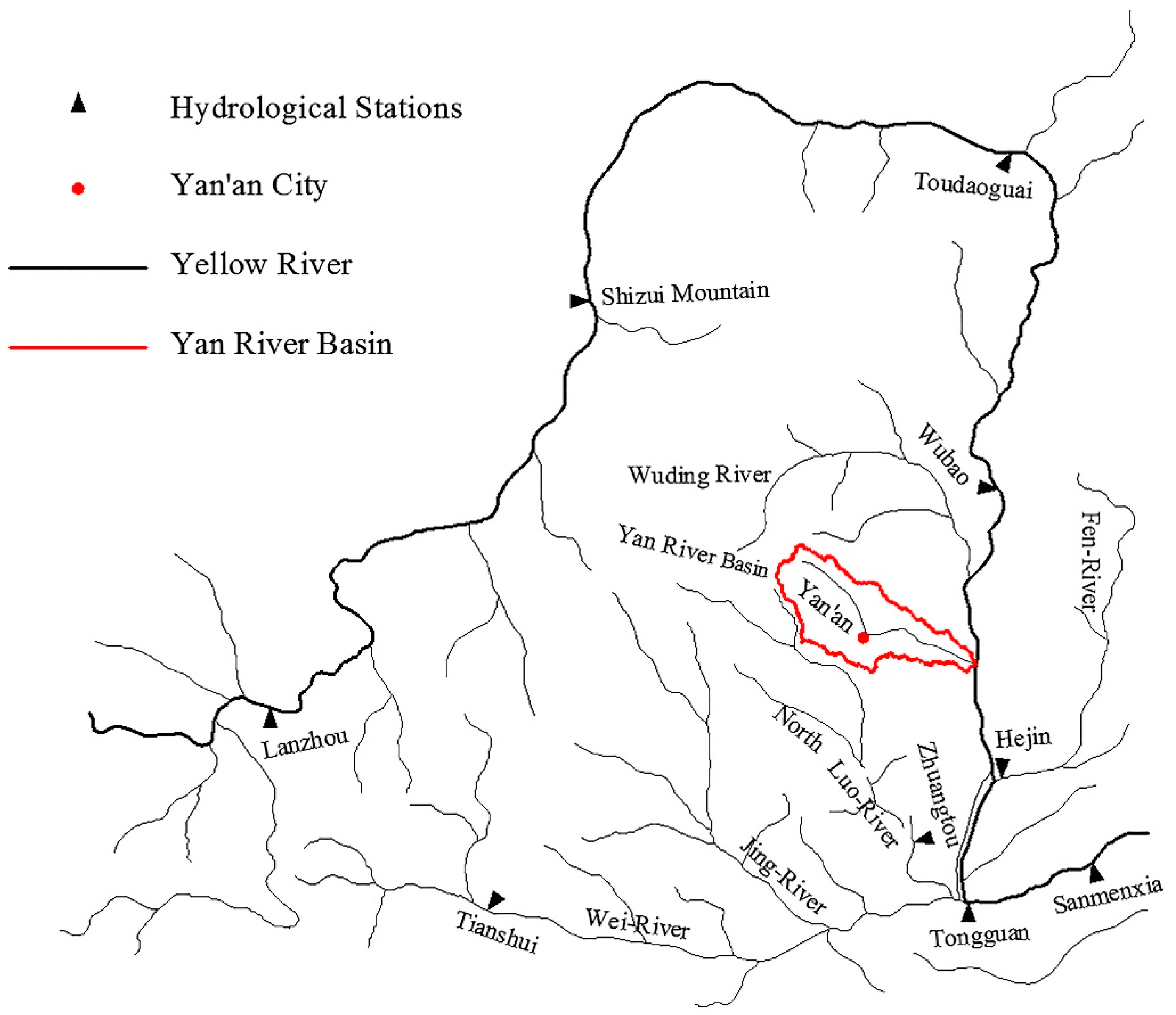
2. Regional Setting
3. Data and Methods
3.1. Data
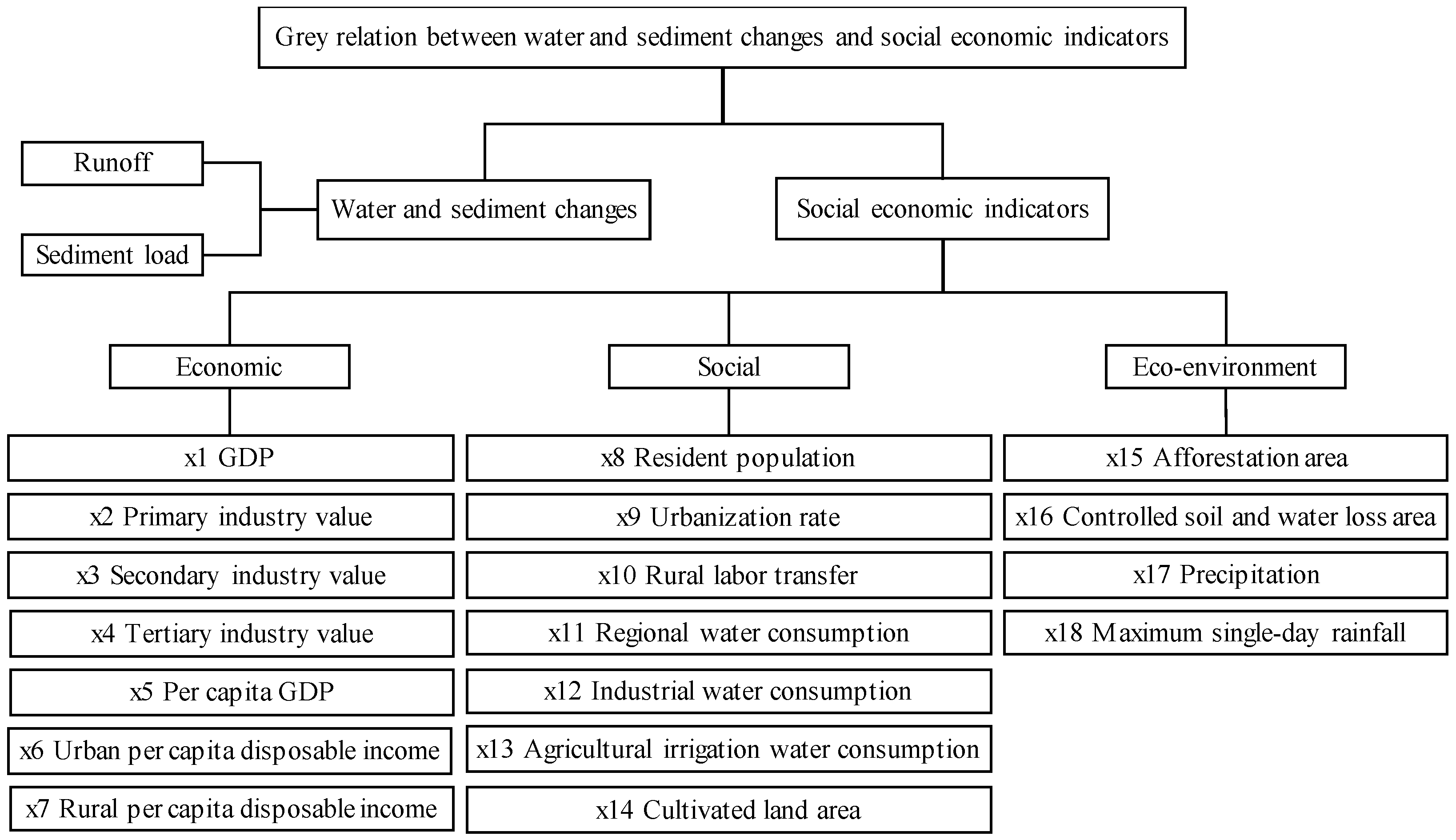
3.2. Methods
4. Results
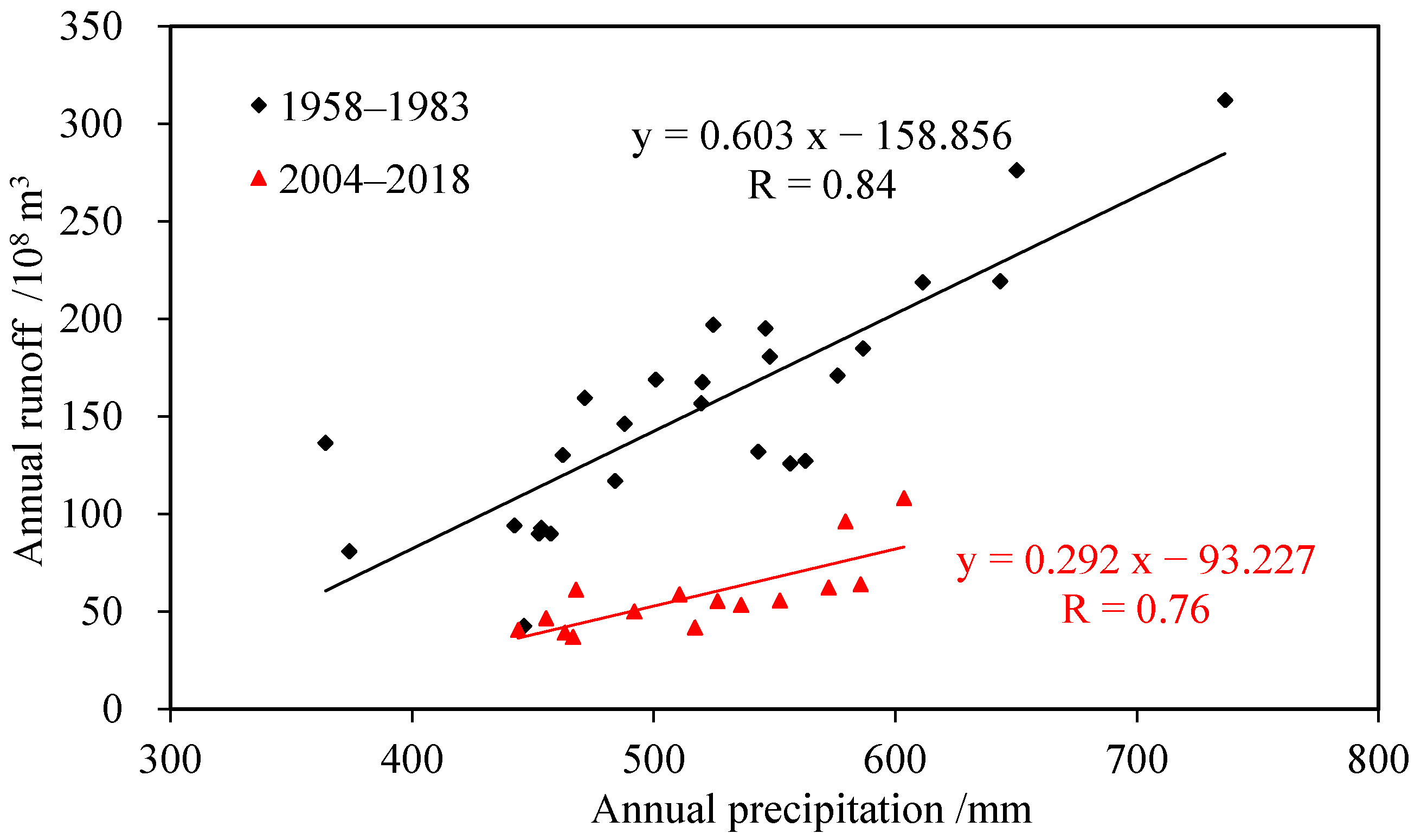
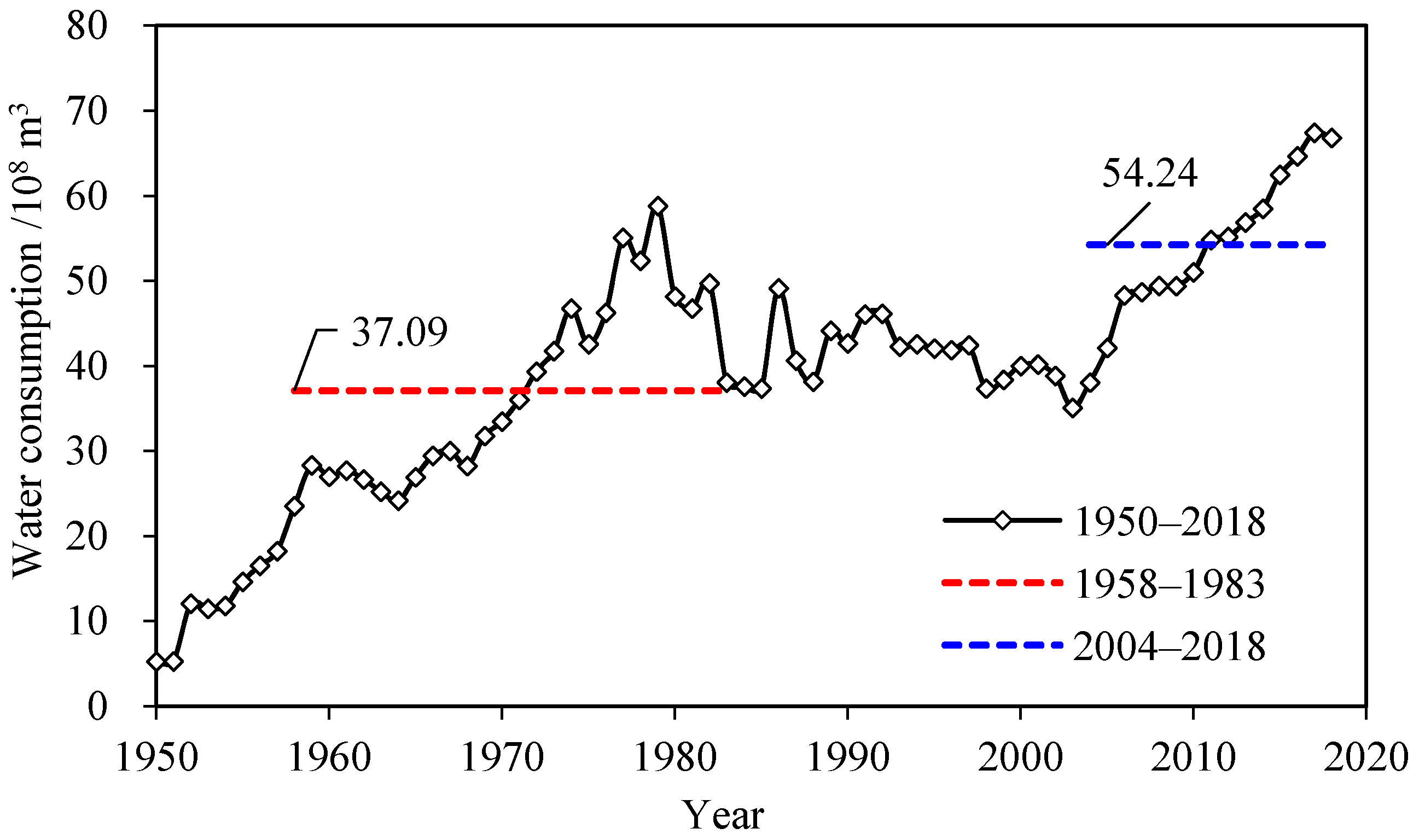
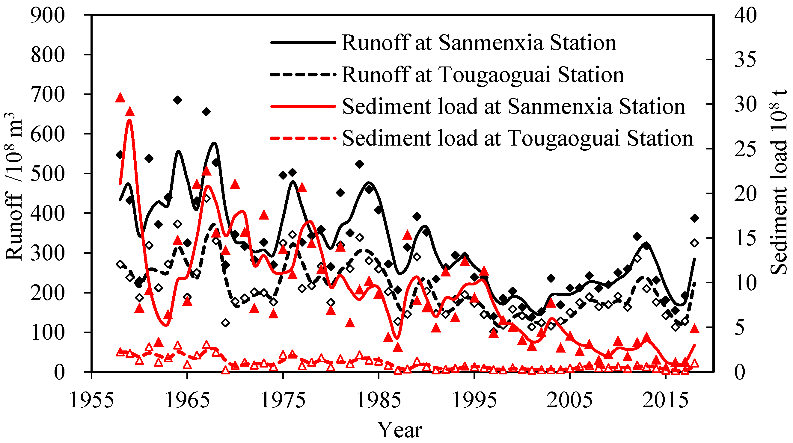
4.1. Changes in Runoff of the Yellow River and Its Causes
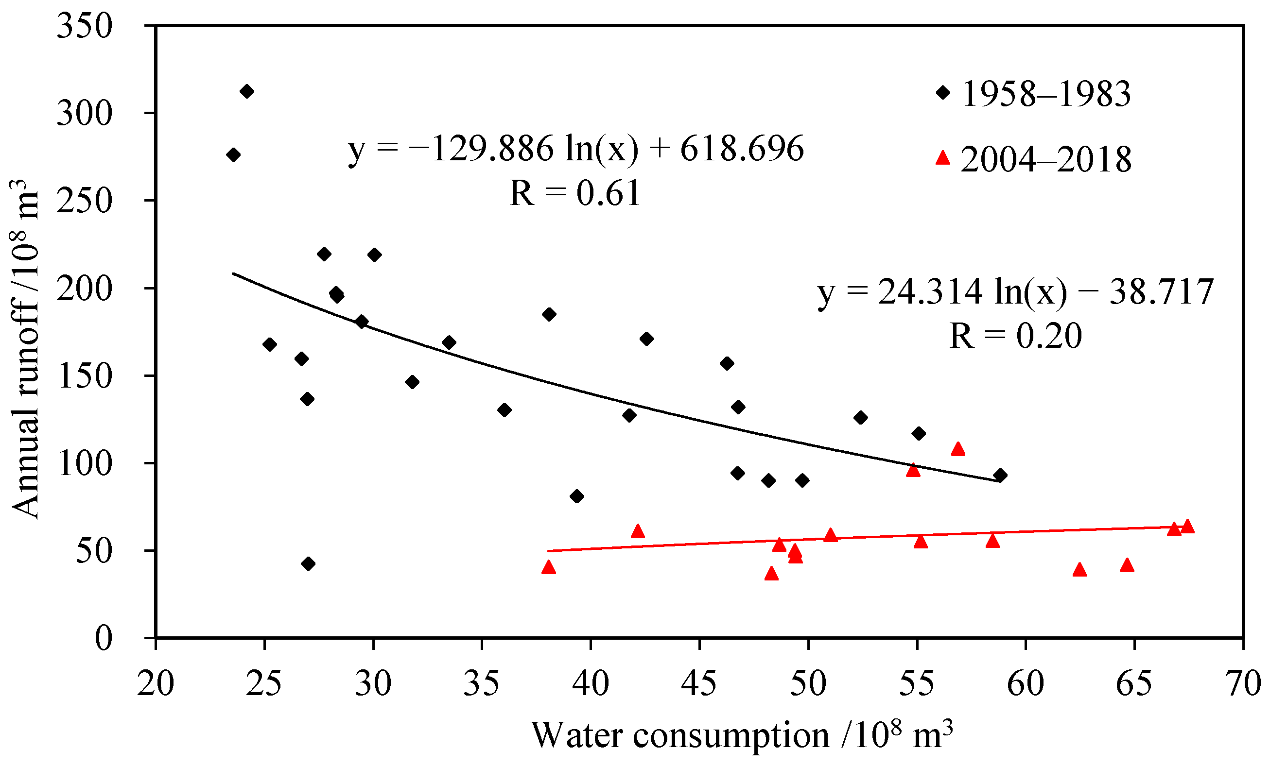
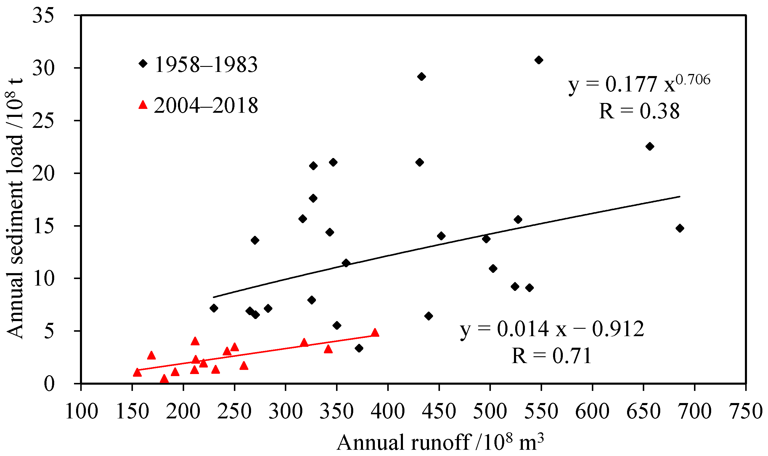
4.2. Changes in Sediment Load of the Yellow River and Its Causes
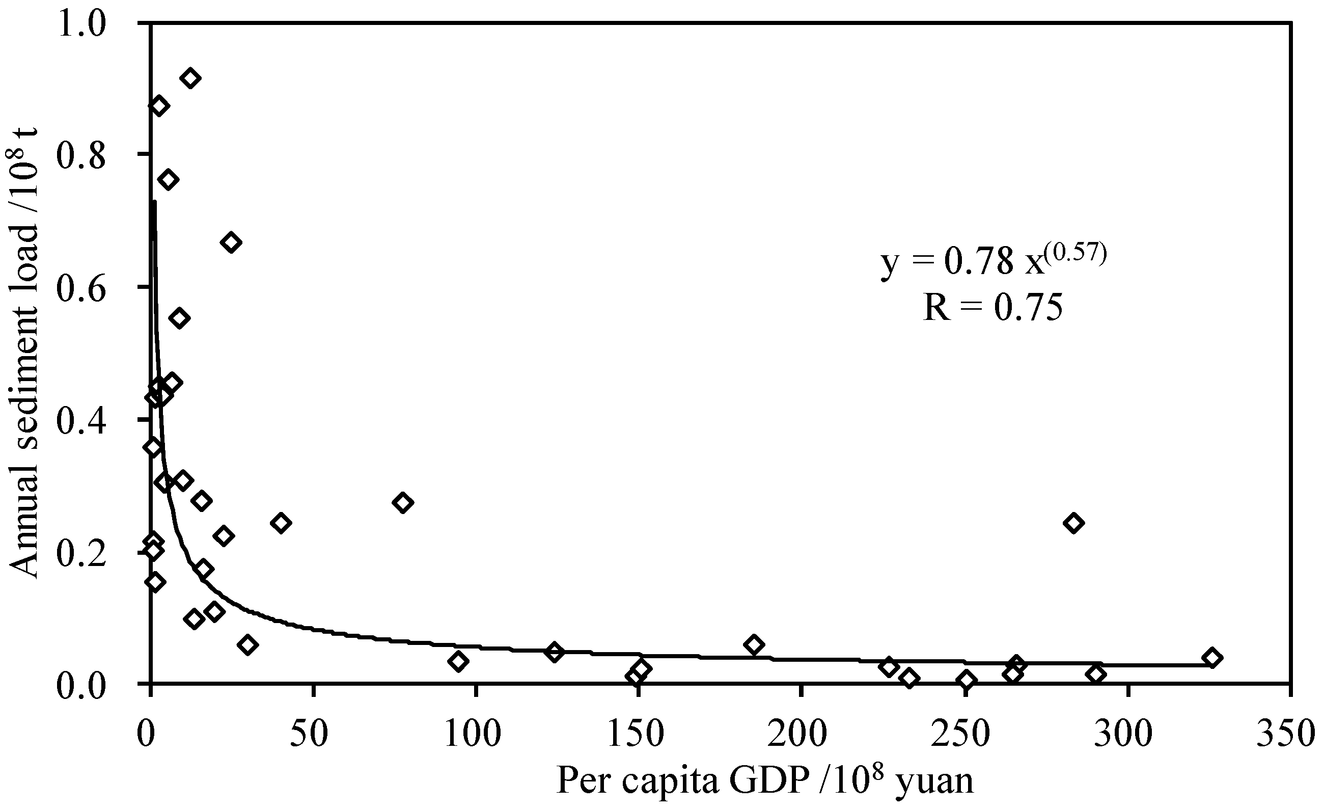
4.3. Relationship Between per Capita GDP and Sediment Load in the Yan River Basin
4.4. Analysis of Causes of Changes in Water and Sediment Regimes in the Yan River Basin
5. Discussion
5.1. Social and Economic Factors Affecting Sediment Yield of the Yellow River
5.2. The Impact of Social and Economic Development on Sediment Load in a Typical Tributary of the Yellow River
6. Conclusions
- (1).
- The average annual runoff and sediment load at Sanmenxia station on the Yellow River decreased by 41.5% and 82.0%, respectively in 2004–2018, compared with those in 1958–1983. The decrease in runoff was mainly caused by an increase in water consumption. Approximately 39.3% of the sediment reduction was due to the decrease in runoff, and the remaining 66.4% was attributed to other factors.
- (2).
- During the periods 1958–1983 and 2004–2018, the average annual runoff and sediment load in the Yan River decreased by 35.6% and 86.3%, respectively. An inverse relation between the per capita GDP and the sediment load can be observed over the past 25 years in the Yan River basin, and the sediment reduction was notable at an early stage, steadily declining to a relatively low level by the end of the period.
- (3).
- The sediment load in the Yan River was highly related to the transfer of rural laborers, the afforestation area, and the tertiary industry value during 2000–2018, indicating that human activities can both increase sediment and reduce sediment. Thus, in recent decades, the development of the social economy in the river basin decreased the sediment yield to some extent.
Author Contributions
Funding
Institutional Review Board Statement
Informed Consent Statement
Data Availability Statement
Acknowledgments
Conflicts of Interest
References
- Syvitski, J.P.; Kettner, A.J.; Overeem, I.; Hutton, E.W.; Hannon, M.T.; Brakenridge, G.R.; Day, J.; Vrocmarty, C.; Saito, Y.; Nicholls, R.J. Sinking deltas due to human activities. Nat. Geosci. 2009, 2, 681–686. [Google Scholar] [CrossRef]
- Zhong, X.; Jiang, X.H.; Li, L.L.; Xu, J.; Xu, H.Y. The impact of socio-economic factors on sediment load: A case study of the Yanhe River Watershed. Sustainability 2020, 12, 2457. [Google Scholar] [CrossRef] [Green Version]
- Wen, T.F.; Xiong, L.H.; Jiang, C.; Hu, J.M.; Liu, Z.J. Effects of climate variability and human activities on suspended sediment load in the Ganjiang River Basin, China. J. Hydrol. Eng. 2019, 24, 05019029. [Google Scholar] [CrossRef]
- Wei, X.; Cai, S.Q.; Ni, P.T.; Zhan, W.K. Impacts of climate change and human activities on the water discharge and sediment load of the Pearl River, southern China. Sci. Rep. 2020, 10, 16743. [Google Scholar] [CrossRef] [PubMed]
- Wu, J.W.; Miao, C.Y.; Yang, T.T.; Duan, Q.Y.; Zhang, X.M. Modeling streamflow and sediment responses to climate change and human activities in the Yanhe River, China. Hydrol. Res. 2017, 49, 150–162. [Google Scholar] [CrossRef]
- Guo, L.P.; Mu, X.M.; Hu, J.M.; Gao, P.; Zhang, Y.F.; Liao, K.T.; Bai, H.; Chen, X.L.; Song, Y.J.; Jin, N.; et al. Assessing impacts of climate change and human activities on streamflow and sediment discharge in the Ganjiang River Basin (1964–2013). Water 2019, 11, 1679. [Google Scholar] [CrossRef] [Green Version]
- Moraes, J.M.; Pellegrino, G.Q.; Ballester, M.V.; Martinelli, L.A.; Victoria, R.L.; Krusche, A.V. Trends in hydrological parameters of a southern Brazilian watershed and its relation to human induced changes. Water Resour. Manag. 1998, 12, 295–311. [Google Scholar] [CrossRef]
- Mu, X.M.; Zhang, X.Q.; Shao, H.B.; Gao, P.; Wang, F.; Jiao, J.Y.; Zhu, J.L. Dynamic changes of sediment discharge and the influencing factors in the Yellow River, China, for the recent 90 years. Clean Soil Air Water 2012, 40, 303–309. [Google Scholar] [CrossRef]
- Wang, Y.; Ding, Y.J.; Ye, B.S.; Liu, F.J.; Wang, J.; Wang, J. Contributions of climate and human activities to changes in runoff of the Yellow and Yangtze rivers from 1950 to 2008. Sci. China Earth Sci. 2013, 56, 1398–1412. [Google Scholar] [CrossRef]
- Sun, P.; Wu, Y.; Gao, J.; Yao, Y.; Zhao, F. Shifts of sediment transport regime caused by ecological restoration in the Middle Yellow River Basin. Sci. Total Environ. 2020, 698, 134261. [Google Scholar] [CrossRef]
- Liu, J.J.; Zhou, Z.H.; Yan, Z.Q.; Gong, J.G.; Jia, Y.W.; Xu, C.Y.; Wang, H. A new approach to separating the impacts of climate change and multiple human activities on water cycle processes based on a distributed hydrological model. J. Hydrol. 2019, 578, 124096. [Google Scholar] [CrossRef]
- Shi, P.; Zhang, Y.; Ren, Z.Q.; Yu, Y.; Li, P.; Gong, J.F. Land-use changes and check dams reducing runoff and sediment yield on the Loess Plateau of China. Sci. Total Environ. 2019, 664, 984–994. [Google Scholar] [CrossRef] [PubMed]
- Dai, S.B.; Lu, X.X. Sediment load change in the Yangtze River (Changjiang): A review. Geomorphology 2014, 215, 60–73. [Google Scholar] [CrossRef]
- Li, Z.W.; Xu, X.L.; Yu, B.F.; Xu, C.H.; Liu, M.X. Quantifying the impacts of climate and human activities on water and sediment discharge in a karst region of southwest China. J. Hydrol. 2016, 542, 836–849. [Google Scholar] [CrossRef]
- Jiang, C.; Pan, S.Q.; Chen, S.L. Recent morphological changes of the Yellow River (Huanghe) submerged delta: Causes and environmental implications. Geomorphology 2017, 293, 93–107. [Google Scholar]
- Bi, N.S.; Wang, H.J.; Yang, Z.S. Recent changes in the erosion–accretion patterns of the active Huanghe (Yellow River) delta lobe caused by human activities. Cont. Shelf Res. 2014, 90, 70–78. [Google Scholar] [CrossRef]
- Peng, J.; Chen, S.L.; Dong, P. Temporal variation of sediment load in the Yellow River basin, China, and its impacts on the lower reaches and the river delta. Catena 2010, 83, 135–147. [Google Scholar] [CrossRef]
- Liu, C.; Walling, D.E.; He, Y. Review: The international sediment initiative case studies of sediment problems in river basins and their management. Int. J. Sediment Res. 2018, 33, 216–219. [Google Scholar] [CrossRef]
- Tan, G.M.; Fang, H.W.; Dey, S.; Wu, W.M. Rui-Jin Zhang’s research on sediment transport. J. Hydraul. Eng. 2018, 144, 02518002. [Google Scholar] [CrossRef]
- Deng, L.; Shangguan, Z.P.; Sweeney, S. “Grain for Green” driven land use change and carbon sequestration on the Loess Plateau, China. Sci. Rep. 2014, 4, 7039. [Google Scholar] [CrossRef] [PubMed]
- Yu, Y.; Wang, H.; Shi, X.; Ran, X.; Cui, T. New discharge regime of the Huanghe (Yellow River): Causes and implications. Cont. Shelf Res. 2013, 69, 62–72. [Google Scholar] [CrossRef]
- Wu, L.; Peng, M.; Liu, X. An evaluation of sediment yield evolutions for different sub-catchments and land use types in the Yanhe river watershed, Loess Plateau. Fresen. Environ. Bull. 2017, 25, 7860–7873. [Google Scholar]
- Mozeika, A.; Sheikh, M.; Lopez, F.A.; Antenucci, F.; Coolen, A.C.C. Exact results on high-dimensional linear regression via statistical physics. Phys. Rev. E 2021, 103, 042142. [Google Scholar] [CrossRef] [PubMed]
- Deng, J.L. Control problems of grey systems. Syst. Control Lett. 1982, 1, 288–294. [Google Scholar]
- Winarni, S.; Indratno, S.W. Application of multi response optimization with grey relational analysis and fuzzy logic method. J. Phys. Conf. Ser. 2018, 948, 012075. [Google Scholar] [CrossRef]
- Li, C.D.; Li, Z.B.; Yang, M.Y.; Ma, B.; Wang, B.Q. Grid-Scale Impact of Climate Change and Human Influence on Soil Erosion within East African Highlands (Kagera Basin). Int. J. Environ. Res. Public Health 2021, 18, 2775. [Google Scholar] [CrossRef] [PubMed]
- Gellis, A.; Hereford, R.; Schumm, S.A.; Hayes, B.R. Channel evolution and hydrologic variations in the Colorado River basin: Factors influencing sediment and salt loads. J. Hydrol. 1991, 124, 317–344. [Google Scholar] [CrossRef]
- Zhao, G.J.; Kondolf, G.M.; Mu, X. Sediment yield reduction associated with land use changes and check dams in a catchment of the Loess Plateau, China. Catena 2016, 148, 1–17. [Google Scholar] [CrossRef]
- Huang, L.; Li, X.; Fang, H.; Yin, D.; Si, Y.; Wei, J. Balancing social, economic and ecological benefits of reservoir operation during the flood season: A case study of the Three Gorges Project, China. J. Hydrol. 2019, 572, 422–434. [Google Scholar] [CrossRef]
- Jin, Z.; Cui, B.; Song, Y.; Shi, W.; Wang, K.; Wang, Y. How many check dams do we need to build on the Loess Plateau. Environ. Sci. Technol. 2012, 46, 8527–8528. [Google Scholar] [CrossRef] [PubMed]
- Zhou, H.; Van Rompaey, A.; Wang, J.A. Detecting the impact of the “Grain for Green” program on the mean annual vegetation cover in the Shaanxi province, China using SPOT-VGT NDVI data. Land Use Policy 2009, 26, 954–960. [Google Scholar] [CrossRef]
- Du, J.; Shi, C.X.; Fan, X.L.; Zhou, Y.Y. Impacts of socio-economic factors on sediment yield in the Upper Yangtze River. J. Geogr. Sci. 2011, 21, 359–371. [Google Scholar] [CrossRef]
- Bi, Z.L.; Zhang, Y.; Shi, P.; Zhang, X.; Shan, Z.X.; Ren, L.J. The impact of land use and socio-economic factors on ammonia nitrogen pollution in Weihe River watershed, China. Environ. Sci. Pollut. R. 2021, 28, 17659–17674. [Google Scholar] [CrossRef] [PubMed]
- Whitehead, P.G.; Jin, L.; Macadam, I.; Janes, T.; Sarkar, S.; Rodda, H.J.E.; Sinha, R.; Nicholls, R.J. Modelling impacts of climate change and socio-economic change on the Ganga, Brahmaputra, Meghna, Hooghly and Mahanadi river systems in India and Bangladesh. Sci. Total Environ. 2018, 636, 1362–1372. [Google Scholar] [CrossRef] [PubMed] [Green Version]


| Period | Ganguyi Station in the Yan River | Sanmenxia Station in the Yellow River | Proportion | |||
|---|---|---|---|---|---|---|
| Runoff 108 m3/yr | Sediment Load 108 t/yr | Runoff 108 m3/yr | Sediment Load 108 t/yr | Runoff % | Sediment Load % | |
| 1958–1983 | 2.25 | 0.51 | 408.3 | 13.73 | 0.55 | 3.71 |
| 2004–2018 | 1.45 | 0.07 | 238.7 | 2.48 | 0.61 | 2.82 |
| Economic | x1 | x2 | x3 | x4 | x5 | x6 | x7 |
| Runoff | 0.584 | 0.585 | 0.576 | 0.591 | 0.588 | 0.581 | 0.595 |
| Sediment load | 0.546 | 0.581 | 0.529 | 0.610 | 0.541 | 0.558 | 0.574 |
| Social | x8 | x9 | x10 | x11 | x12 | x13 | x14 |
| Runoff | 0.448 | 0.610 | 0.707 | 0.522 | 0.560 | 0.500 | 0.451 |
| Sediment load | 0.405 | 0.535 | 0.723 | 0.447 | 0.501 | 0.443 | 0.413 |
| Eco-Environment | x15 | x16 | x17 | x18 | |||
| Runoff | 0.739 | 0.728 | 0.650 | 0.704 | |||
| Sediment load | 0.629 | 0.566 | 0.509 | 0.550 |
Publisher’s Note: MDPI stays neutral with regard to jurisdictional claims in published maps and institutional affiliations. |
© 2021 by the authors. Licensee MDPI, Basel, Switzerland. This article is an open access article distributed under the terms and conditions of the Creative Commons Attribution (CC BY) license (https://creativecommons.org/licenses/by/4.0/).
Share and Cite
Tan, G.; Han, S.; Yu, Y.; Hu, R.; Lv, Y.; Shu, C. Impact of Social and Economic Development on Sediment Load of the Yellow River. Sustainability 2021, 13, 7976. https://doi.org/10.3390/su13147976
Tan G, Han S, Yu Y, Hu R, Lv Y, Shu C. Impact of Social and Economic Development on Sediment Load of the Yellow River. Sustainability. 2021; 13(14):7976. https://doi.org/10.3390/su13147976
Chicago/Turabian StyleTan, Guangming, Shasha Han, Yuecong Yu, Rui Hu, Yiwei Lv, and Caiwen Shu. 2021. "Impact of Social and Economic Development on Sediment Load of the Yellow River" Sustainability 13, no. 14: 7976. https://doi.org/10.3390/su13147976
APA StyleTan, G., Han, S., Yu, Y., Hu, R., Lv, Y., & Shu, C. (2021). Impact of Social and Economic Development on Sediment Load of the Yellow River. Sustainability, 13(14), 7976. https://doi.org/10.3390/su13147976