Assessment of the Impacts of Spatial Water Resource Variability on Energy Planning in the Ganges River Basin under Climate Change Scenarios
Abstract
:1. Introduction
2. Materials and Methods
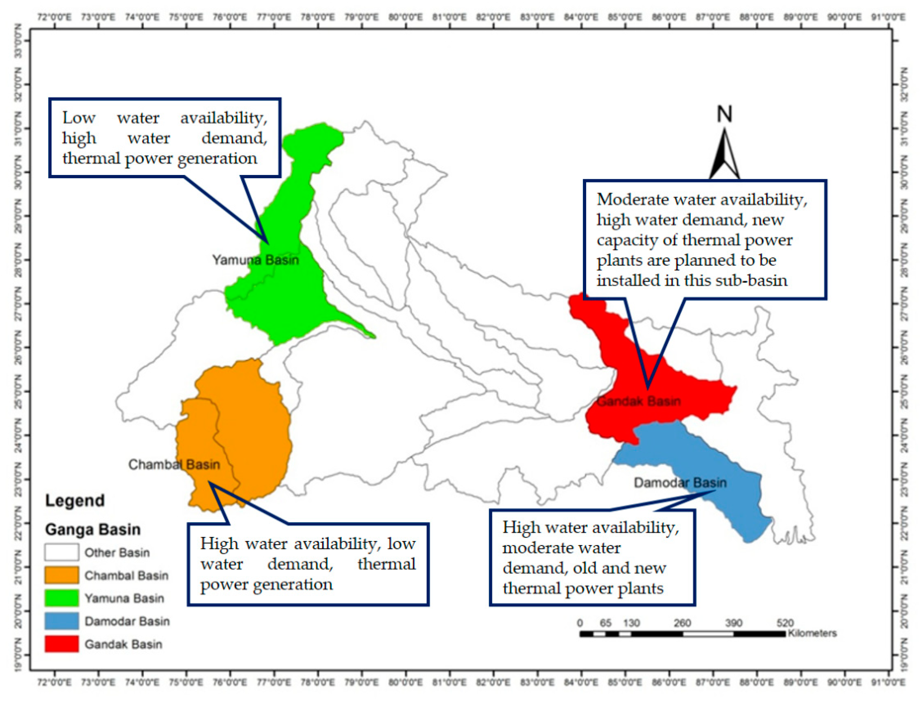
2.1. Study Area
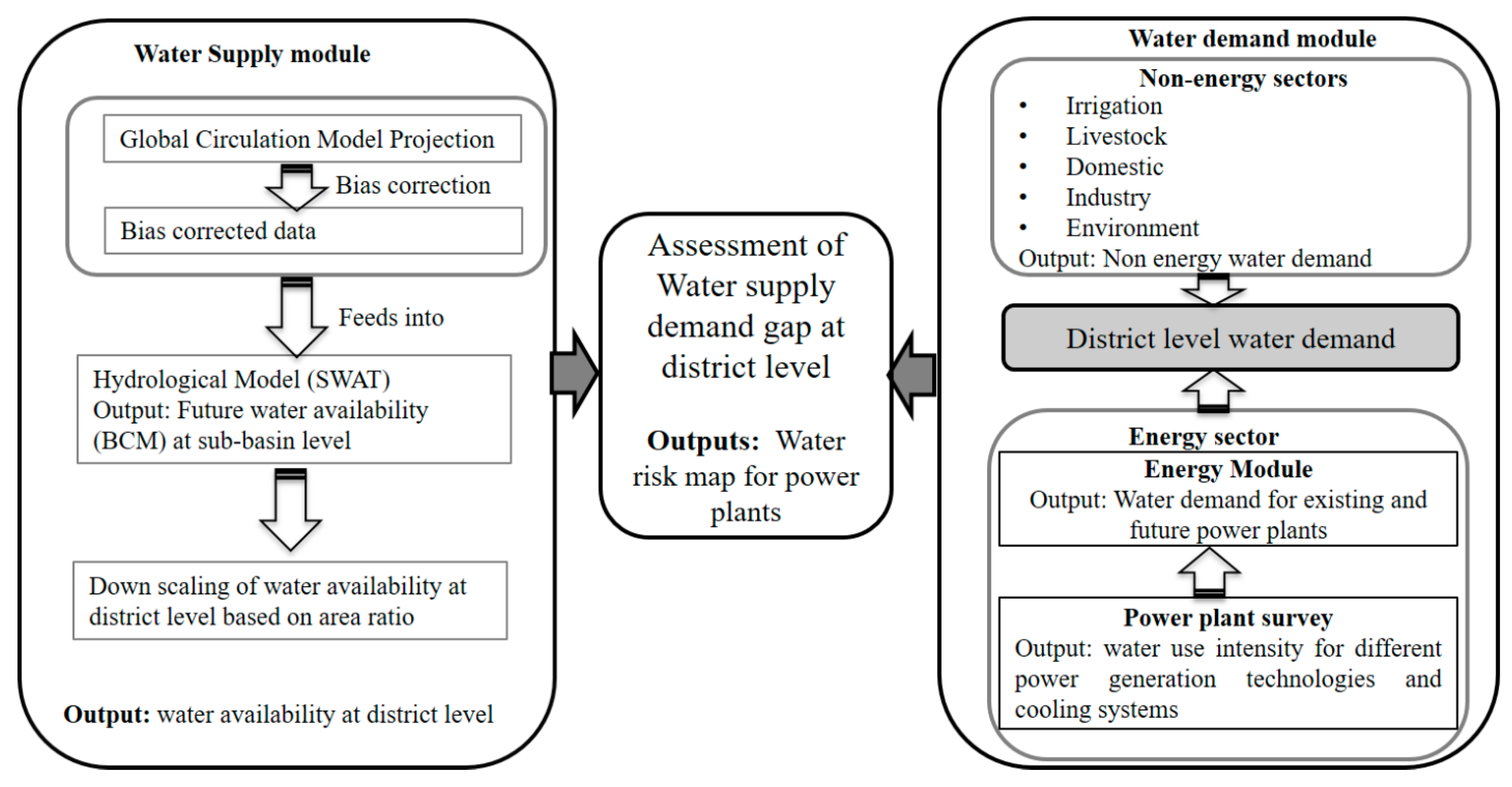
2.2. Methodological Framework
2.3. Water Resource Variability Assessment
2.4. Estimation of Water Demand
2.4.1. Water Demand for Domestic Use
2.4.2. Water Demand for Irrigation
Reffective = 80% × Rtotal − 25, if Rtotal > 70 mm
2.4.3. Water Demand for Livestock
2.4.4. Water Demand for Industry
2.4.5. Environmental Water Requirement
2.4.6. Energy Water Demand Estimation
2.5. Water Risk Assessment for Future Power Generation
3. Results and Discussions
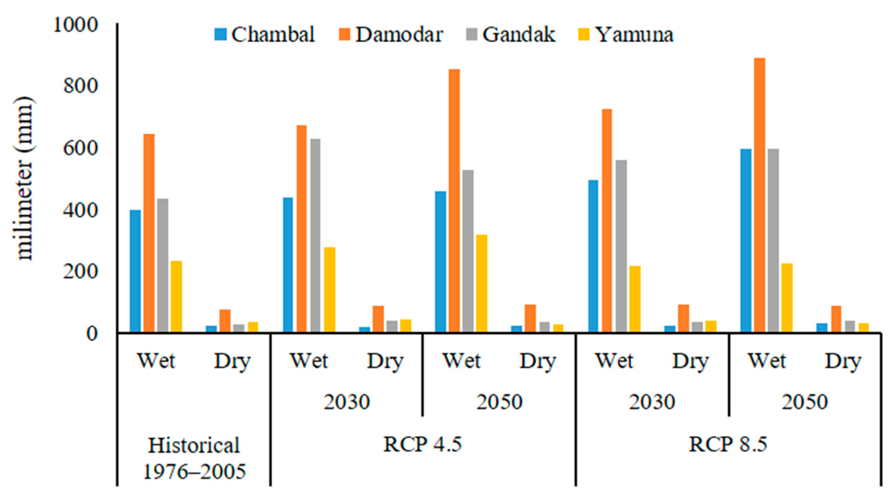
3.1. Climate Parameters under RCP 4.5 and RCP 8.5
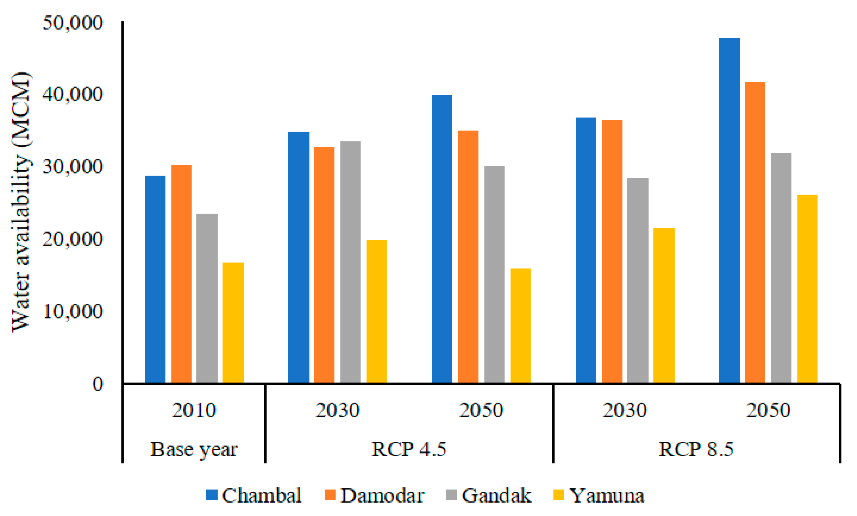
3.2. Water Availability Assessment under Climate Change Scenarios
3.3. Water Demand Assessment
3.3.1. Water Demand of Non-Energy Sectors
3.3.2. Water Demand of Energy Sector
3.4. Assessment of Water Risks to Future Power Plants
4. Conclusions
Author Contributions
Funding
Acknowledgments
Conflicts of Interest
Appendix A
| Power Plants in Sub-Basins | Fuel | Capacity (MW) | Cooling Technology | Operation Status |
|---|---|---|---|---|
| Chambal | ||||
| Kota Super Thermal Power Station | Coal | 1240 | Wet-closed loop | Operational |
| Chhabra Thermal Power Plant | Coal | 2320 | Wet-closed loop | Operational |
| Anta Thermal Power Plant | Gas | 419 | Wet-closed loop | Operational |
| Damodar | ||||
| Koderma Thermal Power Station | Coal | 1000 | Wet-closed loop | Operational |
| Patratu Thermal Power Station I | Coal | 880 | Wet-closed loop | Operational |
| Patratu Thermal Power Station II | Coal | 4000 | Wet-closed loop | Planned |
| Bokaro B Thermal Power Station | Coal | 500 | Wet-closed loop | Planned |
| Tenughat Thermal Power Station | Coal | 420 | Wet-opened loop | Operational |
| Mejia Thermal Power Station | Coal | 2340 | Wet-closed loop | Operational |
| Kolaghat Thermal Power Station | Coal | 1260 | Wet-closed loop | Operational |
| Durgapur Steel Thermal Power Station | Coal | 1000 | Wet-closed loop | Operational |
| Santaldih Thermal Power Station | Coal | 500 | Wet-closed loop | Operational |
| Chandwa Power Project Phase I | Coal | 1080 | Wet-closed loop | Construction |
| Tori power plant Unit 1 | Coal | 1800 | Wet-closed loop | Construction |
| Raghunathpur Thermal Power Station phase I | Coal | 1200 | Wet-closed loop | Construction |
| Gola power station Unit I and II | Coal | 126 | Wet-closed loop | Operational |
| Gandak | ||||
| Kahalgaon Super Thermal Power Station | Coal | 2340 | Wet-closed loop | Operational |
| Nabinagar Super Thermal Power Project | Coal | 1980 | Wet-closed loop | Construction |
| Kanti Thermal Power Station | Coal | 610 | Wet-closed loop | Operational |
| Banka Power Project Stage I (Unit 1 and 2) | Coal | 2320 | Wet-closed loop | Construction |
| Barh I power station | Coal | 1980 | Wet-closed loop | Construction |
| Barauni power station Unit 8 | Coal | 250 | Wet-closed loop | Operational |
| Yamuna | ||||
| IPGCL-Gas Turbine Power Station | Gas | 270 | Wet-opened loop | Operational |
| NTPC- Faridabad Thermal Power Plant | Gas | 430 | Wet-closed loop | Operational |
| Panipat Thermal Power Station I and II | Coal | 1360 | Wet-closed loop | Operational |
| Panipat Thermal Power Station I and II Unit 9 | Coal | 800 | Wet-closed loop | Planned |
| Dholpur Thermal Power Station | Gas | 330 | Wet-closed loop | Operational |
| Chambal | Damodar | Gandak | Yamuna | ||||||
|---|---|---|---|---|---|---|---|---|---|
| District Code | District Name | District Code | District Name | District Code | District Name | District Code | District | District Code | District |
| Ch_01 | Baran | Da_01 | Bankura | Gd_01 | Aurangabad | Ya_01 | Agra | ||
| Ch_02 | Bhilwara | Da_02 | Barddhaman | Gd_02 | Banka | Ya_02 | Aligarh | Ya_34 | Shimla |
| Ch_03 | Bhopal | Da_03 | Bokaro | Gd_03 | Begusarai | Ya_03 | Alwar | Ya_35 | Sirmaur |
| Ch_04 | Bundi | Da_04 | Chatra | Gd_04 | Bhagalpur | Ya_04 | Auraiya | Ya_36 | Solan |
| Ch_05 | Chittaurgarh | Da_05 | Deoghar | Gd_05 | Chatra | Ya_05 | Baghpat | Ya_37 | Sonepat |
| Ch_06 | Dewas | Da_06 | Dhanbad | Gd_06 | Deoghar | Ya_06 | Bharatpur | Ya_38 | Tehri Garhwal |
| Ch_07 | Dhar | Da_07 | East Midnapore | Gd_07 | Dumka | Ya_07 | Bulandshahr | Ya_39 | Uttarkashi |
| Ch_08 | Guna | Da_08 | Giridih | Gd_08 | Gaya | Ya_08 | Dausa | Ya_40 | Yamuna Nagar |
| Ch_09 | Indore | Da_09 | Haora | Gd_09 | Giridih | Ya_09 | Dehra Dun | ||
| Ch_10 | Jhalawar | Da_10 | Hazaribag | Gd_10 | Godda | Ya_10 | Delhi | ||
| Ch_11 | Kota | Da_11 | Hugli | Gd_11 | Gopalganj | Ya_11 | Dhaulpur | ||
| Ch_12 | Mandsaur | Da_12 | Jamtara | Gd_12 | Hazaribag | Ya_12 | Etawah | ||
| Ch_13 | Neemuch | Da_13 | Koderma | Gd_13 | Jamui | Ya_13 | Faridabad | ||
| Ch_14 | Rajgarh | Da_14 | Latehar | Gd_14 | Jehanabad | Ya_14 | Firozabad | ||
| Ch_15 | Ratlam | Da_15 | Lohardaga | Gd_15 | Khagaria | Ya_15 | Gautam Buddha Nagar | ||
| Ch_16 | Sawai Madhopur | Da_16 | Purba Singhbhum | Gd_16 | Kushinagar | Ya_16 | Ghaziabad | ||
| Ch_17 | Sehore | Da_17 | Puruliya | Gd_17 | Koderma | Ya_17 | Gurgaon | ||
| Ch_18 | Shajapur | Da_18 | Ranchi | Gd_18 | Lakhisarai | Ya_18 | Haridwar | ||
| Ch_19 | Sheopur | Da_19 | Saraikela Kharsawan | Gd_19 | Maharajganj | Ya_19 | Jaipur | ||
| Ch_20 | Shivpuri | Da_20 | West Midnapore | Gd_20 | Munger | Ya_20 | Jhajjar | ||
| Ch_21 | Tonk | Gd_21 | Muzaffarpur | Ya_21 | Jind | ||||
| Ch_22 | Ujjain | Gd_22 | Nalanda | Ya_22 | Karauli | ||||
| Ch_23 | Vidisha | Gd_23 | Nawada | Ya_23 | Karnal | ||||
| Gd_24 | Palamu | Ya_24 | Kinnaur | ||||||
| Gd_25 | Pashchim Champaran | Ya_25 | Kurukshetra | ||||||
| Gd_26 | Patna | Ya_26 | Mahamaya Ngar (Hathras) | ||||||
| Gd_27 | Purba Champaran | Ya_27 | Mathura | ||||||
| Gd_28 | Sahibganj | Ya_28 | Meerut | ||||||
| Gd_29 | Samastipur | Ya_29 | Muzaffarnagar | ||||||
| Gd_30 | Saran | Ya_30 | Panipat | ||||||
| Gd_31 | Sheikhpura | Ya_31 | Rohtak | ||||||
| Gd_32 | Siwan | Ya_32 | Saharanpur | ||||||
| Gd_33 | Vaishali | Ya_33 | Sawai Madhopur | ||||||
References
- World Bank. The National Ganga River Basin Project; World Bank: Washington, DC, USA, 2015; Available online: http://www.worldbank.org/en/news/feature/2015/03/23/india-the-national-ganga-river-basin-project (accessed on 20 January 2021).
- Anand, J.; Gosain, A.K.; Khosa, R.; Srinivasan, R. Regional scale hydrologic modeling for prediction of water balance, analysis of trends in streamflow and variations in streamflow: The case study of the Ganga River basin. J. Hydrol. Reg. Stud. 2018, 36, 32–53. [Google Scholar] [CrossRef]
- Sinha, D. Reviving the Ganga, at the Cost of Its Ecology! 2014. Available online: http://www.indiatogether.org/articles/ganga-river-waterway-reviving-and-impact-on-ecology-environment/print (accessed on 20 January 2021).
- Gaur, A.; Amarasinghe, P. A river basin perspective of water resources and challenges 3. In India Infrastructure Report 2011; Oxford University Press: Oxford, UK, 2011. [Google Scholar]
- Rasul, G. Water for growth and development in the Ganges, Brahmaputra, and Meghna basins: An economic perspective. Int. J. River Basin Manag. 2015, 13, 387–400. [Google Scholar] [CrossRef] [Green Version]
- GoI (Government of India). Ganges Basin; Central Water Commission, Ministry of Water Resources: New Delhi, India, 2014. Available online: http://www.india-wris.nrsc.gov.in/ (accessed on 15 October 2020).
- Moors, E.J.; Groot, A.; Biemans, H.; Scheltinga, C.T.V.; Siderius, C.; Stoffel, M.; Huggel, C.; Wiltshire, A.; Mathison, C.; Ridley, J.; et al. Adaptation to changing water resources in the Ganges basin, northern India. Environ. Sci. Pol. 2011, 14, 758–769. [Google Scholar] [CrossRef]
- Shrestha, A.B.; Bajracharya, S.R.; Sharma, A.R.; Duo, C.; Kulkarni, A. Observed trends and changes in daily temperature and precipitation extremes over the Koshi river basin 1975–2010. Int. J. Climatol. 2017, 37, 1066–1083. [Google Scholar] [CrossRef] [Green Version]
- Jeuland, M. Economic implications of climate change for infrastructure planning in transboundary water systems: An example from the Blue Nile. Water Resour. Res. 2010, 46. [Google Scholar] [CrossRef] [Green Version]
- Maurer, J.M.; Schaefer, J.M.; Rupper, S.; Corley, A. Acceleration of ice loss across the Himalayas over the past 40 years. Sci. Adv. 2019, 5. [Google Scholar] [CrossRef] [PubMed] [Green Version]
- Dyurgerov, M.B.; Meier, M.F. Twentieth century climate change: Evidence from small glaciers. Proc. Natl. Acad. Sci. USA 2000, 97, 1406–1411. [Google Scholar] [CrossRef] [PubMed] [Green Version]
- Miller, J.D.; Immerzeel, W.W.; Rees, G. Climate Change Impacts on Glacier Hydrology and River Discharge in the Hindu Kush—Himalayas A Synthesis of the Scientific Basis. Mt. Res. Dev. 2012, 32, 461–467. [Google Scholar] [CrossRef] [Green Version]
- World Bank Database. Electric Power Consumption (kWh per Capita). Available online: https://data.worldbank.org/indicator/EG.USE.ELEC.KH.PC (accessed on 20 January 2021).
- CEA (Central Electricity Authority). All India Installed Capacity (in MW) of Power Stations. 2015. Available online: http://cea.nic.in/reports/monthly/installedcapacity/2015/installed_capacity03.pdf (accessed on 20 January 2021).
- GOB (Government of Bangladesh). Power System Master Plan 2016 Summary. 2016. Available online: https://powerdivision.portal.gov.bd/sites/default/files/files/powerdivision.portal.gov.bd/page/4f81bf4d_1180_4c53_b27c_8fa0eb11e2c1/(E)_FR_PSMP2016_Summary_revised.pdf (accessed on 15 November 2020).
- Gosain, A.K.; Rao, S.; Arora, A. Climate change impact assessment of water resources of India. Curr. Sci. 2011, 101, 356–371. [Google Scholar]
- Luo, T.; Krishnan, D.; Sen, S. Parched Power: Water Demands, Risks, and Opportunities for India’s Power Sector. Water Resources Institute. 2018. Available online: https://www.wri.org/publication/parched-power (accessed on 22 January 2021).
- Mishra, H.; Denis, D.M.; Suryavanshi, S.; Kumar, M.; Srivastava, S.K.; Denis, A.F.; Kumar, R. Hydrological simulation of a small ungauged agricultural watershed Semrakalwana of Northern India. Appl. Water Sci. 2017, 7, 2803. [Google Scholar] [CrossRef] [Green Version]
- Gosain, A.K.; Rao, S.; Srinivasan, R.; Reddy, N.G. Return-flow assessment for irrigation command in the Palleru river basin using SWAT model. Hydrol. Process. 2005, 19, 673–682. [Google Scholar] [CrossRef]
- Kalcic, M.M.; Chaubey, I.; Frankenberger, J. Defining Soil and Water Assessment Tool (SWAT) hydrologic response units (HRUs) by field boundaries. Int. J. Agric. Biol. Eng. 2015, 8, 1. [Google Scholar] [CrossRef]
- Arnold, J.G.; Srinivasan, R.; Muttiah, R.S.; Williams, J.R. Large area hydrologic modeling and assessment: Part I, model development. J. Am. Water Resour. Assoc. 1998, 34, 73–89. [Google Scholar] [CrossRef]
- Srinivasan, R.; Ramanarayanan, T.S.; Arnold, J.G.; Bednarz, S.T. Large area hydrological modeling and assessment. Part II: Model application. J. Am. Water Resour. Ass. 1998, 34, 91–101. [Google Scholar] [CrossRef]
- SRTM (Shuttle Radar Topography Mission). Global Digital Elevation Model. 2015. Available online: http://glcf.umd.edu/data/srtm/ (accessed on 5 June 2019).
- Raju, K.S.; Nagesh Kumar, D. Ranking of global climate models for India using multi criterion analysis. Clim. Res. 2014, 60, 103–117. [Google Scholar] [CrossRef]
- Van Rooijen, D.J.; Turral, H.; Biggs, T.W. Urban and industrial water use in the Krishna Basin, India. Irrig. Drain. 2009, 58, 406–428. [Google Scholar] [CrossRef]
- Smith, M. Manual for CROPWAT; Version 5.2; FAO: Rome, Italy, 1988; 45p. [Google Scholar]
- Amarasinghe, U.A.; McCornick, P.G.; Tushaar, S. India water demand scenarios to 2025 and 2050: A fresh look. In Strategic Analyses of the National River Linking Project (NRLP) of India, Series 1: India Water Future: Scenarios and Issues; Amarasinghe, U.A., Upali, A., Tushaar, S., Malik, R.P.S., Eds.; International Water Management Institute (IWMI): Colombo, Sri Lanka, 2009; pp. 67–83. [Google Scholar]
- MOEFCC (Ministry of Environment Forests and Climate Change). S.O. 682(E). In The Notification of the Government of India in the Ministry of Environment, Forest and Climate Change Vide Number S.O. 3305(E), Dated the 7th December, 2015. Gazette; Government of India: New Delhi, India, 2015. Available online: http://www.moef.gov.in/sites/default/files/Thermalplantgazettescan.pdf (accessed on 20 January 2021).
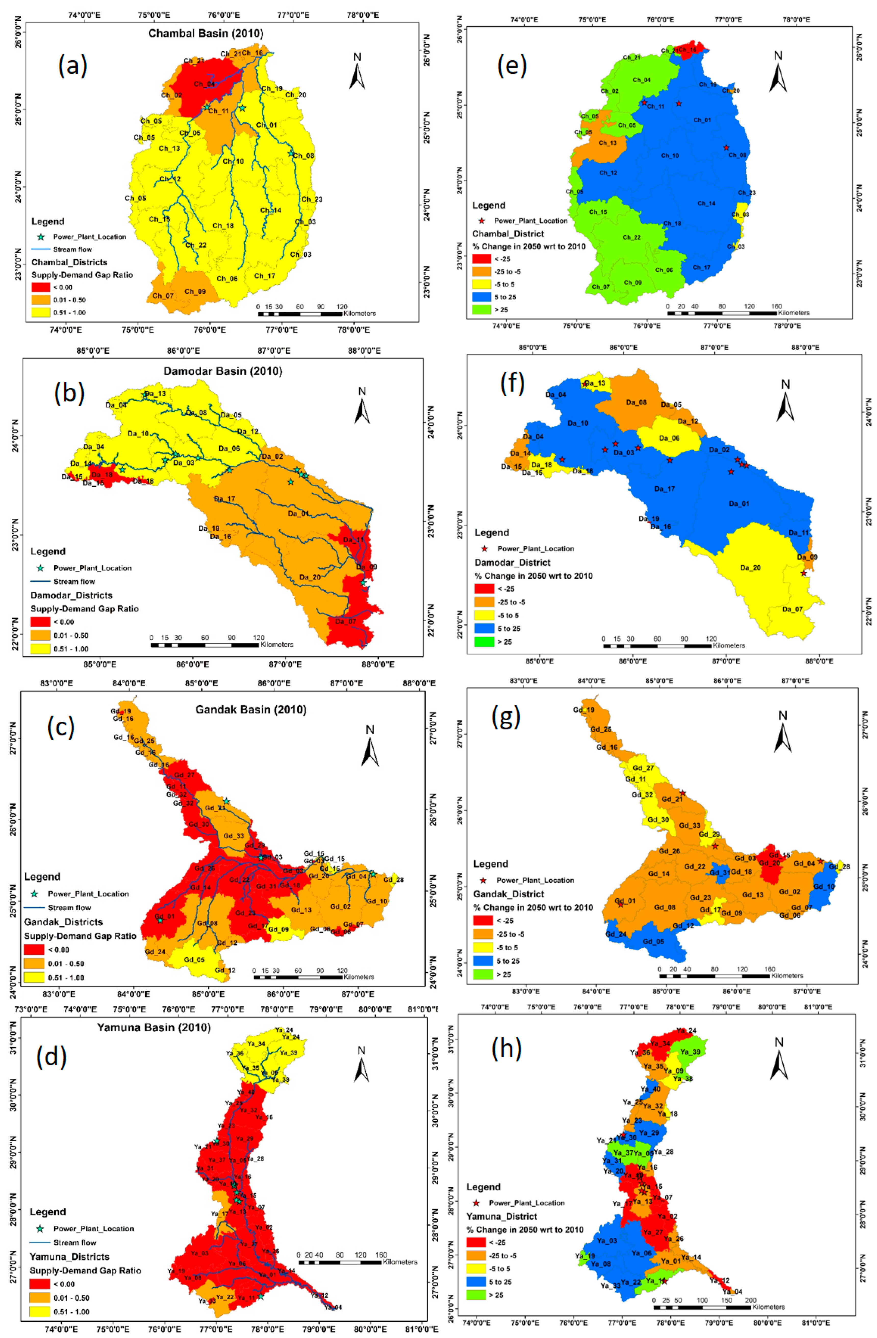
| Level of Changes in the Supply-Demand Ratio (%) | Colour | Description of Level of Effect |
|---|---|---|
| More than 25 | Green | High positive |
| Between 5 to 25 | Blue | Moderate positive |
| 5 to −5 | Yellow | Negligible/No change |
| Between −5 to −25 | Brown | Moderate negative |
| less than −25 | Red | High negative |
| Chambal | Yamuna | Gandak | Damodar | |||||
|---|---|---|---|---|---|---|---|---|
| P | E | P | E | P | E | P | E | |
| Historical | 854 | 443 | 744 | 452 | 1075 | 608 | 1464 | 712 |
| RCP 4.5 | ||||||||
| Near Future (2011–2040) | 940 | 423 | 888 | 512 | 1253 | 653 | 1652 | 793 |
| Mid Future (2041–2070) | 1006 | 533 | 847 | 495 | 1233 | 649 | 1743 | 763 |
| Far Future (2071–2100) | 934 | 468 | 740 | 465 | 1127 | 624 | 1646 | 780 |
| RCP 8.5 | ||||||||
| Near Future (2011–2040) | 1024 | 494 | 775 | 476 | 1175 | 649 | 1661 | 829 |
| Mid Future (2041–2070) | 1119 | 504 | 941 | 517 | 1318 | 665 | 1829 | 832 |
| Far Future (2071–2100) | 949 | 482 | 862 | 515 | 1335 | 661 | 1850 | 849 |
| Water Demand | Base Period 2010 | Change in 2050 |
|---|---|---|
| Chambal | ||
| Domestic | 725 | 635 |
| Industry | 113 | 133 |
| Livestock | 189 | 88 |
| Irrigation | 8895 | 2927 |
| Environment | 125 | 47 |
| Total | 10,112 | 3828 |
| Damodar | ||
| Domestic | 925 | 625 |
| Industry | 123 | 106 |
| Livestock | 200 | 93 |
| Irrigation | 20,281 | 6672 |
| Environment | 273 | 92 |
| Total | 22,099 | 7589 |
| Gandak | ||
| Domestic | 1375 | 1441 |
| Industry | 139 | 163 |
| Livestock | 218 | 101 |
| Irrigation | 22,688 | 7464 |
| Environment | 306 | 116 |
| Total | 24,796 | 9285 |
| Yamuna | ||
| Domestic | 2291 | 2728 |
| Industry | 446 | 621 |
| Livestock | 333 | 154 |
| Irrigation | 23,437 | 7711 |
| Environment | 333 | 140 |
| Total | 26,940 | 11,354 |
Publisher’s Note: MDPI stays neutral with regard to jurisdictional claims in published maps and institutional affiliations. |
© 2021 by the authors. Licensee MDPI, Basel, Switzerland. This article is an open access article distributed under the terms and conditions of the Creative Commons Attribution (CC BY) license (https://creativecommons.org/licenses/by/4.0/).
Share and Cite
Mitra, B.K.; Sharma, D.; Zhou, X.; Dasgupta, R. Assessment of the Impacts of Spatial Water Resource Variability on Energy Planning in the Ganges River Basin under Climate Change Scenarios. Sustainability 2021, 13, 7273. https://doi.org/10.3390/su13137273
Mitra BK, Sharma D, Zhou X, Dasgupta R. Assessment of the Impacts of Spatial Water Resource Variability on Energy Planning in the Ganges River Basin under Climate Change Scenarios. Sustainability. 2021; 13(13):7273. https://doi.org/10.3390/su13137273
Chicago/Turabian StyleMitra, Bijon Kumer, Devesh Sharma, Xin Zhou, and Rajarshi Dasgupta. 2021. "Assessment of the Impacts of Spatial Water Resource Variability on Energy Planning in the Ganges River Basin under Climate Change Scenarios" Sustainability 13, no. 13: 7273. https://doi.org/10.3390/su13137273
APA StyleMitra, B. K., Sharma, D., Zhou, X., & Dasgupta, R. (2021). Assessment of the Impacts of Spatial Water Resource Variability on Energy Planning in the Ganges River Basin under Climate Change Scenarios. Sustainability, 13(13), 7273. https://doi.org/10.3390/su13137273


