1. Introduction
Rural areas host a wealth of cultural and natural heritage (CNH) and are home to more than 55% of Europe’s population [
1]. It is well documented that many of these areas are facing high unemployment, low income levels, an aging population, and depopulation. Given that future wellbeing and wealth is uncertain for the remaining rural inhabitants, plans and methods for rural regeneration are a constant focus [
2]. The EU H2020 RURITAGE project has established an approach that demonstrates how rural areas can use their unique CNH as a driving force in achieving sustainable economic, social and environmental development [
3].
The RURITAGE project takes 20 case studies, considered to be Role Models (RMs) of successful heritage-led rural regeneration from Europe, to analyze them and transfer knowledge and learning to a network of Replicators (Rs). Egusquiza et al. [
4] built a multilevel repository of Role Models as best practices that allows for the identification of common features, mechanisms for mobilization of capitals, and required resources that facilitate the replication to the RSs. To support the co-development of the heritage-led regeneration plans in the Replicators, de Luca et al. [
1] have compiled a Community-based Heritage Management and Planning methodology (CHMP) that aims to support the collaboration and co-creation of regeneration planning and to overcome the barriers that hamper participation in decision-making processes. To quantify the success of these RURITAGE interventions and action plans a monitoring framework has been developed which includes a range of Key Performance Indicators (KPI) that Replicators use to measure their success. To complement the KPI framework an additional co-monitoring program has been developed. This program takes a bottom-up approach working with key stakeholders to understand their values.
The aim of this research was to compile a toolkit that would allow for the collection of some of these key stakeholder values, and the objective was to initially trial and co-develop the collection before rollout to the RURITAGE Replicator sites.
There is a growing consensus that understanding the individual, shared, and cultural values are not only desirable, but crucial for successful sustainable management of landscape and their underpinning ecosystem services [
5]. Developed over many decades [
6], the main methodological approaches to measuring environmental values or preferences focus on either (a) monetary metrics where respondents are asking about their willingness to pay, receive, accept or give up some services (WTP), or (b) non-monetary methods that encompass all other multiple and varied methodologies, including observed behavior, stated preference, questionnaires, etc. [
7]. Although monetary approaches offer quantified, easy-to-interpret data that might shed light on the economic costs involved in landscape management, they are often inadequate to investigate the richness and diversity of the whole range of values that people attached to the landscape [
8]. Therefore, over the last decade, there have been an increasing number of studies that emphasize innovative or modified non-monetary or combined methods for landscape value assessment [
7].
Non-monetary valuation is most frequently based on interviews and survey methods [
7]. Although survey methods can produce quantified evidence (e.g., Bryce et al. [
9], conducted a large sample study to reveal multiple Cultural Ecosystem Services (CES)-related benefits associated with marine sites across the UK), they are frequently seen as limited in providing a broader perspective on how people interact and value the landscape.
Qualitative methods, such as interviews, focus, or expert groups, bring a richer understanding of the complexities of the human-environment interactions. In addition, especially such approaches as narrative methods [
10] or art-based dialogue [
11] are helpful in capturing the ambiguity and complexity of human feelings towards the landscape [
7].
Another important approach to identify landscape values is participatory mapping, a map-making process that attempts to make visible the association between places and values; conceived of as meanings recognized by communities of interest [
12]. Participatory mapping tools are often used to understand those relational values that reflect spatio-geographic discontinuities. Mapped values correlate with participants’ attitudes and preferences towards land use, and may reveal existing or emerging land-use conflicts. Moreover, they are frequently associated with those physical landscape features that are generally stable over time, thus the revealed values are likely to be valid at multiple geographical scales [
13]. In most studies participatory mapping is generally used in combination with other monetary or non-monetary methods [
7].
In recent years, there have been a growing number of mobile applications (for smartphones and tablets); developed to make in-the-field participatory mapping easier and more accessible to a broader audience (for overview of the current tools see: Nowak et al. [
14]). With the introduction of smartphones and the ubiquity of their interface with photo sharing (‘social media’) web services (e.g., Flickr, Panoramio, Instagram, etc.), a new data source, geotagged photos, is available. In most projects that have used such data geotagged images are crowdsourced from social media webpages, making the researcher’s work easy, fast, and cost-effective on a comparatively large scale [
15]. A wide variety of metrics has been employed in these studies. For example, behavioral metrics, such as photo density, measure the number of photographs or photo-user-day units in a given geographic location as a proxy indicator of high landscape value and associated CES [
16]. Some authors have attempted content analysis to ‘mine’ additional information using manual or automatic tools. Although manual approaches are highly subjective, they might lead to a deeper understanding of types of values people attach to places [
17]. The use of automatic tools, e.g., machine learning, is arguably more objective, but is heavily biased towards the presence in images of ‘tangible’ objects such as animals [
18].
Summarizing the variety of non-monetary approaches to the valuation process, Kenter [
8] noted that values are contextual, meaning they do not pre-exist the valuation encounter or process, but are better thought of as formed through the interaction in the valuation process. Moreover, values are socially created; they form through a social exchange of knowledge and experience; and are closely linked with a place, identity, and interpretation. Hence Kenter [
8] advocates methods that allow deliberation; rich interaction between researchers and their informants, preferably over some time. In a wider sense, valuation can be understood as a transformative and consensual process that requires various views and voices to come together to develop a shared understanding and dialogue about what matters the most; i.e., values and their local or contextual meanings in space and time [
8].
Additionally, Raymond & Kenter [
19] suggest a further methodological shift in the valuation process towards recognizing the embodiment of ecosystems. Grounded in the theory of embodied cognition, in particular affordance theory (Chemero [
20], Gibson [
21]), embodied ecosystem approaches recognize that human-environment connections, and therefore values associated with a given place, are produced through a web of relations between environment, culture, body, and mind. Furthermore, such a web of relations is highly situational, and ‘actualizes’ the real-time interaction with a place. Finally, embodied ecosystems are dynamic and the values they ‘provide’ change through pathways of interactions between an individual, environment, and culture. This emergent character of values has consequences for valuation research strategies. Namely values should not be generalized, but preferably be elicited through interactive and situated approaches.
In this paper, we present the My Cult-Rural Toolkit that includes various methods allowing expert and non-expert engagement with the landscape valuation process through just such embodied and situated approaches. All the My Cult-Rural Toolkit tools share the principle of gathering valuation data through real-time interaction in a given place, in the form of an art-led participatory workshop or app-based participatory mapping exercise. The tools were explicitly designed to be used outside, in exploratory relation with the landscape. Although all the instructions for tool use recommend scenarios, they are not deterministic, neither are they based on a closed set of field questions and answers. Rather guidance allows for the emergence of stakeholders’ values through interaction and co-creation of knowledge (and data) between participants, facilitators, tools, and the environment. Moreover, most of the tools presented here are designed to be used as group activities, allowing for social knowledge exchange, deliberation and the unfolding discovery of one’s attitudes and values towards the place chosen for workshop or activity setting. The choice of art-led and picture-based techniques was made to engage participants at their personal level, and to help overcome the limitations of over-reliance on reflective language skills in describing their experiences with a place. We argue that providing communities with a toolkit allows them not only to engage more fully with a dialogue on landscape valuation, but also provides them with a methodology to aid decision-making and assessment of changes in their own local communities, and the places that they value or frequent.
2. My Cult-Rural Toolkit
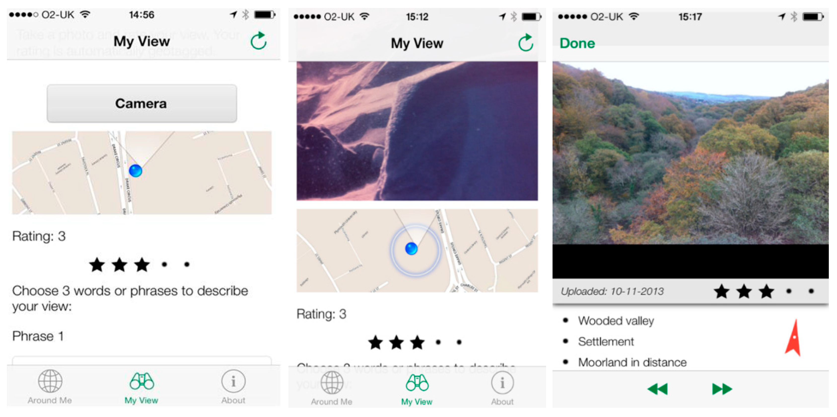
The RURITAGE My Cult-Rural Toolkit has been designed and developed to build capacity within communities in assessing local cultural, natural, and heritage landscape values. The toolkit combines community workshops with ubiquitous mobile phone technologies to extend the reach of the engagement. These two approaches to data gathering comprise (a) Physical tools based around three participatory workshop methodologies: Mini-Landscapes, Object Mapping and Walking Maps, and (b) Digital tools that use two participatory mapping methods facilitated by mobile phone (tablet) apps: Rate my View (RmV) and Landscape Connect (LC). The mobile phone applications (apps) are available for the two major mobile platforms: Android and iOS that together comprise over 99% of global operating system market share [
22].
The participatory workshop methods (Mini-Landscape, Object Mapping and Walking Maps) mobilize participants’ involvement in building local knowledge and understanding the research site or workshop location through collective inquiry, collaborative actions, and shared reflection. The tools comprise guidelines and materials for planning and running hands-on workshops with small groups of local participants. The collected evidence is primarily qualitative, offering an understanding of the participants’ unique experiences. Results can be used immediately with workshop groups on-site, or recorded, coded and analyzed later for more theoretical value-based interpretation, or for the derivation of landscape-based (cultural) ecosystem services. The degree of data collection and analysis will depend on context-specific research objectives. The activities were developed to offer opportunities for research design at many levels of theoretical or practical complexity, and more importantly to varying degrees of stakeholder co-involvement in research design, application, and interpretation.
The participatory mapping methods, Rate my View (RmV) and Landscape Connect (LC), combine participatory research methods with geographic information systems (GIS). The tools are explicitly designed for use in the field by both researchers (facilitators) and participants using robust, portable, and familiar mobile devices or tablets.
The mobile tools both allow real-time collection of data, and thus permit workshop facilitators to make quick analyses that can be used to reflect results to participants, modify procedures on-the-fly, stimulate richer valuation encounters, and hence allow for more robust data and research outcomes. This is theoretically important where environmental or place-based values are invoked since current thinking holds that it is better to consider values as relational and formed through the deliberative processes of the valuation encounter [
8,
23], in direct interaction with the landscape [
19]. This contrasts with rather outmoded but still much-cited conceits of values as universal and organically formed or held (internalized) [
24,
25]. Rather than the binaristic opposition between intrinsic values (deeply held, stable, and relatively unchanging) or, utilitarian values (shallowly held, labile, and even opportunistic), constructivist approaches recognizes that values are always discursively produced and reproduced contextually (in time and space) [
26], and that even the valuation encounter framed as a paradoxically value-neutral process can be challenged as a methodological myth. The term ‘myth’ as used in discourse analysis refers not to a normative judgement of truth/non-truth status but to a process, belief, or assumption that has become so ubiquitous that it often remains procedurally unchallenged as ‘taken-for-granted’, or naturalized [
27,
28].
The GIS function of the mobile tools allows for mapping of the spatial distribution of values or cultural ecosystem services and their linkage to images taken by participants in the field. Both apps are therefore suitable for recording individual, and cumulative subjective or shared experiences from actual sites of inquiry, rather than merely talking about a remote site, which is the most common environmental workshop scenario. Furthermore, the apps and MyCult Rural Toolkit scenarios encourage mobile users to choose where they will go to record data to submit to a study, workshop, or partnership project, thus opening exercise to serendipitous results, or less-biased data recording.
4. Case Studies—Co-Development of Tools
The My Cult-Rural Toolkit was developed for the Horizon 2020 RURITAGE project (European Union, 2020), but before rollout to project partners the tools were developed through a variety of scenarios, with a range of communities from different cultures and countries. Testing through co-development ensured that the tools were suitable for the collection of data within different communities. The communities involved in the piloting of the physical tools have included multicultural and intergenerational co-creators.
Many of the following pilots and test workshops were intentionally sited in a rural context since the RURITAGE project has explicit projected outcomes relevant to sustainable development of rural areas.
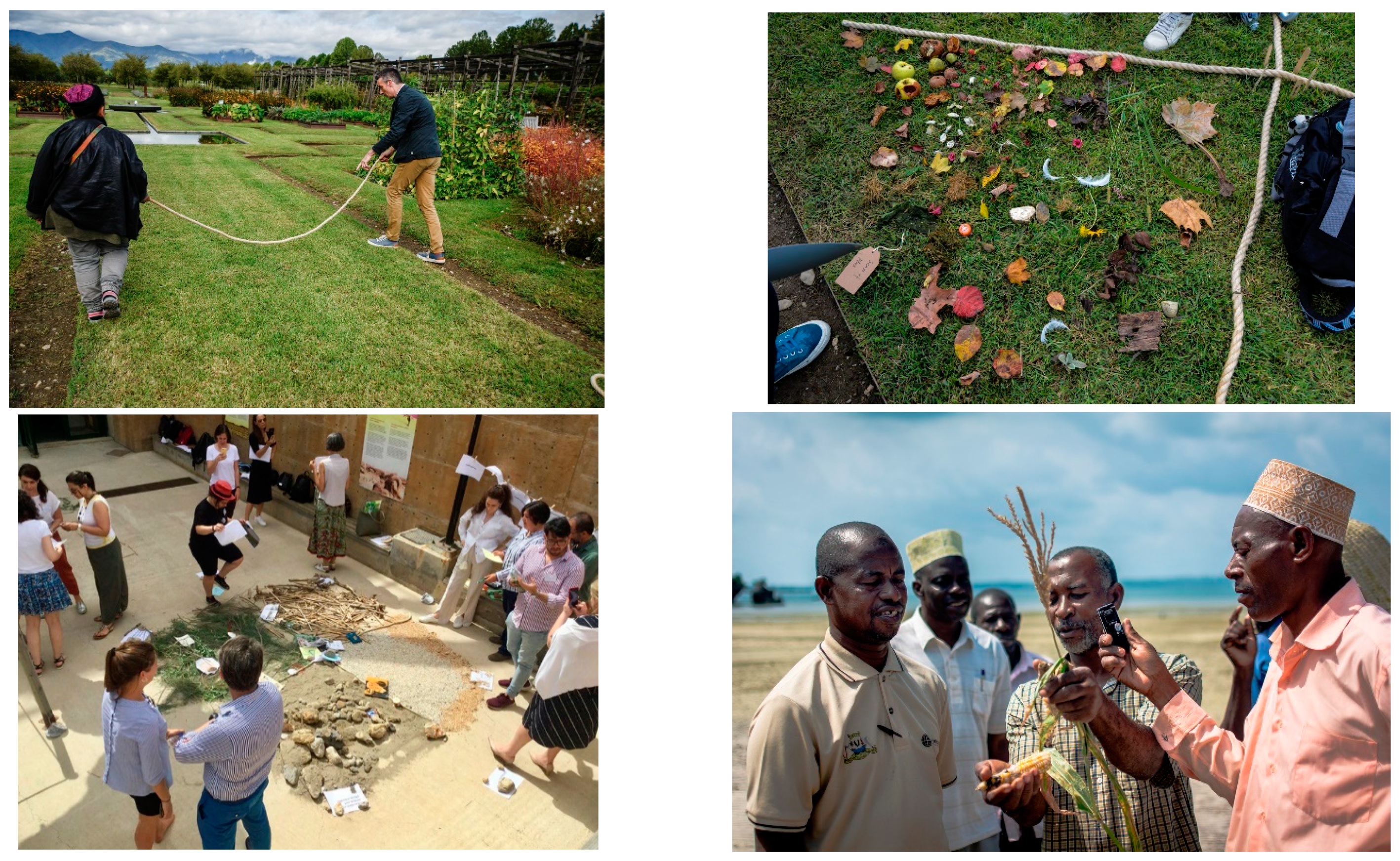
For instance, twenty-year-old, university-educated Hindu participants in Mauritius helped develop the Walking Maps tool through addressing environmental coastal issues, for the project Coral Communities [
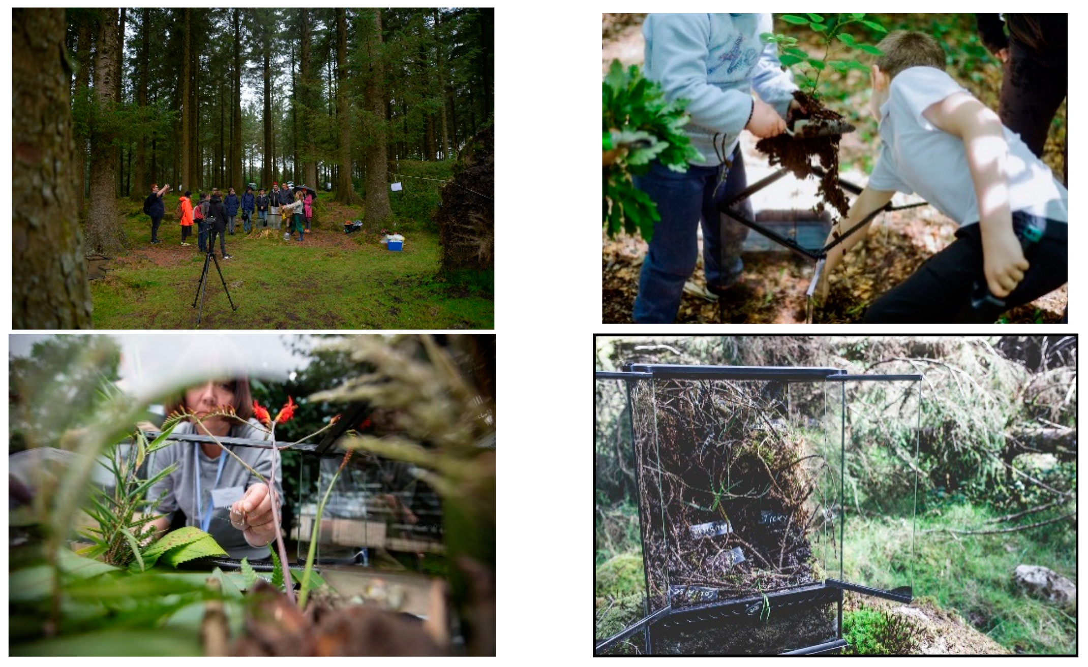
31]. Participants carried out the Walking Maps method by collecting plant material that connected with their childhoods as well as their current heritage and wellbeing within an area protected from development. Material and data from the exercise were exhibited the same day to representatives of the Mauritian government and West Indian Ocean delegates. Beyond tool development, the exercise had the concrete aim of highlighting local values, in parallel with other novel and more conventional visual methods.
Intergenerational participants (5–75) from a deprived area of Cornwall, UK, used the tools to address issues associated with local heritage sites at risk. The workshop provided valuable outputs and data to inform grant applications, to inform community decision-making processes, and aid future access to the site and knowledge about the site.
The Object Mapping tool was originally developed from the Object Elicitation method, pioneered by the project TAGSCAPE, Coral Communities and an NGO called Mwambao Network, and their experienced facilitators [
32].
Figure 2, Bottom right shows a workshop held in a Muslim fishing community on Fundo Island, Zanzibar. This community of about 20 men and woman were asked to place socio-economic objects that they related to the ocean into a resilience grid drawn on the sand near some of their boats.
Tools were further developed through workshopping with 40 RURITAGE project partners. Collaborators later become the facilitators for the rollout of the My Cult-Rural Toolkit within RURITAGE European project areas. For example, the Object Mapping tool was tested in Crete, with each quadrant, reflecting different ecosystem services. (See
Figure 2, Bottom right.) The services were elicited following a tour by workshop participants of local heritage sites.
The Mini-Landscapes tool was originally developed for the TAGSCAPE project [
33,
34]. Fourteen schoolchildren of mixed age were engaged in a Mini-Landscape workshop set in a woodland context, but as part of a bicycling activity (see
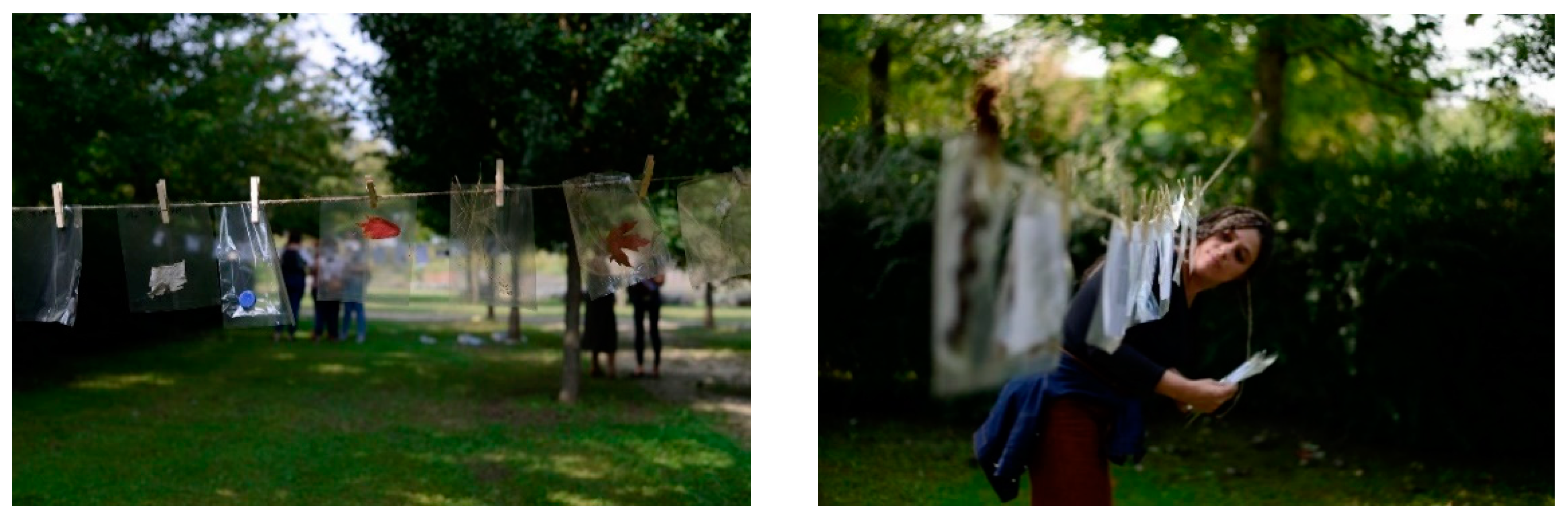
Figure 1, Top right). The young children clearly understood the concept of making a Mini-Landscape and thoroughly engaged with the task. Several parallel workshops were run with young adults (further and higher education) in different types of woodland.
In addition to the communities identified, the tools have been trialed at several academic conference and summer schools. For example, at the 2017 Land/Water and the Visual Arts symposium of the University of Plymouth that explored environmental questions through the subject of ‘Territories’, and under the guidance of filmmaker and academic Kayla Parker (organizer of the event). Through preparing theoretical as well as material conceits the Mini-Landscape tool was used to involve participants in consideration of a ‘new-materialist’ approach that calls for equity in valuing materials used to make, and textual comments made about, participants’ own constructed mini-landscapes.
All the physical tool methods have also been tested at International Summer Schools (Learning by Game Creation, 2019; Cities, Cultural Heritage, and Digital Humanities, Torino, 2018). For each summer school approximately 15 international PhD students with studies relating to heritage issues took part in Mini-Landscape, Object Mapping, and Walking Map workshops situated in a historic garden. Students contributed ideas, enthusiasm and critique from a disciplinary position to complement the co-development of the tool in target communities [
35].
The digital tools (Rate my View and Landscape Connect) have seen active use and refinement in several projects and activities that precede the My Cult Rural Toolkit.
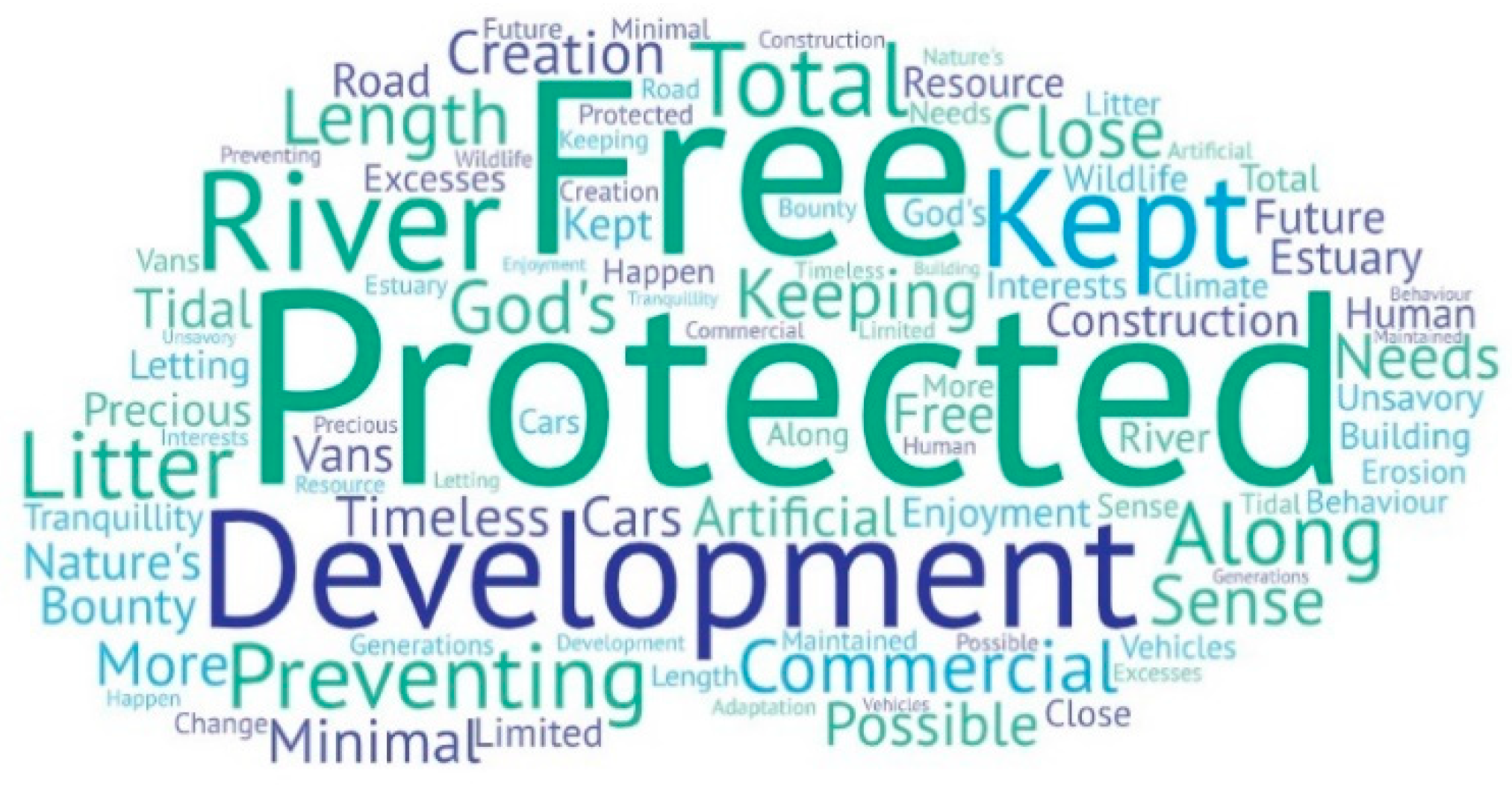
For example, Rate my View was used as part of landscape management project with the South Devon Area of Outstanding Beauty (AONB) and in a Seascape Character Assessment [
36] that collected 116 submissions of photographs and comments from local communities.
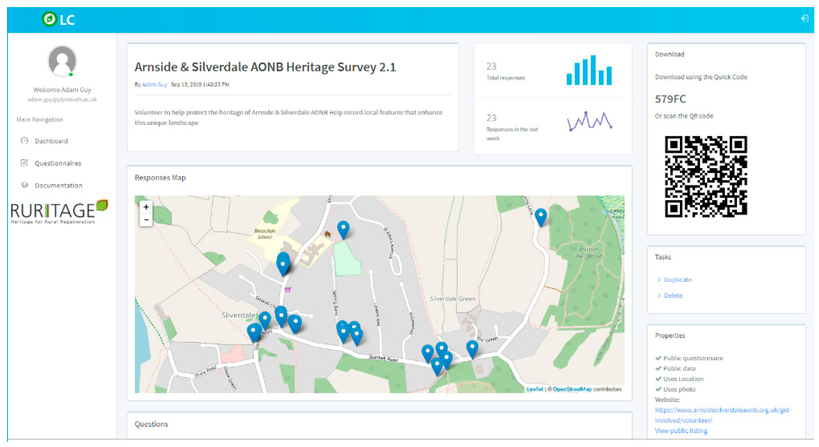
The Landscape Connect digital tool is under active co-development through involvement in various national and international projects. In the Arnside and Silverdale AONB, UK, the tool was used in workshops to collect heritage features that are otherwise unrecorded by local authority monitoring. In Mauritius, community data were collected on the impact on coastal environments (especially Mangrove swamps) of the COVID-19 Lockdown, and a significant oil spill. In a Peru-based study of water quality [
37], and throughout multiple RURITAGE European sites, the tool was used to construct tailored geolinked questionnaires. In all cases feedback from users and facilitators was actively encouraged and used to improve functionality of the app and methodologies for its use.
5. Discussion
One of the biggest challenges while evaluating landscape remains finding methods that facilitate gathering views on the landscape at various scales of engagement and social participation [
38]. In this paper, we present the My Cult-Rural Toolkit that includes a range of methods that allow non-expert engagement through active, place-situated approaches. We argue that providing rural communities with a toolkit allows them to not only engage fully with a dialogue on landscape evaluation, but also provide them with a methodology for decision-making and assessment of the changes in their local communities. Moreover, the My Cult-Rural Toolkit can be adapted to a range of size and age groups. By providing communities with training on how to use the toolkit, we advocate for participatory knowledge making within communities and for the application of the ethical principles of open science.
With the My Cult-Rural Toolkit, we propose an embodied approach for studying the human experience of the landscape. We suggest that gathering data while interacting with the place allows a more direct access to people’s perspectives and can contribute to reducing the normative effects of pre-formed or naturalized value positions. Carpiano [
39], in his ‘go-along’ approach, noted that such methods offer a better understanding of how place and space matter for individuals and communities by assessing the local-area context, refining the understanding of the place and its meaning for the lived experience, and offering a means of engaging communities in participatory research and the co-production of knowledge. In the My Cult-Rural Toolkit, both participatory workshops (Physical tools) and app-based (Digital tools) and methods are intended to be run in places of interest, emphasizing the importance of interaction with space and reflecting while exploring.
Edwards et al. [
11] suggest an ‘arts-led dialogue’ as a critical alternative to more traditional approaches to landscape evaluation by allowing participants to realize new insights and understand experiences that might otherwise be difficult for them to connect with using more logico-linguistic approaches. In particular, art-making approaches and storytelling can help elicit how a place can make someone feel [
40]. The participatory workshop methods of the My Cult-Rural Toolkit offer various modes for participant engagement with the sites and their broader contexts. They all emphasize exploration, feelings, and personal relationship with space. Although the Walking Maps activity concentrates on the individual experience of the site, the Mini-Landscapes activity encourages group-making and collective reflection. In comparison, the Object Mapping activity introduces personal stories by including personal objects and participant reflection on some of the more abstract dimensions associated with landscape, such as ‘wellbeing’ or ‘tourism’.
The digital tools Rate my View and Landscape Connect offer participatory mapping mobile phone applications for collecting people’s values and associated them to an explicit place through GIS data. Previously, participatory mapping has been extensively used to address landscape values [
41,
42], and in particular cultural ecosystem services (CES), such as social values [
13], recreational eco-tourism values [
43], and sense of place criteria. Most participatory mapping studies used online surveys with standard quantitative questionnaires to assess the area or locations of study [
42,
44]. Less frequently used have been qualitative and mixed methods to elicit places values and meanings without a pre-defined typology, or implicit data structure [
45,
46]. Nevertheless, most of these studies are reflective, taking place off-site, without real-time interaction with the place. We argue that bringing participatory mapping methods back into the site might enrich the validity of collected views, as participants record their momentary experience with spaces and places. The success of sustainable development in rural areas requires the consideration of stakeholders’ values and needs. To achieve this requires strong participatory methods that the toolkit will provide. My Cult-Rural Toolkit described in this paper can produce data that can inform a wide variety of value-based ideological and theoretical research design and analysis methodologies. It is also conceivable that the toolkit could be used as an adjunct to landscape-scale valuation projects or frameworks [
47]. Rewilding projects [
48] and Local Nature Recovery Strategies [
49] could also be supported with the RURITAGE My Cult-Rural Toolkit.
5.1. Lessons Learnt and Limitations
The My Cult Rural Toolkit methods were developed through several activities and projects. Therefore, the iterative lessons learnt were integral to refining methods and bringing them together as a coherent toolkit that might meet some of the needs of rural communities undertaking regeneration through a sustainable approach. Some of the key lessons that have shaped the toolkit, and limitations that have been recognized and/or overcome, are discussed below.
5.1.1. Physical Tools
Number of participants: It became obvious that having too many participants within a workshop made the methods unmanageable. Therefore, workshop designers need to both limit individual workshop group numbers and ensure a good ratio of multi-skilled facilitators to participants.
Facilitation mix: The multimodal approach to collecting data requires experienced workshop facilitators to spot, and take on different types of recording roles, and for them to have empathy for different skill sets, different knowledge, and to see potential in participants. It is important to prepare well for assistance and to remember that the participants will become data recorders too.
Different data capture: Young children clearly understand the concept of making a Mini-Landscape and thoroughly engage with the task. With this age group though, the extraction of data from the glass slides was less successful; they were too young to work on their own using such material, or to place words with meaning in the landscapes. On Fundo Island, Zanzibar [
32] although there was no running water or electricity some participants had more than one smart phone and many exchanged SIM cards with dexterity. Thus, the digital tools enabled the creation of recordings of each other by participants, as well as by facilitators, and were found to be just as effective for data collection as was recording on paper, especially as workshops were held outdoors. These types of scenarios emphasized the importance of capturing spoken words as well as visual data, with different types of people and abilities. Important often was the need to work with families to capture rich data about landscape issues from younger participants.
Materialism equals visual data: Each time the tools were tested it affirmed that the participants, the facilitators, the subject matter, the methods used to extract data, and the landscape everyone was standing in were all factors of equal importance. They were all part of the ‘landscape data stage’ [
50]. Additionally, the material of the places in which landscape constructions, object maps, and exhibitions of the walks were held was also found to be important. Raw materials as well as final Mini-landscapes, and comments from participants during the construction process were all recorded and analyzed as potentially significant data.
Embrace the performance: Preparing for workshops involved locating a suitable place in the landscape where participants could ‘see’ different views and had enough ‘room’ to be able to work together. It became clear that each workshop worked best when it was held in a ‘landscape stage’ that had been prepared in advance of workshop days—effectively an outdoor, temporary, mini theatre space. Participants were encouraged to take on subjective roles (as actors in the stage). Thus, if they were able to successfully ‘embody the space’, they were found to be less inhibited in talk about it their subjective relationships with surrounding spaces, and better able share their feelings and knowledge.
Role of visual data: Although the methods used to extract data, were given equal importance, because of the performative nature of workshopping, it was found to be crucial not just to photograph outputs, but also to use participatory video recording. Such methods allowed participating communities to co-develop a richly layered experience using mobile phones, video cameras, and Dictaphones as well as simple interactions with site-specific materials.
5.1.2. Digital Tools
As with all digital technology it was found that simply beginning to use applications and questionnaires presents a significant initial barrier. Workshops structured with facilitated technical and conceptual introductions are therefore essential, and further, facilitation should be extended to an initial ‘pilot’ data gathering exercise. From this point, participants were able to independently collect data, and even take on the role of facilitators to spread data gathering activity to their community peers.
Feedback during workshops was always treated as significant and has helped in making the digital tools more internationally functional (e.g., by adding the capacity to capture diacritically marked characters), less confusing by refining the ambition of questionnaires (by making them shorter and unambiguous in wording), and more effective in data gathering (by appointing ambassadors or champion facilitators from target communities).
Communication strategies: For the digital tools to be successful it is important to have communication strategy that effectively targets key communities. Many collaborators mistakenly thought that simply spreading the existence of a survey, data gathering exercise, or digital tool availability by social media would be sufficient. Invariably such a ‘hands-off’ approach was insufficient. Workshopping and carefully choreographed ‘training’ is essential to ensure uptake of the tool. This must then be followed by targeted promotion that encourages participants to go out and ‘use the tools in their landscapes’.
Hierarchical relationship between tools: The tools were designed to be used independently, or together, therefore there are no hierarchical relationships or statements of preferential use. Choice will depend on workshop context and activities planned.


