Article

Contingency and Agency in the Mountain Landscapes of the Western Pyrenees: A Place-Based Approach to the Long Anthropocene

1
Department of Anthropology, University of Georgia, Athens, GA 30602, USA
2
Laboratoire TRACES-UMR 5608, Université Toulouse-Jean Jaurès, 31000 Toulouse, France
3
Institute for a Sustainable Environment, University of Oregon, Eugene, OR 97403, USA
4
Department of Geography, University of Georgia, Athens, GA 30602, USA
*
Author to whom correspondence should be addressed.
Sustainability 2020, 12(9), 3882; https://doi.org/10.3390/su12093882
Submission received: 14 April 2020 / Revised: 4 May 2020 / Accepted: 4 May 2020 / Published: 9 May 2020

Abstract

:
Regional- and biome-scale paleoecological analyses and archaeological syntheses in the mountain landscapes of the western Pyrenees suggest that the Long Anthropocene began with agropastoral land use at the onset of the Neolithic. Historical and geographic analyses emphasize the marginality of the western Pyrenees and the role of enforced social norms exacted by intense solidarities of kin and neighbors in agropastoral production. Both are satisfying and simple narratives, yet neither offers a realistic framework for understanding complex processes or the contingency and behavioral variability of human agents in transforming a landscape. The Long Anthropocene in the western Pyrenees was a spatially and temporally heterogeneous and asynchronous process, and the evidence frequently departs from conventional narratives about human landscape degradation in this agropastoral situation. A complementary place-based strategy that draws on geoarchaeological, biophysical, and socio-ecological factors is used to examine human causality and environmental resilience and demonstrate their relationship with the sustainability of mountain landscapes of the western Pyrenees over medium to long time intervals.

1. Introduction

We focus in this article on contingency and agency in the “Long Anthropocene” in the Soule Valley of the western Pyrenees, where the Neolithic onset to agropastoral land use during the Middle Holocene marks an important transition in human-environment relations. Whereas the Anthropocene as a unique geological period concerns the sum total of human impacts on the whole earth as a complex system, the Long Anthropocene focuses on spatially heterogeneous shifts in localized human behaviors that ultimately lead to human dominance of the Earth System. An important shift in these localized behaviors is the domestication of plants and animals during the Neolithic and the concomitant transformation of landscapes. Significant effort among proponents of the Anthropocene has gone to identifying a “golden spike” in geophysical archives that would denote the punctuated on-set of human dominance of the earth as a whole, such as the abrupt transition to industrial forms of production, fossil fuels, and intensive global trade networks in the 18th century [1,2,3]. Long Anthropocene proponents have placed more attention on discovering the deep roots of human influence, progressively moving back through time in some instances into the Plio-Pleistocene, while giving attention to social in addition to geological dimensions of the relationship between humans and the earth (e.g., [4,5,6]). Proponents of both approaches have at times formulated deterministic accounts that capture the imagination, and the polemics between them may stem from what is in fact a paradigm shift between environmental science and earth system science [7,8]. We view the approaches as necessary complements and take a Long Anthropocene position in this article to draw attention to the complex dynamics of human-environmental interaction across the temporal and spatial scales at which the relationship unfolds in the western Pyrenees.
The Soule Valley is not a specific locus of plant or animal domestication, yet the localized deployment of agropastoral land use by Neolithic people has had long-term co-evolutionary consequences for both landscape and society. This paper presents a synthesis of our work in the Soule Valley that takes the long-term processes of human-landscape co-evolution as its main subject. The Neolithic transition in the Western Pyrenees is frequently termed a ‘conquest’ [9,10,11,12,13,14] and pastoral activities, including cutting, burning, and shepherding, are said to ‘penetrate’ the land so that the Neolithic is the first step on the orthogenetic path to becoming a global geological force [2]. This narrative of prehistoric land conversion (i.e., “anthropization” in the Pyrenean literature) is closely associated with the presumed inevitability of the degradation of nature brought about by the interaction of humans and environment [15]. By contrast, cross-disciplinary findings presented in this paper indicate that landscape “domestication” in the Soule Valley was not a unidirectional, imperious transformation of mountain landscapes, but an asynchronous, complex, multiscale process associated with individuals as operational change agents. These results are illustrative for research on the Long Anthropocene because they show how a place-based, cross-disciplinary approach can more accurately capture complex dynamics surrounding issues of socioecological sustainability.
Simplistic assumptions about the past trajectories and sustainability of mountain landscapes are not unique to disciplines such as palynology and archaeology. Historians in France have traditionally ignored mountain areas because “…above 1000 m, there is no history” [16]. When mountains have been recognized they are examined indirectly from observations on the plains that surround them [17], resulting in a “quasi-immobile history” [18]. As a consequence, European mountain landscapes and their human inhabitants are perceived as spatially, politically, and economically marginal, which is a conclusion seemingly confirmed by the progressive abandonment of mountain landscapes and the pastoral lifestyle in the 20th century. Whether abandonment is due to marginality or ever-more specialized land-use policies and regulations (e.g., classifying the millennial practice of pastoral fire as irresponsible land stewardship) remains an open question [19,20,21,22]. We argue that speculation of a different kind simply substitutes for understanding of discrete vs. continuous components of a pastoral lifestyle and the nature of human-environment interactions across time.
Pastoralism is a production strategy in which sheep consume grass and transform it with the assistance of a herder into diverse commodities, while enmeshed in a complex interaction between broad-scale drivers, local resources, institutions, and individual agency [23,24,25]. This means that people, place, and history are inextricably linked, while land-use change unfolds as a multi-stranded process of intensification and dis-intensification related to generation-by-generation means and variance in individual reproductive success [26]. Any given household pedigree that holds, transfers, or abandons a portfolio of land parcels is but one realization or historical sample from the full constellation of pathways expressed in a particular population. While convenient to assume equilibrium between reproductive success and migration or between death and survival, to do so obscures the lived reality of agropastoralism that must be apprehended in order to explain how and why change happens.
Our overarching hypothesis is that anthropogenic land transformation in the Long Anthropocene was predominantly a long-term, spatially heterogeneous press dynamic [27] resulting in the sustainable coevolution of land use, socioeconomic intensification, and landscape change, rather than an intentional, uniform wave of agropastoral land conversion. Numerous studies now confirm that European mountain landscapes are the result of climatic and anthropic pressures exerted and interrelated in a variable manner over the course of the Holocene [28,29,30,31,32]. This means that factors of change cannot be separated from factors of location, duration, and intensity [33]. Cultural landscapes such as those in the Soule Valley provide a rare opportunity to examine the origin of structural legacies (long-cycle) and signal processes (short-cycle) that link the past to the present in the anthropogenic transformation of mountain landscapes. We do so by examining the boundaries, scale, and flow in the response diversity of human agents operating under the changing circumstances within a complex adaptive system.

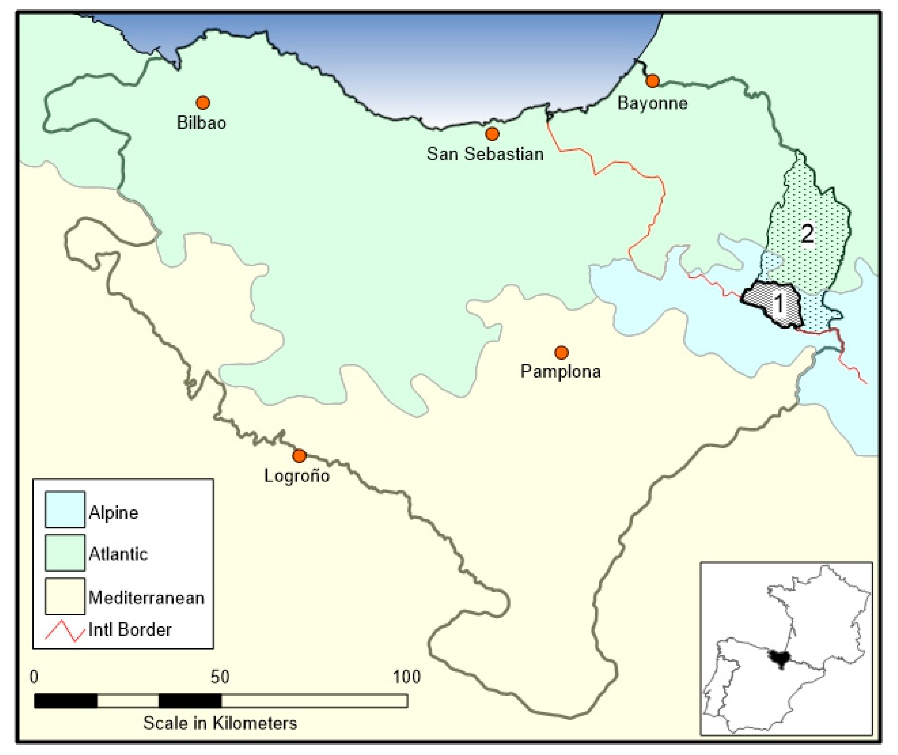
Geographic and Cultural Context of the Western Pyrenees

Our research is centered on the commune of Larrau in the Soule Valley in France (Xiberoa, in Basque). However, the contingency and agency characteristic of agropastoralism has required us to place Larrau within the Soule Valley and the larger Basque region (Euskal Herria) in the western Pyrenees spanning the French-Spanish border. Soule is the smallest of the seven Basque Provinces, and is centered on the Saison River in the French department of Pyrénées-Atlantiques that borders the autonomous community of Navarra in Spain. Despite the modern border between France and Spain, archival research gives evidence that individuals and institutions from both the north and the south slope of the Pyrenees have used its high elevation pastures since at least the High Middle Ages. Indeed, high elevation pastures at the head of the Soule Valley are still used by members of communities outside of Soule, notably Barétous to the east in France and Roncal to the south in Spain (Figure 1).
At the European scale, the Pyrenees Mountains form a continuous barrier to atmospheric circulation [34,35], resulting in strong west-to-east and north-to-south gradients in climate, environment, and human use (See Supplementary S1, Figure S1.1, in Supplementary Files). The western Pyrenees receives significant precipitation (circa (ca.) 1500 mm/y) under the influence of the North Atlantic Oscillation (NAO) and the humid air masses of the north/northwesterly winds. The eastern Pyrenees, by comparison, are much drier (ca. 500 mm/y) and under the influence of a Mediterranean-like climate in which moisture is negatively correlated to the NAO [36,37]. The northward draining watersheds (“north slope”) in France are wetter than the southward draining watersheds (“south slope”) in Spain. The latter borders the Ebro River basin subject to a Mediterranean climate under a strong continental influence with hot summers and cold, dry winters (ca. 300 mm/y) [38]. Consequently, Soule Valley exists at the convergence between the Atlantic, Mediterranean, and Alpine bioclimatic regions and abuts the political border between France and Spain.
Soule as a community is also part of Euskal Herria, where Euskera (Basque), the last non-Indo-European language in Europe, is still spoken as the first language by some 1,300,000 individuals [39]. Archaeological sites from the terminal Pleistocene through the early Holocene within Euskal Herria (Supplementary S1, Figure S1.2) speak to the debated origin of the Basque that are commonly said to have lived in the area bounded by the Adour and Ebro rivers since ‘time immemorial’. Mounting evidence indicates that Euskera is linguistically related to Caucasian languages [40,41,42], suggesting that inhabitants of Iberia and Aquitania adopted the language from the carriers of the ‘Neolithic package’ as they moved up the Ebro Valley. Genome-level evidence suggests that the Basque are close to other Europeans, and even though they display unique Y-DNA and mtDNA lineages, their continuity as a biological population is only detectable back to the Neolithic/Chalcolithic period [43,44,45,46]. The most comprehensive human genetic study for the Franco-Cantabrian region to date [43] identified six unique mtDNA haplogroups autochthonous to the region and estimated that the separation of the Basque-speaking populations from the pan-European gene pool took place ca. 8000 calibrated years before the present (cal BP). The results further suggest a female genetic contribution distinct from other European areas. The implication is that the ‘Neolithic package’ does not indicate demic replacement as some advocate [47], but rather an extended coexistence of Epipaleolithic and Neolithic populations [48,49].
Despite the linguistic and genetic implications of occupational continuity, there are currently no known archaeological sites in the Soule Valley between ca. 14,700 cal BP and 9700 cal BP. However, it seems likely that hunter-gatherer populations residing in the low- and mid-elevation zones of the upper Ebro Basin used the uplands intermittently depending on weather conditions. Agropastoralism in the western Pyrenees and its continuation into the Cantabrian Range dates to the initial Neolithic expansion around the Mediterranean Basin ca. 7500 cal BP [50,51,52,53]. We examine the local socioecological dynamics of the Neolithic expansion and the Long Anthropocene in the headwaters of the Soule Valley in the administrative territory of the commune of Larrau.

2. Materials and Methods

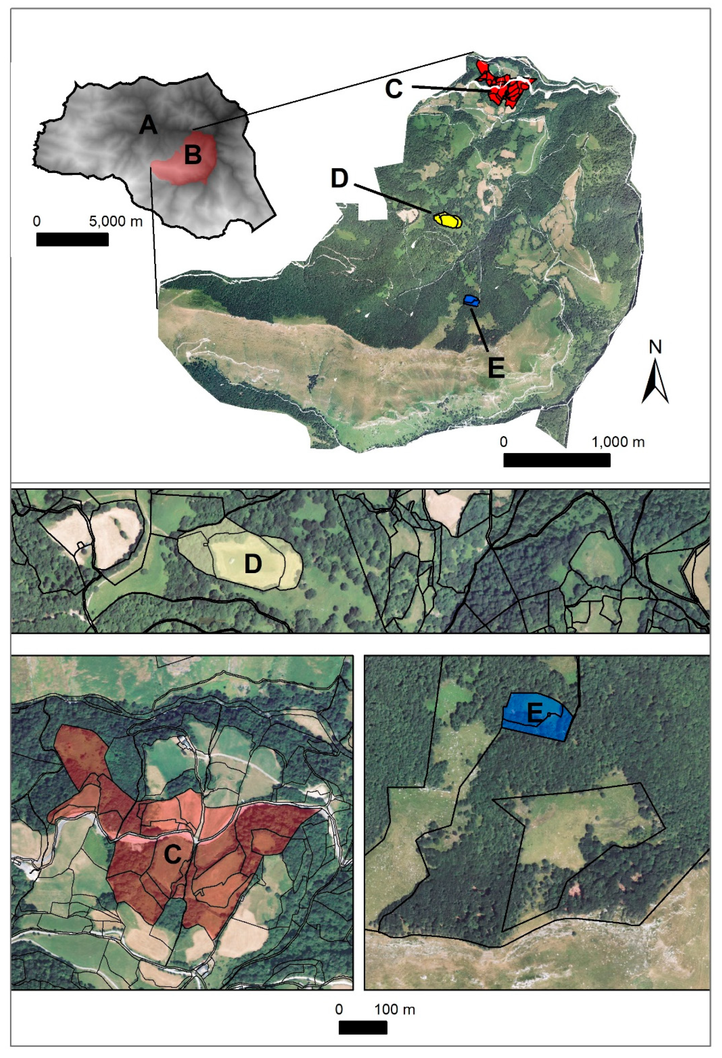
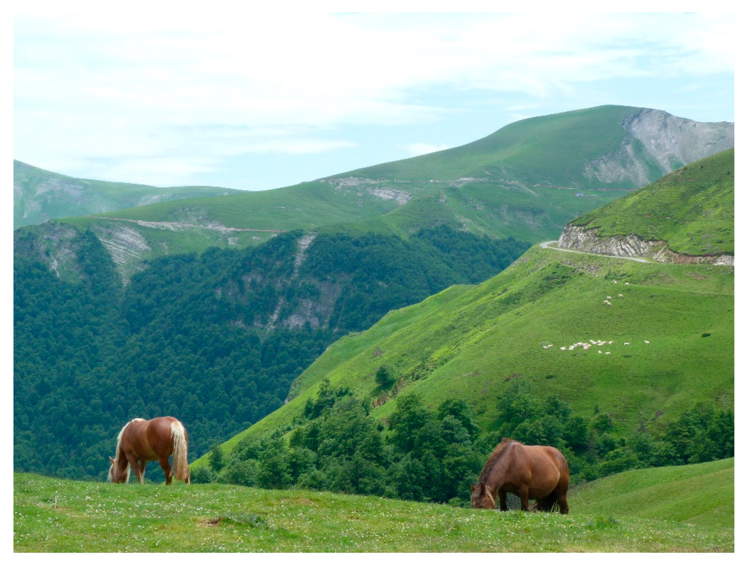
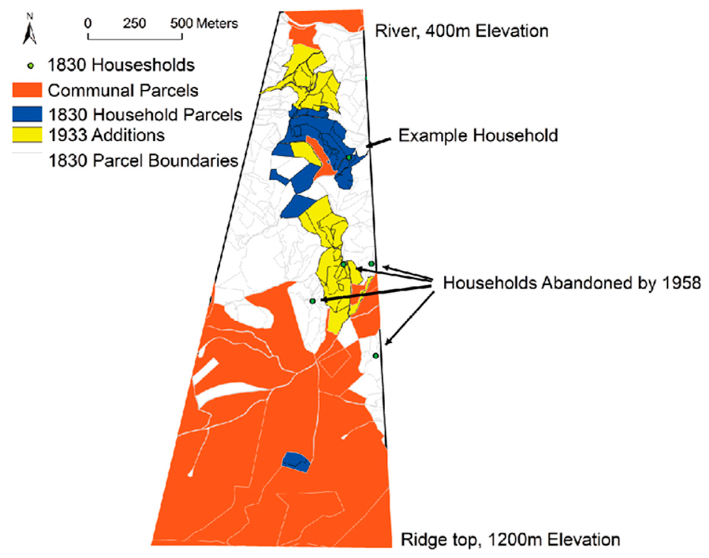
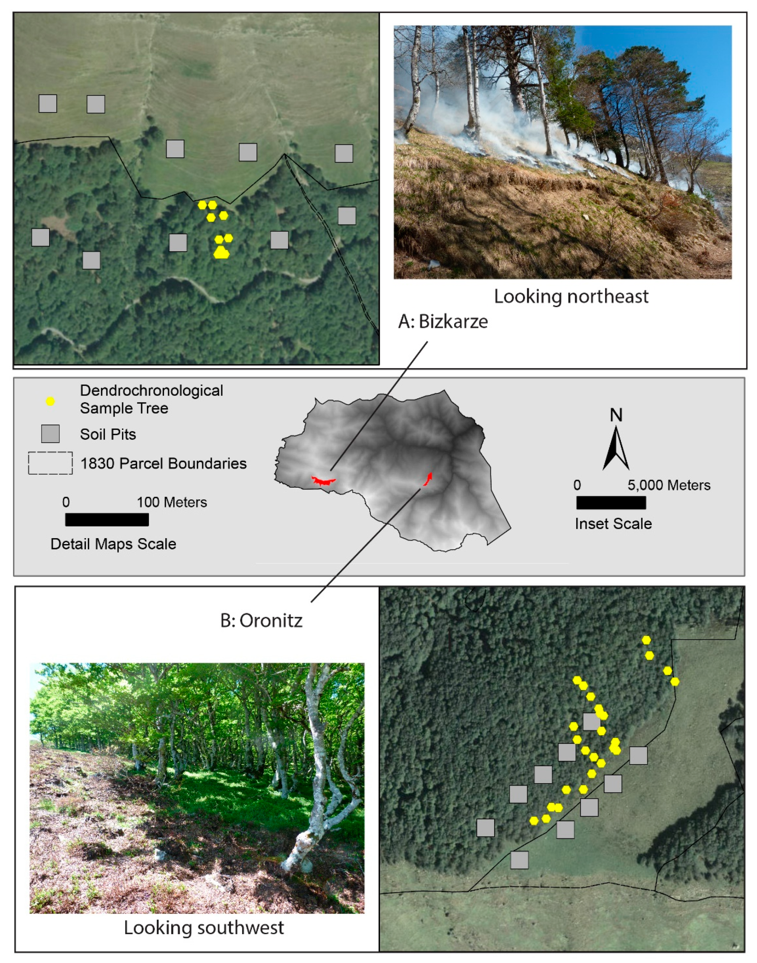
2.1. Soule Valley and Larrau

Over the course of the last decade (2009–2019), we conducted interdisciplinary fieldwork in the communal territory of Larrau, in the Department of the Pyrénées-Atlantiques, France. Larrau has a surface area of 12,680 ha and contains most of the high-elevation pasture used by the 47 communes that presently comprise Soule as a territorial community. Elevations in the commune of Larrau range from 300 to 2000 m above sea level (asl), which is characterized by a cool and humid climate with an average precipitation of 1600 mm/y and average daytime temperature between 1.4 °C (winter) and 13.3 °C (summer) (data available, Météo-France). Land use in the lower elevations corresponds with private household farmsteads, that can either be consolidated or scattered landholdings, depending on the household. Forests below 800 m asl are dominated by oak, which transitions to beech and fir (Abies sp.) between 800 and 1300 m asl. These are predominantly communal woodlands with scattered private “inholdings” representing the upper limit of the privately owned hay meadows. Alpine and subalpine grasslands and heaths with patches of mixed pines dominate elevations above 1300 m asl. These high-elevation grasslands form the bulwark of the communal summer pastures accessed by herders from throughout the Soule Valley.
Landscape within the Soule Valley can be divided into a hierarchical set of socially and ecologically significant spatial units: valley, commune (a village and its territory), quartier (a topographically defined neighborhood), etxe (a household-level farm production unit), parcel (a spatially circumscribed, discrete unit of land use), a borde (an independent cluster of parcels surrounding a barn, often located in the mid-mountain within or between communal and private lands), and a cayolar (collectively owned pastoral inholdings within communal lands) (Figure 2). A valley is comprised of many communes, a commune is comprised of several quartier, a quartier consists of a number of etxe households, and the landholdings of an etxe consist of topographically arranged parcels that provide the unit with diverse resources across the annual production cycle. Pastoralists are often seen as having a separate, peripheral, and marginal existence vis-à-vis sedentary farmers [25]. In the case of the western Pyrenees Mountains this view translates into a perception of the Basque as spatially, politically, and economically marginal since at least Antiquity by comparison to surrounding areas. This view is closely associated with the ‘valley republic’ phenomenon common across the Pyrenees among Aragonese, Basque, Béarnaise, and Gascogne groups (e.g., [54,55]), of which there are approximately 15 among the Basque in the Western Pyrenees. Briefly summarized, these are ethnic enclaves organized by their dependence on agropastoralism and frequently described as systems in existence since time immemorial.
There are two types of land in Soule and the Basque region of France and Spain generally [56,57,58]: (a) parish-community lands belonging to the individual inhabitants of a village “since time immemorial”, and (b) common lands belonging collectively to all parish-community residents in a defined region. In Soule, parish-communities re-defined as communes in the Napoleonic Cadaster of 1830 have been stable since at least AD 1377 based on the first tax-census of the valley [59], and at least five parish-communities have existed since the 11th century [58,60]. This division of the land and its associated administrative and economic autonomy includes diverse aspects of livestock management and provides the holders vis-à-vis a central authority with various rights recognized in customary documents called coutume (French) or fuero (Spanish).
The oldest surviving examples of such documents in the French Pyrenees, e.g., Coutume de Soule, date to the early 16th century [58]. In the Spanish Pyrenees, the Fuero de Jaca is the oldest such document, dated AD 1077, and elements from it were incorporated into a regional management document called the Ordenanza de Pastos, dated AD 1457 [61,62]. Coutume and fuero in the Basque region are anchored in an oral customary tradition termed the Derecho Pirenaico that circumstantial evidence suggests either draws from and/or is influenced by older legal frameworks from the 6th–8th century, if not 1st century Roman code from Gallia Aquitania. The groups of parish-communities who invoke a particular coutume or fuero are historically and colloquially referred to, even at present, as a “country”, “republic”, or “valley”, e.g., Soule. This is a tacit recognition of the shared history, language, culture, and geography that gives identity to parish-communities and residents of a valley. Parish-communities are important at a certain scale, but historical and ethnographic evidence identify the etxe household as the principal locus of production and decision-making [26,63,64].

2.2. Research Design and Synthetic Framework

The overarching goal of our research on the Long Anthropocene in the commune of Larrau and the Soule Valley was to integrate diverse place-based observations to understand the co-evolution of pastoralism and landscapes scaled to the decision-making units responsible for activities on the land. Larrau provided us with a unique opportunity to assemble a long-time series on diverse dimensions of mountain pastoralism. Our approach combined multiple methods and data sources, including qualitative and quantitative analyses of historical archives, geospatial mapping and modeling, ethnographic participant observation and interviews with livestock raisers concerning historic and contemporary grazing and burning practices, archaeological survey and excavation of high-elevation pastures, dendrochronology of forest-meadow edges and ancient coppice woodlands, and paleoecological investigations of sedimentary archives. We used our findings to generate highly resolved chronostratigraphic sedimentary profiles for change in discrete landscape units for the entire Holocene (past 11,700 years), that we related through geospatial analysis to grassland pasture flammability, parcel use, and household abandonment. Since our purpose in this paper is to provide a synthesis of our various analyses, we provide only a summary of our methods below. For full methodological and analytical details, please see our various publications [26,65,66,67,68,69,70].
Humans have unparalleled behavioral plasticity and occupy many habitats that ecologists and development experts would term “marginal”, even if a precise definition of marginality is rarely provided (e.g., [71,72]). Being marginal does not mean an area is uninhabitable or uninhabited, it implies that human culture and technology are unable to buffer against environmental or sociopolitical stressors [73]. In the case of mountains, such a determination cannot be made either by assuming there is no history above 1000 m asl or by inference from the more easily accessible plains that surround them. It requires us to examine system behavior itself and arrive at an understanding of the thresholds, alternative steady states, adaptation, contingency, and feedback that allow and determine the nature of the human relation to the environmental setting in which it is expressed [74,75,76,77,78].
Response diversity or how individuals differentially respond to their changing circumstances is an important component of the central tendency of any described behavior [79]. It is anchored in human agency, that nominally includes intentional, self-aware choice [80,81]. The existence of choice does not imply that human agents are aware of the reasons for their choices, or that they think in terms of costs and benefits regarding fitness or other such measures. Yet, people do make choices expressed in their agency that consider their circumstances and their preferences, and which derive from a developmental process inclusive of inheritance and learning. The weight of pastoral activities expressed in the geoarchaeological record is concentrated on places—a cabin, a corral, etc. However, these places are mere gateways distributed across a pastoral landscape to the exploitation of grass, the key, and almost invariably common resource that is exploited by livestock with the assistance of herders [82]. The implication of this characterization of mountain pastoralism is that to understand the system we must reflect on the boundaries, scale, and flow of the response diversity of the human agents operating within it, while addressing how response diversity can promote stability without resorting to a claim for exceptionalism:
  • Boundaries—identity groups operating within defined territories called ‘valley republics’ that cannot simply be characterized as closed corporate communities, since they coexist within a regional system; these boundaries to pastoral activities must be evaluated as to their closed vs. open, flexible vs. inflexible nature.
  • Scale—members of a herding cooperative (a cayolar) are bound by valley-wide ‘rules of use’ containing multiple levels (e.g., individual, etxe, cayolar, commune, valley) on a scale that must be considered for a proper understanding of system function.
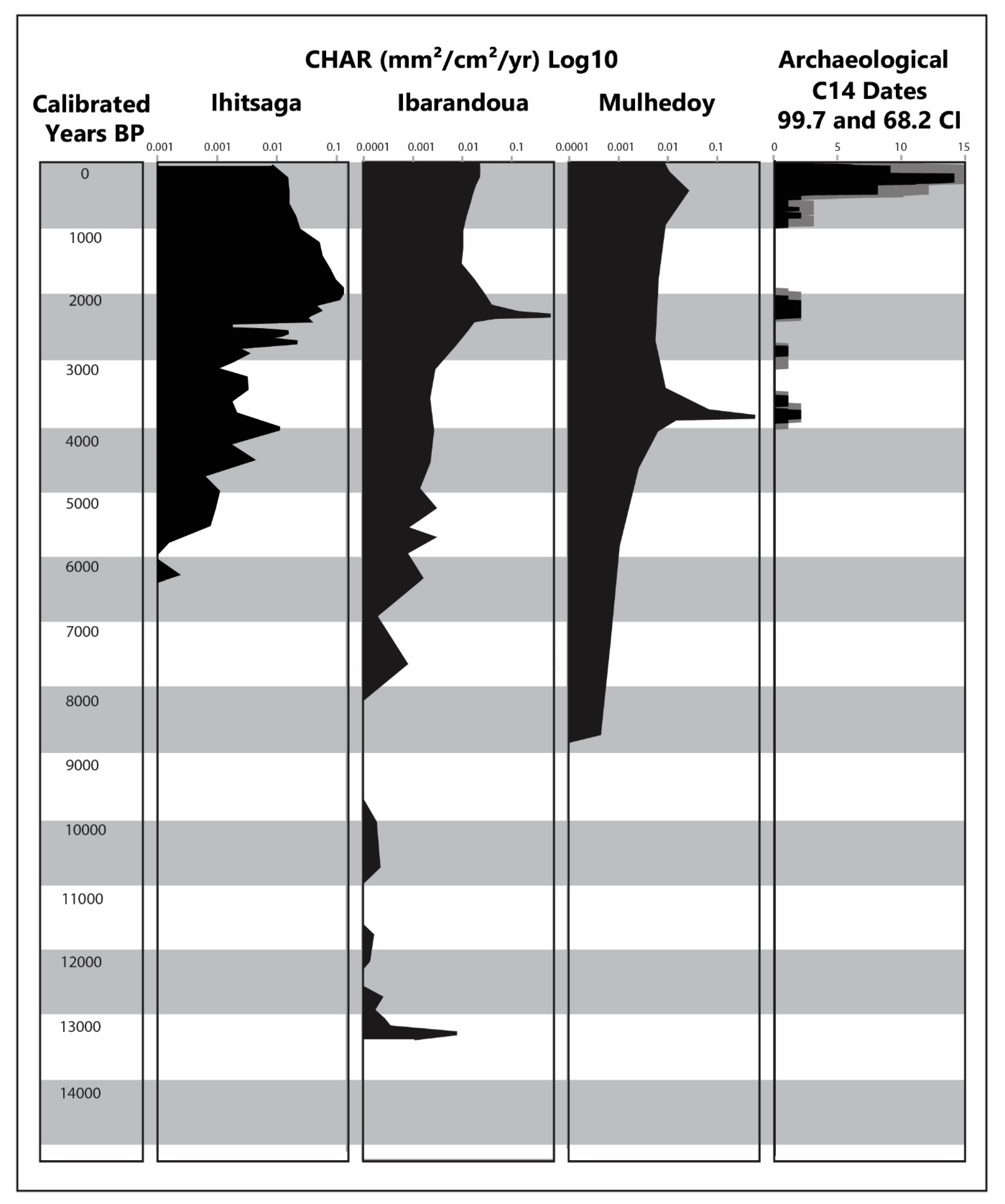
  • Flow—livestock are the means for exploiting the resources, and understanding their flow from/to places is central to evaluating the differential pressure and cumulative effect that stocking rates, for example, can have over time on the structure of archives at places across the landscape. We exemplified these aspects of response diversity during the Long Anthropocene by summarizing paleoecological, archaeological, and historical evidence for upland forest to pasture conversion and land use transition and persistence in Larrau.

2.3. Examining Forest to Pasture Conversion

In the absence of agropastoral land use and management, subalpine forest should cover all but the exposed rockfaces of the highest and steepest peaks in Larrau. Today, very little of the landscape above 1200 m asl is forested (Figure 3). Forest to pasture conversion is the fundamental process for domesticating landscapes in agropastoral systems and fire is the primary tool [65,66]. To examine forest-pasture conversion as a socioecological process in Larrau, we combined archaeologically derived chronologies of agropastoral occupation and colluvial stratigraphic archives of “legacy” sediments from zero-order hollows at locations along the top of the Pyrenean divide. We auger-sampled continuous profiles of colluvial slopewash sediments eroded from zero-order watersheds in 5–10 cm contiguous intervals. We used a multiproxy approach to analyze these sediments, examining charcoal, magnetic susceptibility, sedimentation rates, and phytoliths to characterize the differential onset of anthropogenic burning and forest-pasture transition across individual catchments [69,70,83].
We complemented each colluvial sample with systematic pedestrian archaeological survey of the surrounding catchments. We also conducted ground-penetrating radar surveys at and adjacent to 11 of the archaeological sites we located and followed this with subsurface auger testing [67]. For seven archaeological sites located beneath or adjacent to our zero-order colluvial catchments, we auger-sampled stratigraphic profiles at 5 cm contiguous increments and collected archaeologically-deposited wood charcoal for radiocarbon dating. Additionally, French colleagues conducted excavations of two sites a short distance (<10 and <100 m, respectively) from two colluvial sample sites [68]. Charcoal from these excavations were radiocarbon dated as well.

2.4. Analysis of Land Use Transition and Persistence

Regional studies suggest landscape transitions are primarily driven by “exogenous innovations that originate outside the boundaries of the local system” [84]. However, this approach necessitates that the motivations, decisions, and actions of individual land managers are derived from inferences about the group to which individuals belong, rather than the action of individuals themselves.
In Basque society, etxe households are social and economic reproduction units resulting in the demographic conditions that make the spatially- and historically-contingent economic decisions responsible for local patterns of land use change [85,86,87,88,89]. The etxe is more than just a smallholder family farm. It constitutes a spatially fixed property conceptually independent from a family. This means that normatively, an etxe can be abandoned while the family continues, or a family bloodline can die out while the etxe continues to bring in a new inheritor [63]. Etxe inheritance norms include ambilineal primogeniture and impartibility of the estate of land and buildings [26,90], i.e., the eldest male or female child inherits the entire estate and the right to form a family. The inheritor’s younger siblings stay on as productive yet celibate members of the etxe household, who are beholden to the decisions of the inheritor [63]. Documents from the private archives of etxe in Larrau suggest that a least some of them were established prior to the 16th century.
We developed a geodatabase of fiscal land records from 1830 to the present that covers the entire commune of Larrau. We additionally compiled archival records from household and regional repositories that date back to ca. A.D. 1000 and provide information ranging in scale from the etxe household to the valley level. For one quartier in Larrau, we conducted field- and cadastral-based reconstructions of etxe and parcel-level infrastructure and land use from 1830 to the present. To confirm historical parcel boundaries for the quartier we matched the 1830 cadastral maps with current and historical air photos and conducted pedestrian surveys of parcels, hedgerows, and trails that access them. We additionally conducted a dendrochronological sampling program in the woodlands and hedgerows between communal lands and etxe private parcel holdings of the quartier. Using communal birth records from 1790 to 1950, we reconstructed household-level demographic histories and linked these to our geodatabase of etxe abandonment and parcel-level land use change in the same quartier. Using event-history analysis [26], we examined how agropastoral-focused etxe move at any point in time among a finite and theoretically meaningful number of states (e.g., ‘occupied’, ‘abandoned’) and how parcels flow in and out of dynamically-scaled etxe in response to time-constant or time-dependent factors [91,92].
Above the etxe landholdings (>800 m asl), are lands held in common by the members of a valley republic [93] and used by etxe as summer (May–September) pasture for their livestock [94,95]. Within these communal lands are small, collectively owned inholdings that typically contain a cabin and milking grounds, that together form a traditional grazing cooperative known as an olha (Basque) or cayolar (French) [94]. Ott [94] and others [56,57,58] have described in detail the historical and legal precedents of the cayolar institution, the roles and responsibilities of herders, and the economic and social imperatives of participation.
While extensive archaeological survey of Larrau’s high elevation pastures allowed us to confirm the spatial and functional accuracy of cayolar infrastructure depicted within the 1830 cadastral maps, it did not provide adequate information on the social interactions that define the institution and link resources to etxe households. Thus, our analysis of pasture land use drew on an addendum to the 1830 cadaster that lists indivisible inholdings in Larrau’s communal pastures that correspond with cayolars. The addendum notes herder names, the number of shares they hold in the cayolar, and their village of origin. We additionally relied on household archives, agricultural census data, and household-level tax and subsidy records from the 1970s onward to understand more recent land uses changes. To relate our understanding of the socioeconomic aspects of the pasture land use to the question of socioecological sustainability, we reviewed evidence of landscape resilience toward grazing and burning. These included: (1) visual and analytical characterization of soil horizons from excavated soil pits in paired forest-pasture sites at similar landscape positions [60], and (2) ethnographically informed Bayesian models that backcast the relationships between landscape topography, pastoral fire use, and land use change [65,66].

3. Results

3.1. Forest to Pasture Conversion

Log distributions of sedimentary charcoal accumulation (CHAR) revealed that fire was uncommon until the early Neolithic, and results from colluvial records that began between ca. 18,000 BP (Mulhedoy) and ca. 14,000 (Ihitsaga) indicated that CHAR values were not detectable (<0.0001 mm2 cm−2 yr−1) at two locations (Ihitsaga, Mulhedoy) until the Middle Holocene (between 6 and 7000 BP). Sporadic fires were evident prior to 9500 BP at a third location (Ibarandoua), yet appeared insignificant until ca. 8000 BP. The evidence suggests that low-severity burning activity progressively increased over several millennia and a human grazing-fire regime was not established in all catchments until about 6000 BP. The site of Mulhedoy registered the earliest CHAR peak ca. 3850 cal BP (middle Bronze Age), followed by the site of Ibarrandoua some 1550 years later at ca. 2280 cal BP (late Iron Age), while the site of Ihitsaga ended with a subtle peak ca. 1900 cal BP (Antiquity). We suggest that the cycling between pronounced peaks and declines in CHAR levels indicate the transitional tipping points between forest and grassland states at a landscape scale (Figure 4).
Archaeological survey located over 100 prehistoric/early historic sites and nearly 200 features (i.e., hunting blinds, cabins, corrals, tumulus). There are only six archaeological radiocarbon dates earlier than 3000 BP from sites discovered in Larrau previous to our own research. CHAR peaks at the sites of Ibarandoua and Mulhedoy fell within the confidence intervals for two early composite archaeological radiocarbon distributions (Figure 4). While suggestive of an association between burning activities and human occupation of upland areas, the highest density of archaeological radiocarbon dates occurred in the last millennia following a 1000-year decline in CHAR values. Thus, while burning and human presence are circumstantially related, the evidence is not sufficient to confirm or deny associated land use, much less social and economic organization.

3.2. Land Use Change

Event analysis of parcel- and etxe-level land use change between 1830 and 1950 showed a pattern of increasing farm size, decreasing land use intensity, in tandem with household abandonment. About 50 percent of parcels that started in etxe that were abandoned ended up transferring to etxe that increased their landholdings. Yet, etxe that expanded their farms did not display preferences for particular parcel qualities, rather, they opportunistically absorbed (or invested in) adjacent parcels following the abandonment of neighboring farms, maintaining their own previous capacities for crop production (Figure 5). However, parcel quality (based on its 1830 land use tax value) did statistically buffer against etxe expansion. In other words, some etxe with a relatively small amount of high-quality, arable land remained tied to more traditional subsistence strategies and did not seize opportunities to expand or specialize in market-oriented production. Etxe with lower quality farmland either invested and expanded their estate, or abandoned farming altogether.
Results also indicate that the specific nature and location of land use change was directed by etxe-specific demographic cycles and was contingent on the pre-1830 composition of the etxe estates and the estates they subsumed. Considering that plowing, planting, and harvesting crops is the most labor-intensive component of the farming system, the areal proportion of an etxe’s crop fields to hay meadows, pastures, and woodlots was constrained by its labor capacities. These, in turn, were determined by household demographic cycles in the ratio of consumers (young children, elderly, and infirm) to producers (workers). In a system where etxe farm sizes were fine-tuned to demographic cycles from at least the 15th century, the absorption of a neighbor’s parcels entailed the transition of parcels to less labor-intensive uses, i.e., crop fields to hay meadows, hay meadows to pastures, and pastures to woodlots.
This transition of etxe land use was not as significant for the communal high-elevation pastures. Many of the currently extant pastoral syndicates were indicated as active cayolar on the 1830 cadaster. Others were abandoned and consolidated or re-located as roads were constructed during the mid- to late-20th century. Post 1830 construction efforts (mostly carried out after the Second World War), elaborated on existing infrastructure and provided cheese makers with modern sanitation equipment. Our cadastral data for 1830 show a total of 329 cayolar shares (where 1 share is equal to between 45 and 60 ewes) were held by etxe households for communal pastures in Larrau. Thus, we estimate that in 1830, the minimum stocking rate in the communal pastures of Larrau ranged between 14,805 and 19,740, depending on share/ewe equivalency. Agricultural subsidy records for the commune of Larrau show that the average etxe milch ewe herd size increased from 49 in 1975 to 160 in 2010. Agricultural census data from 1984, 1993, 2000, and 2008 for Larrau’s pastures show an annual average of 22,422 sheep (including ewes, rams, and lambs). Thus, in spite of increasing etxe herd size, we suggest the total number of sheep has stayed relatively stable over the last 200 years.
Our examination of ecological components of the system also lends support to the hypothesis that grazing pressure has remained stable over the past few hundred years. Paired forest-pasture soil pits revealed that pasture A horizons exhibit three times the thickness in comparison to forested soils. They have higher concentrations of organic matter and significantly lower bulk densities than forests soils. Indeed, when compared with the soils of forested slopes of similar degree and aspect, soils in pastures appear more resilient to ecological disturbances. Our studies on pastoral fire use also revealed a pattern of persistence without negative impacts to forests. For example, evidence of fire scarring in tree trunks at treeline was relatively scant. Dendrochronological dating of trees cored along two pasture edges confirmed that those woodland-pasture ecotones have been relatively stable over at least the last ca. 200 years, in spite (or because) of the regular use of pastoral fire (Figure 6). Lastly, Bayesian modeling of the interactions of fire use suitability and land use change from 1830 to 2003 suggested that although areas that are the least suitable for fire management experienced the highest afforestation on privately held lands, pasture commons used and managed by cayolars appear to have buffered against the afforestation.

4. Discussion and Conclusions

4.1. Cause and Effect in Forest-Pasture Conversion

Archaeological results for the Ibarrandoua colluvial site provide a good illustration of the difficulty of empirically establishing cause-effect generalizations, even from the place-based pairing of archaeological and paleoenvironmental archives. Ibarrandoua is close to four major prehistoric mortuary sites, of which two (Amelstoy and Milgate) are ca. 750 m away. Amelstoy is a mortuary cave on a steep slope to the south of the colluvial catchment [96] that yielded human bone dated to ca. 3632-3514 cal BP. CHAR for this period registers around 0.014 mm2cm−2yr−1—well below the Holocene average, yet suggestive of some anthropogenic burning. Milgate is a large, multi-component cromlech-tumulus site located on an exposed east-west ridge overlooking the Ibarrandoua colluvial site from which two features (Milgate 4 and 5) were excavated and dated by a previous investigator [97,98]. Milgate 5 (ca. 2872-2764 cal BP, late Bronze or early Iron Age) coincides with an uptick in CHAR ca. 2877 cal BP, while Milgate 4 (ca. 2292-2001 cal BP, late Iron Age) overlaps with the steep CHAR peak ca. 2283 cal BP. Another site, Behastoy, is on the flanks of Pic d’Orhy opposite the Ibarrandoua colluvial site distant ca. 4.6 km, and it overlaps with the peak in CHAR as well. We interpret this peak as marking the forest-pasture transition point at Ibarrandoua that was followed by a greater than 1000-year decline in burning. CHAR values are sustained from 950 BP forward to the present and coincide with the establishment and use of three dated archaeological features (most likely representing seasonal pastoral shelters) directly down slope from the colluvial sample site (99.7% CI range: 905 to 0 BP [post 1950 common era]).
These results speak to the onset of anthropogenic burning without directly addressing the origin of the so-called ‘Neolithic package’ giving rise to the pastoral economy in the mountains. From the point of view of archaeological evidence, the most intensive and clear use of the area follows well after forest-pasture conversion of the catchment. Nevertheless, the evidence for land clearance and erosion processes in Soule during the Long Anthropocene indicate heterogeneous, non-synchronous outcomes at the landscape level [70]. We are beginning to resolve some aspects of the source area for the herders and livestock using the upland pastures for periods prior to 1000 CE from our examination of land use change in Larrau and the Soule Valley.

4.2. Land Use Change

Our event analysis results are consistent with the assertion that land use change between 1830 and 1950 in the Soule Valley was driven by the opening of dairy markets through improved transport and industrial creameries [55], as well as by outmigration that constrained locally available labor. For example, in 1902, Roquefort established a cheese facility in Tardets, the market town at the center of the Soule Valley, thus creating an annual market for ewe’s milk and coinciding with the demise of long-distance transhumance beyond the confines of the Soule Valley, as historically described [17]. Many etxe began specializing in the production of ewe’s milk, while their strategic response entailed abandoning traditional mixed-intensity agropastoralism, increasing the size of sheep herds, expanding hay meadows (thus, augmenting the capacity to stall-feed ewes over the winter), and collectively improving infrastructure surrounding seasonal transhumance between etxe and communal mountain pastures [55].
Our analysis revealed that the importance of the hay meadow contribution to etxe landholdings increased relative to the contribution from crop fields, but this shift in land use was not accomplished through a simple replacement of an etxe’s crop fields with hay meadows. Instead, event analysis revealed that market-oriented etxe increased their hay production by increasing in size (land area) as other etxe were abandoned [26]. Thus, at the local level, the pace and character of land use change was significantly constrained by the social and spatial relationships between etxe [26]. In concert with the results of our soil and dendrochronological investigations, we suggest that institutional persistence in Larrau has buffered against degradation and constrained land use at a sustainable level.
Adaptation to a novel socioeconomic opportunity did not result in abandonment and collapse of the system, but a shift from a mixed-intensity agropastoralism to a more specialized pastoral land use. Such flexibility may be inherent to the system of agropastoral households in the Pyrenees, enabling the system to persist through centuries of shifting socioeconomic and environmental change. While not all etxe were equally able or willing to meet the diverse opportunities they encountered, the response diversity of their decisions facilitated the persistence of the remaining etxe and the institution itself. In Larrau, etxe that increased landholdings during the 19th century and maintained high fertility into the 20th century were more likely to persist beyond 1958 than those etxe that experienced an earlier transition to lower fertility and did not reorient production toward emerging markets. The local historical and spatial contingencies in Larrau mediated the influence of exogenous forces and guided the direction of change taken by individual etxe.

4.3. Boundary, Scale, and Flow in Agropastoral Response Diversity

Agropastoralism has deep roots in prehistory and much of the focus to date in the western Pyrenees has been on the regional onset of the Neolithic rather than the socioecological process of anthropogenic landscape transformation. Transitions are not enforced; they vary in rate and character through time and across space, because the cycle of households and the rhythms of the landscape are dynamically linked. A comprehensive consideration of the Long Anthropocene must contemplate how livestock management strategies and pastoral response diversity help to explain the place-specific trajectories of landscape transformation. Mobility and exchange are critical to pastoralism, yet also do not typically leave behind material signatures, since they are highly variable over time and across space and occur between rather than at places. A pastoral landscape includes various types of sites and features, e.g., cabins, pathways, and corrals, along with natural features such as caves, springs, and overhangs. It is these places and the relationships between them that structure pastoralism and serve as the arena in which repeated circulation and activities produce meaningful material patterns [99,100]. The multi-sited nature of pastoralism thus defines the spatiotemporal distribution of movement and settlement at varying social scales [101].
Pastoralists and agriculturalists, rather than forming divergent groups, may constitute sub-communities within the same identity group in the Soule Valley. Members of each group effectively retain the flexibility to shift between productive sectors over time, a trait that appears to be associated with pastoralism generally [102,103]. This suggests that assumptions about the pastoral lifestyle must be tempered by understanding response diversity among pastoralists who sometimes behave like agriculturalists. There is clear evidence for coexistence of divergent groups in Soule by AD 750, as Basque members of the valley republic coexisted with religious communities from Leyre and Sauvelade, and noble houses associated with various princes and monarchs. Pastoralism may not be, as often portrayed, an adaptation to a marginal environment, but a flexible adaptation to a shifting political-economic landscape resulting from the rise and fall of states and empires [104].
The second half of the 20th century witnessed a rapid disintegration of smallholder farming systems across European mountain landscapes [21] closely associated with rural population decline, agricultural industrialization, participation in non-local labor markets, and reforestation of abandoned lands [105,106,107]. In France it is referred to as the post-World War II rural crisis [108,109], which implies a change in lifestyle with implications for the future. Reforestation, for example, encroaches on continuing agropastoral land uses [110,111], reduces biodiversity, and leads to other conditions that threaten the future availability of ecosystem services [112,113]. There are serious efforts in Europe to preserve the pastoral lifestyle [114], even though there is still only a rudimentary understanding of the interplay between households as the fundamental unit of production and the forces responsible for disintegration of smallholder systems.
The boundaries, scale, and flow of the response diversity of human agents in pastoralism relate to differences in herd composition and labor availability. While the livestock portfolio of an etxe may change in response to environmental stochasticity, they also express preferences derived from experience, knowledge, and contingencies. As a consequence, individual herders representing the interests of their etxe household differentially evaluate the risks and opportunities they confront. Some etxe may follow an aggressive herding strategy, while others may follow a more cautious strategy, minimizing their exposure to risk. Response diversity is thus a multi-level undertaking within and among individuals, households, and villages [79], and the effects of response diversity at one level might act synergistically with or counter those at another level. Places and the relationships between them define the spatiotemporal context of pastoralism, while response diversity translates into the manifest consequences for a landscape [115,116].

4.4. Finding Sustainability in the Long Anthropocene

It has been suggested, with some finality, that the expansion of mountain grasslands and the creation of new upland pastures occurred through intentional landscape conversion and degradation (e.g., slash-and-burn practices [9,117]). While a plausible explanation, this rests on the search for a “golden spike” that could mark an abrupt transition in land use that aligns with conventional archaeological periodization schemes [118]. It assumes, a priori, that land use transitions represent stepwise intensification of human penetration and conversion of pristine landscapes that, in combination, represent an unsustainable trajectory of degradation. The contemporary conversion of tropical forests into degraded rangelands is a clear example of unsustainable anthropogenic landscapes that can influence how the past is interpreted from an Anthropocene position that rests on total human impacts on the whole earth system, while eschewing social, temporal, and spatial aspects of human-environmental interaction.
While one could argue that specialization and intensification of pastoral land use explains the motives for intentional forest to pasture conversion in the Pyrenees, our radiocarbon dating of charcoal from seasonal livestock cabins in Larrau suggests that intensive agropastoral land use followed only after forest to pasture conversion rather than vice versa [65]. Florescu et al. [119] identified a similar pattern in the Carpathians. In their study, charcoal and pollen archives derived from lake sediment showed an increase in subalpine and treeline fire activity between 8000 and 5000 BP that declined with the increase in the archaeological evidence for settlements. Indeed, as settlement and land use intensified after 2000 BP in lower elevation coniferous forests, fire activity remained low in the subalpine because forests were already transitioned to grasslands.
Given our analyses of the interplay between demography and agropastoral institutions in the Pyrenees [26,66], it seems difficult to imagine that mixed agropastoralists would intentionally invest the time and effort to convert forests to pasture in areas that are difficult to defend and ultimately served only as one component of agropastoral livelihood activities. In any case, agropastoral societies known to have inhabited the western Pyrenees could not have mounted the surplus labor required to intentionally convert forests to pastures in the rugged terrain of the region. Even under market pressures and technological enhancements of 20th century specialization and intensification in the use of mountain pastures, household-level labor and scheduling constraints continued to depend on collective efforts to support transhumant grazing. Furthermore, aside from the pooled labor efforts of the cayolar (and, post-1950s, the modern grazing syndicate), labor-saving management activities such as the application of pastoral fires are necessary just to retain existing pastures even in the face of continued grazing pressures [65].
As discrete events, pastoral fires are antithetical to converting forests to pastures. They are low-severity fires spatially confined by topography and previous burning activity that are set in winter or spring when soil moisture is high [65]. However, when set repeatedly, but with varying frequency, over decades and centuries, they may, unintentionally, tip the balance from relatively closed canopy forests with grass-dominated gaps to open canopy forests with grass understory, and finally, to open grasslands [83]. Over centuries, such processes could have transformed an entire landscape, perhaps without significant degradation of ecosystem services. In fact, the persistence of agropastoral practices over the long-term would suggest a sustainable co-evolution of land use and landscape.
The Pyrenees show little evidence of significant degradation and are better described as productive and predictable rangelands, and the hypothesized socioecological arrangements responsible for the conversion of upland landscapes are still under debate [120]. Our multi-proxy evidence does not empirically support the notion of agropastoral “impacts” and degradation. In the French Alps, Doyen et al. [121] explained the intermittent “intensification” of tree clearing from about 6000 BP onward as a function of creating and then abandoning arable and pastoral landscapes, perhaps as a way to avoid degradation. This and other evidence suggest that the construction of the agropastoral niche across Europe was a long-term, non-linear process of slow, cumulative change, a persistent ecological press, largely devoid of ultimate human intentionality [122,123]. Elsewhere in Europe, the temporal resolution of burning, soil loss, forest clearing, and agropastoral infrastructure (e.g., [124,125,126]) have made it difficult to distinguish between cause and effect. Yet, these and other studies do show that the evolution of agropastoral landscapes were regionally and locally asynchronous, and while ultimately giving rise to the Anthropocene, the phase shift cannot be independently explained or understood outside the details of the Long Anthropocene.
Deterministic narratives about human landscape transformation can be satisfyingly simple, while failing to explain the process itself. Human-environmental interactions and landscape history are not merely a function of population size, reducible to the insights afforded by a single archive or the opinion of a single agent. By examining the boundaries, scale, and flow of the response diversity of human agents to the contingencies they confront, it becomes possible to supersede the limitations of quasi-immobile history, as well as answer questions about desirable future end-states about rural lifestyles [127,128,129]. For places like the western Pyrenees, research that focuses on the how and why of the complex co-evolution of anthropogenic landscapes could be the key to understanding the nature of sustainability in the Long Anthropocene.

Supplementary Materials

The following are available online at https://www.mdpi.com/2071-1050/12/9/3882/s1, Supplementary Materials S1: Geographic and temporal sketch of the Pyrenees. Figure S1.1: Relief, average temperature and average precipitation across the Pyrenees Mountains and surrounding area. Figure S1.2: Distribution of key paleoarchives for the western Pyrenees-Cantabrian mountain belt and dated archaeological sites by major periods from the LGM through the Middle Holocene.

Author Contributions

This was a collaborative effort, we contributed equally in conceptualizing the research, seeking funding to support the research, and directing different aspects of the research. We most often worked together in the field and assisted each other with lab work, while simultaneously discussing our findings and the direction in which we wanted to take the research. T.L.G. carried out the original field assessment of the Soule Valley, and conceptualized the initial research project. M.R.C. carried out extended on-site research on fire and settlement, and in conjunction with T.L.G. carried out the pedestrian archaeological survey of the commune of Larrau. D.S.L. identified colluvial and paired forest-pasture locales, and collected all sediment cores, then analyzed or supervised others, including T.L.G. and M.R.C., in analyzing the sediment samples. T.L.G. and M.R.C. collected documentary records from various local and regional repositories across France and Spain. M.R.C. performed the fire probability analysis, while T.L.G. performed the historical analysis of Basque land use; maps and figures were done by T.L.G. and M.R.C., T.L.G. drafted the initial text with substantial revisions by M.R.C. and D.S.L. All authors contributed equally to prepare the final draft. All authors have read and agreed to the published version of the manuscript.

Funding

Partial support for the research has been provided by: the National Geographic Society (9573-14); a STAR Fellowship Assistance Agreement (FP917243); the Coweeta Long Term Ecological Research program funded by the National Science Foundation (DEB-0823293); a Partner University Fund award to the University of Georgia and the Université de Pau; the Chaire d’Attractivité IdEx Program at the Université de Toulouse (UMR 5608); and, a 2017 UGA Center for Integrative Conservation Research (CICR) Faculty Research Grant.

Acknowledgments

We gratefully acknowledge officials and residents of the commune of Larrau, France. Logistical support was provided by Pascal Palu and members of the Laboratoire ITEM, Université de Pau et du Pays de l’Adour.

Conflicts of Interest

The authors declare no conflict of interest.

References

  1. Smith, B.D.; Zeder, M.A. The onset of the Anthropocene. Anthropocene 2013, 4, 8–13. [Google Scholar] [CrossRef]
  2. Crutzen, P. The “anthropocene”. In Earth System Science in the Anthropocene; Springer: Berlin/Heidelberg, Germany, 2006; pp. 13–18. [Google Scholar]
  3. Lewis, S.L.; Maslin, M.A. Defining the Anthropocene. Nature 2015, 519, 171–180. [Google Scholar] [CrossRef] [PubMed]
  4. Ellis, E.C.; Goldewijk, K.K.; Siebert, S.; Lightman, D.; Ramankutty, N. Anthropogenic transformation of the biomes, 1700 to 2000. Glob. Ecol. Biogeogr. 2010, 19, 589–606. [Google Scholar] [CrossRef]
  5. Steffen, W.; Richardson, K.; Rockström, J.; Cornell, S.E.; Fetzer, I.; Bennett, E.M.; Biggs, R.; Carpenter, S.R.; de Vries, W.; de Wit, C.A. Planetary boundaries: Guiding human development on a changing planet. Science 2015, 347, 1259855. [Google Scholar] [CrossRef] [PubMed] [Green Version]
  6. Stephens, L.; Fuller, D.; Boivin, N.; Rick, T.; Gauthier, N.; Kay, A.; Marwick, B.; Armstrong, C.G.; Barton, C.M.; Denham, T.; et al. Archaeological assessment reveals Earth’s early transformation through land use. Science 2019, 365, 897–902. [Google Scholar] [CrossRef] [Green Version]
  7. Hamilton, C. Getting the Anthropocene so wrong. Anthr. Rev. 2015, 2, 102–107. [Google Scholar] [CrossRef]
  8. Waters, C.N.; Zalasiewicz, J.; Summerhayes, C.; Barnosky, A.D.; Poirier, C.; Gałuszka, A.; Cearreta, A.; Edgeworth, M.; Ellis, E.C.; Ellis, M.A.; et al. The Anthropocene is functionally and stratigraphically distinct from the Holocene. Science 2016, 351, aad2622. [Google Scholar] [CrossRef]
  9. Galop, D.; Rius, D.; Cugny, C.; Mazier, F. A History of Long-Term Human–Environment Interactions in the French Pyrenees Inferred from the Pollen Data. In Continuity and Change in Cultural Adaptation to Mountain Environments: From Prehistory to Contemporary Threats; Lozny, L.R., Ed.; Springer: New York, NY, USA, 2013; pp. 19–30. [Google Scholar]
  10. Carozza, L.; Galop, D.; Marembert, F.; Monna, F. Quel Statut Pour Les Espaces De Montagne Durant L’âge Du Bronze? Regards Croisés Sur Les Approches Société-Environnement Dans Les Pyrénées Occidentales. Doc. D’archéologie Méridionale 2005, 28, 7–23. [Google Scholar]
  11. Hernández-Beloqui, B.; Iriarte-Chiapusso, M.-J.; Echazarreta-Gallego, A.; Ayerdi, M. The Late Holocene in the western Pyrenees: A critical review of the current situation of palaeopalynological research. Quat. Int. 2015, 364, 78–85. [Google Scholar] [CrossRef]
  12. Iriarte-Chiapusso, M.-J. Vegetation landscape and the anthropization of the environment in the central sector of the Northern Iberian Peninsula: Current status. Quat. Int. 2009, 200, 66–76. [Google Scholar] [CrossRef]
  13. Monna, F.; Galop, D.; Carozza, L.; Tual, M.; Beyrie, A.; Marembert, F.; Chateau, C.; Dominik, J.; Grousset, F. Environmental impact of early Basque mining and smelting recorded in a high ash minerogenic peat deposit. Sci. Total. Environ. 2004, 327, 197–214. [Google Scholar] [CrossRef] [PubMed] [Green Version]
  14. Rius, D.; Vannière, B.; Galop, D. Holocene history of fire, vegetation and land use from the central Pyrenees (France). Quat. Res. 2012, 77, 54–64. [Google Scholar] [CrossRef]
  15. Sayre, N.F.; Davis, D.K.; Bestelmeyer, B.T.; Williamson, J.C. Rangelands: Where Anthromes Meet Their Limits. Land 2017, 6, 31. [Google Scholar] [CrossRef] [Green Version]
  16. Falque-Vert, H. Les Hommes et la Montagne en Dauphiné au XIII Siècle; Presses Universitaires de Grenoble: Grenoble, France, 1997. [Google Scholar]
  17. Zink, A. Clochers et Troupeaux: Les Communautés Rurales des Landes et du Sud-Ouest Avant la Révolution; Presses Universitaires de Bordeaux: Talence, France, 1997; p. 483. [Google Scholar]
  18. Braudel, F. The Mediterranean and the Mediterranean World in the Age of Philip II; Collins: London, UK, 1972. [Google Scholar]
  19. Cash, D.W.; Adger, W.N.; Berkes, F.; Garden, P.; Lebel, L.; Olsson, P.; Pritchard, L.; Young, O. Scale and Cross-Scale Dynamics: Governance and Information in a Multilevel World. Ecol. Soc. 2006, 11, 11. [Google Scholar] [CrossRef] [Green Version]
  20. Huber, R.; Rigling, A.; Bebi, P.; Brand, F.S.; Briner, S.; Buttler, A.; Elkin, C.; Gillet, F.; Grêt-Regamey, A.; Hirschi, C.; et al. Sustainable Land Use in Mountain Regions Under Global Change: Synthesis Across Scales and Disciplines. Ecol. Soc. 2013, 18, 36. [Google Scholar] [CrossRef] [Green Version]
  21. Macdonald, D.; Crabtree, J.; Wiesinger, G.; Dax, T.; Stamou, N.; Fleury, P.; Lazpita, J.G.; Gibon, A. Agricultural abandonment in mountain areas of Europe: Environmental consequences and policy response. J. Environ. Manag. 2000, 59, 47–69. [Google Scholar] [CrossRef]
  22. Rounsevell, M.; Reginster, I.; Araujo, M.B.; Carter, T.; Dendoncker, N.; Ewert, F.; House, J.I.; Kankaanpää, S.; Leemans, R.; Metzger, M.; et al. A coherent set of future land use change scenarios for Europe. Agric. Ecosyst. Environ. 2006, 114, 57–68. [Google Scholar] [CrossRef]
  23. Bisaro, A.; Hinkel, J.; Kranz, N. Multilevel water, biodiversity and climate adaptation governance: Evaluating adaptive management in Lesotho. Environ. Sci. Policy 2010, 13, 637–647. [Google Scholar] [CrossRef]
  24. Rammel, C.; Stagl, S.; Wilfing, H. Managing complex adaptive systems—A co-evolutionary perspective on natural resource management. Ecol. Econ. 2007, 63, 9–21. [Google Scholar] [CrossRef]
  25. Honeychurch, W.; Makarewicz, C.A. The Archaeology of Pastoral Nomadism. Annu. Rev. Anthr. 2016, 45, 341–359. [Google Scholar] [CrossRef]
  26. Coughlan, M.; Gragson, T.L. An Event History Analysis of Parcel Extensification and Household Abandonment in Pays Basque, French Pyrenees, 1830–1958 AD. Hum. Ecol. 2016, 44, 65–80. [Google Scholar] [CrossRef]
  27. Collins, S.; Carpenter, S.R.; Swinton, S.M.; Orenstein, D.E.; Childers, D.L.; Gragson, T.L.; Grimm, N.B.; Grove, J.M.; Harlan, S.L.; Kaye, J.P.; et al. An integrated conceptual framework for long-term social–ecological research. Front. Ecol. Environ. 2010, 9, 351–357. [Google Scholar] [CrossRef] [Green Version]
  28. Bal, M.-C.; Pelachs, A.; Perez-Obiol, R.; Julia, R.; Cunill, R. Fire history and human activities during the last 3300 cal yr BP in Spain’s Central Pyrenees: The case of the Estany de Burg. Palaeogeogr. Palaeoclimatol. Palaeoecol. 2011, 300, 179–190. [Google Scholar] [CrossRef]
  29. Ejarque, A.; Miras, Y.; Riera, S.; Palet, J.M.; Orengo, H.A. Testing micro-regional variability in the Holocene shaping of high mountain cultural landscapes: A palaeoenvironmental case-study in the eastern Pyrenees. J. Archaeol. Sci. 2010, 37, 1468–1479. [Google Scholar] [CrossRef] [Green Version]
  30. Kaal, J.; Cortizas, A.M.; Buurman, P.; Boado, F.C. 8000 yr of black carbon accumulation in a colluvial soil from NW Spain. Quat. Res. 2008, 69, 56–61. [Google Scholar] [CrossRef]
  31. Pèlachs, A.; Julià, R.; Pérez-Obiol, R.; Soriano, J.M.; Bal, M.-C.; Cunill, R.; Catalan, J. Potential influence of Bond events on mid-Holocene climate and vegetation in southern Pyrenees as assessed from Burg lake LOI and pollen records. Holocene 2011, 21, 95–104. [Google Scholar] [CrossRef]
  32. Vannière, B.; Galop, D.; Rendu, C.; Davasse, B. Feu et pratiques agro-pastorales dans les Pyrénées-Orientales: Le cas de la montagne d’Enveitg (Cerdagne, Pyrénées-Orientales, France). In Sud-Ouest Européen; Presses Universitaires du Mirail—CNRS: Toulouse, France, 2001; pp. 29–42. [Google Scholar]
  33. Riccardi, C.L.; McCarthy, B.C.; Russell, E.W. People and the Land through Time: Linking Ecology and History. J. Torrey Bot. Soc. 2001, 128, 90. [Google Scholar] [CrossRef]
  34. Calvet, M. The Quarternary glaciation of the Pyrenees. In Quarternary Glaciations—Extend and Chronology Part 1: Europe; Ehlers, J., Gibbard, P.L., Eds.; Elsevier: San Diego, CA, USA, 2004; pp. 119–128. [Google Scholar]
  35. Pallàs, R.; Rodés, Á.; Braucher, R.; Carcaillet, J.; Ortuño, M.; Bordonau, J.; Bourlès, D.; Vilaplana, J.M.; Masana, E.; Santanach, P. Late Pleistocene and Holocene glaciation in the Pyrenees: A critical review and new evidence from 10Be exposure ages, south-central Pyrenees. Quat. Sci. Rev. 2006, 25, 2937–2963. [Google Scholar] [CrossRef]
  36. Trigo, R.M.; Osborn, T.J.; Corte-Real, J.A.M. The North Atlantic Oscillation influence on Europe: Climate impacts and associated physical mechanisms. Clim. Res. 2002, 20, 9–17. [Google Scholar] [CrossRef]
  37. Daniau, A.-L.; Sanchez-Goni, M.; Duprat, J. Last glacial fire regime variability in western France inferred from microcharcoal preserved in core MD04-2845, Bay of Biscay. Quat. Res. 2009, 71, 385–396. [Google Scholar] [CrossRef]
  38. Valero-Garcés, B.; González-Sampériz, P.; Delgado-Huertas, A.; Navas, A.; Machín, J.; Kelts, K. Lateglacial and Late Holocene environmental and vegetational change in Salada Mediana, central Ebro Basin, Spain. Quat. Int. 2000, 73, 29–46. [Google Scholar] [CrossRef] [Green Version]
  39. Anonymous. VIème Enquête Sociolinguistique Pays Basque; Communauté Autonome d’Euskadi, Navarre et Pays Basque Nord; Gobierno de Navarra: Palmplona, Spain, 2016. [Google Scholar]
  40. Lafon, R. Concordances Morphologiques Entre Le Basque Et Les Langues Caucasiques. WORD 1951, 7, 227–244. [Google Scholar] [CrossRef]
  41. Uhlenbeck, C.C. De la possibilité d’une parenté entre le basque et les langues caucasiques. Rev. Int. Des Etudes Basqu. 1929, 15, 565–588. [Google Scholar]
  42. Vyerin, P. The Basques of Lapurdi, Zuberoa, and Lower Navarre: Their History and Their Traditions; Center for Basque Studies: Reno, NV, USA, 2011. [Google Scholar]
  43. Behar, R.M.; Harmant, C.; Manry, J.; Van Oven, M.; Haak, W.; Martínez-Cruz, B.; Salaberria, J.; Oyharçabal, B.; Bauduer, F.; Comas, D.; et al. The Basque Paradigm: Genetic Evidence of a Maternal Continuity in the Franco-Cantabrian Region since Pre-Neolithic Times. Am. J. Hum. Genet. 2012, 90, 486–493. [Google Scholar] [CrossRef] [Green Version]
  44. Solé-Morata, N.; Villaescusa, P.; Garcia-Fernandez, C.; Font-Porterias, N.; Illescas, M.J.; Valverde, L.; Tassi, F.; Ghirotto, S.; Férec, C.; Rouault, K.; et al. Analysis of the R1b-DF27 haplogroup shows that a large fraction of Iberian Y-chromosome lineages originated recently in situ. Sci. Rep. 2017, 7, 7341. [Google Scholar] [CrossRef] [Green Version]
  45. Villaescusa, P.; Illescas, M.; Valverde, L.; Baeta, M.; Núñez, C.; Jarreta, B.M.; Zarrabeitia, M.T.; Calafell, F.; De Pancorbo, M.M.; Urbaneja, P.V. Characterization of the Iberian Y chromosome haplogroup R-DF27 in Northern Spain. Forensic Sci. Int. Genet. 2017, 27, 142–148. [Google Scholar] [CrossRef]
  46. Günther, T.; Valdiosera, C.; Malmström, H.; Ureña, I.; Rodríguez-Varela, R.; Sverrisdóttir, Ó.O.; Daskalaki, E.A.; Skoglund, P.; Naidoo, T.; Svensson, E.; et al. Ancient genomes link early farmers from Atapuerca in Spain to modern-day Basques. Proc. Natl. Acad. Sci. USA 2015, 112, 11917–11922. [Google Scholar] [CrossRef] [Green Version]
  47. Zeder, M.A. The Broad Spectrum Revolution at 40: Resource diversity, intensification, and an alternative to optimal foraging explanations. J. Anthr. Archaeol. 2012, 31, 241–264. [Google Scholar] [CrossRef]
  48. Hervella, M.; Izagirre, N.; Alonso, S.; Fregel, R.; Alonso, A.; Cabrera, V.M.; De La Rúa, C. Ancient DNA from Hunter-Gatherer and Farmer Groups from Northern Spain Supports a Random Dispersion Model for the Neolithic Expansion into Europe. PLoS ONE 2012, 7, e34417. [Google Scholar] [CrossRef]
  49. De-La-Rúa, C.; Izagirre, N.; Alonso, S.; Hervella, M. Ancient DNA in the Cantabrian fringe populations: A mtDNA study from Prehistory to Late Antiquity. Quat. Int. 2015, 364, 306–311. [Google Scholar] [CrossRef]
  50. Fano, M.Á.; Cubas, M.; Wood, R. The first farmers in Cantabrian Spain: Contribution of numerical chronology to understand an historical process. Quat. Int. 2015, 364, 153–161. [Google Scholar] [CrossRef]
  51. Fernández-Eraso, J.; Mujika-Alustiza, J.A.; Zapata-Peña, L.; Iriarte-Chiapusso, M.-J.; Polo-Díaz, A.; Castaños, P.; Tarriño-Vinagre, A.; Cardoso, S.; Sesma, J.S.; Gazólaz, J.G. Beginnings, settlement and consolidation of the production economy in the Basque region. Quat. Int. 2015, 364, 162–171. [Google Scholar] [CrossRef]
  52. Alday, A.; Domingo, R.; Sebastián, M.; Soto, A.; Aranbarri, J.; González-Sampériz, P.; Sampietro-Vattuone, M.M.; Utrilla, P.; Montes, L.; Peña-Monné, J.L. The silence of the layers: Archaeological site visibility in the Pleistocene-Holocene transition at the Ebro Basin. Quat. Sci. Rev. 2018, 184, 85–106. [Google Scholar] [CrossRef] [Green Version]
  53. Montes, L.; Domingo, R.; González-Sampériz, P.; Sebastián, M.; Aranbarri, J.; Castaños, P.; García-Simón, L.M.; Alcolea, M.; Laborda, R.; Martínez, R.A.D. Landscape, resources and people during the Mesolithic and Neolithic times in NE Iberia: The Arba de Biel Basin. Quat. Int. 2016, 403, 133–150. [Google Scholar] [CrossRef]
  54. Cursente, B. Des Maisons Et Des Homes; La Gascogne Médiévale (XIe—XVe Siècle); Presses Universitaires du Mirail: Toulouse, France, 1998. [Google Scholar]
  55. Lefebvre, H. La Vallée De Campan: Étude De Sociologie Rurale; Presses Universitaires de France: Paris, France, 1963. [Google Scholar]
  56. Etchegoyhen, P. Mémoires Souletines—Tome 2, Bergers et Cayolars; Elkar Argitaletxea: Donostia, Spain, 2012; Volume 2. [Google Scholar]
  57. Lefebvre, T. Les Modes De Vie Dans Les Pyrenees Atlantiques Orientales. Geogr. J. 1934, 83, 326. [Google Scholar] [CrossRef]
  58. Noussy Saint-Saëns, M. Le Païs de Soule: Essai sur la Coutume Basque; Clèdes & Fils: Bordeaux, France, 1955. [Google Scholar]
  59. Cierbide, R. Le Censier Gothique de Soule; Editions Izpegi: St-Etienne-de-Baïgorry, France, 1994. [Google Scholar]
  60. Urrutibéhéty, C. Casas Hospitalisa. Diez Siglos de Historia en Ultrapuertos; Institution Príncipe de Viana: Pamplona, Spain, 1983. [Google Scholar]
  61. Aragón Ruano, Á. Ganadería, trasterminancia y trashumancia en los territorios vascos en el tránsito del medievo a la modernidad (siglos XV y XVI). Cuad. De Hist. Mod. 2006, 31, 39–61. [Google Scholar]
  62. Fernández Mier, M.; Quirós Castillo, J.A. El aprovechamiento de los espacios comunales en el noroeste de la Península Ibérica entre el período romano y el medieval. Il Capitale Cult. 2015, 12, 689–717. [Google Scholar]
  63. Arrizabalaga, M.-P. The Stem Family in the French Basque Country: Sare in the Nineteenth Century. J. Fam. Hist. 1997, 22, 50–69. [Google Scholar] [CrossRef]
  64. Freeman, T.W.; Gomez-Ibanez, D.A.; Douglass, W.A. The Western Pyrenees: Differential Evolution of the French and Spanish Borderland. Geogr. J. 1976, 142, 514. [Google Scholar] [CrossRef]
  65. Coughlan, M. Errakina: Pastoral Fire Use and Landscape Memory In the Basque Region of the French Western Pyrenees. J. Ethnobiol. 2013, 33, 86–104. [Google Scholar] [CrossRef]
  66. Coughlan, M. Farmers, flames, and forests: Historical ecology of pastoral fire use and landscape change in the French Western Pyrenees, 1830–2011. For. Ecol. Manag. 2014, 312, 55–66. [Google Scholar] [CrossRef]
  67. Gragson, T.L.; Leigh, D.S.; Coughlan, M.R. Basque Cultural Landscapes of the Western French Pyrenees. IL Cap. Cult. Stud. Value Cult. Herit. 2015, 12, 565–596. [Google Scholar]
  68. Le Couédic, M.; Champagne, A.; Contamine, T.; Coughlan, M.; Gragson, T.; Haley, B.S. Rapport De Prospection Et Sondages, Larrau, Pyrénées-Atlantiques. Campagne 2014; ITEM, EA 3002; Université de Pau et des Pays de l’Adour: Pau, France, 2014. [Google Scholar]
  69. Leigh, D.S.; Gragson, T.L.; Coughlan, M.R. Chronology and pedogenic effects of mid- to late-Holocene conversion of forests to pastures in the French western Pyrenees. Z. Geomorphol. Suppl. Issues 2015, 59, 225–245. [Google Scholar] [CrossRef]
  70. Leigh, D.S.; Gragson, T.; Coughlan, M. Colluvial legacies of millennial landscape change on individual hillsides, place-based investigation in the western Pyrenees Mountains. Quat. Int. 2016, 402, 61–71. [Google Scholar] [CrossRef] [Green Version]
  71. Clarke, J.; Brooks, N.; Banning, E.; Bar-Matthews, M.; Campbell, S.; Clare, L.; Cremaschi, M.; Di Lernia, S.; Drake, N.A.; Gallinaro, M.; et al. Climatic changes and social transformations in the Near East and North Africa during the ‘long’ 4th millennium BC: A comparative study of environmental and archaeological evidence. Quat. Sci. Rev. 2016, 136, 96–121. [Google Scholar] [CrossRef]
  72. Bebermeier, W.; Beck, D.; Gerlach, I.; Klein, T.; Knitter, D.; Kohlmeyer, K.; Krause, J.; Marzoli, D.; Meister, J.; Müller-Neuhof, B.; et al. Ancient colonization of marginal habitats. A comparative analysis of case studies from the Old World. eTopoi J. Anc. Stud. 2016, 6, 1–44. [Google Scholar]
  73. Berger, E.; Juengst, S. Introduction: Humans in marginal environments: Adaptation among living and ancient peoples. Am. J. Hum. Biol. 2017, e23022. [Google Scholar] [CrossRef]
  74. Dearing, J.A. Landscape change and resilience theory: A palaeoenvironmental assessment from Yunnan, SW China. Holocene 2008, 18, 117–127. [Google Scholar] [CrossRef]
  75. Dearing, J.A.; Braimoh, A.K.; Reenberg, A.; Turner, B.L.; Van Der Leeuw, S. Complex Land Systems: The Need for Long Time Perspectives to Assess their Future. Ecol. Soc. 2010, 15, 21. [Google Scholar] [CrossRef] [Green Version]
  76. Feurdean, A.; Willis, K.J. The usefulness of a long-term perspective in assessing current forest conservation management in the Apuseni Natural Park, Romania. For. Ecol. Manag. 2008, 256, 421–430. [Google Scholar] [CrossRef]
  77. Scheffer, M.; Bascompte, J.; Brock, W.A.; Brovkin, V.; Carpenter, S.R.; Dakos, V.; Held, H.; Van Nes, E.H.; Rietkerk, M.; Sugihara, G. Early-warning signals for critical transitions. Nature 2009, 461, 53–59. [Google Scholar] [CrossRef] [PubMed]
  78. Streeter, R.T.; Dugmore, A.J.; Vésteinsson, O. Plague and landscape resilience in premodern Iceland. Proc. Natl. Acad. Sci. USA 2012, 109, 3664–3669. [Google Scholar] [CrossRef] [PubMed] [Green Version]
  79. Leslie, P.; McCabe, J.T. Response Diversity and Resilience in Social-Ecological Systems. Curr. Anthr. 2013, 54, 114–143. [Google Scholar] [CrossRef] [Green Version]
  80. Bird, R.B. Disturbance, Complexity, Scale: New Approaches to the Study of Human–Environment Interactions. Annu. Rev. Anthr. 2015, 44, 241–257. [Google Scholar] [CrossRef] [Green Version]
  81. Smith, E.A. Agency and Adaptation: New Directions in Evolutionary Anthropology. Annu. Rev. Anthr. 2013, 42, 103–120. [Google Scholar] [CrossRef] [Green Version]
  82. Reid, R.S.; Fernandez-Gimenez, M.E.; Galvin, K.A. Dynamics and Resilience of Rangelands and Pastoral Peoples Around the Globe. Annu. Rev. Environ. Resour. 2014, 39, 217–242. [Google Scholar] [CrossRef]
  83. Coughlan, M.R.; Leigh, D.S.; Gragson, T.L. Holocene anthropization of mid-elevation landscapes around Pic d’Orhy, Western Pyrenees. In Archaeology of Mountain Landscapes: Interdisciplinary Research Strategies of Agro-Pastoralism in Upland Regions; Garcia, A., Ed.; SUNY Press: Binghamton, NY, USA, in press.
  84. Lambin, E.F.; Meyfroidt, P. Land use transitions: Socio-ecological feedback versus socio-economic change. Land Use Policy 2010, 27, 108–118. [Google Scholar] [CrossRef]
  85. Mottet, A.; Ladet, S.; Coqué, N.; Gibon, A. Agricultural land-use change and its drivers in mountain landscapes: A case study in the Pyrenees. Agric. Ecosyst. Environ. 2006, 114, 296–310. [Google Scholar] [CrossRef]
  86. Bentley, J.W.; Netting, R.M. Making Ends Meet with Scattered Fields. Am. Anthr. 1993, 95, 1003–1005. [Google Scholar] [CrossRef]
  87. Foster, D.; Swanson, F.; Aber, J.; Burke, I.; Brokaw, N.; Tilman, D.; Knapp, A. The importance of land-use legacies to ecology and conservation. Bioscience 2003, 53, 77–88. [Google Scholar] [CrossRef] [Green Version]
  88. Douglass, W.A. Rural Exodus in Two Spanish Basque Villages: A Cultural Explanation1. Am. Anthr. 1971, 73, 1100–1114. [Google Scholar] [CrossRef]
  89. Perz, S.G.; Walker, R.T.; Caldas, M.M. Beyond Population and Environment: Household Demographic Life Cycles and Land Use Allocation Among Small Farms in the Amazon. Hum. Ecol. 2006, 34, 829–849. [Google Scholar] [CrossRef]
  90. Arrizabalaga, M.-P. Succession strategies in the Pyrenees in the 19th century: The Basque case. Hist. Fam. 2005, 10, 271–292. [Google Scholar] [CrossRef]
  91. Blossfeld, H.-P.; Golsch, K.; Rohwer, G. Event History Analysis with Stata; Routledge: London, UK, 2007. [Google Scholar]
  92. Reason, D.; Coleman, J.S. Longitudinal Data Analysis. Br. J. Sociol. 1984, 35, 309. [Google Scholar] [CrossRef]
  93. Cunchinabe, D.; Palu, P.; Le Couedic, M.l.; Lavergne, M.-P.; Champagne, A. Paysages et Marqueurs Spatiaux Hérités Des Parcours Pastoraux: Du “borde-bordar” au “cayolar”. L’empreinte spatiale du “System Maison” en Soule; ITEM—Université de Pau et des Pays de l’Adour: Pau, France, 2013. [Google Scholar]
  94. Ott, S. The Circle of Mountains: A Basque Shepherding Community; University of Nevada Press: Reno, NV, USA, 1993. [Google Scholar]
  95. Palu, P. Rapports entre organisation sociale et écosytème dans la société pastorale souletine. Soci. Contem. 1992, 11, 239–264. [Google Scholar] [CrossRef]
  96. Courtaud, P.; Dumontier, P. Larrau, Grotte d’Amelestoy. In Bilan Scientifique Aquitaine; Service Régional de L’archéologie DRAC Aquitaine: Bordeaux, France, 2012; pp. 183–184. [Google Scholar]
  97. Blot, J. Le tumulus-cromlech de Millagate, V. (Compte rendu de fouilles 1987). Munibe 1991, 43, 181–189. [Google Scholar]
  98. Blot, J.; Raballand, C. Contribution à l’étude des cercles de pierres en Pays Basque de France. Bull. De La Société Préhistorique Fr. 1995, 92, 525–548. [Google Scholar] [CrossRef]
  99. Franchetti, M. Pastoralist Landscapes and Social Interaction in Bronze Age Eurasia; University of California Press: Berkeley, CA, USA, 2008. [Google Scholar]
  100. Lane, P. An Outline of the Later Holocene Archaeology and Precolonial History of the Ewaso Basin, Kenya. Smithson. Contrib. Zool. 2011, 632, 11–30. [Google Scholar] [CrossRef]
  101. Wright, J. Households without Houses: Mobility and Moorings on the Eurasian Steppe. J. Anthr. Res. 2016, 72, 133–157. [Google Scholar] [CrossRef] [Green Version]
  102. Porter, A. Mobile Pastoralism and the Formation of Near Eastern Civilizations; Cambridge University Press: Cambridge, UK, 2012. [Google Scholar]
  103. Barth, F. Nomads of South Persia: The Basseri Tribe of the Khamseh Confederacy; Little, Brown and Company: Boston, MA, USA, 1961. [Google Scholar]
  104. Honeychurch, W. Alternative Complexities: The Archaeology of Pastoral Nomadic States. J. Archaeol. Res. 2014, 22, 277–326. [Google Scholar] [CrossRef]
  105. Benayas, J.M.R. Abandonment of agricultural land: An overview of drivers and consequences. CAB Rev. Perspect. Agric. Veter Sci. Nutr. Nat. Resour. 2007, 2, 1–14. [Google Scholar] [CrossRef] [Green Version]
  106. Mather, A.S.; Needle, C.L. The relationships of population and forest trends. Geogr. J. 2000, 166, 2–13. [Google Scholar] [CrossRef]
  107. Rudel, T.K. Is There a Forest Transition? Deforestation, Reforestation, and Development1. Rural. Sociol. 1998, 63, 533–552. [Google Scholar] [CrossRef]
  108. Scargill, I. Crisis in rural France. Geography 1994, 79, 168–171. [Google Scholar]
  109. Champagne, P. L’héritage Refusé: La Crise De La Reproduction Sociale De La Paysannerie Française, 1950–2000; Seuil: Paris, France, 2002. [Google Scholar]
  110. Gibon, A.; Sheeren, D.; Monteil, C.; Ladet, S.; Balent, G. Modelling and simulating change in reforesting mountain landscapes using a social-ecological framework. Landsc. Ecol. 2010, 25, 267–285. [Google Scholar] [CrossRef] [Green Version]
  111. Pasche, F.; Armand, M.; Gouaux, P.; Lamaze, T.; Pornon, A. Are meadows with high ecological and patrimonial value endangered by heathland invasion in the French central Pyrenees? Biol. Conserv. 2004, 118, 101–108. [Google Scholar] [CrossRef]
  112. Cerda, A.; Lasanta, T. Long-term erosional responses after fire in the Central Spanish Pyrenees. Catena 2005, 60, 59–80. [Google Scholar] [CrossRef]
  113. Moreira, F.; Russo, D. Modelling the impact of agricultural abandonment and wildfires on vertebrate diversity in Mediterranean Europe. Landsc. Ecol. 2007, 22, 1461–1476. [Google Scholar] [CrossRef]
  114. Plieninger, T.; Bieling, C. Resilience-based perspectives to guiding high nature value farmland through socio-economic change. Ecol. Soc. 2013, 18, 20. [Google Scholar] [CrossRef] [Green Version]
  115. Collar, A.; Coward, F.; Brughmans, T.; Mills, B.J. Networks in Archaeology: Phenomena, Abstraction, Representation. J. Archaeol. Method Theory 2015, 22, 1–32. [Google Scholar] [CrossRef] [Green Version]
  116. Crabtree, S.A. Inferring Ancestral Pueblo Social Networks from Simulation in the Central Mesa Verde. J. Archaeol. Method Theory 2015, 22, 144–181. [Google Scholar] [CrossRef]
  117. Rius, D.; Vannière, B.; Galop, D. Fire frequency and landscape management in the northwestern Pyrenean piedmont, France, since the early Neolithic (8000 cal. BP). Holocene 2009, 19, 847–859. [Google Scholar] [CrossRef] [Green Version]
  118. Coughlan, M. Traditional fire-use, landscape transition, and the legacies of social theory past. Ambio 2015, 44, 705–717. [Google Scholar] [CrossRef] [PubMed] [Green Version]
  119. Florescu, G.; Vannière, B.; Feurdean, A. Exploring the influence of local controls on fire activity using multiple charcoal records from northern Romanian Carpathians. Quat. Int. 2018, 488, 41–57. [Google Scholar] [CrossRef]
  120. Arnold, E.R.; Greenfield, H.J. The Origins of Transhumant Pastoralism in Temperate Southeastern Europe: A zooarchaeological perspective from the Central Balkans; BAR Publishing: Calgary, AB, Canada, 2006; pp. 243–252. [Google Scholar]
  121. Doyen, E.; Begeot, C.; Simonneau, A.; Millet, L.; Chapron, E.; Arnaud, F.; Vannière, B. Land use development and environmental responses since the Neolithic around Lake Paladru in the French Pre-alps. J. Archaeol. Sci. Rep. 2016, 7, 48–59. [Google Scholar] [CrossRef] [Green Version]
  122. Blondel, J. The ‘Design’ of Mediterranean Landscapes: A Millennial Story of Humans and Ecological Systems during the Historic Period. Hum. Ecol. 2006, 34, 713–729. [Google Scholar] [CrossRef]
  123. McClure, S.B. The pastoral effect: Niche construction, domestic animals, and the spread of farming in Europe. Curr. Anthropol. 2015, 56, 901–910. [Google Scholar] [CrossRef]
  124. Carrer, F.; Angelucci, D.E. Continuity and discontinuity in the history of upland pastoral landscapes: The case study of Val Molinac and Val Poré (Val di Sole, Trentino, Eastern Italian Alps). Landsc. Res. 2017, 43, 862–877. [Google Scholar] [CrossRef]
  125. Kothieringer, K.; Walser, C.; Dietre, B.; Reitmaier, T.; Haas, J.N.; Lambers, K. High impact: Early pastoralism and environmental change during the Neolithic and Bronze Age in the Silvretta Alps (Switzerland/Austria) as evidenced by archaeological, palaeoecological and pedological proxies. Z. Geomorphol. Suppl. Issues 2015, 59, 177–198. [Google Scholar] [CrossRef]
  126. Tinner, W.; Conedera, M.; Ammann, B.; Lotter, A.F. Fire ecology north and south of the Alps since the last ice age. Holocene 2005, 15, 1214–1226. [Google Scholar] [CrossRef]
  127. Antrop, M. Why landscapes of the past are important for the future. Landsc. Urban Plan. 2005, 70, 21–34. [Google Scholar] [CrossRef]
  128. Valsecchi, V.; Carraro, G.; Conedera, M.; Tinner, W. Late-Holocene vegetation and land-use dynamics in the Southern Alps (Switzerland) as a basis for nature protection and forest management. Holocene 2010, 20, 483–495. [Google Scholar] [CrossRef]
  129. Willis, K.J.; Birks, H.J.B. What Is Natural? The Need for a Long-Term Perspective in Biodiversity Conservation. Science 2006, 314, 1261–1265. [Google Scholar] [CrossRef] [PubMed] [Green Version]
Figure 1. Location of Larrau (1) and the Soule Valley (2) relative to Euskal Herria and biogeographic areas in the western Pyrenees on the border between France and Spain.
Sustainability 12 03882 g001
Figure 2. Cartographic depiction of the hierarchical spatial units of the landscape, (A) the commune of Larrau, (B) a quartier within Larrau, (C) an etxe and its parcels, (D) a borde and its parcels (an annex portion of an etxe’s landholdings), (E) a cayolar inholding.
Sustainability 12 03882 g002
Figure 3. Typical upland pastures in Larrau showing treeline around 1200 m asl.
Sustainability 12 03882 g003
Figure 4. Charcoal accumulation (Log scale) for the Holocene period with the number of radiocarbon dates from archaeological contexts by probability distribution [83].
Sustainability 12 03882 g004
Figure 5. Etxe household estate expansion 1830–1958. Example of investor household, blue landholdings 1830, by 1933 expanding to adjacent yellow landholdings.
Sustainability 12 03882 g005
Figure 6. Map and photos of pasture treeline study sites showing dendrochonological sample trees and pair forest-pasture soil pits [60]). (A) Bizkarze, a south-facing slope. Photo of pastoral burns in April, 2011, near location of sampled treeline. (B) Oronitz, a north-facing slope. Photo of recently burned heath, May, 2012, along sampled treeline.
Sustainability 12 03882 g006

