Article

Identifying Dynamic Changes in Ecosystem Services Supply and Demand for Urban Sustainability: Insights from a Rapidly Urbanizing City in Central China

1
College of Resources and Environmental Sciences, Henan Agricultural University, Zhengzhou 450002, China
2
College of Land Science and Technology, China Agricultural University, Beijing 100193, China
3
Henan Engineering Research Center of Land Consolidation and Ecological Restoration, Henan Agricultural University, Zhengzhou 450002, China
*
Author to whom correspondence should be addressed.
Sustainability 2020, 12(8), 3428; https://doi.org/10.3390/su12083428
Submission received: 16 March 2020 / Revised: 15 April 2020 / Accepted: 16 April 2020 / Published: 22 April 2020
(This article belongs to the Special Issue Urban Regeneration and Ecosystem Services Assessment)

Abstract

:
Identifying the balance and dynamic changes in supply and demand of ecosystem services (ES) can help maintain the sustainability of the regional ecosystem and improve human well-being. To achieve a sustainable ecological management regime in Zhengzhou City, this study presented a comprehensive framework for identifying dynamic changes of ES supply and demand and managing ES. Using land use data of Zhengzhou City in 1995, 2005, and 2015 and incorporating expert knowledge and the ES evaluation matrix, we evaluated the spatiotemporal changes in the ES supply and demand in Zhengzhou. Gradient analysis was conducted to identify urban–rural patterns in the budgets of ES supply and demand. Spatial autocorrelation analysis was employed to identify the hotspot areas of ES surpluses or deficits. The research results show the following: (1) In the past 20 years, the supply-and-demand relationship of ES in Zhengzhou has gradually evolved in a direction where supply falls short of demand. The average budget index of Zhengzhou’s ES supply and demand decreased from 7.30 in 1995 to −4.89 in 2015. Changes in the supply and demand status of ES in Zhengzhou corresponded to the background of rapid urbanization. (2) Urban–rural gradient differences exist in the budgets of ES supply and demand in Zhengzhou. Core development areas, such as the Zhengzhou urban areas, are in deficit, whereas a balance or surplus can be observed in rural areas far from urban centers. (3) The surplus hotspots of ES budgets were mainly distributed in the western and southern mountainous areas of Zhengzhou, and they were scattered and the scope shrank, with a decrease of 2.73 times in 20 years, whereas the deficit hotspots expanded outward with each urban area as the center, with an increase of 5.77%. Ecological management zoning (ecological conservation area, ecological improvement area, and ecological reconstruction area) with the effective guidance of ecological and economic policies could comprehensively improve ES management and achieve urban sustainability. The framework in this study can easily and quickly assess the supply and demand status of ES and provide scientific support for the ecological management in rapidly urbanizing areas.

1. Introduction

Ecosystem services (ES) are directly or indirectly related to human well-being [1,2], and mainly reflected by the supply-and-demand relationship between ecosystems and human society [3]. The supply of ES is spatially subject to changes in land use and land cover derived from biophysical conditions and human activities [4] and quantitatively subject to natural capital supply capacity and human welfare goals [5]. The demand for ES is affected by individuals and social groups, and it is the sum of all ES currently consumed or used in a certain area in a certain period [4,5]. The demand of economic entities for ES leads to changes in the status of ES [6,7]. At present, academics have conducted extensive research on the supply of ES at different scales and have made scientific achievements in emergy analysis (a method for evaluating ES from the perspective of energy flow) of supply and flow [8], pattern evolution at the spatial level [9], evaluation of value and compensation standards [10], and the relationships with biodiversity maintenance [11]. However, due to the difficulty of quantifying the demand for ES and the lack of a single evaluation standard, research on the demand for ES and its connection with supply is deficient [12]. The supply and demand of ES are spatially heterogeneous and regionally different [13,14], and they often appear mismatched in space, thereby leading to the contradiction between supply and demand of ES. The contradiction threatens the sustainability of a regional “economic–social–natural” complex ecosystem. In the process of rapid urbanization, land used for construction continues to expand. The drastic changes in land use have led to changes in the structure and function of regional ecosystems, causing spatial imbalances in the supply-and-demand relationship of regional ES, which is the root cause of the ecological and environmental problems in many regions, especially in China [15,16]. Research on the relationship between supply and demand of regional ES has become a hotspot of ES research [17,18,19].
Currently, the research methods for the supply-and-demand relationship of ES include public participation [2], model calculation [20,21], ecological footprint [22,23], and expert experience [4,24] methods. Burkhard et al. [4] proposed a matrix method based on land use/cover change (LUCC) to evaluate the supply and demand of regional ES. This method spatially relates 7 ecological integrity indicators and 22 ES (x–axis) with 44 land use/cover types (y–axis), and assigns a value between 0 and 5 based on the difference in the contribution of LUCC type to the supply or demand of ES. This method requires only the land cover data and local expert knowledge, so it can easily measure the supply and demand pattern of regional ES and facilitate the comparison of the differences in the supply and demand of ES between regions. Although there is a divide between ES and policy making and the results of ES assessments were not easy to target to ES management [18], the matrix model still was useful in providing spatial information and maps in environmental management and generated results with strong implications for land use policy-making. The ES matrix has been used by scholars in many studies, such as those on the supply and demand of ES in Leipzig–Halle [4] and Schleswig-Holstein in eastern Germany [25], Alpine in Central Europe [26], Southeast Asia [27], and Urdaibai Biosphere in Spain [28]. In China, some scholars have applied matrix evaluation methods to study the supply-and-demand relationship of ES in the Beijing–Tianjin–Hebei area [29], Dongting Lake ecological area [30], and Hangzhou metropolitan area [31], all of which have achieved satisfactory evaluation results, thereby providing a good way to quantify, standardize, and visualize the supply of and demand for regional ES. However, evaluation results of the ES supply and demand matrix method are uncertain [32,33,34] and still need further improvement. Expert-based assessment can bring about uncertainty (e.g., bias and errors) in the process of scoring for ES supply and demand in the different land use types. For example, Cai et al. [35] and Tao et al. [36] both evaluated the supply and demand of ES in the Yangtze River Delta. However, due to the cognitive differences between different experts, the two studies obtained considerably different estimates of the ES supply and demand. Although the differences between the studies exist, most current studies have not addressed the scoring variability issue caused by distinct groups of experts [37]. Therefore, the ES supply and demand matrix evaluation method can be further improved by reducing the uncertainty (e.g., preference and technical factors). In the value assignment of ES supply and demand for different land use types, attention should be paid to the characteristics of the region itself.
In the context of rapid urbanization, land use change is a common and accelerating process [38], especially in China. As the core city in the central Henan urban agglomeration, Zhengzhou is of strategic importance in the economic and social development of the Central Plains region [39]. In recent years, due to the construction of Zhengzhou Metropolitan Area, the land use structure has undergone drastic changes [40], which have led to significant changes in the structure, process, and pattern of regional ecosystems. With the continuous improvement of people’s living standards, the demand for ES has become diversified, multilevel, and multifaceted. Rapid economic development, continuous urbanization, and gradual improvement of human living standards may cause an increasing imbalance between the supply and demand of Zhengzhou’s ES. Therefore, the study on the relationship between the supply and demand of ES in Zhengzhou city becomes imperative in maintaining the integrity and sustainability of regional ecosystems and promoting human well-being. This study mainly focused on the following issues: (i) how to improve the suitability of the matrix model method for quantifying the supply of and demand for ES in Zhengzhou; (ii) in the context of rapid urbanization, what spatial and temporal changes can be implemented in the budgets of ES supply and demand in Zhengzhou and what changes can be done in hotspots; and (iii) what management practices and policies can be proposed to ensure the balance between the supply and demand of ES in Zhengzhou. This study analyzed land use changes based on Zhengzhou’s phase 3 land use data and applied expert knowledge, matrix evaluation, and spatial autocorrelation methods to evaluate the spatiotemporal differentiation and identify hotspots in the budgets of ES supply and demand in Zhengzhou in the past 20 years. This study also identified the influencing factors of changes in the supply and demand of ES, and proposes policies to ensure the supply and demand balance of ES in Zhengzhou.

2. Materials and Methods
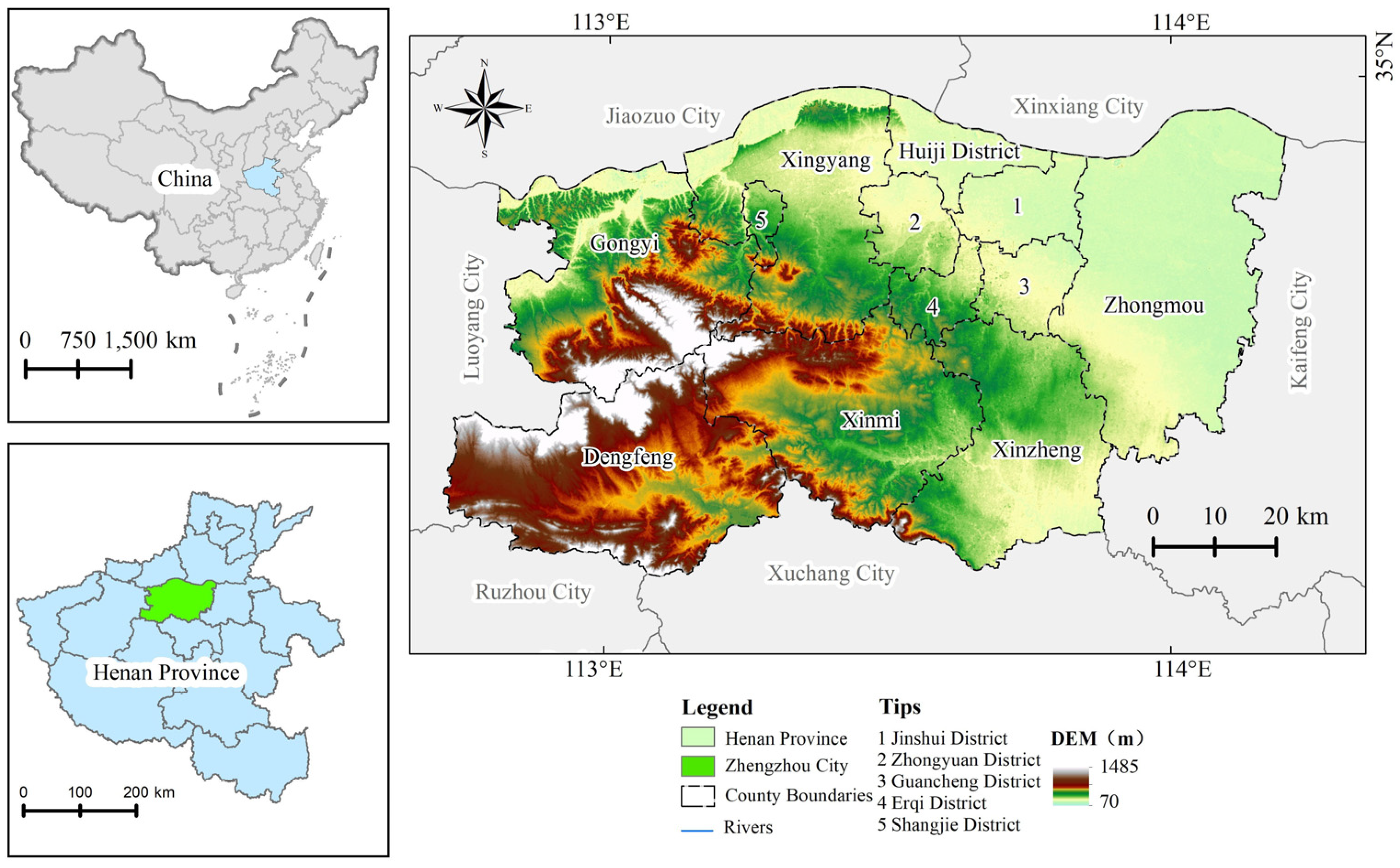
2.1. Study Area

Zhengzhou City (34°16’–34°58’ N, 112°42’–114°13’ E) is located south of the North China Plain, along the lower Yellow River, and is a city in the north part of Henan Province (Figure 1). The city is 166 km wide from east to west, 75 km long from north to south, borders the Yellow River in the north, the Song Mountain in the west, and the vast Huanghuai Plain in the southeast. The city spans across China’s second and third levels of terrain ladder, sloping down from southwest to northeast. It has a warm temperate continental monsoon climate with abundant solar and thermal resources. The actual mean annual sunshine hours are 2300 and the mean annual precipitation is 600–700 mm, most of which is concentrated in July, August, and September. With moderate rainfall, the city has water and heat conditions suitable for crop growth. It consists of various types of land cover, with cultivated land, forest land, and grassland accounting for 58%, 8%, and 5%, respectively. Zhengzhou is divided into six urban districts, one county, and five county-level cities. By the end of 2018, the city had a total area of 7446 km2, an urban area of 830.97 km2 with an urbanization rate of 72.2%, a total population of 10.136 million, and an annual GDP of 1014.33 billion yuan. The rapid urbanization has caused increasing pressure on the regional ecology.

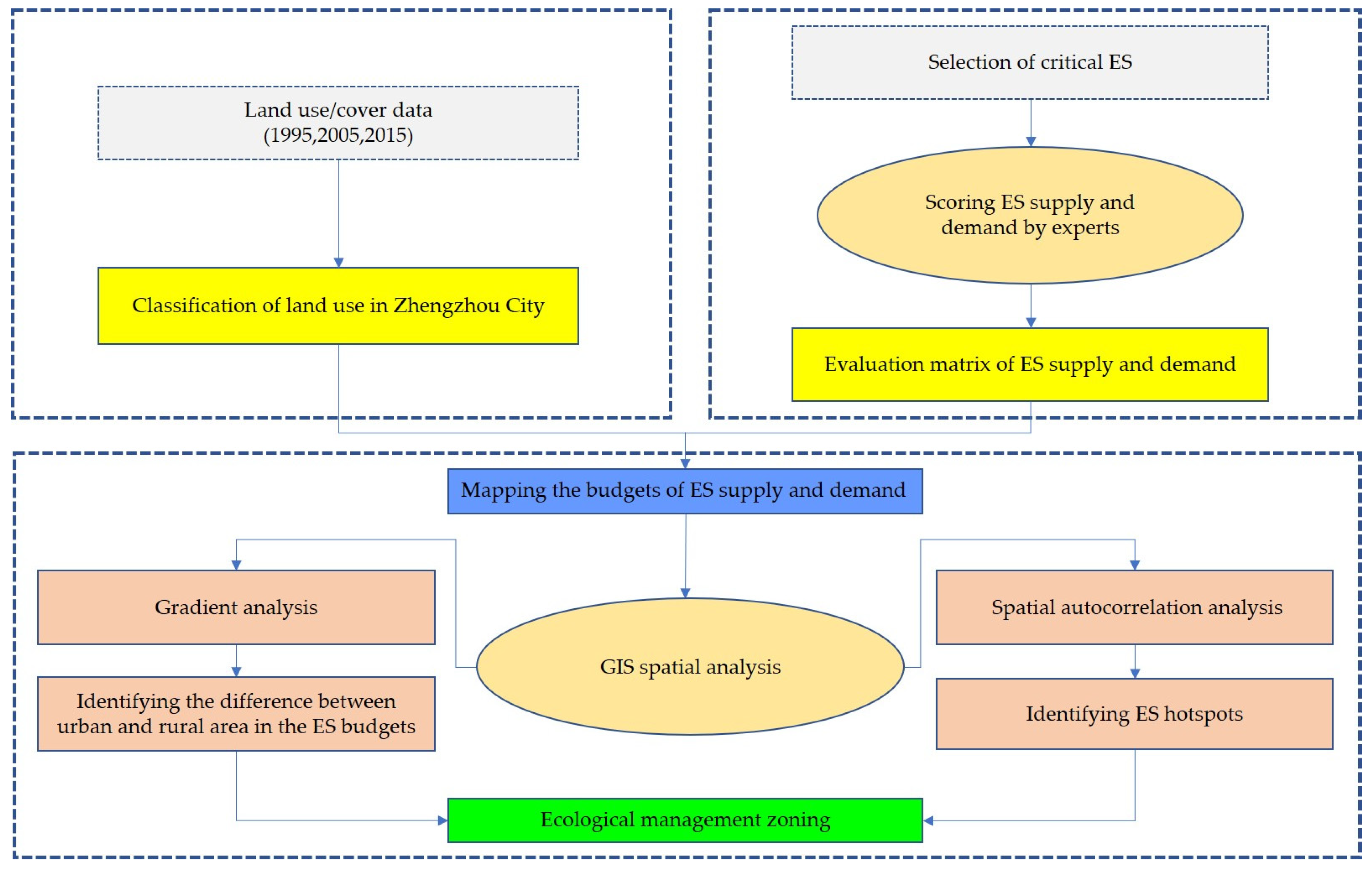
2.2. Research Framework

To achieve a sustainable ecological management regime in Zhengzhou City, we presented a comprehensive framework (Figure 2) for identifying dynamic changes of ES supply and demand and managing ES in the context of rapid urbanization. The framework can depict spatial and temporal characteristics of ES supply-and-demand budget to provide visual and effective information for ecosystem management and decision-making. First, considering the regional characteristics and local expert knowledge, we classified land use types in Zhengzhou into 15 types referring to the existing classification system. Second, scores of ES supply and demand in different land use types were obtained by an expert consultant and then evaluation matrixes of ES supply and demand were constructed. Third, an ES supply-and-demand budget index was created and mapped to reflect the spatial and temporal differences in the supply and demand of ES. Fourth, based on a GIS (geographic information system), gradient analysis and spatial autocorrelation analysis were employed to identify the urban–rural pattern and hotspots of ES budget. Finally, based on the spatial analysis results of ES supply-and-demand budget and local expert knowledge, ecological management zoning and policy implication was put forward to maintain the balance between ES supply and demand in rapidly urbanizing areas.

2.2.1. Classification of Land Use

The 1995, 2005, and 2015 phase 3 land use data of Zhengzhou used in this study were obtained from the National Land Use Data Set generated by the Data Center for Resources and Environmental Sciences, Chinese Academy of Sciences (RESDC) based on Landsat TM 30 m remote sensing image interpretation. The overall accuracy of land use classification was above 85% after field site verification, resident interviews, and verification through Google Earth high-resolution remote sensing images. In the original data, land use types were divided into 6 first-class and 22 second-class types based on the LUCC classification system in “China’s 20th Century Land Use/Cover Change (LUCC) Space–Time Platform”. Considering the regional characteristics and local expert knowledge, we integrated some land use types to make it practicable for Zhengzhou. In the processing, we referenced the CORINE (coordination of information on the environment in the EU) land classification method used by Burkhard et al. [4]. Although the CORINE focus on the European continent, it provides a good reference for land use classification of Zhengzhou city. Finally, we reclassified land use into 15 types in Zhengzhou, and Table 1 presents the land use types and the corresponding CORINE land use types.

2.2.2. Evaluation Matrix of Ecosystem Services Supply and Demand

Burkhard et al. [4] originally proposed the evaluation matrix of ES supply and demand in which experts assign values to geospatial units based on the ES supply capacity and human needs of different land use/cover types, thereby revealing the differences in the ability to provide ES by socio-ecosystems under LUCC [41]. Considering the ES classification of Millennium Ecosystem Assessment [42] and characteristics of Zhengzhou’s ecosystem, this paper divided ES into ecological integrity, provisioning services, regulating services, and cultural services. As ecological integrity serves as the basis and prerequisite of the other three services, which results in repeated calculation [4], it was removed from the ES study. Provisioning services consisted of six services, including crops, fodder, capture fisheries, timber, energy, and freshwater. Regulating services consisted of eight services including local climate regulation, flood protection, groundwater recharge, air quality regulation, erosion regulation, nutrient regulation, water purification, and pollination. Cultural services consisted of four services, including landscape aesthetics, recreation and eco-tourism, knowledge systems, and natural heritage. The score in the matrix table was set on a scale from 0 to 5, representing the supply and demand capacity of ES related to each land use type—0 stood for no relevant supply or demand of ES, 1 stood for low relevant supply or demand, 2 for relevant supply or demand, 3 for medium relevant supply or demand, 4 for high relevant supply or demand, and 5 for very high relevant supply or demand.
According to the matrix method proposed by Burkhard et al. [4], ecology experts were invited to rate the provisioning, regulating, and cultural services of land-use types in Zhengzhou. The specific steps were as follows:
(i) Consultation with experts. In June 2018, the team invited 16 experts with an ecological background and familiarity with the regional conditions of Zhengzhou, including 3 government agency staff members engaged in natural resource management, 3 experts from Henan University who were studying regional sustainable development, 3 experts from Henan Agricultural University who were conducting research on land ecology and soil science, 4 experts from Beijing Normal University who were engaged in ecological economy and ES evaluation, and another 3 experts from Henan Institute of Land and Resources Survey and Planning who were engaged in land reclamation and evaluation. To avoid misunderstanding, face-to-face interviews were conducted with the 16 experts who were informed in advance of the purpose of the interviews, the definition of ES supply and demand, the score scale of the ES supply and demand related to each land use type, and what each score stood for.
(ii) Obtaining scores of supply and demand of ES. Firstly, the team provided the matrix scoring tables of ES supply and demand in Zhengzhou to experts and each expert individually scored the supply and demand capabilities of different ES for each land use type. Secondly, the results of the first round of ES supply and demand matrix scored by the 16 experts were arithmetically averaged and rounded, and then returned to the experts for correction. After two rounds of iterations, expert consensus was obtained. Lastly, the ES supply and demand capacity values of Zhengzhou City were confirmed and the supply matrix (Table 2) and demand matrix (Table 3) obtained.

2.2.3. Mapping the Budgets of ES Supply and Demand

To reflect the spatial differences in the supply and demand of ES in Zhengzhou, a grid was used as an evaluation unit to measure it. Based on the land use data of Zhengzhou City, a 1 km × 1 km grid was selected as the basic evaluation unit [43]. Then, grid samples of budget indexes of ES supply and demand for different land use types were created. The budget indexes characterize the degree of balance between the ES supply and demand, and reveal the sustainability of regional ES [44]. According to the ES evaluation matrix (Table 2 and Table 3), and with reference to the work of Ou et al. [3], this study first built a grid-based total ES supply capacity and demand intensity model (Equation (1)) that included provisioning, regulating, and cultural services. Then, the difference between ES supply capacity and demand intensity was used to calculate the supply and demand index of ES for each grid.
E S ( E D ) = K = 1 L E K M K M i
E S D = E S E D
where ES stands for supply capacity of ES, ED is demand intensity for ES, Ek is supply capacity or demand intensity of ES for land use type k, Mk is the area of land use type k in the grid, Mi is the grid area, L is the number of land use types in the grid, and ESD is the budget index of ES supply and demand. According to the spatial distribution of the budget index of ES supply and demand in Zhengzhou, the natural breakpoint method was used to divide Zhengzhou into five categories, including severe deficit area, general deficit area, supply-and-demand balance area, general surplus area, and high surplus areas [45].

2.2.4. Gradient Analysis

Gradient analysis refers to the spatial feature analysis of landscape features that change gradually and regularly along a certain direction and the analysis can achieve the quantification and spatial visualization of local features [46,47]. Gradient analysis was employed to identify urban–rural patterns in the budgets of ES supply and demand, which can help decision-makers in land use management in striving for a sustainable balance between resource supply and demand. In order to improve visualization of the urban–rural gradients, the analysis was performed at the grid level and the values in the gradient belts were extracted from the map of ES supply-and-demand budget indexes. As the central urban district of Zhengzhou, Jinshui District is the political, economic, cultural, financial, and information center of Henan Province. Gongyi is an important node of the Zhengzhou–Luoyang industrial corridor and is home to a local industrial system with distinctive regional characteristics. Xinzheng, as the core component of Zhengzhou Airport Economy Zone, is a modern aviation economy-led industrial base. All these three areas are core growth poles of Zhengzhou, and show distinctive spatiotemporal characteristics of ES supply and demand. Therefore, with Jinshui District, Gongyi, and Xinmi as endpoints, this study formulated three urban development gradient belts with 1 km-wide grids—namely, Xinzheng–Jinshui belt (A, 48 km long), Gongyi–Xinzheng belt (B, 83 km long), and Jinshui–Gongyi belt (C, 65 km long) (Figure 3)—and analyzed the changes in the spatial features of the ES supply and demand in the three gradient belts at different times.

2.2.5. Spatial Autocorrelation Analysis

Spatial autocorrelation analysis (SAS) was employed to identify the hotspots of ES budgets. SAS mainly measures the correlation and spatial heterogeneity between geographic entities and includes global spatial and local spatial autocorrelation [12,48]. The former aims to test and determine the overall spatial distribution pattern, degree of correlation, and significance of the elements in the study area, whereas the latter is used to reflect the agglomeration and differentiation characteristics of local spatial units and their neighboring units to further discover local spatial instability [49]. According to the research objectives in this section, local SAS was employed to identify the hotspot areas of ES budget in Zhengzhou by using the cluster and outlier analysis tools in ArcGIS 10.2. First, according to the local autocorrelation of the ES budgets, the entire region was divided into five types, including high–high (HH) clustering type, high–low (HL) clustering, low–high (LH) clustering, low–low (LL) clustering, and nonsignificant (NS) correlation. Among these types, HH and LL clustering were positively correlated, indicating a high degree of spatial clustering of the ES budgets. LH and HL were negatively correlated, which indicates that the spatial structure of the ES budgets was highly discrete. NS indicated that the ES budgets showed no significant spatial clustering or discreteness [50]. Then, the study identified LL type as the hotspot area of ES supply and demand deficit. After the negative values were removed, the HH type was identified as the ES supply and demand surplus hotspot area, and the remaining types were identified as other areas.

3. Results

3.1. Land Use Change in Zhengzhou

Using the land use data of Zhengzhou in 1995, 2005, and 2015, the area and rate of land use change in the three periods was obtained (Table 4).
First, we found from the area changes in land use types that urban land, rural settlements, woodland, and high coverage grassland all increased. Among them, the increase in the rural settlements was the most obvious at 48,949.42 hm2. Dry land, sparse woodland, shrubbery, medium coverage grassland, and low coverage grassland all declined. The decrease in dry land was the most prominent, from 484,701.87 hm2 in 1995 to 419,108.51 hm2 in 2015, with a reduction of 65,593.36 hm2. Second, we found from the rate of land use change that the urban land in Zhengzhou increased the most significantly by 6.83% from 1995 to 2015. The dry land decreased the most, with a decrease of 8.81% from 1995 to 2015. The range of woodland and grassland (mainly medium and low coverage grassland) decreased in different degrees.
According to the land use map of Zhengzhou in the three periods (Figure 4), the increase of urban land and rural settlements area corresponded to the decrease of dry land, sparse woodland, shrubbery, and grassland areas, which is shown as the occupation of dry land, sparse woodland, shrubbery, and grassland by the expansion of urban land and rural settlements.

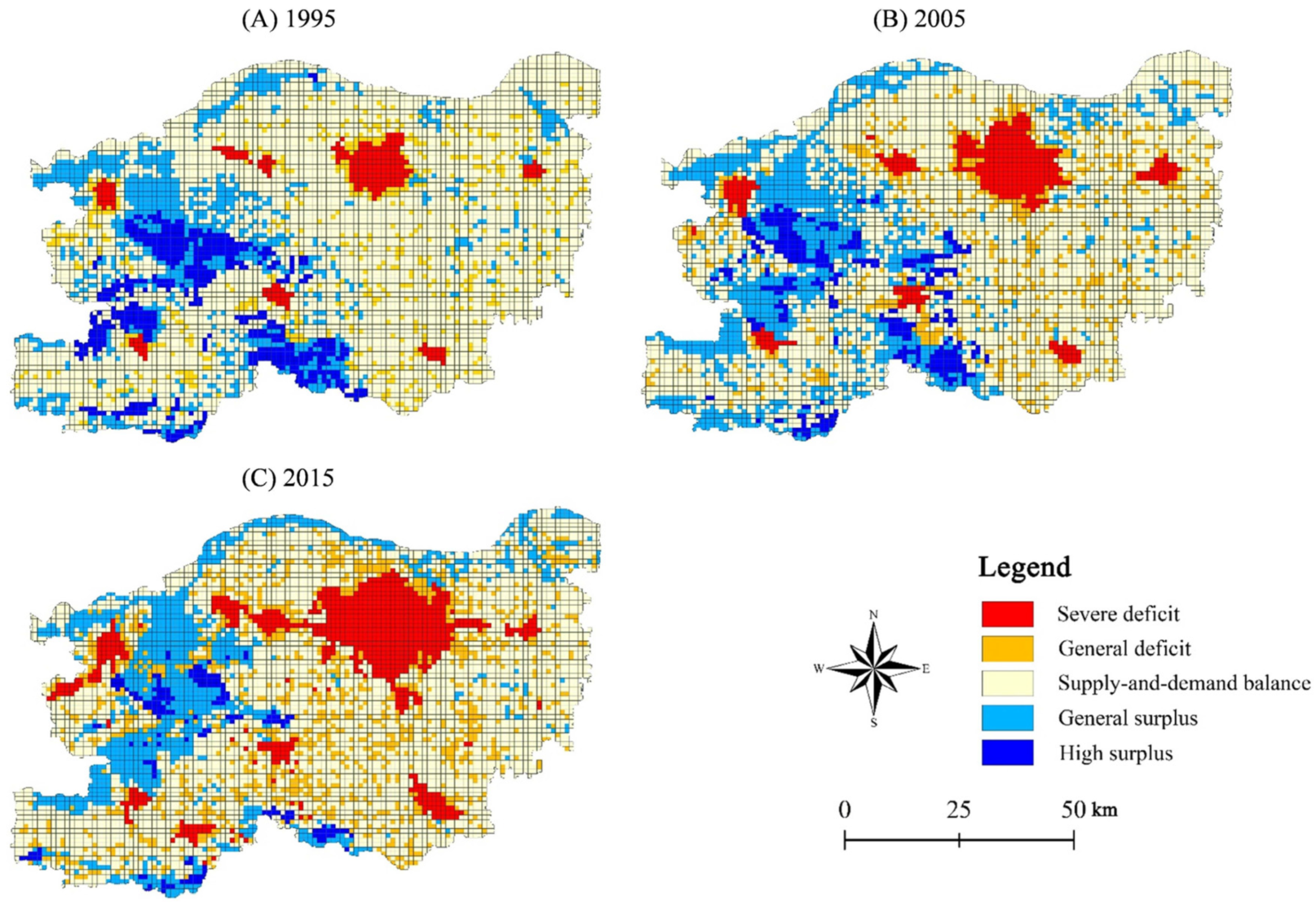
3.2. Spatiotemporal Evolution of ES Supply and Demand in Zhengzhou

The average budget index of Zhengzhou’s ES supply and demand decreased from 7.30 in 1995 to –4.89 in 2015. In general, Zhengzhou’s ES changed from supply exceeding demand to demand exceeding supply within 20 years. From 1995 to 2015, the regional differences in the budget of ES supply and demand in Zhengzhou showed overall surpluses in the west, near balance in the east, and deficits in the urban and county centers (Figure 5). Moreover, the spatial coverage of the deficit area continued to expand, the spatial scope of the surplus area continued to shrink, and the balance area decreased.
The area occupied by the severe deficits and the general deficit area continued to increase over the past 20 years. The severe deficit area grew from 3.34% in 1995 to 10.65% in 2015, with an increase of 3.19 times. The general deficit area grew by 8.15% from 8.01% in 1985 to 16.16% in 2015. Spatially, the severe deficit area was concentrated in the urban district of Zhengzhou, and continued to spread with the rapid expansion of urban boundaries. The general deficit area was distributed in a “circle layer” and “dot” shape. The “circle layer” was mostly concentrated around the urban area and was the transition zone between the supply-and-demand balance area and severe deficit area. The “dot” shape was scattered in the area of supply-and-demand balance, which is occupied by rural land. With the intensification of rural land use in recent years, the general deficit area in 2015 was connected by a number of scattered “dots” into a “slice”.
Over 20 years, Zhengzhou’s ES supply-and-demand balance area accounted for a high proportion of the total area, but as a whole it declined slightly from 67.61% in 1995 to 60.36% in 2015. Spatially, Zhengzhou’s supply-and-demand balance area was mainly distributed in dry land, paddy field, and surrounding areas.
Zhengzhou’s ES surplus areas shrank during the 20-year period. Among them, the high surplus area declined severely from 7.40% in 1995 to 2.35% in 2015, with a decrease of 3.15 times. The general surplus area decreased by 3.16%. Spatially, the high surplus area and general surplus area were concentrated in the ecological areas such as woodland, grassland, and water area in the west and south of Zhengzhou, such as Fuxi, Qinglong, and Shizu mountains.

3.3. Gradient Changes in ES Supply-and-Demand Budget in Zhengzhou

Overall, the ES supply-and-demand budget index in the three gradient belts declined over the past 20 years, and most regions in the gradient belts had the lowest supply-and-demand budget indexes in 2015 (Figure 6). The Xinzheng–Jinshui gradient belt was relatively stable, and the ES supply and demand were mainly balanced or near-balanced (Figure 6A). Jinshui District is in the core area of Zhengzhou, and its ES supply-and-demand budget index is in a low-value area, which is mainly in a deficit state.
The Gongyi–Xinzheng belt passed through Gongyi, Xingyang, Xinmi, and Xinzheng (Figure 6B). The ES supply and demand in eastern Gongyi and southern Xingyang was mainly a surplus. The rural land in Xinmi was distributed extensively, and ES supply-and-demand budget index fluctuated greatly in this region.
The Jinshui–Gongyi belt passed through the core area of Zhengzhou, Xingyang, and Gongyi (Figure 6C). The gradient belt showed a clear inverted U-shaped distribution. In the Jinshui and the main urban area of Xingyang, the ES supply and demand exhibited mainly a deficit. The situation was improved after the entrance to Gongyi, but a deficit was observed after entrance to the main urban area.
To sum up, urban–rural gradient differences exist in the budgets of ES supply and demand in Zhengzhou. Core development areas such as the Zhengzhou urban areas were in deficit, and the ES supply and demand in rural areas far from the city center showed a surplus or balance.

3.4. Hotspots of ES Supply-and-Demand Budget in Zhengzhou

Using the spatial analysis tools of ArcGIS 10.2, the clustering characteristics of the ES supply and demand over a three-year period were analyzed to obtain the surplus and deficit hotspots of ES budget in Zhengzhou (Figure 7). The partial Moran’s I indexes for the three years were all positive, suggesting that the ES supply-and-demand budget index in Zhengzhou showed a significant positive spatial autocorrelation. The ratio of Zhengzhou’s ES supply deficit hotspot area increased from 7.52% in 1985 to 13.29% in 2015, with an overall increase of 5.77%. The surplus hotspot area accounted for 6.37%, 3.91%, and 2.33% in the three years, with a reduction of 2.73 times in 20 years.
The deficit hotspots of ES budgets were in a multicore distribution pattern. From 1995 to 2015, the deficit hotspots of ES budgets continued to expand around each built–up area in Zhengzhou, which responded to the rapid development of urbanization. In 2015, a corridor was observed in the deficit hotspot area among the Zhengzhou core area, Zhongmou, and Xingyang. In 1995, the surplus hotspot areas were concentrated in the mountainous areas in the west and south of Zhengzhou, but they continued to disperse over time, and the scope continued to shrink. By 2015, these areas were mainly distributed as clusters.

4. Discussion

4.1. Matrix Method

Burkhard et al. [4] proposed a matrix model for quantifying the ES supply and demand based on LUCC. This method can quickly integrate a variety of data in space, and is suitable for study at various scales, especially for the areas with poor data [51,52]. This method can easily identify the spatiotemporal changes in the supply and demand of regional ES and has been successfully applied to study the ES supply and demand in many regions [13,25,26,27,29,30,31]. Rapid urbanization has greatly changed the land use/land cover situation in Zhengzhou, leading to reductions in the nature ecosystems (e.g., forest and grass), which has threatened the carrying status of ES. Thus, identifying the key areas of the contradiction between the ES supply and demand is crucial. A rational task is to select the suitable evaluation matrix method to evaluate the ES supply and demand in Zhengzhou. Products and services provided by natural ecosystems to humans have different units of measurement. For example, the unit of measure for crop is t and that for groundwater is m3. Moreover, quantifying such ES as a knowledge system and natural heritage is difficult. These issues have led to difficulty in regional data integration and calculation. As a dimensionless evaluation method, the evaluation matrix of ES supply and demand can prevent the problem of regional parameter integration [53,54,55], quickly evaluate the situation of Zhengzhou’s ES supply and demand in space, and conduct a comparative study of temporal dynamics.
However, the ES supply and demand evaluation matrix is limited by the subjective experience, knowledge, and attitude of the interviewed experts [56,57,58]. Therefore, iterating the expert evaluation results during the evaluation process can be conducted in several ways to improve the accuracy of the evaluation. In this study, before the expert evaluation, the differences between the different scores of the supply and demand matrices was indicated in detail. The Delphi method was used to concentrate, summarize, count, and provide feedback for the expert evaluation results, which were iterated enough times until a consensus was reached. Thus, the errors caused by the randomness of expert subjective judgment can be reduced. The ES supply and demand matrix involves uncertainties in the evaluation process, such as in the fields of natural ecosystem supply, preferences, and technical factors [59]. The uncertainty of natural ecosystem supply is due to the lack of ecosystem cognition. The uncertainty of preference is a result of the experience differences in the ES supply and the human demands. The uncertainty of technology arises from the differences in data type, index quantification, and charting methods. The 16 experts selected in this study had an ecological knowledge background and were highly familiar with Zhengzhou and its ecosystems, which reduced the natural ecosystem supply uncertainty of the supply–demand matrix score. The results of the expert evaluation were iterated several times, thereby reducing the preferences uncertainty of the ES supply and demand matrix score. On the data source of the study, the national land use data set generated from Landsat TM 30 m remote sensing image interpretation was verified by field site selection and Google Earth high-resolution remote sensing images. The technical uncertainty of the evaluation results was reduced by optimizing the data quality. Furthermore, the grid-based research can suggest the spatial heterogeneity of the ES supply and demand [43], thereby preventing the information loss of spatial continuity caused by the division of administrative units.

4.2. Factors Affecting ES Supply and Demand

This study analyzed the dynamic characteristics of the ES supply and demand in Zhengzhou from three aspects, including spatiotemporal evolution of the supply and demand, gradient changes, and hotspots. The results are consistent with the existing research [3,4,45]. Spatially, the deficit areas of ES budgets were highly consistent with the distribution of urban and rural land. The surplus areas of ES budgets were mostly concentrated in the ecological areas with low intensity of human activities and high vegetation coverage. The areas with a balance between ES supply and demand were mainly distributed in dry land, paddy fields, and surrounding areas. The budget of ES supply and demand was closely related to the type of land use. The changes in land use types affected the ES supply-and-demand budget by altering the structure and functions of ecosystems [42]. Changes in supply and demand of ES and changes in land use also responded to each other [60,61], but changes in the ES supply and demand had different sensitivities to different land use types. The differences in ES capacities among the different land use types were the main causes of the sensitivity variation.
In recent years, with the implementation of the growth strategy for central China and the development of the Central Plains Economic Zone, the urbanization and industrialization process has been speeding up in Zhengzhou. Construction land is encroaching on the farmland, water, and woodland around the core area of Zhengzhou. The regional ecological overload is prominent, which has caused an imbalance between the supply and demand of ES. From 1995 to 2015, all the woodland and grassland areas in Zhengzhou decreased by 283.61 km2 and 137.11 km2, respectively, and the urban land expanded by 217.21 km2. At the same time, rapid population growth and economic development were driving increased demand for ES. The total population of Zhengzhou grew from 6.003 million in 1995 to 9.569 million in 2015. The gross domestic product of Zhengzhou increased from 38.64 billion yuan in 1995 to 731.15 billion yuan in 2015. Therefore, the relationship between the supply and demand of ES has shown an evolutionary trend of demand exceeding supply. Government policy guidance, such as urban spatial layout planning, also affects the ES supply and demand. In the process of urban spatial layout, Zhengzhou is guided by the concept of “one center and four cities,” that is, the center is built–up areas of Zhengzhou, and the peripheral cities are Gongyi, Xinzheng, Xinmi, and Dengfeng, which form the core area of urban development. Therefore, in terms of the urban–rural spatial gradient, Zhengzhou’s ES supply-and-demand budget indexes had significant differences. The supply-and-demand budget changes in most regions close to the core area of urban development were dramatic, and the deficit status continued to increase. The status of ES supply and demand in rural areas was relatively stable. In addition, influenced by the policy of “Zhengzhou and Kaifeng integration” (urban core area developing to the east) and “Zhengxi New City” (urban core area developing to the west), a “corridor” was formed between the deficit hotspot area among the Zhengzhou core area, Zhongmou, and Xingyang.

4.3. Ecological Management Zoning and Policy Implications

Zhengzhou has been identified as the core city of the Central Henan Urban Agglomeration and national central city. With the rapid economic development, the continuous expansion of urbanization, and the increasing population growth, Zhengzhou is expected to face more prominent problems in the future. To achieve a sustainable ecological management regime in Zhengzhou City, applicable ecological management zoning is necessary. Based on the spatial analysis results of the ES supply-and-demand budgets in different periods and local expert knowledge, towns of Zhengzhou city were divided three ecological management zones: ecological conservation area, ecological improvement area, and ecological reconstruction area (Figure 8). We used the administrative boundary to make the zoning friendly to the local government. The ecological conservation area included 18 towns and the area proportion was 18.58%. Most towns in the ecological conservation area were ES surplus hotspots and mainly distributed in Gongyi and Xinmi. The ecological improvement area included 60 towns and the area proportion was 58.13%. Most towns in the ecological improvement area showed ES supply-and-demand balance and had an extensive distribution in Zhengzhou. The ecological reconstruction area included 23 towns and the area proportion was 23.29%. Most towns in the ecological reconstruction area were ES deficit hotspots and mainly distributed in the core development area of Zhengzhou. Studies have shown that the sustainable development could be achieved by effective ES management strategies [45]. According to the results of ecological management zoning and ES supply-and-demand characteristics, differentiated management measures should be implemented.
Ecological conservation areas, which are dominated by woodland, grassland, and other natural land, are an important source of ES supply and should be strictly protected. In this zone, the ecological endowment and biodiversity is good, but it can be damaged easily because of its strong ecological sensitivity. Thus, strict control to human activities is necessary and large-scale construction should be prohibited. In the surplus areas, including Fuxi, Qinglong, and Shizu mountains of western and southern Zhengzhou, the ecological protection red line should be delineated. The local government should strictly control the population agglomeration and urban expansion, optimize the structure of land use, and strengthen ecological forestry construction. Moreover, damaged and destroyed ecological areas should be restored to maintain the integrity of their natural ecosystems based on the ecological characteristics of the land.
Ecological improvement areas, which are dominated by paddy fields and dry land, are the borderline area of ES supply and demand, and can be easily disturbed by human activities, thereby turning into a deficit area (ecological reconstruction area). The ecological improvement zone in Zhengzhou is the largest and should be given special attention. These areas should implement the policy of the basic cultivated land protection line and restrict or prohibit the occupation of cultivated land in the area by other land use types (especially urban land). Zhengzhou needs to stabilize agricultural production functions and further develop the role of agricultural regulating and cultural services supply (e.g., agricultural tourism and leisure services) through land consolidation, agricultural scale operation, and beautiful village construction. Moreover, agricultural structure should be adjusted to improve ES benefits, especially in key areas such as the ecological agricultural areas along the Yellow River. The local government should organize professional institutions to regularly monitor and evaluate the quality of cultivated land and improve the monitoring system to achieve the protection of cultivated land. Cultivated land, river channels, shelter forests. and roads should be comprehensively improved to enhance ES supply and promote the transition from a balance area to a surplus area of ES budgets.
Overall ecological renovation and targeted ecological reconstruction should be carried out in the ecological reconstruction areas, which are mainly urban land. This zone has rapid urbanization, little vegetation, and simple ecological structure. The governments should consider the improvement of ecological benefits in the process of rapid urbanization. The spatial planning in Zhengzhou should be compiled to control the growth boundaries strictly, especially the core development areas, such as the growth boundaries of the Zhengzhou East District and Xinzheng Airport District. In addition, in the area mainly used for construction land, attention should be paid to the improvement of urban green coverage. By embedding green patches and green corridors into urban landscape, the core development area of Zhengzhou can construct an urban ecologic green space system to achieve the coordinated development of economic and ecology.

4.4. Limitations and Contributions of the Research

Our study applied an effective framework for assessing dynamic changes in ES supply and demand and informed ecological management zoning strategies. However, there are still some limitations in our study. Firstly, the ES matrix method cannot capture spatial heterogeneity of ES capacities within the same land-use type. Areas within the same land-use type may have different capacities to supply ES. For example, it is likely that the services provided by artificial grassland are much lower than those by natural grassland. An ecosystem quality grade map can improve the scoring accuracy of ES capacities, but it is difficult to get the data from the rapid urbanization areas. Secondly, the ES matrix method only helped to define the potential but not actual scores of ES. Biophysical or consumption processes weren’t taken into account. ES are delivered across boundaries in nature, but our analysis was confined within the municipal boundary. However, Zhengzhou’s ES supply-and-demand budget index developed in our study still reflects the load of the human demand on ecological resources carried by the ecosystem, so the actual problem solved by the ES matrix is the carrying status of the ES.
Despite the limitations, our framework is still suitable for ecological management, especially in data-scare regions. Our results demonstrate that the indexes are capable of satisfactorily depicting the carrying capacity of ecosystems and township–based ecological management zoning in Zhengzhou can provide visual information for decision makers. There are some other contributions. Iterating innovatively the expert evaluation results during the evaluation process can improve the accuracy of the evaluation, which reduces the uncertainties of ES scoring in some degree. In addition, as a typical city in central China in the context of rapid urbanization, Zhengzhou has some reference value for other cities in central China. Our paper enriches ES research in central China. For other data-scarce and rapidly urbanized areas in central China, the evaluation matrix of ES supply and demand can quickly evaluate the status of ES supply and demand in specific spaces, and conduct a comparative study of temporal dynamics, which will be a great help for decision makers to quickly identify crucial spatial points and effectively decide protection priority areas.

5. Conclusions

Using land use data of Zhengzhou City in 1995, 2005, and 2015 and incorporating expert knowledge and the ES evaluation matrix, this study evaluated the spatial and temporal changes in the ES supply and demand in Zhengzhou over the past 20 years. Gradient analysis was conducted to identify urban–rural gradient changes in the budgets of ES supply and demand. Spatial autocorrelation analyses were employed to identify the hotspot areas of ES budgets. The research results show the following: (1) In the past 20 years, Zhengzhou has seen a decrease in ES supply and an increase in demand, and the relationship between supply and demand has gradually evolved in a direction where supply falls short of demand. The area covered by ES deficit increased from 11.35% in 1995 to 26.81% in 2015, and the area covered by ES surplus decreased from 21.04% in 1985 to 12.83% in 2015. Changes in the supply and demand status of ES in Zhengzhou corresponded to the background of rapid urbanization. (2) Urban–rural gradient differences exist in the budgets of ES supply and demand in Zhengzhou. Core development areas, such as the Zhengzhou urban areas, are in deficit, whereas a balance or surplus can be observed in rural areas far from urban centers. (3) The surplus hotspots of ES budgets were mainly distributed in the western and southern mountainous areas of Zhengzhou, and they were scattered and the scope shrank, with a decrease of 2.73 times in 20 years, whereas the deficit hotspots expanded outward with each urban area as the center, with an increase of 5.77%. Ecological management zoning (ecological conservation area, ecological improvement area, and ecological reconstruction area) with the effective guidance of ecological and economic policies can comprehensively improve ES management and achieve urban sustainability. The framework, which incorporates the ES supply and demand evaluation matrix, can easily and quickly assess the supply and demand status of ES and provide scientific support for the management of these services in rapidly urbanizing areas.

Author Contributions

H.W. and Z.J. designed the paper. Z.J. and H.W. collected the data and wrote the paper. Y.X. assumed advisory roles. All authors have read and approved the final manuscript.

Funding

This research was funded by the science and technology innovation foundation of Henan Agricultural University (grant number KJCX2019B05), the special fund for top talents in Henan Agricultural University (grant number 30500425), National Natural Science Foundation of China (grant number 41901259).

Conflicts of Interest

The authors declare no conflict of interest.

References

  1. de Groot, R.S.; Alkemade, R.; Braat, L.; Hein, L.; Willemen, L. Challenges in integrating the concept of ecosystem services and values in landscape planning, management and decision making. Ecol. Complex. 2010, 7, 260–272. [Google Scholar] [CrossRef]
  2. Wei, H.; Liu, H.; Xu, Z.; Ren, J.; Lu, N.; Fan, W.; Zhang, P.; Dong, X. Linking ecosystem services supply, social demand and human well-being in a typical mountain-oasis-desert area, Xinjiang, China. Ecosyst. Serv. 2018, 31, 44–57. [Google Scholar] [CrossRef]
  3. Ou, W.; Wang, H.; Tao, Y. A land cover-based assessment of ecosystem services supply and demand dynamics in the Yangtze River Delta region. Acta Ecol. Sin. 2018, 38, 6337–6347. (In Chinese) [Google Scholar]
  4. Burkhard, B.; Kroll, F.; Nedkov, S.; Müller, F. Mapping ecosystem service supply, demand and budgets. Ecol. Indic. 2012, 21, 17–29. [Google Scholar] [CrossRef]
  5. Yan, Y.; Zhu, J.; Wu, G.; Zhan, Y. Review and prospective applications of demand, supply, and consumption of ecosystem services. Acta Ecol. Sin. 2017, 37, 2489–2496. (In Chinese) [Google Scholar]
  6. Kumar, P. The Economics of Ecosystems and Biodiversity: Ecological and Economic Foundations; Routledge: London, UK, 2012. [Google Scholar]
  7. Geijzendorffer, I.R.; Martín-López, B.; Roche, P.K. Improving the identification of mismatches in ecosystem services assessments. Ecol. Indic. 2015, 52, 320–331. [Google Scholar] [CrossRef]
  8. Ma, C.; Wang, X.; Zhang, Y.; Li, S. Emergy analysis of ecosystem services supply and flow in Beijing ecological conservation area. Acta Geogr. Sin. 2017, 72, 974–985. (In Chinese) [Google Scholar]
  9. Roces-Díaz, J.V.; Vayreda, J.; Banqué-Casanovas, M.; Díaz-Varela, E.; Bonet, J.A.; Brotons, L.; De-Miguel, S.; Herrando, S.; Martínez-Vilalta, J. The spatial level of analysis affects the patterns of forest ecosystem services supply and their relationships. Sci. Total Environ. 2018, 626, 1270–1283. [Google Scholar] [CrossRef] [Green Version]
  10. Wang, Q.; Li, G. The evaluation of the watershed ecological compensation standard of ecosystem service value: A case of Weihe watershed upstream. Acta Ecol. Sin. 2019, 39, 108–116. (In Chinese) [Google Scholar]
  11. Xie, G. Biodiversity and ecosystem services in city. Environ. Prot. 2015, 43, 25–28. (In Chinese) [Google Scholar]
  12. Baró, F.; Palomo, I.; Zulian, G.; Vizcaino, P.; Haase, D.; Gómez-Baggethun, E. Mapping ecosystem service capacity, flow and demand for landscape and urban planning: A case study in the Barcelona metropolitan region. Land Use Policy 2016, 57, 405–417. [Google Scholar] [CrossRef] [Green Version]
  13. Li, S.; Wang, Y.; Zhu, W.; Zhang, J.; Gao, Y.; Wang, Y.; Li, Y. Research framework of ecosystem services geography from spatial and regional perspectives. Acta Geogr. Sin. 2014, 69, 1628–1639. (In Chinese) [Google Scholar]
  14. Termansen, M.; McClean, C.J.; Jensen, F.S. Modelling and mapping spatial heterogeneity in forest recreation services. Ecol. Econ. 2013, 92, 48–57. [Google Scholar] [CrossRef]
  15. Shao, H.; Liu, M.; Shao, Q.; Sun, X.; Wu, J.; Xiang, Z.; Yang, W. Research on eco-environmental vulnerability evaluation of the Anning River Basin in the upper reaches of the Yangtze River. Environ. Earth Sci. 2014, 72, 1555–1568. [Google Scholar] [CrossRef]
  16. Tolessa, T.; Senbeta, F.; Kidane, M. The impact of land use/land cover change on ecosystem services in the central highlands of Ethiopia. Ecosyst. Serv. 2017, 23, 47–54. [Google Scholar] [CrossRef]
  17. Wei, H.; Fan, W.; Lu, N.; Xu, Z.; Liu, H.; Chen, W.; Ulgiati, S.; Wang, X.; Dong, X. Integrating Biophysical and Sociocultural Methods for Identifying the Relationships between Ecosystem Services and Land Use Change: Insights from an Oasis Area. Sustainability 2019, 11, 2598. [Google Scholar] [CrossRef] [Green Version]
  18. Wei, H.; Fan, W.; Wang, X.; Lu, N.; Dong, X.; Zhao, Y.; Ya, X.; Zhao, Y. Integrating supply and social demand in ecosystem services assessment: A review. Ecosyst. Serv. 2017, 25, 15–27. [Google Scholar] [CrossRef]
  19. Li, J.; Jiang, H.; Bai, Y.; Alatalo, J.M.; Li, X.; Jiang, H.; Liu, G.; Xu, J. Indicators for spatial-temporal comparisons of ecosystem service status between regions: A case study of the Taihu River Basin, China. Ecol. Indic. 2016, 60, 1008–1016. [Google Scholar] [CrossRef]
  20. Zhang, W.; Wu, X.; Yu, Y.; Cao, J. The changes of ecosystem services supply-demand and responses to rocky desertification in Xiaojiang Basin during 2005–2015. J. Soil Water Conserv. 2019, 33, 139–150. (In Chinese) [Google Scholar]
  21. Nedkov, S.; Burkhard, B. Flood regulating ecosystem services—Mapping supply and demand, in the Etropole municipality, Bulgaria. Ecol. Indic. 2012, 21, 67–79. [Google Scholar] [CrossRef]
  22. Palacios-Agundez, I.; Onaindia, M.; Barraqueta, P.; Madariaga, I. Provisioning ecosystem services supply and demand: The role of landscape management to reinforce supply and promote synergies with other ecosystem services. Land Use Policy 2015, 47, 145–155. [Google Scholar] [CrossRef]
  23. Peña, L.; Casado-Arzuaga, I.; Onaindia, M. Mapping recreation supply and demand using an ecological and a social evaluation approach. Ecosyst. Serv. 2015, 13, 108–118. [Google Scholar] [CrossRef]
  24. Scolozzi, R.; Morri, E.; Santolini, R. Delphi-based change assessment in ecosystem service values to support strategic spatial planning in Italian landscapes. Ecol. Indic. 2012, 21, 134–144. [Google Scholar] [CrossRef]
  25. Bicking, S.; Burkhard, B.; Kruse, M.; Müller, F. Mapping of nutrient regulating ecosystem service supply and demand on different scales in Schleswig-Holstein, Germany. One Ecosyst. 2018, 3, e22509. [Google Scholar] [CrossRef] [Green Version]
  26. Schirpke, U.; Candiago, S.; Egarter Vigl, L.; Jäger, H.; Labadini, A.; Marsoner, T.; Meisch, C.; Tasser, E.; Tappeiner, U. Integrating supply, flow and demand to enhance the understanding of interactions among multiple ecosystem services. Sci. Total Environ. 2019, 651, 928–941. [Google Scholar] [CrossRef] [PubMed]
  27. Burkhard, B.; Müller, A.; Müller, F.; Grescho, V.; Anh, Q.; Arida, G.; Bustamante, J.V.J.; Van Chien, H.; Heong, K.L.; Escalada, M. Land cover-based ecosystem service assessment of irrigated rice cropping systems in southeast Asia—An explorative study. Ecosyst. Serv. 2015, 14, 76–87. [Google Scholar] [CrossRef]
  28. Boithias, L.; Acuña, V.; Vergoñós, L.; Ziv, G.; Marcé, R.; Sabater, S. Assessment of the water supply: Demand ratios in a Mediterranean basin under different global change scenarios and mitigation alternatives. Sci. Total Environ. 2014, 470–471, 567–577. [Google Scholar] [CrossRef]
  29. Wu, A.; Zhao, Y.; Shen, H.; Qin, Y.; Liu, X. Spatio-temporal pattern evolution of ecosystem service supply and demand in Beijing-Tianjin-Hebei region. J. Ecol. Rural Environ. 2018, 34, 968–975. (In Chinese) [Google Scholar]
  30. Shi, Y.; Shi, D. Study on the balance of ecological service supply and demand in Dongting Lake ecological economic zone. Geogr. Res. 2018, 37, 1714–1723. (In Chinese) [Google Scholar]
  31. He, S.; Su, Y.; Shahtahmassebi, A.R.; Huang, L.; Zhou, M.; Gan, M.; Deng, J.; Zhao, G.; Wang, K. Assessing and mapping cultural ecosystem services supply, demand and flow of farmlands in the Hangzhou metropolitan area, China. Sci. Total Environ. 2019, 692, 756–768. [Google Scholar] [CrossRef]
  32. Stoll, S.; Frenzel, M.; Burkhard, B.; Adamescu, M.; Augustaitis, A.; Baeßler, C.; Bonet, F.J.; Carranza, M.L.; Cazacu, C.; Cosor, G.L. Assessment of ecosystem integrity and service gradients across Europe using the LTER Europe network. Ecol. Model. 2015, 295, 75–87. [Google Scholar] [CrossRef]
  33. Jacobs, S.; Burkhard, B.; Van Daele, T.; Staes, J.; Schneiders, A. ‘The Matrix Reloaded’: A review of expert knowledge use for mapping ecosystem services. Ecol. Model. 2015, 295, 21–30. [Google Scholar] [CrossRef]
  34. Goldenberg, R.; Kalantari, Z.; Cvetkovic, V.; Mörtberg, U.; Deal, B.; Destouni, G. Distinction, quantification and mapping of potential and realized supply-demand of flow-dependent ecosystem services. Sci. Total Environ. 2017, 593–594, 599–609. [Google Scholar] [CrossRef] [PubMed]
  35. Cai, W.; Gibbs, D.; Zhang, L.; Ferrier, G.; Cai, Y. Identifying hotspots and management of critical ecosystem services in rapidly urbanizing Yangtze River Delta Region, China. J. Environ. Manag. 2017, 191, 258–267. [Google Scholar] [CrossRef]
  36. Tao, Y.; Wang, H.; Ou, W.; Guo, J. A land-cover-based approach to assessing ecosystem services supply and demand dynamics in the rapidly urbanizing Yangtze River Delta region. Land Use Policy 2018, 72, 250–258. [Google Scholar] [CrossRef]
  37. Campagne, C.; Roche, P.; Gosselin, F.; Tschanz, L.; Tatoni, T. Expert-based ecosystem services capacity matrices: Dealing with scoring variability. Ecol. Indic. 2017, 79, 63–72. [Google Scholar] [CrossRef] [Green Version]
  38. Zurqani, H.; Post, C.; Mikhailova, E.; Allen, J. Mapping urbanization trends in a forested landscape using google earth engine. Remote Sens. Earth Syst. Sci. 2019, 2, 173–182. [Google Scholar] [CrossRef]
  39. Wu, K.; Fang, C.; Huang, H.; Wang, J. Comprehensive delimitation and ring identification on urban spatial radiation of regional central cities: Case study of Zhengzhou. J. Urban Plan. Dev. 2013, 139, 258–273. [Google Scholar] [CrossRef]
  40. Mu, B.; Mayer, A.L.; He, R.; Tian, G. Land use dynamics and policy implications in Central China: A case study of Zhengzhou. Cities 2016, 58, 39–49. [Google Scholar] [CrossRef]
  41. Li, T.; Lu, Y. A review on the progress of modeling techniques in ecosystem services. Acta Ecol. Sin. 2018, 38, 5287–5296. (In Chinese) [Google Scholar]
  42. Millennium Ecosystem Assessment (MA). Ecosystem and Human Wellbeing: Current State and Trends; Island Press: Washington, DC, USA, 2005. [Google Scholar]
  43. Chen, J.; Zhang, Y.; Yu, Y. Effect of MAUP in spatial autocorrelation. Acta Geogr. Sin. 2011, 66, 1597–1606. [Google Scholar]
  44. Chen, J.; Jiang, B.; Bai, Y.; Xu, X.; Alatalo, J.M. Quantifying ecosystem services supply and demand shortfalls and mismatches for management optimisation. Sci. Total Environ. 2019, 650, 1426–1439. [Google Scholar] [CrossRef] [PubMed]
  45. Guan, Q.; Hao, J.; Xu, Y.; Ren, G.; Kang, L. Zoning of agroecological management based on the relationship between supply and demand of ecosystem services. Resour. Sci. 2019, 41, 1359–1373. (In Chinese) [Google Scholar]
  46. Li, Q.; Li, T.; Yang, M.; Ying, W. Spatiotemporal variation of ecosystem services value based on gradient analysis in Wuhan: 2000–2010. Acta Ecol. Sin. 2017, 37, 2118–2125. (In Chinese) [Google Scholar]
  47. Radford, K.G.; James, P. Changes in the value of ecosystem services along a rural-urban gradient: A case study of Greater Manchester, UK. Landsc. Urban Plan. 2013, 109, 117–127. [Google Scholar] [CrossRef]
  48. Lei, J.; Chen, Z.; Wu, T.; Li, L.; Yang, Q.; Chen, X. Spatial autocorrelation pattern analysis of land use and the value of ecosystem services in northeast Hainan island. Acta Ecol. Sin. 2015, 39, 2366–2377. (In Chinese) [Google Scholar]
  49. Chen, S.; Sleipness, O.R.; Christensen, K.M.; Feldon, D.; Xu, Y. Environmental justice and park quality in an intermountain west gateway community: Assessing the spatial autocorrelation. Landsc. Ecol. 2019, 34, 2323–2335. [Google Scholar] [CrossRef]
  50. Zhao, X.; Zhou, W.; Han, L.; Locke, D. Spatiotemporal variation in PM2.5 concentrations and their relationship with socioeconomic factors in China’s major cities. Environ. Int. 2019, 133, 105145. [Google Scholar] [CrossRef]
  51. Burkhard, B.; Kandziora, M.; Hou, Y. Ecosystem service potentials, flows and demands-concepts for spatial localisation, indication and quantification. Landsc. Online 2014, 34, 1–32. [Google Scholar] [CrossRef]
  52. Bai, Y.; Wang, M.; Li, H.; Huang, S.; Juha, M.A. Ecosystem service supply and demand: Theory and management application. Acta Ecol. Sin. 2017, 37, 5846–5852. (In Chinese) [Google Scholar]
  53. Kienast, F.; Bolliger, J.; Potschin, M.; de Groot, R.S.; Verburg, P.H.; Heller, I.; Wascher, D.; Haines-Young, R. Assessing landscape functions with broad-scale environmental data: Insights gained from a prototype development for Europe. Environ. Manag. 2009, 44, 1099–1120. [Google Scholar] [CrossRef] [Green Version]
  54. Haines-Young, R.; Potschin, M.; Kienast, F. Indicators of ecosystem service potential at European scales: Mapping marginal changes and trade-offs. Ecol. Indic. 2012, 21, 39–53. [Google Scholar] [CrossRef]
  55. Liu, s.; Yang, Y.; Wang, Y. Mapping supply and demand differentiation of hydrological regulation service based on matrix analysis: A case study of Jiaxing City, Zhejiang Province. Acta Ecol. Sin. 2019, 39, 1189–1202. (In Chinese) [Google Scholar]
  56. Sun, J.; Liu, L.; Müller, K.; Zander, P.; Ren, G.; Yin, G.; Hu, Y. Surplus or Deficit? Spatiotemporal Variations of the Supply, Demand, and Budget of Landscape Services and Landscape Multifunctionality in Suburban Shanghai, China. Sustainability 2018, 10, 3752. [Google Scholar] [CrossRef] [Green Version]
  57. Kaiser, G.; Burkhard, B.; Römer, H.; Sangkaew, S.; Graterol, R.; Haitook, T.; Sterr, H.; Sakuna-Schwartz, D. Mapping tsunami impacts on land cover and related ecosystem service supply in Phang Nga, Thailand. Nat. Hazard Earth Syst. Sci. 2013, 13, 3095–3111. [Google Scholar] [CrossRef] [Green Version]
  58. Kandziora, M.; Burkhard, B.; Müller, F. Interactions of ecosystem properties, ecosystem integrity and ecosystem service indicators—A theoretical matrix exercise. Ecol. Indic. 2013, 28, 54–78. [Google Scholar] [CrossRef]
  59. Hou, Y.; Burkhard, B.; Müller, F. Uncertainties in landscape analysis and ecosystem service assessment. J. Environ. Manag. 2013, 127, S117–S131. [Google Scholar] [CrossRef]
  60. Huang, A.; Xu, Y.; Liu, C.; Lu, L.; Zhang, Y.; Sun, P.; Zhou, G.; Du, T.; Xiang, Y. Simulated town expansion under ecological constraints: A case study of Zhangbei County, Heibei Province, China. Habitat Int. 2019, 91, 101986. [Google Scholar] [CrossRef]
  61. Pulaer, M.; Haimiti, Y. Ecosystem services sensitivity to land-use change: A case study of the keriya oasis. J. Nat. Resour. 2014, 29, 1849–1858. (In Chinese) [Google Scholar]
Figure 1. Location of Zhengzhou City.
Sustainability 12 03428 g001
Figure 2. The framework of the study process.
Sustainability 12 03428 g002
Figure 3. Urban–rural gradient belt in Zhengzhou. Note: A: Xinzheng–Jinshui belt (from Xinzheng to Jinshui); B: Gongyi–Xinzheng belt (from Gongyi to Xinzheng); C: Jinshui–Gongyi belt (from Jinshui to Gongyi).
Sustainability 12 03428 g003
Figure 4. Land use status of Zhengzhou in (A) 2015, (B) 1995, and (C) 2005.
Sustainability 12 03428 g004
Figure 5. Level of ES supply and demand in Zhengzhou in (A) 1995, (B) 2005, and (C) 2015.
Sustainability 12 03428 g005
Figure 6. Gradient distribution of ES supply-and-demand budget in Zhengzhou. Note: (A): Xinzheng–Jinshui belt (from Xinzheng to Jinshui); (B): Gongyi–Xinzheng belt (from Gongyi to Xinzheng); (C): Jinshui–Gongyi belt (from Jinshui to Gongyi).
Sustainability 12 03428 g006
Figure 7. Hotspots of ES supply-and-demand budgets in (A) 1995, (B) 2005, and (C) 2015.
Sustainability 12 03428 g007
Figure 8. Ecological management zoning at the township level in Zhengzhou.
Sustainability 12 03428 g008
Table 1. Classification of land use in the Zhengzhou City and the corresponding CORINE land use types.
Land Use TypeCorresponding CORINE Land Use TypeLand Use TypeCorresponding CORINE Land Use Type
Dry landNonirrigated arable landLow coverage grasslandNatural grassland, pastures
Paddy fieldsPermanently irrigated land, rice fieldsRivers and channelsWater courses
Forest landAgro-forestry areas, broad-leaved forest, coniferous forest, and othersReservoirs and pondsWater bodies
Sparse woodlandBottomlandDunes, intertidal flats, marshes, and others
Shrub forestTransitional woodland/shrubUrban landContinuous urban fabric
Other woodlandOrchards, vineyards, olive grovesRural settlementsDiscontinuous urban fabric
High coverage grasslandNatural grassland, pasturesOther construction landAirports, mineral extraction sites, dump sites, and others
Moderate coverage grasslandUnused landSalines, bare rocks, and others
Table 2. Ecosystem services (ES) supply evaluation matrix based on land use type. The values indicate the following capacities: 0 = no relevant supply of ES; 1 = low relevant supply of ES; 2 = relevant supply of ES; 3 = medium relevant supply of ES; 4 = high relevant supply of ES; and 5 = very high relevant supply of ES.
Land Cover TypesProvisioning ServicesCropsFodderCapture FisheriesTimberEnergyFreshwaterRegulating ServicesLocal Climate RegulationFlood ProtectionGround Water RechargeAir Quality RegulationErosion RegulationNutrient RegulationWater PurificationPollinationCultural ServicesLandscape AestheticsRecreation & Eco-tourismKnowledge SystemsNatural Heritage
Dry land94300201521123213102134
Paddy field64100101131022201102134
Woodland30002102954255341143344
Sparse woodland30002102853255341143344
Shrubbery10001002022244321143344
Other woodland31002002232244223133442
High coverage grassland3030000172112433184301
Medium coverage grassland2020000172112433184301
Low coverage grassland1010000101011321151301
River and channel80030141714320340133433
Reservoirs and ponds6003003143331022092421
Bottomland110000062100110182132
Urban land000000000000000000000
Rural settlements000000000000000000000
Other construction sites000000000000000000000
Unused land000000000000000031011
Table 3. ES demand evaluation matrix based on land use type. The values indicate the following demands: 0 = no relevant demand of ES; 1 = low relevant demand of ES; 2 = relevant demand of ES; 3 = medium relevant demand of ES; 4 = high relevant demand of ES; and 5 = very high relevant demand of ES.
Land Cover TypesProvisioning ServicesCropsFodderCapture FisheriesTimberEnergyFreshwaterRegulating ServicesLocal Climate RegulationFlood ProtectionGround Water RechargeAir Quality RegulationErosion RegulationNutrient RegulationWater PurificationPollinationCultural ServicesLandscape AestheticsRecreation & Eco-tourismKnowledge SystemsNatural Heritage
Dry land7000025142201330310010
Paddy field6000015192221235210010
Woodland000000010001000000000
Sparse woodland000000000000000000000
Shrubbery000000000000000000000
Other woodland6000123122101113300000
High coverage grassland202000010001000000000
Medium coverage grassland202000010001000000000
Low coverage grassland202000010001000000000
River and channel000000040120010030300
Reservoirs and ponds000000040120010030300
Bottomland000000040300010020200
Urban land245153552755252251185454
Rural settlements245343452955452251185454
Other construction sites13311143174413112174120
Unused land000000000000000000000
Table 4. Land use change in Zhengzhou from 1995 to 2015.
Land Use Type199520052015Rate of Change
Area hm2Proportion %Area hm2Proportion %Area hm2Proportion %1995–20052005–20151995–2015
Dry land484,701.8765.10%448,541.5660.24%419,108.5156.29%−4.86%−3.95%−8.81%
Paddy fields30,031.944.03%27,316.013.67%13,103.531.76%−0.36%−1.91%−2.27%
Woodland31,222.744.19%34,564.764.64%37,119.144.99%0.45%0.35%0.80%
Sparse woodland18,926.332.54%13,579.221.82%3439.180.46%−0.72%−1.36%−2.08%
Shrubbery16,917.352.27%15,785.722.12%9213.891.24%−0.15%−0.88%−1.03%
Other woodland15,926.452.14%10,175.301.37%5310.970.71%−0.77%−0.66%−1.43%
High coverage grassland7208.630.97%34,503.204.63%24,186.383.25%3.66%−1.38%2.28%
Medium coverage grassland38,311.005.15%29,572.013.97%11,083.651.49%−1.18%−2.48%−3.66%
Low coverage grassland6380.780.86%3495.060.47%3137.160.42%−0.39%−0.05%−0.44%
River and channel3359.560.45%8798.601.18%9902.511.33%0.73%0.15%0.88%
Reservoirs and ponds6437.550.86%12,134.061.63%13,284.121.78%0.77%0.15%0.92%
Bottomland9563.111.28%5495.100.74%6778.280.91%−0.54%0.17%−0.37%
Urban land21,644.922.91%39,358.415.29%72,542.929.74%2.38%4.45%6.83%
Rural settlements46,473.596.24%50,044.746.72%95,423.0112.82%0.48%6.10%6.58%
Other construction sites7415.961.00%10,911.121.47%20,966.762.82%0.47%1.35%1.82%
Unused land78.210.01%325.130.04%13,103.531.76%0.03%1.72%1.75%

