A General Overview of the Risk-Reduction Strategies for Floods and Droughts


Abstract
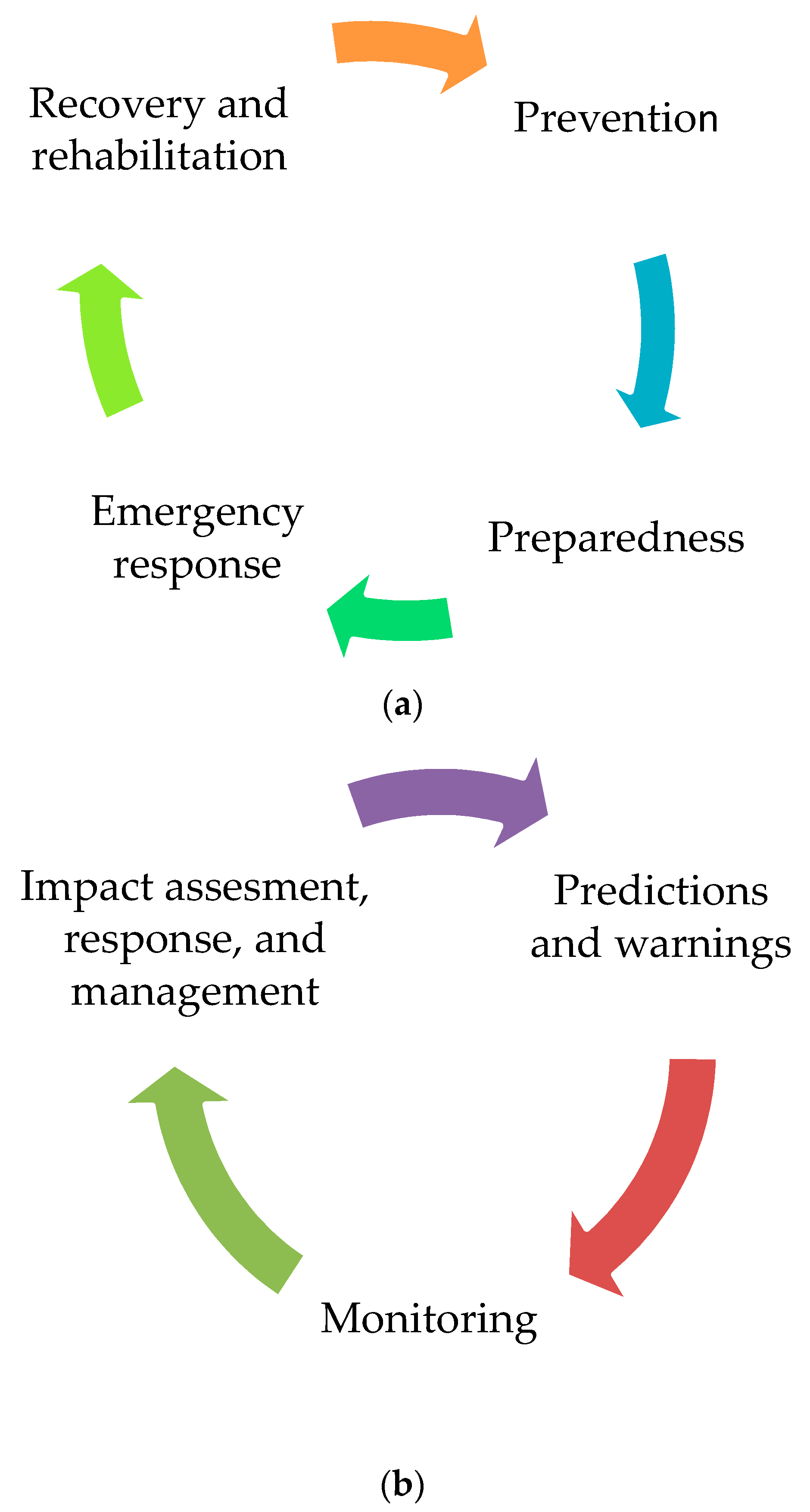
1. Introduction
2. Definition and Classification of Flood and Drought
2.1. Flood
2.2. Drought
3. Recent Research on Disaster Reduction
3.1. Prediction and Warning
3.1.1. Flood
3.1.2. Drought
3.2. Monitoring
3.3. Impact Assessment, Response, and Management
3.3.1. Flood
3.3.2. Drought
3.3.3. Other Associated Studies
4. Integration of Structural and Nonstructural Measures for Disaster Mitigation
5. Conclusions
5.1. Implications for Flood and Drought Researchers
5.2. Future Research of Interest
Author Contributions
Funding
Acknowledgments
Conflicts of Interest
References
- United Nations. Sustainable development goals. Available online: https://www.un.org/sustainabledevelopment/sustainable-development-goals/ (accessed on 26 December 2019).
- Cai, W.; Santoso, A.; Wang, G.; Yeh, S.W.; An, S.I.; Cobb, K.M.; Collins, M.; Guilyardu, E.; Jin, F.F.; Kug, S.J.; et al. ENSO and greenhouse warming. Nature Clim. Change 2015, 5, 849–859. [Google Scholar] [CrossRef]
- Center for Research on Epidemiology of Disasters (CRED). Natural Disasters; Center for Research on Epidemiology of Disasters: Brussels, Belgium, 2018. [Google Scholar]
- Mahul, O. Toward a regional approach for disaster risk finance in Asia. In Proceedings of the ICRM Symposium, Singapore, 3–4 August 2017. [Google Scholar]
- Ding, Y.; Hayes, M.J.; Widhalm, M. Measuring economic impacts of drought: A review and discussion. Disaster Prevent. Manag. An. Int. J. 2011, 20, 13. [Google Scholar] [CrossRef]
- Queensland Government, Office of the Queensland Chief Scientist. Floods have Significant Consequences for the Environment. Available online: https://www.chiefscientist.qld.gov.au/publications/understanding-floods/flood-consequences (accessed on 26 December 2019).
- Below, R.; Wirtz, A.; Guha-Sapor, D. Disaster Category Classification and Peril Terminology for Operational Purposes; Centre for Research on the Epidemiology of Disasters: Brussels, Belgium, 2009. [Google Scholar]
- Falconer, R.H.; Cobby, D.; Smyth, P.; Astle, G.; Dent, J.; Golding, B. Pluvial flooding: New approaches in flood warning, mapping and risk management. J. Flood Risk Manag. 2009, 2, 198–208. [Google Scholar] [CrossRef]
- Hurford, A.P.; Priest, S.J.; Parker, D.J.; Lumbroso, D.M. The effectiveness of extreme rainfall alerts in predicting surface water flooding in England and Wales. Int. J. Climatol. 2012, 32, 1768–1774. [Google Scholar] [CrossRef]
- Kaźmierczak, A.; Cavan, G. Surface water flooding risk to urban communities: Analysis of vulnerability, hazard and exposure. Landsc. Urban. Plan. 2011, 103, 185–197. [Google Scholar] [CrossRef]
- Houston, D.; Werrity, A.; Bassett, D.; Geddes, A.; Hoolachan, A.; McMillan, M. Pluvial (rain-related) Flooding in Urban Areas: The Invisible Hazard; Joseph Rowntree Foundation: London, UK, 2011. [Google Scholar]
- Apreda, C. Climate change, urban vulnerability and adaptation strategies to pluvial flooding. UPLanD-J. Urban. Plan. Landsc. Environ. Design 2016, 1, 233. [Google Scholar]
- Montz, B.E.; Gruntfest, E. Flash flood mitigation: Recommendations for research and applications. Global Environ. Change B Environ. Hazards 2002, 4, 15–22. [Google Scholar] [CrossRef]
- Hapuarachchi, H.A.P.; Wang, Q.J.; Pagano, T.C. A review of advances in flash flood forecasting. Hydrol. Process. 2011, 25, 2771–2784. [Google Scholar] [CrossRef]
- Lund, J.R. Flood management in California. Water 2012, 4, 157–169. [Google Scholar] [CrossRef]
- Changnon, S.A. Assessment of flood losses in the United States. J. Contemp. Water Res. Edu. 2008, 138, 38–44. [Google Scholar] [CrossRef]
- Archer, D.R.; Fowler, H.J. Characterising flash flood response to intense rainfall and impacts using historical information and gauged data in Britain. J. Flood Risk Manag. 2018, 11, S121–S133. [Google Scholar] [CrossRef]
- Liu, C.; Guo, L.; Ye, L.; Zhang, S.; Zhao, Y.; Song, T. A review of advances in China’s flash flood early-warning system. Nat. Hazard. 2018, 92, 619–634. [Google Scholar] [CrossRef]
- Acreman, M.C.; Riddington, R.; Booker, D.J. Hydrological impacts of floodplain restoration: A case study of the River Cherwell, UK. Hydrol. Earth Syst. Sci. Disc. 2003, 7, 75–85. [Google Scholar] [CrossRef]
- Acreman, M.; Arthington, A.H.; Colloff, M.J.; Couch, C.; Crossman, N.D.; Dyer, F.; Overton, I.; Pollino, C.A.; Stewarson, M.; Young, W. Environmental flows for natural, hybrid, and novel riverine ecosystems in a changing world. Front. Ecol. Environ. 2014, 12, 466–473. [Google Scholar] [CrossRef]
- Wolf, J. Coastal flooding: Impacts of coupled wave–surge–tide models. Nat. Hazard. 2009, 49, 241–260. [Google Scholar] [CrossRef]
- Heberger, M.; Cooley, H.; Herrera, P.; Gleick, P.H.; Moore, E. Potential impacts of increased coastal flooding in California due to sea-level rise. Clim. Change 2011, 109, 229–249. [Google Scholar] [CrossRef]
- Woodruff, J.D.; Irish, J.L.; Camargo, S.J. Coastal flooding by tropical cyclones and sea-level rise. Nature 2013, 504, 44. [Google Scholar] [CrossRef]
- Dawson, R.J.; Dickson, M.E.; Nicholls, R.J.; Hall, J.W.; Walkden, M.J.; Stansby, P.K.; Mokrech, M.; Richards, J.; Zhou, J.; Milligan, J.; et al. Integrated analysis of risks of coastal flooding and cliff erosion under scenarios of long term change. Clim. Change 2009, 95, 249–288. [Google Scholar] [CrossRef]
- Mishra, A.K.; Singh, V.P. A review of drought concepts. J. Hydrol. 2010, 391, 202–216. [Google Scholar] [CrossRef]
- World Meteorological Organization (WMO). Report on Drought and Countries Affected by Drought During 1974–1985; WMO: Geneva, Switzerland, 1986; p. 118. [Google Scholar]
- UN Secretariat General. United Nations Convention to Combat Drought and Desertification in Countries Experiencing Serious Droughts and Desertification, Particularly in Africa; UN Secretariat General: Paris, France, 1994. [Google Scholar]
- FAO. Report of FAO-CRIDA Expert Group Consultation on Farming System and Best Practices for Drought-Prone Areas of Asia and the Pacific Region. Food and Agricultural Organization of United Nations; Central Research Institute for Dryland Agriculture: Hyderabad, India, 2002. [Google Scholar]
- Gumbel, E.J. Statistical forecast of droughts. Bull. Int. Assoc. Sci. Hydrol. 1963, 8, 5–23. [Google Scholar] [CrossRef]
- Wilhite, D.A.; Glantz, M.H. Understanding the Drought Phenomenon: The Role of Definitions. Water Int. 1985, 10, 111–120. [Google Scholar] [CrossRef]
- American Meteorological Society (AMS). Statement on meteorological drought. Bull. Am. Meteorol. Soc. 2004, 85, 771–773. [Google Scholar]
- Kumar, R.; Musuuza, J.L.; Loon, A.F.V.; Teuling, A.J.; Barthel, R.; Broek, T.J.; Mai, J.; Samaniego, L.; Attinger, S. Multiscale evaluation of the Standardized Precipitation Index as a groundwater drought indicator. Hydrol. Earth Syst. Sci. 2016, 20, 1117–1131. [Google Scholar] [CrossRef]
- Gibbs, W.J. Drought, its definition, delineation and effects. In Drought: Lectures Presented at the 26th Session of the WMO; Report No. 5; WMO: Geneva, Switzerland, 1975; pp. 3–30. [Google Scholar]
- Haslinger, K.; Blöschl, G. Space-time patterns of meteorological drought events in the European Greater Alpine Region over the past 210 years. Water Resour. Res. 2017, 53, 9807–9823. [Google Scholar] [CrossRef]
- Schubert, S.D.; Stewart, R.E.; Wang, H.; Barlow, M.; Berbery, E.H.; Cai, W.; Hoerling, M.P.; Kanikicharta, K.K.; Koster, R.D.; Lyon, B.; et al. Global meteorological drought: A synthesis of current understanding with a focus on SST drivers of precipitation deficits. J. Clim. 2016, 29, 3989–4019. [Google Scholar] [CrossRef]
- Van Loon, A.F. Hydrological drought explained. WIRES Water 2015, 2, 359–392. [Google Scholar] [CrossRef]
- Hasan, H.H.; Razali, M.; Fatin, S.; Muhammad, N.S.; Ahmad, A. Research trends of hydrological drought: A systematic review. Water 2019, 11, 2252. [Google Scholar] [CrossRef]
- Sheffield, J.; Wood, E.F. Drought: Past and Future Scenarios; Earthscan Ltd.: London, UK, 2011. [Google Scholar]
- Allah, A.A.D.; Hashim, N.B.M.; Awang, A.B. Discovering trends of agricultural drought in Tihama Plain, Yemen: A preliminary assessment. Indonesian J. Geogr. 2017, 49, 17. [Google Scholar]
- Liu, Y.; Pan, Z.; Zhuang, Q.; Miralles, D.G.; Teuling, A.J.; Zhang, T.; An, P.; Dong, Z.; Zhang, J.; He, D.; et al. Agriculture intensifies soil moisture decline in Northern China. Sci. Rep. 2015, 5, 11261. [Google Scholar] [CrossRef]
- Guo, Y.; Huang, S.; Huang, Q.; Wang, H.; Fang, W.; Yang, Y.; Wang, L. Assessing socioeconomic drought based on an improved Multivariate Standardized Reliability and Resilience Index. J. Hydrol. 2019, 568, 904–918. [Google Scholar] [CrossRef]
- Chan, N.W.; Ghani, A.A.; Samat, N.; Hasan, N.N.N.; Tan, M.L. Integrating structural and non-structural flood management measures for greater effectiveness in flood loss reduction in the Kelantan River Basin, Malaysia. In Proceedings of the AICCE’19, AICCE 2019, Lecture Notes in Civil Engineering; Mohamed, N.F., Ed.; Springer: Berlin/Heidelberg, Germany, 2020; p. 53. [Google Scholar]
- Kundzewicz, Z.W.; Hegger, D.L.T.; Matczak, P.; Driessen, P.P.J. Opinion: Flood-risk reduction: Structural measures and diverse strategies. Proc. Nat. Academ. Sci USA 2018, 115, 12321–12325. [Google Scholar] [CrossRef]
- Li, C.; Cheng, X.; Li, N.; Du, X.; Yu, Q.; Kan, G. A framework for flood risk analysis and benefit assessment of flood control measures in urban areas. Int. J. Environ. Res. Publ. Health 2016, 13, 787. [Google Scholar] [CrossRef]
- Albuquerque, M.B.; de Araújo, A.A.; Martinez, C.E.N.M.; Mauad, F.F.; Okawa, C.M.P. Sustainable Urban Drainage: A brief review of the compensatory techniques of structural and non-structural measures. Revista Eletrônica em Gestão, Educação e Tecnologia Ambiental 2019, 23, 35. [Google Scholar]
- Enomoto, C.F. Método para elaboração de mapas de inundação: Estudo de caso na bacia do rio Palmital. Ph.D. Thesis, Setor de Tecnologia/Universidade Federal do Paraná, Curitiba, Brazil, 2004. [Google Scholar]
- Kawatoko, I.E.S. Estabelecimento de cenários de medidas estruturais e não estruturais para gestão das águas urbanas em escala de lote. Ph.D. Thesis, Escola de Engenharia de São Carlos/USP, São Carlos, Brazil, 2012. [Google Scholar]
- Velasco, M.; Russo, B.; Cabello, À.; Termes, M.; Sunyer, D.; Malgrat, P. Assessment of the effectiveness of structural and nonstructural measures to cope with global change impacts in Barcelona. J. Flood Risk Manag. 2018, 11, S55–S68. [Google Scholar] [CrossRef]
- Rossi, G. Drought mitigation measures: A comprehensive framework. In Drought and Drought Mitigation in Europe. Advances in Natural and Technological Hazards Research; Vogt, J.V., Somma, F., Eds.; Springer: Dordrecht, The Netherlands, 2000; p. 14. [Google Scholar]
- Klomp, J.; Hoogezand, B. Natural disasters and agricultural protection: A panel data analysis. World Develop. 2018, 104, 404–417. [Google Scholar] [CrossRef]
- Rogers, D.; Tsirkunov, V. Costs and Benefits of Early warning Systems. Available online: https://www.preventionweb.net/english/hyogo/gar/2011/en/bgdocs/Rogers_&_Tsirkunov_2011.pdf (accessed on 20 January 2020).
- Sättele, M.; Bründl, M.; Straub, D. Reliability and effectiveness of early warning systems for natural hazards: Concept and application to debris flow warning. Reliab. Eng. Syst. Saf. 2015, 142, 192–202. [Google Scholar] [CrossRef]
- Teng, J.; Jakeman, A.J.; Vaze, J.; Croke, B.F.; Dutta, D.; Kim, S. Flood inundation modelling: A review of methods, recent advances and uncertainty analysis. Environ. Model. Softw. 2017, 90, 201–216. [Google Scholar] [CrossRef]
- U.S. Army. HEC RAS River Analysis System. User’s Manual, Version 5; US Army Corps of Engineers: Sacramento, CA, USA, 2016.
- Rojas, O.; Mardones, M.; Rojas, C.; Martínez, C.; Flores, L. Urban growth and flood disasters in the coastal river basin of south-central Chile (1943–2011). Sustainability 2017, 9, 195. [Google Scholar] [CrossRef]
- Gibson, S.; Sánchez, A.; Piper, S.; Brunner, G. New One-dimensional sediment features in HEC-RAS 5.0 and 5.1. In Proceedings of the World Environmental and Water Resources Congress, Sacramento, CA, USA, 21–25 May 2017; pp. 192–206. [Google Scholar]
- Kilania, S.; Chahar, B.R. A dam break analysis using HEC-RAS. In World Environmental and Water Resources Congress, Hydraulics, Waterways, and Water Distribution Systems Analysis; American Society of Civil Engineers: Reston, VA, USA, 2019; pp. 382–389. [Google Scholar]
- Quirogaa, V.M.; Kurea, S.; Udoa, K.; Manoa, A. Application of 2D numerical simulation for the analysis of the February 2014 Bolivian Amazonia flood: Application of the new HEC-RAS version 5. Ribagua 2016, 3, 25–33. [Google Scholar] [CrossRef]
- DHI. MIKE. 21-2D Modelling of Coast and Sea; DHI Water & Environment Pty Ltd.: Hørsholm, Denmark, 2012. [Google Scholar]
- Shih, S.S.; Kuo, P.H.; Lai, J.S. A nonstructural flood prevention measure for mitigating urban inundation impacts along with river flooding effects. J. Environ. Manag. 2019, 251, 109553. [Google Scholar] [CrossRef]
- Doong, D.J.; Lo, W.; Vojinovic, Z.; Lee, W.L.; Lee, S.P. Development of a new generation of flood inundation maps-A case study of the coastal city of Tainan, Taiwan. Water 2016, 8, 521. [Google Scholar] [CrossRef]
- Shukla, M. (Ed.) . Soil hydrology, Land use and Agriculture: Measurement and Modelling; Cabi: Wallingford, UK, 2011. [Google Scholar]
- Sith, R.; Nadaoka, K. Comparison of SWAT and GSSHA for high time resolution prediction of stream flow and sediment concentration in a small agricultural watershed. Hydrology 2017, 4, 27. [Google Scholar] [CrossRef]
- Sommerlot, A.R.; Nejadhashemi, A.P.; Woznicki, S.A.; Giri, S.; Prohaska, M.D. Evaluating the capabilities of watershed-scale models in estimating sediment yield at field-scale. J. Environ. Manag. 2013, 127, 228–236. [Google Scholar] [CrossRef] [PubMed]
- De Girolamo, A.M.; Lo Porto, A.; Pappagallo, G.; Tzoraki, O.; Gallart, F. The hydrological status concept: Application at a temporary River (Candelaro, Italy). River Res. Appl. 2015, 31, 892–903. [Google Scholar] [CrossRef]
- Abdelwahab, O.M.M.; Bingner, R.L.; Milillo, F.; Gentile, F. Effectiveness of alternative management scenarios on the sediment load in a Mediterranean agricultural watershed. J. Agric. Eng. 2014, 45, 125–136. [Google Scholar] [CrossRef]
- Mtibaa, S.; Hotta, N.; Irie, M. Analysis of the efficacy and cost-effectiveness of best management practices for controlling sediment yield: A case study of the Joumine watershed, Tunisia. Sci. Total Environ. 2018, 616–617, 1–16. [Google Scholar] [CrossRef]
- Ricci, G.F.; Jeong, J.; De Girolamo, A.M.; Gentile, F. Effectiveness and feasibility of different management practices to reduce soil erosion in an agricultural watershed. Land Use Policy 2020, 90, 104306. [Google Scholar] [CrossRef]
- Lin, G.F.; Lin, H.Y.; Chou, Y.C. Development of a real-time regional-inundation forecasting model for the inundation warning system. J. Hydroinform. 2013, 15, 1391–1407. [Google Scholar] [CrossRef]
- Pan, T.Y.; Lin, H.T.; Liao, H.Y. A data-driven probabilistic rainfall-inundation model for flash-flood warnings. Water 2019, 11, 2534. [Google Scholar] [CrossRef]
- Badrzadeh, H.; Sarukkalige, R.; Jayawardena, A.W. Hourly runoff forecasting for flood risk management: Application of various computational intelligence models. J. Hydrol. 2015, 529, 1633–1643. [Google Scholar] [CrossRef]
- Lhomme, J.; Sayers, P.B.; Gouldby, B.P.; Samuels, P.G.; Wills, M.; Mulet-Marti, J. Recent development and application of a rapid flood spreading method. In Proceedings of the Conference FLOODrisk 2008, Flood Risk Management: Research and Practice, Oxford, UK, 30 September–2 October 2009. [Google Scholar]
- Yang, T.H.; Chen, Y.C.; Chang, Y.C.; Yang, S.C.; Ho, J.Y. Comparison of different grid cell ordering approaches in a simplified inundation model. Water 2015, 7, 438–454. [Google Scholar] [CrossRef]
- Yang, T.H.; Hwang, G.D.; Tsai, C.C.; Ho, J.Y. Using rainfall thresholds and ensemble precipitation forecasts to issue and improve urban inundation alerts. Hydrol. Earth Syst. Sci. 2016, 20, 4731–4745. [Google Scholar] [CrossRef]
- Martina, M.L.V.; Todini, E.; Libralon, A. A Bayesian decision approach to rainfall thresholds based flood warning. Hydrol. Earth Syst. Sci. 2006, 10, 316–324. [Google Scholar] [CrossRef]
- Anshuka, A.; van Ogtrop, F.F.; Vervoort, R.W. Drought forecasting through statistical models using standardised precipitation index: A systematic review and meta-regression analysis. Nat. Hazard. 2019, 97, 955–977. [Google Scholar] [CrossRef]
- Yeh, H.F.; Hsu, H.L. Stochastic model for drought forecasting in the Southern Taiwan Basin. Water 2019, 11, 2041. [Google Scholar] [CrossRef]
- Fung, K.F.; Huang, Y.F.; Koo, C.H.; Soh, Y.W. Drought forecasting: A review of modelling approaches 2007–2017. J. Water Clim. Change 2019, 236. [Google Scholar] [CrossRef]
- Mishra, A.K.; Singh, V.P. Drought modeling–A review. J. Hydrol. 2011, 403, 157–175. [Google Scholar] [CrossRef]
- Luo, L.; Wood, E.F. Monitoring and predicting the 2007 US drought. Geophys. Res. Lett. 2007, 34, L22702. [Google Scholar] [CrossRef]
- Bae, D.H.; Son, K.H.; Ahn, J.B.; Hong, J.Y.; Kim, G.S.; Chung, J.S.; Jung, U.S.; Kim, J.K. Development of real-time drought monitoring and prediction system on Korea & East Asia region. Atmosphere 2012, 22, 267–277. [Google Scholar]
- Li, Y.; Yuan, X.; Zhang, H.; Wang, R.; Wang, C.; Meng, X.; Zhang, Z.; Wang, S.; Yang, Y.; Han, B.; et al. Mechanisms and early warning of drought disasters: Experimental drought meteorology research over China. Bull. Am. Meteorol. Soc. 2019, 100, 673–687. [Google Scholar] [CrossRef]
- Forni, L.G.; Medellín-Azuara, J.; Tansey, M.; Young, C.; Purkey, D.; Howitt, R. Integrating complex economic and hydrologic planning models: An application for drought under climate change analysis. Water Resour. Economics 2016, 16, 15–27. [Google Scholar] [CrossRef]
- Svoboda, M.; Fuchs, B. Handbook of Drought Indicators and Indices; WMO-No. 1173; World Meteorological Organization: Geneva, Switzerland, 2016. [Google Scholar]
- Bahrami, M.; Bazrkar, S.; Zarei, A.R. Modeling, prediction and trend assessment of drought in Iran using standardized precipitation index. J. Water Clim. Change 2019, 10, 181–196. [Google Scholar] [CrossRef]
- Choubin, B.; Malekian, A.; Golshan, M. Application of several data-driven techniques to predict a standardized precipitation index. Atmósfera 2016, 29, 121–128. [Google Scholar] [CrossRef]
- McKinnon, K.A.; Rhines, A.; Tingley, M.P.; Huybers, P. Long-lead predictions of eastern United States hot days from Pacific sea surface temperatures. Nat. Geosci. 2016, 9, 389–394. [Google Scholar] [CrossRef]
- Adamowski, J.; Belayneh, A. Drought Forecasting. Exploring Natural Hazards: A Case Study Approach, 207; Taylor & Francis Group: Abingdon, UK, 2018. [Google Scholar]
- Kousari, M.R.; Hosseini, M.E.; Ahani, H.; Hakimelahi, H. Introducing an operational method to forecast long-term regional drought based on the application of artificial intelligence capabilities. Theor. Appl. Climatol. 2017, 127, 361–380. [Google Scholar] [CrossRef]
- Mokhtarzad, M.; Eskandari, F.; Vanjani, N.J.; Arabasadi, A. Drought forecasting by ANN, ANFIS, and SVM and comparison of the models. Environ. Earth Sci. 2017, 76, 729. [Google Scholar] [CrossRef]
- Maca, P.; Pech, P. Forecasting SPEI and SPI drought indices using the integrated artificial neural networks. Comput. Intell. Neurosci. 2016, 3, 1–17. [Google Scholar] [CrossRef]
- Gourley, J.J.; Flamig, Z.L.; Vergara, H.; Kirstetter, P.E.; Clark III, R.A.; Argyle, E.; Arthur, A.; Martinaitis, S.; Terti, G.; Erlingis, J.M.; et al. The FLASH Project: Improving the tools for flash flood monitoring and prediction across the United States. Bull. Am. Meteorol.l Soc. 2017, 98, 361–372. [Google Scholar] [CrossRef]
- López-Trujillo, D. Real Time Flood Alert System (RTFAS) for Puerto Rico; US Department of Interior, US Geological Survey: Washington, DC, USA, 2010.
- Ceppi, A.; Ravazzani, G.; Corbari, C.; Salerno, R.; Meucci, S.; Mancini, M. Real-time drought forecasting system for irrigation management. Procedia Environ. Sci. 2014, 19, 776–784. [Google Scholar] [CrossRef]
- Hossain, F. Towards formulation of a space-borne system for early warning of floods: Can cost-effectiveness outweigh prediction uncertainty? Nat. Hazard. 2006, 37, 263–276. [Google Scholar] [CrossRef]
- Wei, L.; Jiang, S.; Ren, L.; Yuan, F.; Zhang, L. Performance of Two Long-Term Satellite-Based and GPCC 8.0 Precipitation Products for Drought Monitoring over the Yellow River Basin in China. Sustainability 2019, 11, 4969. [Google Scholar] [CrossRef]
- Wang, L.; Qu, J.J. NMDI: A normalized multi-band drought index for monitoring soil and vegetation moisture with satellite remote sensing. Geophys. Res. Lett. 2007, 34. [Google Scholar] [CrossRef]
- Hazaymeh, K.; Hassan, Q.K. Remote sensing of agricultural drought monitoring: A state of art review. Aims Environ. Sci. 2016, 3, 604. [Google Scholar] [CrossRef]
- Ahmadalipour, A.; Moradkhani, H.; Yan, H.; Zarekarizi, M. Remote sensing of drought: Vegetation, soil moisture, and data assimilation. In Remote Sensing of Hydrological Extremes; Springer: Berlin/Heidelberg, Germany, 2017; pp. 121–149. [Google Scholar]
- Dance, S.L.; Ballard, S.P.; Bannister, R.N.; Clark, P.; Cloke, H.L.; Darlington, T.; Flack, D.L.A.; Gray, S.L.; Hawkness-Smith, L.; Husnoo, N.; et al. Improvements in forecasting intense rainfall: Results from the FRANC (Forecasting Rainfall exploiting new data Assimilation techniques and Novel observations of Convection) project. Atmosphere 2019, 10, 125. [Google Scholar] [CrossRef]
- Van Wesemael, A.; Landuyt, L.; Lievens, H.; Verhoest, N.E. Improving flood inundation forecasts through the assimilation of in situ floodplain water level measurements based on alternative observation network configurations. Adv. Water Resour. 2019, 130, 229–243. [Google Scholar] [CrossRef]
- Chao, L.; Zhang, K.; Li, Z.; Zhu, Y.; Wang, J.; Yu, Z. Geographically weighted regression based methods for merging satellite and gauge precipitation. J. Hydrol. 2018, 558, 275–289. [Google Scholar] [CrossRef]
- Clement, M.A.; Kilsby, C.G.; Moore, P. Multi-temporal synthetic aperture radar flood mapping using change detection. J. Flood Risk Manag. 2018, 11, 152–168. [Google Scholar] [CrossRef]
- Munasinghe, D.; Cohen, S.; Huang, Y.F.; Tsang, Y.P.; Zhang, J.; Fang, Z. Intercomparison of Satellite Remote Sensing-Based Flood Inundation Mapping Techniques. J. Am. Water Resour. Assoc. 2018, 54, 834–846. [Google Scholar] [CrossRef]
- Uddin, K.; Matin, M.A.; Meyer, F.J. Operational flood mapping using multi-temporal sentinel-1 SAR images: A case study from Bangladesh. Remote Sens. 2019, 11, 1581. [Google Scholar] [CrossRef]
- Bozza, A.; Durand, A.; Confortola, G.; Soncini, A.; Allenbach, B.; Bocchiola, D. Potential of remote sensing and open street data for flood mapping in poorly gauged areas: A case study in Gonaives, Haiti. Appl. Geomatics 2016, 8, 117–131. [Google Scholar] [CrossRef]
- Chen, H.; Chandrasekar, V.; Bechini, R. An improved dual-polarization radar rainfall algorithm (DROPS2. 0): Application in NASA IFloodS field campaign. J. Hydrometeor. 2017, 18, 917–937. [Google Scholar] [CrossRef]
- Yang, Z.; Hsu, K.; Sorooshian, S.; Xu, X.; Braithwaite, D.; Verbist, K.M. Bias adjustment of satellite-based precipitation estimation using gauge observations: A case study in Chile. J. Geophysi. Res. Atmos. 2016, 121, 3790–3806. [Google Scholar] [CrossRef]
- Kimani, M.W.; Hoedjes, J.C.; Su, Z. An assessment of satellite-derived rainfall products relative to ground observations over East Africa. Remote Sens. 2017, 9, 430. [Google Scholar] [CrossRef]
- Teegavarapu, R.S.; Aly, A.; Pathak, C.S.; Ahlquist, J.; Fuelberg, H.; Hood, J. Infilling missing precipitation records using variants of spatial interpolation and data-driven methods: Use of optimal weighting parameters and nearest neighbour-based corrections. Int. J. Climatol. 2018, 38, 776–793. [Google Scholar] [CrossRef]
- Hunziker, S.; Gubler, S.; Calle, J.; Moreno, I.; Andrade, M.; Velarde, F.; Ticona, L.; CarroscO, G.; Castellon, Y.; Croci-Maspoli, M.; et al. Identifying, attributing, and overcoming common data quality issues of manned station observations. Int. J. Climatol. 2017, 37, 4131–4145. [Google Scholar] [CrossRef]
- Ha, J.H.; Kim, Y.H.; Im, H.H.; Kim, N.Y.; Sim, S.; Yoon, Y. Error correction of meteorological data obtained with mini-AWSs based on machine learning. Adv. Meteorol. 2018, 1–8. [Google Scholar] [CrossRef]
- Ghapar, A.A.; Yussof, S.; Bakar, A.A. Internet of Things (IoT) architecture for flood data management. Int. J. Future Gene. Commun. Network. 2018, 11, 55–62. [Google Scholar] [CrossRef]
- Bande, S.; Shete, V.V. Smart flood disaster prediction system using IoT & neural networks. In Proceedings of the International Conference on Smart Technologies for Smart Nation (SmartTechCon), Bangalore, India, 17–19 August 2017; pp. 189–194. [Google Scholar]
- Chwala, C.; Kunstmann, H. Commercial microwave link networks for rainfall observation: Assessment of the current status and future challenges. WIRES Water 2019, 6, 1337. [Google Scholar] [CrossRef]
- Mishra, B.K.; Thakker, D.; Mazumdar, S.; Simpson, S.; Neagu, D. Using deep learning for IoT-enabled camera: A use case of flood monitoring. In Proceedings of the 10th International Conference on Dependable Systems, Services and Technologies (DESSERT), Leeds, UK, 5–7 June 2019; pp. 235–240. [Google Scholar]
- Tauro, F.; Olivieri, G.; Petroselli, A.; Porfiri, M.; Grimaldi, S. Flow monitoring with a camera: A case study on a flood event in the Tiber River. Environ. Monitor. Assess. 2016, 188, 118. [Google Scholar] [CrossRef]
- De Vos, L.W.; Leijnse, H.; Overeem, A.; Uijlenhoet, R. Quality Control for Crowdsourced Personal Weather Stations to Enable Operational Rainfall Monitoring. Geophys. Res. Lette. 2019, 46, 8820–8829. [Google Scholar] [CrossRef]
- Engel, F.L.; Choi, N. Flood warning toolset for the Medina River in Bandera County, Texas: U.S. Geological Survey Fact. Sheet, 2019–3043. Available online: https://doi.org/10.3133/fs20193043. (accessed on 20 January 2020).
- Ghimire, E. Evaluation of one-dimensional and two-dimensional HEC-RAS models for flood travel time prediction and damage assessment using HAZUS-MH: A case study of Grand River, Ohio. (Electronic Thesis or Dissertation. 2019. Available online: https://etd.ohiolink.edu/ (accessed on 20 January 2020).
- Sosa, J.; Sampson, C.; Smith, A.; Neal, J.; Bates, P. A toolbox to quickly prepare flood inundation models for LISFLOOD-FP simulations. Environm. Model. Softw. 2020, 123, 104561. [Google Scholar] [CrossRef]
- Grimaldi, S.; Xu, J.; Li, Y.; Pauwels, V.R.; Walker, J.P. Flood mapping under vegetation using single SAR acquisitions. Remote Sens. Environ. 2020, 237, 111582. [Google Scholar] [CrossRef]
- Ritter, J.; Berenguer, M.; Corral, C.; Park, S.; Sempere-Torres, D. ReAFFIRM: Real-time assessment of flash flood impacts–a regional high-resolution method. Environ. Int. 2020, 136, 105375. [Google Scholar] [CrossRef] [PubMed]
- Sutanto, S.J.; van der Weert, M.; Wanders, N.; Blauhut, V.; Van Lanen, H.A. Moving from drought hazard to impact forecasts. Nat. Commun. 2019, 10, 1–7. [Google Scholar] [CrossRef] [PubMed]
- De Silva, M.M.G.T.; Kawasaki, A. Socioeconomic vulnerability to disaster risk: A case study of flood and drought impact in a rural Sri Lankan community. Ecol. Econ. 2018, 152, 131–140. [Google Scholar] [CrossRef]
- Raikes, J.; Smith, T.F.; Jacobson, C.; Baldwin, C. Pre-disaster planning and preparedness for floods and droughts: A systematic review. Int. J. Disast. Risk Red. 2019, 38, 101207. [Google Scholar] [CrossRef]
- Wilhite, D.; Easterling, W.; Wood, D.A.; Rasmusson, E. Planning for Drought: Toward a Reduction of Societal Vulnerability; Routledge: Abingdon, UK, 2019. [Google Scholar]
- Olyazadeh, R.; Aye, Z.C.; Jaboyedoff, M.; Derron, M.H. Prototype of an open-source web-GIS platform for rapid disaster impact assessment. Spat. Inform. Res. 2016, 24, 203–210. [Google Scholar] [CrossRef]
- Ahamed, A.; Bolten, J.; Doyle, C.; Fayne, J. Near real-time flood monitoring and impact assessment systems. In Remote Sensing of Hydrological Extremes; Springer: Berlin/Heidelberg, Germany, 2017; pp. 105–118. [Google Scholar]
- Oddo, P.C.; Ahamed, A.; Bolten, J.D. Socioeconomic impact evaluation for near real-time flood detection in the lower Mekong river basin. Hydrol. 2018, 5, 23. [Google Scholar] [CrossRef]
- West, H.; Quinn, N.; Horswell, M. Remote sensing for drought monitoring & impact assessment: Progress, past challenges and future opportunities. Remote Sens. Environ. 2019, 232, 111291. [Google Scholar]
- Hegger, D.L.; Driessen, P.P.; Dieperink, C.; Wiering, M.; Raadgever, G.T.; van Rijswick, H.F. Assessing stability and dynamics in flood risk governance. Water Resour. Manag. 2014, 28, 4127–4142. [Google Scholar] [CrossRef]
- Wilhite, D.A. National Drought Management Policy Guidelines: A Template for Action; Integrated Drought Management Programme (IDMP) Tools and Guidelines Series; World Meteorological Organization: Geneva, Switzerland, 2015; p. 1. [Google Scholar]
- Łabędzki, L. Actions and measures for mitigation drought and water scarcity in agriculture. J. Water Land Develop. 2016, 29, 3–10. [Google Scholar] [CrossRef]
- Müller, A.; Mora, V.; Rojas, E.; Díaz, J.; Fuentes, O.; Giron, E.; Gaytan, A.; van Etten, J. Emergency drills for agricultural drought response: A case study in Guatemala. Disasters 2019, 43, 410–430. [Google Scholar] [CrossRef] [PubMed]
- Li, X.; Yang, Y.; Poon, J.; Liu, Y.; Liu, H. Anti-drought measures and their effectiveness: A study of farmers’ actions and government support in China. Ecol. Indic. 2018, 87, 285–295. [Google Scholar] [CrossRef]
- Hyogo Declaration. In Proceedings of the World Conference on Disaster Reduction: International strategy for disaster reduction, Hyogo, Japan, 18–22 January 2005.
- Yamada, F.; Kakimoto, R.; Yamamoto, M.; Fujimi, T.; Tanaka, N. Implementation of community flood risk communication in Kumamoto, Japan. J. Aav. Transport. 2011, 45, 117–128. [Google Scholar] [CrossRef]
- Shaw, R. Critical issues of community based flood mitigation: Examples from Bangladesh and Vietnam. Sci. Cult. 2006, 72, 6. [Google Scholar]
- Wallace, M.; Webber, L. The Disaster Recovery Handbook: A Step-By-Step Plan to Ensure Business Continuity and Protect Vital Operations, Facilities, and Assets; Amacom: New York, NY, USA, 2017. [Google Scholar]
- Hatton, T.; Grimshaw, E.; Vargo, J.; Seville, E. Lessons from disaster: Creating a business continuity plan that really works. J. Bus. Contin. Emer. Plan. 2016, 10, 84–92. [Google Scholar]
- Yang, T.H.; Yang, S.C.; Kao, H.M.; Wu, M.C.; Hsu, H.M. Cyber-physical-system-based smart water system to prevent flood hazards. Smart Water 2018, 3, 1. [Google Scholar] [CrossRef]
- Lehner, B.; Döll, P.; Alcamo, J.; Henrichs, T.; Kaspar, F. Estimating the impact of global change on flood and drought risks in Europe: A continental, integrated analysis. Clim. Change 2006, 75, 273–299. [Google Scholar] [CrossRef]
- Marengo, J.A.; Tomasella, J.; Nobre, C.A. Climate change and water resources. In Waters of Brazil; Springer: Cham, Switzerland, 2017; pp. 171–186. [Google Scholar]
- Casagli, N.; Frodella, W.; Morelli, S.; Tofani, V.; Ciampalini, A.; Intrieri, E.; Raspini, F.; Rossi, G.; Tanteri, L.; Lu, P. Spaceborne, UAV and ground-based remote sensing techniques for landslide mapping, monitoring and early warning. Geoenviron. Disast. 2017, 4, 9. [Google Scholar] [CrossRef]
- Cai, J.; Kummu, M.; Niva, V.; Guillaume, J.H.; Varis, O. Exposure and resilience of China’s cities to floods and droughts: A double-edged sword. Int. J. Water Resour. Develop. 2018, 34, 547–565. [Google Scholar] [CrossRef]
- Zhao, H.; Zou, C.; Zhao, J.; Li, X. Role of low-impact development in generation and control of urban diffuse pollution in a pilot sponge city: A paired-catchment study. Water 2018, 10, 852. [Google Scholar] [CrossRef]
- Jia, H.; Wang, Z.; Zhen, X.; Clar, M.; Shaw, L.Y. China’s sponge city construction: A discussion on technical approaches. Front. Environ. Sci. Eng. 2017, 11, 18. [Google Scholar] [CrossRef]
- Tanaka, S.K.; Zhu, T.; Lund, J.R.; Howitt, R.E.; Jenkins, M.W.; Pulido, M.A.; Tauber, M.; Ritzema, R.S.; Ferreira, I.C. Climate warming and water management adaptation for California. Clim. Change 2006, 76, 361–387. [Google Scholar] [CrossRef]


| Disaster Classification | Definition | Reference |
|---|---|---|
| Flood | ||
| Pluvial | The rate of precipitation falling on an area exceeds the infiltration rate into the ground. | [8,9,10,11,12,13,14] |
| Fluvial | The excessive amount of rainfall exceeds the capacity of a river. | [15,16,17,18,19,20] |
| Coastal | Flood in low-lying areas is usually caused by wind waves and elevated water level. | [21,22,23,24] |
| Drought | ||
| Meteorological | Precipitation deficits occur over a region for a period of time. | [33,34,35] |
| Hydrological | Surface and subsurface water resources are not enough to meet water supplies of a given water resources management system. | [36,37,38] |
| Agricultural | Declining soil moisture and consequent crop failure are without any reference to surface water resources. | [35,39,40] |
| Socio-economic | The demand for an economic good exceeds supply of a weather-related shortfall in water supply. | [41] |
| Research Theme | Disaster Type | |
|---|---|---|
| Prediction and Warning | Flood Physics-based models [53,54,55,56,57,58,59,60,61] Data-driven models [69,70,71] Other alternatives: rainfall threshold/index-based models [72,73,74] | |
| Drought Statistic models [78,79] Dynamic models [80,81,82] Monitoring information and index-based monitoring [85,86,87] Data-driven models [88,89,90,91] | ||
| Monitoring | Traditional observation approach [92,94] Remote sensing techniques [96,97,98] Advanced monitoring network [115,116,117,118] | |
| Impact Assessment, Response, and Management | Climate change or planning-related assessment [125,126,127] Immediate disaster evaluation and response [128,129,130] | General measures to mitigate the drought impact [127] Specific measures for agriculture drought [134,135,136] |
| Strategy | Measure | Disaster Type | |
|---|---|---|---|
| Structure | Nonstructural | Flood | |
| Monitoring | Establishment of monitoring network (gauging stations, satellite, etc.) | Precipitation, river stage, soil moisture, and, etc. | |
| Prediction and warning | n/a | Numerical models | River stage or urban inundation forecasting |
| Impact assessment | n/a | Numerical models | Evaluation of flood-affected area and population |
| Response and management | Reservoir, levee, emergency diversion channel, temporary flood wall, water pump, etc. | Evacuation, land-use planning, flood insurance, flood-adopted design and use of buildings, etc. | Prevention of flooding and decrease the damage to life and property |
| Strategy | Measure | Disaster type | |
|---|---|---|---|
| Structure | Nonstructural | Drought | |
| Monitoring | Establishment of monitoring network (gauging stations, satellite, etc.) | Precipitation, river stage, soil moisture, etc. | |
| Prediction and warning | n/a | Numerical models | Standardized precipitation index |
| Impact assessment | n/a | Numerical models | Estimation of drought duration and severity |
| Response and management | Reservoir, maintenance of water conveyance system, wastewater recycling, etc. | Low water pressure, water supply reduction, compensation to stop farming, etc. | Decrease the socioeconomic impact of drought |
© 2020 by the authors. Licensee MDPI, Basel, Switzerland. This article is an open access article distributed under the terms and conditions of the Creative Commons Attribution (CC BY) license (http://creativecommons.org/licenses/by/4.0/).
Share and Cite
Yang, T.-H.; Liu, W.-C. A General Overview of the Risk-Reduction Strategies for Floods and Droughts. Sustainability 2020, 12, 2687. https://doi.org/10.3390/su12072687
Yang T-H, Liu W-C. A General Overview of the Risk-Reduction Strategies for Floods and Droughts. Sustainability. 2020; 12(7):2687. https://doi.org/10.3390/su12072687
Chicago/Turabian StyleYang, Tsun-Hua, and Wen-Cheng Liu. 2020. "A General Overview of the Risk-Reduction Strategies for Floods and Droughts" Sustainability 12, no. 7: 2687. https://doi.org/10.3390/su12072687
APA StyleYang, T.-H., & Liu, W.-C. (2020). A General Overview of the Risk-Reduction Strategies for Floods and Droughts. Sustainability, 12(7), 2687. https://doi.org/10.3390/su12072687