Article

Accessibility to Food Retailers: The Case of Belo Horizonte, Brazil

1
Department of Applied Social Sciences, Federal Center for Technological Education of Minas Gerais—CEFET-MG, Belo Horizonte 30510-000, Brazil
2
Instituto Superior Técnico, Universidade de Lisboa, Lisboa 1049-001, Portugal
3
Department of Transport and Geotechnical Engineering, Federal University of Minas Gerais, Belo Horizonte 31.270-901, Brazil
*
Author to whom correspondence should be addressed.
Sustainability 2020, 12(7), 2654; https://doi.org/10.3390/su12072654
Submission received: 6 February 2020 / Revised: 11 March 2020 / Accepted: 13 March 2020 / Published: 27 March 2020
(This article belongs to the Special Issue City Logistics)

Abstract

:
Access to food products is essential to sustain life. In this paper, we discuss the differences concerning accessibility levels to food retailers among potential consumers in Belo Horizonte, Brazil. The goal was to characterize spatial mismatches regarding opportunities to access food and identify suitable areas for sustainable last food mile solutions, such as non-motorized home delivery and purchase trips. For this, we have spatially related: (i) the population concentration; (ii) the income of households and (iii) accessibility measures considering both the spatial structure of food retailers and the distance between households and stores, considering the food last mile. We have then used spatial statistics (Global Moran’s I index, average nearest neighborhood analysis) and spatial analyses (overlay and processing) to determine the spatial pattern and the relation of the variables population, income, and accessibility to food retailers. We have considered the cumulative-opportunity measure, which is an indicator of the number of opportunities that can be reached within a time threshold. There is great spatial differentiation regarding the accessibility levels of food retailers and the results can be considered to support the development of policy and land use regulation that can stimulate non-motorized and collaborative delivery as an effective last-mile solution.

1. Introduction and Background

The concentration of people in cities is a growing worldwide phenomenon and, by 2050, there will be at least nine billion people in the world, with two-thirds of them living in cities [1,2]. Thus, the consumption of food products will be concentrated in urban areas while mainly produced in rural regions. These products need to reach consumers through a complex supply chain, which comprises different stakeholders, facilities, territories and decision-making processes. As a result of the urbanization process, citizens increasingly demand food supplies in cities and this upward trend must be accommodated in urban freight distribution systems [3]. Even though urban freight transport is an essential activity for the development of cities and the maintenance of the urban lifestyle, the movement of goods is responsible for negative externalities such as greenhouse gas emissions, noise and congestion [4].
Freight transportation has acquired some relevance in urban planning policy, especially in large cities and even in the Latin American context [5,6]. City logistics, a concept defined as “the process for totally optimizing the logistics and transport activities by private companies with support of advanced information systems in urban areas considering the traffic environment, the traffic congestion, the traffic safety and the energy savings within the framework of a market economy” [7], have incorporated social and environmental issues [8], highlighting its importance for the promotion of livable and sustainable cities. Therefore, city logistics solutions, such as the optimization of logistics facilities to diminish vehicle miles traveled and urban/logistics sprawling [9], and the choice of less polluting transportation alternatives [8], among others, have acquired relevance in urban planning. Despite its importance, in Latin American cities, city logistics solutions are still not broadly explored by local public authorities in decision-making. Also, most of the indicators considered to include freight movement in urban plans, in this geographic context, are not based on the spatial structure of the city [6,10,11,12].
For cities located in developing countries, specific challenges might affect urban logistics operations, such as: high population density, rapid and disorganized population growth, underdeveloped infrastructure, fragmented industry, diversity among logistics operators’ resources, wide-ranging informal sector and increased motorization [13,14]. Along with these structural attributes, at the beginning of this century, there have been significant changes in the retail structure and shopping habits in emerging economies, especially regarding consumers’ behaviors [14]. In wealthier urban areas of these countries, e-commerce has been replacing part of the conventional retail shopping, including food purchase, which results in the growth of the demand for delivery to the end consumer [15]. More e-shopping implies more home deliveries and, therefore, more dispersed trips and possible failed deliveries. Other drivers that might affect the urban freight transport in cities of emerging countries are (i) socioeconomic factors, such as rising income and aging population; (ii) urban dynamics; (iii) economic development [16]; (iv) increasing consumption of processed and ultra-processed food [14] and (v) a trend to substitute local retailers, located within a walking distance, for large chain stores, recurrently located in accessible corridors, stimulating the usage of motorized modes for this purpose. This last trend might help to diminish some urban freight logistics problems in the short-term period. But, from an overall urban planning viewpoint, the capillarity of the retail spatial structure should be preserved to enable non-motorized pickup and delivery of food products [15].
The urban food supply depends on a mix of urban policies, commercial activities, regulatory conditions, infrastructure provision and transportation supply [17]. In this process, different stakeholders interact to deliver food to the final consumer, and these actors have different goals. Transportation operators need efficiency and low-cost; urban planners should provide access to freight vehicles but need to regulate the transport activity to minimize its negative impacts; retailers need to receive and deliver goods efficiently; and consumers want affordable access to food [17]. Additionally, food supply chains are more complex and involve higher operational costs than non-perishable ones. These logistics arrangements are responsible for linking agriculture sites to the final consumer [18], and design and assess the urban supply of food, from fresh products to ready-to-consume meals [3]. Analogous to the last-mile concept, a “food mile” [17] can be defined as the last part of the food supply chain [19]. The last food mile, as well as the last mile, links the retailer to the final consumer and is characterized by small scale urban distribution of food products, which can be challenging regarding the social and environmental impact, such as carbon emissions, congestion, and efficiency [3].
Recent epistemological discussions regarding the need to structure a more comprehensive analysis of urban systems have emerged, and a holistic approach has resulted in a paradigm shift. The idea is to integrate subsystems such as the location of activities, land-use and transport structure in urban planning studies [6,20,21,22,23]. Measures of centrality, concentration, accessibility, and attractiveness are already discussed in research work on urban freight planning but are not often considered in policymaking [6,24,25,26,27]. In strategic planning, these measures can be applied for urban freight transport management, relating to logistics demand generation (i.e., the number of establishments) [28] and might result in a significant contribution to urban planning [6,23,25].
Even though the notion of accessibility is consolidated in urban and transport planning, few researchers have addressed the accessibility of the last mile, from retailers to consumers, concerning the distribution of goods in cities [6,29,30]. Accessibility can be defined as the opportunity to reach urban functions by different means as a result of the interaction between spatial structure (land use) and transport systems [31,32]. A typology for accessibility measures concerns five categories of indicators: (i) infrastructure or service level; (ii) freight generation; (iii) distance and cost based on the urban network; (iv) gravity-based; and (v) compatibility measures [6,31]. Distance-based indicators [33] are relevant measures for urban freight transport, meaning the cost to reach zone i from a logistics facility in zone j [6]. The spatial gaps between the number and location of establishments and the demand site can be estimated, taking into account different impedance measures from Euclidean distance to generalized travel time or cost [31]. Commonly used measures in accessibility research are the gravity-based and cumulative-opportunity ones [34,35]. Both measures consider the spatial structure of activities and the distance or travel time between them [3,6,36]. We have chosen the cumulative-opportunity index, which reflects the number of opportunities that can be reached within a specific threshold. This measure can be generated and interpreted easily [34].
Concerning the food last mile, accessibility is the ability of households or individuals to purchase food, which depends on income, food price, the location of food retailers and the possible connectivity among urban functions [37]. Food can be affordable from an economic perspective but spatially inaccessible. In an applied sense, accessibility indicators can be considered for retailing land use planning to enhance the attractiveness of establishments. The cumulative-opportunity index allows the characterization of food accessibility and can be used to subsidize better design and land-use planning regarding the spatial structure of retailers [38,39]. When sustainability dimensions (economic, environmental and social) are contemplated in urban planning, retailing accessibility can drive the design of land-use, helping decrease motorized shopping trips and provide essential food to households in a walkable distance [6,23,40].
The investigation of food e-commerce related to the accessibility to retailers and city logistics solutions is still underrepresented in the literature involving applied research. Some of these studies bring a phenomenological contribution to the state-of-the-art, discussing the last food mile for European cities [3,38,41,42,43,44]. Others approach the British, Australian and Chinese scenarios, respectively [30,45,46]. In this last study [30], the authors also make a methodological contribution evaluating the relation of supply and demand of pick-up service considering a two-step floating catchment area method to measure the accessibility to pick-up facilities. Despite that, the food distribution is not discussed in this paper [30]. To our knowledge, only four papers present methodological contributions on city logistics solutions for food purchased through e-commerce channels [47,48,49,50]. Most of these studies [42,43,44,45,46,49,50] use the term ‘e-grocery’ to represent fresh food purchased through e-commerce. Yet, there are no studies applied to Latin American cities, even though this market is currently growing in Brazil. For this country, research findings show that the wealthier the social strata, the higher the usage of electronic commerce to buy food [14].
To fill this research gap, the objective of this work is to analyze the levels of accessibility to food retailers among potential consumers with different income, concerning last-mile events. For this purpose, we present an exploratory analysis for Belo Horizonte, Brazil, based on cumulative-opportunity measures. We have considered: (i) the customer as an active stakeholder accessing fresh and ready-to-consume food through purchase trips and (ii) the retailers’ accessibility to consumers for home delivery.
This paper is organized into four main sections. This section is composed of a background review and an introduction to the thematic and research objectives. In Section 2, we present the methodological approach, the results of which are presented and discussed in Section 3. Finally, in the last part of this work, we make considerations about the contributions of these analyses as subsidies to planning and policymaking in Belo Horizonte.

2. Data and Methods

The methodological framework developed for this research combines transport and land use perspectives, gathering morphological aspects of the city (road network and establishments’ location) as well as socioeconomic and demographic attributes. We spatially matched the concentration of households from different income groups and the spatial structure of grocery retailers and food service facilities, in order to differentiate the food systems’ accessibility across the city and among income groups.
To understand the accessibility levels concerning food retailers, we measured the distance between food retailers and households and spatially combined it with socioeconomic and demographic variables. The methodological approach proposed for the development of this analysis is composed of four main steps: (i) data collection; (ii) definition of variables and indicators; (iii) spatial pattern characterization and (iv) food systems’ spatial analysis.

2.1. Data Collection

Belo Horizonte is the sixth-largest urban area in Brazil, concerning population (2.5 million people), and has the fifth-largest Gross Domestic Product among Brazilian cities. Belo Horizonte has a territorial area of 331 square kilometers and 495 districts [51].
The retailers were categorized into two main groups: (i) grocery retailers (predominance of groceries), subcategorized as local markets, supermarkets, hypermarkets and fresh food markets; and (ii) food services (ready-to-consume food or the food service industry), subcategorized as restaurants, snacks bars, cafeterias and bakeries also entitled as the “Ho.Re.Ca” sector. [41]
Data regarding the location and facility area (in square meters) of food retailers were obtained from the municipal register of contributors (MRC) [52], with information on legitimate companies that carry out commercial activities in the municipality. The retailers were categorized according to the National Classification of Economic Activities (CNAE) in conformity with the above-mentioned subcategories. The CNAE is a Brazilian classification system used to standardize the identification codes of the productive activity of businesses. The CNAE is similar to the NACE (European Nomenclature Générale des Activités Économiques dans les Communautés Européennes) and NAICS (North American Industrial Classification System). Socioeconomic and demographic data were obtained from the last Brazilian census performed by the Brazilian Institute of Geography and Statistics [53]. Network links data, considered to compute the distance among spatial units, were retrieved from OpenStreetMap datasets [54].

2.2. Definition of Variables and Indexes

Since we had various vector-based data presented in different spatial units, we decided to gather the data homogeneously. For that, we created hexagon bins of 350 m of horizontal and vertical spacing and manipulated the variables in order to have all information spatially distributed in the hexagons. When the overlapping layers resulted in areas that were not spatially compatible, the composition of the hexagons was performed considering the proportion of overlaying area as weight. For that, we have used QGIS 3.6.1 from the QGIS project (Berne, Switzerland), R 3.6.2 (Vienna, Austria) and RStudio 1.2.1335 (Boston, United States of America).
The accessibility indicator considered in this work was the cumulative-opportunity measure based on the network distance, taking into account the centroid of each bin. This indicator estimates the accessibility considering the number of facilities that can be reached within a threshold distance from households. This measure is easy to communicate and assembles land use and transportation [35]. Some limitations of the cumulative-opportunity measure regard: the absence of market share effects among retailers; and the fact that it does not represent the consumers’ willingness to use active modes to purchase food.
With these concerns in mind, we determined the tolerable distances for walking and cycling, which were shorter than that discussed in the literature regarding motivations for consumers’ active trips within the city logistics framework [55]. Furthermore, we considered, as a proxy of the willingness to perform active trips, the profile of consumers who would be inclined to walk or cycle to access parcel lockers in Belo Horizonte [4,56]. We have considered an average speed of 5 km/h for pedestrians [57] and 12.8 km/h for bicycles when cycling uphill at a 5.4% gradient [58], since Belo Horizonte is a city built in mountainous terrain. Hence, we adopted two threshold distances to calculate the cumulative-opportunity measure: (i) 500 m for pedestrians and (ii) 1000 m for cyclists.
In Equations (1) and (2), we present the calculation for the accessibility to food retailers, considering the number of facilities within a threshold. A i is the accessibility for households located in bin i; O j is the number of facilities in bin j; f ( C i j ) is the weighting function where ( C i j ) is the distance from i to j; and t i j is the threshold in each computation.
A i = j = 1 n O j f ( C i j )
f ( C i j ) = { 1   i f   C i j   t i j 0   i f   C i j > t i j
To calculate the distances, we have built a network without direction restrictions since we intended to assess the accessibility to food systems in a non-motorized suitable distance. The distances were calculated considering the Dijkstra shortest path algorithm [59], implemented through the ArcGIS Network Analyst extension [60]. The distance to the closest facility, based on the network distance counting as a reference to the centroid of each bin, was calculated to analyze the location of facilities for the distribution of food goods. For the spatial gap measure X i j , between zones i and j, we used the same network considered for the cumulative-opportunity measure.
To characterize the socioeconomic and demographic attributes of Belo Horizonte, we have considered the population and the average monthly household income. Both variables were gathered in the hexagons. Additionally, considering home deliveries and pickups, especially from the food purchases through e-commerce channels, we have calculated an index that represents the potential market for each bin. This index, named InPop, is the product between population and average monthly household income and can be considered as a proxy of the potential market for food delivery, aligned with the trend for the Brazilian context [14].

2.3. Spatial Pattern Characterization

To have a better understanding of the spatial distribution of food retailers in Belo Horizonte, relative to one another, we have considered the method ‘average nearest neighbor’ (ANN). The ANN is a ratio between the observed mean distance from each point to its closest neighbor, and the expected mean distance if the features are distributed in a random pattern along the area. From this analysis, we can distinguish dispersed, clustered, or randomly distributed points in the study area. The ANN measure was computed for each retailer category as a first analysis of the spatial structure of these stores in the study area [61]. As for the Manhattan distance [62], also named the Taxicab geometry, is a measure equal to the distance between two points measured along axes at right angles [63]. This distance better represents the movement of people and vehicles in urban areas.
Measures that consider both the location of each feature and the value of the respective variable is more commonly used to represent human phenomena. Hence, to understand the spatial autocorrelation among the hexagons, considering as a variable the frequency of retailers, we generated choropleth maps and performed cluster analyses (Anselin Global and Local Moran’s I) [64,65,66,67]. Choropleth maps are thematic maps in which colors and other symbols are considered to indicate the proportion of variables in analysis [68]. Since we had a few bins that concentrate a significant number of stores compared to the average frequency, for both categories, we have generated classes considering the geometrical interval metrics for the choropleth maps. The cluster analysis methods were performed to understand if there is a spatial correlation statistically valid. Moran’s I is a measure of spatial autocorrelation, which represents similarities and dissimilarities of observations regarding the neighborhood [69,70,71]. For the Moran’s I Global index, spatial autocorrelation is positive if there are similar values of the variable in analysis near one another and negative if the observations nearby are dissimilar. The values range from -1 (perfect dispersion) and +1 (perfect correlation), and zero corresponds to a random pattern [71]. In this analysis, a z-score and a p-value indicate whether the null hypothesis, which states that the features are randomly distributed, should be rejected. Concerning the local spatial clusters, also known as hotspots, we have performed a univariate LISA (Local Indicators of Spatial Association) measure considering Moran’s I Local method [72]. This measure consists of the correlation of neighbor observations within a specific locational range, determining the clustering in space and allowing the classification of the spatial clusters as high-high and low-low, and the spatial outliers as high-low and low-high. High and low clusters are determined in relation to the mean of the variable, and spatial outliers are locations with values significantly different from the values of its neighbors. Other methods can be considered for the analysis of spatial autocorrelation, such as Getis Ord Gi* and Geary’s Spatial Autocorrelation, but Local Moran’s I allows a more straightforward analysis than the other methods [73].
It is relevant to mention that the results of the Local Moran’s I analysis depend on a distance band previously selected, which means that features within this bandwidth are considered in the computations for a target feature and the ones outside this distance, weight zero in the calculation. We have tested different values of distance bands, and a fixed-distance band radius of 2300 m was considered. Therefore, this distance threshold was determined considering the empirical knowledge of phenomena in the geographic extent under investigation [74,75]. The same spatial autocorrelation analysis, global and local, was performed for the accessibility levels of grocery retailers and food service facilities.
In addition, to represent the population characteristics from different economic strata, we have considered the population and the average monthly household income for each hexagon bin. We have represented each variable, including the InPop index, through choropleth maps and Global and Local Moran’s I cluster analysis.

2.4. Food Systems’ Spatial Analysis

To distinguish areas and social groups considering the access to food goods, we performed a spatial analysis regarding two approaches: (i) spatial mismatch analysis and (ii) sustainable last food mile opportunities. The spatial analyses were performed in ArcGIS 10.3, the GeoDa software from the Center for Spatial Data Science of the University of Chicago, R 3.6.2 and QGIS 3.4, from the QGIS Project.
For the differentiation of groups considering the access to food (spatial mismatch analysis), we related the accessibility index with the population and the average household income. This analysis was developed through the computation of the population and income (quartiles) matching spatially: (i) frequency of stores in each bin for both food retailers’ categories and (ii) cumulative-opportunity measure for both retailers’ categories. To compute the relative proportion, the population within the quartiles was associated with the total population of the city and the income, to the average household monthly revenue of Belo Horizonte.
To analyze sustainable opportunities for the last food mile, we have spatially matched the InPop clustered bins (agglomeration of the potential market for food purchased through e-commerce channels) with the accessibility levels. We calculated the percentage of the population served in the high-high InPop area, the average income, the average distance to the closest facility, the maximum distance to the nearest facility, and the average number of establishments within the thresholds. Besides the computation of distances and potential market, the area composed of the hexagons with superimposed layers represented the most suitable area where sustainable policy, designed to stimulate non-motorized purchase trips and collaborative delivery initiatives, such as crowd deliveries, would better succeed.
In Figure 1, we present a synthesis of the methodological approach proposed for this work.

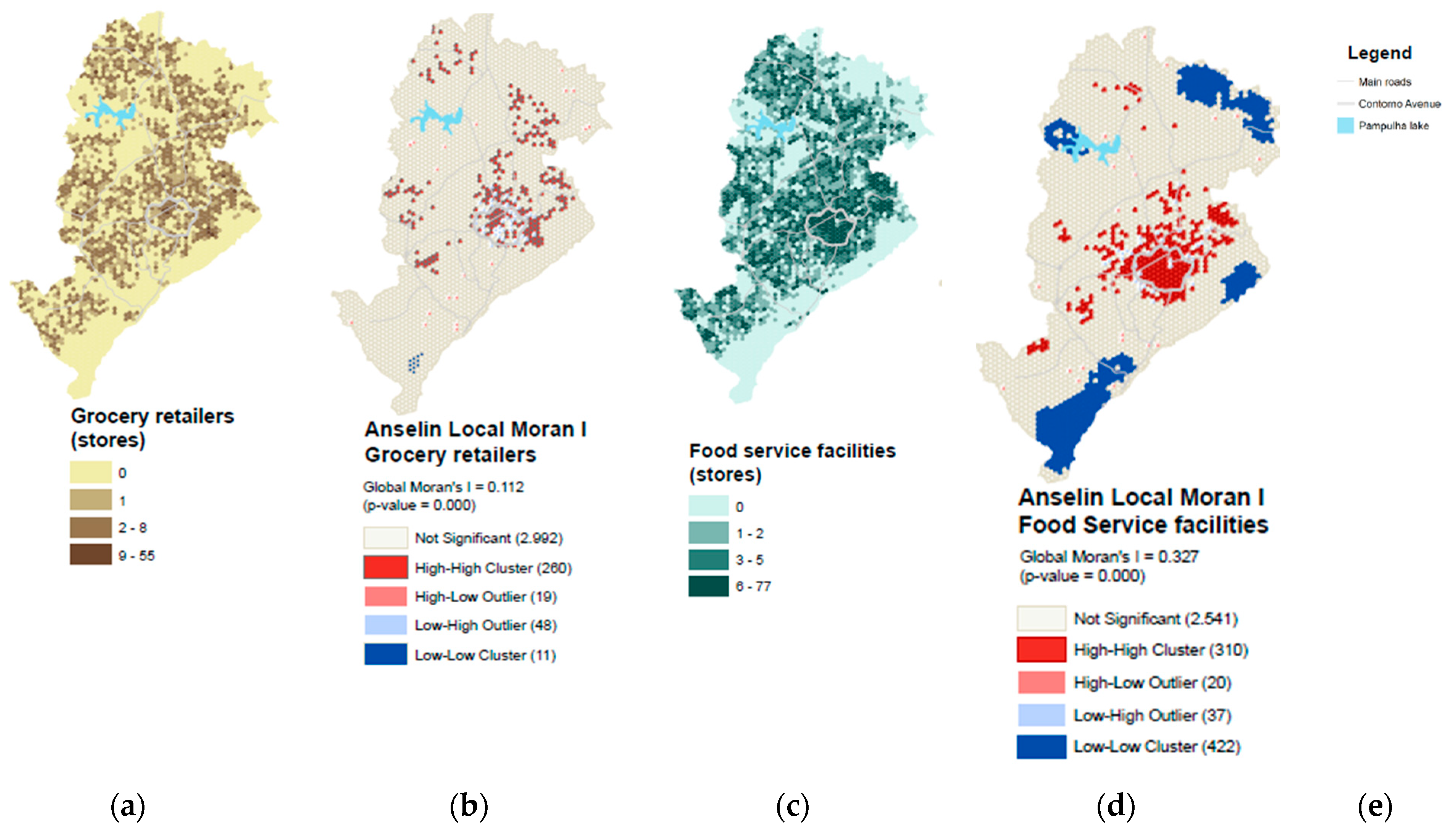
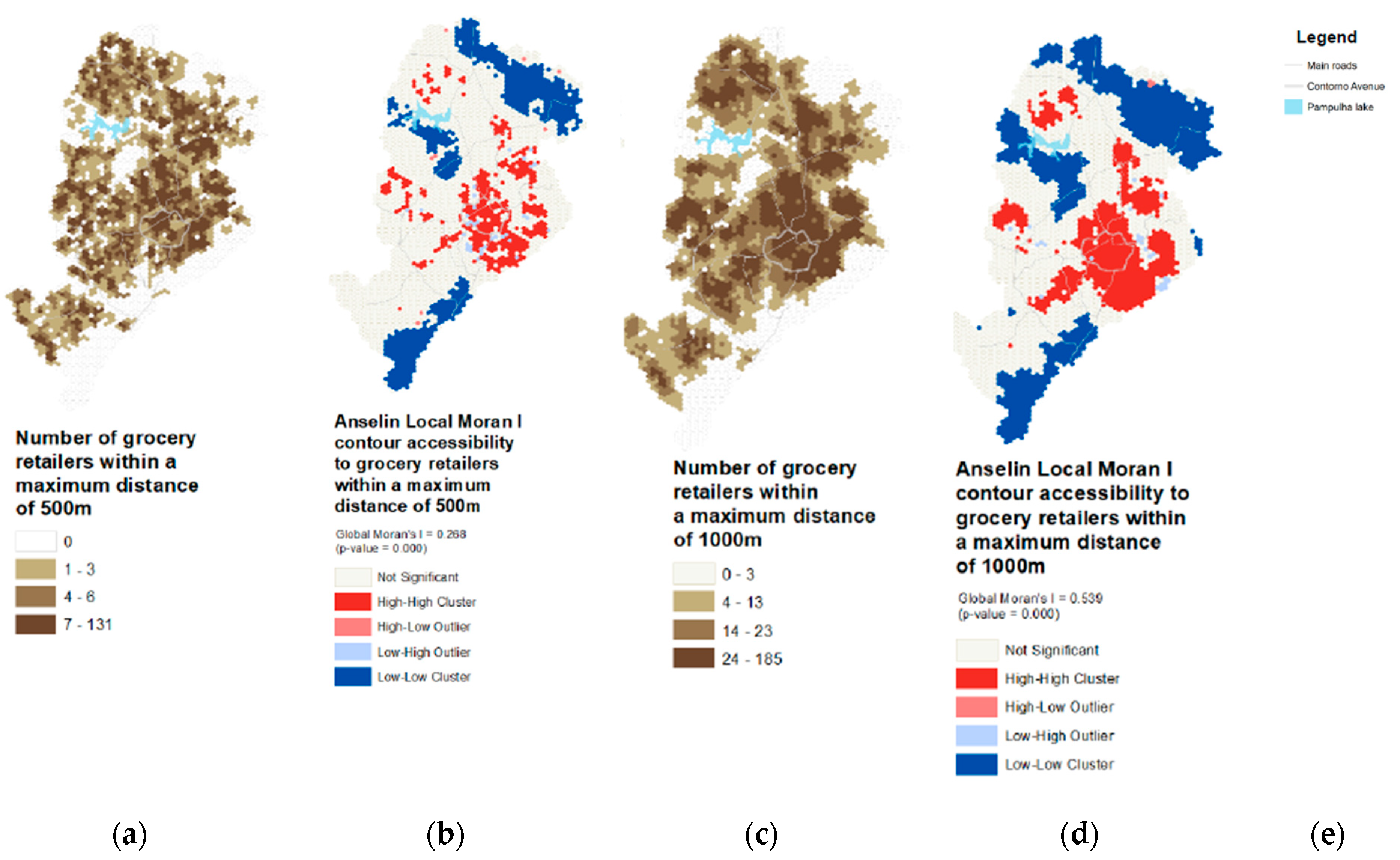
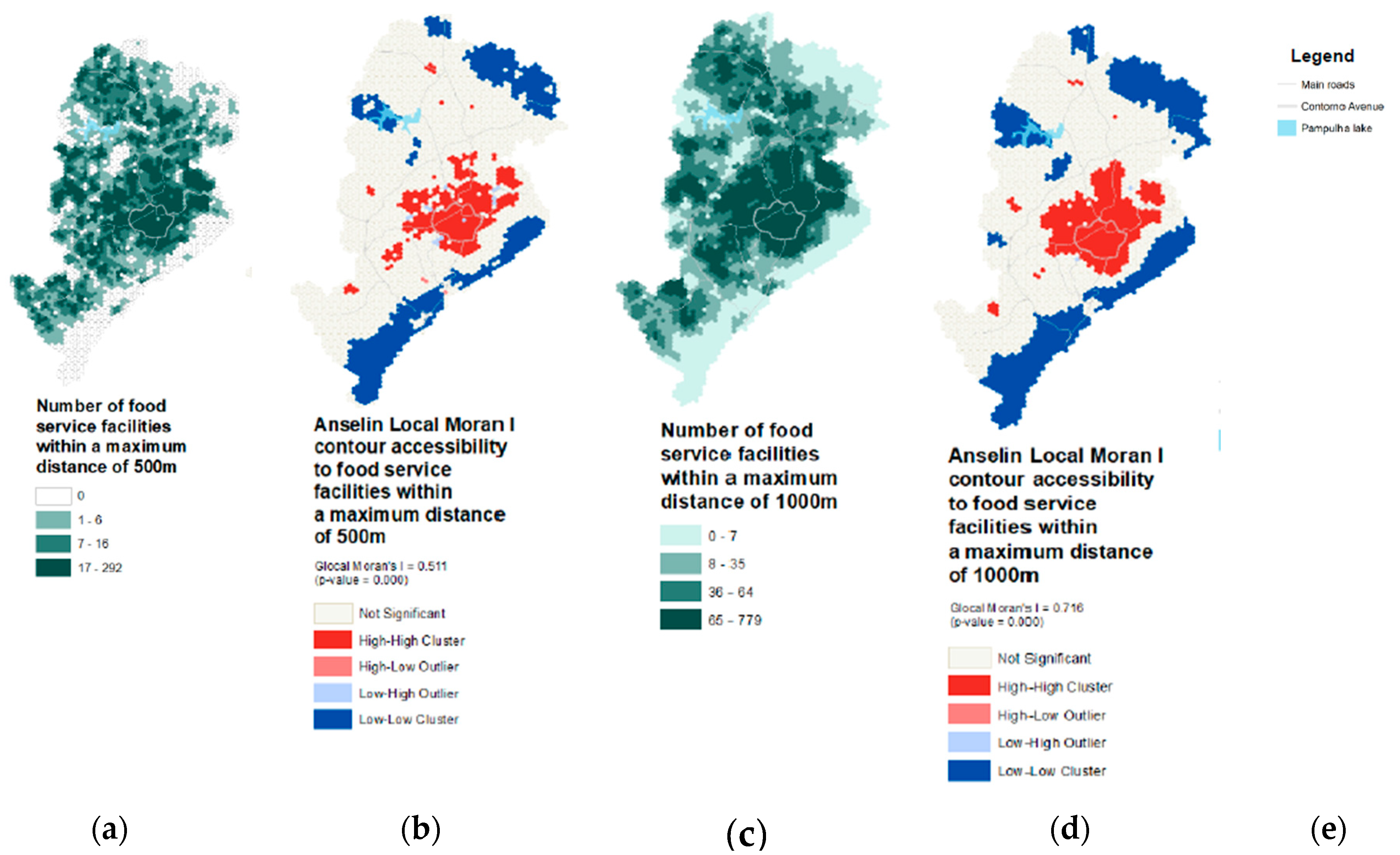
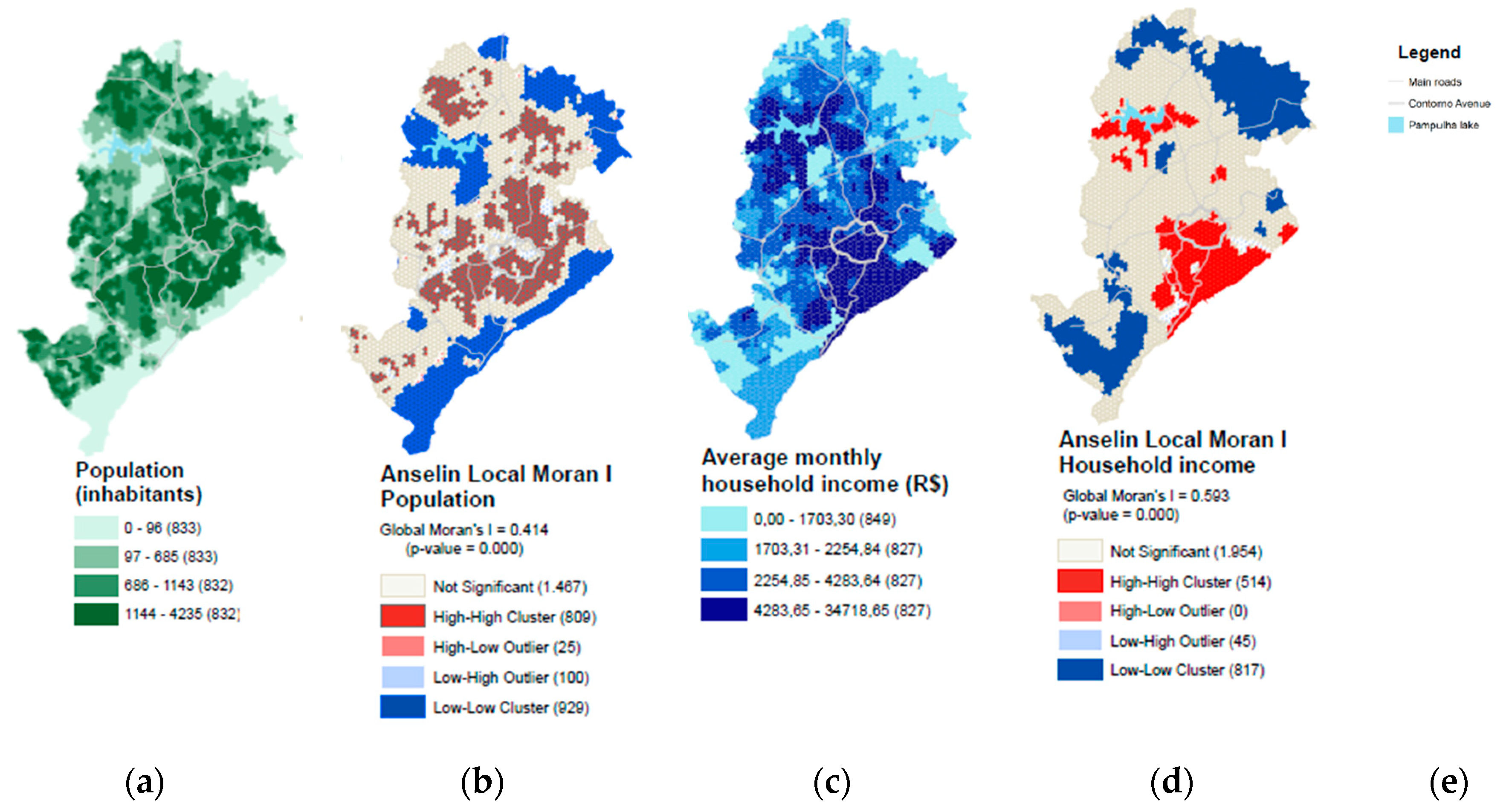
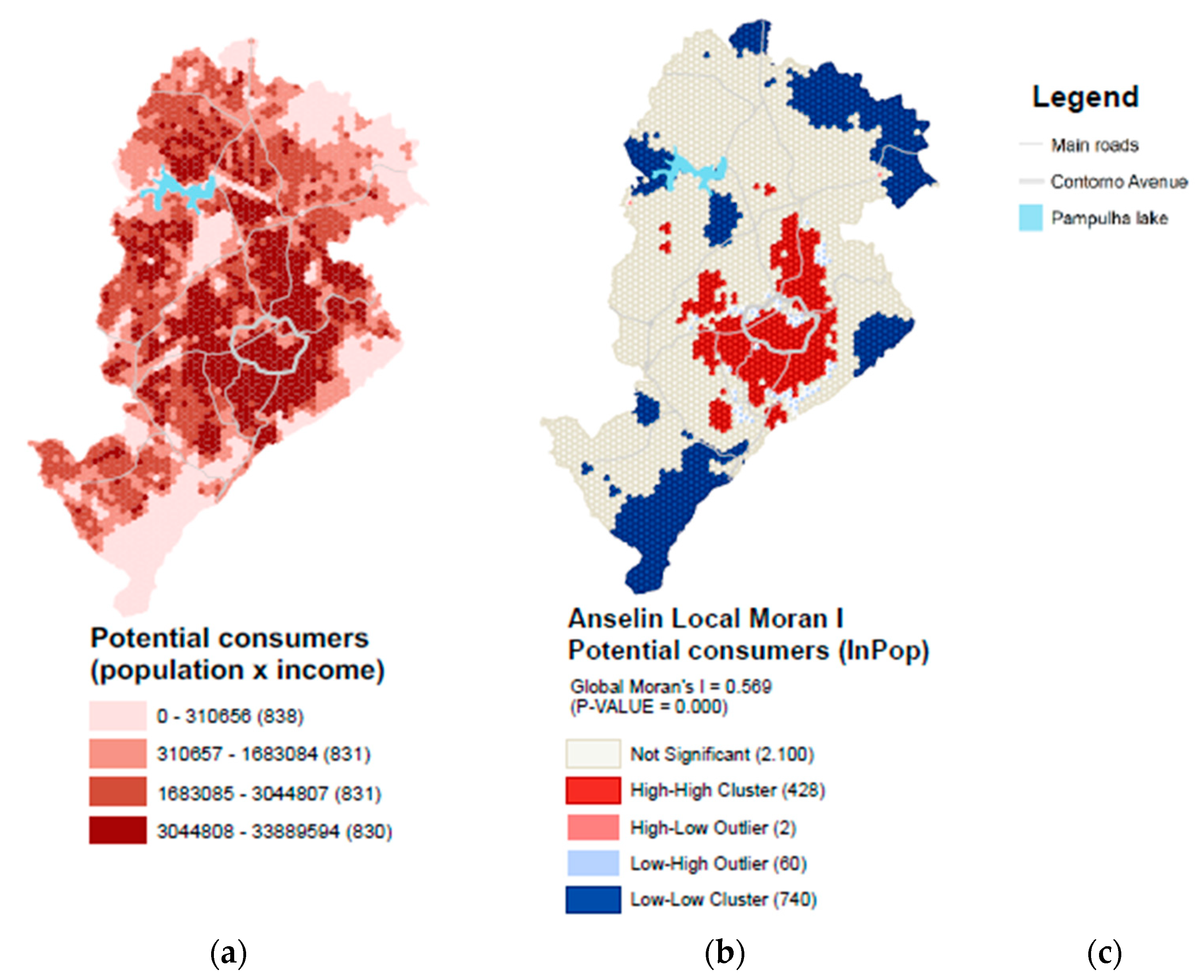
3. Results and Discussion

Given that we presented the data collection process and the description of attributes and variables in the previous section, we now reveal and discuss the spatial characterization and analysis of socioeconomic variables and the accessibility of food retailers to consumers.
The results concerning the spatial pattern of the retailers, computed through the method ANN, are presented in Table 1. It is essential to highlight that this is an exploratory analysis that takes into account the distance among points. This approach is related to the spatial pattern of the retailers and not to the propensity of consumers to access the nearest store. The only category that is not clustered within the Belo Horizonte territory is Hypermarkets, which present a dispersed spatial structure. These stores are designed for consolidated purchases and are mostly accessed by individual motorized modes. Therefore, we have excluded this category from the analysis of the Groceries group since we are evaluating the sustainable distribution of food, considering active purchase trips and home delivery. From Table 1, we can also notice that the availability of stores for the food service group is higher than that of grocery retailers.
In Figure 2, we present the choropleth and cluster maps for the location of grocery retailers (a,b) and food service facilities (c,d), respectively. We can understand from the stores’ concentration, that Belo Horizonte has concentrated urban functions in the Central Business District (CBD), which is the initially planned area of the city. Still, restaurants, snack bars, cafeterias and hotels are even more concentrated in this area. The CBD (within Contorno Avenue), Pampulha lake and the main roads of the city also are presented in the maps.
In Figure 3 and Figure 4 we present the choropleth and the cluster maps for the accessibility index determined for grocery retailers and food service facilities, respectively, considering both distance thresholds 500 m (a,b) and 1000 m (c,d). The choropleth maps were categorized in quartiles. For both categories, the Global Moran’s I index rises with the increase in the threshold adopted for the cumulative-opportunity measure, which was expected, since more establishments are computed for each distance limit. The areas where we find the clusters of low accessibility are similar for grocery retailers and food service facilities. These areas are located in the south and northeast of the municipality and on the surroundings of Pampulha lake (in blue). The CBD is strongly represented in the cluster analysis for both food retailers’ groups but, for grocery stores, there are other high accessibility clusters besides the central one, including the southeastern region of the city. This indicates that more areas of the urban area have better access to grocery goods compared to the access to Ho.Re.Ca food services.
In Figure 5, we present the choropleth and cluster maps for the population (a,b) and average monthly household income (c,d). The same representation is presented for the InPop index (Figure 6). There is only one region of the city where the high-income population is spatially concentrated, which includes the central area and expands to the southeastern boundary of the municipality. Belo Horizonte is a city that was originally planned within the area delimited by Contorno Avenue. The idealizers of the city imagined the urban growth could remain contained within the limits of this Avenue. Still, the urbanized area expanded to the borders of the county in the early stages of its development. Today, Belo Horizonte is a fully urbanized municipality. The cluster analysis (Anselin Local Moran I), as well as the Global Moran’s I index for population, income and InPop measure, indicate a spatially concentrated pattern with a strong relevance of the CBD.
To analyze the spatial mismatch, we have computed the proportion of population and respective income overlaying with the spatial structure of the food retailers, presented in (i) Figure 7 for the number of grocery retailers (a) and food service facilities (b); (ii) Figure 8 for the accessibility to food purchase opportunities for groceries with a 500 meter threshold (a) and a 1000 meter threshold (b) and (iii) Figure 9 for the accessibility to food services within 500 and 1000 m from the households (a,b).
From Figure 7a, income decreases with the increase in the number of grocery stores in each hexagon. For the upper quartile, there is only a little more than 1% of the population served and a small increase in the average income. However, this population still has a lower average income than the average of the city of Belo Horizonte. People with an average income superior than the one of the municipalities are concentrated in the lower quartile. This fact indicates that the wealthier the population, the more they count on motorized trips to receive or collect grocery goods.
When we consider the distribution of the population and respective income in the quartiles for the number of food service facilities (7b), there is also a concentration of the people in the first three classes. Though, there is an increase in the number of citizens located in bins within the upper quartile, representing slightly less than 5% of the city’s population. In this case, people with an average income above the municipality’s average is either concentrated in the first class or in the last one. This phenomenon highlights the cluster of Ho.Re.Ca establishments overlaying part of the high-income population, who have the most significant accessibility to ready-to-consume food.
If we consider the accessibility to grocery stores (Figure 8), the higher the income, the greater the accessibility. Still, the higher the spatial threshold considered, the greater the inequalities.
Considering the accessibility to food service facilities (Figure 9), the upper quartile presents the highest concentration of high-income people. Once again, this socioeconomic stratum is located, for both thresholds, in areas with the greatest and the least accessibility to food ready to be consumed.
Finally, concerning the last methodological step (sustainable last food mile opportunity), we spatially matched the clustered potential market for food purchasing through e-commerce channels (high InPop cluster) and the intersecting bins considering the accessibility levels. The overlaying area, composed of 430 hexagon bins, represents 25% of the city’s population with an average household monthly income almost twice the average of Belo Horizonte. The average distance to the closest retailer from each bin is less than 500 m, setting a walking distance for both categories of establishments. Additionally, the average number of stores within the 500 and 1000 meter thresholds from each centroid of the spatial units (hexagons) as origins are within the upper quartile of bins regarding the accessibility levels. The results, which are adequate for non-motorized delivery and pickup trips, are presented in Table 2. These results corroborate the spatial structure analysis, showing that Ho.Re.Ca stores are more concentrated in the CBD, where most of the overlaid bins are located. The spatial concentration of the high-income population is significant because it represents the most suitable potential market for food delivery services [14].

4. Conclusions

In this paper, we present an exploratory analysis of the accessibility of food systems in an important Brazilian city. The methodological approach proposed was designed to allow the analysis of the last-mile delivery of food to consumers regarding the transportation system and land use. The results indicate that there is a significant spatial concentration of food retailers in Belo Horizonte. This concentration is identified both in the spatial structure analysis and through the accessibility levels to food retailers. The areas with higher accessibility levels, in a comparative analysis, are mostly coincident with areas of clusters of high-income populations. Additionally, the food accessibility levels vary within the territory and might indicate that the locational decision for food retailers might have considered profitability issues. Nevertheless, with the growth in e-commerce as a food and grocery channel, the distance to consumers must be considered as impedance for retailers to perform their activity through this channel. Delivery and pickup of purchased food in stores need to be efficient both for the consumer and the retailer and should not increase the externalities of the urban freight distribution, such as congestion levels, emission of pollutants, etc. Considering this, public policy can be directed to land use regulation to stimulate more equity regarding access to food retailers and, therefore, more efficiency in the last mile and the participation of the consumer via active transportation modes in the last mile delivery.
Belo Horizonte presents some natural barriers: (i) Curral mountain range, in the southern fringe of the city; (ii) Pampulha lake, in the northwest and (iii) the confluence of the river basins Onça, Arruda and Velhas in the northeast. These areas are coincident with those of low accessibility clusters and, therefore, the land use policy should limit the occupation of these neighborhoods, despite the real estate speculation.
Even though sustainable mobility and efficiency have been the primary issues while planning urban distribution systems, accessibility is one approach that can help the development of sustainable and efficient food supply systems. We presented a methodological approach that combines the concept of accessibility considering land use and transportation issues and enhances the literature regarding food systems’ analysis, city logistics solutions and equity problems. Cumulative-opportunity measures to consumers from retailers can be a guideline towards public policy enhancement to promote non-motorized deliveries and crowd shipping. The introduction of the accessibility approach as a measure of equity and efficiency for the last mile to the food supply might result in suitable planning strategies for the food distribution, concerning the stakeholders’ different requirements. Additionally, this approach can subsidize the decision-making on urban structural elements, such as the land use regulation for food retailers with greater assertiveness and more spatial equality. To our knowledge, this kind of analysis has not yet been explored in the literature or in practical approaches for Latin America and, therefore, it brings a phenomenological contribution through the characterization of the food systems’ accessibility in Belo Horizonte.
Concerning further investigation, we suggest: (i) the enhancement of the accessibility analysis with other retail models and a more detailed impedance function; (ii) the inclusion of local consumption habits in the analysis and (iii) the analyses should also consider the assessment of the environmental, economic and social impacts of different levels of accessibility to food, including the evaluation of food deserts. Food deserts can be defined as areas where healthy food products are hard to be found [76]. Consumers’ preferences should then be related to the population characteristics and the access levels to the food retailing system. We understand the limitations of this work, based on the assumption that consumers will purchase food at the nearest store concerning the network travel distance. Nevertheless, delivery and purchase trips might be related to stores that are not located at the shortest distance but are accessible by trip-chaining along the daily commute. This issue should be further explored in future investigations.

Author Contributions

Conceptualization, R.L.M.d.O. and C.S.H.F.G.; methodology, R.L.M.d.O. and C.S.H.F.G.; software, R.L.M.d.O. and P.H.G.P.; validation, C.S.H.F.G.; formal analysis, R.L.M.d.O. and C.S.H.F.G.; writing—original draft preparation, R.L.M.d.O.; writing—review and editing, C.S.H.F.G. and P.H.G.P. All authors have read and agreed to the published version of the manuscript.

Funding

This research was funded by National Council for Scientific and Technological Development (CNPq) grant number 312750/2018-8.

Acknowledgments

This research was supported by the Federal Center for Technological Education of Minas Gerais (CEFET-MG), the National Council for Scientific and Technological Development (CNPq) and the National Council for the Improvement of Higher Education (CAPES). We also acknowledge the network data copyrighted by OpenStreetMap available from https://www.openstreetmap.org.

Conflicts of Interest

The authors declare no conflict of interest. The funders had no role in the design of the study; in the collection, analyses, or interpretation of data; in the writing of the manuscript, or in the decision to publish the results.

References

  1. United Nations. FAO—Food and Agriculture Organization of the United Nations. Available online: http://www.fao.org/home/en/ (accessed on 17 June 2015).
  2. United Nations. Global Sustainable Development Report; Department of Economic and Social Affairs: New York, NY, USA, 2016. [Google Scholar]
  3. Morganti, E.; Gonzalez-Feliu, J. City logistics for perishable products. The case of the Parma’s Food Hub. Case Stud. Transp. Policy 2015, 3, 120–128. [Google Scholar] [CrossRef]
  4. Oliveira, L.K.; Morganti, E.; Dablanc, L.; Oliveira, R.L.M. Analysis of the potential demand of automated delivery stations for e-commerce deliveries in Belo Horizonte, Brazil. Res. Transp. Econ. 2017, 65, 34–43. [Google Scholar] [CrossRef] [Green Version]
  5. Cui, J.Q.; Dodson, J.; Hall, P.V. Planning for Urban Freight Transport: An Overview. Transp. Rev. 2015, 35, 583–598. [Google Scholar] [CrossRef]
  6. González-Feliu, J. Urban logistics and spatial territorial intelligence indicators: State-of-the-art, typology and implications for Latin American cities. Interfases 2018, 011, 136–176. [Google Scholar] [CrossRef]
  7. Taniguchi, E.; Thompson, R.G.; Yamada, T.; van Duin, R. City Logistics: Network Modelling and Intelligent Transport Systems; Emerald Group Publishing Limited: Bingley, UK, 2001. [Google Scholar]
  8. Taniguchi, E. City logistics for sustainable and liveable cities. Green Logist. Transp. A Sustain. Supply Chain Perspect. 2015, 151, 49–60. [Google Scholar]
  9. Heitz, A.; Dablanc, L.; Olsson, J.; Sanchez-diaz, I.; Woxenius, J. Spatial patterns of logistics facilities in Gothenburg, Sweden. J. Transp. Geogr. 2018. Available online: https://www.sciencedirect.com/science/article/abs/pii/S0966692317305380 (accessed on 17 March 2020). [CrossRef]
  10. Gatta, V.; Marcucci, E.; Le Pira, M. Smart urban freight planning process: Integrating desk, living lab and modelling approaches in decision-making. Eur. Transp. Res. Rev. 2017, 9, 32. [Google Scholar] [CrossRef] [Green Version]
  11. Browne, M.; Allen, J.; Nemoto, T.; Patier, D.; Visser, J. Reducing Social and Environmental Impacts of Urban Freight Transport: A Review of Some Major Cities. Procedia Soc. Behav. Sci. 2012, 39, 19–33. [Google Scholar] [CrossRef]
  12. Vierth, I.; Mellin, A.; Karlsson, J.; Karlsson, R.; Johansson, M.; Thompson, R.G.; Wild, D.; Holguin-Veras, J.; Studies, P.T.; Rodrigue, J.-P.; et al. Towards a Land-use and Transport interaction Framework. Transp. Res. Rec. J. Transp. Res. Board 2012, 2269, 1–5. [Google Scholar]
  13. Vieira, J.G.V.; Fransoo, J.C.; Carvalho, C.D. Freight distribution in megacities: Perspectives of shippers, logistics service providers and carriers. J. Transp. Geogr. 2015, 46, 46–54. [Google Scholar] [CrossRef]
  14. Pigatto, G.; Machado, J.G.; Negreti, A.; Machado, L. Have you chosen your request? Analysis of online food delivery companies in Brazil. Manag. Res. Rev. 2017, 40, 352–367. [Google Scholar] [CrossRef]
  15. Herzog, B.O. Urban Freight in Developing Cities Module 1g Sustainable Transport: A Sourcebook for Policy-Makers in Developing Cities; GTZ: Eschborn, Germany, 2009. [Google Scholar]
  16. O’Brien, T.; Giuliano, G.; Dablanc, L.; Holliday, K. Synthesis of Freight Research in Urban. Transportation Planning; Transportation Research Board: Washington, DC, USA, 2016; ISBN 978-0-309-25908-8. [Google Scholar]
  17. Morganti, E. Urban Food Planning, City Logistics and Sustainability: The Role of the Wholesale Produce Market. The Cases of Parma and Bologna Food Hubs. Ph.D. Thesis, Université de Bologne, Bologna, Italy, 2011. [Google Scholar]
  18. Rodrigue, J.-P.; Comtois, C.; Slack, B. The Geography of Transport Systems; Routledge: London, UK, 2006. [Google Scholar]
  19. Morganti, E. Urban food planning and transport sustainability: A case study in Parma, Italy. 2011. Available online: https://halshs.archives-ouvertes.fr/halshs-00907815/ (accessed on 17 March 2020).
  20. Lopes, A.S.; Loureiro, C.F.G.; Van Wee, B. LUTI operational models review based on the proposition of an a priori ALUTI conceptual model. Transp. Rev. 2019, 39, 204–225. [Google Scholar] [CrossRef] [Green Version]
  21. Macário, R. Access as a social good and as an economic good: Is there a need of paradigm shift. In Urban Access for the 21 st Century, Finance and Governance Models for Transport Infrastructures; Sclar, E.D., Lönnroth, M., Wolmar, C., Eds.; Taylor & Francis: New York, NY, USA, 2014; pp. 87–115. [Google Scholar]
  22. Banister, D. The sustainable mobility paradigm. Transp. Policy 2008, 15, 73–80. [Google Scholar] [CrossRef]
  23. Gonzalez-Feliu, J.; Peris-Pla, C. Impacts of retailing attractiveness on freight and shopping trip attraction rates. Res. Transp. Bus. Manag. 2017, 24, 49–58. [Google Scholar] [CrossRef]
  24. Gardrat, M.; Serouge, M.; Toilier, F.; Gonzalez-Feliu, J. Simulating the Structure and Localization of Activities for Decision Making and Freight Modelling: The SIMETAB Model. Procedia Soc. Behav. Sci. 2014, 125, 147–158. [Google Scholar] [CrossRef] [Green Version]
  25. Gonzalez-Feliu, J.; Salanova Grau, J.M.; Beziat, A. A location-based accessibility analysis to estimate the suitability of urban consolidation facilities. Int. J. Urban Sci. 2014, 18, 166–185. [Google Scholar] [CrossRef]
  26. Giuliano, G.; Kang, S.; Yuan, Q. Spatial Dynamics of the Logistics Industry and Implications for Freight Flows; UC Davis: National Center for Sustainable Transportation, 2016; Available online: https://escholarship.org/uc/item/94h6t7s9 (accessed on 17 March 2020).
  27. Giuliano, G.; Kang, S. Spatial dynamics of the logistics industry: Evidence from California. J. Transp. Geogr. 2018, 66, 248–258. [Google Scholar] [CrossRef]
  28. Holguín-Veras, J.; Ramírez-Ríos, D.G.; Encarnación, T.; Gonzalez-Feliu, J.; Caspersen, E.; Rivera-González, C.; Gonzalez-Calderon, C.A.; Lima, R.d.S. Metropolitan Economies and the Generation of Freight and Service Activity: An International Perspective. In Urban Logistics: Management, Policy and Innovation in a Rapidly Changing Environment; Browne, M., Behrends, S., Woxenius, J., Giuliano, G., Holguín-Veras, J., Eds.; Kogan Page Publishers: London, UK, 2018; p. 392. [Google Scholar]
  29. van Wee, B. Accessible accessibility research challenges. J. Transp. Geogr. 2016, 51, 9–16. [Google Scholar] [CrossRef]
  30. Lin, L.; Han, H.; Yan, W.; Nakayama, S.; Shu, X. Measuring Spatial Accessibility to Pick-Up Service Considering Differentiated Supply and Demand: A Case in Hangzhou, China. Sustainability. 2019, 11, 3448. [Google Scholar] [CrossRef] [Green Version]
  31. Geurs, K.T.; van Wee, B. Accessibility evaluation of land-use and transport strategies: Review and research directions. J. Transp. Geogr. 2004, 12, 127–140. [Google Scholar] [CrossRef]
  32. Garcia, C.S.H.F.; Macário, M.d.R.M.R.; Menezes, E.D.d.A.G.; Loureiro, C.F.G. Strategic Assessment of Lisbon’s Accessibility and Mobility Problems from an Equity Perspective. Netw. Spat. Econ. 2018, 18, 415–439. [Google Scholar] [CrossRef]
  33. Hansen, W.G. How Accessibility Shapes Land Use. J. Am. Plan. Assoc. 1959, 25, 73–76. [Google Scholar] [CrossRef]
  34. Boisjoly, G.; El-Geneidy, A.M. How to get there? A critical assessment of accessibility objectives and indicators in metropolitan transportation plans. Transp. Policy 2017, 55, 38–50. [Google Scholar] [CrossRef]
  35. Pereira, R.H.M.; Banister, D.; Schwanen, T.; Wessel, N. Distributional effects of transport policies on inequalities in access to opportunities in Rio de Janeiro. J. Transp. Land Use 2019, 12, 741–764. [Google Scholar] [CrossRef] [Green Version]
  36. Widener, M.J.; Minaker, L.; Farber, S.; Allen, J.; Vitali, B.; Coleman, P.C.; Cook, B. How do changes in the daily food and transportation environments affect grocery store accessibility? Appl. Geogr. 2017, 83, 46–62. [Google Scholar] [CrossRef]
  37. Crush, J.; Frayne, B. Supermarket expansion and the informal food economy in Southern African cities: Implications for urban food security. J. S. Afr. Stud. 2011, 37, 781–802. [Google Scholar] [CrossRef]
  38. Fancello, G.; Paddeu, D.; Fadda, P. Investigating last food mile deliveries: A case study approach to identify needs of food delivery demand. Res. Transp. Econ. 2017, 65, 56–66. [Google Scholar] [CrossRef]
  39. Paddeu, D.; Fadda, P.; Fancello, G.; Parkhurst, G.; Ricci, M. Reduced Urban traffic and emissions within Urban consolidation centre schemes: The case of Bristol. Transp. Res. Procedia 2014, 3, 508–517. [Google Scholar]
  40. Gonzalez-Feliu, J.; Peris-Pla, C. Impacts of retailing land use on both retailing deliveries and shopping trips: Modelling framework and decision support system. IFAC-PapersOnLine 2018, 51, 606–611. [Google Scholar] [CrossRef]
  41. Marcucci, E.; Gatta, V. Investigating the potential for off-hour deliveries in the city of Rome: Retailers’ perceptions and stated reactions. Transp. Res. Part A Policy Pract. 2017, 102, 142–156. [Google Scholar] [CrossRef]
  42. Morganti, E.; Seidel, S.; Blanquart, C.; Dablanc, L.; Lenz, B. The Impact of E-commerce on Final Deliveries: Alternative Parcel Delivery Services in France and Germany. Transp. Res. Procedia 2014, 4, 178–190. [Google Scholar] [CrossRef] [Green Version]
  43. Bjørgen, A.; Bjerkan, K.Y.; Hjelkrem, O.A. E-groceries: Sustainable last mile distribution in city planning. 2019. Available online: https://www.sciencedirect.com/science/article/pii/S0739885919303294 (accessed on 17 March 2020).
  44. Saskia, S.; Mareï, N.; Blanquart, C. Innovations in e-grocery and Logistics Solutions for Cities. Transp. Res. Procedia 2016, 12, 825–835. [Google Scholar] [CrossRef]
  45. Mkansi, M.; Nsakanda, A.L. Leveraging the physical network of stores in e-grocery order fulfilment for sustainable competitive advantage. 2019. Available online: https://www.sciencedirect.com/science/article/pii/S0739885919303026 (accessed on 17 March 2020).
  46. Aljohani, K.; Thompson, R.G. The impacts of relocating a logistics facility on last food miles – The case of Melbourne’s fruit & vegetable wholesale market. Case Stud. Transp. Policy 2018, 6, 279–288. [Google Scholar]
  47. Tong, D.; Ren, F.; Mack, J. Locating farmers’ markets with an incorporation of spatio-temporal variation. Socioecon. Plann. Sci. 2012, 46, 149–156. [Google Scholar] [CrossRef]
  48. Zhang, H.; Xiong, Y.; He, M.; Qu, C. Location Model for Distribution Centers for Fulfilling Electronic Orders of Fresh Foods under Uncertain Demand. 2017. Available online: https://www.hindawi.com/journals/sp/2017/3423562/ (accessed on 17 March 2020).
  49. Durand, B.; Gonzalez-Feliu, J. Urban Logistics and E-Grocery: Have Proximity Delivery Services a Positive Impact on Shopping Trips? Procedia - Soc. Behav. Sci. 2012, 39, 510–520. [Google Scholar] [CrossRef]
  50. Cagliano, A.C.; Gobbato, L.; Tadei, R.; Perboli, G. ITS for e-grocery business: The simulation and optimization of Urban logistics project. Transp. Res. Procedia 2014, 3, 489–498. [Google Scholar] [CrossRef] [Green Version]
  51. Belo Horizonte, C.H. Statistics and Indicators. Dashboard. 2017. Available online: https://prefeitura.pbh.gov.br/estatisticas-e-indicadores (accessed on 10 March 2018).
  52. Belo Horizonte, C.H. Municipal Register of Contributors. 2017. Available online: http://portalpbh.pbh.gov.br/pbh/ecp/comunidade.do?evento=portlet&pIdPlc=ecpTaxonomiaMenuPortal&app=cmc&tax=29098&lang=pt_BR&pg=6020&taxp=0& (accessed on 10 May 2018).
  53. IBGE—Brazilian Institute for Geography and Statistics. Demographic Census 2010; IBGE: Rio de Janeiro, Spain, 2011. Available online: http://www.ibge.gov.br/home/estatistica/populacao/censo2010/caracteristicas_da_populacao/resultados_do_universo.pdf (accessed on 1 July 2013).
  54. OpenStreetMap contributors Belo Horizonte street network. Available online: https://www.openstreetmap.org (accessed on 1 January 2018).
  55. Kedia, A.; Kusumastuti, D.; Nicholson, A. Establishing collection and delivery points to encourage the use of active transport: A case study in New Zealand using a consumer-centric approach. Sustainability 2019, 11, 6255. [Google Scholar] [CrossRef] [Green Version]
  56. Oliveira, L.K.; Oliveira, R.L.M.; De Sousa, L.T.M.; De Paula Caliari, I.; De Oliveira Leite Nascimento, C. Analysis of accessibility from collection and delivery points: Towards the sustainability of the e-commerce delivery. Urbe 2019, 11, 1–17. [Google Scholar] [CrossRef] [Green Version]
  57. Garber, N.J.; Hoel, L.A. Traffic and Highway Engineering; CL Engineering: Toronto, ON, Canada, 2014. [Google Scholar]
  58. Ryeng, E.O.; Haugen, T.; Grønlund, H.; Overå, S.B. Evaluating Bluetooth and Wi-Fi Sensors as a Tool for Collecting Bicycle Speed at Varying Gradients. Transp. Res. Procedia 2016, 14, 2289–2296. [Google Scholar] [CrossRef] [Green Version]
  59. Dijkstra, E.W. A note on two problems in connexion with graphs. Math 1959, 1, 269–271. Available online: https://www.cs.yale.edu/homes/lans/readings/routing/dijkstra-routing-1959.pdf (accessed on 17 March 2020). [CrossRef] [Green Version]
  60. Kai, N.; Yao-ting, Z.; Yue-peng, M. Shortest Path Analysis Based on Dijkstra’s Algorithm in Emergency Response System. Telkomnika Indones. J. Electr. Eng. 2014, 12, 3476–3482. [Google Scholar] [CrossRef]
  61. Aziz, S.; Ngui, R.; Lim, Y.A.L.; Sholehah, I.; Nur Farhana, J.; Azizan, A.S.; Wan Yusoff, W.S. Spatial pattern of 2009 dengue distribution in Kuala Lumpur using GIS application. Trop. Biomed. 2012, 29, 113–120. [Google Scholar] [PubMed]
  62. Longley, P.; Iba, W. Average-Case Analysis of a Nearest Neighbor Algorithm. In Proceedings of the Thirteenth International Joint Conference on Artificial Intelligence, Chambéry, France, 28 August–3 September 1993. [Google Scholar]
  63. Krause, E.F. Taxicab geometry; Dover and Addison-Wesley Publishing Company: Menlo Park, CA, USA, 1986; ISBN 978-0-486-25202-5. [Google Scholar]
  64. Longley, P.A.; Goodchild, M.F.; Maguire, D.J.; Rhind, D.W. Geographical Information Systems and Science; John Wiley & Sons: Hoboken, NJ, USA, 2011; Volume 83, ISBN 0470870001. [Google Scholar]
  65. Manolopoulos, Y.; Papadopoulos, A.N.; Vassilakopoulos, M.G. Spatial Databases: Technologies, Techniques and Trends; IGI Global: Hershey, PA, USA, 2005; ISBN 1591403898. [Google Scholar]
  66. Anselin, L.; Syabri, I.; Kho, Y. An Introduction to Spatial Data Analysis. Geogr. Anal. 2006, 38, 5–22. [Google Scholar] [CrossRef]
  67. Anselin, L. Under the hood Issues in the specification and interpretation of spatial regression models. Agric. Econ. 2002, 27, 247–267. [Google Scholar] [CrossRef]
  68. Anson, R.W.; Ormeling, F.J. Basic Cartography: For Students and Technicians, Exercise Manual; Elsevier: London, UK, 2013; ISBN 9781483257129. [Google Scholar]
  69. Melecky, L. Spatial Autocorrelation Method for Local Analysis of The EU. Procedia Econ. Financ. 2015, 23, 1102–1109. [Google Scholar] [CrossRef] [Green Version]
  70. Moran, B.Y.P.A.P. Notes on Continuous Stochastic Phenomena. Available online: https://academic.oup.com/biomet/article-abstract/37/1-2/17/194868?redirectedFrom=fulltext (accessed on 17 March 2020).
  71. Banerjee, A.; Singh, A.K.; Chaurasia, H. An exploratory spatial analysis of low birth weight and its determinants in India. 2020. Available online: https://www.sciencedirect.com/science/article/abs/pii/S2213398420300142 (accessed on 17 March 2020).
  72. Anselin, L.; Anselin, L. Exploring Spatial Data with GeoDa. Geography. 2005. Available online: http://www.csiss.org/clearinghouse/GeoDa/geodaworkbook.pdf (accessed on 17 March 2020).
  73. Tepanosyan, G.; Sahakyan, L.; Zhang, C.; Saghatelyan, A. The application of Local Moran’s I to identify spatial clusters and hot spots of Pb, Mo and Ti in urban soils of Yerevan. Appl. Geochemistry 2019, 104, 116–123. [Google Scholar] [CrossRef]
  74. Zhang, C.; Luo, L.; Xu, W.; Ledwith, V. Use of local Moran’s I and GIS to identify pollution hotspots of Pb in urban soils of Galway, Ireland. Sci. Total Environ. 2008, 398, 212–221. [Google Scholar] [CrossRef]
  75. Guo, L.; Ma, Z.; Zhang, L. Comparison of bandwidth selection in application of geographically weighted regression: A case study. Can. J. For. Res. 2008, 38, 2526–2534. [Google Scholar] [CrossRef]
  76. Dutko, P.; Ver Ploeg, M.; Farrigan, T. Characteristics and Influentialfactors of Food Deserts. Available online: https://ageconsearch.umn.edu/record/262229/ (accessed on 17 March 2020).
Figure 1. Methodological approach.
Sustainability 12 02654 g001
Figure 2. Choropleth map and spatial cluster analysis for grocery retailers (a,b); and food service facilities (c,d). (e): Legend.
Sustainability 12 02654 g002
Figure 3. Cumulative-opportunity measure (choropleth and cluster maps) for grocery retailers: (a,b) 500 meter-threshold; and (c,d) 1000 meter-threshold. (e): Legend.
Sustainability 12 02654 g003
Figure 4. Cumulative-opportunity measure (choropleth and cluster maps) for food service facilities: (a,b) 500 meter-threshold; and (c,d) 1000 meter-threshold. (e): Legend.
Sustainability 12 02654 g004
Figure 5. Choropleth map and spatial cluster analysis for: population (a,b); and income (c,d). (e): Legend.
Sustainability 12 02654 g005
Figure 6. (a) Choropleth map and (b) spatial cluster analysis for the InPop index. (c): Legend.
Sustainability 12 02654 g006
Figure 7. Spatial mismatch considering the frequency of (a) grocery retailers and (b) food service facilities.
Sustainability 12 02654 g007
Figure 8. Spatial mismatch considering the accessibility to grocery retailers (a) within 500 m and (b) 1000 m.
Sustainability 12 02654 g008
Figure 9. Spatial mismatch considering the accessibility to food service facilities (a) within 500 m and (b) 1000 m.
Sustainability 12 02654 g009
Table 1. Categories and Spatial Structure for Food Retailers in Belo Horizonte.
GroupCategoryNumber of RetailersStores Density (Stores/km2)Number of Stores per Capita (Stores/1000 Inhabitants)Spatial Patternp-Value
Food ServiceRestaurants423112.81.7Clustered0
Cafes and bars582217.62.3Clustered0
Bakeries12323.70.5Clustered0
GroceriesLocal markets21116.40.8Clustered0
Supermarkets3721.10.1Clustered0
Hypermarkets230.10.009Dispersed0.000057
Fresh food11313.40.5Clustered0
Table 2. Attributes to analyze suitable areas for non-motorized deliveries and purchase trips for food retailers in Belo Horizonte.
AttributeGrocery RetailersFood Service Facilities
Population (% out of municipality)599,217 (25%)
Income (4.50 Brazilian real ~ 1 US$)7274.08
Average distance to the closest facility from each hexagon (m) 263147
Maximum distance to the closest facility from each hexagon (m)14831071
The average number of facilities within a 500-meter threshold from each hexagon6.5787.75
The average number of facilities within a 1000-meter threshold from each hexagon28.44114.07

