Benefit Distribution of Community-Based Infrastructure: Agricultural Roads in Indonesia

Abstract
1. Introduction
2. Materials and Methods
Time-Saving
Cost Reduction
Diversification
Added Value
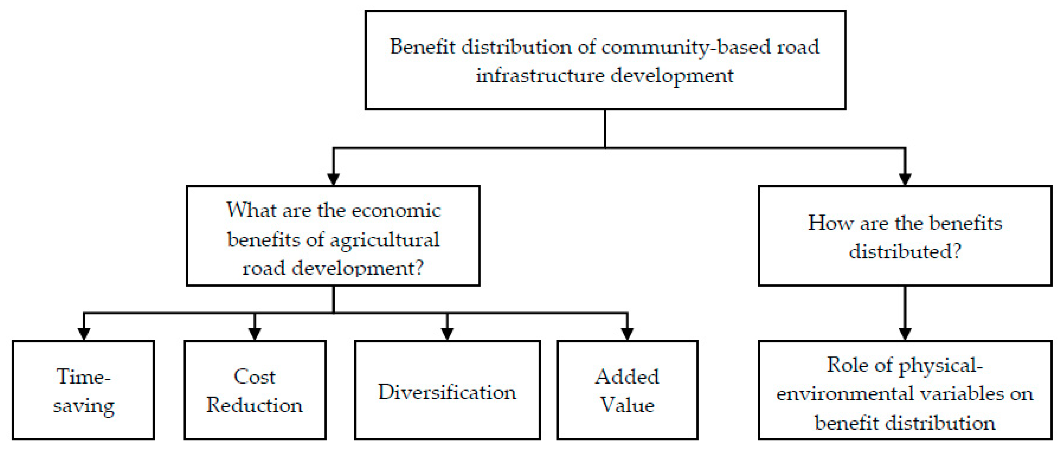
3. Results
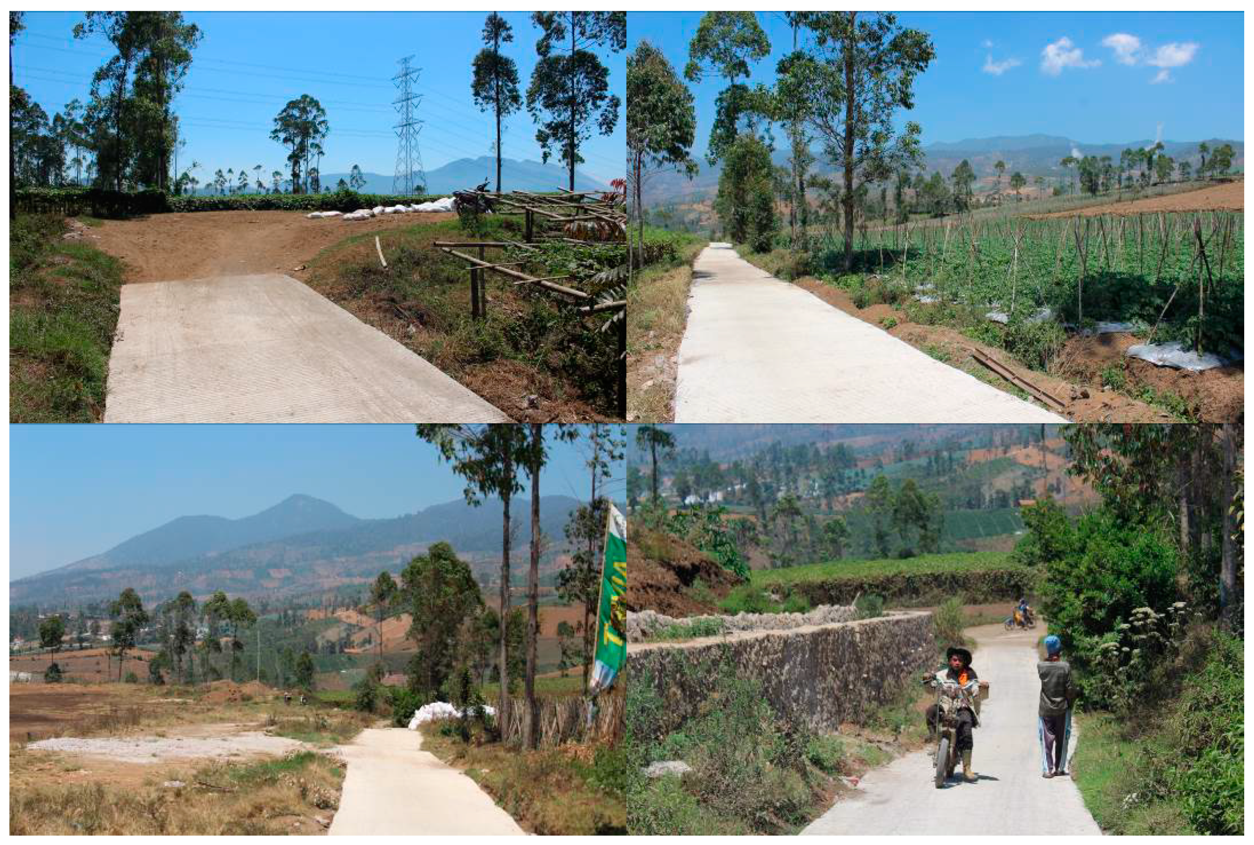
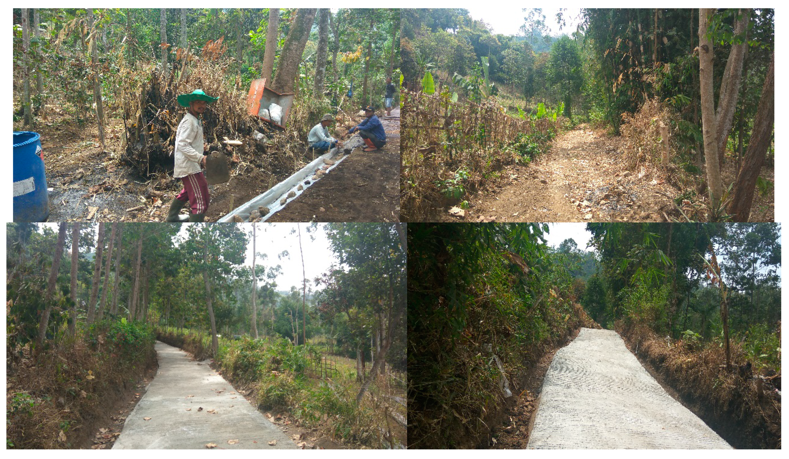
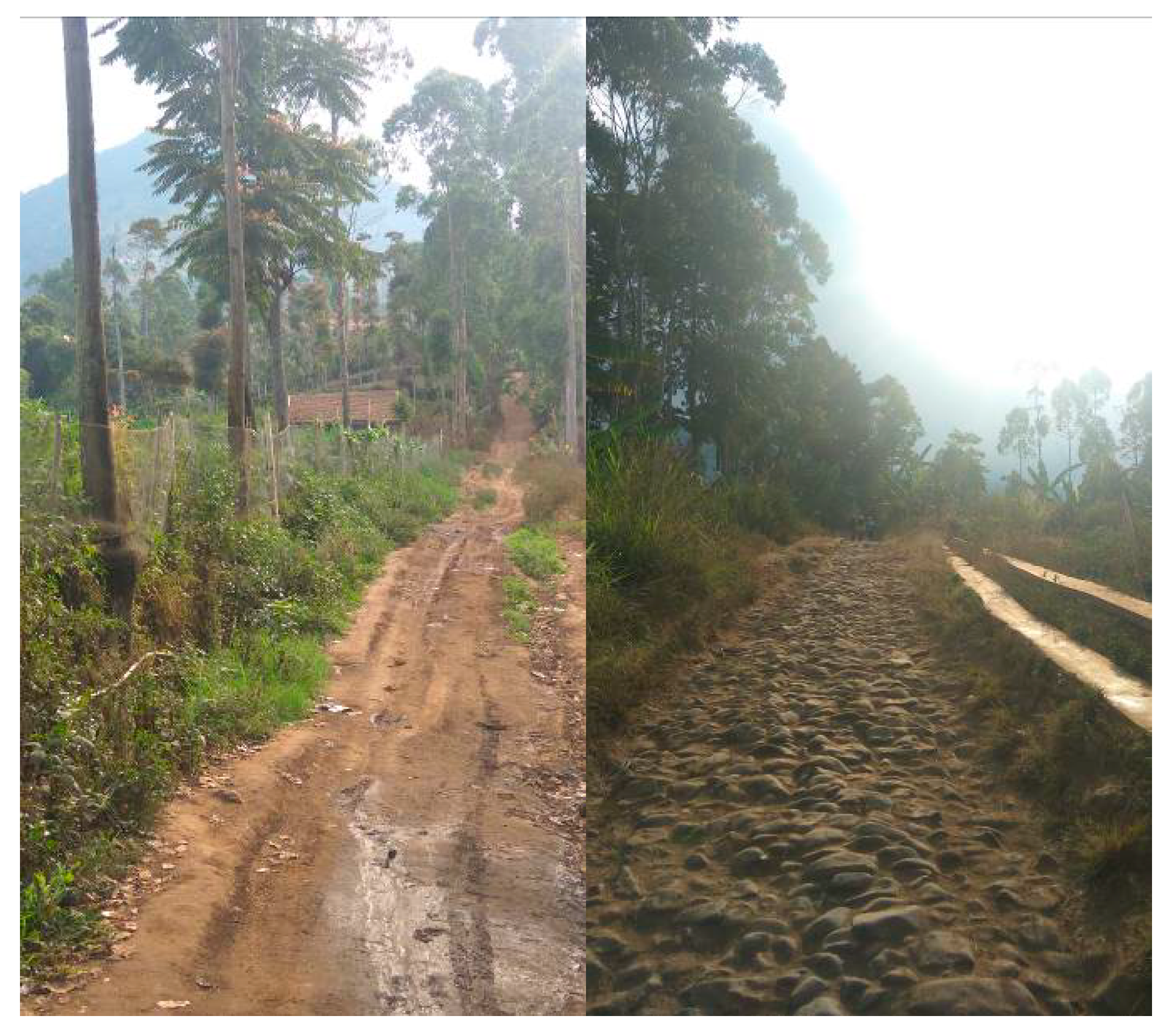
3.1. Overview of the Cases
3.1.1. Padaawas Village
3.1.2. Bayongbong Village
3.1.3. Panjiwangi Village
3.1.4. Pamulihan Village
3.2. Benefits of Agricultural Road Development
3.2.1. Padaawas Village
3.2.2. Bayongbong Village
3.2.3. Panjiwangi Village
3.2.4. Pamulihan Village
3.3. Benefit Distribution of Agricultural Road Development
4. Discussion
5. Conclusions
Author Contributions
Funding
Acknowledgments
Conflicts of Interest
Appendix A

| No | Information Needed | Questions | Interviewees |
|---|---|---|---|
| 1 | The role of local government in developing agricultural road | • How is the implementation of the agricultural road development plan? | Garut District Agriculture Agency, Garut District Development and Planning Agency, and Garut District Trade and Commerce Agency |
| • What are the roles of the local government in agricultural road development? | |||
| • What are the roles of the local government in agricultural road operation, maintenance, and rehabilitation? | |||
| • What are the roles of the local government in the improvement of agricultural roads? | |||
| 2 | The role of farmer groups in developing agricultural road | • How many farmers, landowners, and smallholders in the Farmer Group? | The Head of Farmer Group |
| • What are the roles of farmer group in agricultural road development? | |||
| • What are the roles of farmer group in agricultural road rehabilitation? | |||
| • What are the roles of farmer group in the improvement of agricultural road? | |||
| • What are the roles of farmer group in agricultural road maintenance? | |||
| • What are the roles of farmer group in agricultural road funding? | |||
| • What are the problems found in road development? | |||
| • How is the marketing mechanism of agricultural products? | |||
| 3 | Impacts of agricultural road | • How is the distance between farmland and agricultural road? | Farmers |
| • How far is the distance from farmland to the • ion point before and after road construction? | |||
| • How much time is needed to transport the crops from farmland to the collection point before and after road construction? | |||
| • How is the frequency of transporting crops from farmland to the collection point before and after road construction? | |||
| • How much is the cost of transporting crops from farmland to the collection point before and after road construction? What kind of costs? | |||
| • What kind of commodities planted in the farmland before and after road construction? | |||
| • Do the farmers implement intercropping system before and after road construction? | |||
| • Do the farmers enhance the value of crops before and after road construction? What are the kinds of enhancements? | |||
| • How much are the wages for labor or porter? | |||
| • Do the farmers feel that benefits are equally distributed? | |||
| • What are the preferences of the farmers for the future concerning road development? | |||
| • What are the benefits perceived from agricultural road development? | |||
| • What problems arise from agricultural road development? |
References
- Government of Indonesia (GoI). Undang-Undang No. 22 Tahun 2009 Tentang Lalu Lintas dan Angkutan Jalan [Law No. 22 of 2009 Concerning Road Traffic and Transportation]; Government of Indonesia (GoI): Jakarta, Indonesia, 2009.
- Ministry of Agriculture Republic of Indonesia. Technical Guidelines for the Development of Agricultural Roads; Ministry of Agriculture Republic of Indonesia: Jakarta, Indonesia, 2013.
- Bertolini, P. Overview of Income and Non-Income Rural Poverty in Developed Countries. In Proceedings of the Expert Group Meeting on Eradicating Rural Poverty to Implement the 2030 Agenda for Sustainable Development, United Nations Economic Commission for Africa, Addis Ababa, Ethiopia, 27 February–1 March 2019. [Google Scholar]
- World Bank. Poverty and Shared Prosperity 2018: Piecing Together the Poverty Puzzle; World Bank: Washington, DC, USA, 2018; Available online: https://openknowledge.worldbank.org/handle/10986/30418 (accessed on 15 October 2019).
- World Bank. Indonesia: Boosting Rural Government Capacity, Infrastructure, and Citizen Engagement to Accelerate Poverty Reduction; World Bank: Washington, DC, USA, 2019; Available online: https://www.worldbank.org/en/news/press-release/2019/06/26/indonesia-boosting-rural-government-capacity-infrastructure-and-citizen-engagement-to-accelerate-poverty-reduction (accessed on 15 October 2019).
- Aji, P. Summary of Indonesia’s Poverty Analysis. In ADB Papers on Indonesia; Asian Development Bank: Jakarta, Indonesia, 2015; p. 4. [Google Scholar]
- International Labour Organization (ILO). Infrastructure, Poverty Reduction and Jobs; International Labour Organization (ILO): Geneva, Switzerland, 2019; Available online: https://www.ilo.org/global/docs/WCMS_099513/lang--en/index.htm (accessed on 15 October 2019).
- Javid, M. Public and Private Infrastructure Investment and Economic Growth in Pakistan: An Aggregate and Disaggregate Analysis. Sustain. J. 2019, 11, 3359. [Google Scholar] [CrossRef]
- Lenz, N.V.; Skender, H.P.; Mirković, P.A.; Pavli, H. The Macroeconomic Effects of Transport Infrastructure on Economic Growth: The Case of Central and Eastern E.U. Member States. Econ. Res.-Ekon. Istraživanja 2019, 31, 1953–1964. [Google Scholar] [CrossRef]
- Aggarwal, S. Do Rural Roads Create Pathways Out of Poverty? Evidence from India. J. Dev. Econ. 2018, 133, 375–395. [Google Scholar] [CrossRef]
- Asturias, J.; García-santana, M.; Ramos, R. Competition and the welfare gains from transportation infrastructure: Evidence from the Golden Quadrilateral of India. J. Eur. Econ. Assoc. 2019, 17, 1881–1940. [Google Scholar] [CrossRef]
- Ghani, E.; Goswami, A.G.; Kerr, W.R. Highway to Success: The Impact of the Golden Quadrilateral Project for the Location and Performance of Indian Manufacturing. J. Econ. 2014, 126, 317–347. [Google Scholar] [CrossRef]
- Pradhan, R.; Bangchi, T.; Gupta, V. Effect of Transportation Infrastructure on Economic Growth in India: The VECM Approach. Res. Transp. Econ. 2013, 38, 139–148. [Google Scholar] [CrossRef]
- Bertolini, L.; Curtis, C.; Renne, J. Station Area Projects in Europe and Beyond: Towards Transit Oriented Development? Built Environ. 2012, 38, 31–50. [Google Scholar] [CrossRef]
- Organisation for Economic Co-Operation and Development (OECD). Promoting Pro-poor Growth Policy Guidance for Donors. In Scaling Up and Improving Infrastructure for Poverty Reduction; OEDC Publishing: Paris, France, 2007; pp. 225–230. [Google Scholar]
- Mamatzakis, E.C. Economic Performance and Public Infrastructure: An Application to Greek Manufacturing. Bull. Econ. Res. 2008, 60, 307–326. [Google Scholar] [CrossRef]
- Kasraian, D.; Maat, K.; Stead, D.; Van Wee, B. Long-term Impacts of Transport Infrastructure Networks on Land-Use Change: An International Review of Empirical Studies. Transp. Rev. 2016, 36, 772–792. [Google Scholar] [CrossRef]
- Yaro, M.A.; Okon, A.E.; Bisong, D.B. The Impact of Rural Transportation on Agricultural Development in Boki Local Government Area, Southern Nigeria. J. Manag. Sustain. 2014, 4, 125–133. [Google Scholar] [CrossRef]
- World Bank. World Development Indicators 2012 Released; World Bank: Washington, DC, USA, 2012; Available online: https://www.worldbank.org/en/news/press-release/2012/04/19/world-development-indicators-2012-released (accessed on 15 October 2019).
- Litman, T. Evaluating Transportation Equity Guidance for Incorporating Distributional Impacts in Transportation Planning. Vic. Transp. Policy Inst. 2019, 8, 50–65. [Google Scholar]
- Andani, I.G.A. Toll Roads in Indonesia: Transport System, Accessibility, Spatial and Equity Impacts; University of Twente: Enschede, The Netherlands, 2019. [Google Scholar] [CrossRef]
- Rammelt, C. Infrastructures as Catalysts: Precipitating Uneven Patterns of Development from Large-Scale Infrastructure Investments. Sustain. J. 2018, 10, 1286. [Google Scholar] [CrossRef]
- Rammelt, C.F.; Leung, M.W.H. Tracing the Causal Loops Through Local Perceptions of Rural Road Impacts in Ethiopia. World Dev. 2017, 95, 1–14. [Google Scholar] [CrossRef]
- Van Dijk, J.T.; Krygsman, S.; de Jong, T. Toward Spatial Justice: The Spatial Equity Effects of a Toll Road in Cape Town, South Africa. J. Transp. Land Use 2015, 8, 95–114. [Google Scholar] [CrossRef]
- Khandker, S.R.; Koolwal, G.B. Estimating the Long-Term Impacts of Rural Roads: A Dynamic Panel Approach. In Policy Research Working Paper; World Bank: Washington, DC, USA, 2011; Available online: http://documents.worldbank.org/curated/en/208521468326364832/Estimating-the-long-term-impacts-of-rural-roads-a-dynamic-panel-approach (accessed on 12 November 2019).
- Crowe, S.; Cresswell, K.; Robertson, A.; Huby, G.; Avery, A.; Sheikh, A. The Case Study Approach. BMC Med. Res. Methodol. 2011, 11, 100. [Google Scholar] [CrossRef]
- Di Ciommo, F.; Shiftan, Y. Transport Equity Analysis. Transp. Rev. 2017, 37, 139–151. [Google Scholar] [CrossRef]
- Athira, I.C.; Muneera, C.P.; Krishnamurthy, K.; Anjaneyulu, M.V.L.R. Estimation of Value of Travel Time for Work Trips. Transp. Res. Procedia 2016, 17, 116–123. [Google Scholar] [CrossRef]
- Cervero, R. Going Beyond Travel-Time-Saving: An Expanded Framework for Evaluating Urban Transport Projects; World Bank: Washington, DC, USA, 2011; Available online: http://documents.worldbank.org/curated/en/466801468178764085/Going-beyond-travel-time-savings-an-expanded-framework-for-evaluating-urban-transport-projects (accessed on 15 October 2019).
- Lokesha, M.N.; Mahesha, M. Impact of Road Infrastructure on Agricultural Development and Rural Road Infrastructure Development Programmes in India. Int. J. Humanit. Soc. Sci. Invent. 2016, 5, 1–7. [Google Scholar]
- Parada, J. Access to Modern Markets and the Impacts of Rural Road Rehabilitation: Evidence from Nicaragua. In Job Market Paper; University of California: Davis, CA, USA, 2016; Available online: https://arefiles.ucdavis.edu/uploads/filer_public/04/0a/040a8605-163d-4888-6af0dd0b61c910f/parada_jmp.pdf (accessed on 12 November 2019).
- Tarigan, S.D.; Syumanjaya, R. Analisis Pengaruh Kualitas Infrastruktur Jalan terhadap Harga-harga Hasil Pertanian di Kecamatan Dolok Silau [Effect Analysis of The Quality of Road Infrastructure on Agricultural Products Price in Dolok Silau District]. J. Econ. Financ. 2013, 1, 70–83. [Google Scholar]
- Purwansyah, F.E.; Tan, S.; Achmad, E. Pengaruh Pembangunan Infrastruktur terhadap Pengembangan Sektor Pertanian di Kabupaten Muaro Jambi [The Effect of Infrastructure Development on the Development of the Agricultural Sector in Muaro Jambi District]. J. Reg. Financ. Dev. Perspect. 2013, 1, 29–34. [Google Scholar]
- Kiprono, P.; Matsumoto, T. Roads and Farming: The Effect of Infrastructure Improvement on Agricultural Input Use, Farm Productivity and Market Participation in Kenya. Paper Presented at CSAE Conference 2014: Economic Development in Africa, Oxford, UK, 23–25 March 2014. [Google Scholar]
- Metz, D. The Myth of Travel Time Saving. Transp. Rev. 2008, 28, 321–336. [Google Scholar] [CrossRef]
- Hazra, C.R. Crop Diversification in India. In Crop Diversification in Asia-Pacific Region; Papademetriou, M.K., Dent, F.J., Eds.; Food and Agriculture Organization of the United Nations Regional Office for Asia and the Pacific: Bangkok, Thailand, 2001; Available online: http://www.fao.org/3/x6906e/x6906e06.htm#CROP%20DIVERSIFICATION%20IN%20INDIA%20C.R.%20Hazra (accessed on 15 October 2019).
- Mango, N.; Makate, C.; Mapemba, L.; Sopo, M. The role of crop diversification in improving household food security in central Malawi. Agric. Food Secur. 2018, 7, 7. [Google Scholar] [CrossRef]
- Shamdasani, Y. Rural Road Infrastructure & Agricultural Production: Evidence from India. In Job Market Paper; Department of Economics, Columbia University: New York, USA, 2016; Available online: https://www.econ.pitt.edu/sites/default/files/Shamdasani_JMP.pdf (accessed on 15 October 2019).
- Oregon State University (OSU). Exploring Value-Added Agriculture: Small Farms Programs; Oregon State University (OSU): Corvallis, OR, USA, 2019; Available online: https://smallfarms.oregonstate.edu (accessed on 12 November 2019).
- Arethun, T.; Bhatta, B.P. Contribution of Rural Roads to Access to-and Participation in Markets: Theory and Results from Northern Ethiopia. J. Transp. Technol. 2012, 2, 165–174. [Google Scholar] [CrossRef]
- Government of Indonesia (GoI). Undang-Undang No. 6 Tahun 2014 Tentang Desa [Law No. 6 of 2014 Concerning Village]; Government of Indonesia (GoI): Jakarta, Indonesia, 2014.
- Ministry of Home Affairs Republic of Indonesia. Peraturan Menteri Dalam Negeri No. 1 Tahun 2016 Tentang Pengelolaan Aset Desa [Ministry of Home Affairs Regulation No. 1 of 2016 Concerning Village Asset Management]; Ministry of Home Affairs Republic of Indonesia: Jakarta, Indonesia, 2016.
- Pasirwangi Sub-District Central Bureau of Statistics (BPS). Statistik Kecamatan Panjiwangi Tahun 2016 [Statistics of Pasirwangi Sub-District of 2016]; Pasirwangi Sub-District Central Bureau of Statistics: Garut District, Indonesia, 2016. [Google Scholar]
- Garut District Development and Planning Agency (Bappeda). Rencana Tata Ruang Wilayah Kabupaten Garut Tahun 2011–2031 [Garut District Spatial Planning of 2011–2031]; Garut District Development and Planning Agency: Garut District, Indonesia, 2011. [Google Scholar]
- Bayongbong Sub-District Central Bureau of Statistics (BPS). Statistik Kecamatan Bayongbong Tahun 2016 [Statistics of Bayongbong Sub-District of 2016]; Bayongbong Sub-District Central Bureau of Statistics: Garut District, Indonesia, 2016. [Google Scholar]
- Tarogong Kaler Sub-District Central Bureau of Statistics (BPS). Statistik Kecamatan Tarogong Kaler Tahun 2016 [Statistics of Tarogong Kaler Sub-District of 2016]; Tarogong Kaler Sub-District Central Bureau of Statistics: Garut District, Indonesia, 2016. [Google Scholar]
- Cisurupan Sub-District Central Bureau of Statistics (BPS). Statistik Kecamatan Cisurupan Tahun 2016 [Statistics of Cisurupan Sub-District of 2016]; Cisurupan Sub-District Central Bureau of Statistics: Garut District, Indonesia, 2016. [Google Scholar]
- Andri, K.B.; Tumbuan, W.J.A. Analisis Usahatani dan Pemasaran Petani Hortikultura di Bojonegoro [Analysis of Farming and Marketing of Horticultural Farmers in Bojonegoro]. LPPM J. Econ. Soc. Cult. Law 2016, 3, 43–56. [Google Scholar]
- Soka, T.D.; Miftah, H.; Yoesdirati, A. Kinerja Rantai Pasok Sayuran Komesial di Pasar Tradisional Kota Bogor [Performance of Commercial Vegetable Supply Chains in Bogor Traditional Market]. J. Agribus. Sci. 2017, 3, 23–31. [Google Scholar]
- National Development Planning Agency (Bappenas). Buku Analisis Nilai Tukar Petani Sebagai Bahan Penyusunan RPJMN Tahun 2015–2019 [The Farmers Exchange Rate Analysis Book as Material for the 2015–2019 National Medium-Term Development Plan Arrangement]; National Development Planning Agency: Jakarta, Indonesia, 2013. [Google Scholar]


| Case Study | Amount of Fund (US$) | Land Ownership | Construction | Road Length (m) | Number of Beneficiaries | Served Farmland (m2) |
|---|---|---|---|---|---|---|
| Padaawas | 9500 | Village land | Community-based | 285 | ±20 landowners, ±50 smallholders | 300,000 |
| Bayongbong | 7300 (2012) 9500 (2019) | Private land | Community-based, with the assistant of third party | 1650 | 213 landowners | 910,000 |
| Panjiwangi | 7300 | Mixed village and private land | Community-based, with the assistant of third party | 250 | ±15 landowners, ±1500 smallholders | 1,000,000 |
| Pamulihan | 7300 | Private land | Community-based | 200 | ±25 landowners, ±1500 smallholders | More than 1,000,000 |
| Case Study | Connecting Access | Connectivity | Time-Saving | Cost Reduction | Diversification | Added Value |
|---|---|---|---|---|---|---|
| Padaawas | Accessed from Private Company project road | Connecting only farmland | 2–3 times faster | 60%–70% | No Diversification | No Added Value |
| Bayongbong | Village road | Connecting farmland and two villages | 3–4 times faster | 70%–80% | Diversification exists before and after road construction | Adding value to the product is done before and after road construction |
| Panjiwangi | Village road | Connecting only farmland | 6–8 times faster | 30%–40% | Diversification exists before and after road construction | Adding value to the product is done before and after road construction |
| Pamulihan | Village road | Connecting only farmland | 1.1 to 1.2 times faster | 30%–40% | No Diversification | No Added Value |
| Village | Distance * (m) | Road Surface | Slope (%) | Topography | Altitude (masl) | Time-Saving * (Times Faster) | Cost Reduction * (%) |
|---|---|---|---|---|---|---|---|
| Padaawas | 228.59 a 157.71 b | Concrete | 5–15 | Undulating | 1400 | 2.71 a 0.39 b | 66.43 a 3.78 b |
| Bayongbong | 136.44 a 67.96 b | Concrete | 5–15 | Steep | 650 | 3.36 a 0.38 b | 70.00 a 7.07 b |
| Panjiwangi | 1288.9 a 683.16 b | Concrete | 5–15 | Flat | 850 | 7.06 a 0.77 b | 34.44 a 3.91 b |
| Pamulihan | 3222.22 a 1641.48 b | Stone | 16–40 | Steep | 1300 | 1.13 a 0.05 b | 33.33 a 4.33 b |
© 2020 by the authors. Licensee MDPI, Basel, Switzerland. This article is an open access article distributed under the terms and conditions of the Creative Commons Attribution (CC BY) license (http://creativecommons.org/licenses/by/4.0/).
Share and Cite
Maryati, S.; Firman, T.; Siti Humaira, A.N.; Febriani, Y.T. Benefit Distribution of Community-Based Infrastructure: Agricultural Roads in Indonesia. Sustainability 2020, 12, 2085. https://doi.org/10.3390/su12052085
Maryati S, Firman T, Siti Humaira AN, Febriani YT. Benefit Distribution of Community-Based Infrastructure: Agricultural Roads in Indonesia. Sustainability. 2020; 12(5):2085. https://doi.org/10.3390/su12052085
Chicago/Turabian StyleMaryati, Sri, Tommy Firman, An Nisaa’ Siti Humaira, and Yovita Tisarda Febriani. 2020. "Benefit Distribution of Community-Based Infrastructure: Agricultural Roads in Indonesia" Sustainability 12, no. 5: 2085. https://doi.org/10.3390/su12052085
APA StyleMaryati, S., Firman, T., Siti Humaira, A. N., & Febriani, Y. T. (2020). Benefit Distribution of Community-Based Infrastructure: Agricultural Roads in Indonesia. Sustainability, 12(5), 2085. https://doi.org/10.3390/su12052085