Influence of Agricultural Irrigation Activity on the Potential Risk of Groundwater Pollution: A Study with Drastic Method in a Semi-Arid Agricultural Region of China
Abstract
1. Introduction
2. Materials and Methods
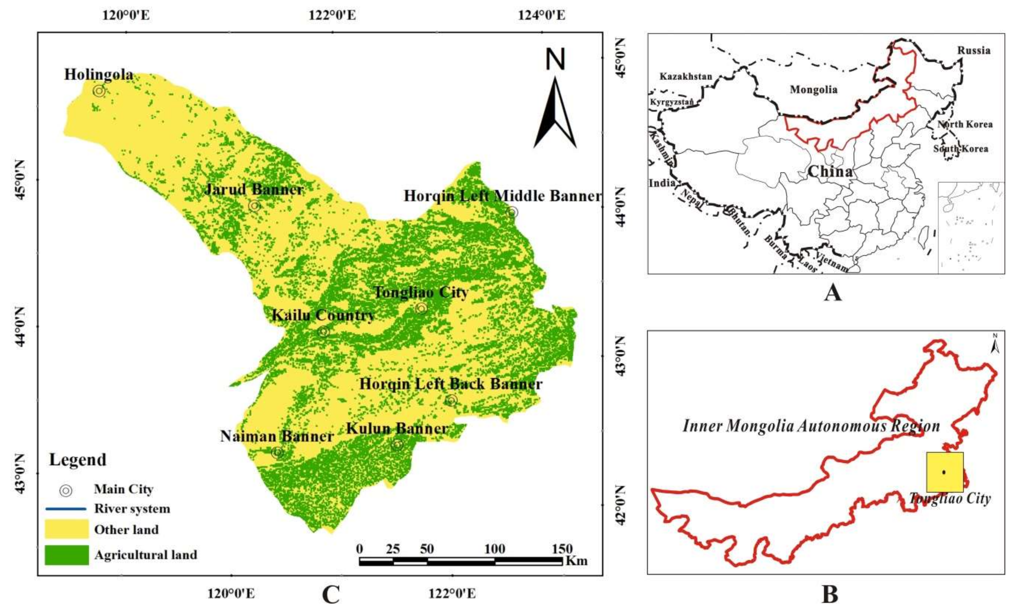
2.1. Study Area
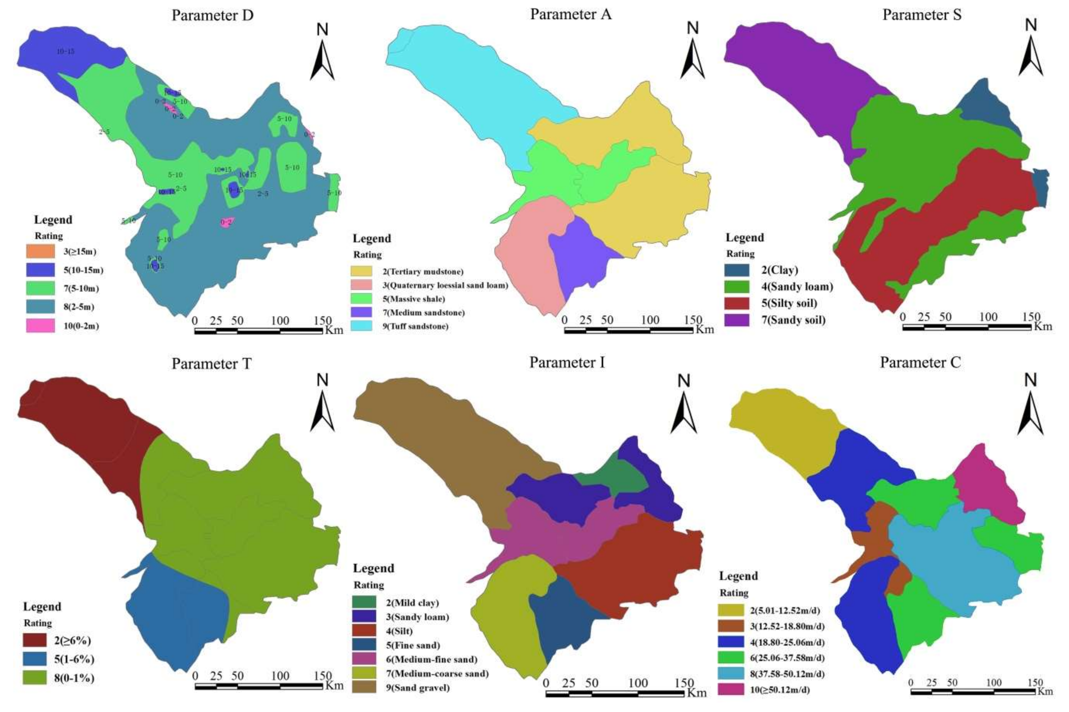
2.2. The DRASTIC Method
3. Results
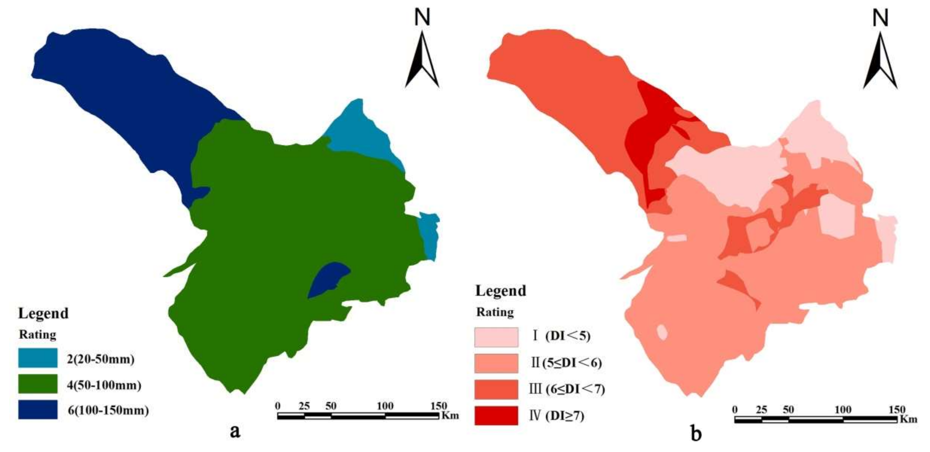
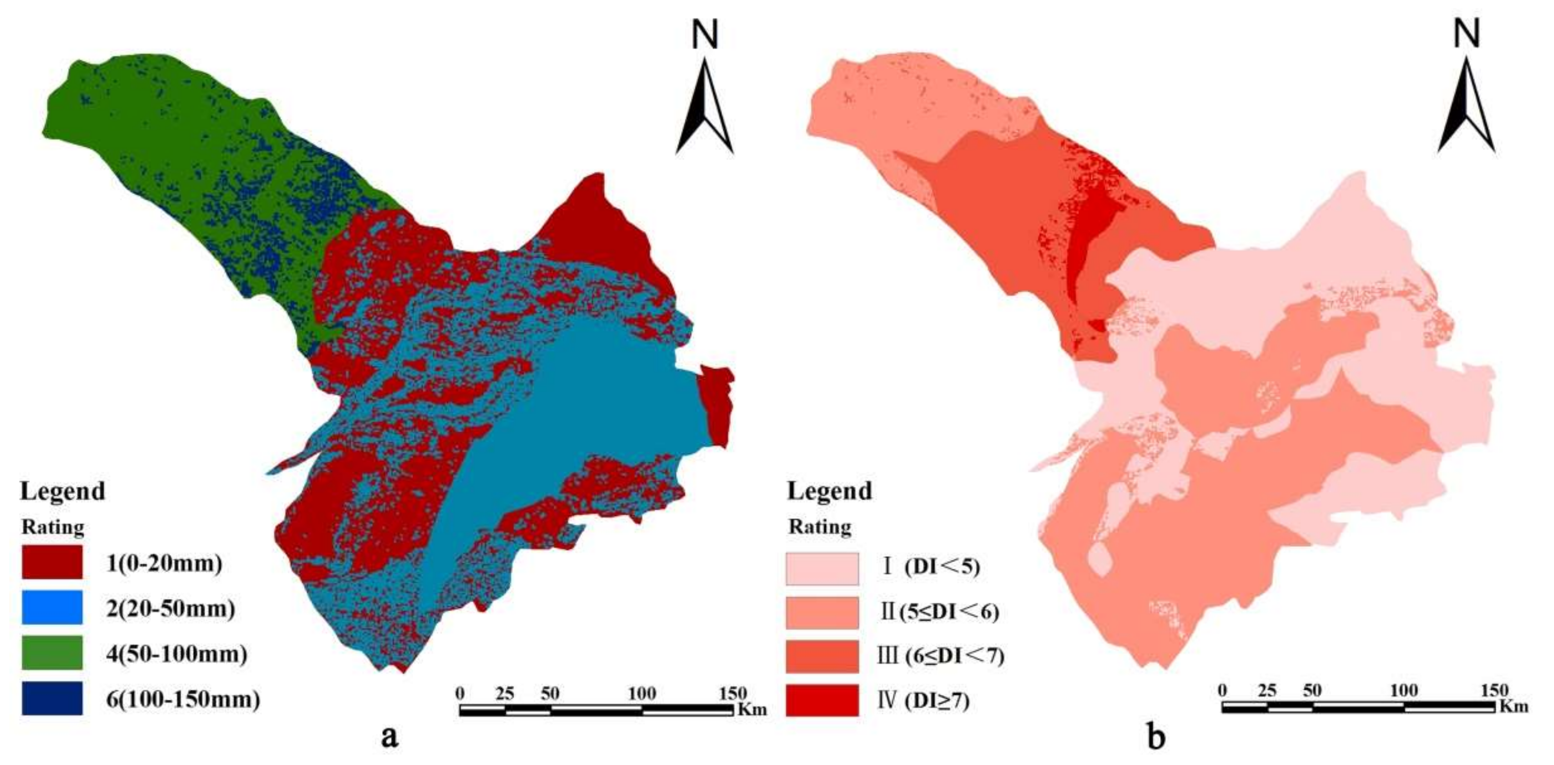
3.1. Groundwater Vulnerability in Scenario 1
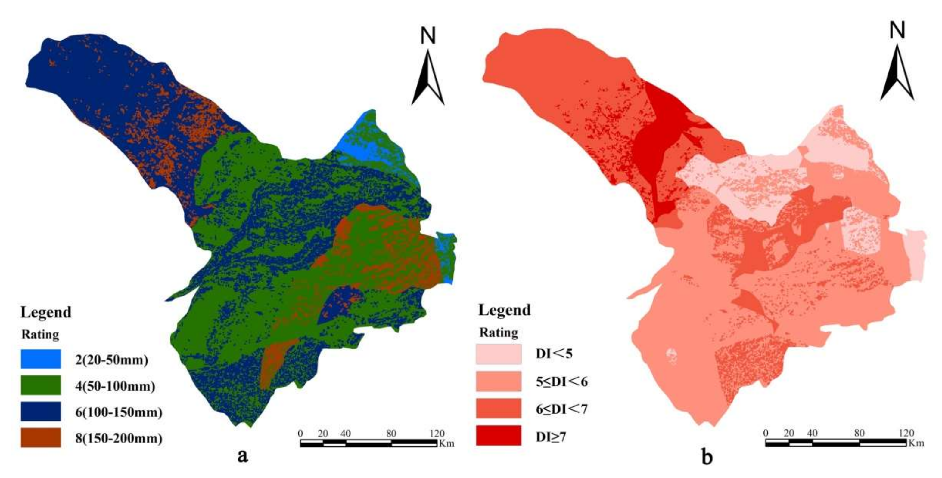
3.2. Groundwater Vulnerability in Scenario 2
3.3. Groundwater Vulnerability in Scenario 3
4. Discussion
4.1. Influence of the Agricultural Irrigation Activity on the Groundwater Pollution Risk
4.2. Uncertainty Analysis
5. Conclusions
Author Contributions
Funding
Conflicts of Interest
References
- Siebert, S.; Burke, J.; Faures, J.; Frenken, K.; Hoogeveen, J.; Döll, P.; Portmann, F. Groundwater use for irrigation-A global inventory. Hydrol. Earth Syst. Sci. 2010, 14, 1863–1880. [Google Scholar] [CrossRef]
- Mongat, A.S.; Arshad, M.; Bakhsh, A.; Shakoor, A.; Anjum, L.; Hameed, A.; Umm-e-Kalsoom Shamim, F. Design, installation and evaluation of solar drip irrigation system at mini dam command area. Pak. J. Agric. Sci. 2015, 52, 483–490. [Google Scholar]
- Wada, Y.; van Beek, L.P.H.; van Kempen, C.M.; Reckman, J.W.T.M.; Vasak, S.; Bierkens, M.F.P. Global depletion of groundwater resources. Geophys. Res. Lett. 2010, 37, L20402. [Google Scholar] [CrossRef]
- Nelson, R.L. Assessing local planning to control groundwater depletion: California as a microcosm of global issues. Water Resour. Res. 2012, 48, 1502. [Google Scholar] [CrossRef]
- Gardner, K.K.; Vogel, R.M. Predicting ground water nitrate concentration from land use. Groundwater 2005, 43, 343–352. [Google Scholar] [CrossRef]
- Kundzewicz, Z.W.; Mata, L.J.; Arnell, N.W.; Döll, P.; Kabat, P.; Jiménez, B.; Miller, K.A.; Oki, T.; Sen, Z.; Shiklomanov, I.A. Freshwater resources and their management. In Climate Change 2007: Impacts, Adaptation and Vulnerability; Contribution of Working Group II to the Fourth Assessment Report of the Intergovernmental Panel on Climate Change; Cambridge University Press: Cambridge, UK, 2007. [Google Scholar]
- Wandl, A.; Magoni, M. Sustainable planning of peri-urban areas: Introduction to the special issue planning. Pract. Res. 2017, 32, 1–3. [Google Scholar] [CrossRef]
- Uricchio, V.F.; Giordano, R.; Lopez, N. A fuzzy knowledge-based decision support system for groundwater pollution risk evaluation. J. Environ. Manag. 2004, 73, 189–197. [Google Scholar] [CrossRef]
- Margat, T.J. Vulnérabilité des Nappes D’eau Souterraines à la Pollution: Bases de la Cartographie [Vulnerability of Groundwater to Pollution: The Basics of Cartography]; Document 68 SGL 198 HYD; Bureau de Recherches Geologiques et Minieres: Orleans, France, 1968.
- Vrba, J.; Zaporozec, A. Guidebook on Mapping Groundwater Vulnerability; International Contributions to Hydrogeology 16; Heise: Hannover, Germany, 1994. [Google Scholar]
- Babiker, I.S.; Mohamed, M.A.A.; Hiyama, T.; Kato, K. A GIS-based DRASTIC modell for assessing aquifer vulnerability in Kakamigahara Heights, Gifu prefecture, central Japan. Sci. Total Environ. 2005, 345, 127–140. [Google Scholar] [CrossRef]
- Foster, S.S.D. Fundamental concepts in aquifer vulnerability, pollution risk and protection strategy. In Proceedings of the Vulnerability of soil and groundwater to pollutants, Noordwijk, The Netherlands, 30 March–3 April 1987; Van Duijvenbooden, W., van Waegeningh, H.G., Eds.; Netherlands Organization for Applied Scientific Research: The Hauge, The Netherlands, 1987; pp. 69–86. [Google Scholar]
- Aller, L.; Bennet, T.; Lehr, J.H.; Petty, R.J. DRASTIC: A Standardized System for Evaluating Groundwater Pollution Potential Using Hydro Geologic Settings; Technical Report No. EPA/600/2-85-018; U.S.EPA: Washington, DC, USA, 1987.
- Stempvoort, D.V.; Evert, L.; Wassenaar, L. Aquifer vulnerability index: A GIS compatible method for groundwater vulnerability mapping. Can. Wat. Res. J. 1993, 18, 25–37. [Google Scholar] [CrossRef]
- Civita, M. Le Carte della Vulnerabilità degli Acquiferi All’inquinamento: Teoria & Practica (Aquifer Vulnerability Maps to Pollution); Pitagora: Bologna, Italy, 1994; p. 325. (In Italian) [Google Scholar]
- Gogu, R.; Dassargues, A. Current trends and future challenges in groundwater vulnerability assessment using overlay and index methods. Environ. Geol. 2000, 39, 549–555. [Google Scholar] [CrossRef]
- Bai, L.P.; Wang, Y.Y.; Meng, F.S. Application of DRASTIC and extension theory in the groundwater vulnerability evaluation. Water Environ. J. 2012, 26, 381–391. [Google Scholar] [CrossRef]
- Su, X.; Xu, W.; Du, S.H. Responses of groundwater vulnerability to artificial recharge under extreme weather conditions in Shijiazhuang City, China. J. Water Supply Res. Technol. Aqua 2014, 63, 224–238. [Google Scholar] [CrossRef]
- Zghibi, A.; Merzougui, A.; Chenini, I.; Ergaieg, K.; Zouhri, L.; Tarhouni, J. Groundwater Vulnerability Analysis of Tunisian coastal aquifer: An application of DRASTIC Index Method in GIS environment. Groundw. Sustain. Dev. 2016, 2, 169–181. [Google Scholar] [CrossRef]
- Krogulec, E.; Trzeciak, T. DRASTIC assessment of groundwater vulnerability to pollution in the Vistula floodplain in central Poland. Hydrol. Res. 2017, 48, 1088–1099. [Google Scholar] [CrossRef]
- Akenji, V.N.; Ako, A.A.; Ayuk, A.R.; Hosono, T. DRASTIC-GIS modell for assessing vulnerability to pollution of the phreatic aquiferous formations in Douala-Cameroon. J. Afr. Earth Sci. 2015, 102, 180–190. [Google Scholar]
- Moustafa, M. Assessing perched aquifer vulnerability using modified DRASTIC: A case study of colliery waste in north-east England (UK). Hydrogeol. J. 2019, 27, 1837–1850. [Google Scholar] [CrossRef]
- Jhariya, D.C. Assessment of Groundwater Pollution Vulnerability Using GIS-Based DRASTIC Model and its Validation Using Nitrate Concentration in Tandula Watershed, Chhattisgarh. J. Geol. Soc. India 2019, 93, 567–573. [Google Scholar] [CrossRef]
- Khosravi, K.; Sartaj, M.; Tsai, F.T.C.; Singh, V.P.; Kazakis, N.; Melesse, A.M.; Prakash, I.; Bui, D.T.; Pham, B.T. A comparison study of DRASTIC methods with various objective methods for groundwater vulnerability assessment. Sci. Total Environ. 2018, 642, 1032–1049. [Google Scholar] [CrossRef]
- Shrestha, S.; Semkuyu, D.J.; Pandey, V.P. Assessment of groundwater vulnerability and risk to pollution in Kathmandu Valley, Nepal. Sci. Total Environ. 2016, 15, 23–35. [Google Scholar] [CrossRef]
- Ahirwar, S.; Shukla, J.P. Assessment of Groundwater Vulnerability in Upper Betwa River Watershed using GIS based DRASTIC Model. J. Geol. Soc. India 2018, 91, 334–340. [Google Scholar] [CrossRef]
- Jhariya, D.C.; Kumar, T.; Pandey, H.K.; Kumar, S.; Kumar, D.; Gautam, A.K.; Baghel, V.S.; Kishore, N. Assessment of groundwater vulnerability to pollution by modified DRASTIC model and analytic hierarchy process. Environ. Earth Sci. 2019, 78, 610. [Google Scholar] [CrossRef]
- Singha, S.S.; Pasupuleti, S.; Singha, S.; Singh, R.; Venkatesh, A.S. A GIS-based modified DRASTIC approach for geospatial modeling of groundwater vulnerability and pollution risk mapping in Korba district, Central India. Environ. Earth Sci. 2019, 78, 628. [Google Scholar] [CrossRef]
- Zhao, Y.; Zhang, J.; Chen, Z.; Zhang, W. Groundwater contamination risk assessment based on intrinsic vulnerability, pollution source assessment, and groundwater function zoning. Hum. Ecol. Risk Assess. Int. J. 2019, 25, 1907–1923. [Google Scholar] [CrossRef]
- Chen, R.H.; Teng, Y.G.; Chen, H.Y.; Hu, B.; Yue, W.F. Groundwater pollution and risk assessment based on source apportionment in a typical cold agricultural region in Northeastern China. Sci. Total Environ. 2019, 696. [Google Scholar] [CrossRef] [PubMed]
- Aldaya, M.M.; Rodriguez, C.I.; Fernandez-Poulussen, A.; Merchan, D.; Beriain, M.J.; Llamas, R. Grey water footprint as an indicator for diffuse nitrogen pollution: The case of Navarra, Spain. Sci. Total Environ. 2020, 698. [Google Scholar] [CrossRef]
- Bouraoui, F.; Grizzetti, B. An integrated modellling framework to estimate the fate of nutrients: Application to the Loire (France). Ecol. Modell. 2007, 212, 450–459. [Google Scholar] [CrossRef]
- Hao, S.N.; Li, X.Y.; Du, X.Z.; Zhang, W.S. A review on non-point source nutrient pollution of irrigation plain areas. Ecol. Environ. Sci. 2015, 24, 1235–1244. [Google Scholar]
- Wu, Y.; Liu, J.; Shen, R.; Fu, B. Mitigation of nonpoint source pollution in rural areas: From control to synergies of multi ecosystem services. Sci. Total Environ. 2017, 607, 1376–1380. [Google Scholar] [CrossRef]
- Xu, D.P.; Xue, X.J.; Zhu, J.W. Optimization of the development pattern of agriculture and animal husbandry in Tongliao based on the idea of sustainable development. J. Xi’an Univ. Technol. 2017, 33, 276–281. [Google Scholar]
- Iqbal, J.; Gorai, A.K.; Katpatal, Y.B.; Pathak, G. Development of GIS-based fuzzy pattern recognition modell modified DRASTIC modell for groundwater vulnerability to pollution assessment. Int. J. Environ. Sci. Technol. 2015, 12, 3161–3174. [Google Scholar] [CrossRef]
- Ouedraogo, I.; Defourny, P.; Vanclooster, M. Mapping the groundwater vulnerability for pollution at the pan African scale. Sci. Total Environ. 2016, 544, 939–953. [Google Scholar] [CrossRef] [PubMed]
- Shahab, A.; Shihua, Q.; Rad, S.; Keita, S.; Khan, M.; Adnan, S. Groundwater vulnerability assessment using GIS-based DRASTIC method in the irrigated and coastal region of Sindh province, Pakistan. Hydrol. Res. 2019, 50, 319–338. [Google Scholar] [CrossRef]
- China Geological Survey. Results Report of China Geological Survey: Investigation and Evaluation of Groundwater Resources and Environmental Problems in West Liaohe Plain; Geological Publishing House: Beijing, China, 2009. [Google Scholar]
- Posen, P.; Lovett, A.; Hiscock, K.; Evers, S.; Ward, R.; Reid, B. Incorporating variations in pesticide catabolic activity into a GIS-based groundwater risk assessment. Sci. Total Environ. 2006, 367, 641–652. [Google Scholar] [CrossRef] [PubMed]
- Rahman, A. A GIS-based DRASTIC modell for assessing groundwater vulnerability in the shallow aquifer in Aligarh, India. Appl. Geogr. 2008, 28, 32–53. [Google Scholar] [CrossRef]
- Kowalska, J.B.; Mazurek, R.; Gasiorek, M.; Zaleski, T. Pollution indices as useful tools for the comprehensive evaluation of the degree of soil contamination-A review. Environ. Geochem. Health 2018, 40, 2395–2420. [Google Scholar] [CrossRef] [PubMed]
- Shekhar, S.; Pandey, A.C. A GIS-based DRASTIC modell for assessing groundwater vulnerability in hard rock granitic aquifer. Arab. J. Geosci. 2015, 8, 1385–1401. [Google Scholar] [CrossRef]
- Min, L.L.; Qi, Y.Q.; Shen, Y.J.; Wang, P.; Wang, S.Q.; Liu, M.Y. Groundwater recharge under irrigated agro-ecosystems in the North China Plain: From a critical zone perspective. J. Geogr. Sci. 2019, 29, 877–890. [Google Scholar] [CrossRef]
- Chen, X.H. Streambed hydraulic conductivity for rivers in south-central Nebfaska. J. Am. Water Resour. Assoc. 2004, 40, 561–573. [Google Scholar] [CrossRef]
- Li, R.; Merchant, J.W. Modelling vulnerability of groundwater to pollution under future scenarios of climate change and biofuels-related land use change: A case study in North Dakota, USA. Sci. Total Environ. 2013, 447, 32–45. [Google Scholar] [CrossRef]
- Xu, W.; Meng, L.J.; Liu, P.; Dong, K.B. Use of a modified chloride mass balance technique to assess the factors that influence groundwater recharge rates in a semi-arid agricultural region in China. Environ. Earth Sci. 2019, 78, 241. [Google Scholar] [CrossRef]
- Ckakraborty, S.; Paul, P.K.; Sikdar, P.K. Assessing aquifer vulnerability to arsenic pollution using DRASTIC and GIS of North Bengal Plain: A case study of English Bazar Block, Malda District, West Bengal, India. J. Spat. Hydrol. 2007, 7, 101–121. [Google Scholar]
- Jang, W.; Engel, B.; Harbor, J.; Theller, L. Aquifer vulnerability assessment for sustainable groundwater management using DRASTIC. Water 2017, 9, 792. [Google Scholar] [CrossRef]
- Ersoy, A.F.; Gültekin, F. DRASTIC-based methodology for assessing groundwater vulnerability in the Gümüşhacıköy and Merzifon basin (Amasya, Turkey). Earth Sci. Res. J. 2013, 17, 33–40. [Google Scholar]
- Chenini, S.; Zghibi, A.; Kouzana, L. Hydrogeological investigations and groundwater vulnerability assessment and mapping for groundwater resource protection and management: State of the art and a case study. J. Afr. Earth Sci. 2015, 109, 11–26. [Google Scholar] [CrossRef]
- He, H.; Li, X.G.; Li, X.; Cui, J.; Zhang, W.J.; Xu, W. Optimizing the DRASTIC Method for Nitrate Pollution in Groundwater Vulnerability Assessments: A Case Study in China. Pol. J. Environ. Stud. 2018, 27, 95–107. [Google Scholar] [CrossRef]
- Kumar, A.; Singh, C.K. Characterization of hydrogeochemical processes and fluoride enrichment in groundwater of South-Western Punjab. Water Qual. Expo. Health 2015, 7, 373. [Google Scholar] [CrossRef]
- Li, C.C.; Gao, X.B.; Liu, Y.S.; Wang, Y.X. Impact of anthropogenic activities on the enrichment of fluoride and salinity in groundwater in the Yuncheng Basin constrained by Cl/Br ratio, delta O-18, delta H-2, delta C-13 and delta Li-7 isotopes. J. Hydrol. 2019, 579. [Google Scholar] [CrossRef]
- Lenhart, T.; Eckhardt, K.; Fohrer, N.; Frede, H.G. Comparison of two different approaches of sensitivity analysis. Phys. Chem. Earth 2002, 27, 645–654. [Google Scholar] [CrossRef]
- Su, X.; Xu, W.; Yang, F.; Zhu, P. Using new mass balance methods to estimate gross surface water and groundwater exchange with naturally occurring tracer 222Rn in data poor regions: A case study in northwest China. Hydrol. Process. 2015, 29, 979–990. [Google Scholar] [CrossRef]
- Delhomme, J.P. Spatial variability and uncertainty in groundwater flow parameters: A geostatistical approach. Water Resour. Res. 1979, 15, 269–280. [Google Scholar] [CrossRef]
- Bhatt, K. Uncertainty in wellhead protection area delineation due to uncertainty in aquifer parameter values. J. Hydrol. 1993, 149, 1–8. [Google Scholar] [CrossRef]
| Parameter | Rating | Weight | Range/Class |
|---|---|---|---|
| Depth to water table (D) | 10 | 0.22 | 0–2 m |
| 8 | 2–5 m | ||
| 7 | 5–10 m | ||
| 5 | 10–15 m | ||
| 3 | 15 m + | ||
| Net recharge (R) | 1 | 0.17 | 0–20 mm/a |
| 2 | 20–50 mm/a | ||
| 4 | 50–100 mm/a | ||
| 6 | 100–150 mm/a | ||
| 8 | 150–200 mm/a | ||
| Aquifer medium (A) | 9 | 0.13 | Tuff sandstone |
| 7 | Medium sandstone | ||
| 5 | Massive shale | ||
| 3 | Quaternary loessial sandy loam | ||
| 2 | Tertiary mudstone | ||
| Soil medium (S) | 7 | 0.09 | Sandy soil |
| 5 | Silty soil | ||
| 4 | Sandy loam | ||
| 2 | Clay | ||
| Topography (T) | 8 | 0.04 | 0–1 % |
| 5 | 1–6% | ||
| 2 | ≥6% | ||
| Vadose zone medium impact (I) | 9 | 0.22 | Sand gravel |
| 7 | Medium-coarse sand | ||
| 6 | Medium-fine sand | ||
| 5 | Fine sand | ||
| 4 | Silt | ||
| 3 | Sandy loam | ||
| 2 | Mild clay | ||
| Hydraulic conductivity (C) | 10 | 0.13 | 50.12 m/d + |
| 8 | 37.58–50.12 m/d | ||
| 6 | 25.06–37.58 m/d | ||
| 4 | 18.80–25.06 m/d | ||
| 3 | 12.52–18.80 m/d | ||
| 2 | 5.01–12.52 m/d |
| Soil Medium | Rainfall Infiltration Coefficient γ | Irrigation Infiltration Coefficient β | Total Infiltration Coefficient α (%) |
|---|---|---|---|
| Clay | 0.11 | 0.20 | 2.50 |
| Sandy loam | 0.18 | 0.28 | 7.80 |
| Silty soil | 0.25 | 0.30 | 5.30 |
| Sandy soil | 0.30 | 0.32 | 20.30 |
| Pollution Risk Region | Risk Level | Scenario 1 | Scenario 2 | Scenario 3 |
|---|---|---|---|---|
| Relatively low-risk region | Level Ⅰ (DI < 5) | 15.51% | 11.54% | 34.59% |
| Level Ⅱ (5 ≤ DI < 6) | 50.72% | 47.86% | 46.19% | |
| Relatively high-risk region | Level Ⅲ (6 ≤ DI < 7) | 28.94% | 33.51% | 16.70% |
| Level Ⅳ (DI ≥ 7) | 4.83% | 7.09% | 2.52% |
| Measuring Error | D | R | A | S | T | I | C |
|---|---|---|---|---|---|---|---|
| 5% | 0% | 0% | 42.06% | 0% | 0% | 43.65% | 0% |
| 10% | 0% | 42.06% | 43.65% | 42.06% | 0% | 128.97% | 0% |
| 20% | 43.65% | 42.46% | 43.65% | 42.46% | 0% | 128.97% | 0% |
| 30% | 43.65% | 68.25% | 43.65% | 127.78% | 0% | 128.97% | 42.46% |
| 40% | 51.19% | 129.76% | 43.65% | 128.97% | 3.17% | 128.97% | 42.46% |
| 50% | 81.75% | 163.10% | 43.65% | 129.76% | 5.16% | 128.97% | 77.38% |
© 2020 by the authors. Licensee MDPI, Basel, Switzerland. This article is an open access article distributed under the terms and conditions of the Creative Commons Attribution (CC BY) license (http://creativecommons.org/licenses/by/4.0/).
Share and Cite
Meng, L.; Zhang, Q.; Liu, P.; He, H.; Xu, W. Influence of Agricultural Irrigation Activity on the Potential Risk of Groundwater Pollution: A Study with Drastic Method in a Semi-Arid Agricultural Region of China. Sustainability 2020, 12, 1954. https://doi.org/10.3390/su12051954
Meng L, Zhang Q, Liu P, He H, Xu W. Influence of Agricultural Irrigation Activity on the Potential Risk of Groundwater Pollution: A Study with Drastic Method in a Semi-Arid Agricultural Region of China. Sustainability. 2020; 12(5):1954. https://doi.org/10.3390/su12051954
Chicago/Turabian StyleMeng, Lingjun, Qixing Zhang, Pai Liu, Haiyang He, and Wei Xu. 2020. "Influence of Agricultural Irrigation Activity on the Potential Risk of Groundwater Pollution: A Study with Drastic Method in a Semi-Arid Agricultural Region of China" Sustainability 12, no. 5: 1954. https://doi.org/10.3390/su12051954
APA StyleMeng, L., Zhang, Q., Liu, P., He, H., & Xu, W. (2020). Influence of Agricultural Irrigation Activity on the Potential Risk of Groundwater Pollution: A Study with Drastic Method in a Semi-Arid Agricultural Region of China. Sustainability, 12(5), 1954. https://doi.org/10.3390/su12051954


