Impact of the Spatial Configuration of Streets Networks on Urban Growth: A Case Study of Abha City, Saudi Arabia


Abstract
1. Introduction
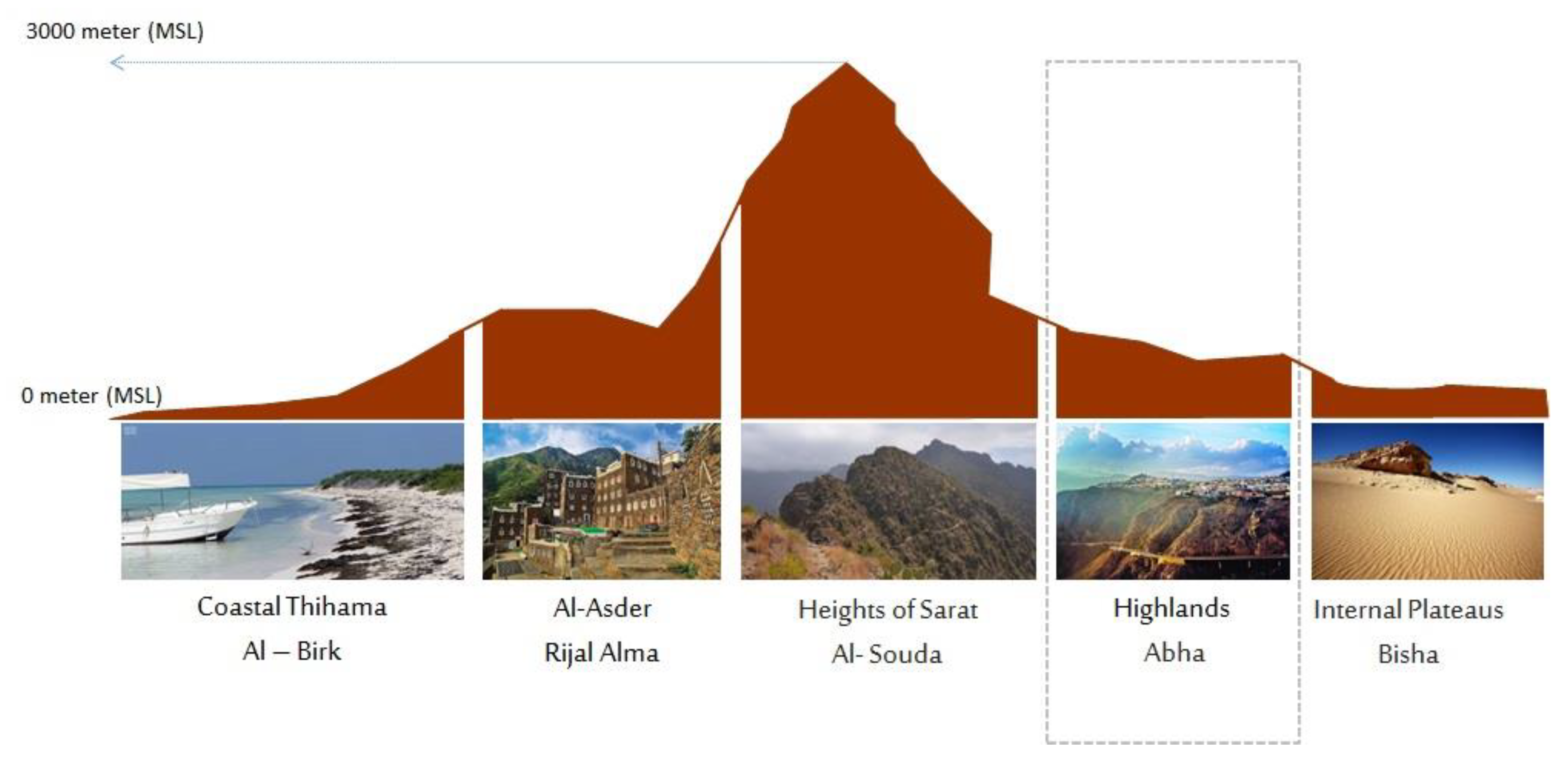
2. Case Study
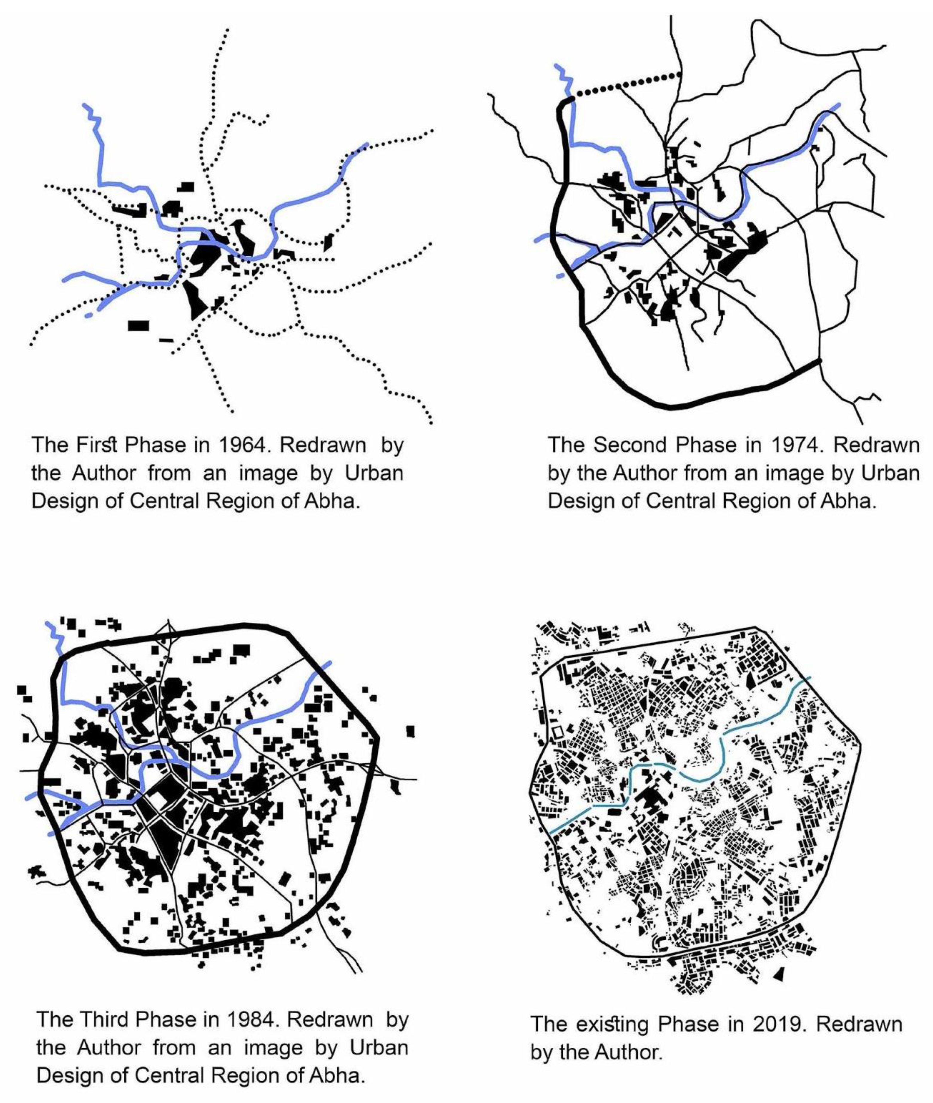
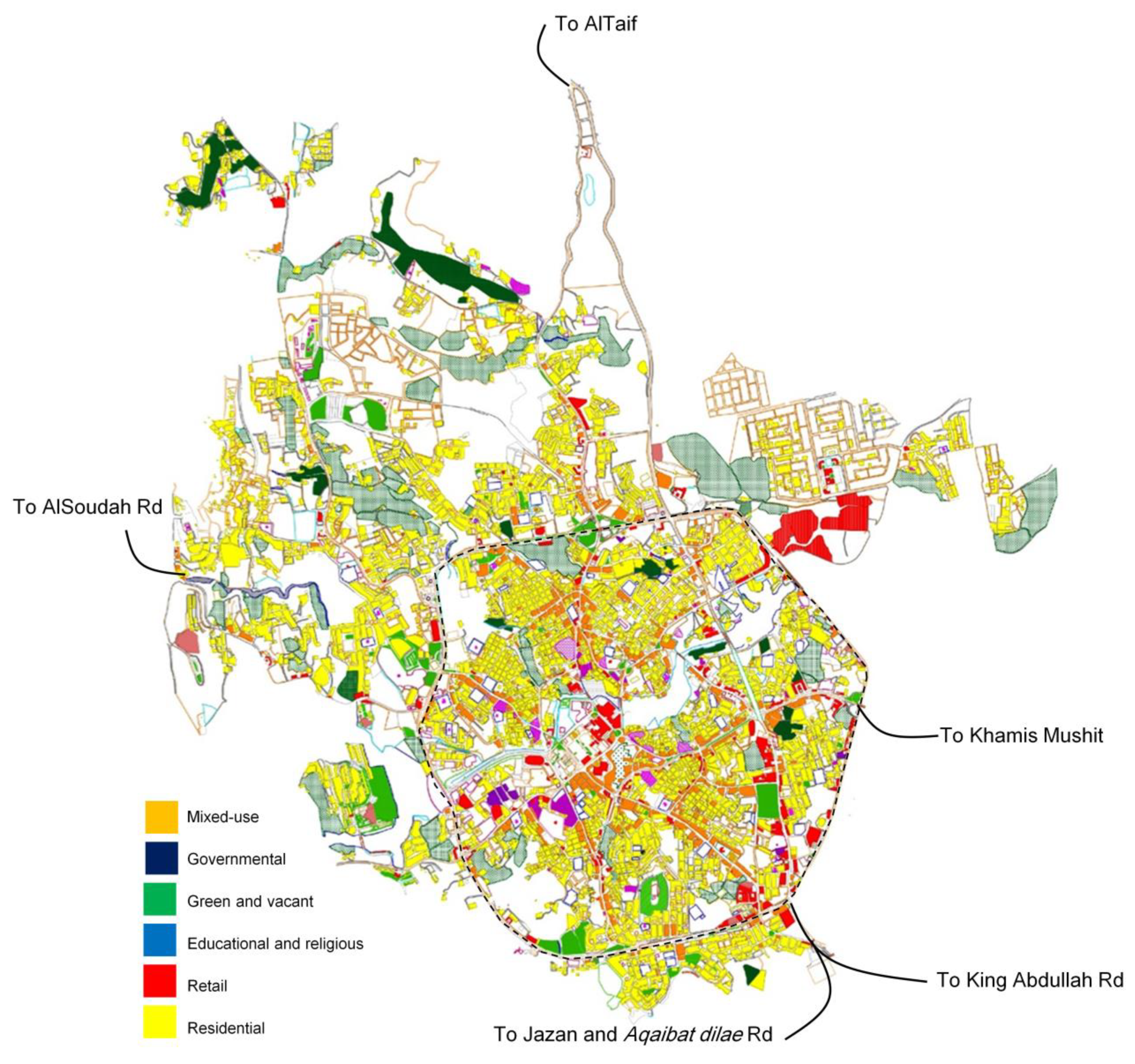
A Background of the Urban Fabric Growth on the Case Study of the City of Abha
3. Methods
3.1. Space Syntax Theory
3.1.1. Spatial Configuration
“All these ways of looking at space can be seen as layers of spatial structuring, co-existing within the same plan, each with its own contribution to intelligibility and function.” [24].
3.1.2. Axial and Segment Maps
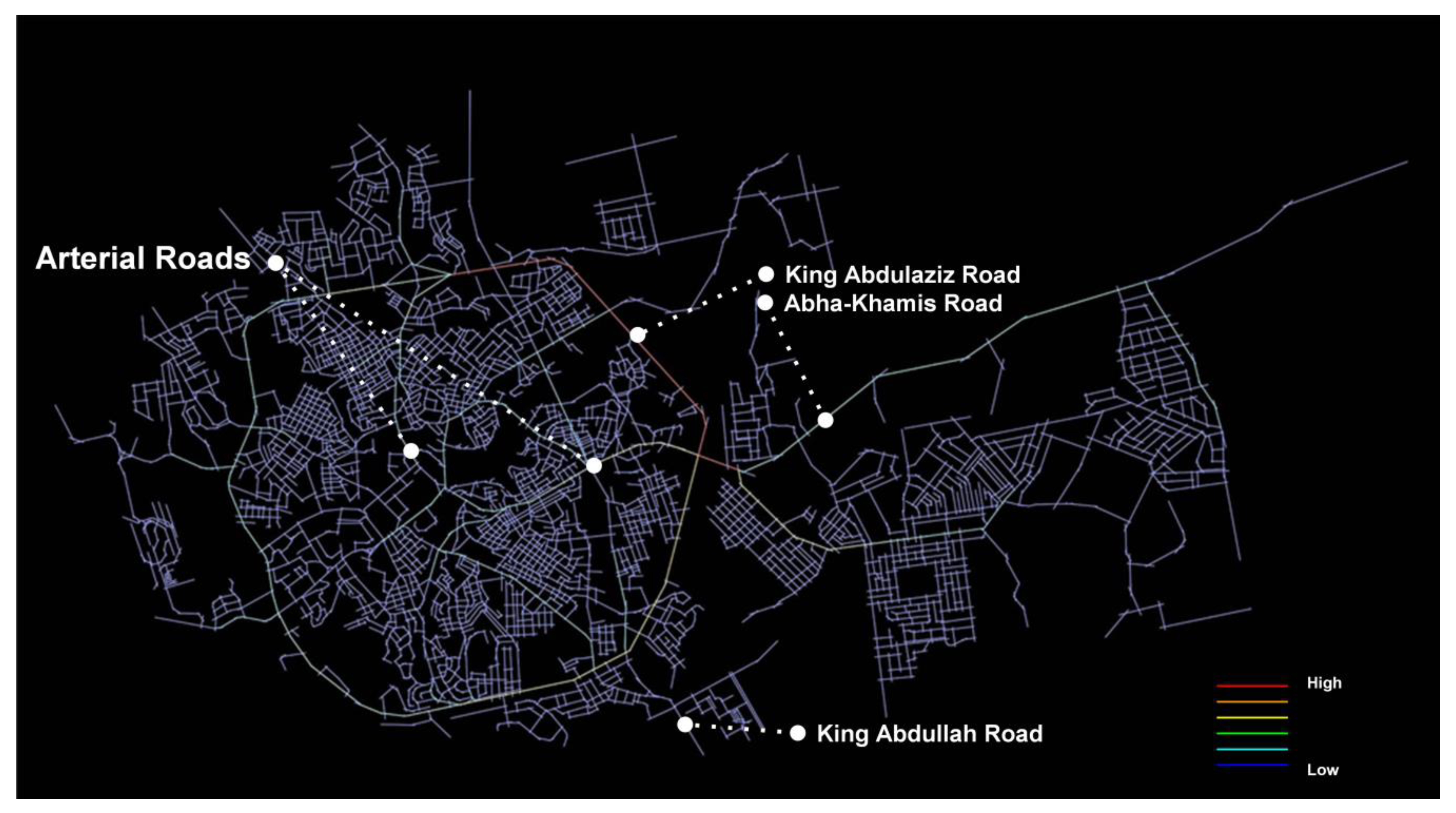
3.2. Spatial Analysis for Abha City
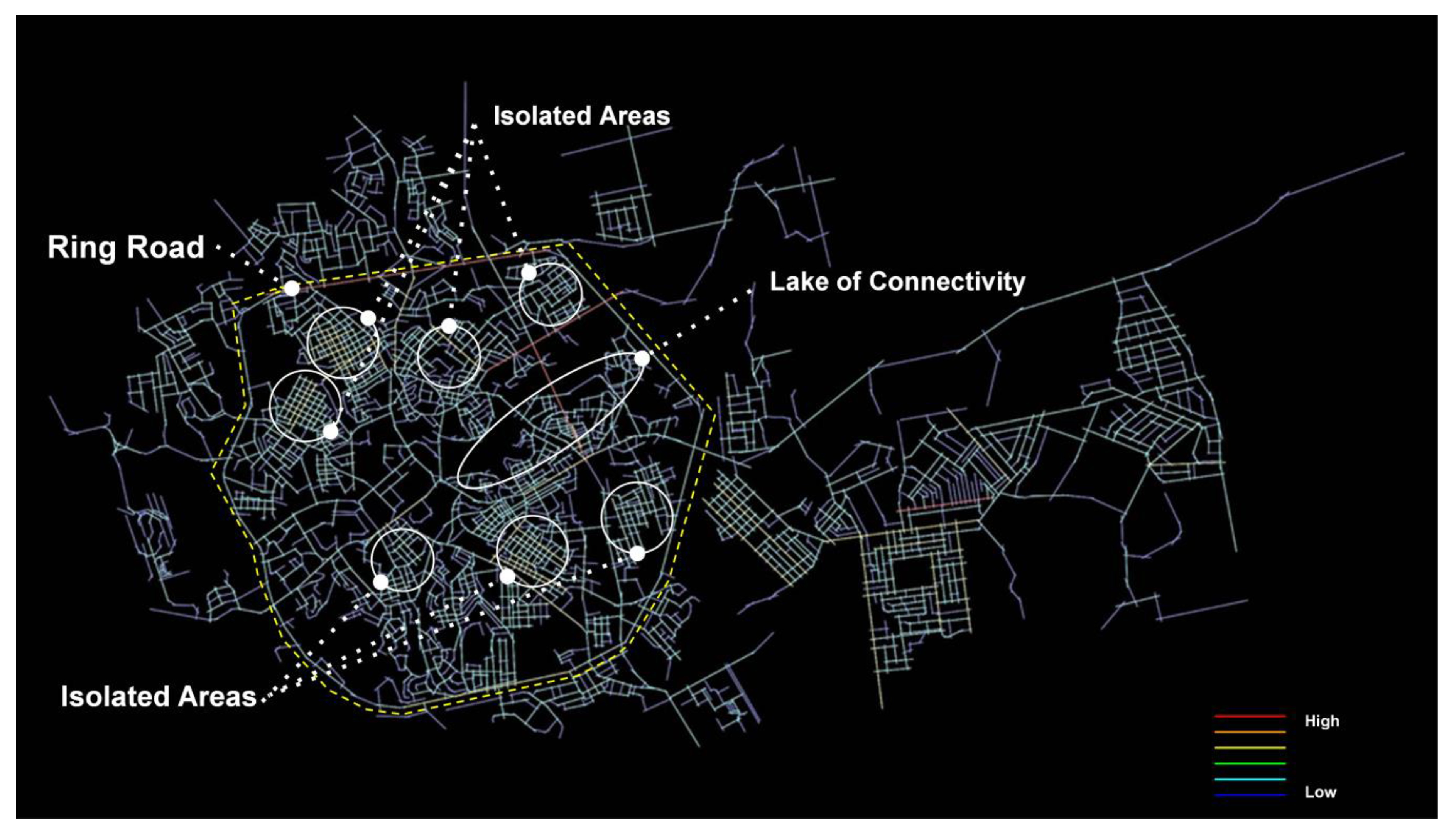
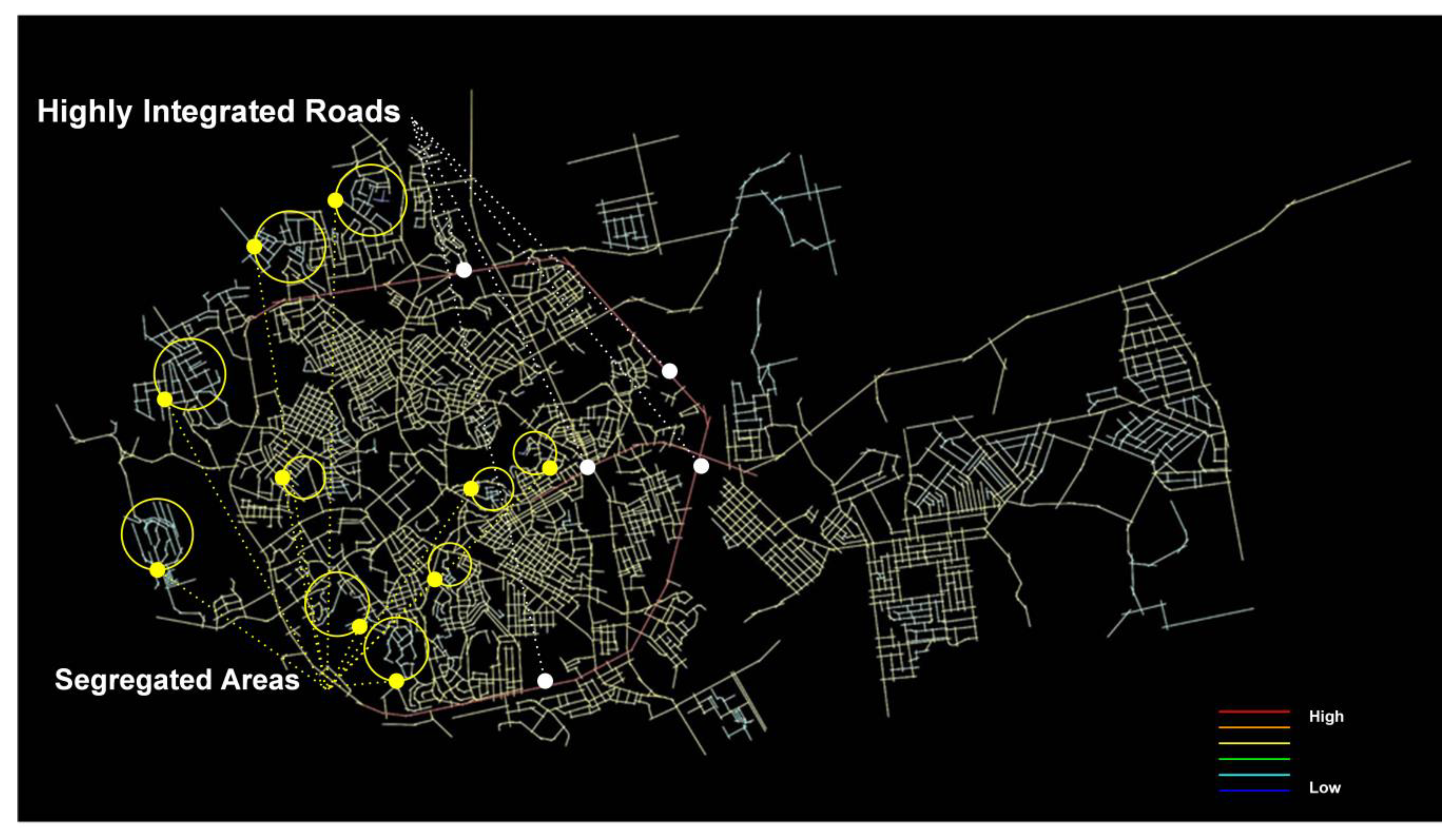
4. Results and Discussion
5. Conclusions
Author Contributions
Funding
Acknowledgments
Conflicts of Interest
References
- Burgess, E.W. The growth of the city: An introduction to a research project. In The City; Park, R.E., Burgess, E.W., Mackenzie, R.D., Eds.; University of Chicago Press: Chicago, IL, USA, 1927; pp. 1–47. [Google Scholar]
- Proudfoot, M.J.; Hoyt, H. The Structure and Growth of Residential Neighborhoods in American Cities; US Government Printing Office: Washington, DC, USA, 1939.
- Alonso, W. Location and Land Use; Harvard University Press: Cambridge, MA, USA, 1964. [Google Scholar]
- Kropf, K. Aspects of urban form. Urban Morphol. 2009, 13, 105. [Google Scholar]
- Rotem-Mindali, O. Retail fragmentation vs. urban livability: Applying ecological methods in urban geography research. Appl. Geogr. 2012, 35, 292–299. [Google Scholar] [CrossRef]
- Jake, D. The Relationship between Urban Street Configuration and Office Rent Patterns in Berlin. Ph.D. Thesis, University College London, London, UK, 2000. [Google Scholar]
- Kim, H.K.; Sohn, D.W. An analysis of the relationship between land use density of office buildings and urban street configuration: Case studies of two areas in Seoul by space syntax analysis. Cities 2002, 19, 409–418. [Google Scholar] [CrossRef]
- Nes, A. van Typology of shopping areas in Amsterdam. In Proceedings of the 5th International Space Syntax Symposium, Delft, The Netherlands, 13–17 June 2005. [Google Scholar]
- Ortiz-Chao, C.; Hillier, B. In search of patterns of land-use in Mexico City using logistic regression at the plot level. In Proceedings of the 6th International Space Syntax Symposium, Istanbul, Turkey, 12–15 June 2007. [Google Scholar]
- Porta, S.; Strano, E.; Iacoviello, V.; Messora, R.; Latora, V.; Cardillo, A.; Wang, F.; Scellato, S. Street centrality and densities of retail and services in Bologna, Italy. Environ. Plan. B Plan. Des. 2009, 36, 450–465. [Google Scholar] [CrossRef]
- Lin, S.; Jianhua, X.; Shen, Q.; Yang, Y. A research on urban spatial morphology and land use type based on space syntax: A case study on Lujiazui functional area Urban Geography 19 Downloaded by [University of California, San Diego] at 06:34 08 March 2016 of Shanghai. In Proceedings of the 2nd International Conference on Computer Engineering and Technology, Chengdu, China, 16–19 April 2010. [Google Scholar]
- Wang, F.; Antipova, A.; Porta, S. Street centrality and land use intensity in Baton Rouge, Louisiana. J. Transp. Geogr. 2011, 19, 285–293. [Google Scholar] [CrossRef]
- Vaughan, L.; Jones, C.; Griffiths, S.; Haklay, M. The spatial signature of suburban town centres. J. Sp. Syntax 2010, 1, 77–91. [Google Scholar]
- Soesanti, S.; Nakai, N. Street network in Bandung city, Indonesia: Comparison between city center and new commercial area. World Acad. Sci. Eng. Technol. 2010, 42, 1104–1114. [Google Scholar]
- Porta, S.; Latora, V.; Wang, F.; Rueda, S.; Strano, E.; Scellato, S.; Cardillo, A.; Belli, E.; Càrdenas, F.; Cormenzana, B.; et al. Street Centrality and the Location of Economic Activities in Barcelona. Urban Stud. 2012, 49, 1471–1488. [Google Scholar] [CrossRef]
- Srirangam, S.; Forsyth, W. Culture and Commerce of Chennai City—A spatial analysis of the relationship between temples and retail activity. In Proceedings of the 8th International Space Syntax Symposium, Santiago, Chile, 3–6 January 2012. [Google Scholar]
- Wang, F.; Chen, C.; Xiu, C.; Zhang, P. Location analysis of retail stores in Changchun, China: A street centrality perspective. Cities 2014, 41, 54–63. [Google Scholar] [CrossRef]
- Scoppa, M.D.; Peponis, J. Distributed attraction: The effects of street network connectivity upon the distribution of retail frontage in the city of buenos aires. Environ. Plan. B Plan. Des. 2015, 42, 354–378. [Google Scholar] [CrossRef]
- Liu, P.; Xiao, X.; Zhang, J.; Wu, R.; Zhang, H. Spatial configuration and online attention: A space syntax perspective. Sustainability 2018, 10, 221. [Google Scholar] [CrossRef]
- Shukla, V.; Parikh, K. The environmental consequences of urban growth: Crossnational perspectives on economic development, air pollution, and city size. Urban Geogr. 1992, 13, 422–449. [Google Scholar] [CrossRef]
- Roorda-Knape, M.C.; Janssen, N.A.; De Hartog, J.J.; Van Vliet, P.H.; Harssema, H.; Brunekreef, B. Air pollution from traffic in city districts near major motorways. Atmos. Environ. 1998, 32, 1921–1930. [Google Scholar] [CrossRef]
- Kanani, S.; Zandi, H. A study of the damages to historical monuments due to climatic factors and air pollution and offering solutions. WASET 2011, 56, 593–596. [Google Scholar]
- Hillier, B.; Hanson, J. The Social Logic of Space; Cambridge University Press: Cambridge, MA, USA, 1989. [Google Scholar]
- Hillier, B. Space Is the Machine; Cambridge University Press: Cambridge, MA, USA, 1996. [Google Scholar]
- Hillier, B. The art of place and the science of space. World Archit. 2005, 185, 96–102. [Google Scholar]
- Hillier, B. Space and spatiality: What the built environment needs from social theory. Build. Res. Inf. 2008, 36, 216–230. [Google Scholar] [CrossRef]
- Bafna, S. Space Syntax A Brief Introduction to Its Logic and Analytical Techniques. Environ. Behav. 2003, 35, 17–29. [Google Scholar] [CrossRef]
- Jiang, B.; Claramunt, C. Integration of Space Syntax into GIS: New Perspectives for Urban Morphology. Trans. Gis 2002, 6, 295–309. [Google Scholar] [CrossRef]
- Maldonado, A.; Wachowicz, M.; Va´zquez-Hoehne, A. Movement surface: A multilevel approach for predicting visitor movement in nature areas. Environ. Plan. B Plan. Des. 2011, 38, 864–878. [Google Scholar] [CrossRef]
- Cozens, P.M. Sustainable urban development and crime prevention through environmental design for the British city, Towards an effective urban environmentalism for the 21st century. Cities 2002, 19, 129–137. [Google Scholar] [CrossRef]
- Du Plessis, C. The Links between Crime Prevention and Sustainable Development. Open House Int. 1999, 24, 33–40. [Google Scholar]
- Holtz, S. Integrating Environmental, Social and Economic Policies. In The Cornerstone of Development; Schnurr, J., Holtz, S., Eds.; IDRC: Ottawa, ON, Canada, 1998; pp. 283–293. [Google Scholar]
- Soberon, L. Concertación: Integrated Planning and Development in Peru. In Cornerstone of Development: Integrating Environmental, Social, and Economic Policies; IDRC: Ottawa, ON, Canada, 1998. [Google Scholar]
- Black, A.W. The Quest for Sustainable, Healthy Communities. Presented at the Effective Sustainability Education: What Works? Why? Where Next? Linking Research and Practice, Sydney, Australia, 19 February 2004. [Google Scholar]
- Bindajam, A.A.A. Describing Movement Densities in the Historic Cities of the Kingdom of Saudi Arabia USING SPACE SYNTAX: Lessons for Heritage Planning. Ph.D. Thesis, University of Kansas, Lawrence, KS, USA, 2016. [Google Scholar]
- Shaker, M. The Arabian Peninsula: The Peoples of Islamic Peoples in Asia 14-1; Islamic Office: Beirut, Lebanon, 2000. [Google Scholar]
- Al-Hamdani Abu Muhammad ibn Yusuf. Characteristics of the Arabian Peninsula; Brill Press: Leiden, The Netherlands, 1884. [Google Scholar]
- Brockelmann, C.; Perlmann, M.; Carmichael, J. History of the Islamic Peoples; Capricorn Books: New York, NY, USA, 1960; Volume 3. [Google Scholar]
- Portugali, J. What makes cities complex? In Complexity, Cognition, Urban Planning and Design; Springer: Berlin/Heidelberg, Germany, 2016; pp. 3–19. [Google Scholar]
- Al_Sayed, K.; Turner, A.; Hillier, B.; Iida, S.; Penn, A. Space Syntax Methodology; Bartlett School of Architecture, UCL: London, UK, 2014. [Google Scholar]
- Karimi, K. A configurational approach to analytical urban design: Space syntax methodology. Urban Des. Int. 2012, 17, 297–318. [Google Scholar] [CrossRef]
- Rashid, M.; Bindajam, A.A.A. Space, movement and heritage planning of the historic cities in Islamic societies: Learning from the Old City of Jeddah, Saudi Arabia. Urban Des. Int. 2015, 20, 107–129. [Google Scholar] [CrossRef]
- Rashid, M.; Wineman, J.; Zimring, C. Space, behavior, and environmental perception in open-plan offices: A prospective study. Environ. Plan. B Plan. Des. 2009, 36, 432–449. [Google Scholar] [CrossRef]
- Peponis, J.; Ross, C.; Rashid, M. The Structure of Urban Space, Movement and Co-presence: The Case of Atlanta. Geoforum 1997, 28, 341–358. [Google Scholar] [CrossRef]
- Jiang, B.; Claramunt, C. Extending space syntax towards an alternative model of space within GIS. In Proceedings of the 3rd European Agile Conference on Geographic Information Science, Helsinki, Finland, 25–27 May 2000. [Google Scholar]
- Schumacher, T. Buildings and streets: Notes on configuration and use. In On Streets; Anderson, S., Ed.; MIT Press: Cambridge, MA, USA, 1986; pp. 133–149. [Google Scholar]
- Rashid, M. The Geometry of Urban Layouts; Springer: Berlin/Heidelberg, Germany, 2017. [Google Scholar]
- Hillier, B. Spatial Sustainability in Cities: Organic Patterns and Sustainable Forms. In Proceedings of the 7th International Space Syntax, Symposium, Stockholm, Sweden, 8–11 June 2009. [Google Scholar]
- Hillier, B. A theory of the city as objects: Or, how spatial laws mediate the social construction of urban space. Urban Des. Int. 2002, 7, 153–179. [Google Scholar] [CrossRef]
- Azimzadeh, M.; Bjur, H. Transforming cities. The role of the configuration of the network of public spaces in urban life. In Proceedings of the 5th International Space Syntax Symposium, Delft, The Netherlands, 13–17 June 2005. [Google Scholar]
- Hillier, B.; Yang, T.; Turner, A. Normalising least angle choice in Depthmap and it opens up new perspectives on the global and local analysis of city space. J. Sp. Syntax 2012, 3, 155–193. [Google Scholar]
- Ratti, C. Urban texture and space syntax: Some inconsistencies. Environ. Plan. B Plan. Des. 2004, 31, 487–499. [Google Scholar] [CrossRef]
- Mallick, J. Land characterization analysis of surface temperature of semi-arid mountainous city Abha, Saudi Arabia using remote sensing and GIS. J. Geogr. Inf. Syst. 2014, 6, 664–676. [Google Scholar] [CrossRef]
- Turner, A. From Axial to Road-Centre Lines: A New Representation for Space Syntax and a New Model of Route Choice for Transport Network Analysis. Environ. Plan. B Plan. Des. 2016, 34, 539–555. [Google Scholar] [CrossRef]


© 2020 by the authors. Licensee MDPI, Basel, Switzerland. This article is an open access article distributed under the terms and conditions of the Creative Commons Attribution (CC BY) license (http://creativecommons.org/licenses/by/4.0/).
Share and Cite
Bindajam, A.A.; Mallick, J. Impact of the Spatial Configuration of Streets Networks on Urban Growth: A Case Study of Abha City, Saudi Arabia. Sustainability 2020, 12, 1856. https://doi.org/10.3390/su12051856
Bindajam AA, Mallick J. Impact of the Spatial Configuration of Streets Networks on Urban Growth: A Case Study of Abha City, Saudi Arabia. Sustainability. 2020; 12(5):1856. https://doi.org/10.3390/su12051856
Chicago/Turabian StyleBindajam, Ahmed Ali, and Javed Mallick. 2020. "Impact of the Spatial Configuration of Streets Networks on Urban Growth: A Case Study of Abha City, Saudi Arabia" Sustainability 12, no. 5: 1856. https://doi.org/10.3390/su12051856
APA StyleBindajam, A. A., & Mallick, J. (2020). Impact of the Spatial Configuration of Streets Networks on Urban Growth: A Case Study of Abha City, Saudi Arabia. Sustainability, 12(5), 1856. https://doi.org/10.3390/su12051856