


Abstract
This paper presents a bibliometric study on patents and scientific publications related to airborne electromagnetic methods used as less invasive technologies in mineral exploration. A statistical analysis of the documents reveals the main players, technology trends, and collaboration patterns via bibliometric techniques. The article aims to analyse the gap between the model of sustainable less invasive innovations and the concrete implementation of the technology pull. Special attention is paid to the enablers of sustainable development and their presence in the technology landscape for less invasive exploration technologies.
1. Introduction
The use of the term “sustainability”, like the term “innovation”, reveals inflationary tendencies. Often “sustainability” is referred to as a method to act in a way that will not negatively affect future generations. Desirable sustainability is frequently driven by technological developments. Sustainable innovations can be described as the adoption, assimilation, and exploitation of a value-added novelty with regard to environmental, social, and economic sustainability [1]. From the perspective of technology and innovation research, however, the intention to develop a “sustainable product” encounters structural difficulties. This is because technologies are usually integrated into higher-level systems, and increasing the sustainability of an individual function in a system does not automatically lead to an improvement in the entire system or even its adoption [2]. This dilemma becomes apparent in the field of mineral exploration. Optimally, by increasing the performance of less invasive exploration technologies such as remote sensing, a better understanding of the subsurface can be achieved and subsequential drilling campaigns can be placed more effectively. However, systemic barriers such as path dependencies, the cyclical nature of the market, or risk aversion often prevent investment into more sustainable technologies [3].
Current innovation activities in mineral exploration are driven by the legitimate plea to apply less stress to the environment than comparable exploration technologies (e.g., drilling) [4]. Stressors of mineral exploration may be bound to the platform (e.g., helicopter vs. drones) or the exploration technique (e.g., extraction or sensing). In recent years, researchers have focused on developing sensing techniques for exploration, which, compared to drilling, are less invasive to the environment and natural system [4]. Less invasive is a referential term, always used in a comparative manner. In the present paper the term is defined as a proxy for a technology or technique causing less stress to the environment and natural system than the extraction of core. The less invasive concept is developed to separate core extraction and passive and active exploration techniques.
In theory, increasing the body of less invasive technologies may support the United Nations (UN) goals for sustainability of life on land and clean water sanitation. Life on land is critically influenced by the health of nature. According to the UN, human activity has altered up to three-quarters of the earth’s surface [5]. Technologies that have the effect of decreasing direct or indirect effects on the environment may counteract associated risks such as decreased land for wildlife and water quality [6].
By increasing the effectiveness of drilling location selection, required energy and water, subsurface alteration, and land usage can be reduced. The higher innovation capacity for, in the present case, less invasive technologies, the higher the expected contribution to sustainable development goals of increasing energy efficiency, clean water, and sanitation as well as the stewardship over life on land [7,8]. The international report of the United Nations Development Programme (UNDP) [9] supports these ideas, as it illustrates different scenarios on how drilling- related innovation may add to sustainable development goals [9]. Patent activity for sustainable technologies ultimately supports the UN endeavour to increase innovative capacity to minimise the impact through new technology on the one hand [10]. On the other hand, less invasive technologies may support responsible production [11].
Nevertheless, human intention and social context always play a decisive role in the incentives for investing in and adopting sustainable innovation. So, despite the systemic barriers, publicly funded projects on the subject of less invasive resource exploration are increasingly emerging. Examples from the EU Horizon 2020 framework are (1) the NEXT project aiming to develop more sustainable novel geomodels, exploration technologies, and data analysis methods [12], (2) the SMART exploration project, which focuses on the development of environmentally friendly seismic, electromagnetic, and potential field technologies [13], (3) the PACIFIC project for the development of exploration technologies with minor impact [14], and (4) the INFACT project for innovative non-invasive and fully acceptable exploration technologies [15]. These projects build on the principles of sustainable development of mineral exploration. According to the literature, sustainable development in mineral exploration is enabled through interdisciplinary cooperation [16,17], introduction of standards [18], local investment [19], and stakeholder engagement [20].
Looking at the different initiatives, the question remains whether the emphasis put on less impactful mineral exploration coincides with the introduction of novel sustainable development initiatives and the drivers of sustainable development identified by the literature. Patent analyses are an indicator of such environmental innovation work [21], and are also known as “technology watch”, “patent landscaping”, or “patent intelligence”. Patent data, as part of the “competitive intelligence” (CI) concept [22], is a methodology for gathering, analysing, and managing external information that can affect plans, decisions, and operations [23]. Patent analysis enables statements about the life cycle of a technology in terms of growth and age/maturity, but also helps make early assessments of development trends in competing companies and countries.
To analyse the current state of sustainable development in mineral exploration, this paper consequently employs patent data to infer explanations for the trends in less-impactful mineral exploration, compare the state of the art across countries, and understand patterns of sustainable mineral exploration. To do so, the present paper takes the case of the EU-funded project for innovative, non-invasive, and fully acceptable exploration technologies, INFACT. The mineral exploration technologies tested during this project serve as a starting point for the patent analysis and search strategies further addressed as key intelligence topics (KITs). KITs are topics recognized as the most relevant [24]. Among these, airborne electromagnetic methods, or more precisely, transient electromagnetics, also known as “time-domain electromagnetics” (TDEM), were identified as the most relevant, leading the paper—as a proxy for less invasive mineral exploration technologies—to focus on patent analysis of the named method. TDEM is an active geophysical exploration technique in which transient pulses of electric currents induce electric and magnetic fields and the subsequent decay response is measured, which relates to the conductivity distribution in the subsurface. Depending on subsurface resistivity, the current induced, receiver sensitivity, and transmitter-receiver geometry, TDEM measurements allow geophysical exploration from a few metres below the surface to several hundred metres of depth [25,26,27,28,29].
Thereby, the paper addresses three research questions (RQ) relevant to R&D policy:
- How much technology is being patented and who are the main players?
- How does the development of the technology compare across countries?
- What does patent activity reveal about the drivers for sustainable mineral exploration?
2. Materials and Methods
2.1. Definition of Technology Watch Needs
To answer the research questions, a research methodology consisting of three steps was followed. The methodology consisted of (1) a requirement analysis executed through an expert survey, whereby the technologies to obtain well-founded information about the existing technological landscape in mineral exploration and the scope to be covered by the patent analysis were explored; this analysis aims to identify the most relevant technologies within the technological landscape and to mitigate distortion of the sample resulting of multiple usage of the existing technologies across sectors, (2) qualitative interviews for a relevancy analysis were performed, and (3) a patent and scientific publication analysis was conducted. This patent and scientific analysis study was chosen as it has proven valuable in the context of sustainable development on several occasions [30,31]. The requirement survey started in mid-April 2019. Thereby, a technology-needs survey was sent to the INFACT partners and advisory board, asking the experts for the most innovative technologies in the field. The 11 respondents are experts in mineral exploration from academia and private firms that lead the exploration sector, as well as technology developers that secure the validity and public relevance of the technologies. Based on the survey results, four relevant technologies that most participants mentioned were identified. These technologies were established as the key intelligence topics (KITs): airborne electromagnetic methods, airborne gravity gradiometry, airborne magnetometry, and drone-borne hyperspectral imaging. Next, qualitative interviews were conducted with 8 experts from the INFACT consortium, including the scientific coordinator, to validate the selections. Most survey participants marked airborne electromagnetic methods as the most relevant for the project. Therefore, for this paper we focus on this technology via patent analysis, as explained in the following sections.
2.2. Definition of Data Sources
Patent documents are publicly available via searchable web-based patent databases. Patent databases are either closed or open access. Differences in patent jurisdiction further change across databases [32]. Patent data was retrieved using the database Questel Orbit Intelligence—Fampat Collection (Orbit) [33]. As patents often forego scientific publications, we support our patent analysis with scientific publications and data. Here, Clarivative Web of Science—Core Collection (WOS) was used [34], a widely recognized database. Both sources, Orbit and WOS, provide worldwide coverage and are recognized commercial databases with advanced search and analysis features. They are available to the authors since they are licensed at their organizations.
Throughout patent databases, each patent is assigned an identifiable number and keywords that represent the core of the patent, and is classified according to the technology field it is related to. The most popular patent classification schemes are the International Patent Classification (IPC) and the Cooperative Patent Classification (CPC).
2.3. Development of Search Strategy and Data Set Generation
Plenty of techniques to identify and monitor patents have been introduced and employed. Examples are keyword searches [35], bibliometric data analysis [36], patent citation analysis [37], and patent classification [38]. Solely applying one of the named analysis procedures is often considered too subjective or general. Concerning keyword-centered patent analysis, critics argue that keywords defined by experts might be subjective. More objective search criteria such as classification schemes might then be too general or lack insightful combinations of different terms. Yet, such limitations can be mitigated by combining different search criteria. The present study follows this suggestion and combines keyword analysis with classification–scheme-based search criteria.
Relevant keywords were identified based on the input from the aforementioned survey. The keywords were then grouped in 3 concept categories as shown in the following table, and were searched in the title, abstract, or claims section of the patent documents and the title, abstract, and keyword sections of the scientific publications. Truncation (+ or * symbol) was used when needed in order to broaden the search and to include keyword variants.
For the patent documents retrieval, the keyword concepts were furthermore combined with several patent classifications (Table 1 and Table 2) (for the detailed search strategy see Appendix A). The classification codes were searched in the two most important patent classification schemes, the Cooperative Patent Classification (CPC) and the International Patent Classification (IPC), both alphanumerical classification schemes with similar structures.
Table 1.
Keyword concept groups of the key intelligence topic (KIT) airborne electromagnetic methods.
Table 2.
Cooperative Patent Classification (CPC)/International Patent Classification (IPC) concept groups of KIT airborne electromagnetic methods.
For the scientific publications retrieval, the keyword concepts were combined with WOS subject categories offered by the database. The following categories were chosen to refine the results:
- Geosciences multidisciplinary
- Geochemistry geophysics
- Remote sensing
3. Results
3.1. Patent Activity and Key Players
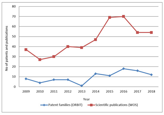
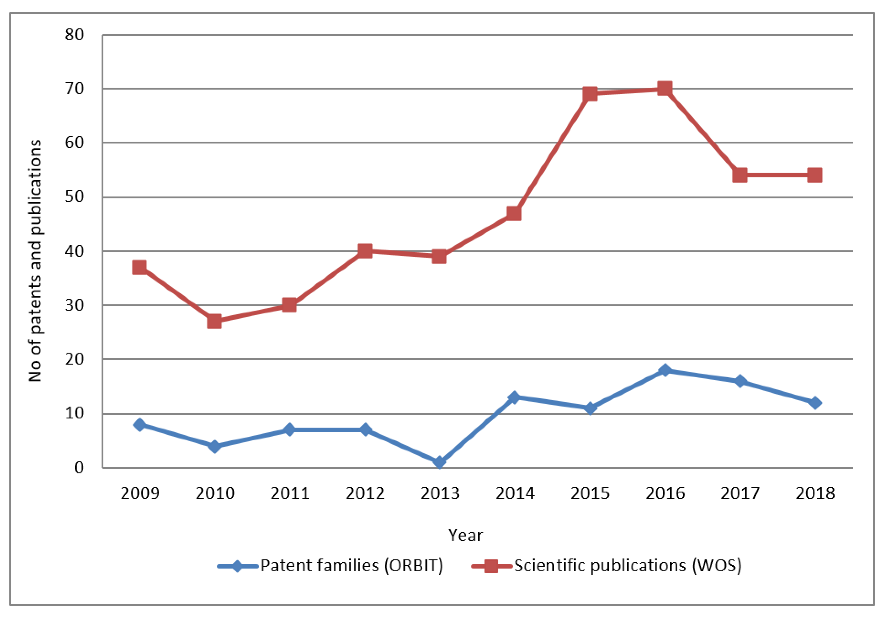
The first RQ aimed to analyse the patenting activity for airborne electromagnetic methods as well as to identify the main players. Analysing first the timeline of general patenting in the field of airborne electromagnetic methods over the last 10 years (Figure 1), a slight increase over the years can be seen (with a trough in 2013 and peaks in 2014 and 2016), with an average of 10 patents published each year since 2010. As for the evolution in scientific publications, we identify a similar development as in patenting, only slightly earlier, with a peak in the years 2015 and 2016. Contrary to the patent filing behaviour, a trough in 2013 is not detected.
Figure 1.
Publishing evolution. (Source: Questel Orbit Intelligence—Fampat Collection (Orbit) and Clarivative Web of Science—Core Collection (WOS)).
Second, the analysis of key players and patent portfolios shows the size of the patent applicants’ portfolios in the technology field and is an indicator of the level of inventiveness of the active players. The analysis not only presents the top applicants in the group of patents analysed, but also their legal status. This information makes it possible to identify applicants who have already withdrawn from the sector (abandonment, lapse, and/or expiration of their patents) and those who are still active (applications and patents granted and still in force).
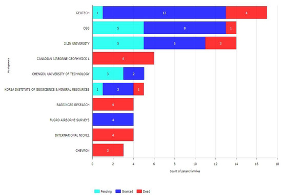
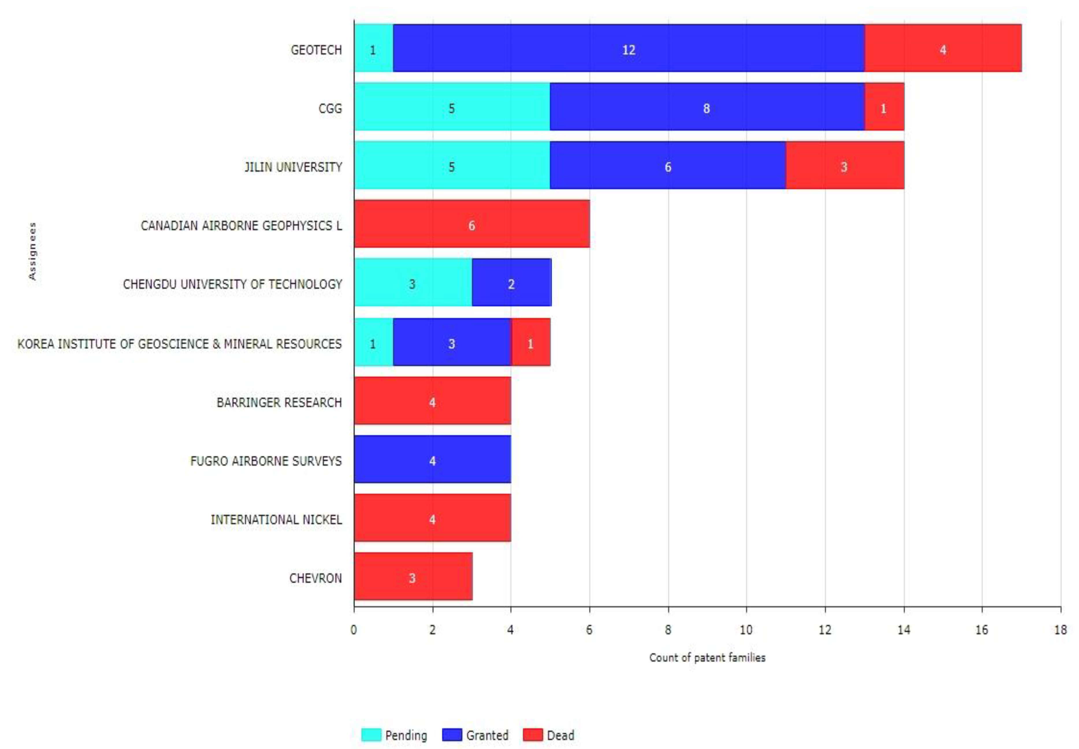
Regarding the top key players, the Canadian company Geotech is the leading company in patenting activity with a total of 17 patent applications, 12 of them granted and 1 pending, followed by the French geoscience company CGG, with 14 patent applications in total (8 of them granted and 5 pending), and the Dutch geo-data specialist Fugro, with 4 granted patents (Figure 2).
Figure 2.
Key players’ patents with legal status. (Source: Orbit).
As for public research institutions, the Chinese Jilin University leads with 14 patent applications in total (6 of them granted and 5 pending), followed by the Chinese Chengdu University of Technology (5 patent applications, 2 of them granted and 3 pending), and the Korean Institute of Geoscience & Mineral Resources, with 5 patent applications (3 of them granted and 1 pending). Both Chinese institutions have domestic patents only, i.e., their patents are not protected in other countries/jurisdictions.
In Appendix B, top patents of airborne electromagnetic methods are ordered by the number of citations received. Examples are stabilization systems for sensors on moving platforms, a helicopter electromagnetic prospecting system, and an airborne electromagnetic transmitter coil system, among others.
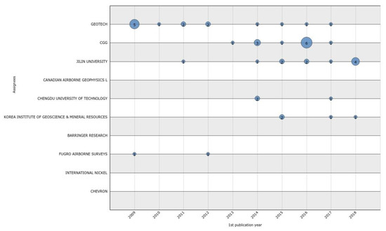
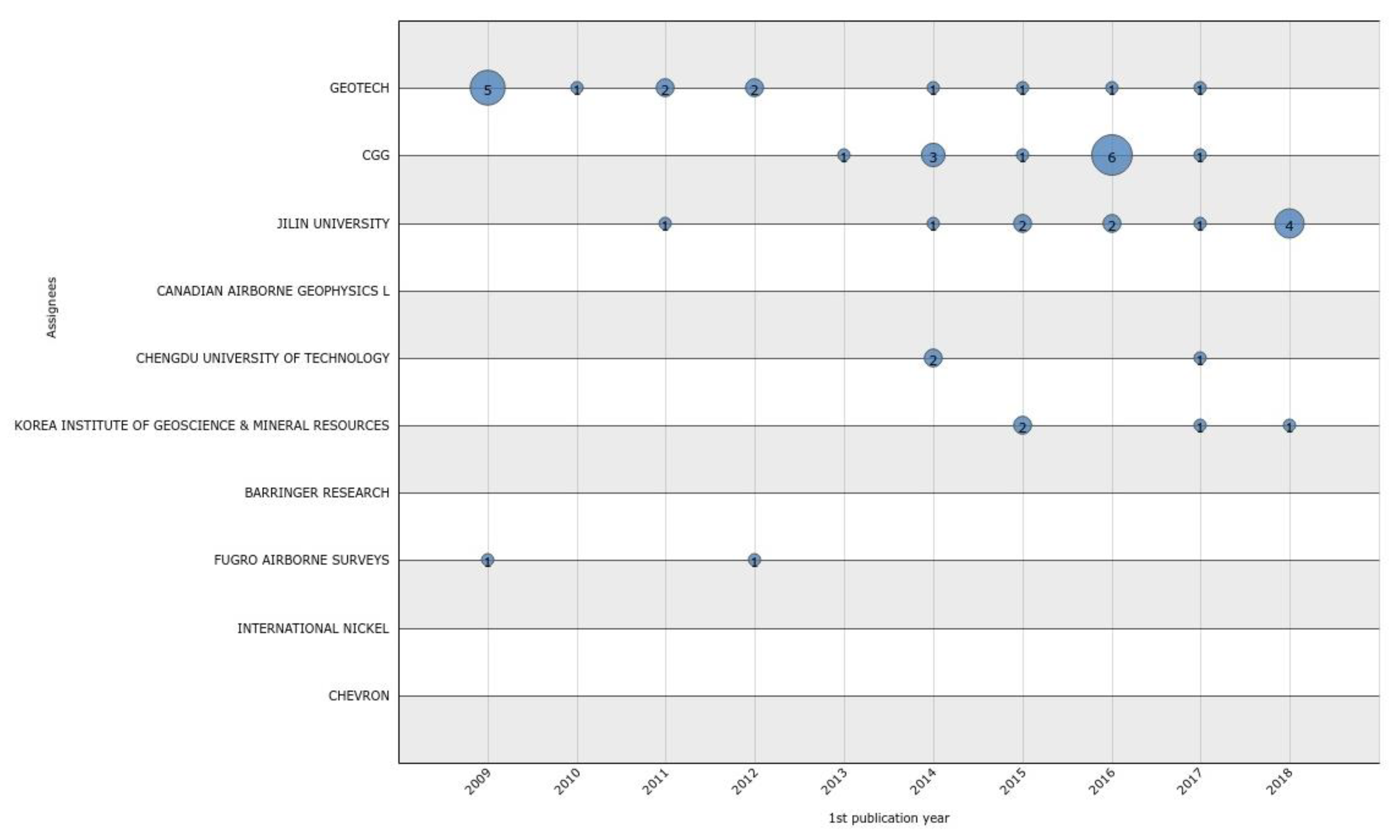
When looking at the patenting evolution of the top 10 main players over the last 20 years (Figure 3), we see that the Dutch Fugro patenting activity has stalled, with no patent published since 2012. Geotech and CGG have published patents in the field of airborne electromagnetic methods from 2013 until 2017, but nothing since then. The Asian research institutions (Jilin University, Chengdu University of Technology, and especially the Korean Institute of Geoscience) seem to be the players that have most recently generated innovations and protected them (2017–2019). The four remaining companies have no patents in the field of airborne electromagnetic methods published in the time period; this is because the patents in question are old (and in some cases the companies ceased to exist e.g., the Canadian company Airborne Geophysics Ltd.).
Figure 3.
Key players patenting evolution—patent families by 1st publication year. (Source: Orbit).
The analysis of the scientific output of the applicants shows the research effort in the technology field, by counting how many scientific publications have been published (articles and conference proceedings). This helps us to detect the organizations that are researching in the field.
Our analysis (Table 3) reveals that the Danish Aarhus University plays an important role, being the research institution that publishes the most in the field of airborne electromagnetic methods, followed by the Chinese Jilin University.
Table 3.
Key players in scientific publications with country of residence (see Appendix C for country code description) Source: WOS.
3.2. Innovation Origin and Markets
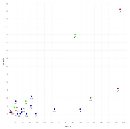
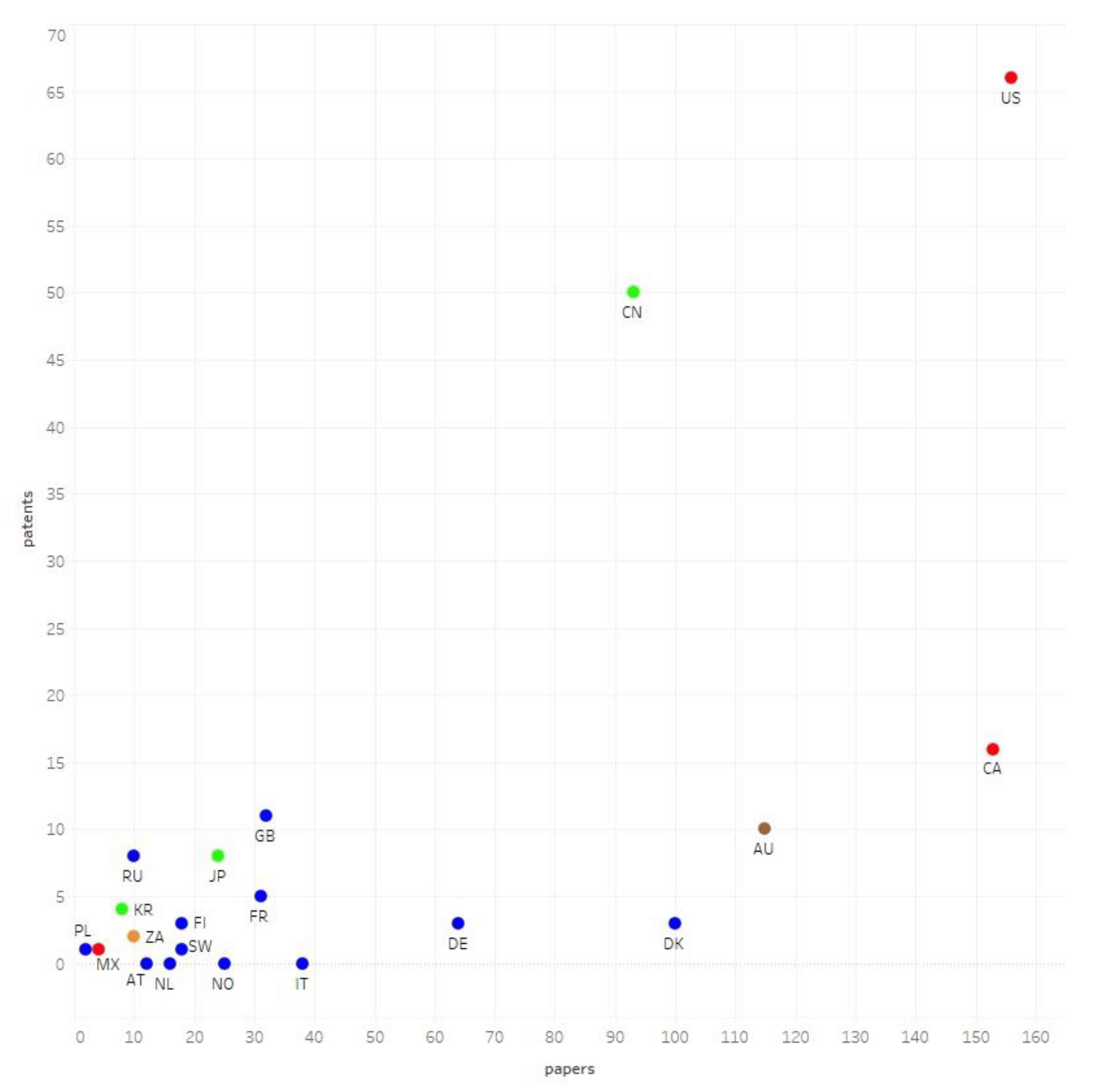
To assess RQ2, the innovation origin of patents and the countries where patent protection was sought most were analysed. The country where an invention is filed for the first time, the priority patent application, is usually the country where the inventor is residing and thus can be considered the innovation origin. When comparing the priority patent applications and the scientific publications (by country of residence of the corresponding authors’ institution) only China and the US show a considerable effort in both academic output and innovation via patents (Figure 4). Many other countries like Canada, Australia, Denmark, or Germany have a good academic presence, but not in patents. Comparing results by continents (marked in colours: red, Americas; blue, Europe; green, Asia; orange, Africa), the Americas have a leading position in both metrics, while in Europe, countries have only noteworthy results in scientific production.
Figure 4.
Geographic origin of patent and scientific publications (see Appendix C for country code description). Source: Orbit and WOS.
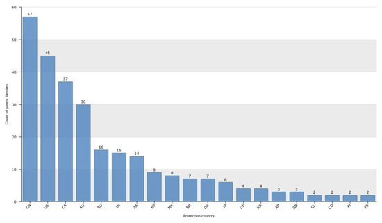
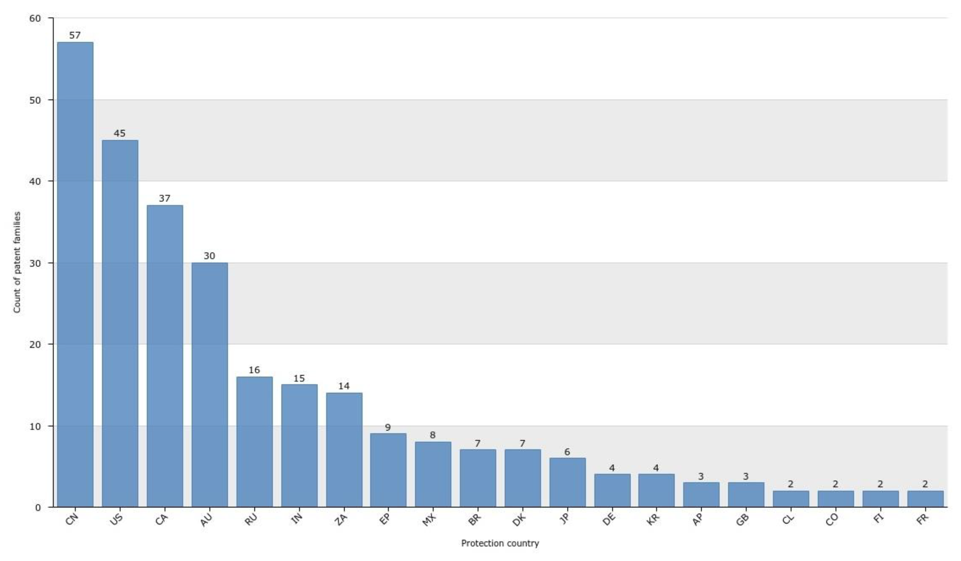
When analysing the countries where a patent filing is either pending or granted (“protection country”), we can identify the important markets, since the patent owner wants to protect its invention in these jurisdictions. Most patents related to airborne electromagnetic methods are currently pending or granted in China, the US, Canada, and Australia (Figure 5). Most of the Chinese pending or granted patents are domestic filings, meaning that the inventions are protected only in China.
Figure 5.
Jurisdictions with pending or granted patents. (Source: Orbit).
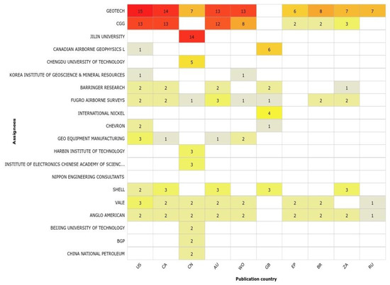
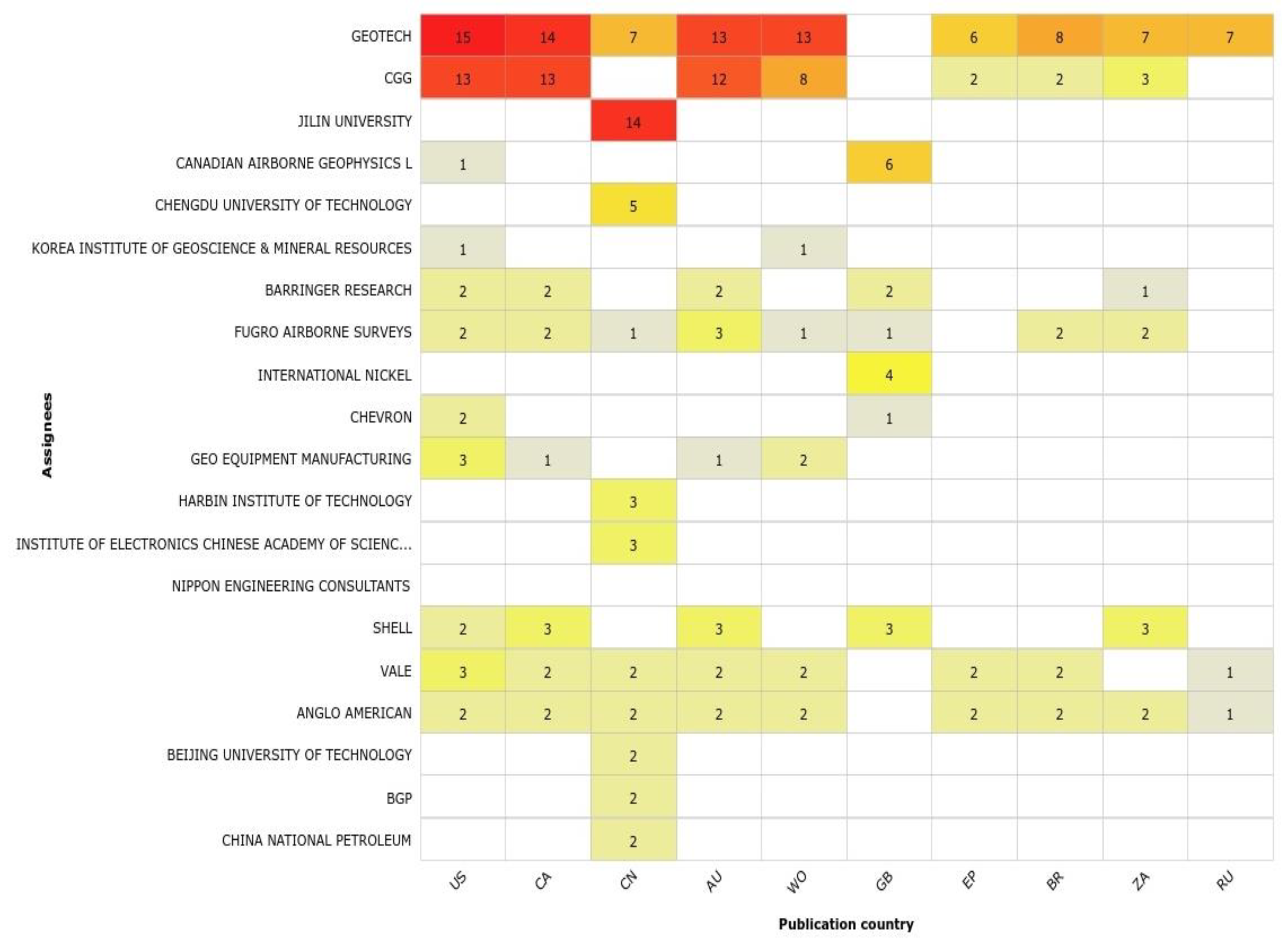
The next figure (Figure 6) visualizes the countries where most of the top applicants protect their inventions. Patent families with more than one member in a specific country will only be counted once for that country. However, you can find the same family in several portions of the chart if members of that family have been published in different countries or are co-owned. The intensity of the colour (heat graph) reflects the number of families in the intersection.
Figure 6.
Patent filing jurisdictions of applicants. (Source: Orbit).
It becomes evident that both Geotech and CGG have the most internationalised patent portfolio, with patent filings in 11 countries/patent jurisdictions.
3.3. Patent Citation and Collaboration
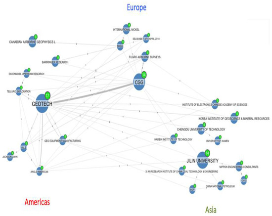
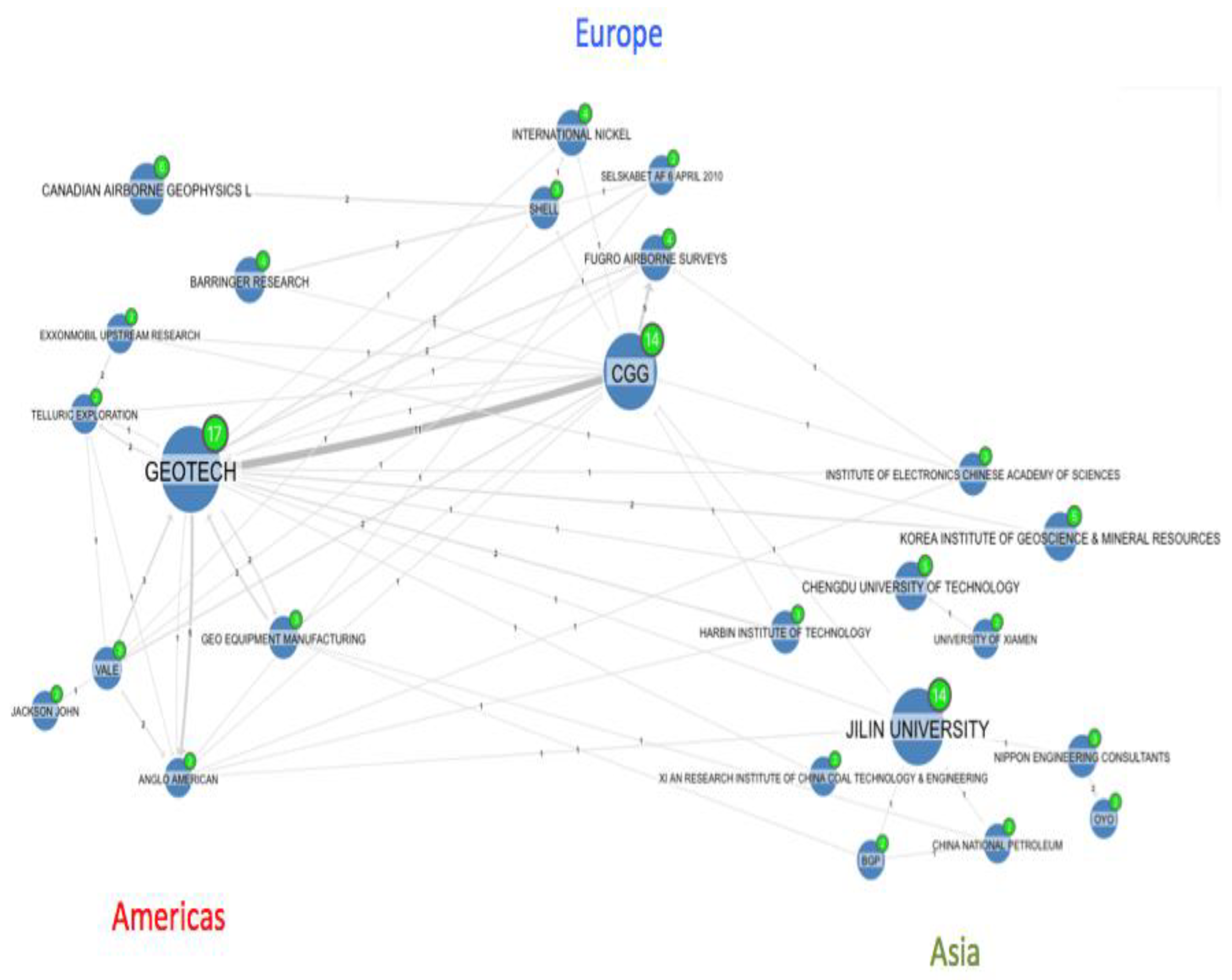
For the purpose of adding to the discussion of RQ3, which is the analysis of drivers for sustainable mineral exploration, patent citation maps were employed. Patent citation maps visualize connections via citations (the citation direction is visualized by an arrow). A portfolio that is strongly cited by most players is likely to be a pioneering or a blocking portfolio. Here, a strong relationship between patents from Geotech and CGG becomes evident, with 11 patents of CGG citing patents from Geotech. CGG and Fugro are also connected, with CGG citing 5 patents from Fugro’s portfolio (Figure 7). On a geographic scale, we can detect a fairly strong influence of the American players by European applicants, and to a lesser extent some citation connections between the Asian (mainly Chinese) and the American applicants.
Figure 7.
Patent citation of applicants (minimum 2 patents per applicant and minimum 1 citing patent). (Source: Orbit).
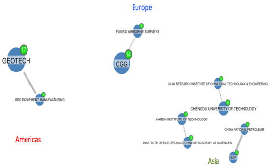
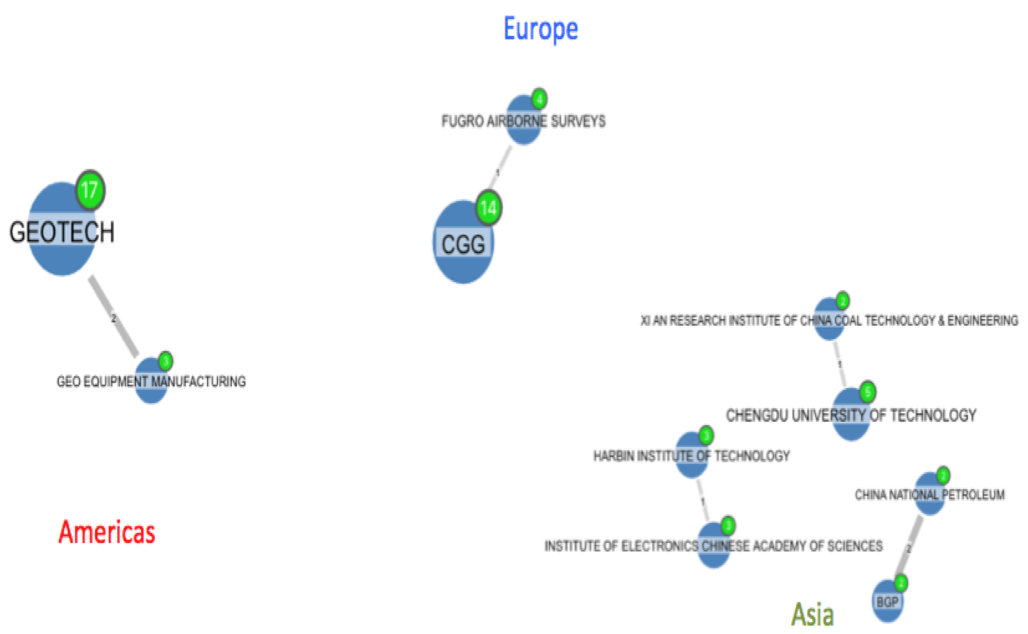
Patent collaboration maps visualise connections via co-authorship (inventorship) and reveal cooperation between applicants since they are co-filing a patent (co-authorship via line). In our field of study, few collaborations were detected; mostly only a single invention of the patent portfolios of the companies was co-authored with another company, and nearly all of the collaborations were between applicants of the same country, with the exception of the French CGG that co-authored one patent with the Dutch Fugro (Figure 8).
Figure 8.
Patent co-authorship of applicants (minimum 2 patents per applicant and minimum 1 patent in co-authorship). (Source: Orbit).
4. Discussion and Conclusions
Commencing with RQ1, the study asked how much technology is being patented and who the main players are. To do so, a total of 203 patent families and 772 scientific publications corresponding to the less invasive mining exploration technology of airborne electromagnetic exploration methods have been analysed. As patent analysis traditionally considers up to 10,000+, the technologies included in the selected KIT can be considered niche technologies [39]; we identified a total of 114,676 patent families in the mining exploration subsector filed between 1990 and 2015. Despite the difference in the period of analysis (25 years against 10 years in our research), mining patents have outpaced overall patenting activity since 2004, with patents for the technologies studied in this paper representing an order of magnitude of 10−3 compared to all patents retrieved in mining exploration.
In comparison, publication activity and patenting show similar trends, indicating a reinforcing pattern between the two. However, patenting levels are lower compared to publications. This is in line with previous technology watch reports, which show similar patterns [40]. The discrepancy is comparably high; an explanation for this discrepancy may be the transferability of the technologies into related sectors. Electromagnetic (EM) technologies can be found in industries as diverse as archaeology. When spillovers occur, there is often no additional patent filed but the application is discussed in scholarly articles.
In addition, and contrary to authors such as [41], the constant gap between patenting and publishing activity indicates that entrepreneurial activities do not jeopardize the scientific quality within the industry.
The top two players in patent filings are the Canadian company Geotech and the French geoscience company CGG (Figure 2), whereas the Danish Aarhus University followed by the Chinese Jilin University play the most important role publishing in the field of airborne electromagnetic methods. Identifying the key players can help practitioners identify key partners for future research projects and refine their search strategies to monitor innovations for sustainable exploration. Unsurprisingly, the named companies and universities are among the biggest players in their respective fields. Traditionally, the biggest players are equipped with the highest funding amounts, and higher risk capital. Sustainable technologies are often associated with high levels of uncertainty [42]. Diversification within a portfolio may reduce development risks. In turn, diversification is a variable favouring bigger companies and universities [42,43]. However once, sustainable technologies are mature, the growth stage may attract smaller companies to invest.
Comparing Figure 1 with traditional technology life cycle models, such as the Technology S-shape [44], the maturity levels of the technologies can be identified. By analysing the trend in Figure 1, it emerges that sustainable technologies in mineral exploration are currently on the verge of a growth phase. Numbers of patents and publications are growing, yet no stable trend is identifiable. This analysis is in line with Haupt et al. [45], who analysed patent indices as appropriate life cycle stage indicators. According to these authors. [45], growth and attention of sustainable technologies may only continue where the technologies demonstrate their value to the customer. This is especially the case for sustainable technologies, which come with a higher degree of uncertainty.
Concerning RQ2, the statistical country profiles yield information on patenting and scientific production behaviour across the globe. While the US has an indubitable leading position, China has also acquired a leading position in publication and patents. Indeed, the Chinese public research institution Jilin University seems to play an important role not only in relation to patent activity but also in terms of publishing productivity. However, the market potential of the patents must be further analysed, as they have received few citations and hence have low relevance. One of the reasons could be that they have been filed more recently (2017–2019). Moreover, the results from China show that patenting activity in one field may not serve as a proxy for sustainable development. Indeed, some authors [46,47] argue that the encouragement of research through the Chinese government (e.g., subsidy of patent fees and a lax examination policy of the Chinese patent office) is the biggest driver of China’s increased research actions. Consequently, the overall increase in Chinese patenting activities would require a comparison of the overall patenting increase and a share of less-invasive patenting.
Relating to RQ3, patent portfolio management and collaboration were analysed. Looking at collaboration and internationalisation of patent portfolios as drivers for sustainable technology development, a clear trend can be identified. The top two players, Geotech and CGG, both have the most internationalised patent portfolio (Figure 6). Thus, internationalisation of patent portfolios may be regarded as a driver for sustainable development. The patent citation and collaboration maps further highlight multiple network embeddedness of different key players, allowing for the identification of collaboration networks and ways to create knowledge spillovers. This is in line with Mulamula and Amadi-Echendu [48], who argues that technology spillover positively influences sustainable development. The co-citation analysis further shows that different players in the field of airborne electromagnetics are interconnected. When analysing the citation node maps (Figure 7), we detect the strongest interconnection between the Americas and Europe mainly due to the relationship of patents between CGG and Geotech. In addition, we observe that innovations spread timidly across value chain levels, meaning that not only do mineral–exploration-focused companies file patents, but so do mining companies; Anglo American and the Brazilian Vale were both included, with 2 patents each. Thus, a backward integration of companies can be identified as a driver for sustainable development.
Little collaboration is detected in the co-authorship map (Figure 8) and none is found among continents; therefore, results cannot support the notion that the industry is driven by global collaborative innovative abilities. Policy decisions towards incentivising global partnerships should be encouraged.
Summing up the findings regarding RQ3, it can be stated that there are three key drivers of sustainable development. (1) On a company level, internationalisation of patent portfolios is a driver for sustainable technology development. (2) Networking of different players within mineral exploration encourages patenting and increases transferability of know-how. Consequently, networking is a driver of economic sustainability. (3) Adding to the inter-industry perspective, the study found that players external to mineral exploration drive sustainable development.
Although this study has significant theoretical and practical implications, it has some limitations that can be subject to future research. Patent analysis search criteria have been combined in different approaches in the existing literature. While this paper pursues a combination of key words and classification schemes, other criteria combinations could be considered to identify new technological classes. Despite the multi-use nature of airborne electromagnetics, the INFACT-dictated search strategy might limit the generalisability to mineral exploration. Future research should focus on translating the search strategy into other industrial contexts. Here we suggest widening the approach by integrating different classification schemes or extending the search focus towards the four KITs selected by the experts. Moreover, the INFACT approach might be biased due to the common goal pursued in the project. To overcome this limitation, we considered different stakeholders from academia and industry as experts, who by their nature are driven by varying incentives. However, future research might consider a more diverse expert base.
Technology-watch activities are essential to systematically analyse and monitor new technology developments in the field of mineral exploration that could be tested and further developed. The present paper has analysed one of the four key intelligent technologies selected by INFACT partners. However, patent landscaping is a dynamic field, and hence frequent updates of this technology-watch exercise are recommended. To do so, the applied search strategy can be found in Appendix A, and the data sources used are mentioned in the methodology section. In future studies, other technologies reported by the survey respondents could be incorporated in the analysis.
Author Contributions
Conceptualization, S.R.-C. and B.J.; methodology, S.R.-C., B.J. and V.H.-S.; software, B.J. and V.H.-S.; validation, S.R.-C., M.K. and V.H.-S.; formal analysis, S.R.-C., B.J. and V.H.-S.; investigation, S.R.-C. and M.K.; resources, M.K.; data curation, B.J.; writing—original draft preparation, S.R.-C. and B.J.; writing—review and editing, S.R.-C. and M.K.; visualization, B.J. and V.H.-S.; supervision, S.R.-C.; project administration, S.R.-C.; funding acquisition, S.R.-C. and V.H.-S. All authors have read and agreed to the published version of the manuscript.
Funding
This research has received funding from the European Union’s Horizon 2020 research and innovation programme under grant agreement nº 776487. Furthermore, some of the authors (B.J. and V.H.-S.) were supported by the Spanish Ministry of Science Innovation and Universities under the framework of the R&D project RTI2018-098966-B-I00.
Acknowledgments
The authors gratefully acknowledge the contribution of participating partners on the INFACT project grant agreement No 776487 and especially those from Richard Gloaguen, Leila Ajjabou and Moritz Kirsch.
Conflicts of Interest
The authors declare no conflict of interest.
Appendix A
Search strategy:
| Keywords concept 1 (TI/AB/CLMS) | AERIAL OR AERO OR AIRBORNE OR AIRCRAFT OR AIRPLANE OR AIRSHIP OR AVIATION OR HELICOPTER |
| Keywords concept 2 (TI/AB/CLMS) | ELECTROMAGNETIC+ |
| Keywords Concept 3 (TI/AB/CLMS) | SURVEY+ OR MAPPING OR PROSPECT+ OR EXPLOR+ |
| Patent class CPC & IPC | G01V3 Electric or magnetic prospecting or detecting |
| ORBIT query (for patent retrieval) | ((AERIAL OR AERO OR AIRBORNE OR AIRCRAFT OR AIRPLANE OR AIRSHIP OR AVIATION OR HELICOPTER)/TI/AB AND (ELECTROMAGNETIC+)/TI/AB/CLMS AND (SURVEY+ OR MAPPING OR PROSPECT+ OR EXPLOR+)/TI/AB/CLMS) AND (G01V-003)/IPC/CPC |
| Results (patent families, ORBIT) | 203 |
| WOS query (for scientific publications retrieval) | TOPIC: (AERIAL OR AERO* OR AIRBORNE OR AIRCRAFT OR AIRPLANE OR AIRSHIP OR AVIATION OR HELICOPTER) AND TOPIC: (ELECTROMAGNETIC*) AND TOPIC: (SURVEY* OR MAPPING OR PROSPECT* OR EXPLOR*) Refined by: WEB OF SCIENCE CATEGORIES: (GEOCHEMISTRY GEOPHYSICS OR GEOSCIENCES MULTIDISCIPLINARY OR REMOTE SENSING) Timespan: All years. Indexes: SCI-EXPANDED, SSCI, A&HCI, CPCI-S, CPCI-SSH, BKCI-S, BKCI-SSH, ESCI, CCR-EXPANDED, IC. |
| Results (scientific publications, WOS core) | 772 |
Appendix B
Airborne electromagnetic methods top patents ordered by the number of citations received
| Title & Applicant | Abstract | Image |
| Stabilization system for sensors on moving platforms Applicant: VALE | A stabilized field sensor apparatus that collects field data, in particular magnetic field data, with reduced motion noise. The apparatus includes: tear drop shaped housing, tow frame in the housing, a plurality of vibration isolating dampers spaced around the frame, a base assembly mounted to the dampers, a support pedestal having a bottom end fixed to the base assembly and an upper free end, a single spherical air bearing connected to the upper free end of the pedestal, an instrument platform with a lower hollow funnel having an upper inside apex supported on the air bearing for a one point support, principal and secondary gyro stabilizers for maintaining pivotal and rotational stability, and at least one field sensor mounted to the instrument platform for collecting the field data while being stabilized against motion noise including vibration, pivoting and rotation from the base assembly, from the tow frame and from the housing. | no image available |
| Helicopter electromagnetic prospecting system Applicant: ANGLO AMERICAN | An airborne electromagnetic prospecting system (10) is disclosed. The system (10) comprises a transmitter loop structure (12) that is attached to, and arranged to be towed by, a helicopter (14). A transmitter (22) is fitted to the transmitter loop structure (12) for transmitting a primary electromagnetic field. A high drag bird (26) is attached to, and arranged to be towed by, the transmitter loop structure (12). A receiver (38) is fitted to the high drag bird (26) for receiving a primary and secondary resulting electromagnetic field, the secondary field arising from the interaction of the primary field with ground conductors that are traversed by the helicopter (14). Significantly, the high drag bird (26) is also attached to, and arranged to be towed by, the helicopter (14), so as to keep the position of the receiver (38) relative to the transmitter (22) substantially constant. | 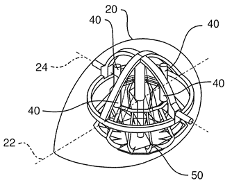 |
| Receiver coil assembly for airborne geophysical surveying with noise mitigation Applicant: GEOTECH | An airborne geophysical surveying system comprising a receiver coil assembly for towing by an aircraft, the receiver assembly including a receiver coil for sensing changes in a magnetic field component of a magnetic field, and a receiver coil orientation sensing system for sensing orientation changes of the receiver coil. A controller receives signals representing the sensed changes in the magnetic field component from the receiver coil and the sensed orientation changes from the receiver coil orientation sensing system and corrects the sensed changes in the magnetic field component to provide a signal that is corrected for noise caused by changing orientation of the receiver coil in a static geomagnetic field. | 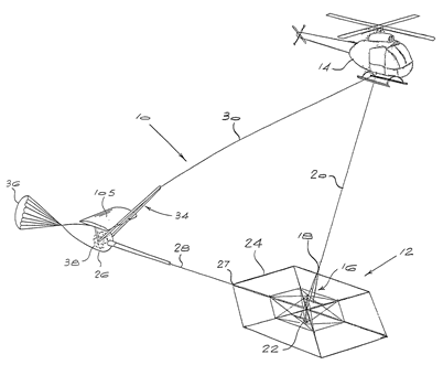 |
| Airborne electromagnetic transmitter coil system Applicant: GEOTECH | A tow assembly for an airborne electromagnetic surveying system comprising a semi-rigid transmitter coil frame supporting a transmitter coil, the transmitter coil frame being formed from a plurality of serially connected frame sections forming a loop, the transmitter coil frame having articulating joints at a plurality of locations about a circumference thereof enabling the transmitter coil frame to at least partially bend at the articulating joints, and a suspension assembly for towing the transmitter coil frame behind an aircraft, the suspension assembly comprising a plurality of ropes and attached to the circumference of the transmitter coil frame at spaced apart locations. | 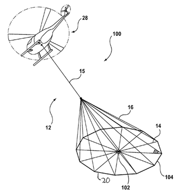 |
| Airborne electromagnetic time domain system, computer product, and method Applicant: GEOTECH | An airborne time domain electromagnetic surveying system is provided. The system includes a tow assembly with a flexible support frame. The flexible support frame spaced apart from the aircraft includes a transmitter section with a transmitter loop and a receiver section with a sensor aligned with the central axis of the transmitter section. The flexible support frame has a lightweight modular structure that enables the surface area of the transmitter section to be increased and decreased to suit particular survey applications. The transmitter loop sends a pulse in an “ON” interval, and in an “OFF” interval the sensor measures the earth response to the pulse. The tow assembly also includes a sensor for generating selected survey data in the “ON” interval. A transmitter driver enables the creation of an earthbound pulse. The system components are linked to a computer and control computer program linked thereto for controlling the functions thereof. The invention also includes a method for producing survey data using the tow assembly of the invention. | 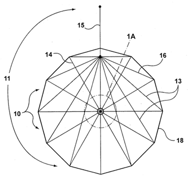 |
| Tow assembly for fixed wing aircraft for geophysical surveying Applicant: GEOTECH | An airborne geophysical electromagnetic (EM) survey tow assembly system for use with a fixed wing aircraft, including: receiver coil assembly comprising a substantially rigid tubular receiver coil frame forming a continuous internal passageway that extends around a central open area, and a receiver coil housed within the internal passageway; a winch system having a tow cable secured to the receiver coil assembly for extending the receiver coil assembly into a survey position; and a latch system for mounting to an underside of the aircraft having releasable latch members for engaging the receiver coil assembly when the receiver coil assembly is in a retracted position. | 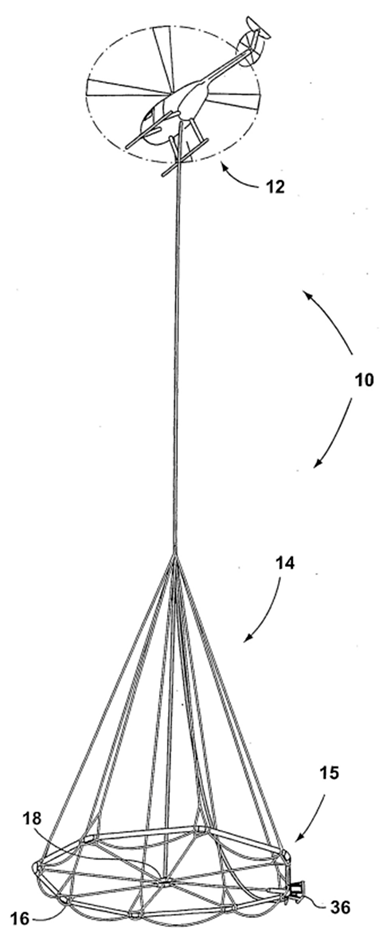 |
| Airborne electromagnetic system Applicant: ANGLO AMERICAN | A towed aircraft for use in an airborne electromagnetic geophysical prospecting system includes a transmitting antenna (34) and power generating means (24) for powering the antenna. A bird (72) (Figure 4) to which is mounted a receiving antenna (58) may be towed by the towed aircraft. | 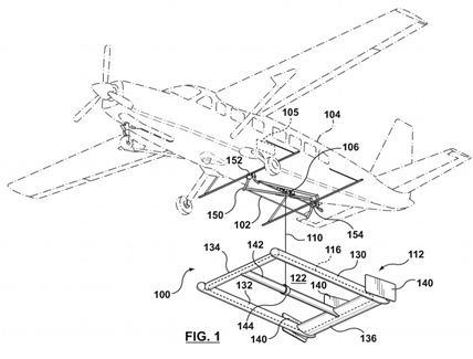 |
| Double-suspension receiver coil system and apparatus Applicant: GEOTECH | A receiver coil apparatus for an electromagnetic survey system, comprising: a tubular outer frame defining an internal passage; a rigid inner member; a receiver coil; a plurality of first elastic suspension members suspending the receiver coil from the rigid inner member within the internal passage; and a plurality of second elastic suspension members suspending the rigid inner member within the internal passage. | 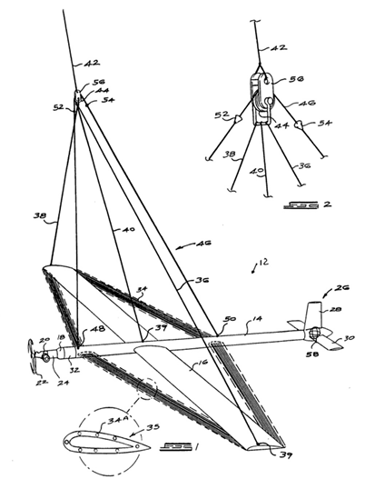 |
| Bucking circuit for annulling a magnetic field Applicant: VALE | A method and apparatus is provided for bucking a magnetic field of known geometry and time variation by means of a plurality of bucking loops. It utilizes multiple loops, each of which is energized by an electric current that creates a magnetic field of the known time variation. The multi-loop field forms a bucking magnetic field that better opposes the spatial variation in the known magnetic field over a volume than can the magnetic field from a single loop. The present invention is useful in electromagnetic measurements, where the magnetic field of a controlled source transmitter must be annulled at a magnetic field sensor. It is particularly useful for cases where the magnetic sensor may move relative to the transmitter, such as in certain airborne electromagnetic measurements. | 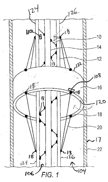 |
Appendix C
Codes for Countries and Patent Offices
| Code | Country |
| AP | African Regional IP Organization |
| AT | Austria |
| AU | Australia |
| BR | Brazil |
| CA | Canada |
| CL | Chile |
| CN | China |
| CO | Colombia |
| DE | Germany |
| DK | Denmark |
| EP | European Patent Office |
| FI | Finland |
| FR | France |
| GB | United Kingdom |
| IN | India |
| IT | Italy |
| JP | Japan |
| KR | Korea (South) |
| MX | Mexico |
| NL | Netherlands |
| PL | Poland |
| RU | Russian Federation |
| SW | Sweden |
| US | United States of America |
| ZA | South Africa |
References
- Inigo, E.A. Sustainable innovation: Creating solutions for sustainable development. In Decent Work and Economic Growth. Encyclopedia of the UN Sustainable Development Goals; Leal Filho, W., Azul, A., Brandli, L., Özuyar, P., Wall, T., Eds.; Springer: Cham, Switzerland, 2019. [Google Scholar] [CrossRef] [Scilit]
- Baughey, K. Functional and Logical Structures: A Systems Engineering Approach (No. 2011-01-0517); SAE Technical Paper; SAE International: Warrendale, PA, USA, 2011. [Google Scholar] [CrossRef] [Scilit]
- Mudd, G.M. The environmental sustainability of mining in Australia: Key mega-trends and looming constraints. Resour. Policy 2010, 35, 98–115. [Google Scholar] [CrossRef] [Scilit]
- Gloaguen, R.; Ghamisi, P.; Lorenz, S.; Kirsch, M.; Zimmermann, R.; Booysen, R.; Andreani, L.; Jackisch, R.; Hermann, E.; Tusa, L.; et al. The Need for Multi-Source, Multi-Scale Hyperspectral Imaging to Boost Non-Invasive Mineral Exploration. In Proceedings of the InIGARSS 2018–2018 IEEE International Geoscience and Remote Sensing Symposium, Valencia, Spain, 22–27 July 2018; Volume 22, pp. 7430–7433. [Google Scholar] [CrossRef] [Scilit]
- UN General Assembly. Transforming our World: The 2030 Agenda for Sustainable Development, 21 October 2015, A/RES/70/1. Available online: https://www.un.org/en/development/desa/population/migration/generalassembly/docs/globalcompact/A_RES_70_1_E.pdf (accessed on 17 November 2020).
- Pour, S.H.; Wahab, A.K.A.; Shahid, S.; Asaduzzaman, M.; Dewan, A. Low impact development techniques to mitigate the impacts of climate-change-induced urban floods: Current trends, issues and challenges. Sustain. Cities Soc. 2020, 62, 102373. [Google Scholar] [CrossRef] [Scilit]
- Ferreira, J.J.M.; Fernandes, C.I.; Ferreira, F.A.F. Technology transfer, climate change mitigation, and environmental patent impact on sustainability and economic growth: A comparison of European countries. Technol. Forecast. Soc. Chang. 2020, 150, 119770. [Google Scholar] [CrossRef] [Scilit]
- Fu, B.; Wang, S.; Zhang, J.; Hou, Z.; Li, J. Unravelling the complexity in achieving the 17 sustainable-development goals. Natl. Sci. Rev. 2019, 6, 386–388. [Google Scholar] [CrossRef] [Scilit]
- UNDP; IFC; IPIECA; CCSI. Mapping the Oil and Gas Industry to the Sustainable Development Goals: An Atlas. 2017. Available online: https://www.undp.org/content/undp/en/home/librarypage/poverty-reduction/mapping-the-oil-and-gas-industry-to-the-sdgs--an-atlas.html (accessed on 17 November 2020).
- Krajčo, K.; Habánik, J.; Grenčíková, A. New technology impact on the Sustainable Development. Eng. Econ. 2019, 30. [Google Scholar] [CrossRef] [Scilit]
- Spangenberg, J.H.; Fuad-Luke, A.; Blincoe, K. Design for Sustainability (DfS): The interface of sustainable production and consumption. J. Clean. Prod. 2010, 18, 1485–1493. [Google Scholar] [CrossRef] [Scilit]
- NEXT New Exploration Techniques. Available online: https://www.new-exploration.tech/ (accessed on 23 September 2020).
- Smart Exploration Project. Available online: https://smartexploration.eu/ (accessed on 23 September 2020).
- PACIFIC Project. Available online: https://www.pacific-h2020.eu/ (accessed on 23 September 2020).
- INFACT Project. Available online: https://www.infactproject.eu/ (accessed on 6 February 2020).
- Hilson, G.; Murck, B. Sustainable development in the mining industry: Clarifying the corporate perspective. Resour. Policy 2000, 26, 227–238. [Google Scholar] [CrossRef] [Scilit]
- Ali, S.; Giurco, D.; Arndt, N.; Nickless, E.; Brown, G.; Demetriades, A.; Durrheim, R.; Enriquez, M.A.; Kinnaird, J.; Littleboy, A.; et al. Mineral supply for sustainable development requires resource governance. Nature 2017, 543, 367–372. [Google Scholar] [CrossRef] [Scilit]
- Azapagic, A. Developing a framework for sustainable development indicators for the mining and minerals industry. J. Clean. Prod. 2004, 12, 639–662. [Google Scholar] [CrossRef] [Scilit]
- Caron, J.; Durand, S.; Asselin, H. Principles and criteria of sustainable development for the mineral exploration industry. J. Clean. Prod. 2011, 119, 215–222. [Google Scholar] [CrossRef] [Scilit]
- Kesselring, M.; Wagner, F.; Kirsch, M.; Ajjabou, L.; Gloaguen, R. Sustainable test sites for mineral exploration: Development of sustainable test sites and knowledge spillover for industry. Sustainability 2020, 12, 2016. [Google Scholar] [CrossRef] [Scilit]
- Abraham, B.P.; Moitra, S.D. Innovation assessment through patent analysis. Technovation 2001, 21, 245–252. [Google Scholar] [CrossRef] [Scilit]
- Fleisher, C.S. Should the field be called competitive intelligence or something else? In Controversies in Competitive Intelligence: The Enduring Issues; Praeger: Westport, CT, USA, 2003; pp. 56–69. ISBN 1-56720-560-7. [Google Scholar]
- Negash, S. Business Intelligence. Commun. Assoc. Inf. Syst. 2004, 13, 77–195. [Google Scholar] [CrossRef] [Scilit]
- Herring, J.P. Key intelligence topics: A process to identify and define intelligence needs. In Competitive Intelligence Review: Published in Cooperation with the Society of Competitive Intelligence Professionals; Wiley: Hoboken, NJ, USA, 1999; Volume 10, pp. 4–14. [Google Scholar] [CrossRef]
- Witherly, K.; Irvine, R.; Morrison, E. The geotech VTEM time domain helicopter em system. ASEG Ext. Abstr. 2004, 1–4. [Google Scholar] [CrossRef] [Scilit]
- Sørense, K.I.; Auken, E. SkyTEM—A new high-resolution helicopter transient electromagnetic system. Explor. Geophys. 2004, 35, 194–202. [Google Scholar] [CrossRef] [Scilit]
- Sattel, D. An overview of Helicopter Time-Domain EM systems. ASEG Ext. Abstr. 2009, 1–7. [Google Scholar] [CrossRef] [Scilit]
- Dentith, M.; Mudge, S.T. Geophysics for the Mineral Exploration Geoscientist; Cambridge University Press: Cambridge, UK, 2014; p. 454. ISBN 10 0521809517. [Google Scholar]
- Legault, J.M. Airborne Electromagnetic Systems-State of the Art and Future Directions: CSEG Recorder. 2015, pp. 38–49. Available online: https://csegrecorder.com/articles/view/airborne-electromagnetic-systems-state-of-the-art-and-future-directions (accessed on 15 May 2020).
- Jürgens, B.; Herrero-Solana, V. Espacenet, Patentscope and Depatisnet: A comparison approach. World Pat. Inf. 2015, 42, 4–12. [Google Scholar] [CrossRef] [Scilit]
- Zhou, Y.; Pan, M.; Urban, F. Comparing the international knowledge flow of China’s wind and solar photovoltaic (PV) industries: Patent analysis and implications for sustainable development. Sustainability 2018, 10, 1883. [Google Scholar] [CrossRef] [Scilit]
- Albino, V.; Ardito, L.; Dangelico, R.M.; Petruzzelli, A.M. Understanding the development trends of low-carbon energy technologies: A patent analysis. Appl. Energy 2014, 135, 836–854. [Google Scholar] [CrossRef] [Scilit]
- Orbit Intelligence. Available online: https://www.orbit.com/ (accessed on 23 September 2020).
- Clarivative Web of Science. Available online: https://clarivate.com/webofsciencegroup/solutions/web-of-science/ (accessed on 23 September 2020).
- Choi, J.; Hwang, Y.S. Patent keyword network analysis for improving technology development efficiency. Technol. Forecast. Soc. Chang. 2014, 83, 170–182. [Google Scholar] [CrossRef] [Scilit]
- Daim, T.U.; Rueda, G.; Martin, H.; Gerdsri, P. Forecasting emerging technologies: Use of bibliometrics and patent analysis. Technol. Forecast. Soc. Chang. 2006, 73, 981–1012. [Google Scholar] [CrossRef] [Scilit]
- Liu, S.J.; Shyu, J. Strategic planning for technology development with patent analysis. Int. J. Technol. Manag. 1997, 13, 661–680. [Google Scholar] [CrossRef] [Scilit]
- Abbas, A.; Zhang, L.; Khan, S.U. A literature review on the state-of-the-art in patent analysis. World Pat. Inf. 2014, 37, 3–13. [Google Scholar] [CrossRef] [Scilit]
- Daly, A.; Valacchi, G.; Raffo, J. Mining Patent Data: Measuring Innovation in the Mining Industry with Patents. Economic Research Working Paper No. 56. WIPO. 2019. Available online: https://www.wipo.int/edocs/pubdocs/en/wipo_pub_econstat_wp_56.pdf (accessed on 23 September 2020).
- Zhou, X.; Zhang, Y.; Porter, A.L.; Guo, Y.; Zhu, D. A patent analysis method to trace technology evolutionary pathways. Scientometrics 2016, 100, 705–721. [Google Scholar] [CrossRef] [Scilit]
- Van Looy, B.; Callaert, J.; Debackere, K. Publication and patent behavior of academic researchers: Conflicting, reinforcing or merely co-existing? Res. Policy 2006, 35, 596–608. [Google Scholar] [CrossRef] [Scilit]
- Kitzing, L.; Fitch-Roy, O.; Islam, M.; Mitchell, C. An evolving risk perspective for policy instrument choice in sustainability transitions. Environ. Innov. Soc. Transit. 2018, 18. [Google Scholar] [CrossRef] [Scilit]
- Meijer, L.L.J.; Huijben, J.C.C.M.; Van Boxstael, A.; Romme, A.G.L. Barriers and drivers for technology commercialization by SMEs in the Dutch sustainable energy sector. Renew. Sustain. Energy Rev. 2019, 112, 114–126. [Google Scholar] [CrossRef] [Scilit]
- Andersen, B. The hunt for S-shaped growth paths in technological innovation: A patent study. J. Evol. Econ. 1999, 9, 487–526. [Google Scholar] [CrossRef] [Scilit]
- Haupt, R.; Kloyer, M.; Lange, M. Patent indicators for the technology life cycle development. Res. Policy 2007, 36, 387–398. [Google Scholar] [CrossRef] [Scilit]
- Eberhardt, M.; Helmers, C.; Yu, Z. What can explain the Chinese patent explosion? Oxf. Econ. Pap. 2017, 69, 239–262. [Google Scholar] [CrossRef] [Scilit]
- Long, C.X.; Wang, J. Evaluating patent promotion policies in China: Consequences for patent quantity and quality. In Economic Impacts of Intellectual Property-Conditioned Government Incentives; Springer: Singapore, 2016; pp. 235–257. [Google Scholar] [CrossRef] [Scilit]
- Mulamula, G.; Amadi-Echendu, J. An examination of the potential links between ICT technology transfer and sustainable development. Int. J. Technol. Manag. Sustain. Dev. 2017, 16, 119–139. [Google Scholar] [CrossRef] [Scilit]

Publisher’s Note: MDPI stays neutral with regard to jurisdictional claims in published maps and institutional affiliations. |
© 2020 by the authors. Licensee MDPI, Basel, Switzerland. This article is an open access article distributed under the terms and conditions of the Creative Commons Attribution (CC BY) license (http://creativecommons.org/licenses/by/4.0/).