Spatiotemporal Characteristics of Near-Surface Wind in Shenzhen


 ,
,  ,
,
Abstract
1. Introduction
2. Materials and Methods
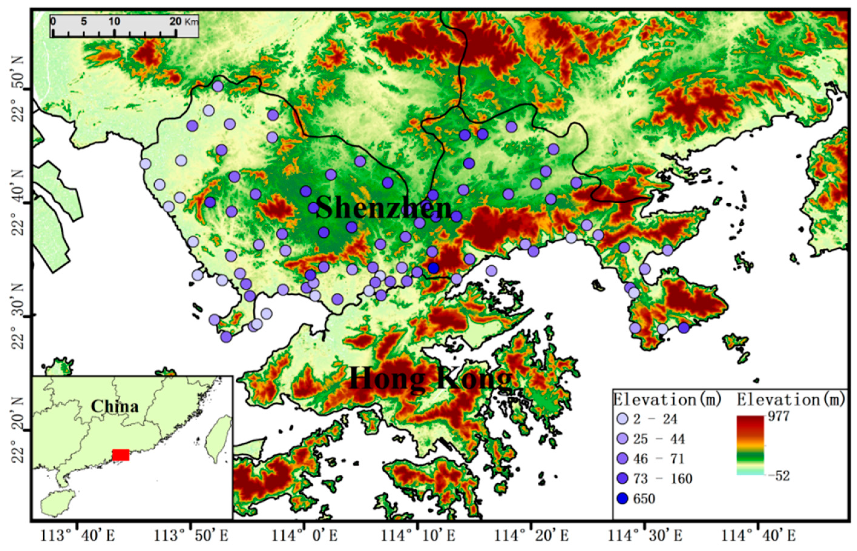
2.1. Study Area and Data
2.2. Methods
2.2.1. Empirical Orthogonal Function (EOF) Analysis
2.2.2. Gust Factor
2.2.3. Trend Analysis
2.2.4. Mean Direction
3. Results and Discussion
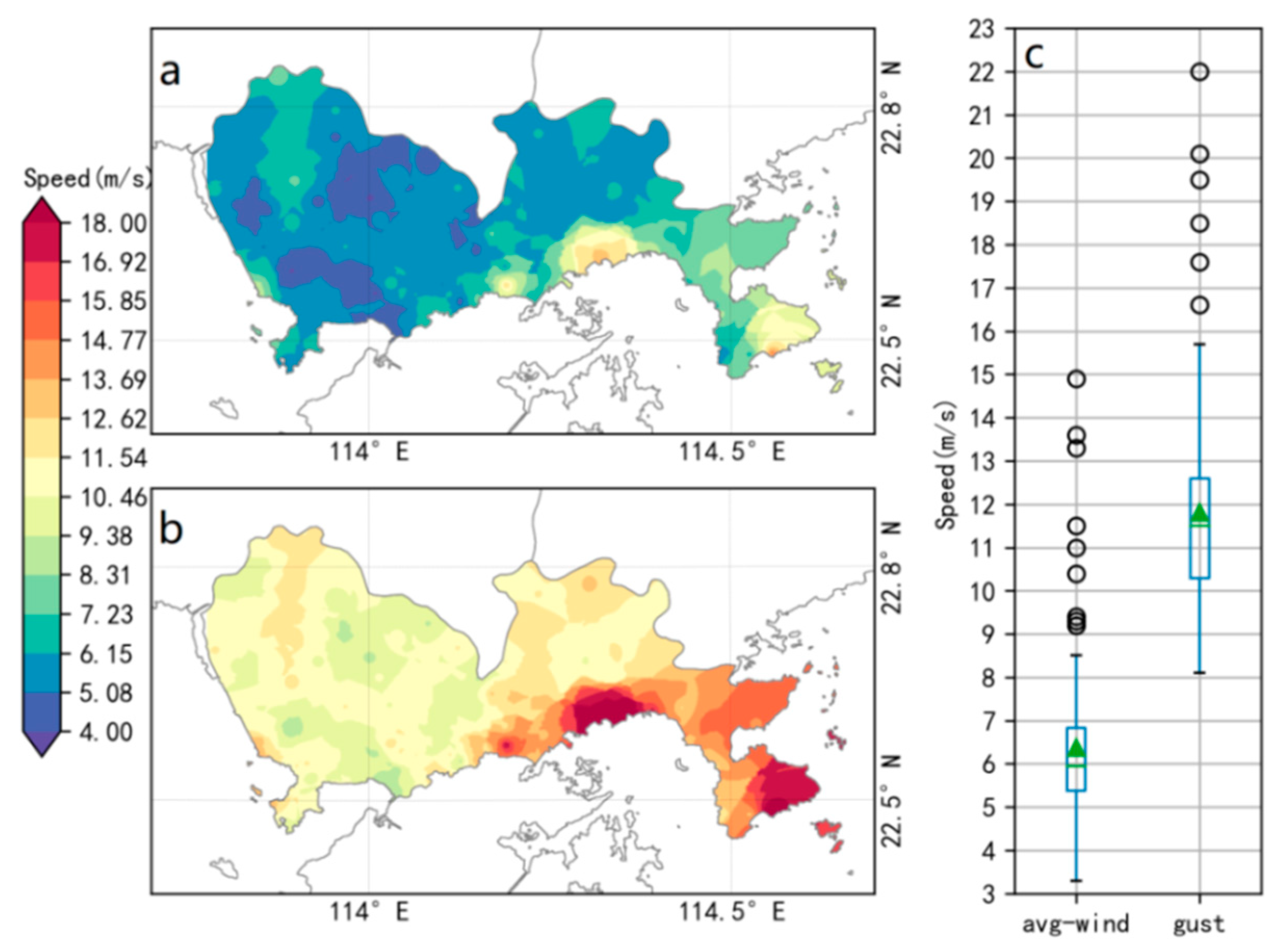
3.1. Spatial Wind Characteristics
3.2. Spatiotemporal Wind Characteristics
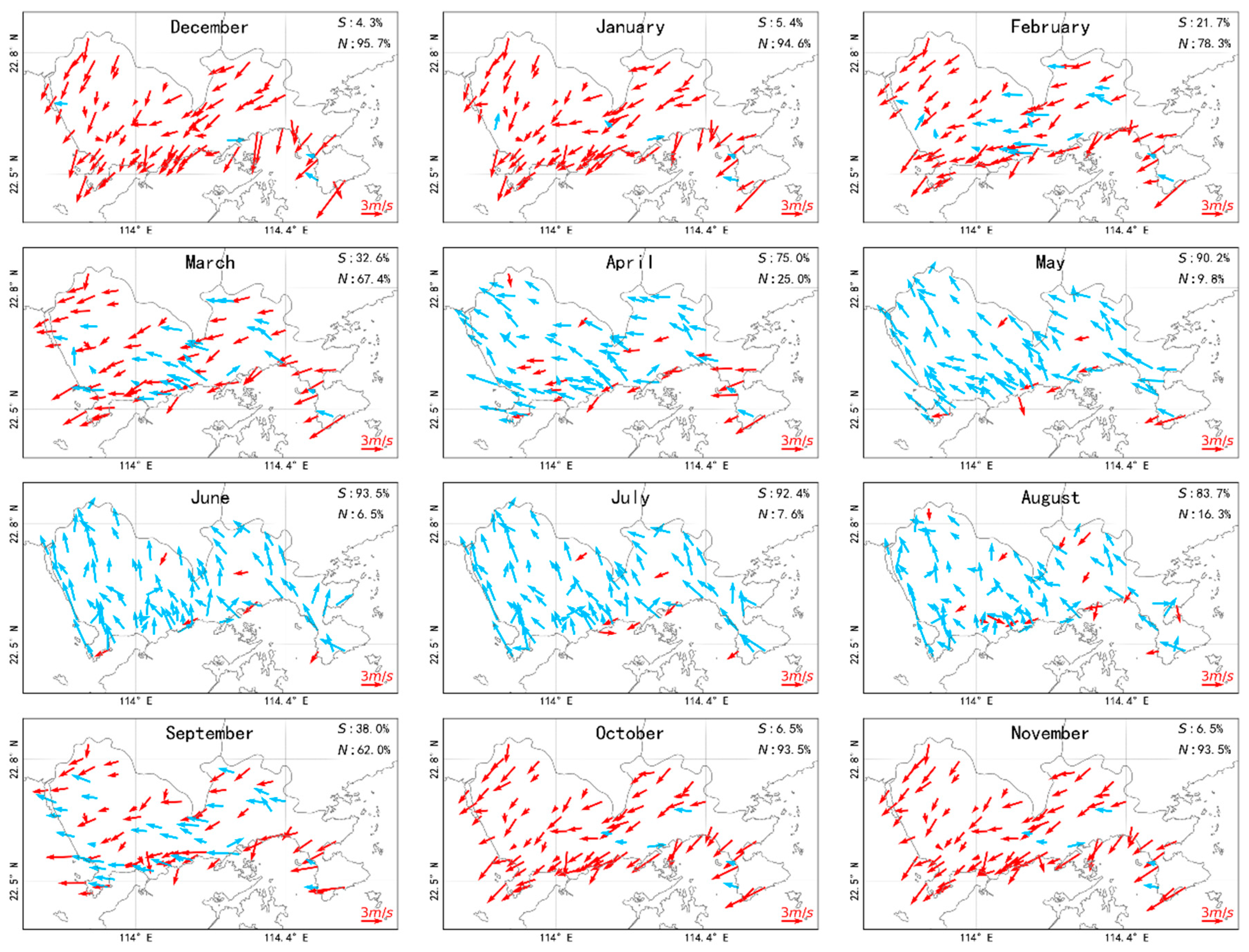
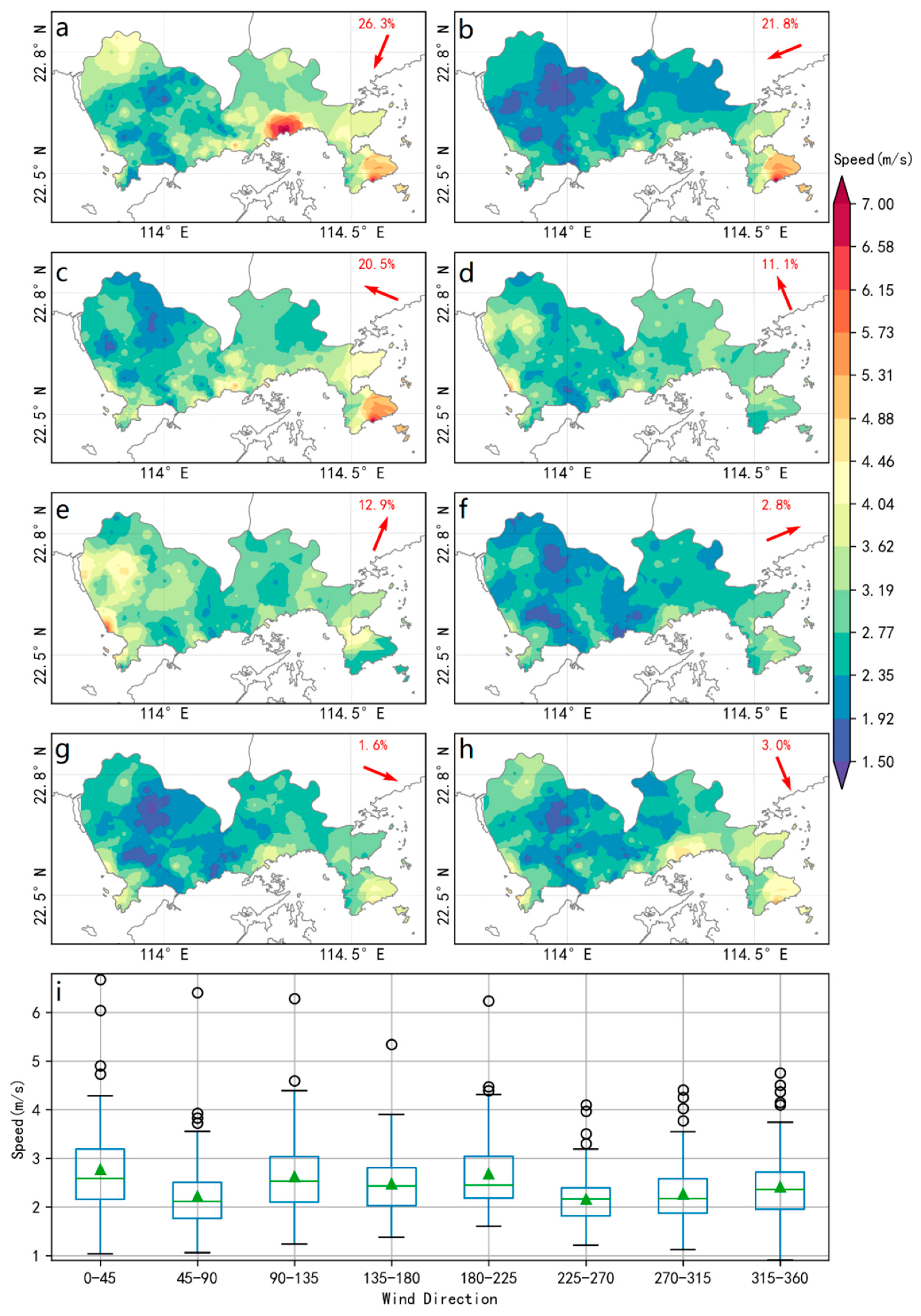
3.2.1. Monthly Wind
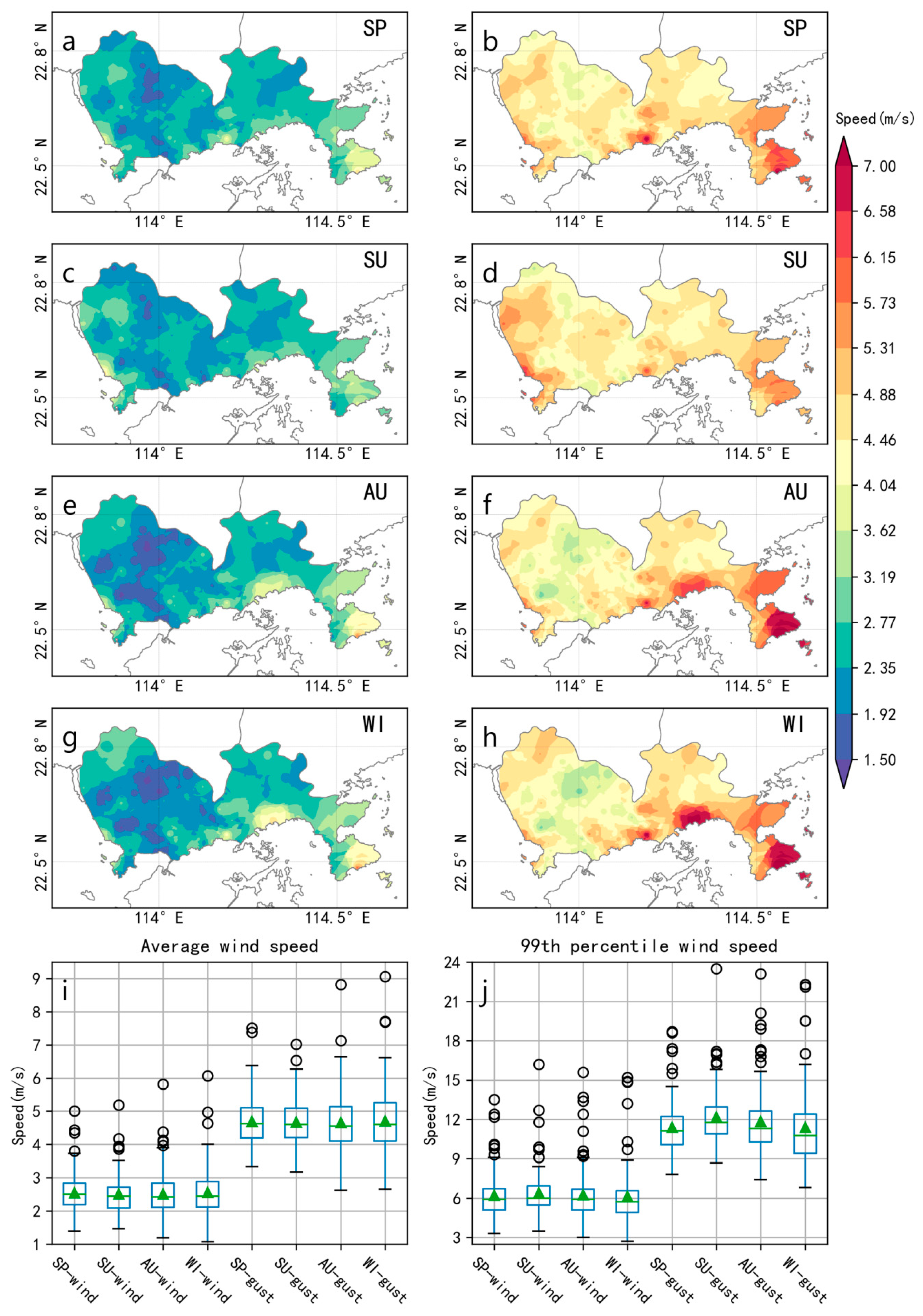
3.2.2. Seasonal Wind
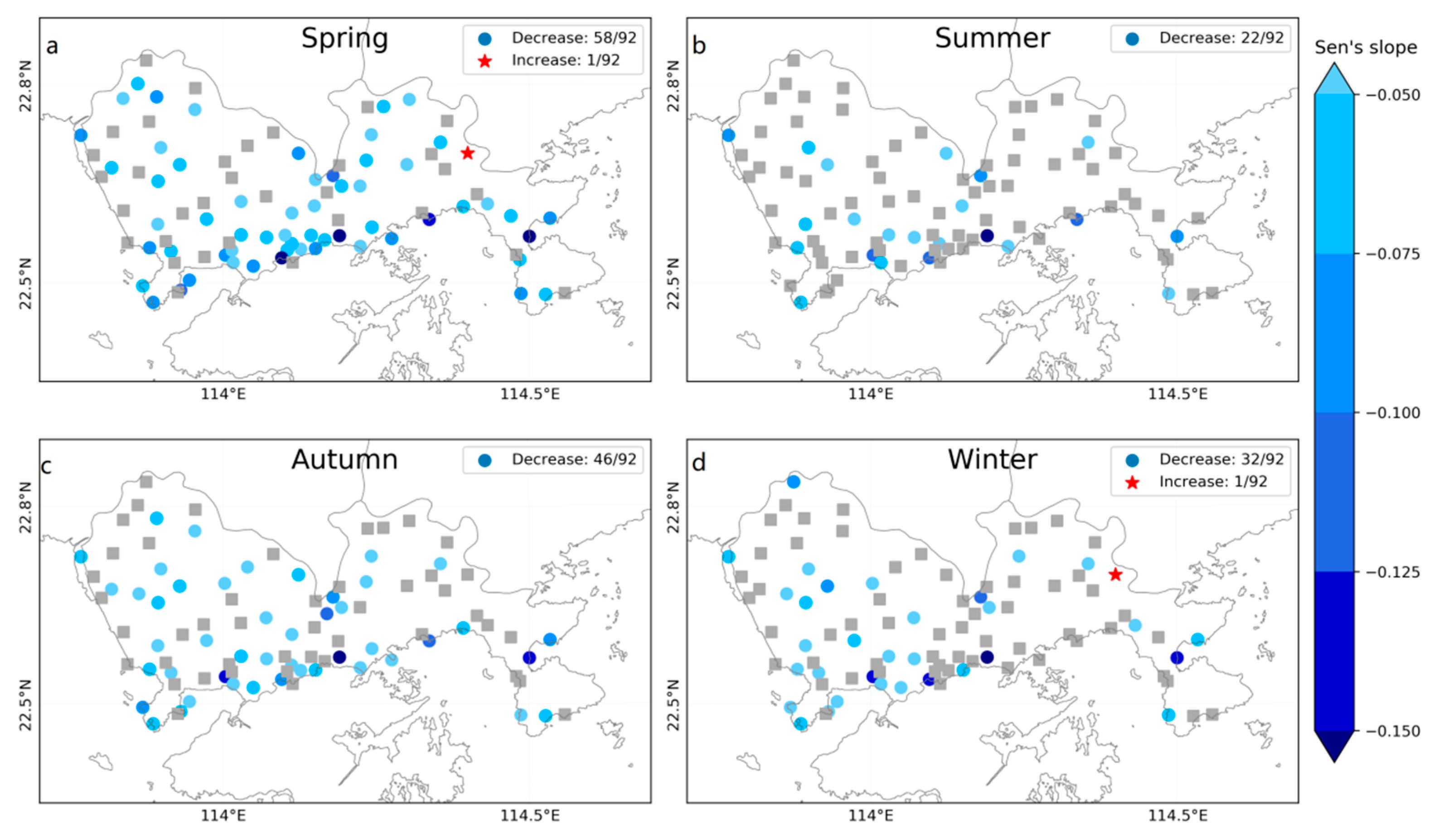
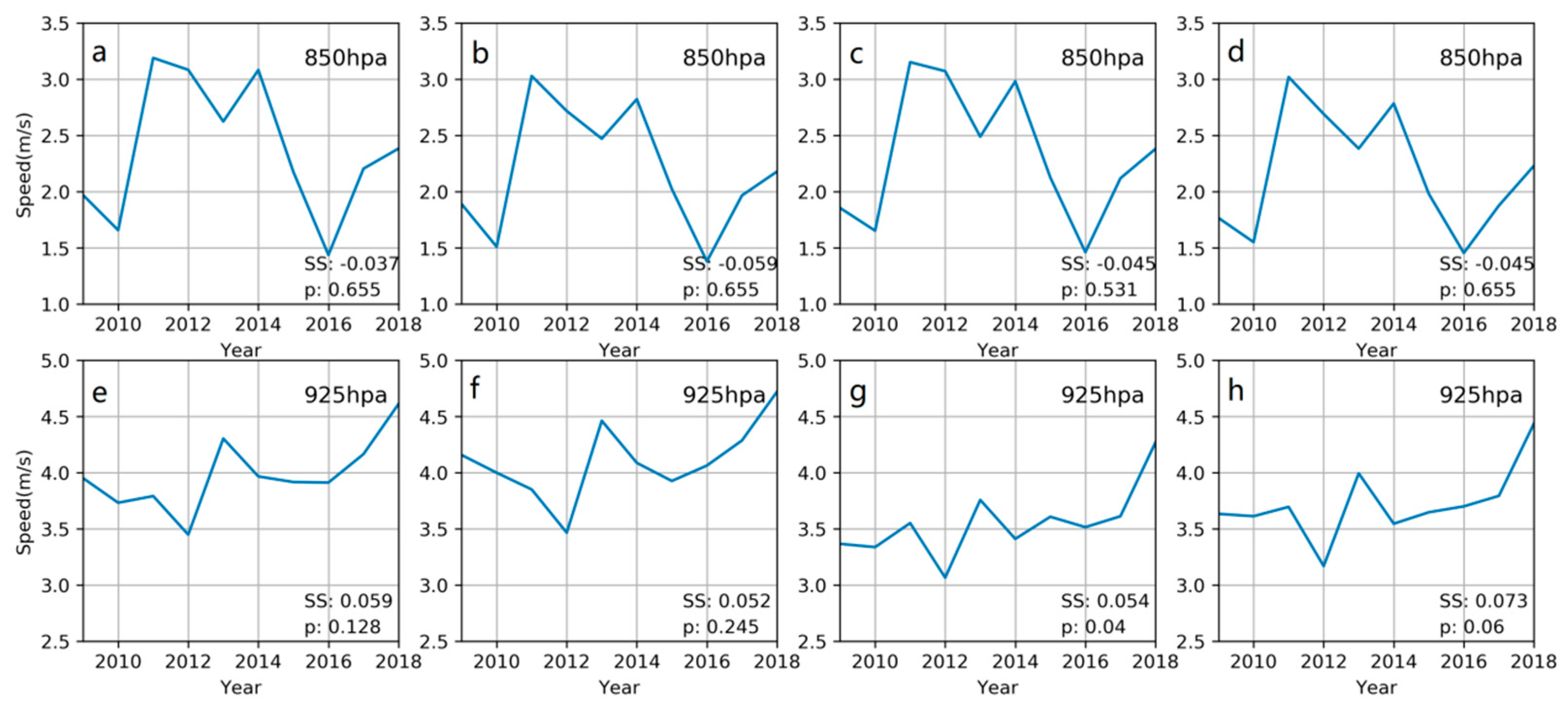
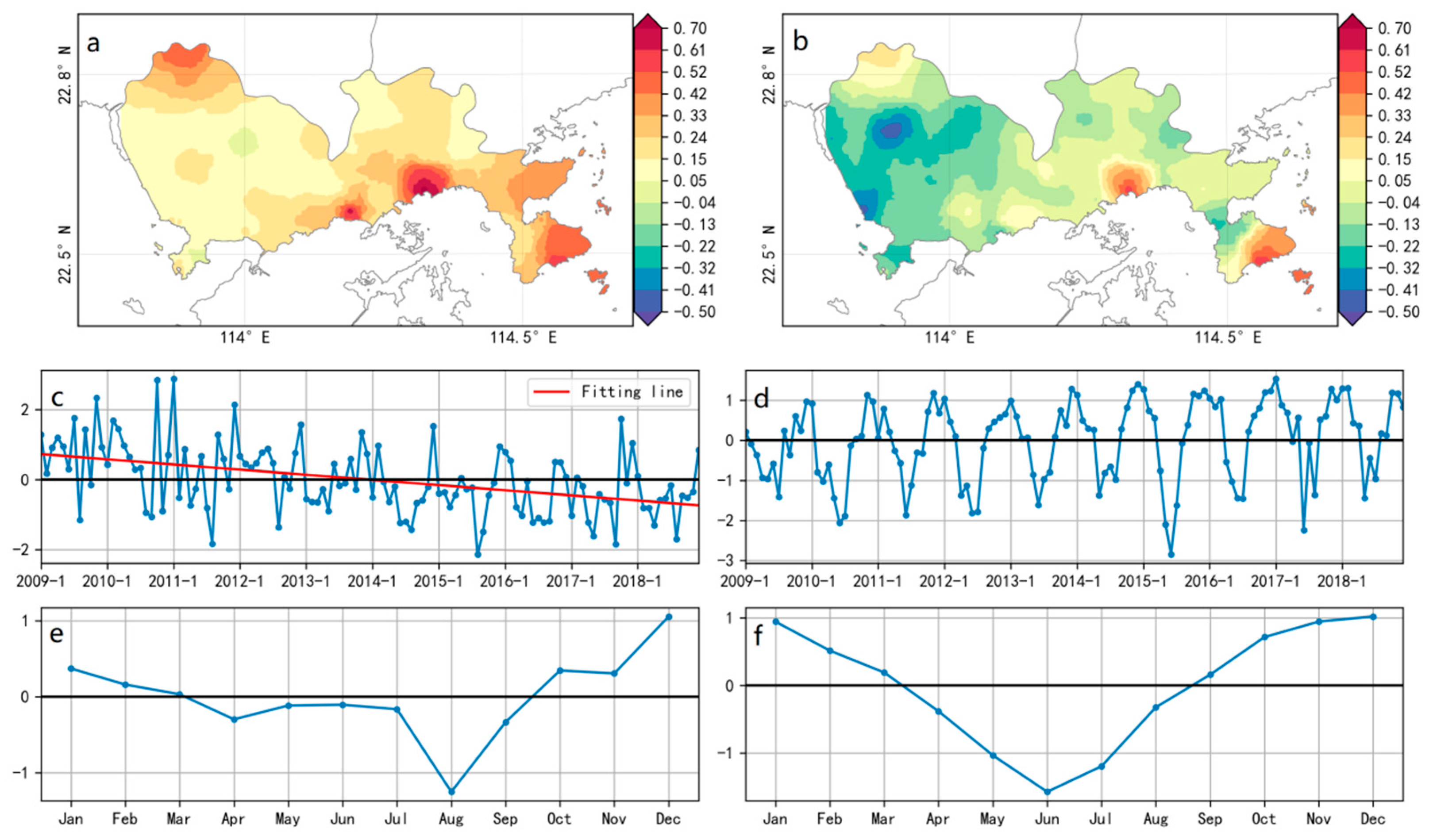
3.2.3. Trend Analysis
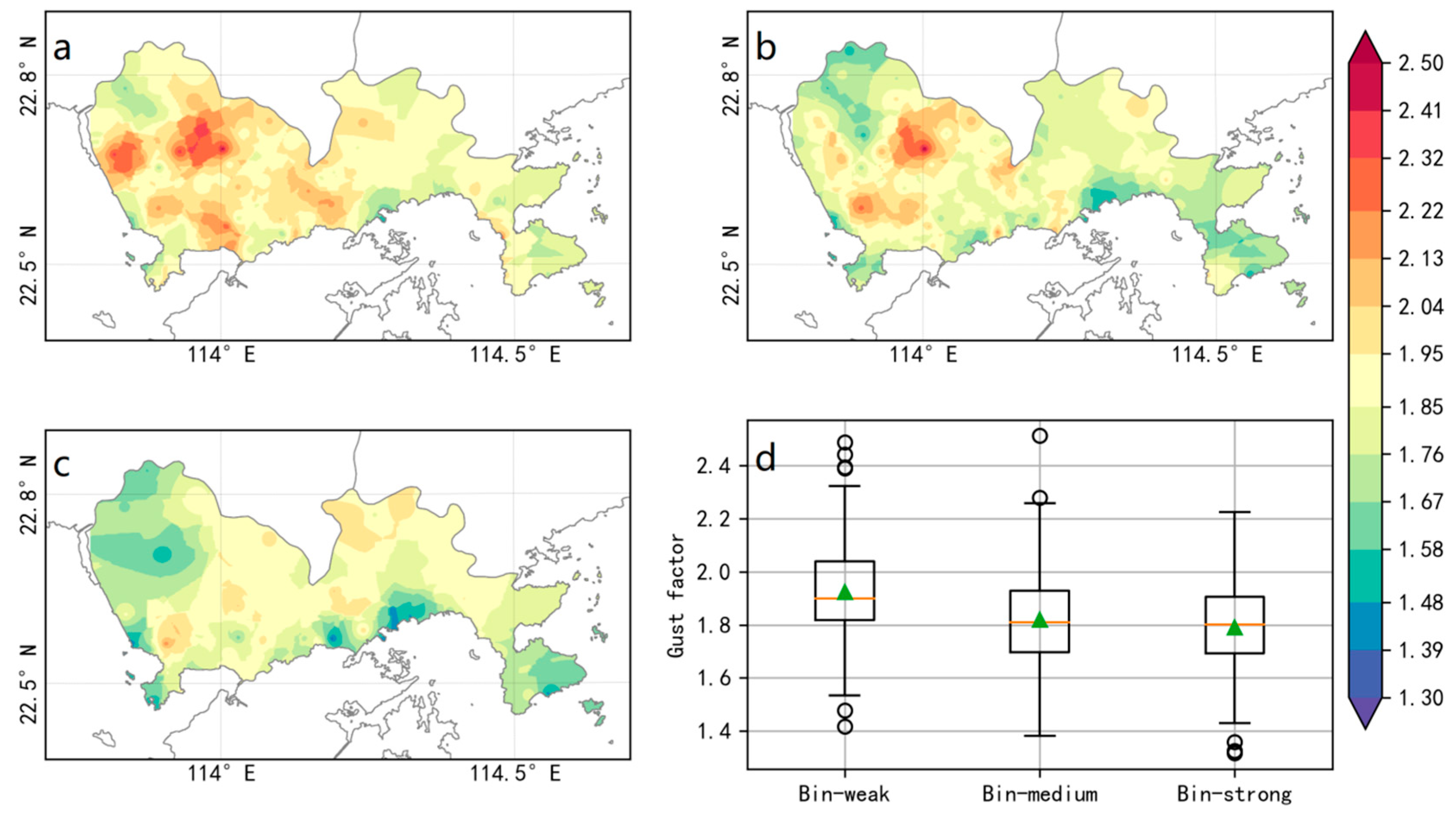
3.3. Gust Factor
3.4. Spatial Wind Characteristics
4. Conclusions
Author Contributions
Funding
Conflicts of Interest
References
- Paul, V.; Tonts, M. Containing Urban Sprawl: Trends in Land Use and Spatial Planning in the Metropolitan Region of Barcelona. J. Environ. Plan. Manag. 2005, 48, 7–35. [Google Scholar] [CrossRef]
- Boyle, R.; Mohamed, R. State Growth Management, Smart Growth and Urban Containment: A Review of the US and a Study of the Heartland. J. Environ. Plan. Manag. 2007, 50, 677–697. [Google Scholar] [CrossRef]
- Tian, L.; Li, Y.; Yan, Y.; Wang, B. Measuring Urban Sprawl and Exploring the Role Planning Plays: A Shanghai case study. Land Use Policy 2017, 67, 426–435. [Google Scholar] [CrossRef]
- Schell, L.M.; Ulijaszek, S.J. Urbanism, Health and Human Biology in Industrialized Countries; Cambridge University Press: London, UK, 1999; pp. 59–60. ISBN 978-0511525698. [Google Scholar]
- Yang, P.; Ren, G.; Liu, W. Spatial and temporal characteristics of Beijing urban heat island intensity. J. Appl. Meteorol. Climatol. 2013, 52, 1803–1816. [Google Scholar] [CrossRef]
- Zhang, C. Urban climate and air pollution in Shanghai. Energy Build. 1991, 16, 647–656. [Google Scholar] [CrossRef]
- Savard, J.-P.L.; Clergeau, P.; Mennechez, G. Biodiversity concepts and urban ecosystem. Landscape Urban Plan. 2000, 48, 131–142. [Google Scholar] [CrossRef]
- Zhang, L.; Li, Q.; Guo, Y.; Yang, Z.; Zhang, L. An investigation of wind direction and speed in a featured wind farm using joint probability distribution methods. Sustainability 2018, 10, 4338. [Google Scholar] [CrossRef]
- Wang, F.; Duan, K.; Zou, L. Urbanization Effects on Human-Perceived Temperature Changes in the North China Plain. Sustainability 2019, 11, 3413. [Google Scholar] [CrossRef]
- Jung, C.; Schindler, D. Modelling monthly near-surface maximum daily gust speed distributions in southwest Germany. Int. J. Climatol. 2016, 36, 4058–4070. [Google Scholar] [CrossRef]
- Klawa, M.; Ulbrich, U. A model for the estimation of storm losses and the identification of severe winter storms in Germany. Nat. Hazard Earth Syst. Sci. 2003, 3, 725–732. [Google Scholar] [CrossRef]
- Manasseh, R.; Middleton, H.M. The surface wind gust regime and aircraft operations at Sydney Airport. J. Wind Energy Ind. Aerodyn. 1999, 79, 269–288. [Google Scholar] [CrossRef]
- Schindler, D.; Grebhan, K.; Albrecht, A.; Schönborn, J.; Kohnle, U. GIS-based estimation of the winter storm damage probability in forests: A case study from Baden-wuerttemberg (southwest Germany). Int. J. Biometeorol. 2012, 56, 57–69. [Google Scholar] [CrossRef]
- Berkowicz, R.; Palmgren, F.; Hertel, O.; Vignati, E. Using measurements of air pollution in streets for evaluation of urban air quality—Meterological analysis and model calculations. Sci. Total Environ. 1996, 189–190, 259–265. [Google Scholar] [CrossRef]
- Wang, T.; Xue, L.; Brimblecombe, P.; Lam, Y.F.; Li, L.; Zhang, L. Ozone pollution in China: A review of concentrations, meteorological influences, chemical precursors, and effects. Sci. Total Environ. 2017, 575, 1582–1596. [Google Scholar] [CrossRef] [PubMed]
- Wu, J.; Zha, J.; Zhao, D. Estimating the impact of the changes in land use and cover on the surface wind speed over the East China Plain during the period 1980–2011. Clim. Dyn. 2016, 46, 847–863. [Google Scholar] [CrossRef]
- Guo, H.; Xu, M.; Hu, Q. Changes in near-surface wind speed in China: 1969–2005. Int. J. Climatol. 2011, 31, 349–358. [Google Scholar] [CrossRef]
- Ding, Y.; Li, C.; Liu, Y. Overview of the South China Sea monsoon experiment. Adv. Atmos. Sci. 2004, 21, 343–360. [Google Scholar] [CrossRef]
- Liu, F.; Sun, F.; Liu, W.; Wang, T.; Wang, H.; Wang, X.; Lim, W.H. On wind speed pattern and energy potential in China. Appl. Energy 2019, 236, 867–876. [Google Scholar] [CrossRef]
- Klink, K. Complementary use of scalar, directional, and vector statistics with an application to surface winds. Prof. Geogr. 1998, 50, 3–13. [Google Scholar] [CrossRef]
- Azorin-Molina, C.; Vicente-Serrano, S.M.; McVicar, T.R.; Jerez, S.; Sanchez-Lorenzo, A.; Lopez-Moreno, J.; Revuelto, J.; Trigo, R.M.; Lopez-Bustins, J.; Espirito-Santo, F. Homogenization and assessment of observed near-surface wind speed trends over Spain and Portugal, 1961–2011. J. Clim. 2014, 27, 3692–3712. [Google Scholar] [CrossRef]
- Jiang, Y.; Luo, Y.; Zhao, Z.; Tao, S. Changes in wind speed over China during 1956–2004. Theor. Appl. Climatol. 2014, 99, 421–430. [Google Scholar] [CrossRef]
- Mcvicar, T.R.; Roderick, M.L.; Donohue, R.J.; Li, L.T.; Niel, T.G.V.; Thomas, A.; Grieser, J.; Jhajharia, D.; Himri, Y.; Mahowald, N.M.; et al. Global review and synthesis of trends in observed terrestrial near-surface wind speeds: Implications for evaporation. J. Hydrol. 2012, 416–417, 182–205. [Google Scholar] [CrossRef]
- Hannachi, A. A Primer for EOF Analysis of Climate Data; Department of Meteorology, University of Reading: Reading, UK, 2004; 33p, Available online: http://www.o3d.org/eas-6490/lectures/EOFs/eofprimer.pdf (accessed on 21 October 2019).
- Lorenz, E.N. Empirical Orthogonal Functions and Statistical Weather Prediction; Scientific Report No. 1; Massachusetts Institute of Technology Department of Meteorology: Cambridge, MA, USA, 1956; Available online: http://bobweigel.net/csi763/images/pdf/Lorenz1956.pdf (accessed on 21 October 2019).
- Ludwig, F.L.; Horel, J.; Whiteman, C.D. Using EOF Analysis to Identify Important Surface Wind Patterns in Mountain Valleys. J. Appl. Meteorol. 2004, 43, 969–983. [Google Scholar] [CrossRef]
- Hughes, M.; Hall, A.; Fovell, R.G. Dynamical controls on the diurnal cycle of temperaturein complex topography. Clim. Dyn. 2007, 29, 277–292. [Google Scholar] [CrossRef]
- Beaver, S.; Palazoglu, A. Cluster Analysis of Hourly Wind Measurements to Reveal Synoptic Regimes Affecting Air Quality. J. Appl. Meteorol. Climatol. 2006, 45, 1710–1726. [Google Scholar] [CrossRef]
- Hannachi, A.; Jolliffe, I.T.; Stephenson, D.B. Empirical Orthogonal Functions and Related Techniques in Atmospheric Science: A review. Int. J. Climatol. 2007, 27, 1119–1152. [Google Scholar] [CrossRef]
- Huang, D. Analysis and forecast of cold wave in Guangdong. J. Guangdong Meteorol. 1995, 4, 2–6. (In Chinese) [Google Scholar]
- Lin, A.; Wu, S. The Characteristics of Cold Wave Action in Guangdong Province During Recent 44 Years. J. Trop. Meteorol. 1998, 14, 337–343. (In Chinese) [Google Scholar] [CrossRef]
- Tang, X.; Liu, H.; Pan, A.; Liang, B.; Li, Y.; Wang, T. Analysis of disastrous features of landing typhoon in coastal regions of Guangdong province in recent 50 years. Sci. Geogr. Sin. 2003, 23, 182–187. (In Chinese) [Google Scholar] [CrossRef]
- Zhang, T.; Fang, C.; Zhu, W.; Zhang, G.; Zhou, Q. Analysis of the 17 April 2011 severe convective weather in Guangdong. Meteorol. Mon. 2012, 38, 814–818. (In Chinese) [Google Scholar]
- Zhang, E.J.; Zhang, J.J.; Zhao, X.Y.; Zhang, X.L. Study on urban heat island effect in Shenzhen. J. Nat. Disaster 2008, 17, 19–24. (In Chinese) [Google Scholar] [CrossRef]
- Liu, X.Z.; Heilig, G.K.; Chen, J.; Heino, M. Interactions between Economic Growth and Environmental Quality in Shenzhen, China’s First Special Economic Zone. Ecol. Econ. 2007, 62, 559–570. [Google Scholar] [CrossRef]
- Wei, X.; Wang, D.; He, J.; Cheng, Z. Characteristics analysis on gust factors over coastal areas in Shenzhen. Guangdong Meteorol. 2016, 38, 33–36. (In Chinese) [Google Scholar] [CrossRef]
- Feng, S.; Hu, Q.; Qian, W. Quality control of daily meteorological data in China, 1951-2000: A new dataset. Int. J. Climatol. 2004, 24, 853–870. [Google Scholar] [CrossRef]
- Meek, D.W.; Hatfield, J.L. Data quality checking for single station meteorological databases. Agric. For. Meteorol. 1994, 69, 85–109. [Google Scholar] [CrossRef]
- European Centre for Medium-Range Weather Forecasts, 2012: ERA-Interim Project, Monthly Means. Research Data Archive at the National Center for Atmospheric Research, Computational and Information Systems Laboratory. Available online: https://rda.ucar.edu/datasets/ds627.1/ (accessed on 11 October 2019).
- Tyner, B.; Aiyyer, A.; Blaes, J.; Hawkins, D.R. An examination of wind decay, sustained wind speed forecasts, and gust factors for recent tropical cyclones in the Mid-Atlantic region of the United States. Weather Forecast. 2015, 30, 153–176. [Google Scholar] [CrossRef]
- Liu, B.; Li, Q.; Yang, L.; Li, H.; Cao, Y.; Tang, X.; Sun, S.; Sun, L. Seasonal wind characteristics in Shenzhen area. Meteorol. Mon. 2019, 45, 263–273. (In Chinese) [Google Scholar]
- China Meteorological Administration. The Criterion of Wind Scale in China. Available online: http://www.cma.gov.cn/2011xzt/20120816/2012081601/201208160101/201407/t20140717_252607.html (accessed on 21 October 2019). (In Chinese)
- Sen, P.K. Estimates of the regression coefficient based on Kendall’s tau. J. Am. Stat. Assoc. 1968, 63, 1379–1389. [Google Scholar] [CrossRef]
- Mann, H.B. Nonparametric tests against trend. Econometrica 1945, 13, 245–259. [Google Scholar] [CrossRef]
- Kendall, M.G. Rank Correlation Methods, 4th ed.; Charles Griffin: London, UK, 1970. [Google Scholar]
- Mardia, K.V.; Jupp, P.E. Directional Statistics, 1st ed.; John Wiley & Sons, Inc.: New York, NY, USA, 2000; pp. 15–17. ISBN 0-471-95333-4. [Google Scholar]
- Achberger, C.; Chen, D.; Alexandersson, H. The surface winds of Sweden during 1999–2000. Int. J. Climatol. 2006, 26, 159–178. [Google Scholar] [CrossRef]
- Xue, H.; Zhu, R.; Yang, Z. Study on land wind speed variation in coastal area. Acta Energ. Sol. Sin. 2002, 23, 207–210. (In Chinese) [Google Scholar]
- Yan, Y.Y. Surface wind characteristics and variability in Hong Kong. Weather 2007, 62, 312–316. [Google Scholar] [CrossRef]
- Chen, T.C.; Yen, M.C.; Huang, W.R.; Gallus, W.A. An East Asian Cold Surge: Case Study. Mon. Weather Rev. 2002, 130, 2271–2290. [Google Scholar] [CrossRef]
- Zeng, Q.; Zhang, D.; Zhang, M.; Zuo, R.; He, J. The abrupt seasonal transitions in the atmospheric general circulation and the onset of monsoons part I: Basic theoretical method and its application to the analysis of climatological mean observations. Climatic Environ. Res. 2005, 10, 285–302. (In Chinese) [Google Scholar]
- Martner, B.E.; Marwitz, J.D. Wind characteristics in southern Wyoming. J. Appl. Meteor. 1982, 21, 1815–1827. [Google Scholar] [CrossRef]
- Lau, N.C.; Lau, K.M. The Structure and Energetics of Midlatitude Disturbances Accompanying Cold-Air Outbreaks over East Asia. Mon. Weather Rev. 1984, 112, 1309–1327. [Google Scholar] [CrossRef]
- Jhun, J.G.; Lee, E.H. A new East Asian winter monsoon index and associated characteristics of the winter monsoon. J. Clim. 2004, 17, 711–726. [Google Scholar] [CrossRef]
- Xiao, F.; Xiao, Z. Characteristics of tropical cyclones in China and their impacts analysis. Nat. Hazards 2010, 54, 827–837. [Google Scholar] [CrossRef]
- Li, Q.; Xu, P.; Wang, X.; Lan, H.; Cao, C.; Li, G.; Zhang, L.; Sun, L. An operational statistical scheme for tropical cyclone induced wind gust forecasts. Weather Forecast. 2016, 31, 1817–1832. [Google Scholar] [CrossRef]
- Belu, R.; Koracin, D. Statistical and spectral analysis of wind characteristics relevant to wind energy assessment using tower measurements in complex terrain. J. Wind Energy 2013, 2013, 1–12. [Google Scholar] [CrossRef]
- Zheng, S.; Cao, C.; Cheng, J.; Wu, Y.; Xie, X.; Xu, M. A study on land use and land cover change during urbanization in Shenzhen using data from Chinese satellites. Sci. Sin. Inf. 2011, 41, 140–152. (In Chinese) [Google Scholar]
- Shenzhen Statistics Bureau, NBS Survey Office in Shenzhen. Shenzhen Statistical Yearbook—2018. Available online: http://www.sztj.gov.cn/xxgk/zfxxgkml/tjsj/tjnj/ (accessed on 22 October 2019). (In Chinese)
- Shen, L.; Zhao, C.; Ma, Z.; Li, Z.; Li, J.; Wang, K. Observed decrease of summer sea-land breeze in Shanghai from 1994 to 2014 and its association with urbanization. Atmos. Res. 2019, 22, 198–209. [Google Scholar] [CrossRef]
- Wieringa, J. Gust factors over open water and built-up country. Bound-lay Meteorol. 1973, 3, 424–441. [Google Scholar] [CrossRef]
- Harris, A.R.; Kahl, J.D.W. Gust factors: Meteorologically stratified climatology, data artifacts, and utility in forecasting peak gusts. J. Appl. Meteorol. Climatol. 2017, 56, 3151–3166. [Google Scholar] [CrossRef]


| SP-Wind | SU-Wind | AU-Wind | WI-Wind | SP-Gust | SU-Gust | AU-Gust | WI-Gust | |
|---|---|---|---|---|---|---|---|---|
| mean | 2.55 | 2.51 | 2.51 | 2.56 | 4.69 | 4.67 | 4.66 | 4.70 |
| median | 2.50 | 2.44 | 2.42 | 2.45 | 4.63 | 4.60 | 4.55 | 4.60 |
| SD | 0.64 | 0.63 | 0.74 | 0.80 | 0.77 | 0.72 | 0.95 | 1.03 |
| SP-Wind | SU-Wind | AU-Wind | WI-Wind | SP-Gust | SU-Gust | AU-Gust | WI-Gust | |
|---|---|---|---|---|---|---|---|---|
| mean | 6.25 | 6.43 | 6.28 | 6.15 | 11.40 | 12.18 | 11.85 | 11.38 |
| median | 5.91 | 6.0 | 5.90 | 5.72 | 11.11 | 11.75 | 11.30 | 10.75 |
| SD | 1.83 | 1.93 | 2.19 | 2.33 | 2.13 | 2.20 | 2.72 | 3.08 |
| Wind | Season | Mean SS (m s−1/Year) | Decreasing Number (Percent) | Increasing Number (Percent) |
|---|---|---|---|---|
| Avg-wind | annual | −0.04 | 85 (92%, 70%) | 7 (8%, 0%) |
| spring | −0.05 | 87 (95%, 63%) | 5 (5%, 1%) | |
| summer | −0.02 | 72 (78%, 24%) | 20 (22%, 0%) | |
| autumn | −0.04 | 82 (89%, 50%) | 10 (11%, 0%) | |
| winter | −0.03 | 78 (85%, 35%) | 14 (15%, 1%) | |
| Gust wind | annual | −0.06 | 85 (92%, 67%) | 7 (8%, 0%) |
| spring | −0.09 | 90 (98%, 64%) | 2 (2%, 0%) | |
| summer | −0.03 | 70 (76%, 14%) | 22 (24%, 0%) | |
| autumn | −0.07 | 84 (91%, 47%) | 8 (9%, 0%) | |
| winter | −0.04 | 76 (83%, 18%) | 16 (17%, 0%) |
© 2020 by the authors. Licensee MDPI, Basel, Switzerland. This article is an open access article distributed under the terms and conditions of the Creative Commons Attribution (CC BY) license (http://creativecommons.org/licenses/by/4.0/).
Share and Cite
Liu, C.; Li, Q.; Zhao, W.; Wang, Y.; Ali, R.; Huang, D.; Lu, X.; Zheng, H.; Wei, X. Spatiotemporal Characteristics of Near-Surface Wind in Shenzhen. Sustainability 2020, 12, 739. https://doi.org/10.3390/su12020739
Liu C, Li Q, Zhao W, Wang Y, Ali R, Huang D, Lu X, Zheng H, Wei X. Spatiotemporal Characteristics of Near-Surface Wind in Shenzhen. Sustainability. 2020; 12(2):739. https://doi.org/10.3390/su12020739
Chicago/Turabian StyleLiu, Cheng, Qinglan Li, Wei Zhao, Yuqing Wang, Riaz Ali, Dian Huang, Xiaoxiong Lu, Hui Zheng, and Xiaolin Wei. 2020. "Spatiotemporal Characteristics of Near-Surface Wind in Shenzhen" Sustainability 12, no. 2: 739. https://doi.org/10.3390/su12020739
APA StyleLiu, C., Li, Q., Zhao, W., Wang, Y., Ali, R., Huang, D., Lu, X., Zheng, H., & Wei, X. (2020). Spatiotemporal Characteristics of Near-Surface Wind in Shenzhen. Sustainability, 12(2), 739. https://doi.org/10.3390/su12020739