An IoT Smart Infrastructure for S. Domenico Church in Matera’s “Sassi’’: A Multiscale Perspective to Built Heritage Conservation

Construction Technologies Institute–National Research Council of Italy, 70124 Bari, Italy
*
Author to whom correspondence should be addressed.
Sustainability 2020, 12(16), 6553; https://doi.org/10.3390/su12166553
Submission received: 16 June 2020
/
Revised: 9 August 2020
/
Accepted: 11 August 2020
/
Published: 13 August 2020
(This article belongs to the Special Issue The Internet of Things in the Cultural Heritage Sector)
Abstract
:Architectural heritage is perhaps the most important marker of the Italian and European landscapes. Over the last decades, its strategic relevance for local economic development has led to prioritize tourism-oriented promotion objectives. Therefore, new light has been thrown on once unknown resources that have thus received the attention of tourists interested in new visit experiences. To this end, Information and Communication Technologies (ICTs) have delivered a crucial support mainly in terms of public attraction and creation of new cultural offers. However, new urgent challenges now face tangible heritage, whose physical existence is jeopardized through extreme events and poor maintenance. Unexpected intense visit flows represent in themselves a further threat for sensitive heritages. ICTs have then to cope with more complex conservation tasks and the Internet of Things (IoT) can facilitate appropriate solutions. The paper presents a smart sensor-based infrastructure for the structural monitoring of S. Domenico Church in Matera, an emblematic city for the concerns described, which also highlighted the need for a wider conservation concept also embracing context and fruition issues. The article introduces the case study and its delicate environment, and the technological background of heritage monitoring solutions; the proposed IoT infrastructure is then described, discussing its potentialities and IoT contribution to creating more holistic and multiscale perspectives to heritage conservation.
1. Introduction
Over the last decades, a large part of the research community in the field of tangible heritage has been focusing on the elaboration of possible solutions for its valorization, due to the strategic role that tourist promotion can play in the socioeconomic growth of territories. Indeed, as underlined in [1], cultural resources communication exerts pedagogical effects on communities, facilitates social cohesion, and sustains economy and employment, acting as strategic factor for the sustainable development of regions. The prioritization of promotion purposes in heritage projects has been favored by the increasing and more and more evident potential of ICTs for the communication and fruition—also in remote mode—of cultural and architectural resources. This extended to the huge wealth of less known assets, remained long out of the spotlight to the advantage of the so-called ‘main attractors’, thus engaging them in a renewed flow of initiatives and programs for communication and promotion, aimed to maximize territories’ development opportunities.
Recent extreme events occurring on the national and global scene (seismic activity, flooding, sudden collapses) [2,3] have brought about a further shift in perspective, re-directing the general attention towards the issues related to the physical conservation of resources.
An increasing awareness of the complexity of threats to heritage can be observed among major institutions of the field, at different levels. At the global level, the World Heritage Committee of the United Nations Educational, Scientific and Cultural Organization (UNESCO) [4] addressed the need for a systematic identification of the complex of heritage menaces by defining a standard list of primary and secondary factors of natural and man-induced risk (Table 1). At the European level, the EUROPEANA Foundation, tasked by the European Commission with developing a digital cultural heritage platform for Europe, while identifying and exploring the menaces affecting European heritage, is committed in ascertain the role that digital technologies can play [5]. In that scenario, major hazards are identified, as for natural risks, in extreme events, and, as for man-induced risks, in urbanization with subsequent old building demolition, political struggles and contestation of symbolic buildings, vandalism and terrorism, and above all in the risks associated to mass tourism and cultural resource over-exploitation [5,6]. EU funded projects have been investigating the sustainable management of cultural assets to increase their resilience in the CORDIS programme, while projects from both the 7th Framework Programme and Horizon 2020 deliver innovative strategies, solutions, techniques, and tools for the assessment, mitigation, management, and prevention of hazards [7].
In particularly sensitive contexts such extreme hazards overlap a pre-existing vulnerability, both intrinsic—i.e., due to heritage inherent characters—and induced by lacking or poor maintenance, which traditionally affects many regions and particularly less known assets. In this sense, the town of Matera in the south of Italy is, in its entirety, a delicate context.
The present article illustrates a smart infrastructure for the static monitoring of the S. Domenico Church with annexed monastery, now hosting the prefecture) in the historic center of Matera, whose damage pattern in response to vertical and seismic loads indicated clearly the need for extended reinforcement interventions in order to assure the compliance to safety requirements. Such concerns led to the assignment of the structural monitoring to an interdisciplinary public-private team. To this end, the first step was identified in the creation of an integrated system dedicated to support a structural engineers’ team, other than the article authors, in the assessment of the church’s structural health under vertical loads and seismic vulnerability, for the definition of possible solutions.
Although the task, assigned according to a ‘single-case’ managerial practice, pertained to the infrastructure for the sole church and monastery, the peculiarities of the context in which the complex is situated represented nevertheless the occasion for a thorough reflection on the need for a rethinking of immovable cultural resource conservation, on the most appropriate approach to it and on the possible contribution of the Internet of Things (IoT) from within a multiscale perspective.
The article presents the description of the designed IoT infrastructure, subsequently delivered to the structural engineers’ team for monitoring activities still ongoing, the results of which are beyond the scope of the present work. Issues related to the IT architecture of the infrastructure and the analyses it can support, as well as the design choices adopted will be, rather, deepened. The implications of the IoT will also be discussed in relation to a desirable broadening of action policies from the part of resource managers and to a rethinking of the approach to resource conservation, from the building scale towards a wider context scale, in the final part of the paper.
In order to support such discussion, it is worth introducing also the whole context of the church, highlighting the peculiar features that motivate the need for the proposed reflections and for a widening of the perspective in the field of heritage conservation.
The historic center of Matera and, in particular, its famous ‘Sassi’ district (‘rione Sassi’), inscribed in the UNESCO World Heritage List (WHL), has undergone for decades, alongside with the implications of its peculiar geomorphological features, also the injuries of time, abandonment, and absence of regular upkeep. Here, the sudden popularity of the city as the 2019 European Capital of Culture has triggered complex, profound, and fast-paced transformations.
The ‘rione Sassi’ (Figure 1) consists of a complex of dwellings, religious hypogea, monasteries, and hermitages realized in natural caves or carved in the rock, inhabited since the Paleolithic age and uninterruptedly over the subsequent millennia. Its morphology is marked by deep grooves or canyons (‘gravine’), cracks, highlands, rock spikes, and caves whose occupation intensified from the 8th century on, expanding beyond he first inhabited nucleus (the ‘Civita’) and giving shape to one of the most suggestive landscapes in the Mediterranean region. At both flanks of the Civita, built on the top and along the flanks of a rock spike, two hollows run, called ‘Sassi’—namely, ‘Sasso Barisano’ and ‘Sasso Caveoso’, corresponding to the present main roads of the zone—where originally two waterways (‘grabiglioni’) coursed, which represented an ancient outflow system for urban and natural water.
In the 1950s, with the coming of new living standards and the strong impetus of building activities originating from the so-called “economic boom”, the government ordered the evacuation of rock-carved dwellings and the displacement of inhabitants in new-built residential neighborhoods. The ‘Sassi’ emptied out gradually, remaining as a contested symbol of no more acceptable living conditions and left to disuse for two decades, until the spring of a new-born interest towards their revitalization. Only in 1993 the ‘Sassi’—alongside with the Park of Rupestrian Churches, comprising more than one hundred religious buildings carved in the rocks—were inscribed in the UNESCO WHL, being the first accredited site in southern Italy. Among the multiple motivations for the inscription, specific importance was acknowledged to the peculiar water collection system conceived and adopted by ancient inhabitants, consisting of rock reservoirs, caves, and dug ice-houses (Figure 2 and Figure 3).
The Church of St. Domenico is located in a more recent area within the ‘Sassi’. Originally at the edge of the ancient inhabited nucleus, it is part of a monumental complex, comprising also the monastery, built in 1230 in Apulian Romanesque architectural style, and has undergone diverse structural and stylistic modifications over the centuries, however maintaining in the façade its original appearance. Its vaulted structure enshrines several antiques dating back to the XVIth-XVIIIth centuries: wall stuccos, the coffered dome, the sepulchre of the jurist Orazio Persio and the Persio Family Chapel (XVIIth century), paintings from the XVIIth and XVIIIth centuries, the stone statues of the Virgin Mary and St. Peter from the XVIth century, and a pipe organ from the XVIIIth century.
The whole structure of the church and monastery is a complex “suspended” over the “underground Matera”. Indeed, although the “Sassi” are world-renowned for their dwellings, perfectly visible in the valley, the calcareous rock has shaped those places in a much deeper, hidden, and unsuspected way, giving life to a whole ‘additional’ reality that is still unknown, to a large extent, even to residents. The “Palombaro Lungo”, one of the visit destinations of Matera, not fully explored yet, is at present the largest cistern in the world for rainwater collection, with a capacity of 5 million liters, 1-m deep and 50-m long, as a result of several excavations carried out in time starting from the XVIth century. It is integral part of the ingenious water collection system represented by the Sassi, which branches out in a wider network of underground caves, spaces, and tunnels, partly restored and partly still unexplored, with access located exactly in the area underlying the Church of St. Domenico, whose actual extension is unguessed by the resident population living and walking on its surface (Figure 4). The “Palombaro Lungo” cistern can be navigated, e.g., with inflatable rafts, for maintenance reasons, but is currently closed (Figure 5).
Getting back to the church, this is affected by structural problems—ultimately an insufficient absorption of thrusts exerted by arches and vaults—to which significant leaking and moisture phenomena must be added, related to the ancient morphological setting of its foundation and to the centuries-old presence of the two drains and of the reservoir.
For the purposes of physical conservation, the articulated scenario described above required a “double scale” solution, taking into account not only the structural complex (church and monastery) as object of the assignment but also its peculiar surrounding. In order to minimize the physical impact of interventions, the possibility to take advantage from the potential of sensor-based monitoring revealed crucial.
In the following paragraphs, we present a state-of-art overview of sensor- and IoT-based developments for the structural monitoring of buildings and the architecture conceived for the case study. Implications and possible developments are discussed in the final part of the article.
2. Background
It is known that in the near future, the number of new IoT applications and the management of the data generated will grow considerably together with the requests of increasingly demanding customers, it is even estimated that more than 90% of cars will be connected to the internet [12]. With these premises, it is clear that the needs of a faster network will grow together with another type of requirement, that of creating more intelligent and reliable applications, with an increasingly scalable architecture. But a network that is capable of supporting an ever-increasing number of IoT devices and which is reliable and responsive is a great challenge today. The choice of technologies, therefore, at the basis of architectural design, must meet increasingly difficult requirements to be met, determined on the basis of right compromises.
From research by Intel and IBM [13] emerges that today IoT architectures are particularized in various subdomains and the use cases are distributed in various sectors, thus determining and pointing to different and specific architectures, also based on different requirements (scalability, flexibility, robustness, etc.), which cannot always be satisfied simultaneously in an IoT solution. These solutions today offer, at affordable prices and with great flexibility, a wide range of applications in the cultural heritage sector: from monitoring the environmental parameters of a room in a museum to detecting structural changes in a historic building and protecting vulnerable artifacts [14].
A typical IoT solution involves many heterogeneous IoT devices, the combination of information technologies and advanced communication systems, together with sensors that produce data in different formats, at different speeds, processed and analyzed to obtain insights, very often generates a variety of new and potential applications. It is precisely the heterogeneous composition of the network of things—”things”—that is today the basis of the success of the Internet of Things (IoT), also called the world network of interconnected objects internally addressable [15].
Since a standard IoT solution generally consists of a “wireless sensor network” (WSN) type, today we tend to use terms like IoT and WSN as synonyms [16], however we will clarify, in the following paragraph and in the case study what the diversity of these networks consists of, both in terms of architecture [17] but above all in terms of services that the different networks can provide and their applicability in the conservation of the historical-architectural heritage.
In all this complexity, designing an IoT architecture can prove to be a very demanding activity, which experts in the field (Intel, IBM, etc.) believe may be less expensive if you follow a layered and reference architecture, based on sufficient interoperability and safety criteria [18].
2.1. WSN and Conservation of the Historical-Architectural Heritage
A WSN is a successful paradigm widely used in the past fifteen years, employed in a wide range of applications, ranging from environmental monitoring to the management of energy efficient buildings. Today it consists of intelligent devices that can communicate, in a spatially limited area, through radio waves (can communicate through direct radio communication) [19].
Recent advances in the field of nano-technology, wireless communications, and low-power integrated circuits have led to a much lower marketing cost of devices that are increasingly smaller and less aesthetically invasive, but much more efficient from the digital technology point of view of, able to use increasingly advanced standards and protocols, with an increasingly reduced consumption of energy. The combination of these steps has led to the birth and implementation of a multitude of intelligent sensor nodes, thus allowing the acquisition, processing, analysis, and dissemination of useful information, collected through the wireless network [20].
In this type of simple infrastructure, the sensors are nodes of a network and can be connected either directly to a network or through a gateway device, which allows the devices to communicate with each other and with higher level services and applications.
For this type of solution, the widely used architectural structure is a simple three-layer (3-layer) architecture (see Figure 6), considered easy to implement, where the WSN is the detection technology implemented and related to the level of “perception layer”, however for this architectural layer, the WSN is not the only detection technology largely used today, but there are many others, such as: RFID (Radio-Frequency Identification), bar code, wearable device, etc. (see Figure 6).
The “perception layer” is simply made up of integrated hardware for the perception and acquisition of data and the information and communication technology, at this level, can only generate intelligent sensor applications, able of simplifying the connectivity between objects, in addition to facilitate the exchange of information between them.
The application of this detection technology in the scientific field is today fundamentally oriented to prepare the number and type of sensors of a WSN, able to provide designers and structural engineers with any type of information useful to understand the evolution of the structural response of the building, in order to assess the extent of the phenomena of damage suffered or potential and possibly arrange for maintenance or structural reinforcement. For these purposes always, a permanent monitoring network is also active in Italy, managed by the Seismic Observatory of Structures (OSS), as surveying the work under analysis as one of the cornerstones that make it up.
The nominal life of a cultural asset should be very long, guaranteeing its conservation over time also with regard to seismic actions characterized by a high return period; however, this challenge would lead to a very severe seismic verification. Today, the trend is to take advantage from cognitive and technological progress, in terms of knowledge of seismic hazard, but above all, in terms of ability to assess the vulnerability of construction and the availability of less invasive intervention techniques.
Even the mere realization of a project for the improvement of protected cultural heritage, as in our case study, necessarily implies:
- The achievement of an adequate knowledge of the structure, an essential prerequisite to identify the characteristics of the elements that determine the structural behavior;
- The adoption of one or more mechanical models of the structure or of its parts (macro-elements, case study), able to describe the response under dynamic action, and consistently choose one or more methods of analysis, so as to be able to perform assessments with an appropriate level of accuracy suitable for the purposes of the study.
The level of knowledge acquired, in terms of importance of the cracking framework, the identification of the transformation phases, etc., becomes a fundamental element both for the choice of the mechanical model and for the evaluation of its reliability. However, acquiring a level of knowledge of an architectural complex is always a very complex path that is traced, even today, in the awareness that the modeling and verification prescriptions indicated for ordinary buildings cannot always be applied to protected cultural assets, forcing designers and structural engineers to calculate the levels of seismic actions for the structural type of the building, in the previous and in the following situation of any intervention.
Knowledge is therefore a fundamental prerequisite to be pursued, but that must combine together a lot of information along its path: from the acquisition of the original characteristics of the work, to the changes that have occurred over time due to damage, anthropic transformations, aging of the materials, and calamitous events. Furthermore, in order to reach an exhaustive knowledge of the architectural complex, there is the need to preserve the building, preventing irreparable losses through invasive destructive tests and investigations.
The goal is always to reach an in-depth level appropriate to the legislation, which however is strictly linked to the accuracy of the relevant operations, historical research, and experimental investigations carried out.
It is in this context, therefore, that we focus on the application and use of a WSN aimed at increasingly diversified investigations in the experiments and more and more accurate and reliable. Furthermore, it is recommended to compare the results of several investigations based on different physical principles for the same product. As prescribed by Standard 42/93, the methodologies adopted to carry out the investigations must be characterized by technique, instrumentation, and measurement parameters, in order to allow the repeatability and comparison over time of the results obtained. However, some researchers believe that such an implementation is not yet able to provide a reliable solution [22].
Although intelligent nodes, because they allow the correlation of certain measured quantities and the processing of more advanced information, they are simple nodes and not “things” in IoT jargon.
It is only at the end of this path towards an adequate knowledge of the structure that we proceed to the adoption of one or more mechanical models of the structure or its parts (macro-elements) and therefore to lay the foundations for a system of structural monitoring.
The monitoring strategy that can be adopted requires a distinction between two modes [23]: static [24] and dynamic [25,26].
Dynamic monitoring is oriented to the control of dynamic properties of the structure being measured, both in operating conditions and during extraordinary events. Specifically, dynamic monitoring has the aim of providing a dynamic characterization of the structure, by instruments capable of performing dynamic tests, measuring the characteristic vibrations of the structure induced by forced variations or natural phenomena. Data collection takes place through the use of a series of seismometers installed at various altitudes and in significant points of the structure.
Forced variations can be produced by local hammering systems or by vibrodines (eccentric mass rotating machines that induce forced vibrations in the structure), while environmental excitations are caused by natural phenomena such as wind, an earthquake, or by anthropogenic phenomena such as traffic, etc. The survey of the data is carried out through a series of accelerometers placed in the most significant points of the structure. By repeating the excitation at regular intervals, according to the parallel and orthogonal directions to the lying plane of the investigated structure, the modal parameters (frequencies and damping) are determined. Then, the response of the structure is calculated in terms of displacements, speeds, and accelerations.
Static monitoring is aimed at the continuous and regular detection of some parameters and for rather long periods of time. Typically, it translates into the study of the deformations evolution of the structure over time and is suitable for structures that have very important cracking and yielding patterns, such as our case study. The knowledge of the crack pattern evolution requires a minimum observation period of at least 18 months. The points to be monitored and on which to carry out direct and indirect measurements are points falling in areas of particular vulnerability, representative of the overall behavior of the structure and in secondary areas, but that can interact with adjacent structures. It is customary to use sensors such as electrical strain gauges for this type of monitoring and inclinometers are used for angular displacements.
The challenge today, with the help of IoT technology, is to create a structural monitoring system (both static and dynamic), which is made up of sensors able to measure both the environmental quantities and the structural response to environmental stress, evaluating, for example, the influence of temperatures on the dynamic behavior of the structure [27], or creating permanent systems capable of self-activating and recording the motion of the structure whenever a micro-earthquake or significant vibration occurs that exceeds a certain value of threshold. Another common need is that of having a large availability of data memory for the collection of the acquisition system.
However, this presupposes the involvement of a large number of applications in the civil engineering field: design, damage assessment, maintenance and reinforcement of existing structures, structural control during earthquakes [28] with the creation of more advanced infrastructures than the WSN. In fact, today, a structural monitoring system based only on the WSN paradigm does not meet the fundamental quality of service (QoS) requirements such as reliability, error tolerance, synchronization, real-time response, and energy efficiency consumption (such as reliability, fault tolerance, synchronization, real-time response, and efficiency in energy consumption) [29,30].
Recent advances in electronics, wireless communication, and software have opened the door to a new generation of devices, densely connected and capable of sharing information with the whole world, known as the Internet of Things (IoT), where WSN networks play an important role. It is the combined use of IoT and WSN that, together with specific sensors and on a larger scale, provides an ad-hoc, economic, and easy way of creating a monitoring system, where data can be shared between different entities [30], these systems are called structural health monitoring (SHM).
2.2. Structural Health Monitoring (SHM)
SHM is the process of observing structures through the periodic collection of measures, that allow the extraction of sensitive characteristics to damage and, through their static analysis, it is possible to establish the structure state of health. The results of the analysis, if periodically updated, provide useful information about the capacity of the structure to ensure the continuity of its use. In particular, in the presence of extreme phenomena, such as earthquakes or explosions, monitoring allows to establish the performance of the system during these events and to provide useful data about the integrity of the structure [31].
Monitoring the health of civil structures in general is essential to keep track of aging and observe any structural changes, to prevent any collapses, particularly in structures subject to stress such as bridges and viaducts.
If we think about the evolution of the city of Sassi, this monitoring is essential. Structurally critical elements are the “grabiglioni”, natural ditches which, before the rehabilitation period, were covered by roofing platforms to allow higher road traffic. In fact, currently, the main road of the “Sassi” flows above the “covered grabiglioni”. Even today, there are no conditions that allow continuous monitoring of the platforms built, with the risk of collapses without any warning of deformation due to the wall structure of the supports of these platforms. The increase in urban traffic, even with vehicles of considerable weight, makes necessary to adopt continuous monitoring in order to acquire signals of deformation in advance and avoid problems for public safety.
In general, the process is very complex and aims at assessing any type of variation that may influence the structural performance of an infrastructure and is attributable to changes in materials, geometric properties, boundary conditions, and constraint configurations. In summary, the assessment of the damage [32], where the damage is intended as any change that, introduced into the system, may negatively affect its current and future performance.
Today there are SHM systems managed in the cloud that, by combining the various latest generation digital technologies, allow public administrators or companies, managing public services under concession, to implement a systematic and continuous monitoring of infrastructures.
However, creating dynamic or static monitoring, intelligent and increasingly integrated (even with weather services, for example), able to foresee the causes of possible breakdowns and breakages is today a difficult task because it requires the involvement of very broad resources and skills.
Think about the creation of real computerized land registers based on blockchain technology [21] of civil works, where the integration and combination of information, such as: age of the work, history of maintenance interventions, health status or the flow of data relating to structural parameters provided by IoT technologies, together with other federated services such as the detection of presences and the increase in traffic/flow rate, the stress related to structural degradation and deterioration of materials, will allow the classification of infrastructures in relation to the potential risks and define priorities for intervention.
It is for these reasons that in SHM we talk about critical infrastructures (CI), the identification of which has become a priority for all the countries of the world with the aim of reducing their vulnerabilities and improving their protection from terrorist attacks or natural disasters, among other threats.
SHM is therefore a complex process of gathering basic information, capable of detecting, locating, and quantifying vulnerabilities (fatigue cracking, degradation of boundary conditions, etc.) in order to improve CI resilience.
Implementing a SHM process is demanding and in a context such as the “Sassi di Matera”, it is a real challenge, the aim of our research path. The WSN paradigm and a 3-layer architecture are no longer sufficient [22] for the implementation of a SHM, and for these solutions, the use of cutting-edge middleware for the WSN focused on specific requirements for the SHM is unavoidable.
At the architectural level, the “middleware layer” is interposed between the network and the application layer, with the aim of hiding hardware details and allowing developers to concentrate on the application of expansion process. It is that part of the technological and architectural infrastructure responsible for the provision of services to customers and their delivery in an efficient and safe way, a layer interposed to guarantee the interoperability, scalability, and abstraction of the IoT solution. Generally, the less advanced SHM has a 4-layer infrastructure: “perception layer”, “network layer”, “middleware layer”, and “application layer”, where the “network layer”, similarly to the “3-layer” architecture, provides the basic support services for the secure transfer of data through sensor networks (WSN). It is also responsible for aggregating information from various sources and for their routing to the correct destinations and has the task of transferring information through the use of wireless network technologies such as 3G, Wifi, Bluetooth, infrared, etc. “Application layer” is the highest level of an IoT architecture and focuses on the provision of services made available to the end user and the application of the IoT solution.
However, the architecture mostly used for SHM is the five-layer IoT, as shown in Figure 7, introducing two additional levels compared to the previous structure. The “transport layer”, transferring the information detected by the sensors to the processing layers (“processing layer”), is typical of networks focused on wider applications and linked to the transport layer (ISO-OSI model) such as wireless, 3G, LAN (Local Area Network), Bluetooth, RFID, and NFC (Near Field Communication).
Although we find that network technologies and architectural choices are very similar, we agree with the analysis by Alonso et al., 2018 [30] according to whom it is not possible to build a generic SHM to supervise (supervise) multiple ICs, but it is necessary to carefully analyze each IC in order to design the most appropriate system. On the other hand, it is also true that after building a SHM and therefore positioning a series of sensors and actuators, it is a well-established practice, also in the European scenario, to use this information also for other IoT applications, avoiding the construction of unnecessary vertical “silos” applications [33]. This necessarily implies the structuring of an entire IoT ecosystem, which is based on highly interoperable IoT solutions, so that they can provide the data collected to other applications, in the form of services and with the adoption of specific frameworks.
2.3. Ecosistemi IoT
At a higher level, in fact, the IoT is one of the key paradigms that support smart cities [34,35,36]; it enables systemic instrumentation of entire cities for intelligent applications including monitoring of buildings, traffic, and environmental parameters. However, when the scale of the IoT system increases [37], the architectures are more complex and data mining techniques are needed to exploit and process the collected data and big data methods [38] for their management.
IoT ecosystems generate huge volumes of data requiring connectivity and network capacity, processing, and storage resources to transform these data into useful information or services. In addition to reliable connectivity and network scalability, computer security and data privacy are of paramount importance in the use of IoT networks. The reliability of IoT data can be achieved by using distributed signal processing methods that perform a verification process among all its physical objects to ensure that the data remains immutable and not tampered with. The combined intelligence of IoT and blockchain technologies [39] provides a verifiable, secure, and robust mechanism for storing and managing generated or processed data by connected smart devices.
The commitment in the field of research today is concentrated on the design of semantically interoperable systems, in order to create increasingly integrated applications, services and data flows, a federation of IoT ecosystems, architectures, and middleware infrastructures, capable of reusing existing sensors, increasing the ROI (return-on-investment) associated with the construction of expensive infrastructures for the construction of the smart city [40].
Consequently, the ability to combine and synthesize data flows, services, and applications from different IoT platforms is a further challenge for the world of research, with the aim of expanding the scope of applications by creating higher level services, where the services of specific systems are integrated into a design approach of federated services and the centrality of data is the real added value of this approach.
Today, the evolution is to structure six-level and seven-level architectures that allow the development of IoT ecosystems focused on multiple thematic areas (“focus layer”) or also capable of extending the ability to observe and detect, as the one to observe “physical moving objects, such as humans, cars, environmental factors such as, temperature or humidity”, as well as capable of creating service-oriented technologies such as GIS mapping, cloud computing, big data, cognitive computing, etc.
The trend is to build IoT applications within a real and powerful framework for the development of IoT platforms, generated on criteria of flexibility, that is able to distribute “things” in different contexts, on usability criteria that are able to simplify the end user experience and productivity, that is able to favor the design of increasingly efficient services in terms of hardware connectivity and data processing outside the data center (edge computing/fog computing), towards an IoT infrastructure no longer traditional, but capable of giving information and making decisions “on the fly”, simplifying the management of the flow of data and devices and increasingly expanding the functionality for final users.
Standards for low power networks, such as LoRaWAN (Long Range Wide Area Network) or NB-IoT (NarrowBand Internet of Things), have created new opportunities, allowing even very small devices to connect to an IoT network. New standards have been developed specifically for IoT use cases, such as MQTT (Message Queuing Telemetry Transport) for messaging, OMA Lightweight M2M for device management or W3C Web of Things, and oneM2M for interoperability of services. Moreover, significant improvements have been achieved today in data storage, data analysis, and event processing that allow an IoT infrastructure to support also a quantity of data, generating entire large-scale IoT distributions.
In this scenario, the advantages of using specific frameworks for the development of an IoT architecture are manifold today and can guarantee greater performance in terms of security, interoperability, scalability and manageability, and advanced data analysis, from the sensor to the data center. The even more significant advantage in the use of frameworks is that of using IoT software platforms that are already able to integrate sensors/actuators, also very heterogeneous and that use different communication protocols, as they are capable of abstracting all diversity and complexity, through simple APIs (Application Programming Interfaces) that allow any sensor to communicate with any network.
More and more cloud-based IoT solutions or platform as a service (PaaS) solutions are emerging today, providing developers with assistance in entering, storing, and analyzing data, so that they can focus on creating applications and services. PaaS solutions provide services by abstracting the underlying network (acquisition, calculation, and storage infrastructure) and allowing developers to focus solely on mobile and big data functions; developed on increasingly sophisticated and widespread devices (sensors/actuators) and the development of features for data entry/processing and analysis in terms of services.
An example of the IoT ecosystem designed to create a monitoring system based on IoT is that proposed by Gribaudo et al. [14], in which the authors propose a technique to shape the performance of a monitoring system aimed at planning and managing accidents in a protected site, using multiple heterogeneous sensors scattered throughout a vast area of the city of Matera, to monitor the behavior of the crowd in case of particular events.
From a study, published by the PAC company (https://www.pac-radar.com/) in September 2018, it appears that: “There is a group of existing horizontal IoT platforms that have high potential to position themselves as IoT developer platforms. They include big players such as Microsoft, AWS, SAP and IBM; and there is also a new group of open-source platforms with more and more IoT capabilities, such as Eclipse IoT or FIWARE”. PAC screened more than 120 platforms, evaluated 43 of them in seven different segments, and through this approach identified a ranking of the best providers in different areas. The seven segments are: IoT platforms for rapid application deployment, IoT platforms for device management, IoT platforms for analytics applications, IoT platforms for device development, vertical IoT platforms are newly emerging, industrial IoT platform, IoT platforms for connected vehicles, IoT platforms for smart cities. Across all seven segments, only 12 players achieved a good ranking: AWS, Bosch Software Innovations, FIWARE, GE Digital, Harman, IBM, Itron, Microsoft, PTC, SAP, Siemens, and Software AG [41].
The world of IoT projects is largely composed of programs released under open source license and systems that exploit the potential of open data (FIWARE Context Broker and the FIWARE NGSI API).
Today, in the European context, FIWARE [42,43,44] is a pillar in the IoT field and it was one of the first initiatives successfully concluded and supported by industries in the sector that started working on projects aimed at developing a new generation IoT platforms. The goal was to create a situation of understanding between the sector participants, so some foundations have decided to introduce a series of architectural standards and some reference architectures [45].
It is in 2009 that the European Commission launched the Future Internet program as a public-private partnership together with European industries and as a first attempt to coordinate efforts to achieve this goal is the FIWARE program (acronym for Future Internet WARE) in 2011, bringing together various architectural projects and developments. In 2012, a protocol was published, the NGSI protocol (Next Generation Service Interfaces Architecture) by the OMA for the management of the application context of systems in general and again in 2013 with the definition of the service level suitable for M2M communications by the ETSI (European Telecommunications Standard Institute) with the OPC UA (Open Platform Communications Unified Architecture) protocol.
Additionally, in 2012, FIWARE was born, a technological solution consisting of so-called generic services (Generic Enabler) [46], which in 2014, in a new guise, makes available to anyone who wants to try the services of the solution through the FIWARE Lab, a cloud environment distributed throughout Europe, transforming itself into a truly open, public, and royalty-free platform where you can share and promote open source and innovative projects. In 2015, a thousand applications use FIWARE and by February 2017 more than one hundred cities in Europe had already joined the project.
Dr. Dario Avallone, head of the research and development sector of the Engineering company (www.eng.it) and head of the FIWARE initiative declares, in an interview [47], “Two obvious advantages deriving from the use of FIWARE are: first, independence from the supplier, both of data that of service development; second, portability, and replicability in different urban realities.”
FIWARE today is a universal set of contextual data management standards that facilitate the development of intelligent solutions for different domains. FIWARE provides spaces, tools, and a rich library of software components that offer value-added features accessible “as a service” that can be combined to create applications; these components (called “generic enablers”) offer standard and open source functionality and APIs (application programming interface) to make it easier to connect with the IoT, process real-time data on a large scale, perform analysis on big data or incorporate features and advanced interfaces for user interaction, usable for any type of project, for all those able to produce applications for smart cities, offering services based and hosted on the cloud.
It is therefore a “smart” solution going beyond technology and requires that the public and administrations detach themselves from the concept of fragmented organizational structures or silos. In a highly collaborative logic, it embraces all types of services, from the needs of private companies, to citizen-oriented services, providing seamless public services. At the heart of this vision, there is the management of “context data”, which describes from “what is happening” to “who is involved” and still where, when, and why the data are produced. Experts believe it is the context data that will intelligently guide decisions in the future.
If, therefore, it has already been understood that in industry, the processing of the “context data” can greatly help managers to improve the efficiency of industrial systems, in city monitoring, it has not been fully understood yet as a mixture of information coming from multiple sources improving daily processes and the treatment of decisions. FIWARE is also this, however, and with context management, it proposes a standard that is now adopted by a large number of cities necessary for the creation of platforms and interoperable digital infrastructures (Figure 8). Doing so, it allows to elaborate and analyze the context also on a large scale.
The context broker “Orion” is its main component, which collects, manages, and provides access to context information from different sources, describing what is going on in a city. Combined with a series of additional FIWARE components, Orion Context Broker facilitates:
- The interaction between IoT sensors and other devices, as well as vertical intelligent solutions and other information systems.
- The processing of historical and real-time current data to extract valuable information that can help cities in their smart decisions and plans.
- Creating dashboards that monitor what is happening across the city, as well as generating reports, including KPI monitoring and analysis.
The management of contextual information and its highly interoperable design features ensure that the technological solution today is the most complete and ready to be integrated with big data services on the cloud, transforming big data into knowledge and using data analysis and artificial intelligence systems [49], also interfacing with new generation networks (5G). FIWARE, today, is the undisputed guide for different standards and has completely broken the information silos.
There are numerous models offered for IoT ecosystems, even generic and not specifically related to IoT implementations. An example of an ecosystem model directly related to industrial applications is illustrated in Figure 9. The scheme includes the wider corporate IT and adapts to the convergence of information and operating technologies by dividing the architecture into 4 levels [50]. Level 1 is composed of sensors and actuators; level 2 includes aggregation and conversion devices and systems (from analog to digital); layer 3 (Edge IT [51]) services and applications pre-process data before it is moved to the cloud or stored in databases. Finally, at level 4, the data are analyzed, processed, and/or persistently saved in traditional systems (remote data centers, databases, etc.).
The “edge” is the demarcation between the physical and the digital environment, it is that vertical separation line that stands between the tasks of the OT and IT, and depending on the implementation that can occur in one direction rather than in the other, making certain aspects common to both visions.
In a more recent study, in July 2019, PAC declares that the most important open source-based IoT platforms are Eclipse IoT, FIWARE, and EdgeX Foundry, also declaring that the Eclipse IoT working group is the leader in the open source community on IoT platforms today. On the other hand, it states that in FIWARE initiatives, until then, none of them has established a IoT platform based on strongly open sources to offer and/or a broader approach to the market in Europe, also excluding EdgeX Foundry initiatives, as they are concentrated only on a reduced framework aimed at the Edge IoT.
It is a widespread conclusion that the true potential of the IoT, like the potential offered by the Internet, lies in a richly connected “system of systems”. IoT systems operating in isolated technology or supplier-specific silos inhibit use, value, and interoperability. Smart sensors and devices are more valuable if they are accessible from multiple applications, which can come and go over time. Since sensors and sensor systems will be connected in so many different ways and accessible from so many different applications, open and interoperable standards are critical to the continued evolution of the IoT.
In addition to FIWARE, there are also several projects such as bIoTope [53], VICINITY [54], BIG IoT [55], and Sensor Web Enablement (SWE) [56], dealing with interoperability problems on heterogeneous sensors and IoT devices in the smart cities domain [57].
Sharing data is not enough. APIs act as a bridge between data and its reuse.
The Open Geospatial Consortium (OGC) addressed the problem of supporting the interoperability of smart city solutions in the project “SystEmic Standardization apPRoach to Empower Smart citieS and cOmmunities”-EXPRESS-Consortium in 2018, integrating them adequately with the different IoT ecosystems.
However, the architectural choices had to necessarily foresee and also take into account future needs, that is, the assumption of being able to use the new generation internet network, the 5G network, which forced designers to use a particular protocol, the NB-IoT (5G), and therefore targeted choices for the interoperability specifications of the IoT platform. Therefore, another alternative was chosen, considered by the OGC to be a valid alternative and a competitive standard together with SOS and FIWARE/NGSI, but more complex than the OGC SensorThings API standard, the oneM2M standard.
OneM2M is an international standard organization composed of standard organizations from Europe, America, China, Japan, and South Korea, and was established in July 2012. This platform has its own system and protocols, as described in [58]. The oneM2M standard designs a distributed software layer that provides an interoperable framework. This distributed software layer is composed of three entities: application entity (AE), common services entity (CSE), and network services entity (NSE) [59]. An AE is an application implemented on OneM2M nodes. The AE needs to be aware of management data protocols or models. Device management (DMG) enables device management capabilities in MNs (for example, M2M Gateways), ASNs, and ADNs (for example, M2M devices). Connected devices residing in an M2M network are managed by services provided by DMG. A CSE provides a set of common services functions (CSFs) to other AEs, CSEs, NSEs. An NSE provides network service functions from underlying networks such as 3GPP, 3GPP2, and WLAN to the CSEs [60]. OneM2M defines a horizontal architecture providing common services functions enabling applications in multiple domains, using a common framework and uniform APIs. This type of architecture allows the provision of a seamless interaction between applications and devices. In Figure 10, there is an intuitive and common use case, a security application detects that, when nobody is in the building, it triggers the switching off of the light and it stops the conditioning air.
NB-IoT (NarrowBand-Internet of Things) is the solution of mobile operators for smart metering applications (batteries, propagation, sustainable up and down link data-rate, FOTA support), smart city, smart waste, smart green, etc. It is a world-wide solution and interoperability is guaranteed by the GCF (Global Certification Forum). NB-IoT technology provides extended radio coverage of +20 dB compared to GSM, with numerous advantages:
- In outdoor environments, it has coverage 7 times higher than that of the GSM network;
- In indoor environments, it has radio coverage capable of reaching: basement rooms, internal rooms, counters behind metal grates and counters located underground.
- It is the result of power spectral density boosting and message repetition with signal accumulation.
- In terms of security, it guarantees the same level of security as LTE, applications can use the IP protocol stack.
3. Smart Infrastructure for S. Domenico Church in Matera
Seismic vulnerability and damage assessment of historic buildings can be considered a very complex measurement problem, especially in a context like that of “Sassi di Matera”. A scientific study [62] based on a multi-scale approach, from the urban level to that of the building, and a multidisciplinary vision, has identified the factors that most influence the “resilient” behavior and the vulnerability of the historic built heritage of Matera, also providing decision support to identify and control these factors. Fatiguso et al. [62] conceive the entire historical heritage built of the “Sassi di Matera”, in terms of morphology, typology, and construction technology, as a reactive and adaptive system to the surrounding environment and note that its spatial and functional configuration is the result of a process in constant evolution, marked over the years by numerous transformations, as the result of social, economic, and cultural events in the area and for the community [62].
Environmental vulnerability factors are: the phenomenon of rising damp of ground and surface water, which could progressively influence the cohesion and resistance of the soil or even the vulnerability of the “tuff” to chemical and physical stress caused by atmospheric agents or by the aquifer, which could cause erosion and desegregation, with consequent structural instability of the buildings placed above the aquifer.
The result of this analysis created the basis for the development of an ICT solution aimed at the conservation and enhancement of buildings, with two main objectives.
The first was to build a more effective methodological approach for assessing seismic vulnerability and supporting structuralists for assessing damage related to the Church of San Domenico in Matera, developing a SHM-WSN solution aimed at the knowledge path of the IC of the city of the “Sassi”. However, right from the start, the intent was to go beyond the “macro-element” approach [63] adopted by the group of structural engineers and designers and provide them, first with a series of additional information to be applied profitably to the preliminary assessments of the vulnerability and complete, therefore, the path of knowledge of the IC that encompasses the church, fundamental for the recognition of further correspondences between each structural macro-element and the most recurrent and probable associated collapse mechanisms.
This initial challenge determined a second objective, already in the development stages of the architectural solution, that of developing a SHM-IoT solution for static monitoring of the church (permanent structural controls) and designing an architecture also aimed at building an IoT ecosystem for the city of Matera [64], with the hope of implementing in the future:
- Predictive algorithms, which allow to continuously monitor the state of health of the structures through static or dynamic non-destructive evaluation (NDE), the location of problems/defects and using continuous progress in big data/data mining/machine learning and artificial intelligence (AI) to get estimates of possible behaviors and measures to be adopted in good time, avoiding situations of collapse.
- Monitoring systems for checking the health status of the structure, producing the necessary alarms/alerts, also in response to seismic events [65], and indications on the safe lifetime.
Ambitious goals, since the last decade, although several investigations have been conducted on the development of IoT solutions with middleware paradigm [66,67], only some of them have focused on WSN-based SHM systems [68] or systems SHM based on IoT [69] and even less on CI [29,30] or on predictive maintenance systems [70] or health check structures [71].
The case study, therefore, has seen the development of a cloud IoT platform for the static monitoring of an infrastructure at seismic risk and subjected to safety measures, the Church of San Domenico di Matera. Static monitoring of the church is still ongoing.
The data exchange between the sensors positioned on the monitored structure and the data center was carried out through a WSN (wireless sensor network) 5G network, as part of the experimentation launched by the MISE (Ministry of Economic Development) through the “5 cities in 5G call “, in four geographical areas: Milan, Bari-Matera, Prato, and L’Aquila. The 5G network, unlike previous generations (GSM, UMGS, and LTE), is not based on particularly revolutionary network access technologies, but on the standardization of a new radio interface, considered by experts to be a fundamental step for its future implementation.
Between 2019 and 2025, experts predict that the 5G network infrastructure market will grow aggressively at a CAGR of nearly 70%, eventually reaching 2025 USD 28 billion in annual spending and growth over the same period, also from the annual sales (on average) of about 520 million devices that support 5G [72].
The International Telecommunication Union (ITU) has defined three typical application scenarios for 5G: enhanced mobile broadband (eMBB), ultra-reliable and low-latency communications (uRLLC), and massive machine type communications (mMTC).
Excluding the 5M eMBB application scenario, mainly focused on services with high bandwidth requirements (typical use scenarios of 5G applications for virtual reality (VR) and augmented reality (AR)), the case of the study underlines the combination of the two application scenarios mMTC and uRLLC, as the SHM-IoT solution will have to support, when fully operational, a huge number of devices (mMTC) with the purpose of creating the IoT ecosystem and allow mission critical transmissions with ultra-reliability and low latency requirements.
Reliability is considered the fundamental requirement for the solution to be implemented, as the measured data are strongly correlated to the safety of the structures to be monitored and people. The use of the new generation network has also ensured a much more stable connectivity than the traditional and congested mobile network.
Low latency is an expected requirement for the design of the solution, which will also see the implementation of real-time management of alarms, also earthquake early warning (EEW) [65], and for the reactive activation of a network of actuators in the future. It has been demonstrated [65], with reference to the propagation of seismic events in the soil, that once generated an EEW message with very small payload, every millisecond spent in the propagation of the message corresponds to an increase of almost 8 m in the radius of the area reached by the seismic event. Therefore, the reduction of even 1 ms of the propagation time of an EEW message is equivalent of an increase of 8 m in the radius of action and the increase in the areas on which security actions can be implemented in advance, useful for the citizens and structures safety—initiation of elevator recall to ground floor procedures, placement of sensitive equipment in safe mode, securing of hazardous materials, halt production lines to reduce damage, unlocking of exit doors, switch on of emergency lights. The very low latency that characterizes the 5G network makes this technology particularly suitable for the case of study and real-time management of alarms or even for the reactive activation of a network of actuators.
The realization of an IoT infrastructure for static monitoring of the monumental complex of the church and of the ex-convent of S. Domenico today, and above all in the context of Matera, involves the study and identification of a very complex solution, as it had to respond both to structural needs related to the static problem of the building and to technological needs capable of modeling the church and ex-convent system effectively and efficiently.
The static structural monitoring of the church is based on a network of wireless sensors, installed in the fabric of the structures to be evaluated, collecting and sending data through an NB-IoT gateway (5G connection) towards a cloud software platform that receives the data and analyzes them. The data are collected and historicized on a digital platform and through an application, the user can view and analyze the collected data. The static IoT structural monitoring allows to manage a large number of connected sensors, even of different types, with a centralized dashboard also in the cloud. This means more precision in data collection and management, greater monitoring efficiency and greater security.
3.1. Design and Methods
In the study of historical masonry constructions, the main difficulty is represented by the low knowledge of the mechanical characteristics of the masonry due to the qualitative heterogeneity of the material, the different wall textures and the great variety of construction elements.
A level of knowledge useful for analyzing the structure was defined on the basis of the findings and tests carried out in situ and the geometric model of the structure under analysis was created.
The digitization and processing of a 3D model, acquired with modern laser scanner and photogrammetric survey techniques [73,74], has offered many benefits. The 3D model was an effective management tool for all phases relating to the study of the vulnerability of structural and non-structural elements.
Creating an effective monitoring model presupposes that the system and the use of sensors provide a detailed picture of the environment, in which the structure is located and therefore capable of identifying, even in advance, the problems that may cause damage. Structural monitoring has been integrated with the acquisition of environmental parameters (Temperature, humidity in contact and relative humidity of the environment) as they have a decisive impact on the degree of resistance of the structures. It is known, in fact, that the presence of humidity in the tuff bank leads to significant reductions in the mechanical strength of the materials.
The objective was to create an integrated support system for the assessment of structural safety under vertical loads and seismic vulnerability, for the definition of possible solutions for intervention of the buildings, but in a remarkably articulated scenario: on a larger scale, in the “emptiness in full” typical of the underground structures of the Sassi district and on a smaller scale, in a structural complex organism under consideration (church and prefecture), where the monumental characteristics of the structures and the presence of a significant cracking framework, in some primary structural elements (e.g., columns), in this phase, invasive site tests (e.g., flat jacks, diagonal compression, coring) were not recommended for assessments both under vertical loads or seismic, in a level of knowledge that can be reached, therefore, on the basis of the “limited” type of survey campaign (LC1). As reported in Ministerial Circular 617/2009, in existing masonry buildings, the level of knowledge LC1 is thought to be reached when the geometric survey, limited in situ checks on construction details and limited in situ investigations on the properties of the materials carried out (complete relief with graphic rendering of the crack and deformation pictures).
The examination of the cracking framework and the results of the verifications, in the structural organism with both vertical and seismic loads, clearly indicate the need to carry out widespread static interventions of consolidation of the church in particular, to guarantee the safety levels required by the standards currently in force, with respect to vertical loads.
Analyzing the ordinal distribution of the risk indices, it was possible to note that the major criticalities in seismic conditions (SLV), as already highlighted for the analyses of the only vertical loads, concern the triumphal arch and the structure of the cruise above the altar (see in Figure 11 C1, C2, C3, C4 points).
The four columns of the altar cross are not stressed only by the vertical actions but also by the thrusts due to the triumphal arches and the lateral ones that support the vault of the cross (above the altar). The pushing actions determine on the perimeter columns a state of deflected pressure bending stress.
The rooms of the ex-convent, now intended for offices of the prefecture, are located in areas structurally adjacent and/or placed on the structural vertical with respect to the premises of the San Domenico Church, therefore, as well as for assessments of vertical loads, these premises are directly influenced by the minimum security conditions dictated by the church structures. With regard to the portions of the building located on the structural vertical and with respect to the private premises, the assessments with seismic loads show, for the limit state SLV, the possibility of activating the overturning mechanism out of the plane for the wall facing onto via San Biagio, in the absence of an effective contribution of the tie rods present today.
After a first analysis of the structural engineers and the geologist, interested in the church safety project, who combined the information collected directly from the premises involved in the study with what can be directly defined by the analysis of the construction phases of the monumental complex (historical analysis–criticism of the building), a program of investigations has been defined for a better identification of the structural organism, the types and characteristics of the materials and the condition of the hypogea present in the area affected by the buildings, thus carrying out the following investigations: thermographic investigations, essays exploratory, inspection assays, endoscopic investigations, investigations with videoscopic recordings, pacometric investigations, geological investigations, and georadar investigations.
Only at the end of these investigations did the need of continuously monitoring of the complex arise.
The use of sensors to monitor the factors that can influence the static nature of a building cannot therefore ignore a sufficiently exhaustive study upstream on the seismic vulnerability of the building, as the factors that can influence the result are very numerous and not always known, especially in their consistency. In fact, a monitoring plan has been developed for the identification of the type of sensor, the number of IoT devices (sensors and gateways), and their precise positioning and installation within the church.
After careful evaluation, both under vertical and seismic loads, of the monumental characteristics of the structures and the presence of a significant cracking framework, the cracking framework was monitored in 10 different points of the church and a monitoring system was implemented with devices IoT connected to the 5G network, which was able for a continuously monitor the load-bearing elements of the infrastructure and the wear of the components, through sensors, such as: anemometers, inclinometers, thermometers, accelerometers, strain gauges, etc., instruments capable of detecting numerous local parameters.
In particular, for the case study, the following devices were positioned inside the church: 10 linear displacement transducers, 5 inclinometers, 2 internal temperature and humidity sensors, and 1 external temperature, humidity, and pressure sensor (see Figure 12). It was also believed that the phenomena of structural subsidence were even more probable and evident since the building is today in a completely altered surrounding environment, compared to the time of its construction, to the point that it was believed this alteration was the cause of the serious problems of the Church of S. Domenico.
The church, in fact, is located in a central area, where the evolution of urbanization or the vibrations due to the nearby passage of heavy vehicles or daily traffic are considered all potential causes of the settlements that occurred in the church and ex-convent complex. In this context, in addition to the increase in traffic/flow compared to the time of the design of the work, it was considered essential, always for the purposes of assessing the health of the building, the detection of parameters related to the deterioration of materials and structural degradation.
It was considered of primary importance to examine the injuries in their characteristics and their developments, with the aim of defining the origin of the causes and then preparing an adequate recovery or restructuring intervention plan. The single injured element was monitored by means of high sensitivity linear displacement transducers. The transducers applied in correspondence of the lesions are able to record the trend over time of openings/closings and therefore of any variations in the amplitude of the lesions. For each injured element, two linear displacement transducers have been arranged astride the lesion and arranged in specific directions, such as to form an angle as close as possible to 90°.
The control was carried out at one minute time intervals and the large amount of data was transferred, through the 5G network, to the servers set up by TIM for the management of the acquired data and the need to be able to monitor its evolution over time, thus creating an replicable integrated system that could allow planning the interventions for the structural safeguard of the Sassi, a UNESCO World Heritage Site and the nerve center of the European Capital of Culture 2019. The monitoring campaign in the church was also conducted through continuous analysis of the internal microclimate, analyzing the variations of its main components (temperature, relative humidity, specific humidity) and monitoring the damp content of the walls, useful tools to define not only the type of deterioration in progress but also its degree of criticality.
3.2. Architecture Description
An innovative IoT network infrastructure with particular characteristics has been created, with a modular, efficient, scalable, replicable, and simple architecture, capable of managing a large amount of data effectively.
The implemented infrastructure, divided into 4 components, is spread over:
- A network of sensors: devices capable of carrying out different types of measurements and performing defined actions;
- A gateway module that deals with the dialogue between the sensor network and the data management server;
- A data management server: big data management that stores and analyzes all the measurements made by the sensor network and communicates with the user application;
- A user application: software for managing and displaying the data collected.
The infrastructure was developed on a protocol stack based on universally recognized and adopted IP and UDP (User Datagram) protocols, with the reuse of the DLMS (Device Language Message Specification)-COSEM (Companion Specification for Energy Metering) application layer already defined by CEI (Comitato Elettrotecnico Italiano) and IEC (International Electrotechnical Commission). The commercial radio modules (TIM+Fasweb+Huawei) implement the NB-IoT + IP + UDP protocol stack at an embedded level.
Inside the church, the WSN has been configured (see Figure 13) with the sensors of an Italian company, leader in the field of sensors for geotechnical and structural monitoring. The WSN technology with which the system is equipped is a stable and reliable wireless network with the complete elimination of wiring, which connects the sensors, the data loggers, and a concentrator/recorder node. In this network, in fact, each sensor interfaces with a battery-powered wireless datalogger, which continuously acquires the quantities affected by multiple sensors and sends them at programmed intervals and/or events to the coordinating node that stores them. The function of the concentrator node is also that of coordinator-gateway function.
The chosen gateway model resulted in the installation of a single concentrator node locally and in compliance with the needs defined in the sensor plan (manages up to 50 wireless probes/dataloggers with memory equal to 2,500,000 samples). The RS485 interface with MODBUS RTU protocol of the gateway involved the intervention of another Italian company, which took care of creating the interface to connect the WSN to the NB-IoT 5G network, creating the M2M communication service between the MODBUS local gateway and the MODBUS -NB-IoT gateway of the 5G network, thus allowing the transmission of the data collected to the servers of the TIM IoT cloud platform.
By adopting the OneM2M standard, the entire M2M communication process was designed and implemented, from data acquisition to transfer to the NB-IoT 5G communication network, creating a bridge between the WSN and the processing/use system of the information.
So, the sensor/IoT data in a different format are parsed and shaped according to the standard OneM2M and measurements specification then imported into the server through protocols/APIs/standard objects based on this architecture (open interfaces and protocols) and creating an IoT platform cloud that ensured the implementation of the following technical specifications:
- Identification and naming of devices and applications;
- Security and privacy aspects (authentication, encryption, integrity verification);
- Interoperability, including test and conformance specifications;
- Collection of data for charging records (to be used for billing and statistical purposes);
- Management aspects (including remote management of entities, including service layer interfaces/APIs between:
- Application and service layers;
- Service layer and communication functions.
The testing team focused on the development of the software related to the “IoT platform cloud” and the various backends, focusing on the reliability of the technological solution implemented.
The challenge had to be able to integrate the data collected in a digital system (real world cloning) that was able to monitor any type of localized deformation and correlate it to the parameters detected by the observation of multiple phenomena/causes, also, for example, causes due to the degradation of materials, difficult to detect with traditional observation techniques, but which can often worsen even very quickly, in contexts that are not considered potentially dangerous. A replicable and implementable method, aimed at continuous monitoring of the structures, is based on a study and context analysis already initiated and consolidated by structural engineers, such as those already implemented in the church safety project.
For the consultation of the data by an end user (application layer), a web application has been implemented with a simplified interface for monitoring the network, so as to guarantee an immediate consultation of the data, also through mobile devices. For the development of the dashboard, particular attention was given to the management of security and communication between the components of the infrastructure by means of a secure and encrypted connection within which each user is traced through a unique identifier. For the purposes of developing the IoT platform cloud, data storage and analysis services have been implemented with the use of APIs and standard procedures for data collection. In the data model design phase, a useful solution was developed to dematerialize a physical reality very different from those belonging to the common world of construction and clone it in an equally complex digital dimension, as it is made up of numerous data and correlations that dynamically connect the physical world to the virtual world, typical of a structural monitoring system, developing a digital model of the data collected [75]. The three-dimensional database of the built part and partially of the excavated part was thus created. A three-dimensional relief of the church has also made it possible to derive the vertical and horizontal sections on large sections of the tuff bank, in order to reconstruct faults and crack paintings and other numerous information, that a simple relief, previously made in the church building, was not able to provide.
3.3. Supported Analysis
The monitoring, carried out corresponding to date for a period of one year, allowed a collection of valid data for the purpose of an analysis on the health status of the dated structure. The public body responsible for the conditions of the complex benefited from the data acquired by the sensors for the investigation conducted on the causes of seismic vulnerability and static nature of the entire complex and the monitoring will be able to provide useful information to the designers to optimize the design of the construction works to be carry out for the safety of the entire complex.
The data collected by the sensors have been transformed into information that is easy to analyze and represented in graphs, which are immediately available through a web application that can be used by any device (PC, tablet or smartphone) and without any need for specific software. The system, therefore, allows you to have information continuously and remotely and allows you to:
- Optimize and guarantee the safety of the entire complex;
- Observe the risk factors for deterioration;
- Making monitoring more effective;
- Reduce the costs of the surveys since there is no longer the need to go on site.
The major problems, which have emerged to date, confirm the pushing actions of arches and vaults which, not properly absorbed, determine a state of stress in the load-bearing elements, in conditions of simple or deflected pressure bending, of a significant partialization of the resistant sections. The effects of this state of stress, in addition to the effects deriving from the current maintenance deficit of the premises especially with regard to significant infiltration and humidity phenomena, indicate the need to provide, within the time strictly necessary for the implementation of consolidation, the realization of a suitable plan of temporary works which foresees, in particular, the propping of the vaults of the left nave of the church up to the hypogean plane and the hooping of the damaged columns.
4. Discussion
The infrastructure described is aimed to the structural and micro-environmental monitoring and analysis of the Church of St. Domenico, to support its physical conservation. To a large extent, this is one of the main uses of sensor networks made over the years, and still largely prevailing in common professional practice in the field of architectural heritage. The sectorial perspective adopted an ‘ad-hoc’ action policy, lacking an integrated approach to the whole system of local heritage, or at least to the artefacts’ context, is surely consistent with the majority of current operational practices.
The general application context is, however, peculiar for two main reasons: on one hand, for the singular physical configuration of the described case and of its surrounding, but at a larger scale, for the ongoing developments in the whole city of Matera. Already in 1993, Matera was inscribed in the UNESCO WHL, for its full and incontestable compliance to a number of criteria, as stated in the Commission’s motivations [76]:
“- Criterion (iii): The Sassi and the Park of the Rupestrian Churches of Matera represent an outstanding example of a rock-cut settlement, adapted perfectly to its geomorphological setting and ecosystem and exhibiting continuity over more than two millennia
- Criterion (iv): The town and park constitute an outstanding example of an architectural ensemble and landscape illustrating a number of significant stages in human history
- Criterion (v): The town and park represent an outstanding example of a traditional human settlement and land-use showing the evolution of a culture which has maintained a harmonious relationship with its natural environment over time”
As well as for two fundamental features:
“- Integrity: The World Heritage property includes the Sassi of Matera and the Park of the Rupestrian Churches, which together encompass the characteristic cultural features, sites and monuments that underpin the Outstanding Universal Value of the property. This includes the ancient urban centre and the highland plateau on the opposite side of the ravine which show evidence of human settlement for over 2000 years. There is a designated buffer zone around the World Heritage property to protect the immediate surroundings of Sassi from insensitive development.
- Authenticity: The Sassi and the Park of the Rupestrian Churches of Matera hold a high degree of authenticity. The rock-cut settlement exhibits evidence of continuous occupation from prehistoric times until the mid-twentieth century. There was some interruption when the entire population of the Sassi was relocated in the 1950s. The evacuation was undertaken in order to improve sanitation and renovate the ancient districts. While the abandonment of the area led to some degradation, the return of people from the 1980s has restored the traditional use and function of the property, and rejuvenated the spirit and feeling of the place” [76].
In time, various transformation processes—some with a sudden start—differently paced and complex to harmonize, have been overlapping in the city. Indeed, already in the 1950s, a slow and gradual transition from a form of peasant economy towards a contemporary one focused on tertiary activities, had started; with that process, a much faster shift from tertiary towards knowledge economy has been merging, from approximately 2010 on [77].
The subsequent designation of Matera as a “European Cultural Capital” after only a few years (2019) has kick-started a plethora of initiatives and programs, currently at their operational stage, that are guiding it to a new phase as the “Capital of Digital Culture”. A tangible expression of the huge efforts being made is the rich and articulated program of the local administration in conjunction with major technological and political stakeholders [77], including:
- -
- Endowment of enabling infrastructure (5G, ultra-wide band on FTTH fiber, innovation laboratories, urban infrastructure for data acquisition, management, and use);
- -
- Financial support to businesses (research and innovation, culture and creative enterprises, cultural tourism);
- -
- New citadels for ICT education and training (new campus, new branch of the Institute for Conservation and Restoration of the Ministry for Cultural Asset and Activities, Spatial Geodesy Center of the Italian Space Agency, business incubators, Experimental Center of Cinematography);
- -
- Strategic agreements for the development of experimental projects (government, regional authority, National Research Council, Italian Space Agency, Association for Industrial Development of Southern Italy, universities, businesses);
- -
- Science communication activities (5G project demonstrator, City of Stars for space science divulgation, Park of Numbers, dissemination programs);
- -
- Realization of infrastructures for innovative businesses (House of Technologies, San Rocco Hub).
Then, Matera is the center of a disruptive transformation process where technological revolution, cultural innovation, and deep changes in the socioeconomic model merge. In an ideal situation, where all these processes can be managed and their different paces can be harmonized, the opportunities for Matera are potentially terrific.
Yet, on a practical level, those potentialities must find an adequate equipment in the agencies involved in its governance, so that they can catch all the novel possibilities for action, such as, for example, in the field of heritage. In this respect, tasks facing local administrations and other agencies across the world, are becoming more and more complex, and the competent bodies struggle to keep up with the general technological advancements. In fact, when coping with new and complex goals about heritage or the built environment, visions and methods are often still based on traditional static approaches, that are reproduced also in the type of tools used. An emblematic example is represented by the rapid spreading of the concept of the smart city, moving from its definition stage to the level of concrete applications, that must often cope and coexist with traditional skills, static and often bi-dimensional representation, and modeling tools available to the technical staff of local municipalities in a large part of the country.
In the specific case of Matera, given the extent of the ongoing transformations and related goals, and above all their breakthrough nature, the scene is somehow similar to a crossroads where three big “vectors” of primary changes—socioeconomic, cultural, and technological—are about to crash into each other, with not fully predictable effects. Even without going much into a detailed analysis of those processes, since they fall out of the scope of the present work, the difficulty to adjust operational strategies to the new ambitious objectives and paces is clearly visible in the approach underlying the described intervention.
Certainly, the smart infrastructure described matches the goals defined by the monitoring team. Nevertheless, the case study deserves a wider approach, with reference to both the physical object of the investigation and the intervention goals.
As for the first point, Matera has been continuously affected by collapses and sinking episodes, and the continuing carving of the rock has a key role in the weakening of the underlayers of whole parts of the town [78]. The geological and geomorphological component has always been influencing the use and management of spaces and the liveability of the whole urban environment in time, and, in general, in the securing of historical centers, it is crucial to consider the interaction among subsoil, overlaid structures, and general surface dynamics, as underlined by [79].
Taking this as an assumption, it results that, since the historic center development has occurred in a close evolutionary and dynamic relation with the subsoil and the transformations that the prolonged rock digging brought to it, it is not possible to investigate the church or any other artefact in the area separately from its context and from what evolves underneath it. In other words, when tackling conservation tasks, the study cannot be focused only on the building scale but should include also its surrounding.
The context described in the Introduction is a very complex reality, to which specific knowledge programs are currently being dedicated. Its geomorphological setting, for example, has highlighted the opportunity, among the geologist community, to outline the idea of a management model for the underground cave system [80] and the need to assign the urban geology discipline a central role in the transformation process of Matera in a “smart” and “resilient” city [79].
Indeed, combining the twofold reasons of the ongoing IT revolution in the town and of its geological peculiarity, Matera is earning a chance as the first geology-based smart city [79], and, on the other hand, even without striving for such an ambition, in all contexts as well as in Matera, the underground is an important investigation object. Nevertheless, the authors’ opinion is that the latter cannot be an isolated addressee of knowledge, investigation, and conservation actions. The intertwined housing and geomorphological dynamics described above demonstrate how, in the case of Matera, the study of the underground and of surface artefacts should be part, together, of a wider and more holistic knowledge and conservation approach, embracing also fruition-related dynamics. In fact, from the statement of [79], it also results that in the complex of surface processes, those related to visit flows, especially intense ones, play a critical role. Then, conservation and fruition are necessarily to be reconciled in a wider ‘conservation’ concept that sees sustainable models of heritage use as preservation strategies.
It is time to move past a ‘goal-by-goal’ approach, since physical conservation and promotion are closely intertwined through fruition, and both underpinned by a wide concept of artefact’s knowledge. When tackling the preservation of an asset that holds both a cultural significance as testament of a community and a socioeconomic value as visit destination, issues related to its use cannot be further left out of consideration. Then, a rethinking of ICTs—still used partitionally–for wider and mixed purposes having knowledge as common foundation is required.
The case study represents an ideal opportunity to reconsider available technologies and integrate them in order to support also the promotion and enhancement of the whole complex, for many reasons.
With regard to cultural tourism, Matera has been welcoming considerable flows for years now. Nevertheless, the immense and largely unknown underground warren of the “Palombaro Lungo—already a point of interest limited to its access area—has remained, up to now, unaffected by the benefits of advanced technology application. On the other hand, the case study represents an ideal testing ground for more challenging objectives and innovative solutions.
As for the first point, there is perhaps no need to specify the different breadth and value of visit experiences that would be obtained through the application to the Palombaro Lungo of new integrated IoT technologies supporting both promotion and conservation objectives. Among others, the full virtual re-creation of spaces could support the study and modeling of their relations with the surface artefacts, while the reconstruction of ancient paths would allow to investigate the use and management of the original water collection system. In addition, the definition of appropriate unobtrusive and respectful multipurpose lighting solutions—for visits or inspections—for such a large underground environment, would be particularly challenging.
With regard to the second point, the case study represents also an opportunity to reposition technological strategies in a wider conceptual frame. In this sense, the digital twin (DT) concept, ripe enough for practical application along the lines of other Italian cities, can deliver an inspiring perspective. Indeed, through the implementation in different contexts, some important limitations of DTs have emerged, mainly a marked specificity in relation to the problems modeled (current digital twins are mostly purpose-driven, rather than general and wide-scope), and the need for integration of the different technologies implemented.
Furthermore, in such a peculiar case where the size of the underground spaces is such that it prevails on the above artefact, a more articulated conception of sensor networks (surely among the major unobtrusive technologies) for multipurpose uses (e.g., for visitors’ movement tracking), the integration of different resolution technologies in data collection with solutions alternative to control rooms, the interoperability among technologies—such as radar, VR/AR/MR for the promotion, knowledge dissemination, and direct experience of ancient use of spaces, mobile wayfinding—as well as aesthetic impact become intriguing challenges. As for the latter, for example, the integration of solar energy as power source [81], self-powered devices capable of internally saving data [82], or simply careful concealing layouts [83] can suggest interesting strategies.
The differences in the time references of ‘underground’ and ‘surface’ parts, moreover, offer an equally captivating symbolism for the resolution of other problems emerging in the digital twins. In particular, the investigation of heterogeneity in the spatial and temporal interdependencies of individuals in their movement decisions, mentioned for example by [84], can find a parallel in the possibility to re-seam a spatial and temporal continuity—between the Palaeolithic and Archaic ages and more recent centuries, and in the use of such diverse environments—with strong illustrative and evocative power.
The potential for the definition of technological solutions for the treasures of Matera is then immense and suitable for absolutely novel combinations since suggested by a unique scenario. Most likely, the push to pursue more complete solutions for analysis, modeling, and representation as a result of the fast technological advancement triggered by the designation of Matera as the 2019 EU Cultural Capital and as Digital Culture Capital, can have positive impacts on management models for heritage projects. Indeed, efforts in the research field can help guiding authorities and managers to embrace a wider look at the surface-and-underground system of the built heritage, leading to deep transformation of action patterns and policies, failing which their opportunity to be part of the ongoing revolution in the city and to benefit from its outcome would be lost.
5. Conclusions
The article presented a smart infrastructure for the structural monitoring of the Church of St. Domenico within the “Sassi” area of Matera, in southern Italy. The infrastructure described is the result of an experimentation within the “5 cities in 5G”, launched by the MiSE (Italian Ministry for Economic Development). From a technical perspective, the infrastructure designed and implemented was conceived on the basis of a careful consideration of the current landscape of possible solutions, and it matches the task assigned. At the moment, the monitoring system is functioning and the data collection is ongoing.
Enlarging the observation perspective beyond the limits of the case study’s experimental domain, future developments can be identified. With reference to the built environment, the possibility to disseminate new sensors in viaducts and hypogea in the city of Matera, or within public buildings would allow to build a virtual copy (digital twin) of assets requiring structural monitoring. On such more complete replicas, machine learning (self-learning) algorithms can possibly be used, in order to simulate the effects of future events (landslides, seism, flooding) on the hold of the structure, or to anticipate the consequences of the wear and degradation of footings or other components.
Furthermore, the work also represented an opportunity to reflect at a larger scale, on the adequacy of the managing and decisional approach in respect to the peculiarities of the case study and the ongoing developments in the city of Matera, within a global scenario that has deeply changed in the last years, in terms of challenges, objectives, available technological advancements, and actions required, for a built heritage exposed to multifaceted threats.
The IoT, in particular, can rely by now on an adequate range of technological means and maturity levels sufficient in many cases to support a new concept of physical conservation that, on one hand, includes also issues related to the fruition of assets and, on the other hand, moves past ‘spot-like’, episodic practices in favor of a new vision of the whole built heritage as a ‘system’, taking into consideration the connections among resources.
Author Contributions
The design of this research is equally shared between the authors. A.L. contributed to the context analysis, finalization and conceptual positioning of the research; A.V. contributed to the IoT architecture design, development and refining. All authors contributed to the original draft preparation, review and editing; writing—abstract, §1, §4, §5, A.L.; writing—§2, §2.1, §2.2, §2.3, §3, §3.1, §3.2, §3.3, A.V. All authors have read and agreed to the published version of the manuscript.
Funding
This research was funded by HSH Informatica & Cultura S.r.l. The APC was funded by ITC-CNR.
Acknowledgments
The authors gratefully acknowledge the support of Salvatore Capotorto, Maria Lepore and Marina Zonno (ITC-CNR) in performing the laser scanning survey of the building.
Conflicts of Interest
The authors declare no conflict of interest.
References
- Liritzis, I.; Korka, E. Archaeometry’s Role in Cultural Heritage Sustainability and Development. Sustainability 2019, 11, 1972. [Google Scholar] [CrossRef] [Green Version]
- Gruber, S. The Impact of Climate Change on Cultural Heritage Sites: Environmental Law and Adaptation. Carbon Clim. Law Rew. 2011, 5, 209–219. [Google Scholar] [CrossRef]
- Bertolin, C. Preservation of Cultural Heritage and Resources Threatened by Climate Change. Geosciences 2019, 9, 250. [Google Scholar] [CrossRef] [Green Version]
- UNESCO. World Heritage Convention, List of Factors Affecting the Properties. Available online: https://whc.unesco.org/en/factors/ (accessed on 4 August 2020).
- Europeana. Heritage on Risk. Available online: https://www.europeana.eu/en/exhibitions/heritage-at-risk (accessed on 4 August 2020).
- European Commission. Mapping of Cultural Heritage Actions in the European Union Policies, Programmes and Activities. Available online: http://network.icom.museum/fileadmin/user_upload/minisites/icom-europe/images/Mapping_Cultural_Heritage.pdf (accessed on 4 August 2020).
- European Commission. Available online: https://cordis.europa.eu/article/id/400947-heritage-at-risk-eu-research-and-innovation-for-a-more-resilient-cultural-heritage (accessed on 13 August 2020).
- TPI. Available online: https://www.tpi.it/app/uploads/2019/01/sassi-matera.jpg (accessed on 12 May 2020).
- Laureano, P.; di Pietra, G. I Sassi di Matera e la Civiltà Mediterranea; Bollati Boringhieri: Torino, Italy, 2012. [Google Scholar]
- Guide Around Matera. Available online: http://www.guidearoundmatera.it/index.php/it/tour-dei-sassi-civita-cattedrale (accessed on 11 May 2020).
- Sassi Kult. Available online: http://www.sassikult.it/ita/web/news_item.asp?nav=147 (accessed on 15 May 2020).
- Statista. Internet of Things (IoT) Connected Devices Installed Base Worldwide from 2015 to 2025 (in Billions). Available online: https://www.statista.com/statistics/471264/iot-number-of-connected-devices-worldwide/ (accessed on 15 June 2020).
- IBM and Intel: Teaming up to Speed up and Simplify IoT Development. Available online: https://www.ibm.com/blogs/internet-of-things/ibm-intel/ (accessed on 30 July 2020).
- Gribaudo, M.; Iacono, M.; Levis, A. An IoT-based monitoring approach for cultural heritage sites: The Matera case. Concurr. Comput. Pract. Exp. 2017, 29. [Google Scholar] [CrossRef]
- Gubbi, J.; Buyya, R.; Marusic, S.; Palaniswami, M. Internet of Things (IoT): A vision, architectural elements, and future directions. Future Gener. Comput. Syst. 2013, 29, 1645–1660. [Google Scholar] [CrossRef] [Green Version]
- Karabiyik, U.; Akkaya, K. Digital Forensics for IoT and WSNs. In Mission-Oriented Sensor Networks and Systems: Art and Science; Anmari, H., Ed.; Studies in Systems, Decision and Control; Springer: Cham, Switzerland, 2019; Volume 164. [Google Scholar] [CrossRef] [Green Version]
- Zawoad, S.; Hasan, R. FAIoT: Towards Building a Forensics Aware Eco System for the Internet of Things. In Proceedings of the IEEE International Conference on Services Computing, New York, NY, USA, 27 June–2 July 2015; pp. 279–284. [Google Scholar] [CrossRef]
- Gerber, A.; Kansal, S. Simplify the Development of Your IoT Solutions with IoT Architectures—Strategies for Creating Scalable, Flexible, And Robust IoT Solutions. 2017. Available online: https://developer.ibm.com/articles/iot-lp201-iot-architectures/ (accessed on 30 July 2020).
- Oppermann, F.; Boano, C.A.; Römer, K. A Decade of Wireless Sensing Applications: Survey and Taxonomy. In The Art of Wireless Sensor Networks; Springer: Heidelberg, Berlin/Germany, 2014; pp. 11–50. [Google Scholar] [CrossRef]
- Akyildiz, I.F.; Su, W.; Sankarasubramaniam, Y.; Cayirci, E. Wireless Sensor Networks: A Survey. Comput. Netw. 2002, 38, 393–422. [Google Scholar] [CrossRef] [Green Version]
- Dai, H.; Zheng, Z.; Zhang, Y. Blockchain for Internet of Things: A Survey. IEEE Internet Things J. 2019, 6, 8076–8094. [Google Scholar] [CrossRef] [Green Version]
- Nallapaneni, M.K.; Mallick, P.K. The Internet of Things: Insights into the building blocks, component interactions, and architecture layers. Procedia Comput. Sci. 2018, 132, 109–117. [Google Scholar] [CrossRef]
- Worden, K. Structural Health Monitoring using Pattern Recognition. In New Trends in Vibration Based Structural Health Monitoring; Deraemaeker, A., Worden, K., Eds.; CISM Courses and Lectures; Springer: Vienna, Austria, 2010; Volume 520. [Google Scholar] [CrossRef]
- Brencich, A.; Gambarotta, L.; Lagomarsino, S. A macroelement approach to the three-dimensional seismic analysis of masonry buildings. In Proceedings of the 11th European Conference on Earthquake Engineering, Paris, France, 6–11 September 1998. [Google Scholar]
- Pistone, G.; Zanotti Fragonara, L.; Massetto, S.; Abbiati, G.; Ceravolo, R. Vibration-Based Monitoring and Diagnosis of Cultural Heritage: A Methodological Discussion in Three Examples. Int. J. Archit. Herit. 2014. [Google Scholar] [CrossRef] [Green Version]
- Elyamani, A.; Roca, P. A review on the study of historical structures using integrated investigation activities for seismic safety assessment. Part II: Model updating and seismic analysis. Sci. Cult. 2018, 4, 29–51. [Google Scholar] [CrossRef]
- Elyamani, A.; Caselles, O.; Roca, P.; Clapes, J. Integrated dynamic and thermography investigation of Mallorca cathedral. Mediterr. Archaeol. Archaeom. 2018, 18. [Google Scholar] [CrossRef]
- Direttiva Del Presidente Del Consiglio Dei Ministri 9 Febbraio 2011. Available online: https://www.gazzettaufficiale.it/eli/id/2011/02/26/11A02374/sg (accessed on 30 July 2020).
- Chen, J.; Díaz, M.; Llopis, L.; Rubio, B.; Troya, J.M. A survey on quality of service support in wireless sensor and actor networks: Requirements and challenges in the context of critical infrastructure protection. J. Netw. Comput. Appl. 2011, 34, 1225–1239. [Google Scholar] [CrossRef]
- Alonso, L.; Barbarán, J.; Chen, J.; Díaz, M.; Llopis, L.; Rubio, B. Middleware and communication technologies for structural health monitoring of critical infrastructures: A survey. Comput. Stand. Interfaces 2018, 56, 83–100. [Google Scholar] [CrossRef]
- Worden, K.; Farrar, C.R. An introduction to structural health monitoring. Philos. Trans. R. Soc. A Math. Phys. Eng. Sci. 2007, 365. [Google Scholar] [CrossRef]
- Elyamani, A.; Roca, P. A review on the study of historical structures using integrated investigation activities for seismic safety assessment. Part I: Dynamic investigation. Sci. Cult. 2018, 4, 1–27. [Google Scholar] [CrossRef]
- Addabbo, T.; Fort, A.; Mugnaini, M.; Panzardi, E.; Pozzebon, A.; Vignoli, V. A City-Scale IoT Architecture for Monumental Structures Monitoring. Measurement 2018, 131. [Google Scholar] [CrossRef]
- Perera, C.; Zaslavsky, A.; Christen, P.; Georgakopoulos, D. Sensing as a service model for smart cities supported by internet of things. Trans. Emerg. Telecommun. Technol. 2014, 25, 81–93. [Google Scholar] [CrossRef] [Green Version]
- Zanella, A.; Bui, N.; Castellani, A.; Vangelista, L.; Zorzi, M. Internet of things for smart cities. IEEE Internet Things J. 2014, 1, 22–32. [Google Scholar] [CrossRef]
- Hancke, G.; Silva, B. The Role of Advanced Sensing in Smart Cities. Sensors 2012, 13, 393–425. [Google Scholar] [CrossRef] [Green Version]
- Jin, J.; Gubbi, J.; Marusic, S.; Palaniswami, M. An Information Framework for Creating a Smart City Through Internet of Things. IEEE Internet Things J. 2014, 1, 112–121. [Google Scholar] [CrossRef]
- Chen, M.; Mao, S.; Liu, Y. Big data: A survey. Mob. Netw. Appl. 2014, 19. [Google Scholar] [CrossRef]
- Rejeb, A.; Keogh, J.; Treiblmaier, H. Leveraging the Internet of Things and Blockchain Technology in Supply Chain Management. Future Internet 2019, 11, 161. [Google Scholar] [CrossRef] [Green Version]
- Schiele, G.; Soldatos, J.; Mitton, N. Towards Interoperable IoT Deployments in Smart Cities—How project VITAL Enables Smart, Secure and Cost- Effective Cities. ERCIM News, ERCIM 2014. Available online: https://hal.inria.fr/hal-01025819 (accessed on 8 August 2020).
- European Commission. 5.2: FIWARE Go to Market Strategy Y2. Available online: https://ec.europa.eu/research/participants/documents/downloadPublic?documentIds=080166e5c20897fa&appId=PPGMS (accessed on 15 June 2020).
- FIWARE. IoT Stack. Available online: https://www.fiware.org/ (accessed on 15 June 2020).
- FIWARE. Wiki. Available online: https://www.fiware.org/developers/ (accessed on 15 June 2020).
- FIWARE. Map. Available online: https://geographica.com/it/ (accessed on 15 June 2020).
- Krco, S.; Pokric, B.; Carrez, F. Designing IoT architecture(s): A European perspective. In Proceedings of the 2014 IEEE World Forum on Internet of Things (WF-IoT), Seoul, Korea, 6–8 March 2014; pp. 79–84. [Google Scholar] [CrossRef]
- Stravoskoufos, K.; Sotiriadis, S.; Petrakis, E. Iot-a and fiware: Bridging the barriers between the cloud and iot systems design and implementation. In Proceedings of the 6th International Conference on Cloud Computing and Services Science (CLOSER 2016), Rome, Italy, 23–25 April 2016; pp. 23–25. [Google Scholar]
- Difesa Online. Cos’è Il FIWARE? Available online: https://www.difesaonline.it/evidenza/cyber/cos%C3%A8-fiware (accessed on 15 June 2020).
- Smart Cities and Tech Evolution-Xxvi Service Infrastructure-Fiware. Available online: https://www.eitdigital.eu/newsroom/blog/article/smart-cities-and-tech-evolution-xxvi-service-infrastructure-fiware/ (accessed on 30 July 2020).
- Xiao, L.; Wan, X.; Lu, X.; Zhang, Y.; Wu, D. IoT Security Techniques Based on Machine Learning: How Do IoT Devices Use AI to Enhance Security? IEEE Signal Process. Mag. 2018, 35, 41–49. [Google Scholar] [CrossRef]
- Boyes, H.; Hallaq, B.; Cunningham, J.; Watson, T. The industrial internet of things (IIoT): An analysis framework. Comput. Ind. 2018, 101, 1–12. [Google Scholar] [CrossRef]
- Hall, C. Intelligence at the edge of IoT. Cut. Bus. Technol. J. 2018, 31, 28–31. [Google Scholar]
- HPE. Exploring the Four Stages of an Industrial IoT Solution. Available online: https://community.hpe.com/t5/iot-at-the-edge/exploring-the-four-stages-of-an-industrial-iot-solution/ba-p/6917607#.XufC6kUzbIU (accessed on 15 June 2020).
- Robert, J.; Kubler, S.; Kolbe, N.; Cerioni, A.; Gastaud, E.; Främling, K. Open IoT Ecosystem for Enhanced Interoperability in Smart Cities—Example of Métropole De Lyon. Sensors 2017, 17, 2849. [Google Scholar] [CrossRef] [PubMed] [Green Version]
- Mynzhasova, A.; Radojicic, C.; Heinz, C.; Kölsch, J.; Grimm, C.; Rico, J.; Dickerson, K.; García-Castro, R.; Oravec, V. Drivers, standards and platforms for the IoT: Towards a digital VICINITY. In Proceedings of the 2017 Intelligent Systems Conference (IntelliSys), London, UK, 7–8 September 2017; pp. 170–176. [Google Scholar]
- Bröring, A.; Schmid, S.; Schindhelm, C.K.; Khelil, A.; Kabisch, S.; Kramer, D.; Le Phuoc, D.; Mitic, J.; Anicic, D.; Teniente López, E. Enabling IoT ecosystems through platform interoperability. IEEE Softw. 2017, 34, 54–61. [Google Scholar] [CrossRef] [Green Version]
- Bröring, A.; Echterhoff, J.; Jirka, S.; Simonis, I.; Everding, T.; Stasch, C.; Liang, S.; Lemmens, R. New Generation Sensor Web Enablement. Sensors 2011, 11, 2652–2699. [Google Scholar] [CrossRef] [Green Version]
- Chaturvedi, K.; Kolbe, T.H. Towards Establishing Cross-Platform Interoperability for Sensors in Smart Cities. Sensors 2019, 19, 562. [Google Scholar] [CrossRef] [Green Version]
- Swetina, J.; Lu, G.; Jacobs, P.; Ennesser, F.; Song, J. Toward a standardized common M2M service layer platform: Introduction to oneM2M. IEEE Wirel. Commun. 2014, 21, 20–26. [Google Scholar] [CrossRef]
- OneM2M-TR-0065, oneM2M-SensorThings API interworking v2.10.0. April 2020. Available online: https://www.onem2m.org/technical/published-drafts/release-5 (accessed on 15 June 2020).
- OneM2M-TS-0001, oneM2M Functional Architecture Specification v2.10.0. August 2016. Available online: https://www.onem2m.org/images/files/deliverables/TS-0001-oneM2M-Functional-Architecture-V-2014-08.pdf (accessed on 15 June 2020).
- OneM2M-TR-0057 Service Layer. 2020. Available online: https://www.onem2m.org/getting-started (accessed on 15 June 2020).
- Fatiguso, F.; Fino, M.; Cantatore, E.; Caponio, V. Resilience of Historic Built Environments: Inherent Qualities and Potential Strategies. Procedia Eng. 2017, 180, 1024–1033. [Google Scholar] [CrossRef]
- Uva, G.; Sangiorgio, V.; Ruggieri, S.; Fatiguso, F. Structural vulnerability assessment of masonry churches supported by user-reported data and modern Internet of Things (IoT). Measurement 2018, 131. [Google Scholar] [CrossRef]
- Casa Delle Tecnologie Emergenti. Available online: https://www.mise.gov.it/index.php/it/198-notizie-stampa/2040587-al-via-la-casa-delle-tecnologie-emergenti-di-matera (accessed on 30 July 2020).
- D’Errico, L.; Franchi, F.; Graziosi, F.; Marotta, A.; Rinaldi, C.; Boschi, M.; Colarieti, A. Structural Health Monitoring and Earthquake Early Warning on 5G uRLLC Network. In Proceedings of the IEEE 5th World Forum on Internet of Things (WF-IoT), Limerick, Ireland, 15–18 April 2019; pp. 783–786. [Google Scholar] [CrossRef]
- Hadim, S.; Mohamed, N. Middleware: Middleware challenges and approaches for wireless sensor networks. IEEE Distrib. Syst. Online 2006, 7, 1. [Google Scholar] [CrossRef]
- Bhuyan, B.; Sharma, H.K.D.; Sharma, N. A survey on middleware for wireless sensor networks. J. Wirel. Netw. Commun. 2014, 4, 7–17. [Google Scholar]
- Sahni, Y.; Cao, J.; Liu, X. MidSHM: A flexible middleware for WSN-based SHM application using service-oriented architecture. In Proceedings of the IEEE Symposium on Service-Oriented System Engineering (SOSE), Oxford, UK, 29 March–2 April 2016; pp. 126–135. [Google Scholar]
- Arcadius, T.C.; Gao, B.; Tian, G.; Yan, Y. Structural health monitoring framework based on internet of things: A survey. IEEE Internet Things J. 2017, 4, 619–635. [Google Scholar] [CrossRef]
- Lorenzoni, F.; Casarin, F.; Modena, C. Structural health monitoring of the Roman Arena of Verona, Italy. J. Civ. Struct. Health Monit. 2013, 3, 227–246. [Google Scholar] [CrossRef]
- Gattulli, V.; Graziosi, F.; Federici, F.; Potenza, F.; Colarieti, A.; Lepidi, M. Structural Health Monitoring of the Basilica, S. Maria di Collemaggio. In Research and Applications in Structural Engineering, Mechanics and Computation, Proceedings of the Fifth International Conference on Structural Engineering, Mechanics and Computation SEMC 2013, Cape Town, South Africa, 2–4 September 2013; CRC Press: Boca Raton, FL, USA, 2013; pp. 823–824. [Google Scholar]
- SNS Telecom & IT. The 5G Wireless Ecosystem: 2017–2030–Technologies, Applications, Verticals, Strategies & Forecasts. Available online: https://www.snstelecom.com/5g (accessed on 15 June 2020).
- Comes, R.; Neamţu, C.; Buna, Z.; Badiu, I.; Pupeză, P. Methodology to create 3D models for augmented reality applications using scanned point clouds. Mediterr. Archaeol. Archaeom. 2014, 14, 35–44. [Google Scholar]
- Howland, M.D.; Kuester, F.; Levy, T. Photogrammetry in the field: Documenting, recording, and presenting archaeology. Mediterr. Archaeol. Archaeom. 2014, 14, 101–108. [Google Scholar]
- Georgopoulos, A. 3d Virtual Reconstruction of Archaeological Monuments. Mediterr. Archaeol. Archaeom. 2014, 14, 155–164. [Google Scholar]
- UNESCO. World Heritage List. The Sassi and the Park of the Rupestrian Churches of Matera (Factsheet). Available online: https://whc.unesco.org/en/list/670/ (accessed on 11 May 2020).
- Nicoletti, A. Matera Capitale della cultura digitale. In Proceedings of the Milano Smart City Conference, Milano, Italy, 13–15 November 2019; Available online: https://www.smartbuildingitalia.it/wp-content/uploads/2019/11/Antonio-Nicoletti.pdf (accessed on 15 June 2020).
- Spilotro, G.; Fidelibus, M.D.; Pellicani, R.; Qeraxhiu, L.; Argentiero, I.; Pergola, G. IL Patrimonio Architettonico di Matera e i Materiali Naturali da Costruzione: Nel Tufo e col Tufo. Caratterizzazione Tecnica delle Calcareniti e Variazioni per Condizioni Ambientali. GTA Geol. Territ. Ambiente 2016, 25, 10–24. [Google Scholar]
- Nardone, R. Matera: La Prima Smart City Fondata sulla Geologia. GTA Geol. Territ. Ambiente 2016, 25, 7–9. [Google Scholar]
- Berardi, C. Matera: l’Idea di un Modello di Gestione delle Cavità Sotterranee. GTA Geol. Territ. Ambiente 2016, 25, 44–46. [Google Scholar]
- Hester, J.; Prabhu, S.; Atamturktur, S.; Sorber, J. Remote and Wireless Long-term Vibration Monitoring of Historic Monuments. Procedia Eng. 2017, 199, 3302–3307. [Google Scholar] [CrossRef]
- Agbota, H.; Mitchell, J.E.; Odlyha, M.; Strlič, M. Remote Assessment of Cultural Heritage Environments with Wireless Sensor Array Networks. Sensors 2014, 14, 8779–8793. [Google Scholar] [CrossRef] [Green Version]
- Klein, L.J.; Bermudez, S.A.; Schrott, A.G.; Tsukada, M.; Dionisi-Vici, P.; Kargere, L.; Marianno, F.; Hamann, H.F.; López, V.; Leona, M. Wireless Sensor Platform for Cultural Heritage Monitoring and Modeling System. Sensors 2017, 17, 1998. [Google Scholar] [CrossRef] [PubMed] [Green Version]
- Mohammadi, N.; Taylor, J.E. Smart City Digital Twins. In Proceedings of the IEEE Symposium Series on Computational Intelligence (SSCI), Honolulu, HI, USA, 27 November–1 December 2017; pp. 1–5. Available online: https://ieeexplore.ieee.org/abstract/document/8285439 (accessed on 11 May 2020).
Figure 1.
The ‘Sassi’ landscape [8].
Figure 1.
The ‘Sassi’ landscape [8].
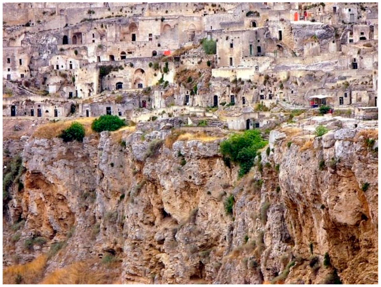
Figure 2.
The water reservoir system—Axonometric section [9].
Figure 2.
The water reservoir system—Axonometric section [9].
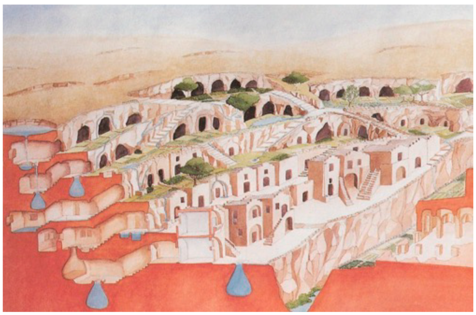
Figure 3.
The water reservoir system—Vertical section [9].
Figure 3.
The water reservoir system—Vertical section [9].
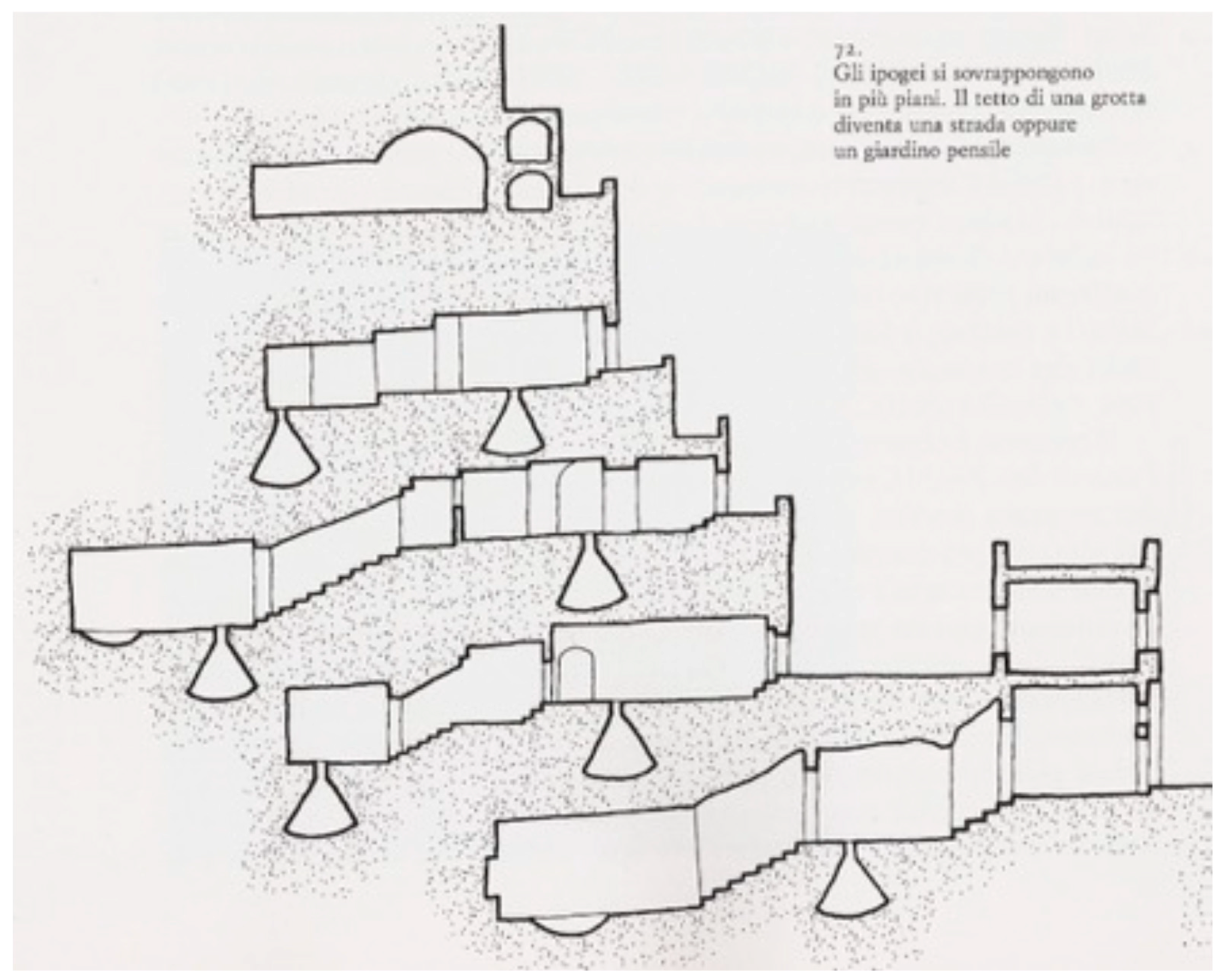
Figure 4.
Vittorio Veneto Square, with the church and monastery of St. Domenico (on the left) and the underground access to the “Palombaro Lungo” [10].
Figure 4.
Vittorio Veneto Square, with the church and monastery of St. Domenico (on the left) and the underground access to the “Palombaro Lungo” [10].
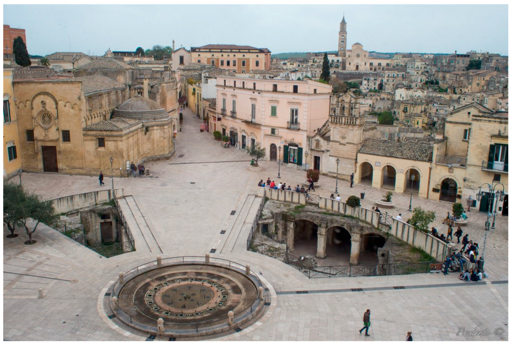
Figure 5.
The “Palombaro Lungo” reservoir in 1991 [11].
Figure 5.
The “Palombaro Lungo” reservoir in 1991 [11].
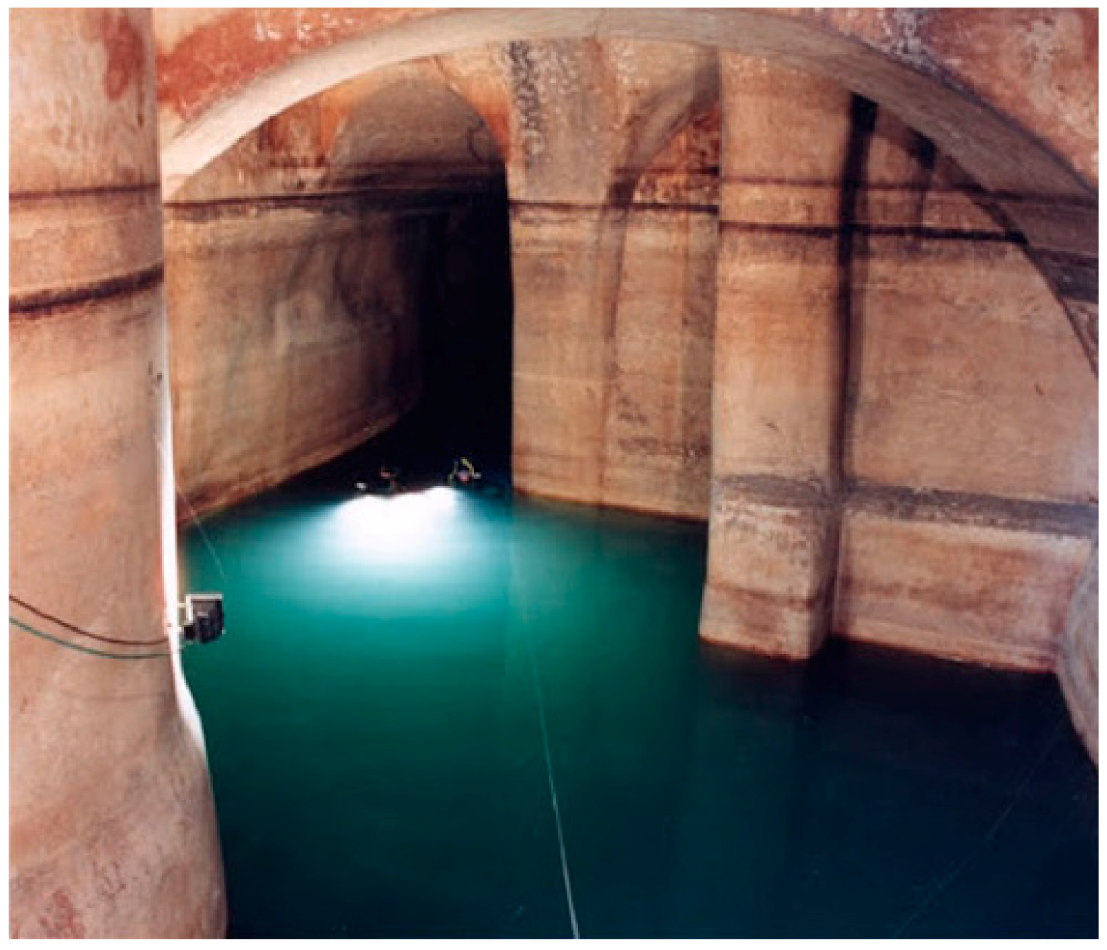
Figure 6.
Example of a 3-layer IoT architecture [21].
Figure 6.
Example of a 3-layer IoT architecture [21].

Figure 7.
IoT architecture (3-layer, 5-layer, modified 5-layer, 6-layer, 7-layer, FOG layer) [22].
Figure 7.
IoT architecture (3-layer, 5-layer, modified 5-layer, 6-layer, 7-layer, FOG layer) [22].

Figure 8.
FIWARE overall architecture [48].
Figure 8.
FIWARE overall architecture [48].

Figure 9.
IoT solutions architecture [52].
Figure 9.
IoT solutions architecture [52].
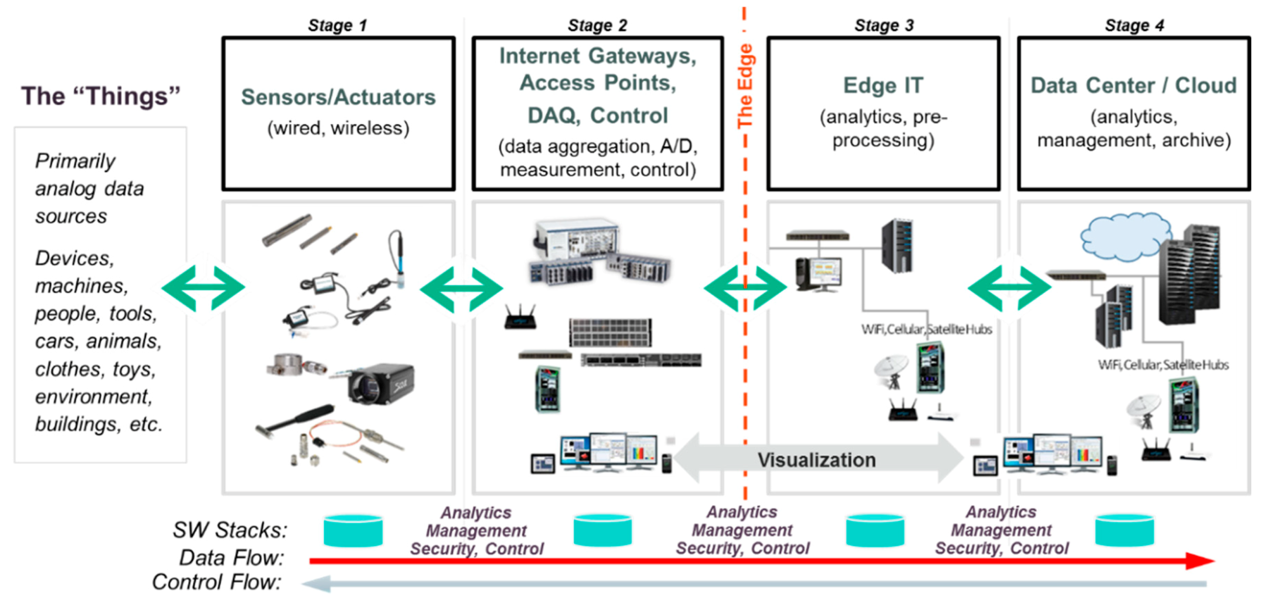
Figure 10.
IoT cross-domain interoperability [61].
Figure 10.
IoT cross-domain interoperability [61].
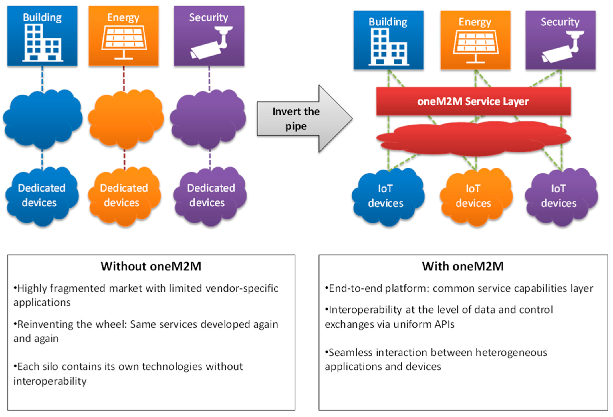
Figure 11.
The planimetry of S. Domenico Church and complex (It is located on the left of T2 and T9 points).
Figure 11.
The planimetry of S. Domenico Church and complex (It is located on the left of T2 and T9 points).
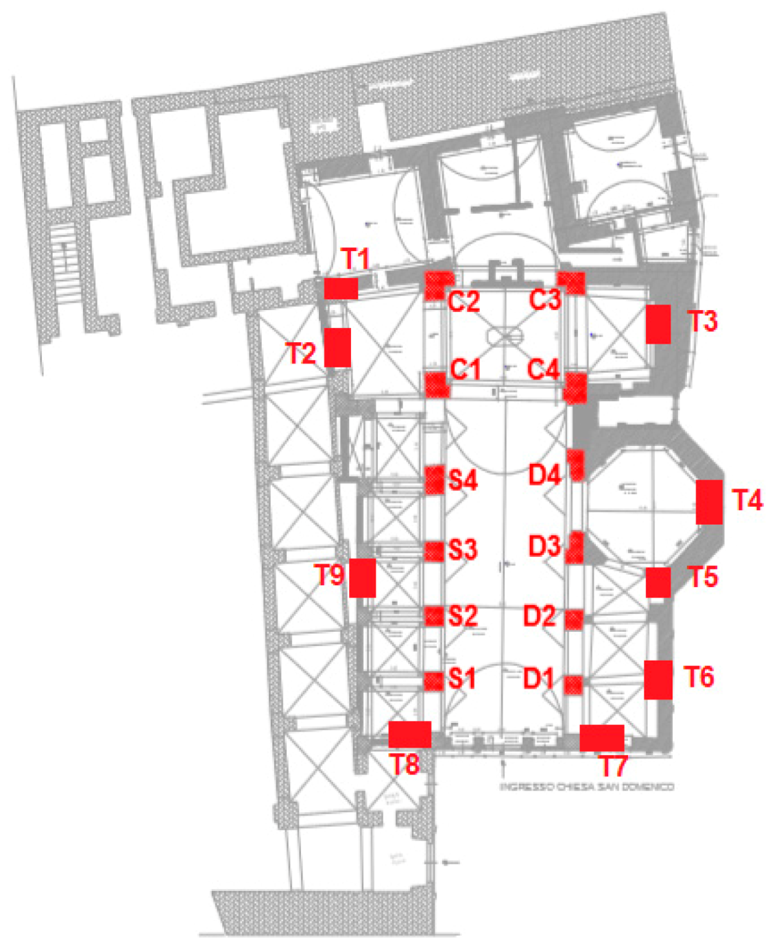
Figure 12.
Position of sensors in S. Domenico Church.
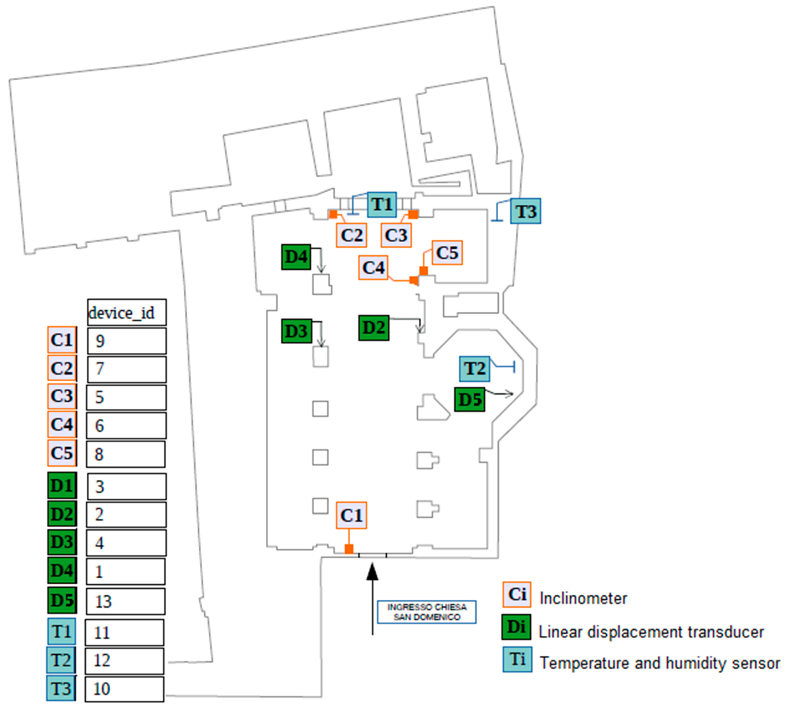
Figure 13.
IoT smart infrastructure architecture.
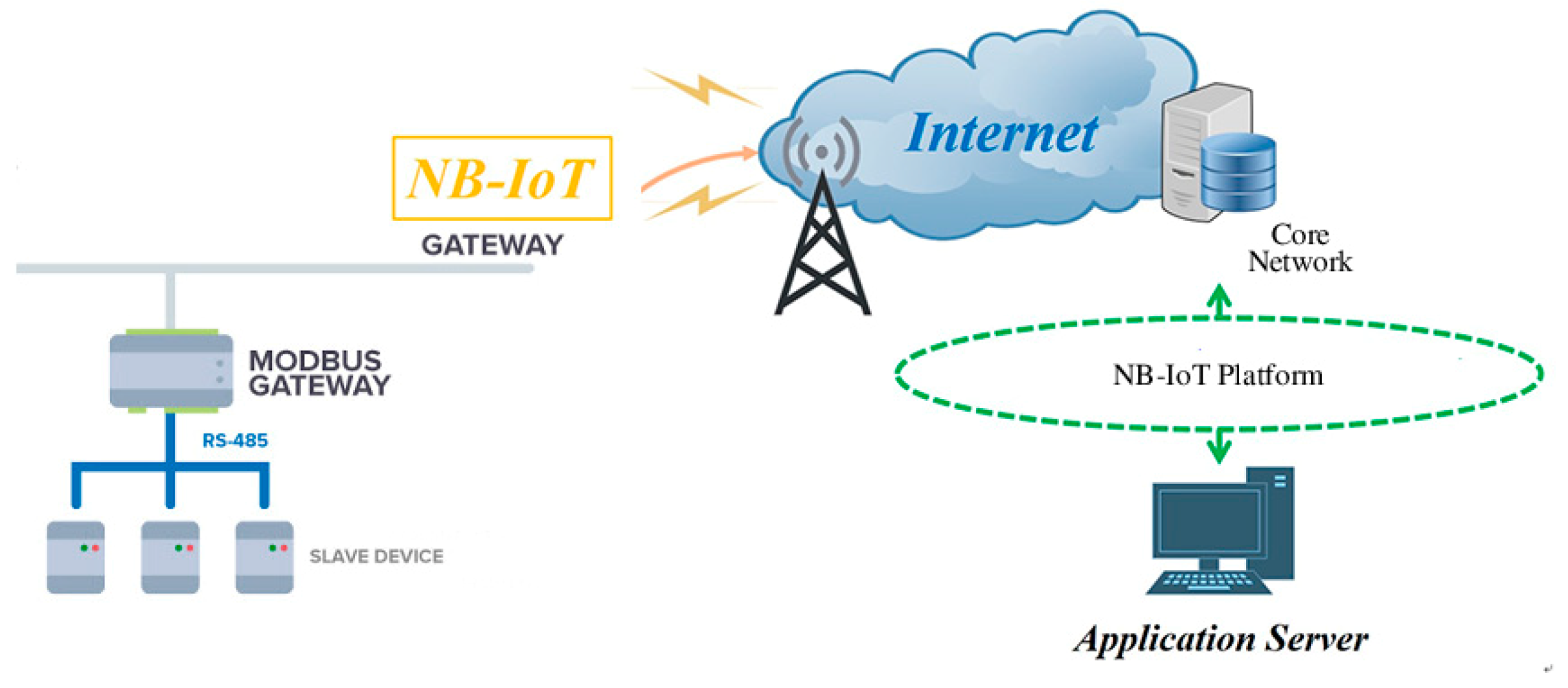

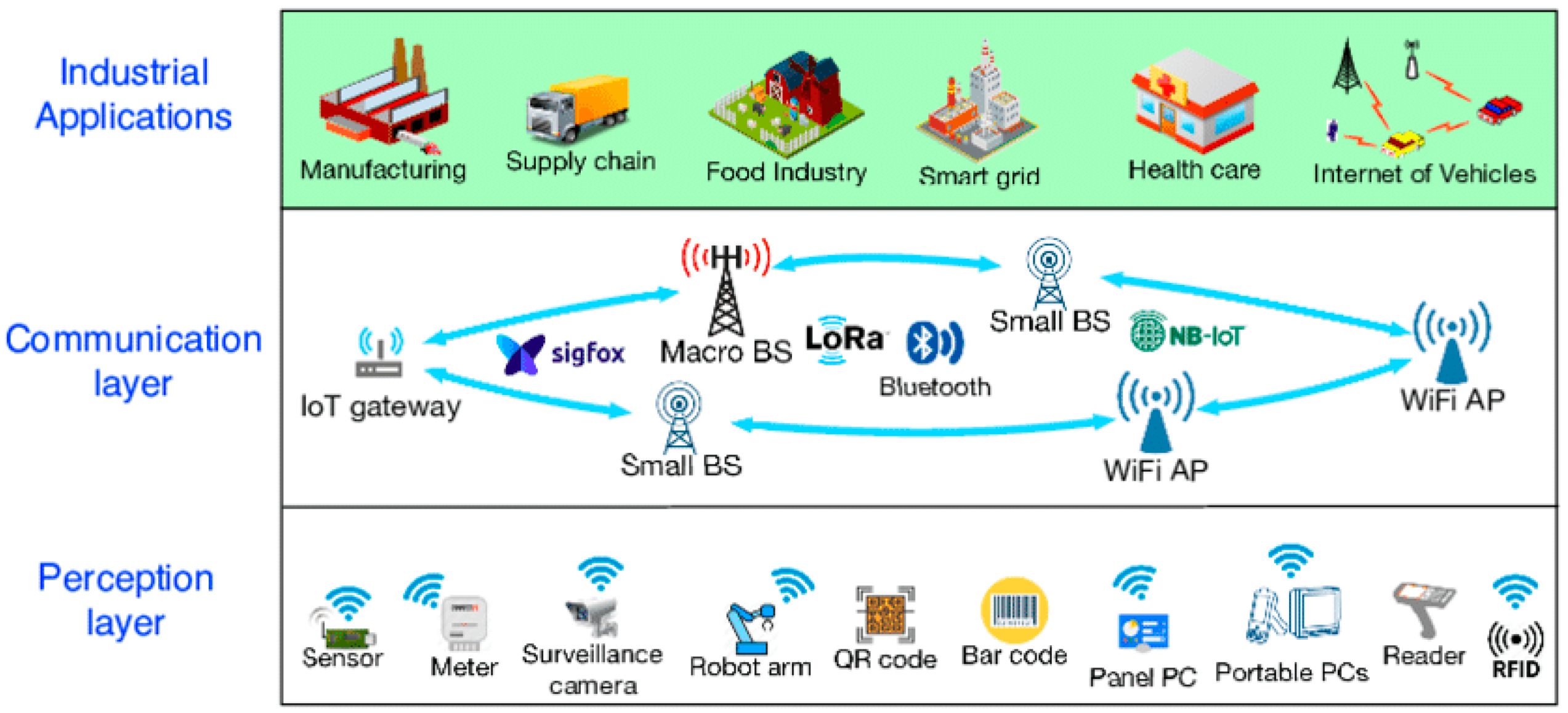
Table 1.
UNESCO List of factors affecting the properties [4].
Table 1.
UNESCO List of factors affecting the properties [4].
| Primary Risk Factors | Secondary Risk Factors |
|---|---|
| Buildings and Development | Housing |
| Commercial development | |
| Industrial areas | |
| Major visitor accommodation and associated infrastructure | |
| Interpretative and visitation facilities | |
| Transportation Infrastructure | Ground transport infrastructure |
| Air transport infrastructure | |
| Marine transport infrastructure | |
| Effects arising from use of transportation infrastructure | |
| Underground transport infrastructure | |
| Utilities or Service Infrastructure | Water infrastructure |
| Renewable energy facilities | |
| Non-renewable energy facilities | |
| Localized utilities | |
| Major linear utilities | |
| Pollution | Pollution of marine waters |
| Ground water pollution | |
| Surface water pollution | |
| Air pollution | |
| Solid waste | |
| Input of excess energy | |
| Biological resource use/modification | Fishing/collecting aquatic resources |
| Aquaculture | |
| Land conversion | |
| Livestock farming/grazing of domesticated animals | |
| Crop production | |
| Commercial wild plant collection | |
| Subsistence wild plant collection | |
| Commercial hunting | |
| Subsistence hunting | |
| Forestry /wood production | |
| Physical resource extraction | Physical resource extraction |
| Mining | |
| Quarrying | |
| Oil and gas | |
| Water extraction | |
| Local conditions affecting physical fabric | Wind |
| Relative humidity | |
| Temperature | |
| Radiation/light | |
| Dust | |
| Water (Rain/Water table) | |
| Pests | |
| Micro-organisms | |
| Social/cultural uses of heritage | Ritual/spiritual/religious and associative uses |
| Society’s valuing of heritage | |
| Indigenous hunting, gathering and collecting | |
| Changes in traditional ways of life and knowledge system | |
| Identity, social cohesion, changes in local population and community | |
| Impacts of tourism/visitor/recreation | |
| Other human activities | Illegal activities |
| Deliberate destruction of heritage | |
| Military training | |
| War | |
| Terrorism | |
| Civil unrest | |
| Climate change and severe weather events | Storms |
| Flooding | |
| Drought | |
| Desertification | |
| Changes to oceanic waters | |
| Temperature change | |
| Other climate change impacts | |
| Sudden ecological or geological events | Volcanic eruption |
| Earthquake | |
| Tsunami/tidal wave | |
| Avalanche / landslide | |
| Erosion and siltation/deposition | |
| Fire (wildfires) | |
| Invasive/alien species or hyper-abundant species | Translocated species |
| Invasive/alien terrestrial species | |
| Invasive / alien freshwater species | |
| Invasive/alien marine species | |
| Hyper-abundant species | |
| Modified genetic material | |
| Management and institutional factors | Management System/Management Plan |
| Legal framework | |
| Low impact research/monitoring activities | |
| Governance | |
| High impact research/monitoring activities | |
| Management activities | |
| Financial resources | |
| Human resources | |
| Other factor(s) |
© 2020 by the authors. Licensee MDPI, Basel, Switzerland. This article is an open access article distributed under the terms and conditions of the Creative Commons Attribution (CC BY) license (http://creativecommons.org/licenses/by/4.0/).
Share and Cite
MDPI and ACS Style
Lerario, A.; Varasano, A. An IoT Smart Infrastructure for S. Domenico Church in Matera’s “Sassi’’: A Multiscale Perspective to Built Heritage Conservation. Sustainability 2020, 12, 6553. https://doi.org/10.3390/su12166553
AMA Style
Lerario A, Varasano A. An IoT Smart Infrastructure for S. Domenico Church in Matera’s “Sassi’’: A Multiscale Perspective to Built Heritage Conservation. Sustainability. 2020; 12(16):6553. https://doi.org/10.3390/su12166553
Chicago/Turabian StyleLerario, Antonella, and Antonietta Varasano. 2020. "An IoT Smart Infrastructure for S. Domenico Church in Matera’s “Sassi’’: A Multiscale Perspective to Built Heritage Conservation" Sustainability 12, no. 16: 6553. https://doi.org/10.3390/su12166553
Note that from the first issue of 2016, this journal uses article numbers instead of page numbers. See further details here.