Review

Complexity of the Socio-Ecological Dynamics in Hong Ha Commune in the Vietnamese Highland—A Review through the Coupled Human and Natural Systems Framework

1
Laboratory of Forest Utilization, Graduate School of Agriculture, Kyoto University, Kyoto City, Kyoto Prefecture 606-8502, Japan
2
Department of Global Studies, Kyoto University of Foreign Studies, Kyoto City, Kyoto Prefecture 615-8558, Japan
3
College of Gastronomy Management, Ritsumeikan University, Kusatsu City, Shiga Prefecture 525-8577, Japan
4
Faculty of Architecture, University of Sciences, Hue University, 77 Nguyen Hue St., Hue City, Thua Thien Hue Province 530000, Vietnam
*
Author to whom correspondence should be addressed.
Sustainability 2020, 12(15), 6232; https://doi.org/10.3390/su12156232
Submission received: 18 June 2020 / Revised: 31 July 2020 / Accepted: 1 August 2020 / Published: 3 August 2020
(This article belongs to the Special Issue Environment-Poverty Nexus and Sustainable Development)

Abstract

:
In Vietnam, government policies have led to improvements in the national forest cover and poverty situation. However, numerous recent case studies in the Vietnamese highland found that socio-ecological dynamics were highly complex on a local scale, resulting in unintended policy impacts and varying policy success among regions. While such complexity has become apparent, it has been difficult to understand and compare between regions, as assessment methods and targeted aspects of socio-ecological dynamics differed between case studies. In this review, complex socio-ecological dynamics in Hong Ha Commune in Thua Thien Hue Province were identified in published case studies and organized into complexity features based on the coupled human and natural systems (CHANS) framework, to make information more accessible and comparable under the widely applied framework. All complexity features of CHANS systems were identified in the reviewed literature, such as feedback loops (between illegal forest use and flood damage), heterogeneity (in incomes between Kinh people and ethnic minorities), and telecoupling (of the local livelihood through tourism). Based on its applicability to Hong Ha Commune, the CHANS framework is suggested to be applied in other forested areas of the Vietnamese highland to understand and compare complex socio-ecological dynamics and evaluate policy impacts.

1. Introduction

The 2030 Agenda for Sustainable Development was unanimously endorsed by the international community in 2015 where it pledged to strive to realize a sustainable future by addressing the three dimensions economy, society, and the environment in a comprehensive manner [1]. In tropical and sub-tropical rural landscapes of developing countries, livelihood relies on forest utilization [2,3]. The majority of people living in or near forests in developing countries are poor [4,5]. Poor households, in particular, depend on physically accessible natural resources such as forests to cope with disaster-related income and subsistence losses [6]. At the same time, exploitation of forests in response to socio-economic pressures has been identified as a cause for rapid forest degradation in Southeast Asia [7]. Due to these and other interlinkages between forests and livelihood, Sustainable Development Goal 15 of the 2030 Agenda has specifically targeted the halting of deforestation, the restoration of degraded forests, and the promotion of sustainable forest management [8].
Vietnam has received great attention for its achievements in reversing deforestation and alleviating poverty [9,10,11]. Vietnam’s forests had been severely damaged by the Vietnam War and, later, by mismanagement of state forest enterprises, infrastructure development, government resettlement programs, and shifting cultivation [11,12,13]. To protect existing forests and reforest bare land nationwide, the Vietnamese government implemented forest land allocation (FLA) policies. With the Program 327 (1992), the Forest Protection and Development Law (1991), and the Land Law (1993), all Vietnamese forest was categorized and, henceforth, managed by government bodies or state organizations for either conservation (special-use and protection forest) or commercial wood production (production forest) [11]. In the long-term, part of the forest was to be allocated to communes and households, to encourage forest safeguarding and management for profits [11]. At the same time, poverty alleviation policies, such as Program 135 (1998) [14,15], provided investments to infrastructure, improvement of agricultural production, and social services [16]. Since 1990, the national forest cover in Vietnam increased from 27% [17] to nearly 42% in 2018 [18]. At the same time, the national poverty rate decreased from 37.4% in 1998 to 5.8% in 2016 [19]. These nationwide numbers indicate that government action had led to effective improvements in the forest cover and the poverty situation in Vietnam.
On a local scale, however, case studies revealed varying policy success among highland communes. Some case studies reported overall positive effects on forest resources and livelihoods [20,21]. Other case studies, however, reported continued degradation and deforestation of natural forests following the implementation of FLA policies, while only commercial tree plantations increased in area [10,22,23,24]. Furthermore, improvements in the local livelihood were reported to be either small [23] or disproportionally larger for some population groups compared to others, such as for Kinh people, the ethnic majority in Vietnam, compared to ethnic minority members [10,25]. Such varying policy success among highland communes was often the result of complex socio-ecological dynamics. For instance, feedbacks between flood damage, food insecurity, and illegal forest use promoted forest degradation [23]; the heterogeneity in slopes and elevations across the hilly landscape of the Vietnamese highland affected land use decisions [20,25]; or the improvement in livelihood of population groups was coupled to their access to markets for wood or agricultural products [10,20,25]. While great efforts have been made to identify these complex socio-ecological dynamics, case studies varied widely in their assessment methods and could only address certain aspects of socio-ecological dynamics in a local context. In line with previous calls [26,27], a common framework to organize and analyze the findings from various case studies is needed, in order to effectively address and understand the complex socio-ecological dynamics in highland communes of Vietnam.
One framework to grasp the dynamics in complex human and natural systems is the coupled human and natural systems (CHANS) framework rooted in political science and natural resource management. The CHANS framework is integrative and inter/trans-disciplinary across the social and natural sciences and facilitates understanding of spatial, temporal, and organizational, interactions between humans and the natural environment [28,29]. The CHANS framework can be used to organize complex socio-ecological dynamics in a local context within so-called complexity features: reciprocal interactions and feedback loops; non-linear relations and thresholds; surprises; heterogeneity; telecoupling; vulnerability; and time lags and legacy effects [29,30]. Such organization has functioned as an effective tool to reveal the impacts of land use policies in China and Nepal [29] and made knowledge on socio-ecological dynamics more accessible and comparable between regions despite great differences in local contexts, such as the economic development status or the type of natural resources [30]. The application of the CHANS framework has, therefore, the potential to support the search for more effective policies for forest management and restoration in Southeast Asia. In communes of the forested highland of Vietnam, however, the analysis of complexity features with the CHANS framework has not been applied, yet.
In this review, we aim to reveal the impact of the Vietnamese FLA policies on socio-ecological dynamics in the local context of a forested highland commune. For this, the CHANS framework was used to identify and organize complex socio-ecological dynamics in published literature on Hong Ha Commune in Thua Thien Hue Province. It was hypothesized that the outcomes of the FLA policies in the local context were more complex and varied than suggested by simple nationally applied indicators such as forest cover and poverty rate. With this study, we attempt to show how the outcomes of Vietnamese land use policies may be comprehensively understood and how gained knowledge may be made more accessible and comparable between regions across Southeast Asia, in order to support the search for more effective policies for forest management and restoration. Hong Ha Commune was chosen as a study site, as (1) the commune participated in all major policy programs by the Vietnamese government related to forest protection and restoration, agricultural development, and poverty alleviation in recent decades as well as numerous non-governmental development projects [31,32]; (2) the impacts of FLA policies were significant, as nearly the entire commune area was declared protected forest land due to the commune’s key location in the upstream area of the densely populated Hue City and the surrounding agricultural plain [33,34]; and (3) various aspects of the commune’s livelihood and land use following the implementation of national policies were independently studied by various research groups in different scientific disciplines, which resulted in a high number of qualitative and quantitative case studies that could be comprehensively analyzed through the CHANS framework.

2. Materials and Methods
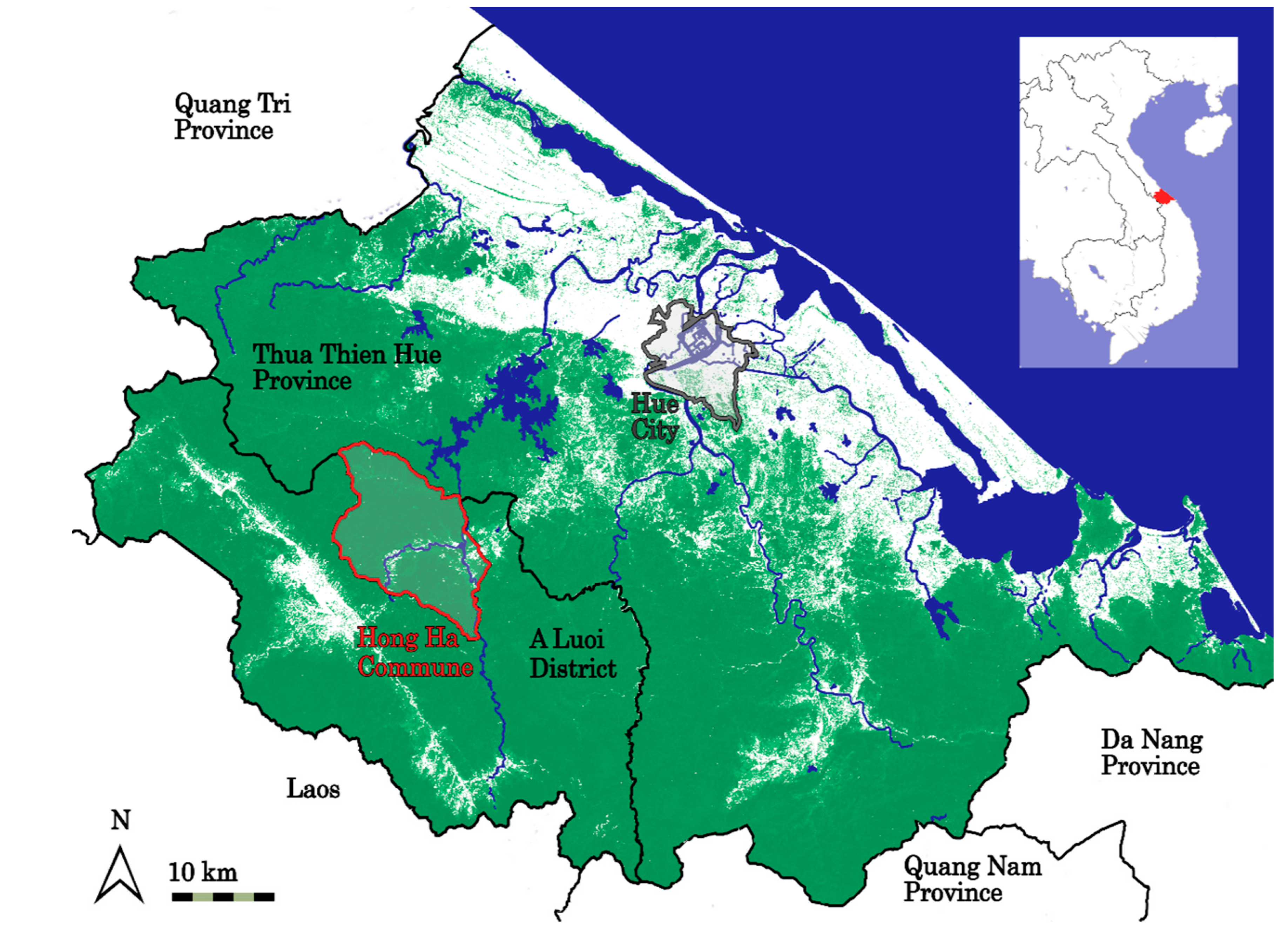
2.1. Study Area

Hong Ha Commune of A Luoi District comprises an area of 14,047 ha in the highland of Thua Thien Hue Province, North Central Vietnam [35]. The commune area is part of the forested watershed of the Bo River, which represents an important freshwater resource of the more densely populated coastal region of Thua Thien Hue Province (Figure 1). The local climate is a hot and humid tropical monsoon climate with about 3500 mm annual precipitation. The rainy season lasts from September to December with frequent typhoons in October and November [36]. The natural vegetation in the study area is tropical moist forest [33]. The commune area is part of the ecoregions Northern Vietnam Coastal Moist Forests and the Annamite Range Moist Forests [33,37,38]. Local natural and semi-natural forests, consisting of primary forests with medium disturbances and secondary forests in mature states, have a continuous canopy layer at a height of 20 to 30 m. The forests are a significant biodiversity hotspot [33]. In 2005, 104 tree species in 43 plant families were recorded [34]. Dominant tree species are evergreen broad-leaf trees of the plant families Fagacea (Quercus platycalyx, Lithocarpus ducampii, Castanopsis indica, Quercus myrsinaefolia), Magnoliaceae (Michelia balansae, Michelia mediocris), Lauraceae (Cinnamomum tonkinense), Myrtaceae (Syzygium zeylanicum), Annonaceae (Polyalthia nemoralis), and Malvaceae (Scaphium macropodium) [33]. Furthermore, the forests are providing habitat to rare and endangered tree species valued for their timber such as Erythrophloeum fordii, Sindora tonkinensis, and Hopea pierrei [31,34] as well as 32 species of mammals and 51 species of birds [39]. Rare fauna includes endangered gibbon species (Nomascus sp.) and the critically endangered saola (Pseudoryx nghetinhensis, a forest-dwelling bovine [31,40,41].
Hong Ha received its status as a commune of A Luoi District after the Vietnam War ended in 1975 [31]. Through national resettlement policies, the population grew significantly from 300 in 1975 to 675 in 1985 and 1100 in 1998 [31]. In 2017, Hong Ha had a population of 1632 people in 416 households distributed over five villages [44]. More than 90% of the population belong to ethnic minorities, the Katu, Ta Oi, Pahy, Paco, and Bru-Van Kieu, which had originally been resettled to the commune from surrounding highland areas to encourage a sedentary livelihood. Less than 10% of the population are Kinh, the ethnic majority in Vietnam, which had mostly migrated to the commune from urban areas in the lowland [32,45].
Traditional livelihood of ethnic minorities in Hong Ha depended on forest utilization. Locals conducted shifting cultivation: forest patches were slashed and burned to cultivate crops for 2–4 years, before letting the forest regenerate for 15 years [46]. Additionally, fuel and construction wood as well as various non-timber forest products such as rattan, fruits, or herbs were extracted [31,34]. However, during the Vietnam War until 1975 significant portions of the commune’s forests were destructed by chemical defoliants and bombs [31]. Following the in-migration and growth of the commune population after 1975, forest utilization had increasingly negative effects on the coverage and quality of the already damaged commune forests [31]. Data on the commune’s forest cover before 1991 is unavailable and even for the early 1990 published data remains scarce and inconsistent. Nevertheless, interviews with locals indicated that, in 1945, almost all of the commune area had been covered with natural forest [31]. Depending on the source, the commune area’s forest cover in the early 1990s was between 69%, estimated for 1991 [34], and 56%, estimated for 1992 [31].
Under the FLA policies by the Vietnamese government intended to protect existing forests and reforest bare land nationwide, the control over all of Hong Ha’s forest was transferred to the Bo River Water Management Board of the province’s Department of Agriculture and Rural Development in 1991 [34,47,48]. Hillside land was claimed for forest protection and afforestation, while land along the commune’s main road was claimed for plantation forestry, severely restricting the access to the forest by the local population. By 2007, only about 16% of the claimed area had been allocated to the commune [34]. Applications by households for forest land were usually unsuccessful or took years to be processed [32]. Through the FLA policies, the commune’s forest cover increased significantly to 86% in 2007 [34]. For 2017, a forest cover of 78% was reported [44].
Hong Ha has been one of the poorest communes in A Luoi District [49,50]. In 1999, ca. 60% of the population was poor [15]. Household surveys in 1998 and 2000 showed that the lower the income level of a household the higher its relative income is derived from forest resources [31]. To provide the local population with means of livelihood other than the traditional extraction of forest products, households in Hong Ha received payments for planting trees on claimed forest land as well as loans and subsidies to establish forest plantations, mainly Acacia trees, along the main road [32,46,51]. Furthermore, households were allocated agricultural land along the river and supplied with agrochemicals and training for livestock and crop production [31,47]. Campaigns for planting crops such as sugarcane, cinnamon, pepper, or pineapple were conducted [46]. Finally, infrastructure, such as roads and irrigation systems, was upgraded as part of the nationwide poverty alleviation plan “Program 135” implemented from 1998 [14,15]. While clear attribution of the program remains unestablished, the poverty rate in the commune population was decreased to 47% in 2004 [15]. In 2017, 30% of households were reported to be poor, indicating an even lower poverty rate in the population [44].

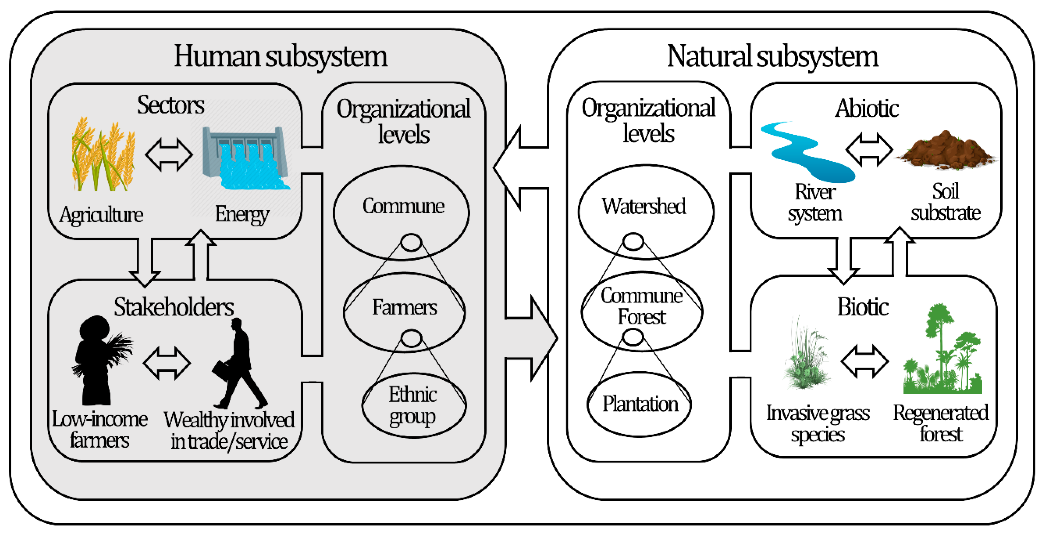
2.2. The CHANS Framework

Considering data on the forest cover and poverty rate alone, government policies led to an effective change in resource use in Hong Ha Commune while supporting the livelihood of the local population. However, socio-ecological systems are usually complex webs of interactions [29,30,52], which demand a conceptual framework rather than simple indicators such as forest cover and poverty rate for better understanding. Among frameworks for the analysis of social-ecological systems, several types were identified that differ in the extent to which they describe different components of socio-ecological systems [52]. While “ecocentric frameworks”, for instance, give a better account of the ecological component of a socio-ecological system with focus on energy flows and services of natural ecosystems, “integrative frameworks” tend to give a better account of the structure of and feedbacks within the social component [52]. The applied framework type varies depending on the purpose of a study [52]. “Integrative frameworks” were specifically recommended to study complex socio-ecological issues related to the natural resource utilization in rural communities and how such utilization can be made more sustainable [52]. In this study, the coupled human and natural systems (CHANS) framework, an integrative framework [28,53] (Figure 2), was chosen to better capture the complex social dynamics in Hong Ha Commune in response to national land use policies. In contrast to other “integrative frameworks”, the CHANS framework has the advantage that it explicitly specifies the interactions between multiple socio-ecological systems through telecoupling [28], which appeared useful for Vietnamese highland communes, which closely interact with other regions through migration, tourism, or trade.
In coupled human and natural systems (CHANS), or simply “coupled systems”, interactions and feedbacks between the human and the natural subsystem are identified (Figure 2). The human subsystem consists of diverse stakeholders and sectors, which may cooperate to solve common problems or compete for resources [28]. In the case of Hong Ha, stakeholders are, for instance, ethnic minority farmers or the Bo River Water Management Board, sectors may the agricultural or energy sector. The natural subsystem consists of abiotic and biotic components, such as the primary forest with rare and endangered tree species, Acacia plantations, or the Bo River system in Hong Ha. Biotic components interact and rely on abiotic components for growth, survival, and reproduction [28]. In the human and the natural subsystem, interactions between components occur at the same or across different organizational levels [28] (Figure 2). Furthermore, interactions occur between multiple coupled system in the form of, for instance, migration, tourism, and trade [28,54]. These interactions evolve over time and affect the socio-ecological dynamics within each of the interacting coupled systems, such as local income structures or forest compositions [28]. Socio-ecological dynamics within and between coupled systems are described by complexity features, i.e., (1) reciprocal interactions and feedback loops; (2) non-linear relations and thresholds; (3) surprises; (4) heterogeneity; (5) telecoupling; (6) vulnerability; and (7) time-lags and legacy effects [29,30,53]. In this study, these complexity features are used to analyze policy outcomes on socio-ecological dynamics in the local context of a forested highland commune in Vietnam.

2.3. Literature Review

For the literature review, Google scholar searches (https://scholar.google.com) were conducted using the keywords “Hong Ha Commune”, “Hong Ha A Luoi”, “Hong Ha Thua Thien Hue”, which yielded ca. 14,000 hits in total. The first thousand hits of each search were scanned for literature that focused on or specifically mentioned Hong Ha Commune. Additional searches in the academic databases AGRIS (https://agris.fao.org), JSTOR (https://www.jstor.org), and Web of Science (https://webofknowledge.com) did not yield additional literature. Only a few additional resources that had not been published online had been attained by the authors due to past involvement in research in Hong Ha. From all literature, case studies in the form of peer-reviewed articles in scientific journals and conference proceedings (n = 18), book sections and reports from internationally recognized organizations (e.g., International Development Research Centre, Asian Disaster Preparedness Center; n = 15), and graduation theses from recognized university in international academic rankings were selected (n = 5). Additionally, satellite data was attained from two sources [42,43]. The scope of the conducted literature review had limitations. Firstly, only publications that were written in English or included an English summary were reviewed, as their content can be verified and further studied by the international scientific community. Reference lists in the reviewed literature, nevertheless, indicated that the vast majority of information on Hong Ha Commune has been published in English. Secondly, publications that did not specifically mention Hong Ha were excluded. This may have led to an underrepresentation of information gathered on broader scales, such as the assessments of ecosystem dynamics across eco-regions or province-wide population dynamics. In cases where commune-specific information was lacking, studies with broader regional scales were occasionally referenced, but related analyses are limited in depth.
All selected case studies were categorized by type (agent-based model analyses, qualitative descriptions, framework applications, natural resource assessments with and without GIS) and main theme (forests and agriculture, ethnic culture, livelihood and poverty, disaster vulnerability, tourism). Subsequently, paragraphs addressing the local forest’s structure and development, the population’s structure and development, the population’s dependency on forests, the population’s impact on forests, natural disasters, implemented government policies, non-governmental development projects, and migration were extracted and combined by topic to ease the recognition of relationships and dynamics covered by the CHANS framework and to cross-check information between publications. Among the selected 38 case studies, four ended up not being referenced in the article. Case studies not referenced are listed in the Supplementary Materials.

3. Results and Discussion

3.1. Reciprocal Interactions and Feedback Loops

In coupled systems, people and nature interact reciprocally. Thereby, feedback loops are generated [29,30]. In Hong Ha Commune, as explained earlier, forest utilization by the growing local population has caused decreases in the coverage and quality of commune forests after the Vietnam War [31,32]. As reported in previous studies, the resulting decrease in the forest cover has increased soil erosion and the frequency and intensity of landslides during floods, with severe negative effects on the local population [15,49]. During major floods in 1999 and in 2007, soil, sand, and gravel were deposited on much of the agricultural land near the river, making the land unusable for several months [15,45,49]. In 1999, all paddy land was covered with thick layers of sediments, ca. 13% of paddy land and 40% of dry land was lost, and 20% of growing cassava and 43% of growing sugarcane were destroyed [15]. Damage to the agricultural land, reciprocally, increased the dependency on forests by the local population, which seemingly enhanced illegal logging and clearance of forest for shifting cultivation: pressure on forests through illegal logging was reported to have increased after 1999 [32,34]. Therefore, flood damage to agricultural land and population pressure on forests may represent a positive feedback loop.
FLA policies have likely reinforced this positive feedback loop: by claiming all hillside land for forest protection and reforestation, agricultural land became limited to only 100–150 ha in the flood-prone river area [31,48,49]. Consequently, the vulnerability of the local livelihood to flood-related damages was increased. While the poverty rate in the commune has decreased between 1999 and 2017 [15,44], high vulnerability to flood-related damages caused temporary poverty in the population: eight household faced poverty after the flood in 1999 had destroyed all their paddy land [15]. Furthermore, the number of households facing food insecurity in and around Hong Ha has remained high. After the flood in 1999, 79% of households had insufficient food [15]. In survey results published in 2014, 78% of households in Hong Ha (1999) and six other communes of A Luoi District had insufficient food [55,56]. Efforts by the commune to mitigate the unanticipated detrimental effects of FLA policies in cooperation with district and provincial governments, such as proposals for the intercropping of trees and food crops on hillside land, have mostly been rejected [55]. Hence, locals have either ignored restrictions by the FLA policies and continued agriculture on hillside land—the enforcement degree of protection zones was estimated to be only 50% [47]—or established income sources other than agriculture such as the ecotourism program established in 2016 [57]. There are also a few locals who migrate to other areas for work [15]. Changes release pressure on the forest and are examples for a negative feedback loop.

3.2. Non-Linearity and Thresholds

In coupled human and natural systems, relationships are often non-linear [29,30]. A common way to quantitatively assess relationships in coupled systems is to apply multi-agent models, which simulate human and landscape agents, which interact with each other. Landscape agents represent spatial landscape units that host natural processes such as crop and forest growth [58,59,60].
In Hong Ha, the multi-agent model-based “Land Use Dynamic Simulator” (LUDAS) was applied to assess land use and land cover change based on field data from 2002 [33,47]. An important determinant of land use dynamics is crop yield and its influencing factors. In yield models for paddy land (paddy rice) and hillside crop land (upland rice, peppers, pineapple, cassava, etc.), crop yield was found to significantly positively respond to inputs of labor and agrochemicals. However, the response of crop yield, in line with the law of diminishing marginal returns [61], became smaller as inputs became larger (represented by a power function that concaves down: y = axb with a > 0 and 0 < b < 1) [33]. The response of crop yield to agrochemical input was about 10 times smaller than the one to labor input, indicating that the level of agrochemical input in 2002 was already close to a saturation level. Accordingly, a LUDAS-based simulation of land use policy options for Hong Ha revealed that an increase in agrochemical supply would not significantly increase agricultural productivity or household incomes over a period of 20 years [47]. Hence, agrochemical supply by the government, while being an effective measure at current levels, bears little potential for further improvement in the agriculture-based livelihood in Hong Ha.
Furthermore, crop yield in hillside crop land and fruit tree land (banana, lemon, jackfruit trees, etc.) responded to the cropping year in a non-linear fashion, i.e., changes in the crop yields were most significant during initial cropping years (Figure 3). The strong initial decrease in crop yield on the hillside land is typical for shifting cultivation and in line with the practice of villagers to fallow hillside crop land after 2–4 years [33,46]. The strong initial increase in the crop yield from fruit tree land, on the contrary, highlights fruit tree cultivation as profitable land use option in the mid- and long-term. Commune leaders in Hong Ha have long realized the good long-term prospects that fruit tree land provides [55]. However, the agricultural land of the commune is too scarce for farmers to afford fruit tree production in addition to the production of annual crops [55]. When petitioning the province’s government to be allowed to intercrop fruit trees and annual crops, commune leaders have mostly been rejected [15,48,55]. Under current regulations, land may either be used for trees (forest land) or annual crops (agriculture land) [55].
Non-linearity in coupled systems often involves spatial or temporal thresholds at which states of system components abruptly change [29]. For instance, LUDAS-based estimates suggest that through labor constraints and physical inaccessibility, areas more than 2 km away from roads, and settlement areas, would be protected from forest cover loss if all forest protection policy were suspended [47]. Moreover, satellite image data [42] suggest that forest loss mostly occurs within close distance to the settlement area (Figure 4). Furthermore, thresholds were identified in forest regeneration after cultivated hillside land is fallowed. For forest to naturally regenerate, fallowed land needed to be within 20–30 m from a natural forest edge [33]. Otherwise, rapidly spreading Imperata grasses block natural regeneration for long periods of time. Within 20–30 m from a natural forest edge, fallowed land will recover in succession stages: grassland develops to shrubland in about 1–3 years; shrubland develops to young forest in about 7–9 years [33]. Thresholds such as the ones above call for a much more granular forest protection policy, which, instead of protecting all hillside land equally, allows for agricultural production in amounts tolerable to the natural environment. For such a policy, the existing system of government agencies to determine forest protection zones, which is solely based on environmental factors such as precipitation, slope, relative elevation, and soil physical conditions [47], must be complemented with knowledge of agricultural production, vegetation development, and their interaction. The integration of such knowledge would likely require a greater involvement of scientific tools, such as land use simulations and remote sensing, as well as an improved dialogue of government agencies with local ethnic minority farmers who have accumulated a significant amount of traditional knowledge on vegetation succession, soil fertility, and intercropping [31]. Allowing for agricultural production in amounts tolerable to the natural environment and involving local farmers into the development and implementation of forest protection policies would likely improve the local acceptance of such policies. A major problem of current forest protection policies is that their enforcement degree is low [47]. Commune and district governments have little power to stop illegal logging across the vast commune land [32,34]. Greater local acceptance of forest protection policies would likely reduce the need for the cost-intensive but ineffective monitoring of forests by local staff and enable a shift to a cheaper regular analysis of satellite data to identify remaining key areas of illegal logging.

3.3. Surprises

If complex socio-ecological dynamics such as feedback loops are not understood, some dynamics within coupled systems may be surprising [29,30]. For instance, the quality of the forest cover in Hong Ha Commune decreased following the introduction of strict forest protection policies in 1991. Between 1991 and 2007, areas of poor natural forest increased, while areas of medium and rich natural forest decreased (Figure 5) [34]. While the area of plantation forest increased simultaneously (Figure 5), the establishment of forest plantations did not contribute to the loss in medium and rich forest, as all plantations were established on bare land in close proximity to the settlement [34]. Instead, the primary cause for the drop in forest quality was a conversion of rich and medium forest to poor forest through illegal logging [34] which could not be stopped due to a lack in the necessary personnel of local authorities [31,32]. As explained in Section 3.1, illegal logging is likely a feedback to the frequent flood damage to agricultural land. Accordingly, forest quality decreased more severely after ‘floods of the century’ in 1999 than before (Figure 5). Nevertheless, the establishment of forest plantations will likely put additional pressure on natural forests in the future. In 2007, only 990 ha of the former 3760 ha of bare land in 1991 were left [34]. Hence, further extension of plantation forestry would, at some point, require the replacement of natural forest. Recent satellite data shows a forest loss outside of the plantation area designated in 2007 (Figure 4), does, however, not reveal its causes. Natural forests have important ecosystem functions, such as the provision of food and fiber, the regulation of the water quality and run-off, the regulation of the climate by greenhouse gas sequestration and exchange of water and energy with the atmosphere, the provision of health services, the harboring of biodiversity, and replenishing of soils with nutrients [37,62]. The conversion of natural forests would alter these functions, leading to increased water run-off and flood severity, increased emission of greenhouse gases to the atmosphere, degradation, and fragmentation of habitats, and soil nutrient loss through soil erosion [62]. In Hong Ha, forest conversion was, for instance, reported to have reduced the soil fertility remarkably [33]. Reforestation of formerly natural forest land with forest plantations is unable to sufficiently rehabilitate these important ecosystem functions of natural forests [37].
Another surprising change in Hong Ha is the decrease in the average household size from about six members in 1998 to four members in 2017 (Figure 6). A decreasing average household size is surprising, because larger households can invest more labor into crop production and the management of Acacia plantations, which is advantageous in both cases [32,33]. At the same time, larger households need to maintain less housing facilities and, hence, save valuable fuelwood and building materials [32]. One potential reason for the decrease in household size in Hong Ha is the bad implementation of land use laws. Land boundaries in the settlement area remain unclear and poorly enforced, which enables small households such as the ones of newly married couples to settle freely on new lands and establish new Acacia plantations [32]. Other potential reasons are a change in social norms, such as an increasing preference of young people to leave parental homes or an increasing acceptance of divorces, similar as in Wolong (China) [63], or the effects of the national two-child policy proclaimed in 1988 [64]. Nevertheless, an implementation of the two-child policy in Hong Ha was not mentioned in the reviewed literature and, hence, may have had little significance for commune households. Indeed, in the nearby Nam Dong District, the two-child policy was implemented as late as 2010 [65], indicating a lax implementation in the highland of Thua Thien Hue Province. Migration is another important factor for demographic change. In-migration, however, likely contributed little to the increase in the household number after 1999, as migration to Hong Ha was reported to have gradually decreased between the national resettlement policies in the 1970s and 2008 [32]. Furthermore, out-migration has likely contributed little to the decrease in the average household size from 1999. While out-migration, in the form of temporary labor migration is an important coping strategy after natural disasters in highland areas [66], field surveys in Hong Ha Commune between 2000 and 2004 indicated that few locals migrated for work to other areas after 1999 [15]. One potential reason for this may have been that households needed all available labor for food production [15]. For the protection of forest resources in Hong Ha household size matters, as smaller households have a larger resource demand per capita, leading to an overall larger impact of the total population on forests at the same population size. In coupled systems in Wolong (China) and Chitwan (Nepal), household proliferation was linked to environmental degradation, contributing to decreases in wildlife habitat [29].

3.4. Heterogeneity

In coupled systems, socio-ecological dynamics vary spatially, temporarily, and across population groups [29,30,33]. For instance, the hilly landscape of Hong Ha Commune shows high spatial heterogeneity in the slope gradient. Slope gradients vary from below 5° in the flat land around the river to up to 25° in steeply sloped hillside land [33]. LUDAS-based estimates suggest that a doubling in the slope gradient of hillside crop land, with all other factors unchanged, leads to a significant reduction in the crop yield by ca. 27%, due to higher soil erosion on steeper slopes [33]. The resulting variation in crop yield across the landscape was suggested to contribute to the uncertainty among hillside farmers over what crop yield they can expect and, thus, limit their learning behavior in regard to land use [67]. Instead of making land use choices based on foreseeable outcomes of land use choices, they were more likely to change their land use strategy based on their current economic condition and the behavior of other farmers [67], which complexifies the response of farmers to land use policies. The significant amount of traditional knowledge on crop cultivation local farmers of ethnic minorities have accumulated certainly supports their decision-making in land use [31]. In the traditional land use system, the suitability of land for crop cultivation is determined by various factors including the slope gradient [31]. Land with a high slope gradient is commonly avoided or only cultivated for a small number of years to limit the impact of soil erosion [31]. Nevertheless, the strict forest protection policies, the growing local population, and the establishment of plantation forests have severely reduced the amount of land available to each farmer for crop cultivation, which has forced farmers to reduce fallow periods and use otherwise unsuitable land [31,32,33,68]. This has reduced the farmers’ ability to apply their traditional knowledge and, instead, required the unfamiliar application of modern fertilizers, pesticides, and irrigation systems [31]. In order to help farmers making better land use choices in the altered landscape, there have been considerable efforts by international organizations to develop and implement participatory farming approaches that merge traditional knowledge with modern farming techniques and new crops, such as the cassava project by the Nippon foundation or the vanilla project by Hue University and Kyoto University [14,69,70,71,72,73]. Recent, expert surveys in 2017 and 2018 indicated that farming skills in Hong Ha have, indeed, surpassed the ones in many neighboring communes [74].
Furthermore, the impact by governmental development projects on the local population is spatially heterogeneous. When a large hydropower plant was built near the eastern commune border in 2010, the project occupied land belonging to inhabitants of the Arom village [32] and forced inhabitants of the Pa Rinh village to permanently move due to the flooding of their land [48]. Both of these villages, hence, faced severe restrictions in land access due to their location. A similar spatially heterogeneous impact on the local livelihood through the development of a hydropower plant was reported in Binh Thanh Commune of Thua Thien Hue Province [75].
Temporal variation in human-nature interactions in Hong Ha has become apparent in surveys on household livelihoods. In surveys in 1998 and 2000, agriculture contributed 40–77% to the total economic output of Katu, Paco, Ta Oi, and Pahy households [31]. In 2008, after Acacia plantations had proliferated within the commune and timber market access had improved [32,34], more than 70% of the population were engaged in Acacia cultivation, while nearly 50% were assumed to derive their livelihood mainly from the production and sale of Acacia trees [32]. From 2016, a local ecotourism program became a new source of income. In 2017, locals that participated in running tourism facilities such as a traditional community house reportedly earned 520,000 VND per person and month between March to August (ca. 23 USD as of 2017) [44]. Such an income is close to the monthly income per person of rural households at the poverty line of 700,000 VND according to national wealth indicators [76]. The tourism program’s potential as an income source may, therefore, contribute to a shift from agriculture and forestry to service-related occupations, similar as in Wolong (China) and Chitwan (Nepal) [29]. This shift would severely affect the coupling of people and their natural environment in Hong Ha Commune.
Means of livelihood also vary across the population. While ethnic minorities dominate the local population, just under 10% of people are Kinh people, the ethnic majority in Vietnam [45]. Kinh people have mostly migrated to the commune from urban areas and are commonly involved in service and trade businesses [44,45]. In surveys in 1998 and 2000, service-related activities contributed 77–82% to the total economic output of Kinh households, while they contributed only 0–22% to households of ethnic minorities [31]. Hence, Kinh households have been less vulnerable to flood-related damages to agricultural land. Kinh households are involved in Acacia production and sales but often have advantages compared to ethnic minorities. It is not uncommon that they manage plantations of 5–6 ha, while ethnic minority households commonly manage only 1–2 ha [32]. Furthermore, Kinh households received 9–19% higher prices per ha of Acacia plantation in 2008 compared to ethnic minorities, which was partially due to better bargaining skills [32]. For the recent tourism program, available literature did not specify to which degree different ethnic groups participated and profited. However, the tourism concept focuses in a large part on the culture and traditions of ethnic minorities [44] and may, therefore, primarily involve and profit ethnic minority members.

3.5. Telecoupling

Coupled systems such as the one of Hong Ha are typically interconnected with other systems through socio-economic and environmental interactions over distances [54,77]. For instance, the watershed of the Bo River connects Hong Ha with the more densely populated lowland of Thua Thien Hue Province (Figure 1). During flood peak days between 1977 and 2005, more than 70% of the variance in flood levels in the province’s lowland could be explained by the variance in precipitation in A Luoi District, where Hong Ha is located [68]. The connection between highland precipitation and lowland flood levels has had major consequences for Hong Ha and other highland communes: flood prevention was a major incentive for implementing the nationwide FLA policies in 1991. The goal was to protect and increase the highland forest cover, in order to reduce water runoff to the lowland [47,48,68]. In a scoring system, watershed protection zones of several levels were defined in the highland based on precipitation, slope, relative elevation, and soil physical conditions [47]. Communes were not involved in this process: neither were elements such as people’s livelihood incorporated in the scoring system nor were locals consulted during the process of establishing this scoring system [47]. In Hong Ha, most of the area was declared a protection zone where logging, vegetation clearance, and agricultural production are prohibited [34,47]. Recently, however, it was argued that increased flood levels in the lowland of Thue Thien Hue Province have not been caused by forest degradation in its highland but rather by climate variability and effects on water runoff by newly built infrastructure like dykes, rail- and highways between the high- and lowland [68].
Furthermore, Hong Ha is connected to other, even more distant, systems by its growing tourism. The local ecotourism program has provided a significant new stream of income from outside the commune, as explained in Section 3.4. Additionally, tourism has created a large influx of mostly domestic visitors ranging from 10,000 to over 20,000 people during the tourist season between March and August [44,57]. These tourist numbers are about a magnitude higher than the local population [44], which has put pressure on the local infrastructure such as toilet and waste disposal facilities and caused occasional littering near natural sights [57]. Similarly, tourism has been regarded as a support for the local livelihood in Wolong (China) and Chitwan (Nepal) while bearing the risks to disturb protected wildlife areas and deplete natural resources [29].
Finally, Hong Ha is increasingly connected to national and international timber markets through the production and sale of Acacia trees. In 2008, more than 70% of the local population had become engaged in Acacia cultivation [32]. The export of wood products from Vietnam has been increasing, making Vietnam the largest exporter of wood products in Southeast Asia as of 2017 [78]. Acacia producers in Hong Ha are likely to profit from this development. They can treat their plantations as mid- to long-term assets and sell, when the market value of Acacia wood is high. The ability to profit from timber markets is, however, limited by the access to market information, the availability of financial capital to buffer the delay of income from produced wood, and the fairness of wood prices which are determined by middlemen from outside the commune. In 2008, local Acacia growers often did not have access to accurate and timely market information to anticipate market fluctuations and had limited capital to buffer income delays or losses [32]. Furthermore, middlemen varied their prices per ha of plantation from anywhere between 33,000,000 VND (1900 USD) to 52,000,000 VND (3000 USD) depending on the bargaining skills of the seller [32]. Nevertheless, the situation for Acacia producers may have improved since 2008, as recent expert surveys in 2017 and 2018 indicated a higher access to information by crop producers in Hong Ha compared to many neighboring communes [74]. Furthermore, crops such as Acacia were reported to be sold “quite easily” in Hong Ha [74], which may have improved the wood pricing by middlemen through greater competition among them.

3.6. Vulnerability

Coupled systems are vulnerable to harmful internal and external changes [29,30]. As outlined in Section 3.1, the key vulnerability in Hong Ha is the one to flood damage, which has caused long-lasting food insecurity in the commune. As apparent in the wide spread of Imperata grasses since the Vietnam War [31,34,49], Hong Ha is also vulnerable to invasive plant species which hinder the regeneration of the natural vegetation and increase the labor input necessary to keep crop land free from weeds [33]. Similarly, a coupled system in Chitwan (Nepal) has been vulnerable to invasive grass species, which suppress the growth of plants eaten by important tiger prey species [29]. The vulnerabilities to flood damage and invasive plant species in Hong Ha may likely be reduced by better consideration of agricultural production and vegetation development in local forest protection policies, as suggested in Section 3.2. Furthermore, the risk of landslides, which caused much of the local flood-related damage [15,49], has been mapped across the commune [36,79,80], which can support the search for less vulnerable locations of crop land and houses. Finally, the response to severe floods must be improved in Hong Ha, which had not received warnings before the severe floods in 1999 due to poor communication systems. The commune also had to wait for external assistance for seven days after the floods [49]. In contrast, two communes in the lowland of Quang Tri Province received early warnings to evacuate before the floods and instant assistance by the governmental and non-governmental organizations during and after the floods [49].
In addition to the previously mentioned vulnerabilities, the population in Hong Ha is vulnerable to the spread of diseases. Common diseases in Hong Ha Commune include malaria, digestive diseases, asthma, and influenza [14,49]. Floods have caused drops in drinking water quality, leading to stomach disorders in the local population [15]. Hong Ha has a village health center but it possesses limited medical and other support services [14]. Furthermore, poor households tend to rely on traditional health treatments. Only in times of serious illness, the use of conventional medicine or visits to the health center is considered [14]. Floods have, furthermore, caused livestock diseases [15]. Many animals bought to replace the 11 pigs and 285 poultry lost during the floods in 1999 died of diseases after the floods, which led to failed investments and income losses [15]. The local vulnerability to diseases may be reduced by supporting local medical services with regular health checks by district and provincial health staff, as in Tam Tra Commune of Quang Nam Province [10]. Furthermore, financial support for health treatments and educational seminars on health issues may increase the use of the local health center by poor households, which fear the costs of health treatments [14] and often lack education on health issues [81]. Animal diseases are largely related to flood disasters and may, therefore, be reduced by a better disaster response. In Huong Van Commune of Thua Thien Hue Province, early warnings before floods enabled locals to evacuate pigs and avoid severe damages to their pig production [45].
Hong Ha is also vulnerable to storms and typhoons. Stilt houses and other infrastructure at Parle waterfall, the main tourism attraction in Hong Ha, was partially destroyed by a typhoon in 2017 [57]. Furthermore, storm damage negatively affected the cultivation of rubber and Acacia in 2006 and 2008. Only about half of the local rubber plantations were able to produce latex following storm damage [55]. Acacia trees may break in storm and have to be used as firewood instead of valuable timber wood [55]. For Acacia cultivation, storm damage was named as one of the eight most common problems [32]. To better protect the local infrastructure from storms and typhoons, the traditional architecture in Hong Ha has been studied intensively [82,83,84,85]. However, when locals were proposed a more wind-resistant architectural style using bamboo and adobe brick walls, they insisted on sticking to the established traditional architectural style [83], which indicates the need for a continued dialogue between researchers and locals. The storm resistance of plantations can be increased by, for instance, mixing native tree species into monocultures [86], ideally in cooperation with the local population, which is familiar with the properties and potential utilization of such native tree species.

3.7. Time Lags and Legacy Effects

In coupled systems, there are often time lags between policy changes and their effects on socio-ecological dynamics [29,30]. LUDAS-based land use simulations have indicated such time lags for Hong Ha [47]. In a simulated scenario where forest protection was completely removed, the area of agricultural land and average farm size significantly increased only 15 years later [47]. Furthermore, a simulated increase in the enforcement degree of forest protection would lead to differences in the local income distribution only 20 years later [47]. Considering the significant time lag between policy changes and their effect on the local livelihood, future policy changes to improve the situation in Hong Ha Commune should be considered as soon as possible. Similarly, in Chitwan (Nepal), policy changes on forest management led to improvements in the local tiger habitat only 10–15 years later [29,87].
Apart from the LUDAS simulator, knowledge on time lags following policy changes is scarce. Nevertheless, a commonly identified time lag somewhat related to FLA policies is the one between the establishment of forest plantations by locals and the generation of income. In Hong Ha, at least seven years are needed between the planting and harvesting of Acacia trees [33] during which no income is generated. On the contrary, plantation management demands investment of workforce into pruning trees or slashing shrubs from the beginning [33]. In FLA policies, the government recognizes this time lag and provides various loans [32,55]. Nevertheless, unclear land tenure, lack of reliable sales information, weak markets, and damage from floods or storms have contributed to high levels of insecurity during plantation development in Hong Ha [32,55].
Legacy effects, another temporal feature of coupled systems, are effects of past impacts on later conditions [29,30]. The strongest legacy effects in Hong Ha have likely resulted from the Vietnam War, which ended in 1975. The destruction of the commune’s natural forest cover by chemical defoliants and bombs has been affecting the commune landscape ever since [49]. Even before shifting cultivation intensified, deforestation by the war contributed to increases in the severity of landslides and soil erosion during major floods [49]. The war also helped invasive Imperata grasses spread widely across the commune area, hindering land cultivation and forest regeneration on bare land ever since [49]. More recently, some locals burned forest patches to collect and sell metal fragments from Vietnam War explosives [32].
Other legacy effects stem from the migration during and after the war. During the war, Kinh (the major ethnicity in Vietnam) families from urban areas fled to rural areas such as Hong Ha Commune to avoid conflicts [32]. After the war, households of ethnic minorities were resettled from other areas of the province’s highland to the commune [15,48,55]. This past migration is likely to still contribute to the commune’s demographics today. In 2009, from a total of 309 households of Hong Ha, 44% of households were Katu, 48% Ta Oi, 8% Kinh, and one household was Bru-Van Kieu [83]. Between different ethnic minorities, land use practices differ [31]. Furthermore, Kinh people are more likely to be involved in service-related occupations and enjoy advantages in the production and sale of Acacia trees, as shown in Section 3.4. Past migration, therefore, affects the land use and socioeconomic situation in the commune today.

3.8. Summary

All complexity features of socio-ecological dynamics proposed by the CHANS framework were identified in Hong Ha Commune (Table 1). As hypothesized, the outcomes of national FLA policies in the local context were more complex and varied than suggested by simple, nationally applied indicators such as forest cover and poverty rate. For instance, FLA policies had detrimental effects on the commune such as a reinforced positive feedback loop between flood damage, food insecurity, and illegal forest use (Section 3.1), which likely contributed to a drop in forest quality (Section 3.3). Furthermore, there were important issues such as the disadvantages for ethnic minorities in Acacia cultivation (Section 3.4) and the increasing telecoupling of the livelihood in Hong Ha Commune to distant systems through tourism (Section 3.5) which have not been addressed in government policies. However, not all complexity features of socio-ecological dynamics have been studied equally well. While concepts such as heterogeneity (Section 3.4) and vulnerability (Section 3.6) have frequently been addressed in the reviewed literature, quantitative analyses of non-linear relationships, thresholds (Section 3.2), and time lags (Section 3.7) are largely limited to the work surrounding the LUDAS simulator [47]. One reason for the scarcity in quantitative analyses may be the requirement of large amounts of field data from local forest ecosystems to analyze and model dynamics in the natural subsystem of Hong Ha. To better understand all components and dynamics of the coupled human and natural system in Hong Ha, there is, hence, a need for more studies that collect and analyze data on ecological dynamics.

4. Conclusions

In Vietnam, an increasing national forest cover and a decreasing national poverty rate indicated that national FLA and poverty alleviation policies had effectively supported forest restoration and improved livelihood across the country. Our comprehensive analysis of socio-ecological dynamics in Hong Ha Commune, however, indicates that policy outcomes in the local context were more complex and varied. While the local scale of this study limits the ability to make exhaustive policy recommendations, our findings may still provide insightful lessons on how national policies may be improved within and beyond commune borders. Indeed, similar policy outcomes had been found in other Vietnamese highland communes, such as feedbacks between forest degradation, flood-related damages, and food insecurity [23]; an impact of landscape heterogeneity on land use decisions [20,25]; or a coupling of livelihood to wood and agricultural markets [10,20,25].
For more effective support of forest protection and restoration, firstly, FLA policies need to involve local commune members, in particular ethnic minorities, into the development and local implementation of policies. Such involvement may include the specification of forest protection zones, the development of strategies for crop cultivation, and the protection of plantations from storms. Governmental decision-making would likely profit from the significant amount of traditional knowledge on local land use held by ethnic minority farmers. At the same time, a greater involvement of locals into land use decisions and better consideration of their livelihood concerns would likely increase the local acceptance of forest protection measures and take off pressure from natural forest ecosystems through illegal logging. Secondly, national policies need to actively reduce disadvantages and vulnerabilities across all population groups. In Hong Ha, ethnic minority members were disadvantaged in plantation forestry, poor households had a higher vulnerability to floods and diseases, and some villages were disproportionally impacted by the development of hydropower plants. Such disadvantages need to be sufficiently addressed in policies by clear and fair regulation of land borders, land allocation procedures, and, potentially, wood prices; by financial health support and better health education; and by consideration of livelihood impacts and their full compensation in governmental development projects. Finally, the potential of scientific tools to support and improve local land use needs to be realized. For instance, remote sensing can support the monitoring of forest use in extensive communal forest lands or the creation of hazard maps; land use simulators can visualize the outcomes of land use decisions to support the dialogue on land use strategies between local farmers and government agencies; and scientific frameworks can complement indicators such as forest cover and poverty rates in the evaluation of policy outcomes. The above measures would likely help to make communes and government agencies partners rather than conflicting parties in the effort to protect and restore communal forests, in line with the main rationale of the FLA policies, to encourage local households to actively safeguard and manage their forests.

Supplementary Materials

The following is available online at https://www.mdpi.com/2071-1050/12/15/6232/s1, List S1: Case studies focusing on or mentioning Hong Ha Commune, Thua Thien Hue Province, Vietnam, which were not referenced in the article.

Author Contributions

Conceptualization, T.M. and M.Y.; Methodology, T.M. and H.S.; Software, H.S.; Validation, H.S., T.M., M.Y., and N.N.T.; Formal Analysis, H.S.; Investigation, H.S., T.M., and N.N.T.; Resources, H.S., T.M., M.Y., and N.N.T; Data Curation, H.S. and T.M.; Writing—Original Draft Preparation, H.S. and T.M.; Writing—Review & Editing, H.S., T.M., M.Y., and N.N.T.; Visualization, H.S.; Supervision, T.M.; Project Administration, T.M.; Funding Acquisition, T.M. and M.Y. All authors have read and agreed to the published version of the manuscript.

Funding

The APC was funded by Ritsumeikan University. This research received no other external funding.

Acknowledgments

The authors express their gratitude towards the handling editor and the three anonymous reviewers of the manuscript.

Conflicts of Interest

The authors declare no conflict of interest. The funders had no role in the design of the study; in the collection, analyses, or interpretation of data; in the writing of the manuscript, or in the decision to publish the results.

References

  1. United Nations General Assembly. Transforming Our World: The 2030 Agenda for Sustainable Development. Available online: https://www.un.org/ga/search/view_doc.asp?symbol=A/RES/70/1&Lang=E (accessed on 13 May 2020).
  2. Angelsen, A.; Jagger, P.; Babigumira, R.; Belcher, B.; Hogarth, N.J.; Bauch, S.; Börner, J.; Smith-Hall, C.; Wunder, S. Environmental income and rural livelihoods: A global-comparative analysis. World Dev. 2014, 64, S12–S28. [Google Scholar] [CrossRef] [PubMed] [Green Version]
  3. Wunder, S.; Angelsen, A.; Belcher, B. Forests, livelihoods, and conservation: Broadening the empirical base. World Dev. 2014, 64, S1–S11. [Google Scholar] [CrossRef] [Green Version]
  4. Cheng, S.H.; Ahlroth, S.; Onder, S.; Shyamsundar, P.; Garside, R.; Kristjanson, P.; McKinnon, M.C.; Miller, D.C. What is the evidence for the contribution of forests to poverty alleviation? A systematic map protocol. Environ. Evid. 2017, 6, 10. [Google Scholar] [CrossRef] [Green Version]
  5. Shepherd, G. Rethinking Forest Reliance: Findings About Poverty, Livelihood Resilience and Forests from IUCN’s “Livelihoods and Landscapes” Strategy; International Union for Conservation of Nature: Gland, Switzerland, 2012; ISBN 978-2-8317-1548-3. [Google Scholar]
  6. Barbier, E.B. Poverty, development, and environment. Environ. Dev. Econ. 2010, 15, 635–660. [Google Scholar] [CrossRef] [Green Version]
  7. Hoang, H.T.T.; Vanacker, V.; Van Rompaey, A.; Vu, K.C.; Nguyen, A.T. Changing human–landscape interactions after development of tourism in the northern Vietnamese Highlands. Anthropocene 2014, 5, 42–51. [Google Scholar] [CrossRef] [Green Version]
  8. United Nations General Assembly. Work of the Statistical Commission Pertaining to the 2030 Agenda for Sustainable Development. Annex: Global Indicator Framework for the Sustainable Development Goals and Targets of the 2030 Agenda for Sustainable Development. Available online: http://ggim.un.org/documents/A_RES_71_313.pdf (accessed on 8 May 2020).
  9. Ravallion, M.; Van de Walle, D. Land in Transition: Reform and Poverty in Rural Vietnam; Palgrave Macmillan, The World Bank: Washington, DC, USA, 2008; ISBN 978-0-8213-7274-6. [Google Scholar]
  10. Thulstrup, A.W. Livelihood resilience and adaptive capacity: Tracing changes in household access to capital in Central Vietnam. World Dev. 2015, 74, 352–362. [Google Scholar] [CrossRef]
  11. Bayrak, M.M. State of forest governance in Vietnam: Where are the local communities? In Population, Development, and the Environment; James, H., Ed.; Palgrave Macmillan: Singapore, 2019; pp. 273–295. ISBN 978-981-13-2101-6. [Google Scholar]
  12. Sunderlin, W.D.; Huynh, T.B. Poverty Alleviation and Forests in Vietnam; Center for International Forestry Research: Bogor, Indonesia, 2005; ISBN 979-3361-57-3. [Google Scholar]
  13. Meyfroidt, P.; Lambin, E.F. Forest transition in Vietnam and displacement of deforestation abroad. Proc. Natl. Acad. Sci. USA 2009, 106, 16139–16144. [Google Scholar] [CrossRef] [Green Version]
  14. An, L.V. Towards upland sustainable development: Livelihood gains and resource management in central Vietnam. In Communities, Livelihoods and Natural Resources: Action Research and Policy Change in Asia; Tyler, S., Ed.; Intermediate Technology Publications Ltd., International Development Research Centre: Ottawa, ON, Canada, 2006; pp. 85–105. ISBN 978-1-85339-638-0. [Google Scholar]
  15. Beckman, M. Resilient Society, Vulnerable People. Ph.D. Thesis, Swedish University of Agricultural Sciences, Uppsala, Sweden, 2006. [Google Scholar]
  16. Cuong, N.V.; Tung, P.D.; Westbrook, D. Do the poorest ethnic minorities benefit from a large-scale poverty reduction program? Evidence from Vietnam. Q. Rev. Econ. Financ. 2015, 56, 3–14. [Google Scholar] [CrossRef] [Green Version]
  17. de Jong, W.; Sam, D.D.; Hung, T.V. Forest Rehabilitation in Vietnam: Histories, Realities and Future; Center for International Forestry Research: Bogor, Indonesia, 2006; ISBN 979-24-4652-4. [Google Scholar]
  18. General Statistics Office of Viet Nam. Area of Forest as of 31 December by Province and Year. Available online: https://www.gso.gov.vn/default_en.aspx?tabid=778 (accessed on 8 May 2020).
  19. General Statistics Office of Viet Nam. General Poverty Rate by Region and Year. Available online: https://www.gso.gov.vn/default_en.aspx?tabid=778 (accessed on 8 May 2020).
  20. Trincsi, K.; Pham, T.-T.-H.; Turner, S. Mapping mountain diversity: Ethnic minorities and land use land cover change in Vietnam’s borderlands. Land Use Policy 2014, 41, 484–497. [Google Scholar] [CrossRef]
  21. Nguyen, T.T.; Masuda, M. Land Use after Forestland Allocation and the Potential for Farm Forestry in a Mountainous Region of Northeast Vietnam. Small Scale For. 2018, 17, 485–503. [Google Scholar] [CrossRef]
  22. Sikor, T.; Thanh, T.N. Exclusive versus inclusive devolution in forest management: Insights from forest land allocation in Vietnam’s Central Highlands. Land Use Policy 2007, 24, 644–653. [Google Scholar] [CrossRef]
  23. Nguyen, T.T.P.; Masuda, M.; Iwanaga, S. The effect of forestland allocation to the livelihoods of local people in the North Central Coast of Vietnam: A case in Nam Dong district. Tropics 2016, 24, 169–180. [Google Scholar] [CrossRef] [Green Version]
  24. Webb, E.L.; Honda, K. Biophysical and policy drivers of landscape change in a central Vietnamese district. Environ. Conserv. 2007, 34, 164–172. [Google Scholar] [CrossRef]
  25. Chi, V.K.; Van Rompaey, A.; Govers, G.; Vanacker, V.; Schmook, B.; Hieu, N. Land transitions in Northwest Vietnam: An integrated analysis of biophysical and socio-cultural factors. Hum. Ecol. 2013, 41, 37–50. [Google Scholar] [CrossRef]
  26. An, L. Modeling human decisions in coupled human and natural systems: Review of agent-based models. Ecol. Model. 2012, 229, 25–36. [Google Scholar] [CrossRef]
  27. Ostrom, E. A general framework for analyzing sustainability of social-ecological systems. Science 2009, 325, 419–422. [Google Scholar] [CrossRef]
  28. Liu, J.; Hull, V.; Carter, N.; Viña, A.; Yang, W. Framing sustainability of coupled human and natural systems. In Pandas and People: Coupling Human and Natural Systems for Sustainability; Liu, J., Hull, V., Yang, W., Viña, A., Chen, X., Ouyang, Z., Zhang, H., Eds.; Oxford University Press: Oxford, UK, 2016; pp. 15–31. ISBN 978-0-19-870354-9. [Google Scholar]
  29. Carter, N.; An, L.; Liu, J. Cross-site synthesis of complexity in coupled human and natural systems. In Pandas and People: Coupling Human and Natural Systems for Sustainability; Liu, J., Hull, V., Yang, W., Viña, A., Chen, X., Ouyang, Z., Zhang, H., Eds.; Oxford University Press: Oxford, UK, 2016; pp. 203–217. ISBN 978-0-19-870354-9. [Google Scholar]
  30. Liu, J.; Dietz, T.; Carpenter, S.R.; Alberti, M.; Folke, C.; Moran, E.; Pell, A.N.; Deadman, P.; Kratz, T.; Lubchenco, J.; et al. Complexity of coupled human and natural systems. Science 2007, 317, 1513–1516. [Google Scholar] [CrossRef] [Green Version]
  31. An, L.V.; Bao, L.Q.; Ngoan, L.D.; Hieu, N.M.; Minh, L.Q.; Cach, N.T.; Sen, H.T.; Hong, N.X.; Hoa, H.H.; Quan, T.T.; et al. Final Report: Community-based Upland Natural Resources Management in Hong Ha Commune, A Luoi, Thua Thien Hue, Vietnam; Hue University of Agriculture and Forestry, International Development Research Centre: Hue, Vietnam, 2002. [Google Scholar]
  32. Pietrzak, R. Forestry-Based Livelihoods in Central Vietnam: An Examination of the Acacia Commodity Chain: A Case from Thua Thien Hue Province, Vietnam. Master’s Thesis, Wilfrid Laurier University, Waterloo, ON, Canada, 2010. [Google Scholar]
  33. Le, Q.B. Multi-agent System for Simulation of Land-use and Land Cover Change: A Theoretical Framework and Its First Implementation for an Upland Watershed in the Central Coast of Vietnam. Ph.D. Thesis, University of Bonn, Bonn, Germany, 2005. [Google Scholar]
  34. Hoang, H.D.T.; An, L.V. Forest cover change at Hong Ha Commune, Aluoi District from 1991 - 2007. In GSGES Asia Platform. Annual Report 2007; Yoshizumi, M., Tanaka, U., Shaw, R., Mizuno, K., Kobayashi, H., Eds.; Graduate School of Global Environmental Studies, Kyoto University: Kyoto, Japan, 2007; pp. 21–31. [Google Scholar]
  35. Thua Thien Hue Province Statistical Office. Statistical Yearbook 2016; Thua Thien Hue Province Statistical Office: A Luoi, Vietnam, 2017. [Google Scholar]
  36. Thanh, L.N.; De Smedt, F. Slope stability analysis using a physically based model: A case study from A Luoi district in Thua Thien-Hue Province, Vietnam. Landslides 2014, 11, 897–907. [Google Scholar] [CrossRef]
  37. Meyfroidt, P.; Lambin, E.F. Forest transition in Vietnam and its environmental impacts. Glob. Chang. Biol. 2008, 14, 1319–1336. [Google Scholar] [CrossRef]
  38. Wikramanayake, E.; Dinerstein, E.; Hedao, P.; Olson, D. A Conservation Assessment of Terrestrial Eco-regions of the Indo-Pacific Region; WWF-US Conservation Science Program: Washington, DC, USA, 1997. [Google Scholar]
  39. Tu, N.V. Quality Assessment and Improvement of the Existing Land Cover Map by Using an ETM Image. Master’s Thesis, International Institute for Geo-information Science and Earth Observation, Enschede, The Netherlands, 2005. [Google Scholar]
  40. Ruppell, J.C. Vocal diversity and taxonomy of Nomascus in Central Vietnam and Southern Laos. Int. J. Primatol. 2010, 31, 73–94. [Google Scholar] [CrossRef]
  41. Hardcastle, J.; Cox, S.; Dao, N.T.; Johns, A.G. Rediscovering the Saola. In Proceedings of the Rediscovering the Saola—A Status Review and Conservation Planning Workshop, Pu Mat National Park, Nghe An Province, Vietnam, 27–28 February 2004; WWF Indochina Programme, SFNC Project, Pu Mat National Park: Hanoi, Vietnam, 2004. [Google Scholar]
  42. Hansen, M.C.; Potapov, P.V.; Moore, R.; Hancher, M.; Turubanova, S.A.; Tyukavina, A.; Thau, D.; Stehman, S.; Goetz, S.J.; Loveland, T.R.; et al. High-resolution global maps of 21st-century forest cover change. Science 2013, 342, 850–853. [Google Scholar] [CrossRef] [PubMed] [Green Version]
  43. Google Maps. Thua Thien Hue Province, Vietnam. 2020. Available online: https://www.google.com/maps/ (accessed on 18 May 2020).
  44. Hung, L.T.; Duc, N.T.; An, L.V.; Minh, V.T.; Nhi, L.T.T.; Hong, N.T.; Shinjo, H. Action Plan to Develop Eco-tourism through Community-based Approach for Ethnic Minority People in Upstream Areas of Bo River, Thua Thien Hue Province—Final Report for the GSGES Seeds Research Funding Program; Hue University of Agriculture and Forestry, Kyoto University: Hue, Vietnam, 2018. [Google Scholar]
  45. Iizuka, A.; Tanaka, U. Living With Disasters: Livelihood Strategies in Central Vietnam. In Proceedings of the 2nd Join Conference of Utsunomiya University and Universitas Padjadjaran, Utsunomiya, Japan, 24 November 2017; pp. 249–255. [Google Scholar]
  46. Bartholdson, Ö.; Beckman, M.; Engström, L.; Jacobson, K.; Marquardt, K.; Salomonsson, L. Does Paying Pay Off? Department of Urban and Rural Development, Swedish University of Agricultural Sciences: Uppsala, Sweden, 2012; ISBN 978-91-85735-24-2. [Google Scholar]
  47. Le, Q.B.; Park, S.J.; Vlek, P.L. Land Use Dynamic Simulator (LUDAS): A multi-agent system model for simulating spatio-temporal dynamics of coupled human–landscape system: 2. Scenario-based application for impact assessment of land-use policies. Ecol. Inform. 2010, 5, 203–221. [Google Scholar] [CrossRef]
  48. Beckman, M. Converging and conflicting interests in adaptation to environmental change in central Vietnam. Clim. Dev. 2011, 3, 32–41. [Google Scholar] [CrossRef]
  49. Asian Disaster Preparedness Center. The Role of Local Institutions in Reducing Vulnerability to Recurrent Natural Disasters and in Sustainable Livelihoods Development; Asian Disaster Preparedness Center: Pathumthani, Thailand, 2003. [Google Scholar]
  50. Department of Information and Communications of Thua Thien Hue Province. Poverty Reduction Information. Available online: https://stttt.thuathienhue.gov.vn/?gd=68&cn=1&id=865&tc=6221 (accessed on 16 June 2020).
  51. Wunder, S.; The, B.D.; Ibarra, E. Payment is Good, Control is Better; Center for International Forestry Research: Bogor, Indonesia, 2005; ISBN 979-24-4611-7. [Google Scholar]
  52. Binder, C.R.; Hinkel, J.; Bots, P.W.G.; Pahl-Wostl, C. Comparison of frameworks for analyzing social-ecological systems. Ecol. Soc. 2013, 18, 26. [Google Scholar] [CrossRef] [Green Version]
  53. Liu, J.; Dietz, T.; Carpenter, S.R.; Folke, C.; Alberti, M.; Redman, C.L.; Schneider, S.H.; Ostrom, E.; Pell, A.N.; Lubchenco, J.; et al. Coupled human and natural systems. AMBIO 2007, 36, 639–649. [Google Scholar] [CrossRef]
  54. Liu, J.; Hull, V.; Batistella, M.; DeFries, R.; Dietz, T.; Fu, F.; Hertel, T.W.; Izaurralde, R.C.; Lambin, E.F.; Li, S.; et al. Framing sustainability in a telecoupled world. Ecol. Soc. 2013, 18, 26. [Google Scholar] [CrossRef]
  55. Beckman, M.; Nguyen, M.V.T. Upland development, climate-related risk and institutional conditions for adaptation in Vietnam. Clim. Dev. 2016, 8, 413–422. [Google Scholar] [CrossRef] [Green Version]
  56. Nguyen, T.M.V. Forestland Allocation Policy and Sustainable Livelihoods for Communities of Ethnic Minorities in Mountainous Areas of Thua Thien Hue Province. Ph.D. Thesis, Hanoi National University, Hanoi, Vietnam, 2014. [Google Scholar]
  57. Tung, N.N.; Yoshizumi, M.; Kobayashi, H.; Anh, L.N.V. Ecotourism project in Hong Ha commune: A typical case study of sustainable community initiatives. In Community Initiatives for Local Sustainability; Yoshizumi, M., Miyaguchi, T., Eds.; Kyoto University: Kyoto, Japan, 2018; pp. 43–65. [Google Scholar]
  58. Robinson, D.T.; Brown, D.G.; Parker, D.C.; Schreinemachers, P.; Janssen, M.A.; Huigen, M.; Wittmer, H.; Gotts, N.; Promburom, P.; Irwin, E.; et al. Comparison of empirical methods for building agent-based models in land use science. J. Land Use Sci. 2007, 2, 31–55. [Google Scholar] [CrossRef]
  59. Matthews, R.B.; Gilbert, N.G.; Roach, A.; Polhill, J.G.; Gotts, N.M. Agent-based land-use models: A review of applications. Landsc. Ecol. 2007, 22, 1447–1459. [Google Scholar] [CrossRef] [Green Version]
  60. Le, Q.B.; Park, S.J.; Vlek, P.L.; Cremers, A.B. Land-Use Dynamic Simulator (LUDAS): A multi-agent system model for simulating spatio-temporal dynamics of coupled human–landscape system. I. Structure and theoretical specification. Ecol. Inform. 2008, 3, 135–153. [Google Scholar] [CrossRef]
  61. George, H. Part III—The production of wealth. In The Science of Political Economy. Abridged Edition; Robert Schalkenbach Foundation: New York, NY, USA, 2020; pp. 152–195. ISBN 978-1-952489-00-6. [Google Scholar]
  62. DeFries, R.S.; Foley, J.A.; Asner, G.P. Land-use choices: Balancing human needs and ecosystem function. Front. Ecol. Environ. 2004, 2, 249–257. [Google Scholar] [CrossRef]
  63. An, L.; Yang, W.; Liang, Z.; Shortridge, A.; Liu, J. Demographic decisions and cascading consequences. In Pandas and People: Coupling Human and Natural Systems for Sustainability; Liu, J., Hull, V., Yang, W., Viña, A., Chen, X., Ouyang, Z., Zhang, H., Eds.; Oxford University Press: Oxford, UK, 2016; pp. 96–108. ISBN 978-0-19-870354-9. [Google Scholar]
  64. Klump, R. Pro-poor growth in Vietnam: Miracle or model. In Delivering on the Promise of Pro-Poor Growth: Insights and Lessons from Country Experiences; Besley, T., Cord, L., Eds.; Palgrave Macmillan, The World Bank: Washington, DC, USA, 2007; pp. 119–146. [Google Scholar]
  65. Truong, H.P.; Kobayashi, H. Conserving traditional community houses of the Katu ethnic minority in Nam District, Central Vietnam. J. Archit. Plann. 2016, 81, 333–343. [Google Scholar] [CrossRef] [Green Version]
  66. Beckman, M. Extension, poverty, and vulnerability in Vietnam. In Proceedings of the Extension and Rural Development: A Convergence of Views on International Approaches, Washington, DC, USA, 12–15 November 2002; Sustainable Agricultural Systems and Knowledge Institutions Thematic Group of the World Bank, United States Agency for International Development, Neuchatel Initiative: Washington, DC, USA, 2002; pp. 12–15. [Google Scholar]
  67. Le, Q.B.; Seidl, R.; Scholz, R.W. Feedback loops and types of adaptation in the modelling of land-use decisions in an agent-based simulation. Environ. Model. Softw. 2012, 27, 83–96. [Google Scholar] [CrossRef]
  68. Tran, P.; Marincioni, F.; Shaw, R. Catastrophic flood and forest cover change in the Huong river basin, central Viet Nam: A gap between common perceptions and facts. J. Environ. Manag. 2010, 91, 2186–2200. [Google Scholar] [CrossRef] [PubMed]
  69. Howeler, R.H. Results, achievements and impact of the Nippon Foundation Cassava project. In Integrated Cassava-based Cropping Systems in Asia; Howeler, R.H., Ed.; International Center for Tropical Agriculture: Cali, Colombia, 2008; pp. 161–252. [Google Scholar]
  70. Cadiz, M.C.H.; Dagli, W.B. Adaptive learning: From Isang Bagsak to the ALL in CBNRM Programme. In Collaborative Learning in Practice: Examples from Natural Resource Management in Asia; Vernooy, R., Ed.; International Development Research Centre, Cambridge University Press India: New Delhi, India, 2010; pp. 55–173. ISBN 978-1-55250-472-7. [Google Scholar]
  71. An, L.V. Engaging the most disadvantaged groups in local development: A case from Viet Nam. In People, Land, and Water: Participatory Development Communication for Natural Resource Management; Bessette, G., Ed.; International Development Research Centre, Earth Scan: Ottawa, ON, Canada, 2006; pp. 83–89. ISBN 978-1-84407-344-3. [Google Scholar]
  72. Minh, V.T.; Mizuno, K.; Funakawa, S.; Shinjo, H.; Tanaka, U.; An, L.V. Home Garden Practices and Crop Contribution to Livelihood in Mountainous Villages of Central Vietnam. Trop. Agric. Dev. 2015, 59, 118–126. [Google Scholar] [CrossRef]
  73. Minh, V.T.; Mizuno, K.; Funakawa, S.; Shinjo, H.; Tanaka, U.; An, L.V. Introduction of Vanilla to Mountainous Villages of Central Vietnam. Trop. Agric. Dev. 2015, 59, 199–206. [Google Scholar] [CrossRef]
  74. Herzberg, R.; Pham, T.G.; Kappas, M.; Wyss, D.; Tran, C.T.M. Multi-criteria decision analysis for the land evaluation of potential agricultural land use types in a hilly area of Central Vietnam. Land 2019, 8, 90. [Google Scholar] [CrossRef] [Green Version]
  75. Nguyen, H.T.; Pham, T.H.; Lobry de Bruyn, L. Impact of hydroelectric dam development and resettlement on the natural and social capital of rural livelihoods in Bo Hon Village in Central Vietnam. Sustainability 2017, 9, 1422. [Google Scholar] [CrossRef] [Green Version]
  76. World Bank. Climbing the Ladder: Poverty Reduction and Shared Prosperity in Vietnam. Available online: http://documents.worldbank.org/curated/en/206981522843253122/Climbing-the-ladder-poverty-reduction-and-shared-prosperity-in-Vietnam (accessed on 16 June 2020).
  77. Kapsar, K.E.; Hovis, C.L.; Bicudo da Silva, R.F.; Buchholtz, E.K.; Carlson, A.K.; Dou, Y.; Du, Y.; Furumo, P.R.; Li, Y.; Torres, A.; et al. Telecoupling research: The first five years. Sustainability 2019, 11, 1033. [Google Scholar] [CrossRef] [Green Version]
  78. Cuong, T.; Chinh, T.T.Q.; Zhang, Y.; Xie, Y. Economic Performance of Forest Plantations in Vietnam: Eucalyptus, Acacia mangium, and Manglietia conifera. Forests 2020, 11, 284. [Google Scholar] [CrossRef] [Green Version]
  79. Thanh, L.N.; De Smedt, F. Application of an analytical hierarchical process approach for landslide susceptibility mapping in A Luoi district, Thua Thien Hue Province, Vietnam. Environ. Earth Sci. 2012, 66, 1739–1752. [Google Scholar] [CrossRef]
  80. Linh, N.H.K.; Degener, J.; Ngoc, N.B.; Chau, T.T.M. Mapping risk of landslide at A Luoi district, Thua Thien Hue province, Vietnam by GIS-based multi-criteria evaluation. Asian J. Agric. Dev. 2018, 15, 87–105. [Google Scholar] [CrossRef]
  81. Sen, H.T.; An, L.V. Creating opportunities for change: Strengthening the social capital of women and the poor in upland communities in Hue, Viet Nam. In Social and Gender Analysis in Natural Resource Management: Learning Studies and Lessons from Asia; Vernooy, R., Ed.; International Development Research Centre, Sage Publications: Ottawa, ON, Canada, 2006; pp. 155–179. [Google Scholar]
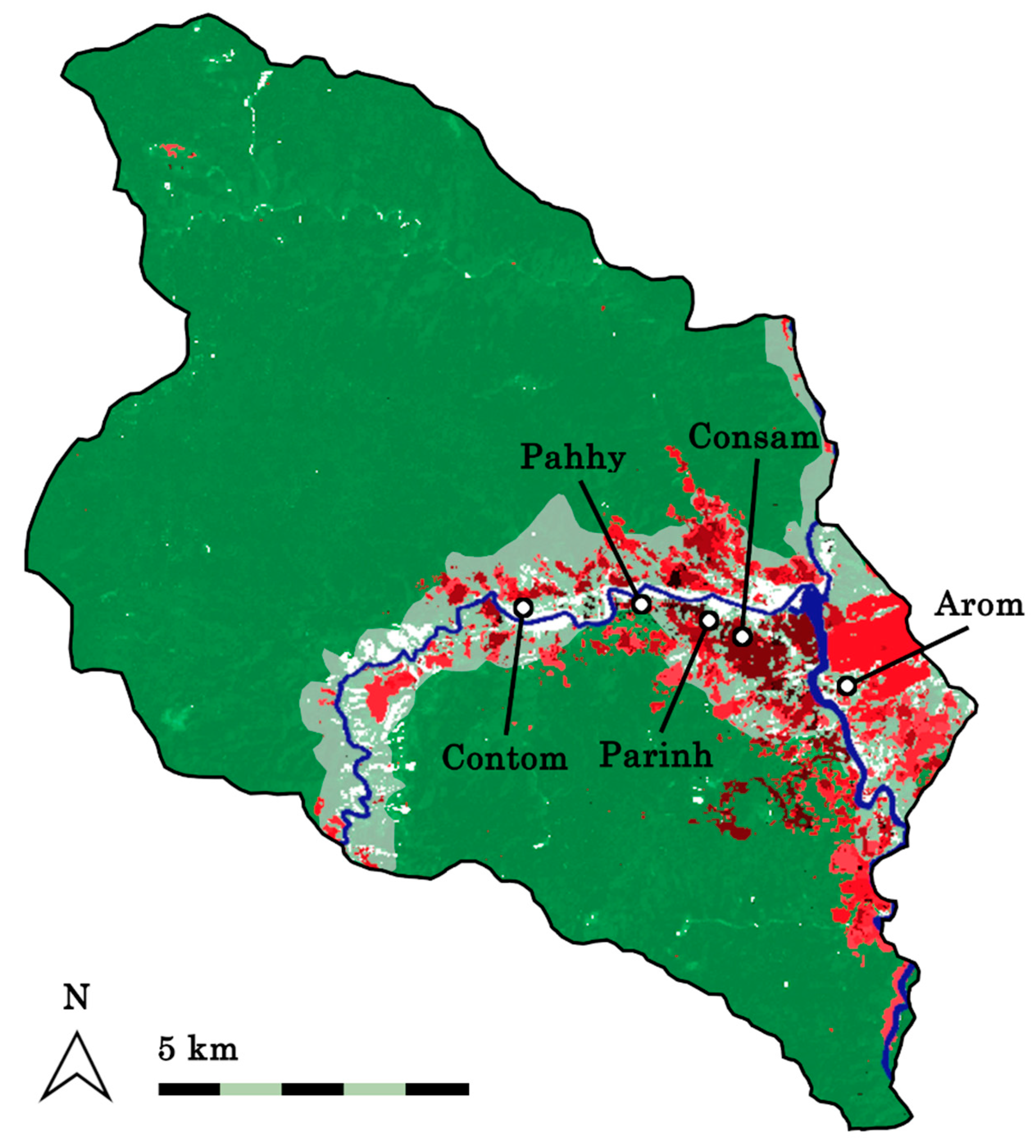
  82. Kobayashi, H.; Iizuka, A.; Shirasaka, R.; Kobayashi, M. A research on mountainous village in typhoon-flood prone area of Central Vietnam—A case study in Pa Ring village of Hong Ha commune, A Luoi district. J. Archit. Plann. 2008, 73, 2639–2645. [Google Scholar] [CrossRef] [Green Version]
  83. Iizuka, A. Traditional community houses of the Co-tu ethnic group in central Vietnam. SANSAI 2012, 97–114. [Google Scholar]
  84. Kobayashi, H.; Nguyen, T.N. Body-based units of measurement for building Katu community houses in Central Vietnam. In Vernacular Heritage and Earthen Architecture: Contributions for Sustainable Development; Correia, M., Carlos, G., Rocha, S., Eds.; Taylor & Francis Group: London, UK, 2014; pp. 359–364. ISBN 978-1-138-00083-4. [Google Scholar]
  85. Kobayashi, H.; Iizuka, A. Indigenous construction technology of Cotu Minorities in Central Vietnam. J. Archit. Plann. 2010, 75, 1679–1686. [Google Scholar] [CrossRef]
  86. Crowther, J.; Zimmer, H.; Le Thi, H.; Quang, T.L.; Nichols, J.D. Forestry in Vietnam: The potential role for native timber species. Forest Policy Econ. 2020, 116, 102182. [Google Scholar] [CrossRef]
  87. Carter, N.H.; Gurung, B.; Viña, A.; Campa, H., III; Karki, J.B.; Liu, J. Assessing spatiotemporal changes in tiger habitat across different land management regimes. Ecosphere 2013, 4, 1–19. [Google Scholar] [CrossRef]
Figure 1. Map of Thua Thien Hue Province showing Hong Ha Commune and the distribution of the province’s forest cover (in green [42]) and waterbodies (in blue [43]).
Sustainability 12 06232 g001
Figure 2. Structure of a coupled human and natural system (CHANS) with its components interacting at multiple organizational levels in two subsystems, drawn in resemblance to illustrations by Liu et al. [28]. Examples of components relevant to Vietnamese highland communes were added. All icons used are under public domain.
Sustainability 12 06232 g002
Figure 3. Non-linear change of crop yield by cropping year estimated by Le [33], if all other influencing factors such as labor input remain the same. Areas around lines indicate the standard error of model estimates by Le [33]. Dots indicate the mean crop yield (±standard error) at the mean cropping year (±standard error) estimated by Le [33] for hillside crop land (n = 134) and fruit tree land (n = 47), respectively. Lines were drawn to go through the reported means. Yields of other crops than rice were converted to the one of rice by Le [33].
Sustainability 12 06232 g003
Figure 4. Map of Hong Ha Commune showing the forest cover in 2000 (dark green) [42], the designated plantation area in 2007 (light green) [34], and the annual forest loss between 2000 and 2018 determined from satellite images (in red tones; a brighter tone indicates a later year) [42]. White dots indicate the centers of Hong Ha Commune’s five villages [47].
Sustainability 12 06232 g004
Figure 5. Cover of different types of forest in % of the total area of Hong Ha Commune (14,047 ha) published by Hoang and An [34].
Sustainability 12 06232 g005
Figure 6. Number of households and the average number of household members in Hong Ha Commune reported in past studies [31,32,33,44].
Sustainability 12 06232 g006
Table 1. Examples of complexity features of the socio-ecological dynamics in Hong Ha.
Complexity FeatureExamples
Reciprocal interactions and feedback loops
(Section 3.1)
(Positive feedback loop) Forest use → Forest degradation → Increased flood damage to agricultural land → Increased forest use;
(Negative feedback loop) Forest use → Forest degradation → Increased flood damage to agricultural land → Alternative income generation from tourism → Decreased forest use
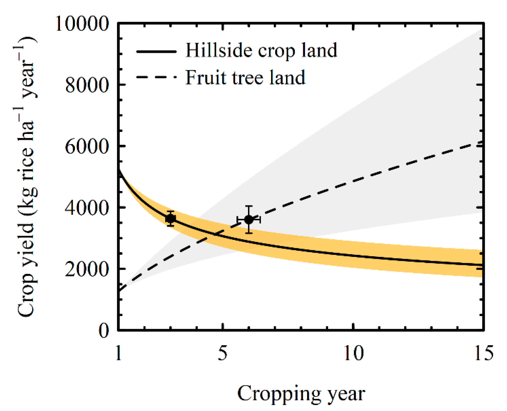
Non-linearity and thresholds
(Section 3.2)
(Non-linearity) Smaller response of crop yield with larger agrochemical input; Strong initial decrease in crop yield on hillside land; Long-term increase of crop yield on fruit tree land;
(Thresholds) Labor constraints prevent illegal forest use >2 km from settlement; Forest regeneration only within 20–30 m from natural forest edge
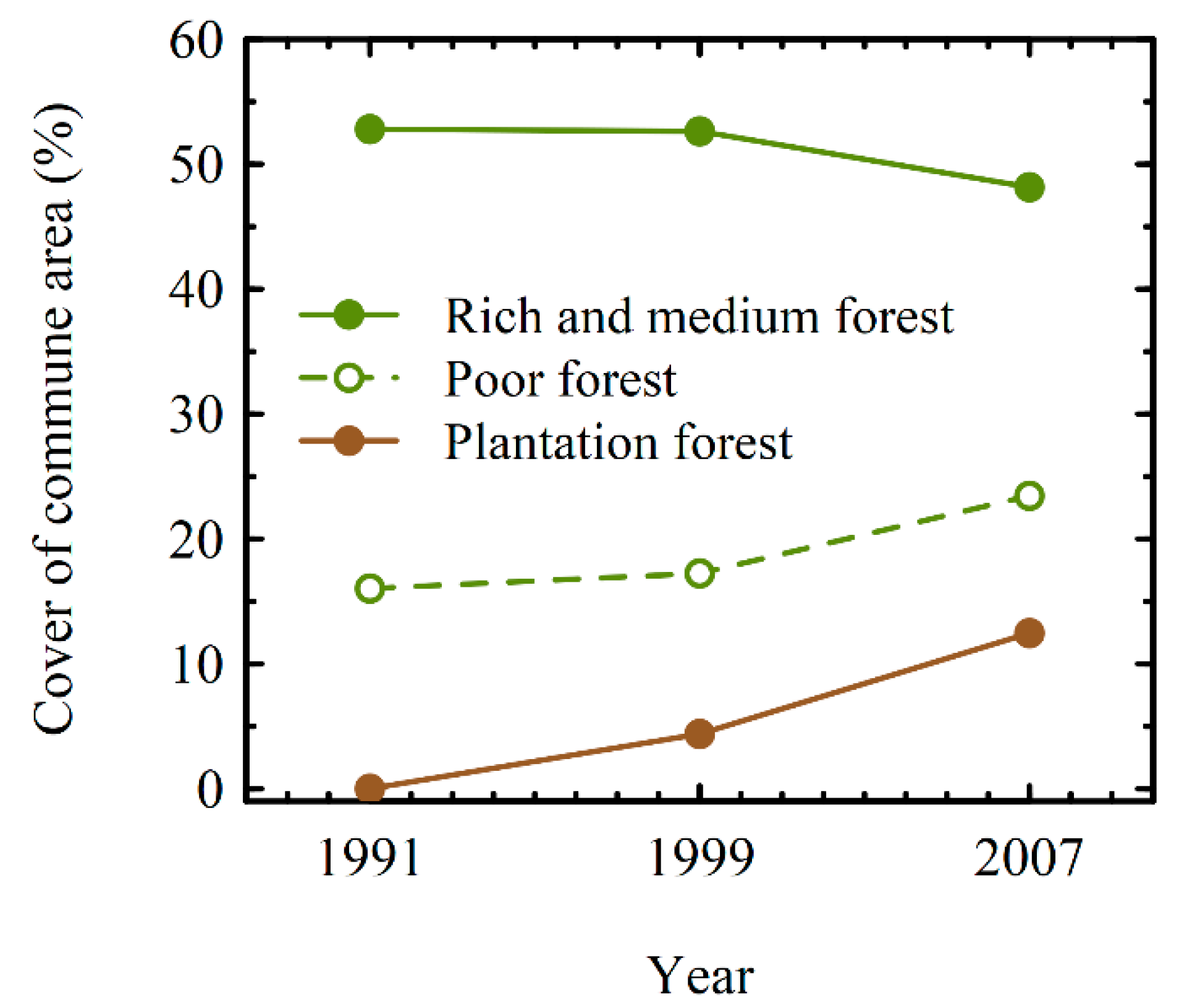
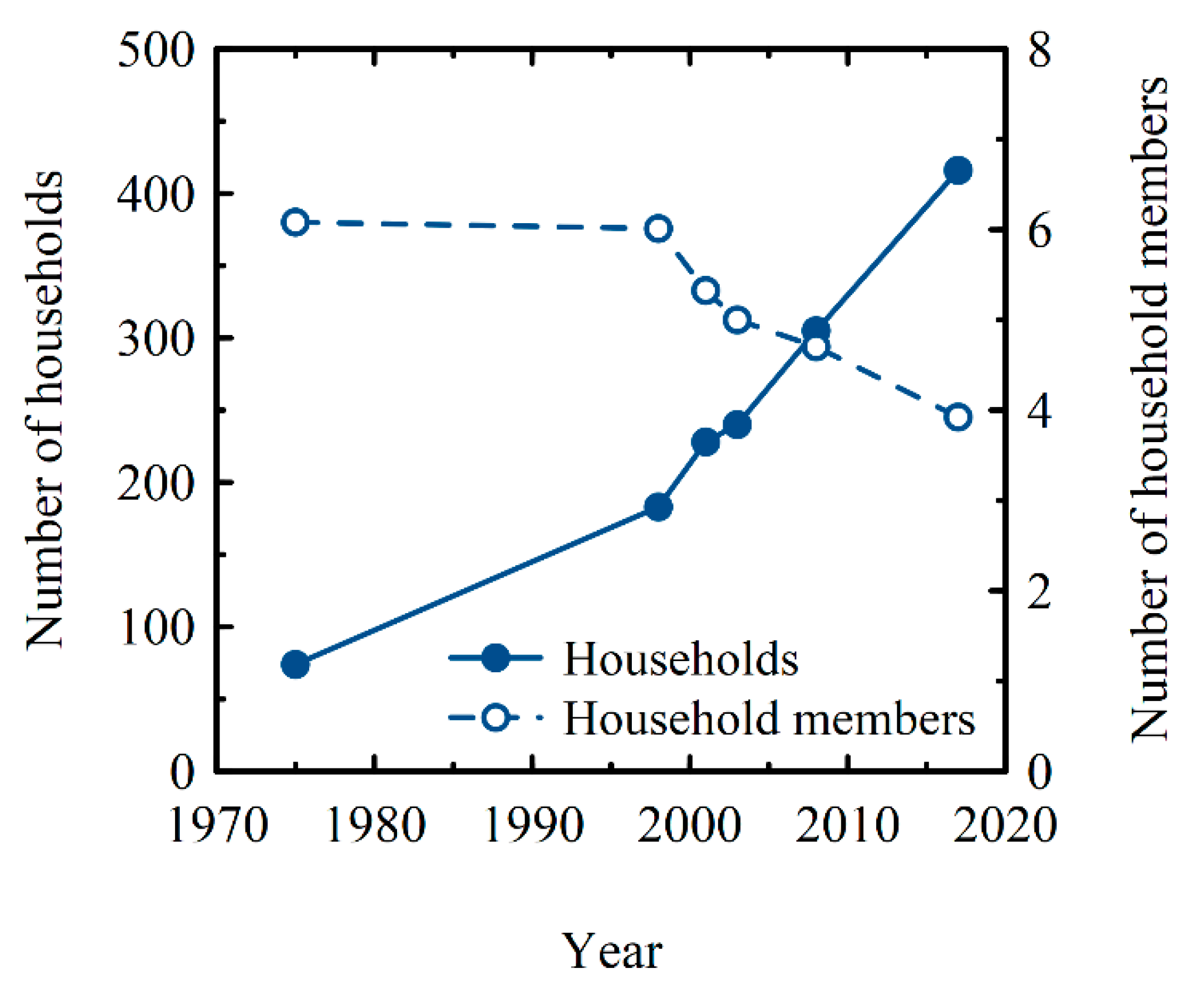
Surprises
(Section 3.3)
Decrease in forest quality after introducing strict forest protection policies;
Decrease in household size despite lower resource efficiency
Heterogeneity (Section 3.4)(Spatial) Crop yield variation by slope gradient; Impact of governmental development projects;
(Temporal) Shift of main income source from agriculture over Acacia cultivation to tourism;
(Across population) Service-related income of Kinh; Advantages of Kinh in Acacia sales
Telecoupling (Section 3.5)Coupling of highland water runoff to lowland floods; Influxes of income and visitors through ecotourism; Dependency on timber markets through Acacia cultivation
Vulnerability (Section 3.6)Vulnerabilities to flood damage, invasive Imperata grasses, diseases, and storms/typhoons
Time lags and legacy effects (Section 3.7)(Time lags) 15 years between suspending forest protection policy and increases in agricultural land/farm size; 20 years between change in forest protection policy and difference in income distribution; Seven years between Acacia planting and generation of income; (Legacy effects) Effects of Vietnam War and migration.

