Cycling as a Sustainable Transport Alternative in Polish Cittaslow Towns


Abstract
1. Introduction
- The research looks at the environmental needs (fewer sources of pollution, noise, a better energy mix), safety (reduction in cyclist accidents), pro-health aspects (better health and fitness of the population) and spatial and infrastructural needs (improved access to cycling infrastructure) of small towns.
- The research was carried out in small towns because infrastructure and safety analyses and data were not available for these sites, unlike Poland’s major cities and conurbations. Cittaslow towns were selected on purpose due to their unique character and programmes which give priority to the environment, reduction in emissions, improved energy mix, better safety and health standards of the population.
- The research units were selected specifically for not having or having hardly any cycling infrastructure or cycle paths (per km).
- There is a close relation between a lack of infrastructure or poor access to infrastructure and cycling as well as road safety in towns and especially outside them (e.g., for commuters).
- The research takes account of the importance of daily cycling by residents of small towns and making sure that the infrastructure meets those needs rather than just those of tourism, a seasonal phenomenon (being part of cycling trails). For this reason, the research does not include major tourist trails and their tourist infrastructure; instead, the work focuses on sections in and around small towns.
2. Literature Review
2.1. Policy of Green Cycling Infrastructure in the Context of Increasing Urban Cycling
2.2. The Importance of Cycling for Health
2.3. Road Safety in the Context of the Risk of Cyclist Accidents
2.4. The Importance of Building Cycling Infrastructure in Cittaslow Towns
2.5. Traffic Counts in Poland in Relation to the Legal Background
3. Materials and Methods
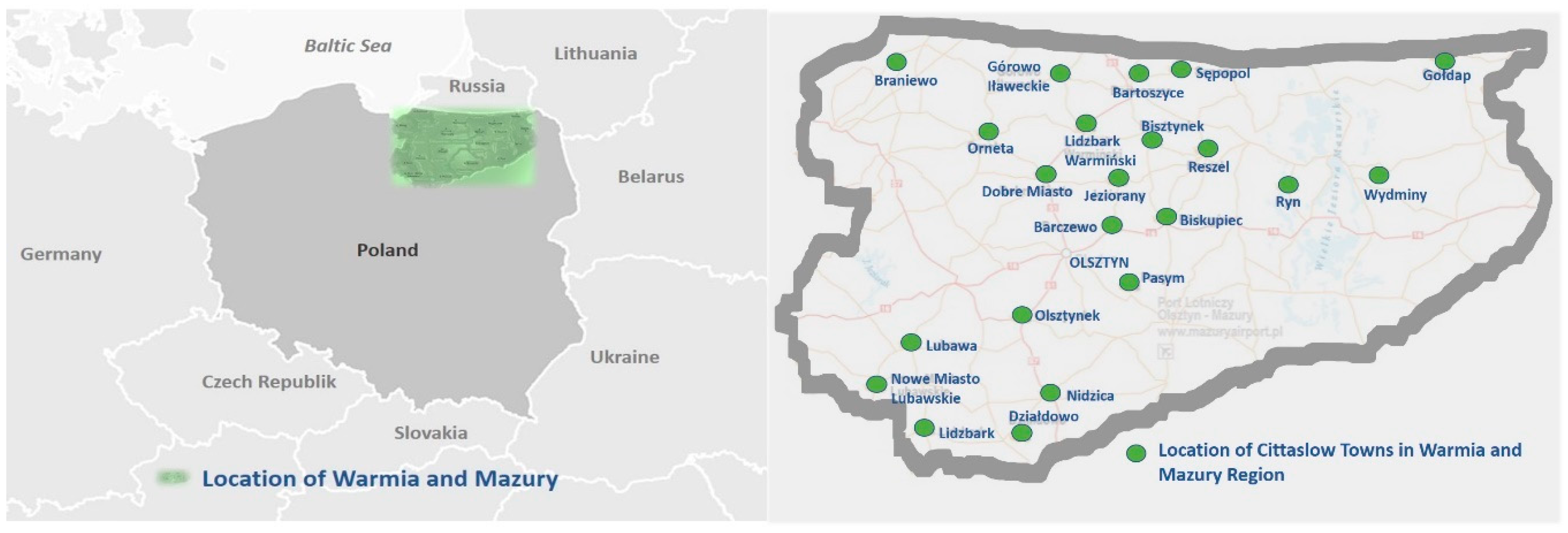
3.1. The Study Area
3.2. Methods of Cycle Counts in 2010 and 2015
- ADT—total average daily traffic of motor vehicles;
- MR—average daily traffic on workdays (from Monday to Friday, 6:00 a.m.–10:00 p.m.);
- 0.85MR—average daily traffic on Saturdays and days before public holidays (6:00 a.m.–10:00 p.m.);
- MN—average daily traffic on Sundays and public holidays (6:00 a.m.–10:00 p.m.);
- RN—average night traffic (10:00 p.m.–6:00 a.m.);
- N1—number of workdays in 2010 and 2015;
- N2—number of Saturdays and days before public holidays in 2010 and 2015;
- N3—number of Sundays and days before public holidays in the year;
- N—number of all days in the year.
- (1, 2, 4 measurements on workdays)(3, 6 measurements on Sundays and public holidays)
- measurement i at point j;
- Xij—number of total motor vehicles between 6:00 am–10:00 pm (measurement i at point j);
- Yij—number of total motor vehicles between 8:00 am–04:00 pm (measurement i at point j).
3.3. Analysis of Cyclist Accidents
3.4. Analysis of the Supra-Local Revitalisation Programme of Cittaslow Towns for Their Cycling Infrastructure
- the degree to which planned cycling infrastructure projects were changed in subsequent years;
- the scale of planned cycling infrastructure projects, including their location and length of cycle paths;
- priority given to cycling infrastructure projects over other projects;
- the degree of connectivity with existing infrastructure and its size in the town and outside it;
- availability of cycling infrastructure, especially in suburban areas;
- the goals of cycling infrastructure projects including social, environmental, health and transport goals.
4. Results and Discussion
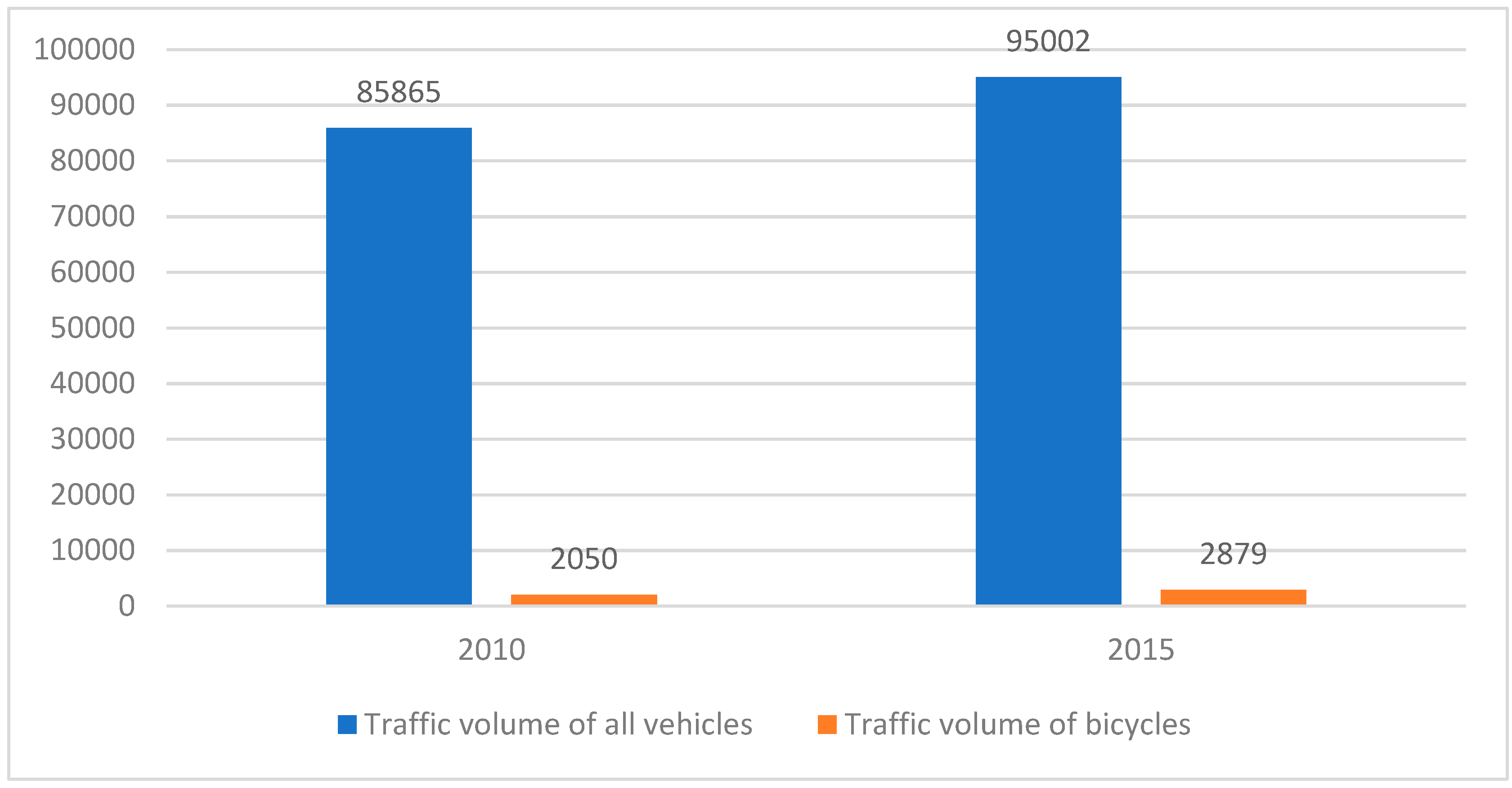
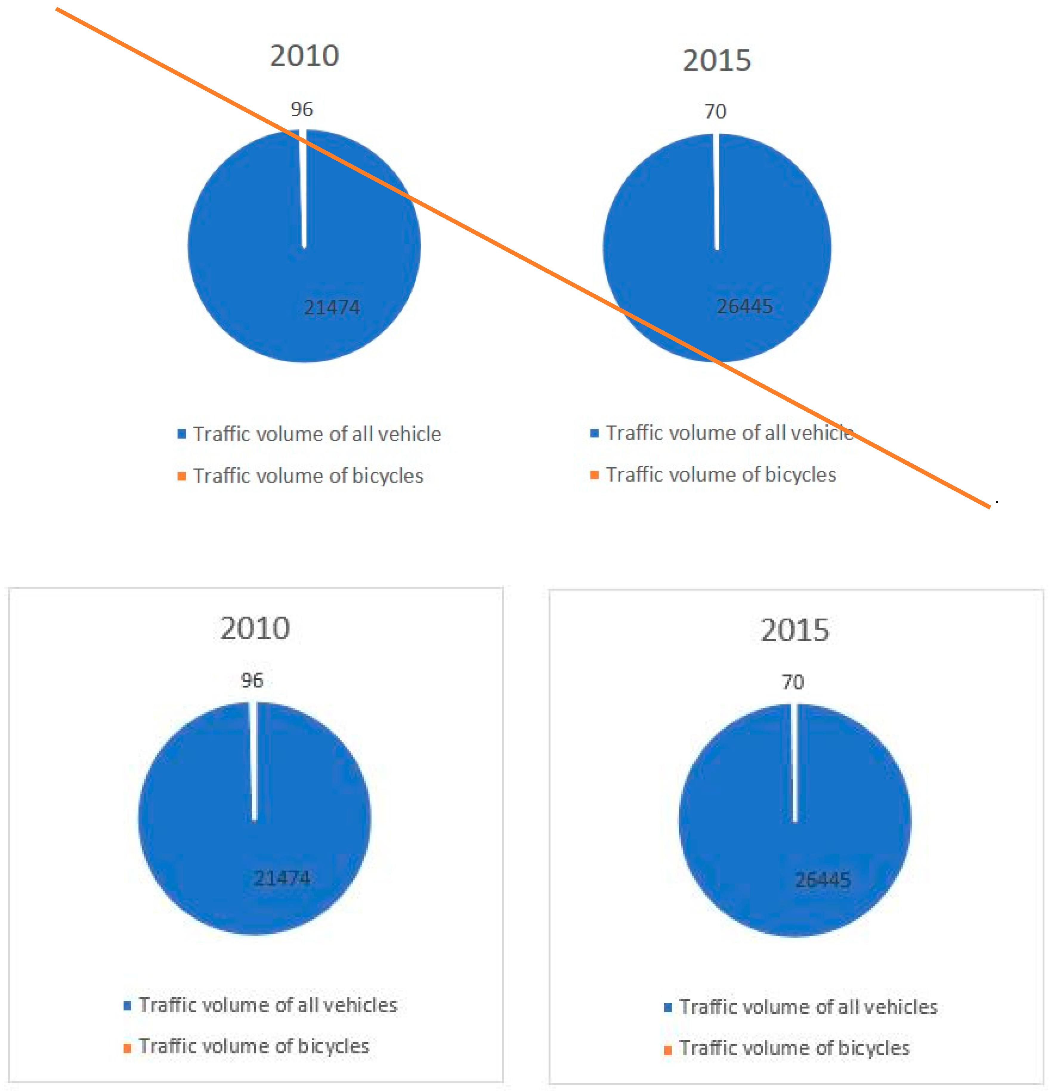
4.1. Results of Studies into the Number of Bicycles Used
4.2. Results of Studies into Cycle Path and Cycling Infrastructure Coverage
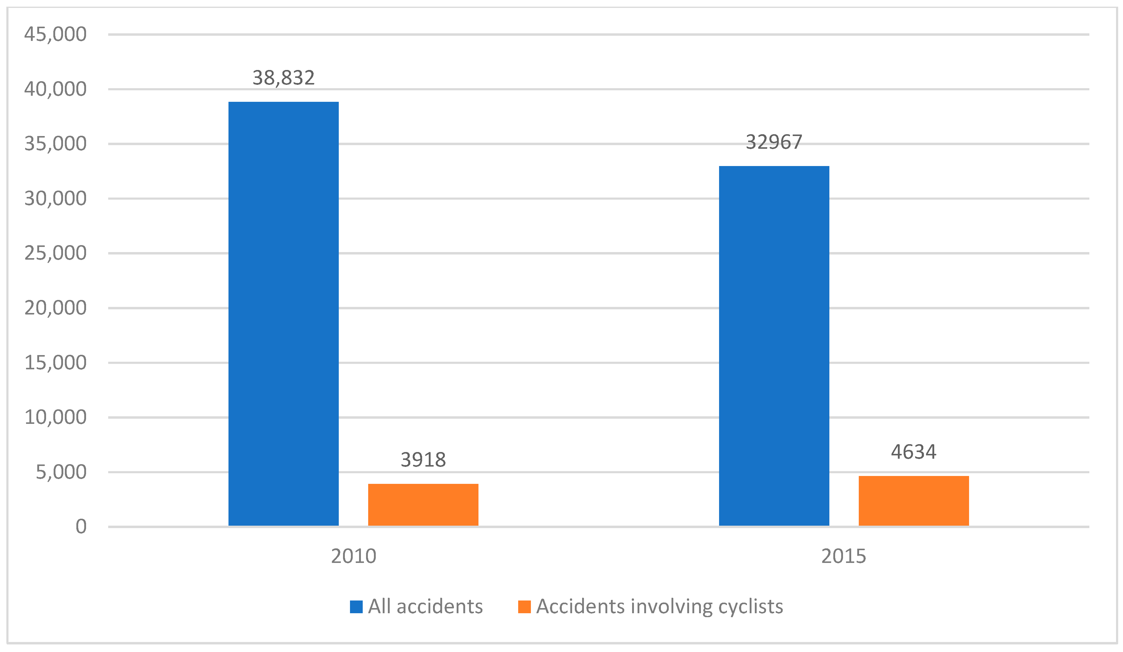
4.3. Analysis of Cyclist Accidents
4.4. Results of Analysis of the Supra-Local Revitalisation Programme of Cittaslow Towns for Its Cycling Infrastructure Planning (First Programme from 2015, Individual Programmes 2016–2017, Second Programme from 2019)
5. Guidelines and Recommendations for the Development of Cycling Infrastructure and for Road Safety
5.1. Specific Guidelines Based on the Research
5.1.1. Guidelines for Cycling Policy
- Cooperation between administrative bodies and road authorities and other bodies responsible for road infrastructure to develop guidelines for safe cycling infrastructure and cyclist safety on the road. Formulate local guidelines for road authorities, for example by consulting city authorities. Roads in Poland and in Warmia and Mazury are typically managed by a number of bodies which creates problems with planning. Having local guidelines for safe infrastructure and cyclist safety for each town would improve and accelerate the planning and construction of cycle paths as part of all roads.
- Develop cycling policy strategies for Cittaslow towns to take account of their unique character and demand for cycling infrastructure of people who commute between towns. The strategies should be based on a diagnosis of the individual towns and analysis of local conditions. As an example, the strategies of Braniewo, Bartoszyce and Gołdap and their suburban villages should be related to the towns’ close proximity to the state border with the Kaliningrad Region (Russia). This is because a cycle link must be ensured between these towns and the border crossing, the workplace for many commuters. On the other hand, this opens up new opportunities for tourism. The towns of Barczewo (and the areas outside it), Dobre Miasto and Olsztynek should focus their strategies on providing links to jobs and services in the regions’ biggest towns (with the distance as an important criterion).
- Develop and correlate other cycling infrastructure projects locally, regionally and nationally, making sure that there is a general cycle path strategy rather than isolated solutions (this is a common problem in Warmia and Mazury, especially in small towns, but the rest of Poland is no different); a comprehensive approach is needed to include existing sections and add new ones.
- Reinstate the original projects from the Supra-Local Revitalisation Programme of Cittaslow Towns of 2015 and generate new cycling infrastructure projects by including them in the new programme. Some of the priority actions would be to implement the city bike project in Gołdap, Lidzbark and Nowe Miasto Lubawskie and develop similar projects in the other towns. Furthermore, the pavement along the regional road in Dobre Miasto to be constructed in 2020 should be correlated with a new cycle path. It is important to plan pavements and cycle paths at the same time as opposed to planning pavements only.
5.1.2. Guidelines for Planning Infrastructure and Environmental Solutions
- Connect existing paths in the towns into a uniform transport system to include sections of national, regional, county, municipal and local roads. This requires the cooperation of the Regional Roads Authority and the General Directorate for National Roads and Motorways with town mayors to ensure a joint effort and cost-sharing when building new or upgrading existing cycling infrastructure. Decisions to link cycle paths should be based on local guidelines previously agreed to between road authorities and city authorities. Joint implementation and cost-sharing may be part of the guidelines.
- Plan and build new paths as dedicated roadside/street lanes (in and outside the town) and separate them from pavements or crossings as a separate lane (especially in towns). It is clear that densely developed parts of the towns under analysis cannot accommodate dedicated cycle paths. As a result, the proposal is to convert one of the pavements into a cycle path like this: convert the pavement on one side of the Łużycka street in Dobre Miasto and the Wojska Polskiego street in Nowe Miasto Lubawskie into a cycle path.
- Connect cycle paths in the town and extend them into rural areas. This should be a priority objective for all the towns under analysis.
- Plan for accompanying cycling infrastructure and path development through landscaping, especially where public spaces are concerned such as parks, squares, plazas e.g., in Biskupiec, Dobre Miasto, Lidzbark Warmiński, Gołdap, Bartoszyce.
5.1.3. Guidelines for Improving Safety and Accident Statistics
- Conduct detailed cycle traffic counts as separate from the General Traffic Count. Cycle traffic counts should be conducted at least twice a year—at the beginning and end of the cycling season; traffic should be studied off-season to understand whether cycling is a seasonal or year-round activity.
- Monitor, analyse and improve road infrastructure in high risk sites for cycling. Analyse cyclist accident databases, put up CCTV in accident sites and analyse the data collected to identify the cause and develop solutions.
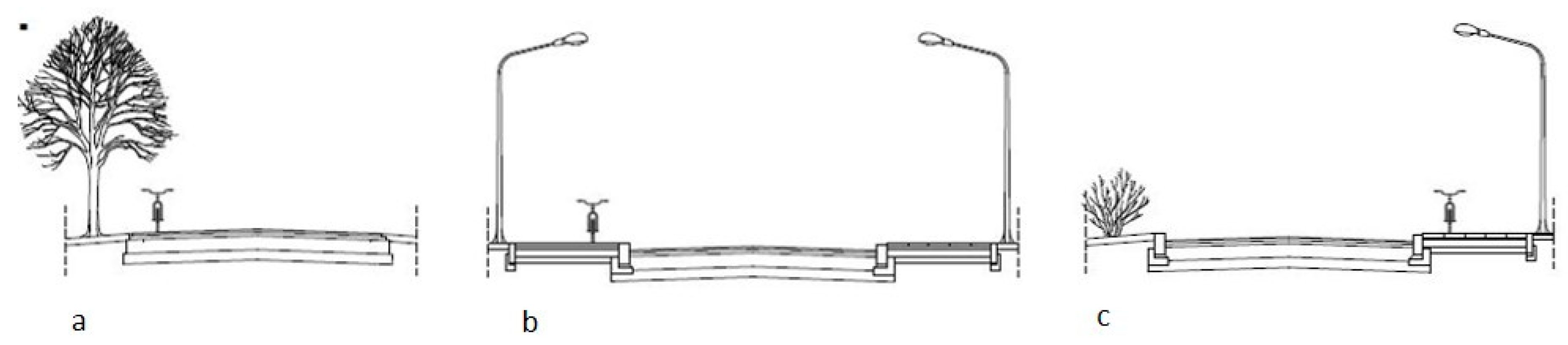
- Separate cycle paths clearly from other road users (especially from cars and pedestrians), primarily in towns and outside of them. Apply physical barriers between cycle traffic and motor traffic such as greenery or road barriers, separate pedestrians from cyclists by raising pavements in relation to cycle paths or by separating the two surfaces.
5.2. General Recommendations
- Conduct an analysis of good practice from Cittaslow towns worldwide which have successfully implemented and are running cycling infrastructure and safety projects. This solution can be easily taken up in the form of joint initiatives between Polish Cittaslow towns and transport and planning (which includes cycle path development) specialists from Cittaslow towns in, for example, the Netherlands, Germany, the Nordic Cittaslow Network.
- Correlate educational programmes on safety with the educational activities of schools, police, municipal guards, public administration and all entities involved in transport, road traffic and health.
- Joint activities to promote cycling as a means of transport for all Cittaslow towns using thematic meetings and events for the communities. Promote active leisure for families with the bicycle as a means of transport.
- Create a system to enable the free transport of bicycles by other means of transport over longer distances. This includes rail transport to carry bicycles free of charge from Braniewo, Nidzica, Olsztynek, Pasym, Barczewo to Olsztyn, the region’s biggest town. It also includes a proposal to allow people to cycle from the town or village to a train station and then continue the trip by train (a solution commonly used in the countries of Western Europe, not so much in Poland).
- Prepare specimens of materials for paths and path surfaces to follow the local character and environmental requirements (e.g., paved or bituminous paths). Keep all types and colours of surfaces the same in Cittaslow towns, ensuring a more intuitive cycling.
- Identify ways to use the potential of the environment in ensuring that cycling routes pass through attractive countryside.
- Plan for green areas which are best run along paths with trees, shrubs and low growth. Using low growth in dedicated sections in Bartoszyce and Lidzbark Warmiński to physically separate bicycles from cars would replace road barriers which are not as aesthetic. A similar solution has already been applied in Działdowo.
- Use distinct horizontal marking for cyclist crossings on main roads (preferably red marking), primarily in non-built-up areas. Horizontal marking of the same colour as the cycle path (preferably red) every time the path crosses the road.
- Use additional vertical marking in places where cyclists cross the road (including fluorescent marking) to warn other road users.
- Where cyclist crossings cross minor roads, keep cyclist crossings away from the main road and run them perpendicularly to the minor road, “deflecting” the cycling route before the cycle crossing.
- Use elements of traffic calming, especially in the town centre and areas of heavy motor traffic. To get motorists to slow, use raised cycle crossings and narrower cross-sections by designating cycle paths that are made distinct from the road by separators and colour (red).
- Use contraflow lanes physically separated from the road as separate cycle lanes to allow cyclists to ride “against the flow” in towns in specific areas.
6. Conclusions
Author Contributions
Funding
Conflicts of Interest
References
- Kristianova, K. Public space connectivity and walkability in suburban neighborhoods—Case studies from Nitra and Košice, Slovakia. In Proceedings of the International Multidisciplinary Scientific GeoConference: SGEM: Surveying Geology & Mining Ecology Management, Albena, Bulgaria, 28 June–6 July 2016; pp. 675–682. [Google Scholar] [CrossRef]
- Kwiatkowski, A. Urban Cycling as an Indicator of Socio-Economic Innovation and Sustainable Transport. Quaest. Geogr. 2018, 37, 23–32. [Google Scholar] [CrossRef]
- McLeod, S.; Scheurer, J.; Curtis, C. Urban Public Transport: Planning Principles and Emerging Practice. J. Plan. Lit. 2017, 32, 223–239. [Google Scholar] [CrossRef]
- Kazak, J.; Chalfen, M.; Kamińska, J.; Szewrański, S.; Świąder, M. Geo-Dynamic Decision Support System for Urban Traffic Management. In Dynamics in GIscience, Proceedings of GIS Ostrava, Ostrava, Czech Republik, 21–23 March 2018; Lecture Notes in Geoinformation and Cartography; Ivan, I., Horák, J., Inspektor, T., Eds.; Springer: Cham, Switzerland, 2018. [Google Scholar]
- Kazak, J.; Garcia Castro, D.; Swiader, M.; Szewranski, S.Z. Decision Support System in Public Transport Planning for Promoting Urban Adaptation to Climate Change. IOP Conf. Ser. Mater. Sci. Eng. 2019, 471. [Google Scholar] [CrossRef]
- Fraser, S.D.S.; Lock, K. Cycling for transport and public health: A systematic review of the effect of the environment on cycling. Eur. J. Public Health 2011, 21, 738–743. [Google Scholar] [CrossRef] [PubMed]
- Aletta, F.; Van Renterghem, T.; Botteldooren, D. Influence of Personal Factors on Sound Perception and Overall Experience in Urban Green Areas. A Case Study of a Cycling Path Highly Exposed to Road Traffic Noise. Int. J. Environ. Res. Public Health 2018, 15, 1118. [Google Scholar] [CrossRef] [PubMed]
- Hull, A.; O’Holleran, C. Bicycle infrastructure: Can good design encourage cycling? Urban Plan. Transp. Res. 2014, 2, 369–406. [Google Scholar] [CrossRef]
- Sarjala, S. Built environment determinants of pedestrians’ and bicyclists’ route choices on commute trips: Applying a new grid-based method for measuring the built environment along the route. J. Transp. Geogr. 2019, 78, 56–69. [Google Scholar] [CrossRef]
- Fishman, E. Cycling as transport. Transp. Rev. 2016, 36, 18. [Google Scholar] [CrossRef]
- Li, H. Study on Green Transportation System of International Metropolises. Procedia Eng. 2016, 137, 762–771. [Google Scholar] [CrossRef]
- Buehler, R.; Pucher, J.; Gerike, R.; Götschi, T. Reducing car dependence in the heart of Europe: Lessons from Germany, Austria, and Switzerland. Transp. Rev. 2017, 37, 4–28. [Google Scholar] [CrossRef]
- Frondela, M.; Vance, C. Cycling on the extensive and intensive margin: The role of paths and prices. Transp. Res. Part A Policy Pract. 2017, 104, 21–31. [Google Scholar] [CrossRef]
- Silva, C.; Teixeira, J.; Proenca, A.; Bicalho, T.; Cunha, I.; Aguiar, A. Revealing the cycling potential of starter cycling cities: Usefulness for planning practice. Transp. Policy 2019, 81, 38–147. [Google Scholar] [CrossRef]
- OECD/ITF. Transition to Shared Mobility—How Large Cities Can Deliver Inclusive Transport Services; Raport of the International Transport Forum: Paris, France, 2017; pp. 1–54. Available online: www.itf-oecd.org (accessed on 5 May 2020).
- Kristianova, K.; Marcinkova, D. Cestné komunikácie ako verejný priestor a cestná zeleň. In Perspektivy Území III: Veřejné Prostory a Prostranství; ČVUT: Prague, Czech Republic, 2015; pp. 50–55. Available online: http://adminu.lhosting4.cz/Include/Data/getfile.php?id=1756&db=uzemieu (accessed on 10 May 2020).
- Cervero, R.; Duncan, M. Walking, Bicycling, and Urban Landscapes: Evidence from the San Francisco Bay Area. Am. J. Public Health 2003, 93, 1478–1483. [Google Scholar] [CrossRef] [PubMed]
- Sturiale, L.; Scuderi, A. The Evaluation of Green Investments in Urban Areas: A Proposal of an eco-social-green Model of the City. Sustainability 2018, 10, 4541. [Google Scholar] [CrossRef]
- Cervero, R.; Denman, S.; Jin, Y. Network design, built and natural environments and bicycle commuting: Evidence from British cities and towns. Transp. Policy 2019, 74, 153–164. [Google Scholar] [CrossRef]
- Campos-Sánchez, F.S.; Valenzuela-Montes, L.M.; Abarca-Álvarez, F.J. Evidence of Green Areas, Cycle Infrastructure and Attractive Destinations Working together in Development on Urban Cycling. Sustainability 2019, 11, 4730. [Google Scholar] [CrossRef]
- Fernández-Heredia, A.; Monzón, A.; Jara-Díaz, S. Understanding cyclists’ perceptions, keys for a successful bicycle promotion. Transp. Res. Part A Policy Pract. 2014, 63, 1–11. [Google Scholar] [CrossRef]
- Ogilvie, D.; Egan, M.; Hamilton, V.; Petticrew, M. Promoting walking and cycling as an alternative to using cars: A systematic review. BMJ 2004, 329, 763–776. [Google Scholar] [CrossRef]
- Cohen, B.; Kietzmann, J. Ride On! Mobility Business Models for the Sharing Economy. Organ. Environ. 2014, 27, 279–296. [Google Scholar] [CrossRef]
- Drużyńska, P.; Knysak, J.; Świąder, M.; Kazak, J. Assessment of the Effectiveness of the Wrocław City Bike. Acta Sci. Pol. Adm. Locorum 2016, 15, 33–45. [Google Scholar]
- Scotini, R.; Skinner, I.; Racioppi, F.; Fusé, V.; Bertucci, J.D.O.; Tsutsumi, R. Supporting Active Mobility and Green Jobs through the Promotion of Cycling. Int. J. Environ. Res. Public Health 2017, 14, 1603. [Google Scholar] [CrossRef] [PubMed]
- Meenar, M.; Flamm, B.; Keenan, K. Mapping the Emotional Experience of Travel to Understand Cycle-Transit User Behavior. Sustainability 2019, 11, 4743. [Google Scholar] [CrossRef]
- Dill, J. Bicycling for Transportation and Health: The Role of Infrastructure. J. Public Health Policy 2009, 30, 95–110. [Google Scholar] [CrossRef] [PubMed]
- Maas, J.; Verheij, R.A.; Spreeuwenberg, P. Physical activity as a possible mechanism behind the relationship between green space and health: A multilevel analysis. BMC Public Health 2008, 8, 206. [Google Scholar] [CrossRef]
- Li, A.; Huanga, Y.; Axhausen, K.W. An approach to imputing destination activities for inclusion in measures of bicycle accessibility. J. Transp. Geogr. 2020, 82, 102566. [Google Scholar] [CrossRef]
- Oja, P.; Titze, S.; Bauman, A.; De Geus, B.; Krenn, P.; Reger-Nash, B.; Kohlberger, T. Health benefits of cycling: A systematic review. Scand. J. Med. Sci. Sports 2011, 21, 496–509. [Google Scholar] [CrossRef] [PubMed]
- Lee, I.-M.; Shiroma, E.J.; Lobelo, F.; Puska, P.; Blair, S.N.; Katzmarzyk, P.T. Effect of physical inactivity on major non-communicable diseases worldwide: An analysis of burden of diseases and life expectancy. Lancet 2012, 380, 219–229. [Google Scholar] [CrossRef]
- Bauman, A.E.; Reis, R.S.; Sallis, J.F.; Wells, J.C.; Loos, R.J.; Martin, B.W. Correlates of physical activity: Why are some people physically active and others not? Lancet 2012, 380, 258–271. [Google Scholar] [CrossRef]
- Götschi, T.; Garrard, J.; Giles-Corti, B. Cycling as a Part of Daily Life: A Review of Health Perspectives. Transp. Rev. 2016, 36, 45–71. [Google Scholar] [CrossRef]
- Pucher, J.; Dijkstra, L. Promoting Safe Walking and Cycling to Improve Public Health: Lessons from the Netherlands and Germany. Am. J. Public Health 2003, 93, 1509–1516. [Google Scholar] [CrossRef]
- Lakerveld, J.; Woods, C.; Hebestreit, A.; Brenner, H.; Flechtner-Mors, M.; Harrington, J.M.; Kamphuis, C.B.M.; Laxyi, M.; Luszczynska, A.; Mazzocchi, M.; et al. Advancing the evidence base for public policies impacting on dietary behaviour, physical activity and sedentary behaviour in Europe: The Policy Evaluation Network promoting a multidisciplinary approach. Food Policy 2020. [Google Scholar] [CrossRef]
- Gutierrez, M.; Cantillo, V.; Arellana, J.; Ortúzar, J. Estimating bicycle demand in an aggressive environment. Int. J. Sustain. Transp. 2020, 1–14. [Google Scholar] [CrossRef]
- Ortúzar, J. Sustainable Urban Mobility: What Can Be Done to Achieve It? J. Indian Inst. Sci. 2019, 99, 683–693. [Google Scholar] [CrossRef]
- Fallon Mayers, R.; Glover, T.D. Whose Lane Is It Anyway? The Experience of Cycling in a Mid-Sized City. Leis. Sci. 2019. [Google Scholar] [CrossRef]
- Reynolds, C.C.; Harris, M.A.; Teschke, K.; Cripton, P.A.; Winters, M. The impact of transportation infrastructure on bicycling injuries and crashes: A review of the literature. Environ. Health 2009, 8, 47. [Google Scholar] [CrossRef]
- Lawson, A.R.; Ghosh, B.; Pakrashi, V. Quantifying the perceived safety of cyclists in Dublin. Proc. Inst. Civ. Eng. Transp. 2015, 168, 290–299. [Google Scholar] [CrossRef][Green Version]
- Aldred, R.; Jungnickel, K. Why culture matters for transport policy: The case of cycling in the UK. J. Transp. Geogr. 2014, 34, 78–87. [Google Scholar] [CrossRef]
- Helbich, M.; Böcker, L.; Dijst, M. Geographic heterogeneity in cycling under various weather conditions: Evidence from Greater Rotterdam. J. Transp. Geogr. 2014, 38, 38–47. [Google Scholar] [CrossRef]
- Nosal, T.; Miranda-Moreno, L.F. The effect of weather on the use of North American bicycle facilities: A multi-city analysis using automatic counts. Transp. Res. Part A Policy Pract. 2014, 66, 213–225. [Google Scholar] [CrossRef]
- Kachaniak, D.; Reducha, M.; Skrzyńska, J. Raport z Badania na Temat Uwarunkowań do Podejmowania Transportowej Aktywności Fizycznej Polaków; TNS POLSKA dla Ministerstwa Sportu i Turystyki Rzeczpospolitej Polskiej: Warszawa, Poland, 2015; p. 36. Available online: https://www.msit.gov.pl/pl/sport/badania-i-analizy/aktywnosc-fizyczna-spol/575 (accessed on 10 May 2020).
- Bíla, M.; Bílová, M.; Müller, I. Critical factors in fatal collisions of adult cyclists with automobiles. Accid. Anal. Prev. 2010, 42, 1632–1636. [Google Scholar] [CrossRef]
- Zawadzka, A.K. Making Small Towns Visible in Europe: The Case of Cittaslow Network—The Strategy Based on Sustainable Development. Transylv. Rev. Adm. Sci. 2017, 90–106. [Google Scholar] [CrossRef]
- Jaszczak, A. The Future of Cittaslow Towns. Archit. Kraj. 2015, 1, 70–81. [Google Scholar]
- Wierzbicka, W.; Farelnik, E.; Stanowicka, A. The Development of the Polish National Cittaslow Network. Olszt. Econ. J. 2019, 14, 113–125. [Google Scholar] [CrossRef]
- Farelnik, E.; Stanowicka, A. Smart city, slow city and smart slow city as development models of modern cities. Olszt. Econ. J. 2016, 11. [Google Scholar] [CrossRef]
- Jaszczak, A.; Kristianova, K. Social and Cultural Role of Greenery in Development of Cittaslow Towns. IOP Conf. Ser. Mater. Sci. Eng. 2019, 603, 032028. [Google Scholar] [CrossRef]
- Ustawa z Dnia 21 Marca 1985 r. o Drogach Publicznych (Dz. U. 2020 poz. 470). Available online: http://prawo.sejm.gov.pl/isap.nsf/DocDetails.xsp?id=wdu19850140060 (accessed on 10 April 2020).
- Available online: www.gddkia.gov.pl (accessed on 15 April 2020).
- ZDW Olsztyn. Available online: http://www.zdw.olsztyn.pl/strona-glowna/aktualnosci.html?start=64 (accessed on 15 April 2020).
- Opoczyński, K. Wytyczne Pomiaru Ruchu na Drogach Wojewódzkich w 2010 Roku; Generalna Dyrekecja Dróg i Autostrad: Warszawa, Poland, 2009. Available online: https://www.gddkia.gov.pl/userfiles/articles/g/GENERALNY_POMIAR_RUCHU_2010/0.1.1.2_Wytyczne_DW_GPR_2010.pdf (accessed on 15 March 2020).
- Kowalski, K.; Kaplar, I.; Maśkiewicz, J.; Dobrzyński, Ł.; Wojdyński, R. Wytyczne Generalnego Pomiaru Ruchu w 2015 na Drogach Wojewódzkich; Generalna Dyrekcja Dróg Krajowych i Autostrad: Warszawa, Poland, 2014. Available online: https://www.gddkia.gov.pl/userfiles/articles/g/generalny-pomiar-ruchu-w-2015_15598/Wytyczne%20GPR%20na%20dr%20woj%20w%202015%20r_zakceptowane_ok.pdf (accessed on 15 March 2020).
- Opoczyński, K. Wytyczne Organizacji i Przeprowadzenia Generalnego Pomiaru Ruchu w 2010 na Drogach Krajowych; Załącznik do Zarządzenia nr 59 z Dnia 12.10.2009; Generalna Dyrekcja Dróg Krajowych i Autostrad: Warszawa, Poland, 2009. Available online: https://www.gddkia.gov.pl/userfiles/articles/g/GENERALNY_POMIAR_RUCHU_2010/0.1.1.1_Wytyczne_GPR_2010.pdf (accessed on 15 March 2020).
- Kowalski, K.; Kaplar, I.; Maśkiewicz, J.; Dobrzyński, Ł.; Wojdyński, R. Metoda Przeprowadzenia Generalnego Pomiaru Ruchu w Roku 2015; Generalna Dyrekecja Dróg i Autostrad: Warszawa, Poland, 2014. Available online: https://www.gddkia.gov.pl/userfiles/articles/z/zarzadzenia-generalnego-dyrektor_13901/zarzadzenie%2038%20Zalacznik_b_Metoda%20GPR%202015.pdf (accessed on 15 March 2020).
- Regional Operational Programme of the Voivodeship of Warmia and Mazury 2014-2020. Available online: https://ec.europa.eu/growth/tools-databases/regional-innovation-monitor/policy-document/regional-operational-programme-voivodeship-warmia-and-mazury-2014-2020 (accessed on 15 April 2020).
- Ponadlokalny Programu Rewitalizacji Miast Cittaslow. 2015. Available online: https://www.wmarr.olsztyn.pl/s/images/stories/Pliki/2015_06_08_Ponadlokalny_program_rewitalizacji_sieci_miast_Cittaslow.pdf (accessed on 10 February 2020).
- Ponadlokalny Program Rewitalizacji Miast Cittaslow. 2019. Available online: https://cittaslowpolska.pl/images/PDF/PPR_08_2019.pdf (accessed on 10 February 2020).
- Raport “Transportowe Zwyczaje Polaków” dla Busradar.pl, January 2019. Available online: www.transport-publiczny.pl (accessed on 10 March 2020).
- Bank Danych Lokalnych Głównego Urzędu Statystycznego. Available online: www.bdl.stat.gov.pl (accessed on 18 May 2020).
- Łysoń, P.; Barlik, M.; Lewandowska, B.; Siwiak, K. Zeszyt Metodologiczny; Badanie Budżetów Gospodarstw Domowych; Główny Urząd Statystyczny, Departament Badań Społecznych: Warszawa, Poland, 2018. Available online: https://stat.gov.pl/download/gfx/portalinformacyjny/pl/defaultaktualnosci/5486/10/2/1/zeszyt_metodologiczny_badanie_budzetow_gospodarstw_domowych.pdf (accessed on 15 April 2020).
- GDDKiA Olsztyn. Available online: www.gddkia.gov.pl (accessed on 15 April 2020).
- Symon, E. Wypadki Drogowe w Polsce w 2010r; Zespół Profilaktyki i Analiz Biura Ruchu Drogowego Komendy Głównej Policji: Warszawa, Poland, 2011; Available online: http://statystyka.policja.pl/st/ruch-drogowy/76562,wypadki-drogowe-raporty-roczne.html (accessed on 10 March 2020).
- Symon, E. Wypadki Drogowe w Polsce w 2015r; Wydział Opiniodawczo-Analityczny Biura Ruchu Drogowego Komendy Głównej Policji: Warszawa, Poland, 2016; Available online: http://statystyka.policja.pl/st/ruch-drogowy/76562,wypadki-drogowe-raporty-roczne.html (accessed on 10 March 2020).


| Sections in Built-Up Areas | Sections Beyond the | ||
|---|---|---|---|
| Town | Street | Town | Road Section |
| Braniewo | Elbląska | Bisztynek | Bartoszyce-Bisztynek |
| Biskupiec | Kościuszki | Barczewo | Olsztyn-Barczewo |
| Bartoszyce | Kętrzyńska | Górowo Iławeckie | Górowo Iławeckie-Bartoszyce |
| Dobre Miasto | Łużycka | Jeziorany | Dobre Miasto-Jeziorany |
| Działdowo | Olsztyńska | Olsztynek | Olsztynek-Zgniłocha |
| Gołdap | Paderewskiego | Pasym | Olsztyn-Pasym |
| Lidzbark Warmiński | Olsztyńska | Ryn | Sterławki Wielkie-Ryn |
| Lidzbark | Piaski | Wydminy | Kąp-Wydminy |
| Lubawa | 19 Stycznia | ||
| Nidzica | 1-go Maja | ||
| Nowe Miasto Lubawskie | Wojska Polskiego | ||
| Orneta | 1-go Maja | ||
| Reszel | Słowiańska | ||
| Town | Title of Comprehensive Project (PK), Sub-Measure (P) and Location (L) |
|---|---|
| Barczewo | PK: Develop the Old Town’s public space P1: Prepare cycling and walking routes P2: Plan leisure infrastructure in the centre of the Old Town, prepare a cycling and walking route L: Old Town |
| Biskupiec | PK: Regeneration of deprived spaces P1: Build cycle roads L1: Link the existing cycle path at Warszawska street with the second existing path around Kraks Mały lake. L2: Floriańska, Topiel, Syreny, Warmińska, Poznańska, Polna, Bohaterów streets. L3: Along Hubalczyków street across the post-military area. L4: Link the existing cycle path in the part at Wiosenna street with the route around the adjacent retention pond |
| Bisztynek | PK: Improve population mobility by adding functional and aesthetic features into public space P1: Build a cycling and educational trail P2: Make avenues and streets people-friendly by building cycle roads—improve the mobility of the Bisztynek population, using an environmentally friendly form of transport L: the streets of Kąpielowa, Słoneczna, Obwodowa, Struga, Kajki, Wiktora, Moniuszki, Konopnickiej, Grunwaldzkiej, Szkolna, Polna, Pl. Wolności, Słoneczna, Nowego Osiedla, Orzeszkowej and Sportowa |
| Dobre Miasto | PK: Regenerate deprived public spaces P: Modernise, upgrade and build pedestrian and car shared zones and pedestrian and cyclist shared zones to ensure safety L: Sites along the river Łyna |
| Gołdap | PK: No main project in the revitalisation programme to address cycling infrastructure, additional projects to build a well-lit cycle path and implementation of the city bike project L: From the city centre to the health resort district |
| Górowo Iławeckie | PK: Improve the site by creating a leisure and sensory park P1: Build a path for pedestrians and cyclists L: Park at Staw Garncarski pond PK: Improve the area in the valley of the river Młynówka—project on reserve list P: Build a walking and cycling path and link the site to Eastern Poland Cycling Routes and other sites in the town L: City Lagoon, valley of the river Młynówka |
| Lidzbark Warmiński | PK: No main project in the revitalisation programme to address cycling infrastructure |
| Lubawa: | PK: Revitalisation of selected sites to meet the need for exercise therapy for socially excluded people P: Build a walking and cycling path Zalew—Lipy L: Kopernika street across parts of Lipowa street and Pielgrzyma street to Kupnera street |
| Nidzica | PK: No main project in the revitalisation programme to address cycling infrastructure |
| Nowe Miasto Lubawskie | PK: Integration and engagement of socially excluded people in the revitalised area through recreation and physical activity P: Build a cycle road on the railway embankment in place of the disused Brodnica—Iława train line and implement the city bike project L: City Park, site in the post-railway area |
| Olsztynek | PK: Build a health path “Healthy body, healthy spirit” P: Build a health path and implement the city bike project L: Urban and sub-urban areas |
| Pasym | PK: No main project in the revitalisation programme to address cycling infrastructure |
| Reszel | PK: Restore the natural, architectural and functional features of City Park. P: Build a health path L: City Park |
| Ryn | PK: No main project in the revitalisation programme to address cycling infrastructure |
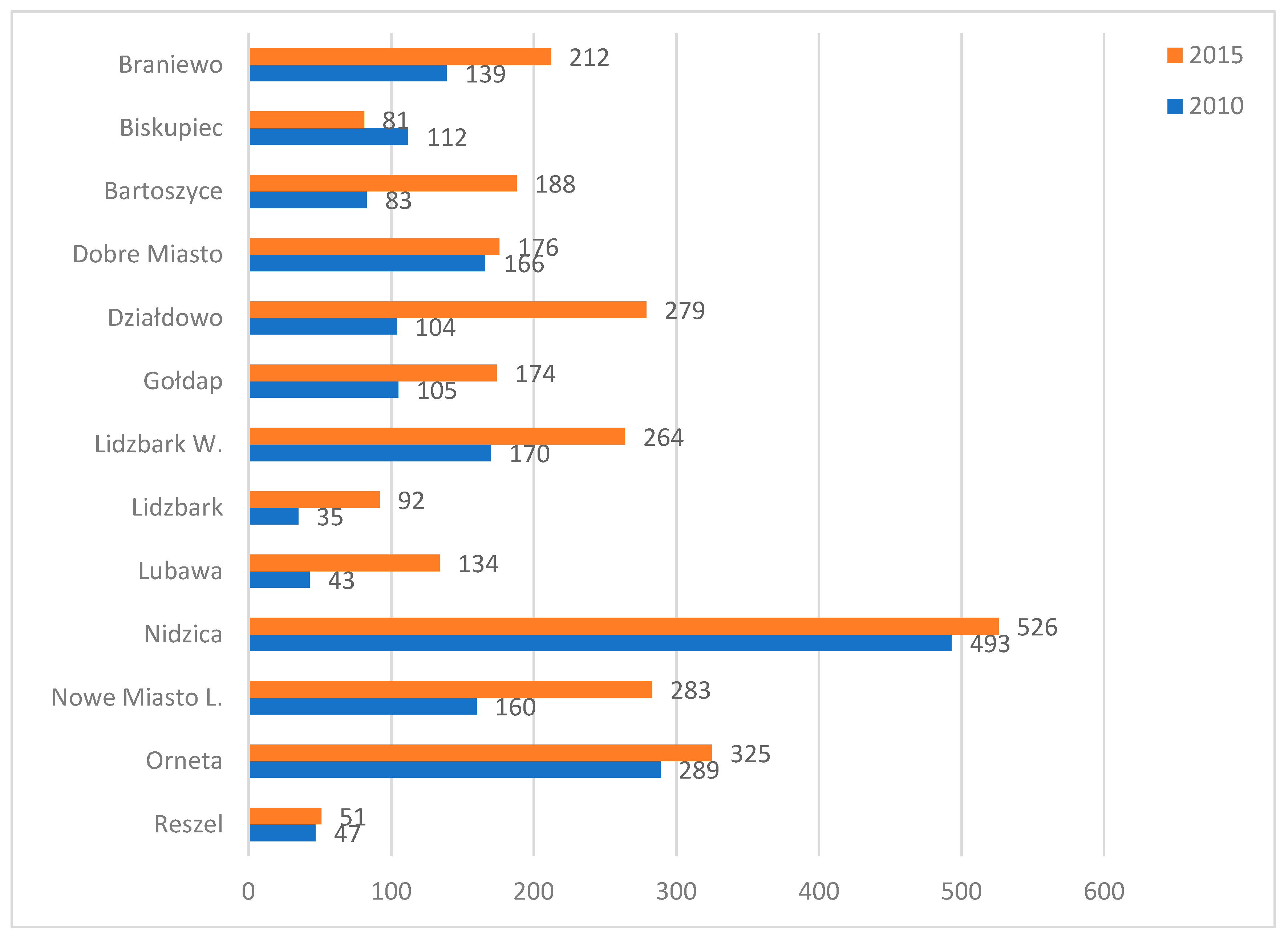
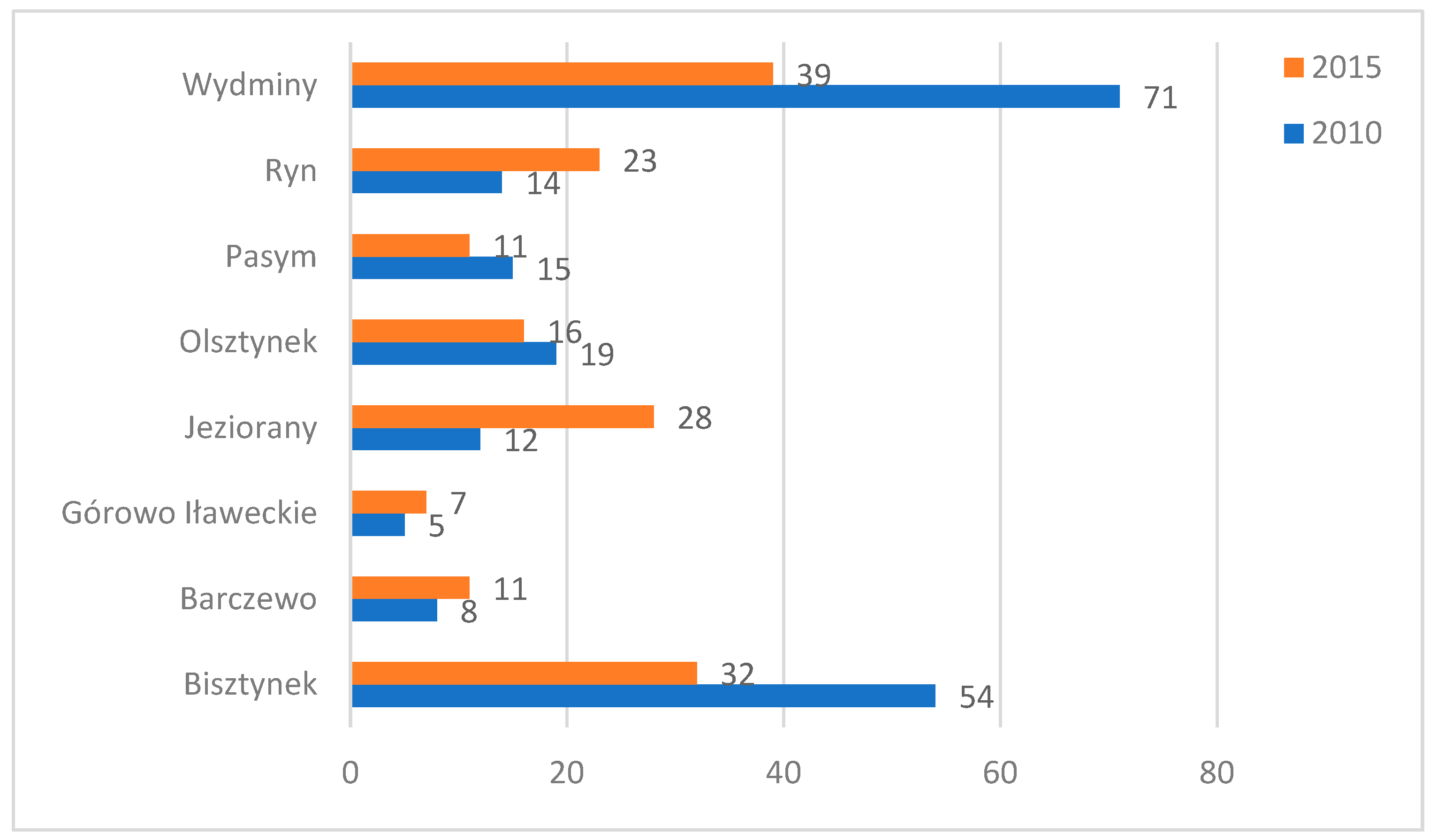
| No | Town | Road Category * | Study Area ** | ADT 2010 | ADT 2015 | Cycling Infrastructure |
|---|---|---|---|---|---|---|
| 1 | Braniewo | P | T | 139 | 212 | No dedicated infrastructure, cyclists use the pavement or road |
| 2 | Biskupiec | P | T | 112 | 81 | No dedicated infrastructure, cyclists use the pavement or road |
| 3 | Bartoszyce | P | T | 83 | 188 | In 2012 a walking and cycling zone was built, about 2 km long |
| 4 | Dobre Miasto | P | T | 166 | 176 | No dedicated infrastructure, cyclists use the pavement or road |
| 5 | Działdowo | P | T | 104 | 279 | In 2014 about 2.5 km of cycle paths were built |
| 6 | Gołdap | P | T | 105 | 174 | No dedicated infrastructure, cyclists use the pavement or road |
| 7 | Lidzbark Warmiński | P | T | 170 | 264 | In 2014 about 0.6 km of a walking and cycling zone were built |
| 8 | Lidzbark | P | T | 35 | 92 | About 1.2 km of cycle paths were built |
| 9 | Lubawa | P | T | 43 | 134 | In 2014 about 1.0 km of a walking and cycling zone was built |
| 10 | Nidzica | P | T | 493 | 526 | In 2014 about 6 km of a walking and cycling zone were built |
| 11 | Nowe Miasto Lubawskie | P | T | 160 | 283 | No dedicated infrastructure, cyclists use the pavement or road |
| 12. | Orneta | P | T | 289 | 325 | In 2014 about 2.0 km of a walking and cycling zone and 0.15 of a cycle path were built |
| 13 | Reszel | P | T | 47 | 51 | No dedicated infrastructure, cyclists use the road |
| 14 | Bisztynek | N | OT | 54 | 32 | No dedicated infrastructure, cyclists use the pavement or road |
| 15 | Barczewo | N | OT | 8 | 11 | No dedicated infrastructure, cyclists use the road |
| 16 | Górowo Iławeckie | P | OT | 5 | 7 | No dedicated infrastructure, cyclists use the road |
| 17 | Jeziorany | P | OT | 12 | 28 | No dedicated infrastructure, cyclists use the road |
| 18 | Olsztynek | N | OT | 19 | 16 | No dedicated infrastructure, cyclists use the road |
| 19 | Pasym | N | OT | 15 | 11 | No dedicated infrastructure, cyclists use the road |
| 20 | Ryn | P | OT | 16 | 20 | No dedicated infrastructure, cyclists use the road |
| 21 | Wydminy | P | OT | 71 | 39 | No dedicated infrastructure, cyclists use the road |
| Town | Better Links to Other Parts of the Town | Links into Existing Cycle Paths, Including Supra-Local Paths | |
|---|---|---|---|
| 1 | Barczewo | Y | N |
| 2 | Biskupiec | Y | N |
| 3 | Bisztynek | Y | - |
| 4 | Dobre Miasto | Y | N |
| 5 | Gołdap | Y | N |
| 6 | Górowo Iławeckie | Y | N |
| 7 | Lidzbark Warmiński | - | - |
| 8 | Lubawa | Y | N |
| 9 | Nidzica | - | - |
| 10 | Nowe Miasto Lubawskie | Y | N |
| 11 | Olsztynek | Y | N |
| 12 | Pasym | - | - |
| Town | Location | Objective Involving Cycling Infrastructure * | MP/SP/NP RPC ** | MP/SP/NP LRP *** | MP/SP/NP RPC **** | |
|---|---|---|---|---|---|---|
| 1 | Barczewo | 2 | Improve the pedestrian and cycle path in the Old Town | MP | SP | NP |
| Design of a pedestrian and cycle path with infrastructure along the river Pisa (2.5 km) | MP | SP | SP | |||
| 2 | Bartoszyce | - | - | No data | No data | N |
| 3 | Biskupiec | 4 | Planning of new cycle path in 4 locations in the town | MP | No data | SP (1 km of path |
| 4 | Bisztynek | 1 | Design of a cycling and educational route in an area of revitalisation, 4.2 km | MP | NP | NP |
| 5 | Dobre Miasto | 1 | Design of pedestrian and cycle paths along the river Łyna, 4.5 km (including pedestrian walks) | No data | No data | NP |
| 6 | Działdowo | - | - | No data | No data | NP |
| 7 | Gołdap | 1 | Build a well-lit cycle path and implement city bike project | SP | NP | NP |
| 8 | Górowo Iław. | 2 | Build a pedestrian and cycle path in the park In the river Młynówka valley | SP SP | NP MP | NP MP (0.7 km of path) |
| 9 | Jeziorany | - | - | No data | No data | NP |
| 10 | Lidzbark | - | Bike rental | No data | No data | SP |
| 11 | Lidzbark Wam. | None, in 2015 a section of a cycling route was built, part of the North East Poland cycling route (measure not part of the Programme) | NP | NP | NP | |
| 12 | Lubawa | 1 | Build a pedestrian and cycle path Zalew–Lipy, cycle path 3.05 km pedestrian and cycle path 0.4 km | MP | NP | NP |
| 13 | Nidzica | - | No planned cycle paths. The city centre is to be closed for motor traffic | NP | NP | NP |
| 14 | Nowe Miasto Lub. | 2 | Build a cycle path on post-railway site Build a bike station (bike rental) | M M | S S | N N |
| 15 | Olsztynek | 1 | Build a cycle path and buy bikes | M | S | N |
| 16 | Orneta | - | - | No data | No data | N |
| 17 | Pasym | - | No projects to build path infrastructure, pedestrian paths only | N | N | N |
| 18 | Reszel | 1 | Build pedestrian and cycle paths in the city park, 1.5 km long Improve the quality of cycle paths in the city centre | M S | M N | S N |
| 19 | Ryn | - | No projects to build cycle paths, improving lakeside pedestrian paths only | N | N | N |
© 2020 by the authors. Licensee MDPI, Basel, Switzerland. This article is an open access article distributed under the terms and conditions of the Creative Commons Attribution (CC BY) license (http://creativecommons.org/licenses/by/4.0/).
Share and Cite
Jaszczak, A.; Morawiak, A.; Żukowska, J. Cycling as a Sustainable Transport Alternative in Polish Cittaslow Towns. Sustainability 2020, 12, 5049. https://doi.org/10.3390/su12125049
Jaszczak A, Morawiak A, Żukowska J. Cycling as a Sustainable Transport Alternative in Polish Cittaslow Towns. Sustainability. 2020; 12(12):5049. https://doi.org/10.3390/su12125049
Chicago/Turabian StyleJaszczak, Agnieszka, Agnieszka Morawiak, and Joanna Żukowska. 2020. "Cycling as a Sustainable Transport Alternative in Polish Cittaslow Towns" Sustainability 12, no. 12: 5049. https://doi.org/10.3390/su12125049
APA StyleJaszczak, A., Morawiak, A., & Żukowska, J. (2020). Cycling as a Sustainable Transport Alternative in Polish Cittaslow Towns. Sustainability, 12(12), 5049. https://doi.org/10.3390/su12125049