Spatial Knowledge: A Potential to Enhance Public Participation?


1
Faculty of Geo-Information Science and Earth Observation (ITC), University of Twente, 7514 AE Enschede, The Netherlands
2
Regional Development Planning Agency (Bappeda) of Deli Serdang District, 20514 North Sumatra, Indonesia
*
Author to whom correspondence should be addressed.
Sustainability 2020, 12(12), 5025; https://doi.org/10.3390/su12125025
Submission received: 13 May 2020
/
Revised: 5 June 2020
/
Accepted: 17 June 2020
/
Published: 19 June 2020
(This article belongs to the Special Issue Sustainable Urban Planning Techniques)
Abstract
:Spatial knowledge, i.e., knowledge about space and place, is commonly used by stakeholders during the deliberative process of public participation practice. The goal of this article is to examine to what extent spatial knowledge exists and is used in a formal public participation practice, as well as its potential to enhance the public participation practice. We used an annual public participation practice in Indonesia called Musrenbang as the case study. Using a three-dimensional framework, we identified the types, levels, and socio-spatial relationships of spatial knowledge used in the Musrenbang practice. Our study finds that villagers had and used spatial knowledge during Musrenbang. However, the knowledge was not properly used due to three main impediments: The stakeholders were not aware of their spatial knowledge, spatial data was not available, which can help to better utilize knowledge while supporting the participatory process, and power gaps among stakeholders. It can be concluded that the development of suitable methods, which can help stakeholders use their spatial knowledge, is needed to enhance the current Musrenbang practice.
1. Introduction
Public participation is commonly applied in many countries to enable citizens to participate in decision-making processes. Despite its considerable utilization, there has been an extensive amount of literature that has discussed its shortcomings in implementation, including frequently failing to adequately facilitate deliberative processes among participants [1,2] and its proneness to elite capture [3,4]. Thus, citizens’ participation is becoming like a rubber stamp to fulfill the requirement of a participatory process [3,5]. Moreover, meetings often become ceremonial activities [6].
To overcome the shortcomings of public participation practice, some scholars suggest the utilization and improvement of spatial knowledge owned by the stakeholders involved in the process [7,8] as well as the use of geospatial data [9,10]. In public participation deliberative processes, spatial knowledge, which is the knowledge of how individuals, social groups, and institutions perceive particular places and their characteristics and meanings [11], is commonly used by people when illustrating specific locations to relate the discussion topic into the context [12]. Information about geographical space and place is frequently used, as individuals are firmly attached to the places where they live and participate in their activities [13]. Spatial knowledge is of significant importance because it carries not only information on geographic locations (space), but also on the meanings and experiences that people and communities have on those areas. Despite this growing interest, the characteristics of spatial knowledge owned by the actors in the public participation practice and how they use their spatial knowledge are not well understood, or are often neglected by scholars.
This study aims to examine to what extent spatial knowledge exists and is used in a formal public participation practice, as well as its potential to enhance the public participation practice. We use a participatory planning practice called Musrenbang in five villages located in Indonesia as the case study. Musrenbang is a participatory planning practice held annually to gain public inputs in the formulation of the village’s annual development planning and budgeting documents and proposals. The Musrenbang implementation commonly uses a public meeting format that is attended by various actors; government officials and citizens, community or religious leaders, local NGOs, and individuals from the private sector. During implementation, the literature shows some problems with the Musrenbang practice, such as limited knowledge sharing or integration among stakeholders [5,6], lack of data available to support the planning process [14], and power relations among participants [4,15].
This paper is organized as follows: The second section gives an overview of the relevance of spatial knowledge in public participation practice. The third section describes the methodology, case study, and framework used for analysis in this paper. The fourth section describes the results of the study, while the fifth and last section discusses the lessons learned and conclusions of the study. Three main questions are expected to be answered throughout this study: What are the spatial knowledge and geospatial data that the villagers have (or do not have)? How are they used in the Musrenbang practice (or how are they not used)? To what extent do spatial knowledge and geospatial data help to support public participation?
2. The Relevance of Spatial Knowledge for Public Participation
During the discussion on public participation practice, spatial knowledge is commonly used when referring to the location of a particular object. This section elaborates on the relevance between public participation practice and spatial knowledge to better understand the critical role of spatial knowledge in public participation practices.
2.1. Challenges in Public Participation
The implementation of public participation remains a challenge for practitioners and scientists. Kahila-Tani, Kytta, and Geertman [16] point out three main problems in public participation practice, including how to arrange effective public participation, how to engage more people in the process, and how to produce and exchange the knowledge effectively. First, arranging effective public participation is problematic, as there is ‘no one size fits all’ method to overcome the complexity of urban problems [17]. In the Musrenbang practice, the organizers often formally set the public meeting, with a tight schedule and limited topics of discussion [6,15]. Consequently, participation is not active. Furthermore, strict arrangements with limited space for direct involvement could cause a few people to engage in the process [1]. Adjusting the participatory method to suit the local context is needed, as it could influence the participants’ motivation to engage in participatory processes [18].
Second, any participatory methods aim to encourage more people to participate. However, involvement is not always successful, as there are always some people who are classified as the ‘silent majority’ among participants [19]. This silent majority mainly comes from the disadvantaged groups, who need to be empowered during participatory sessions [20]. This situation also occurs in the Musrenbang practices, where certain groups, particularly the elites and their supporters, tend to control the process [15]. Thus, it is vital to implement an inclusive process that ensures that different actors, issues, and sectors can work collaboratively to solve their common problems [21,22].
Third, scholars are often confronted with the question of how to produce and exchange knowledge effectively in public participation practices. As most human activities are situated in specific spatial contexts, spatial knowledge owned by stakeholders could be useful to enhance public participation practice [23,24]. At the same time, the geospatial data can help to gain optimum benefits of spatial knowledge utilization [9,25,26].
2.2. Spatial Knowledge
Spatial knowledge is practical knowledge about how people perceive the spatial concepts of interrelated facts, such as the identities of places and landmarks, network connections, directions, or distances between places [24,27]. People use this knowledge for many purposes, such as to get to destinations, to understand navigational directions, to understand and use maps, and to plan the shortest and efficient route of trips.
In a deliberative process of public participation, spatial knowledge is commonly used by stakeholders when referring to a particular geographical place that needs improvement. In Musrenbang, knowledge about places is essential, as it can determine whether a project proposal can be accommodated in the development plan and budget priorities [14]. Consequently, knowing distinct types and levels of spatial knowledge, as well as the socio-spatial relationships among different stakeholders when using spatial knowledge, are important to understand how spatial knowledge was used and how it can be amplified to improve current public participation practice.
2.2.1. Types of Spatial Knowledge
Theoretically, there are different types of spatial knowledge. Pfeffer et al. [24] divided spatial knowledge into four main categories: Tacit knowledge, community knowledge, sectoral knowledge, and expert knowledge (see Figure 1). Tacit knowledge is knowledge owned by people, whether laypeople or experts, which is often unexpressed or unwritten. Community knowledge is knowledge owned by people in a specific area concerning the context of the social, political, or spatial surroundings of the area. Sectoral knowledge is knowledge in particular sectors, such as farming or engineering, obtained from the experience or practice of professionals or practitioners. Expert knowledge is the codified knowledge owned or developed by academics or professionals [24].
2.2.2. Levels of Spatial Knowledge
Research in psychology has examined different levels of spatial knowledge. Many scholars are influenced by Siegel and White’s framework [28] to describe different levels of spatial knowledge. They classify spatial knowledge into three different levels: Landmarks, routes, and configurations [28], as can be seen in Figure 2.
The first level, landmarks, identifies the specific geographical location of an object. It is a visual representation for human adults and can be known without connecting a particular object to other objects [28]. People at this level are unable to draw the relative position of objects located in different places or to travel between places [29].
Through learning or experiences, one can move to the upper level of spatial knowledge, the route level. At this level, one can link one location to other locations and travel between places [30]. Individuals at this level still experience a lack of overall spatial understanding, even though occasionally they can still recognize or recall memories of the travel paths [29].
The next level focuses on the configurations of the landmarks and route levels [28] or what other scholars call the survey level [29,31,32]. At this level, individuals have mastered sufficient spatial understanding and are able to link and navigate between landmarks or places without being limited by travel paths [29,32]. The three levels are also relevant, with two main approaches focusing on how people use their spatial knowledge. The landmarks level is related to the object-based approach, while the route and survey levels are closely related to the space-based approach [33].
It is also important to note that the three levels of spatial knowledge show the development stages of how individuals acquire spatial knowledge rather than showing the hierarchy. Ishikawa and Montello [34] stated that spatial knowledge gained through adaptive ways helps us to adapt to the environment. This knowledge guides people to adjust their behavior to the environment, not only as perceived, but also as conceived and remembered [34]. The transition from one level to another level can be achieved through learning or experiences. In this paper, we refer to Siegel and White’s levels of spatial knowledge, as their theoretical framework is still relevant and dominant in spatial knowledge discourses [32,35].
2.2.3. Socio-Spatial Relationships
When discussing spatial knowledge, this concept cannot be separated from the interaction of people who own and use spatial knowledge and their relations with space. To understand these relations, it is crucial to conceptualize the connections between space as a geometrical form and society as a social relation form [36]. Humans build social relations in their everyday life, while space serves as a medium for people to do activities and develop their social relations. Schatzki [37] proposed the concept of social space to illustrate the strong relationship between space and people:
“Social space is a distribution of such items (objects, places, settings, action-governing factors, and causal transactions) among places and paths, which automatically happens along with interrelated lives and which underlies both the objective dimensions of social spatiality and the construction of the built environment”.(Schatzki 1991: 667)
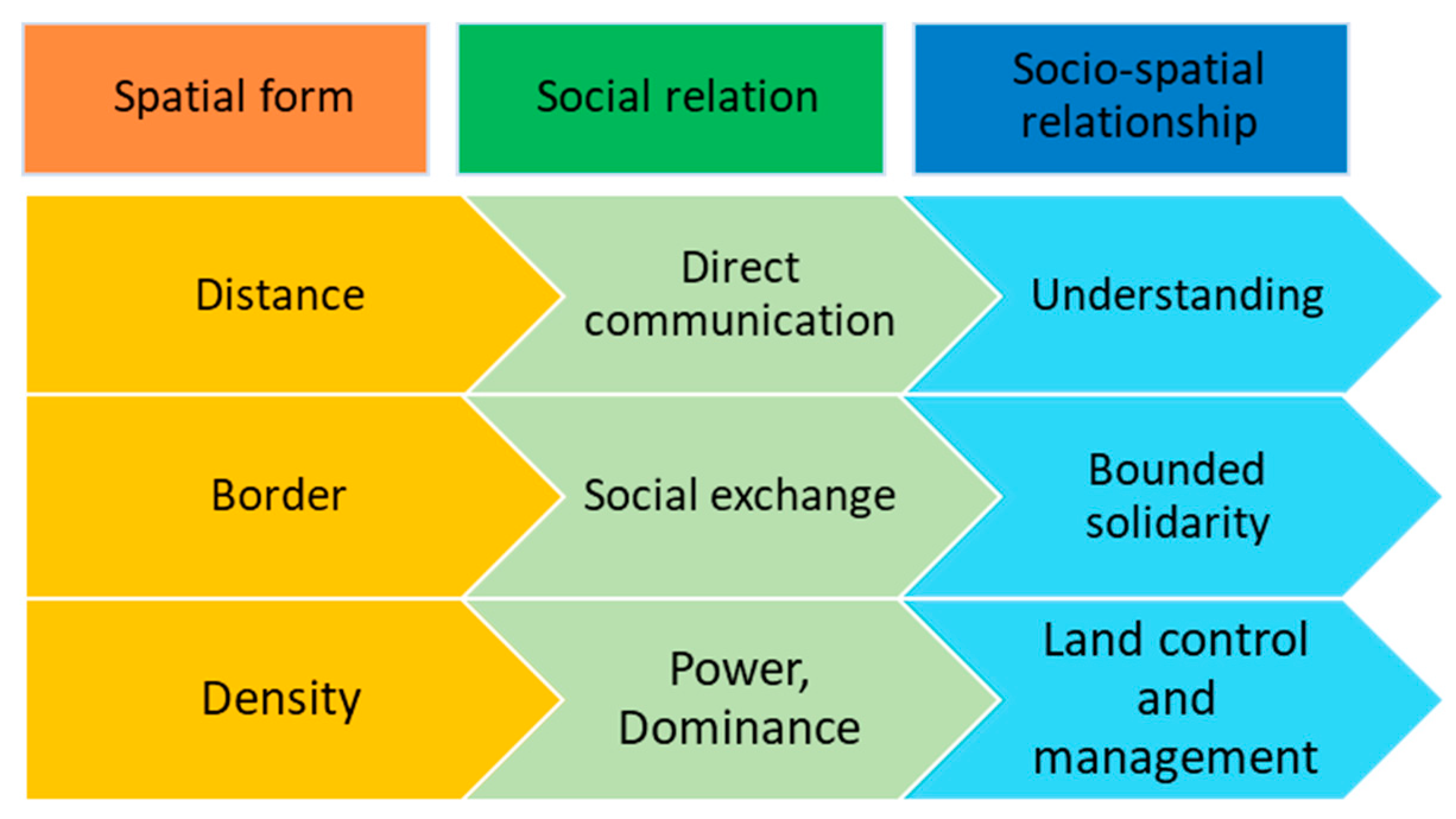
To better understand the connection between space and society, Osti [36] elaborated on the concept of socio-spatial relations through three dimensions: The spatial form, social relation, and the socio-spatial relationship (Figure 3).
To conceptualize the socio-spatial process, one cannot rely only on a single dimension. Socio-spatial relations must be viewed from different aspects, as they are mutually essential and interrelated with one and another [38]. Spatial elements, such as spatial proximity, accessibility, and connectivity, play a crucial role in supporting the performance or development of a region [39]. Therefore, the structural framework proposed by Osti suggests a clear distinction between three different but intertwined aspects that explain how space can affect people’s relations. Understanding among individuals who live distantly can be built through direct interactions [36]. The existence of borders can stimulate the exchange of knowledge and material flows, and strengthen the solidarity of the communities who live in the same region [40]. Dominance is commonly exercised through land use management to manifest the municipal officials’ strong position in power relations. As leaders, they must be able to examine the social form of their governed area, identify social relations between the communities, and finally put the policies and directions of the spatial forms that would bring positive impacts to regions [39].
3. Material and Methods
3.1. The Case Study
Musrenbang is an annual participatory planning and budgeting process implemented in different levels of governance, from the village level to the national level. At the village level, Musrenbang is implemented through a public meeting that involves various stakeholders with various backgrounds, interests, influence, and knowledge. In our previous study, we classified the stakeholders into four main groups, namely the upper government, village elites, village elites’ supporters, and ordinary citizens [15]. The planning process aims to produce the village’s annual development planning document, the financial plans, and development proposals for upper governments [4,6].
This study aims to investigate the utilization of spatial knowledge in the Musrenbang practices, including its potential to improve the current practice. To better understand the spatial knowledge of the village stakeholders and how the knowledge is used during the Musrenbang practice, we chose five villages in the Deli Serdang district in Indonesia. We purposely chose the villages based on their similarities in four different criteria: (1) The village is located in different sub-districts; (2) the ethnicity of the population is primarily Javanese; (3) the primary livelihood of the population is farming and agriculture; (4) the village officials are willing to participate in this study. Based on these criteria, the Denai Lama, Kolam, Kramat Gajah, Sidoharjo I Pasar Miring, and Tandem Hulu II were chosen as the case study locations.
3.2. A Framework to Examine Spatial Knowledge
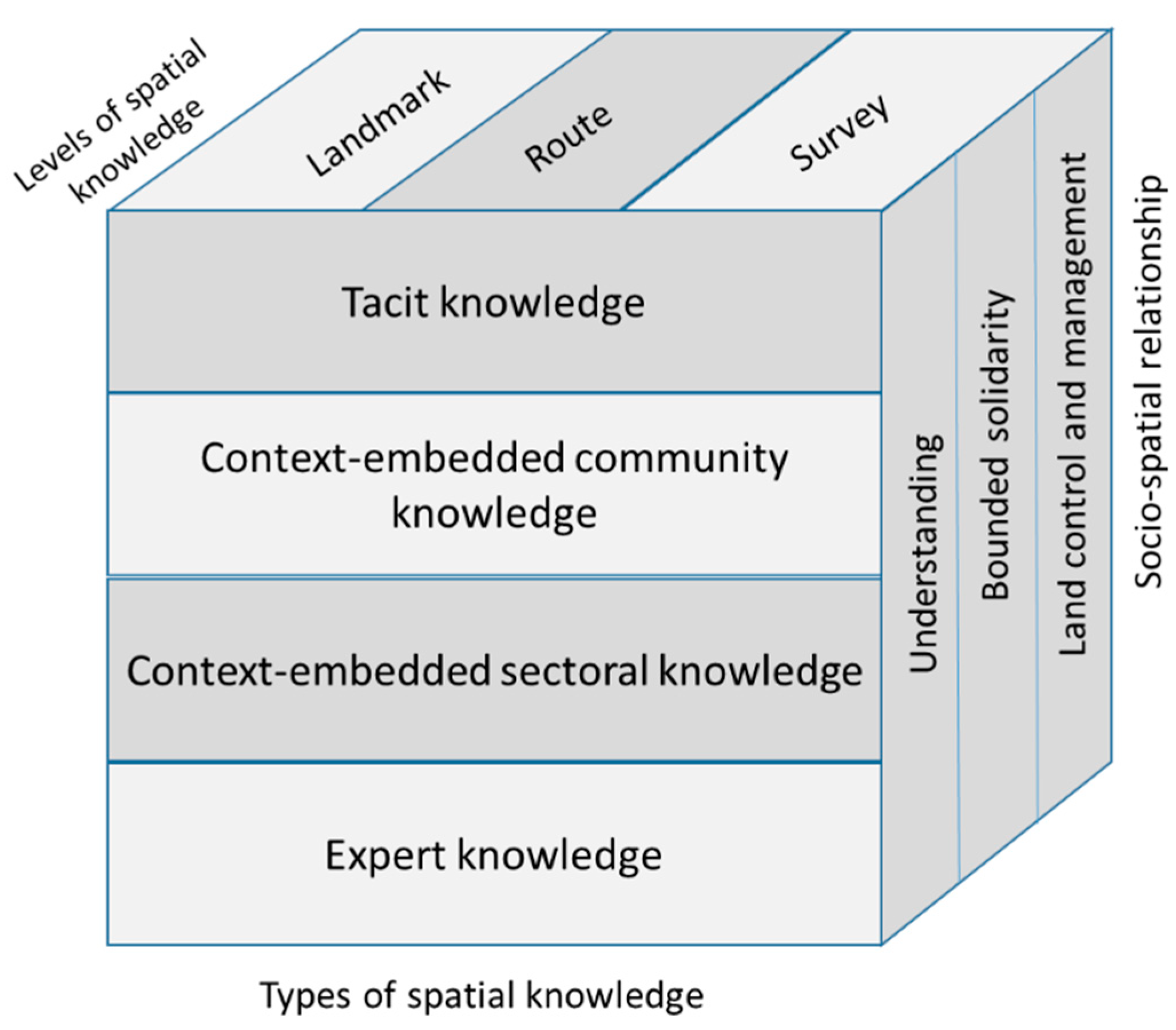
In pursuit of a generalized form of the spatial knowledge concept, which is more evidence-based, we employed a three-dimensional cube framework. The cube framework depicts spatial knowledge as a mutually dependent interplay between types, levels, and the socio-spatial relationship of spatial knowledge (Figure 4). The three-dimensional framework is useful to classify and identify the dynamics, actors, and activities involved in the utilization of spatial knowledge.
Examining the types and levels of spatial knowledge and socio-spatial relationships is necessary to understand the hierarchy and relations between different individuals and groups of stakeholders. This examination is also useful to understand the mechanisms and processes that influence the utilization of spatial knowledge. As the framework aims to encompass the salient aspects of spatial knowledge in the village context, this study also attempted to identify the geospatial data that are used, available, or accessible to the villagers to enrich the discussion.
3.3. Data Collection and Analysis
For the data collection, we used field observations, interviews, and focus group discussions (FGDs). The data were collected from January to May 2018, and we always asked participants/respondents’ informed consent before collecting the data. Based on the cube framework in Figure 4, we developed a set of criteria to examine the types and levels of the stakeholders’ spatial knowledge, as can be seen in Table 1. From the assessment criteria, a set of questions for the interviews and FGDs were also developed.
We conducted a stakeholder analysis for examining the socio-spatial relationship among the stakeholders of the Musrenbang practices. To obtain a more detailed understanding of the key stakeholders, firstly, we grouped the identified stakeholders according to their roles in the village Musrenbang practices, including their interest and influence based on the first author’s judgment. Using the semi-structured interviews and FGDs, we asked the respondent to identify the degree of interest and influence of each group of stakeholders and their reasons with regard to the utilization of spatial knowledge and geospatial data in the Musrenbang practices. We used the extended interest–influence matrix method to analyze the levels of interest and influence of the stakeholder groups [50]. The method is useful to differentiate a number of key stakeholders and provides comprehensive reasons for the interest and influence owned by each stakeholder [51].
The lead author acted as the direct observer in the observations by attending Musrenbang public meetings. The observations were written in field notes and recorded for further analysis. When observing the Musrenbang implementation, we also asked the participants to fill a self-administered questionnaire to collect their responses and opinions towards the Musrenbang implementation and the types of data used during the Musrenbang process (Appendix A). From the self-administered questionnaire, we gained the profile of the Musrenbang participants, as can be seen in Appendix B. The design of the questionnaire is based on previous research [15].
We conducted fifty-six semi-structured in-depth interviews and four FGDs to understand how the village stakeholders perceived spatial knowledge and how they used spatial knowledge in the Musrenbang (list of questions can be seen in Appendix C and Appendix D). Open-ended questions were used because this type of question allows respondents to answer in their own terms and provide new or unprecedented information that the researcher may not have contemplated [52]. The participants and respondents for FGDs and interviews were mostly villagers who have never had any experiences with interviews. Using the open-ended questions was helpful for the authors to interview the respondents with a certain set of questions derived from the case study design while keeping the respondents as comfortable as possible, as the interviews will be more like a usual daily conversation [53].
The participants/respondents were pre-selected by considering the representativeness of each group of stakeholders. The FGD’s participants consisted of village officials, a village council (BPD), the village empowerment board (LKMD), women representatives (PKK), youth representatives (Karang Taruna), community leaders, or religious leaders, and village supervisors. For the interviews, we also included the sub-district officials, district officials (Bappeda and DPMD), and a member of the district parliament (Appendix E).
The lead author took the interviewer or facilitator roles for all interviews and FGDs (see Figure 5). All the interviews and FGDs were recorded and transcribed for further analysis. The respondents’ names were kept anonymous. During the interviews and FGD sessions, we used a tablet and slide projector to show the respondents their village area on the default topographic map, satellite image maps, in Google Maps and Google Street View. We asked them to explore the maps, identify some important landmarks in the area, the location between two or more landmarks, and to manually draw a sketch map of their villages using a blank paper and a pen (Figure 5). Using the assessment criteria in Table 1, we classified the types and levels of spatial knowledge owned by the respondents as individuals and as a stakeholder group. We also asked them about the geospatial data they have or use, and the utilization of geospatial data in planning practices.
We employed qualitative content analysis to scrutinize the observation notes, interviews, and FGDs. A coding strategy was employed to use specific labels to categorize the respondents’ answers. We used axial coding themes based on the framework and open coding to ensure that the critical emerging aspects of the qualitative data were not missing [52]. The analysis was conducted iteratively using the ATLAS.ti software.
4. Results
Based on the observation, interviews, and FGDs, we achieved the following insights into how spatial knowledge exists and was used at the Musrenbang meeting.
4.1. Types, Levels of Spatial Knowledge, and Socio-Spatial Relationships of the Village Stakeholders
The results show that the types, levels, and socio-spatial relationships among the stakeholders play a significant role in the utilization of spatial knowledge in the Musrenbang practice.
4.1.1. Types of Spatial Knowledge
This study finds that all four types of spatial knowledge existed among the respondents (tacit, context-embedded community, context-embedded sectoral, and expert knowledge), and each individual had one or more types of spatial knowledge. The knowledge was acquired through their daily activities in or out of the village area, for instance, in their working place, formally or informally. The summary of the types of knowledge of all respondents (classified into stakeholder groups in Musrenbang) can be seen in Figure 6 below.
Figure 6 shows that all respondents have tacit knowledge. Based on the interviews and FGDs, it was evident that respondents often used their tacit knowledge during the Musrenbang and daily activities. They acquired and learned the knowledge through self-experience. Respondent B7 said in the interview, “I know exactly each part of the road heading to the Tembung area, which is in damaged condition. I know all the holes here and there” (B7, personal communication, February 26, 2018). Moreover, D1 responded:.
“Yes, they [the participants] have it [spatial knowledge]. It is because they often go there or pass by the area. I suppose that they know how many turns [to reach a specific place in the village], how many holes, where are the location of the mosque and the houses nearby the mosque they also know”.(D1, personal communication, 6 March 2018)
Examining the existence of tacit knowledge is a non-trivial task. Most respondents used their tacit knowledge intuitively when referring to a specific object in a particular location that was being discussed during the Musrenbang discussion. The tacit knowledge is a knowledge that is not easy to identify, as it is challenging to record, transfer, or communicate to other people [45]. The knowledge often remains implicit and unspoken, even though the owners may use the knowledge unwittingly in their daily activities.
The same phenomenon also occurred with context-embedded community knowledge; all respondents used community knowledge in their daily activities (see Figure 6). This knowledge is gained through social networks and interactions. From these interactions, new knowledge was transferred and exchanged, which eventually became common facts or knowledge among society. In this study, the existence of community knowledge can be found in the way our respondents described a specific place by linking the place with the information of ownership or the people who lived in nearby locations. For instance: “From end to end of this neighborhood, I am familiar with all the houses, the owners, how many children in each house, I know” (C5, personal communication, 7 March 2018). D4 gave the same response: “We know who the owners of all the houses in this village are and the inhabitants” (D4, personal communication, 6 March 2018).
The context-embedded knowledge is a knowledge that is commonly used during a participatory process. This knowledge is a valuable source that can reveal the realities within the communities. As this type of knowledge is usually acquired through social relations, it is quite useful to support the existing formal databases that governments have [42], to identify the exact locations of poor households, for example [44].
The context-embedded sectoral knowledge is commonly built through daily work or professional activities. Practitioners or professionals often create this type of knowledge from their experiences from practice [44]. When they get involved in participatory processes, they would use their professional skills to validate the information they gain during the process. For example, during Musrenbang, interviews, and FGDs, respondents with a government background tended to use terminologies related to governmental issues. In contrast, respondents from the farmers’ group tended to talk about irrigation or crop schedule. Providing a suitable method which can link variants of sectoral knowledge used by participants during the discussion becomes crucial. Giving the participants the opportunities to draw sketches [46] or rich pictures [54] may be useful to facilitate their communications while preventing the knowledge gaps among them.
Expert knowledge is the least type of spatial knowledge that can be found among communities. This type of knowledge is usually created through specific scientific protocols and codified by experts [44]. In Figure 6, most of the respondents at Musrenbang who had expert knowledge were respondents with a government background (upper government and village elites). As exemplified in the interviews, respondent D88 talked about the importance of maps in development planning and the laws that regulate the process (personal communication, 18 April 2018), while respondent D89 spoke about the laws that regulate the village planning stages and types of documents to be made (personal communication, 26 March 2018). Only a few participants demonstrated this type of knowledge during Musrenbang, as this knowledge was typically generated scientifically and acquired through formal education such as schools or training [24].
4.1.2. Levels of Spatial Knowledge
At the village level, our findings show that the levels of spatial knowledge were also varied. From the fifty-six respondents interviewed, there were five respondents at the landmarks level only, thirty-eight respondents attained the route level, and thirteen respondents exhibited characteristics consistent with the survey level (Figure 7).
All of the respondents possessed spatial knowledge at the landmarks level. Fifty-one respondents passed the landmarks level, while five respondents were still at this level. Most of the villagers have lived in the village for decades, so they know most of the primary landmarks, such as the village head office, health facility, mosque, schools, and the houses of the village government officers. During the interviews and FGDs, the respondents often used those landmarks for orientation when they identified information on the maps. The landmarks usually are attractive elements that are easy to identify, and often situated in locations where people would pay more attention [46].
The majority of the respondents were on the route level. They could identify several landmarks within the village and could instantly provide information about the shortest route to connect those landmarks.
“We know about every place in this village, as we have traveled or passed by most of the areas. For example, if we want to go to Neighborhood 1, after passing by the village head office, we will find a T-junction. If we turn right, we are heading to Neighborhood 3. If we turn left, we are heading to Neighborhood 1, and it will end up at the village border, which is the Denai Sarang Burung village, our neighbor village”.(A1, personal communication, 1 March 2018)
“This is Mawar Street, this is Balai Desa Street. This is the road heading to Neighborhood 4. If we go North, we will get Neighborhood 3, then this is the [village] border. This is the rice mill”.(A6, personal communication, 1 March 2018)
The statements above clearly show that most participants who demonstrated characteristics of route level acquired the knowledge when they regularly navigate along a specific travel path. They memorize the information on the travel paths during the journeys through an egocentric perspective. The egocentric perspective is useful for acquiring the route spatial knowledge as it represents the location of objects in space relative to the viewpoint of our eyes [46].
While the route level is commonly obtained and used through an egocentric perspective, the survey level is often practiced through the allocentric view [34]. Individuals at the survey level typically can interpret or use two-dimensional maps [27], which are in line with our findings that show respondents at the survey level are mostly government officials. Their duties as government employees require them to be able to use and interpret maps to support their jobs. When we asked them to read the digital maps displayed on the tablet during the interviews, they can point out several landmarks and explain the distance and travel paths that connect different landmarks. As an example, A1 said, “Yes, I can read the [Google] map. This is the village head office. This is the rice mill. I was part of the team that made the first [sketch] map of this village (A1, personal communication, 1 March 2018).
Our findings also revealed that participants reacted faster to identify the landmarks or routes when we used the Google Street View than the Google Maps in the interviews and FGDs. The Google Street View supports the egocentric perspective, while the Google Map supports the allocentric view, which is not easy to interpret. We also found that age differences are crucial to executing the given tasks. Younger respondents have a better ability than older participants to understand the maps provided in the Google Map platform. Younger respondents have more opportunities to be exposed to the rapid development of new technologies nowadays, enabling them to better interact with the virtual geo-technology means [46].
4.1.3. Socio-Spatial Relationships of the Village Stakeholders
Most respondents are quite familiar with their village areas. However, the village officials, head of neighborhoods, and women respondents demonstrated more knowledge about the village than other respondents. The village officials and heads of neighborhoods knew about their areas because their duties force them to understand their governing areas. When working on their duties, the head of the neighborhoods often goes to the neighborhoods to identify and list the programs needed by citizens, working with the land administration and registration, to survey and measure the length, width, or depth of a specific location in the village (B1, personal communication, 5 March 2018).
The women have more extensive knowledge of the area, as they spend most of their time in the villages where they can exercise and extend their social network with other village stakeholders [15]. Respondent C5, for instance, said that they know the exact location of each house in their neighborhoods, who the owners are, and who the individuals living in the house are (C5, personal communication, 7 March 2018). Direct face-to-face communication has a significant role in enabling individuals or groups to have a better understanding of their living space and its surroundings.
From the responses, it seems that the respondents often refer to the village border when identifying landmarks or routes. Borders or boundaries are essential for location orientation in the village. For instance, when we asked a woman representative from the Denai Lama village to explain the route from the village head office to her house, she used the village border for orientating her route.
“So, from Denai Sarang Burung [village neighbor], this is the village border. We are going straight. Only the main roads, right? We will pass a mosque, then we simply follow the roads, we find a junction, we turn right to the village head office, passing the office, then we turn right, go straight follow the road heading here, so here we are”.(A5, personal communication, 8 March 2018)
Borders are also essential to claim the existence of activities managed by stakeholder groups. Farmer groups, for example, also have sketch maps to illustrate the rice fields in the village (D8, personal communication, 7 March 2018). This finding is aligned with Osti’s framework, as the border can create bounded solidarity among the people who live in a particular area [36]. Some respondents also stated administrative boundaries as an underlying problem that can provoke conflicts between neighborhoods, villages, or sub-districts. In Denai Lama, disputes have arisen in the past, and until now, the border problem with their neighbors still exists (A1, A2, personal communication, 1 March 2018). Delineating boundaries is essential to decide the scope of development planning as well as reducing conflicts over administrative areas [43].
Regarding power relations, our findings show that various stakeholders were involved in village Musrenbang practices. We classified them into four main stakeholder groups, as can be seen in Table 2 below.
Table 1 clearly shows the stakeholders’ positive and negative influence on the utilization of spatial knowledge and spatial data at the Musrenbang. Each group of stakeholders has different interests and influences towards the process, which potentially creates gaps and conflicts among them.
In the village Musrenbang, the village elites play a vital role in controlling the discussion. The regulation gives them the right to enlist programs that need to be prioritized. As they have better knowledge about the regulations and the village’s geographical locations of the proposed projects, most of the programs listed by the elites are often agreed upon by the participants. However, only slight adjustments can be made to the list since the result of the discussion at the Musrenbang is only considered as recommendations that are not binding.
4.2. Use of Spatial Knowledge and Geospatial Data in the Musrenbang
Our findings revealed that spatial knowledge was used during the Musrenbang discussion. Below are two examples of participants’ responses to the question of how spatial knowledge was used at the Musrenbang:
“When a participant said that they need to build an asphalt road in a specific area, we can visualize that area in our mind instinctively as we have traveled to that area a couple of times and we know the road condition is severe. So, the project is urgent. Yes, I think spatial knowledge is used”.(B5, personal communication, 4 March 2018)
“They use (spatial) knowledge (in Musrenbang). Even though they do not know the exact length of the irrigation tunnel, they already know where the location of the flooding is. They know that it happens due to no tunnel being available to discharge the water. So, they used their [spatial] knowledge”.(A2, personal communication, 1 March 2018)
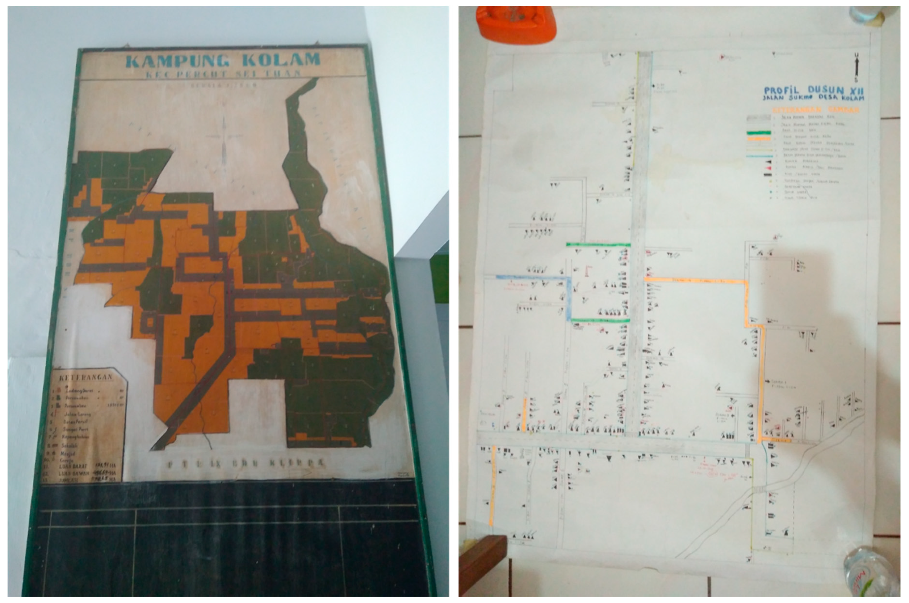
From the responses above, it is evident that during the Musrenbang discussion, when someone at the meeting mentions a particular place within the village, the participants often unwittingly use their spatial knowledge to identify the place. However, the utilization of spatial knowledge was not optimal due to a lack of geospatial data in the villages. They have village sketch maps, hand-drawn without proper scales or coordinates, but the maps were never used at the Musrenbang. All of the village maps are hanging on the wall of the village office, so basically, they are used for office decoration only (see Figure 8). We only found one respondent who created his own hand-drawn neighborhood map. The map depicts the situation of the neighborhood with all the houses, infrastructure, roads, and alleys (Figure 8). The map is regularly updated and only for internal use for visualizing the situation of the neighborhood (B3, personal communication, 5 March 2018).
Further, we asked the respondents about the potential use of maps during the Musrenbang discussion. Most respondents gave positive feedback towards our question, as can be seen in Figure 9.
Some respondents described their reasons why they think using maps would be useful to enhance Musrenbang implementation. Spatial data like maps would be helpful to visualize the geographical locations of the Musrenbang projects, which are being discussed (A8, personal communication, 8 March 2018). The visualization could stimulate the discussion, as now participants can see the spatial distribution of the project’s locations (B5, personal communication, 4 April 2018). A6 implied that by using maps, the discussion would be more productive. Showing the village maps during the Musrenbang may result in additional opinions to ensure the allocation of projects is to be more equitably distributed and solve the most urgent problems that the village may have (A6, personal communication, 1 March 2019). Martinez et al. [44] suggested that maps would be useful to stimulate in-depth discussions while enriching the debates among stakeholders.
4.3. To what Extent do Spatial Knowledge and Geospatial data Support the Participatory Processes?
Even though the stakeholders were often unconsciously using their spatial knowledge during the discussions, the respondents admitted that spatial knowledge is useful to help them in identifying particular places during the Musrenbang discussion.
“For example, when someone said Masjid Street, our mind starts to think about where it is. Oh, it is at the village border. The border is around some kilometers away from here. So, it [the location] just comes up. When somebody talks about that place, we can simply imagine it. We do not see it physically, but we can see it through our minds”.(A9, personal communication, 8 March 2018)
C3 expressed that even without any supporting pictures or visiting the area, they could imagine a particular place in the village because they are very familiar with the area (personal communication, 7 March 2018). The same response was given by D1, who said that participants could visualize a location even though they were not in that specific place, as it is automatically visualized in their minds (personal communication, 6 March 2018). However, their knowledge was not acquired through formal learning; they gained this kind of knowledge from their daily interaction with the other people in the village and unintentionally memorized the information gained through these interactions (B1, personal communication, 5 March 2018).
These responses show clear examples of how tacit knowledge is transformed into community knowledge. A person tacitly knows a place and the people who live nearby based on his/her experiences. When they interact with other people, they express their tacit knowledge, which then becomes explicit. As a result, the people with whom he/she interacts gains new knowledge from the conversation. Thus, social networks play an essential role in utilizing and acquiring the community’s spatial knowledge as well as transforming tacit knowledge into becoming explicit.
When we asked the participants about their support towards the idea to produce village maps through a participatory mapping exercise, ordinary citizens showed high acceptance. In contrast, the upper government, village elites, and their supporters showed hesitation towards the idea to involve the citizens in the participatory mapping activities (Figure 10).
During the interviews, when we asked for reasons for the hesitation, E1 responded that ordinary citizens have no time to engage in social activities, like a participatory mapping exercise (E1, personal communication, 3 May 2018). The same response was given by B5, who said, “[We] do not need to involve the citizens. Just involve the village officers, BPD, LKMD, and the head of neighborhoods to create the maps” (B5, personal communication, 4 April 2018). Another respondent stated, “Only [involve] the governments. Creating maps needs a specialized expertise. If we involve the ordinary citizens, it will be very difficult to create the maps” (E4, personal communication, 6 April 2018). Involving citizens is quite tricky. E3 implied that if citizens see the development gaps among neighborhoods on the maps, this could trigger concerns and protests from the Musrenbang participants (E3, personal communication, 2 May 2018). Thus, this could be one of the reasons why the village elites and their supporters prefer to limit the participation of ordinary citizens in participatory mapping activities. Developing a participatory mapping method that can facilitate the integration of various spatial knowledge while minimizing power inequalities is not straightforward but necessary. The engagement in the participatory mapping activities should not only aim to enhance the participants’ spatial understanding about their villages but also accommodating different interests and influences of the stakeholders in the village [44].
It appears that the survey level moves beyond what is placed at a certain location (landmarks level). Community members that operate at the survey level, by understanding the landscape in a holistic manner, are also able to know why and how changes in a specific location may have an impact in some parts of the village. Involving the people who are at the survey level would enrich a participatory mapping exercise and make the mapping process more efficient [55]. The selection of participants for the participatory mapping exercise should not only consider the representativeness of the stakeholders in the region, but also needs to consider the level of spatial knowledge that an individual may have.
5. Discussion
In this research, we identified how various groups of stakeholders have and make use of different types, levels of spatial knowledge, and socio-spatial relations. These three different dimensions are mutually connected and show the capability of each group of stakeholders in perceiving and utilizing their spatial knowledge. Three main challenges need further actions to optimize the spatial knowledge used by the village stakeholders.
5.1. Spatial Knowledge is used in Musrenbang, but not Properly Used
The participants of Musrenbang have distinct types and levels of spatial knowledge, but they are not aware of its potential in helping them in planning processes. The interviews and FGDs in this study were useful to raise awareness of the valuable knowledge that could be used to help them better participate in the Musrenbang practice.
As an annual public meeting prescribed by the laws 25/2004, the participatory process in Musrenbang is still far from ideal. An ideal public participation practice should allow participants to share their ideas and opinions [19,21], as well as supporting mutual communication and collaboration among them [13,56]. In the implementation, as Indonesian villages have characteristics associated with stronger social networks [5], the village elites typically have full control to direct the conversation and make final decisions. The ‘silent majority’ among the participants, mostly ordinary citizens from marginalized groups, remains uninvolved [4,19,20].
However, this situation did not prevent village stakeholders from using their spatial knowledge. As the topics of discussion in Musrenbang cannot be separated from discussing specific geographical places, by nature, discussion about places would contribute to stimulating the participants to use their spatial knowledge, tacitly or explicitly. The active usage of spatial knowledge provides the potential for the knowledge co-production process. Previous studies have shown good examples, such as the knowledge co-production to solve the pollution issue in Durban [24], to collect toponym information in Indonesia [57,58], or to tackle environmental burdens in Dortmund urban areas [54],
How to effectively use spatial knowledge is also a challenge. Our results reveal that most of the participants in Musrenbang limited their focus mainly on their own neighborhoods, giving the impression that the spatial boundaries have a significant influence on the formation of bounded solidarity within a community. Consequently, they did not put any attention to projects implemented in a broader context, such as in other neighborhoods or at the village scope. Redesigning the participatory method that engages as many as participants as possible [17,59] and meets the local context [18,60] could be a solution to achieving a better participatory process. For example, the proposed method should acknowledge the importance of borders for villagers, as borders have complex social constructions with various implications for society, not only simple lines/signs in space or on maps [61].
Further, the design of the participatory method should also enable the village stakeholders to think systematically to leverage their voices in the decision-making process [55]. Thus, rather than only knowing about where the location of a healthcare facility is, for instance, the participants should also be able to use their spatial knowledge to understand the impact of maps for other development purposes. For example, they can use their spatial knowledge to identify the best location for the new healthcare facility, or to assess how the relocation of a traditional market to a new site can affect the transportation routes of their villages.
5.2. Codifying Knowledge to Integrate the Local Spatial Knowledge and Support the Musrenbang Practice
Data availability is crucial to support public participation practices. However, data availability is commonly limited [26] or inaccessible for users [62]. In Musrenbang, each project discussed often has information about the name of the project, quantity, and location of the project. Nevertheless, in all five villages, there was no spatial data/information, such as maps, available to support the discussion about the project.
Lack of codified knowledge, like maps, caused the participants to not pay attention to the topics discussed, as they lost interest in the issues, particularly as they put more concern on their own neighborhoods’ issues. Eventually, the public meeting as a means of participation is subverted in practice, as the elites could smoothly steer the decision-making process more favorably for themselves [4,14].
Most of the respondents gave positive responses to the utilization of geospatial data in the Musrenbang. However, they were confronted with the fact that there is no or limited geospatial data available in the villages. The question is now how to codify and make spatial data available. Nowadays, the production and use of spatial data have shifted from only an expert-driven process to a process where organizations or citizens worldwide can get involved [23,63]. For instance, the universal use of spatial data applications, such as Google Maps and Open Street Map, allows people to become an active contributor to spatial data [57,64,65]. Despite broader access to various types of online geospatial data and information, we found that the village stakeholders did not make use of the available data to enhance the decision-making process. Age could be a primary impediment to the use or manipulation of those types of online geospatial data [46]. Most of the village elites are older people, while the youth citizens seldom have essential positions at the elites’ level as well as rarely engage in public participation practices. Lack of access to the internet is another problem. Many citizens in rural areas, especially the elderly, tend to show hesitation to install internet connections at home or even use the internet on their mobile phones. The internet connections in rural areas are often less stable, while infrastructure needed to provide a stable internet connection might be costly for most internet service providers. Consequently, these circumstances hinder the optimal use of free-available geospatial data to enhance the spatial knowledge of the stakeholders and to improve the current Musrenbang practices.
Involving the stakeholders of Musrenbang in a co-production process to produce their own spatial data into codified knowledge has the potential to solve data availability problems. The co-production of spatial knowledge to produce joint data/information could help enrich public participation practices. Participants with different backgrounds could contribute by solving common problems faced by communities [54,66,67], increasing trust [56], nurturing a sense of belonging [22], ensuring more sustainable land management decisions [23], and promoting the optimal use of spatial knowledge [24]. Ultimately, the valuable tacit, community, sectoral, and expert spatial knowledge owned by diverse stakeholders could be transformed into codified knowledge.
5.3. Willingness to Use Spatial Knowledge among Stakeholders of Musrenbang
Further typical questions when initiating participatory processes, such as knowledge co-production, are how significant the (upper) government commitments to support the process of knowledge exchange among stakeholders are. As prescribed by the law 6/2014, each village must have three types of maps: The satellite image, infrastructure/facilities, and land use/land cover maps. Although stated by laws, the upper government typically put their attention to other tangible developmental priorities, particularly for infrastructure [68], and did not take any actions to support the production of village maps.
At the village level, the village elites gave positive responses to the use of spatial data in the Musrenbang process. As discussed in the previous section, spatial data can be produced through knowledge co-production activities, such as participatory mapping [55]. However, our findings reveal that half of the respondents from the village elites’ group showed hesitation to involve many as participants in the participatory mapping exercise. They preferred only to include the village elites and their supporters. It seems that the elites are a bit concerned about losing their control over ordinary citizens. Maps could threaten the elites’ authority and raise citizens’ concerns towards the policies made by elites, for instance, criticizing the fairness of project distributions in all neighborhoods. There are many cases where participatory mapping exercises lead to counter-mapping activities that could challenge powerful elites [62,69]. Moreover, there may be a concern for the elites that co-production processes could sacrifice the provisions of the services [70]; in this case, the quality of the village map produced may be lower than the expected standard.
On the other hand, ordinary citizens have the confidence to utilize spatial data and information during the Musrenbang practice, as well as to participate in the map-making process. However, their main concern is how to produce maps without the capability of creating maps with proper coordinates and projections. The availability of map experts is essential for the sustainability of a participatory mapping project [71,72].
6. Conclusions
Our research introduces a feasible and straightforward framework to better understand the stakeholders’ spatial knowledge and how they use knowledge in a public participation practice. The developed framework is universal, as it portrays spatial knowledge as a mutually dependent interplay between types, levels, and the socio-spatial relationship of spatial knowledge. The framework enables the authors to examine the dynamics, actors, and activities involved in the utilization of spatial knowledge in public participation practices. The framework has the potential to be used elsewhere, of course, by adjusting or modifying certain aspects to meet the real context of other localities. For example, when applying the framework in urban areas, using an online assessment form is possible since the urban population tends to be more adaptable and open to online and virtual communication.
We recognize that this study has limitations. When assessing the types and levels of respondents’ spatial knowledge in the interviews, the tools that we used were only a tablet to display the maps, and pens and blank sheets of paper for respondents to draw a sketch map. As the acquisition of spatial knowledge is highly related to the human cognitive aspects [30,33], using a device that allows respondents to experience the navigational experiences, such as mobile mapping tools, might be more powerful to examine the respondents’ spatial knowledge [46,59,67].
This paper confirms that most respondents agree that spatial knowledge has the potential to enhance public participation, particularly the current Musrenbang practice. The participants, with better use of their spatial knowledge, can better engage in a fruitful discussion during the Musrenbang, which leads to better decision-making processes. For example, they can locate specific issues on the maps, examining the impacts of particular projects in the village area, or creating a more equitable funding allocation for all neighborhoods. Further, better use of spatial knowledge could stimulate more in-depth discussions and collaboration between participants in other village development projects, especially when supported with sufficient and accurate geospatial data.
Knowing the types, levels, and socio-spatial relationships among stakeholders provides a profound understanding of identifying better methods to utilize and integrate stakeholders’ spatial knowledge. Developing a suitable method, i.e., the participatory mapping, could enable stakeholders to express their spatial knowledge while stimulating collaboration between ordinary citizens and the elites. The collaboration should put attention on the local context and consider the characteristics of different stakeholders in using their spatial knowledge. In the long run, the collaboration could also solve the problem of a lack of geospatial data in the villages. This study calls for further research to explore the most effective way to manage the potential of spatial knowledge of stakeholders in codifying their knowledge and utilizing the knowledge in real practice, like public participation processes.
Author Contributions
Conceptualization, A.A., J.F., J.M., M.F.A.M.v.M.; data curation, A.A.; methodology, A.A.; validation, A.A.; formal analysis, A.A.; writing—original draft preparation, A.A.; writing—review and editing, J.F., J.M.; visualization, A.A.; supervision, J.F., J.M., M.F.A.M.v.M. All authors have read and agreed to the published version of the manuscript.
Funding
This research was funded by Ministry of Finance for the Republic of Indonesia’s Indonesian Endowment Fund for Education (LPDP), grant number PRJ-561/LPDP/2015.
Acknowledgments
We would like to thank the Ministry of Finance for the Republic of Indonesia’s Indonesian Endowment Fund for Education (LPDP) for supporting this research. We thank all the respondents in Deli Serdang district that enthusiastically responded to our questions and helped our fieldwork. We also thank the anonym reviewers for providing useful comments that helped to improve the paper.
Conflicts of Interest
The authors declare no conflict of interest.
Appendix A
Self-Completion Questionnaire
Musrenbang in ………………. Village Date: ………….………
A. Respondent’s Identity
Please fill in the blank or choose one answer that best represents your views by circling it.
- How old are you?.......... old
- Sexa. Male b. Female
- Education level:a. SD b. SMP c. SMA/SMK d. Diploma e. S-1 f. S-2 g. S-3
- Races …………………………
- Please explain briefly what is your role in the Musrenbang? Representing which stakeholders?…………………………………………………………………………………………….
B. Respondent’s Point of View towards the Musrenbang Implementation
Please put a tick (✓) in the box next to one answer that best represents your views (i.e., SA ☑). If you have further comments, please fill the dots provided in each statement.
(SA = Strongly Agree; A = Agree; U = Undecided; D = Disagree; SD = Strongly Disagree)
- The goal of the Musrenbang is clear for me.SA ☐ A ☐ U ☐ D ☐ SD ☐Comments:…………………………………………………………………………………………………………
- The Musrenbang process was made transparent for me.SA ☐ A ☐ U ☐ D ☐ SD ☐Comments:…………………………………………………………………………………………………………
- Rules of the Musrenbang were agreed in advance by the participants.SA ☐ A ☐ U ☐ D ☐ SD ☐Comments:…………………………………………………………………………………………………………
- I could identify the real problems faced by our villages in an integrated and comprehensive way.SA ☐ A ☐ U ☐ D ☐ SD ☐Please explain…………………………………………………………………………………………………………
- The participants invited to Musrenbang have represented all important stakeholders in the villageSA ☐ A ☐ U ☐ D ☐ SD ☐If not, who else should be involved?................................................................................................................………
- Each participant has the same opportunities to have a say at the meeting.SA ☐ A ☐ U ☐ D ☐ SD ☐If not, why?……………………………………………………………………………………………………….
- Certain individuals tend to dominate the deliberative processes.SA ☐ A ☐ U ☐ D ☐ SD ☐Who were more dominant?……………………………………………………………………………………………………….Who were less dominant?……………………………………………………………………………………………………….
- There were little opportunities to share knowledge among participants.SA ☐ A ☐ U ☐ D ☐ SD ☐Comments:………………………………………………………………………………………………………
- Different opinions were not integrated well in the discussion.SA ☐ A ☐ U ☐ D ☐ SD ☐Why? Please explain……………………………………………………………………………………………………….
- Decisions were not made through consensus of participants.SA ☐ A ☐ U ☐ D ☐ SD ☐Why? Please explain ………………………………………………………………………………..
- Data/information (i.e., maps, graphs, pictures, audio, etc.) to support the deliberative and decision making processes was not available.SA ☐ A ☐ U ☐ D ☐ SD ☐If available, what kind of data/information was provided?…………………………………………………………………………………………………………..If NOT available, what kind of data/information that should be available to support the process?…………………………………………………………………………………………………………..
- Data/information is needed to support the deliberative processes and decision making.SA ☐ A ☐ U ☐ D ☐ SD ☐Please explain…………………………………………………………………………………………………………..
- I learned nothing from other Musrenbang participants.SA ☐ A ☐ U ☐ D ☐ SD ☐Please explain………………………………………………………………………………………………………….
- Common understanding was built among participants.SA ☐ A ☐ U ☐ D ☐ SD ☐Please explain………………………………………………………………………………………………………….
- Budget allocation for public capital is still limited.SA ☐ A ☐ U ☐ D ☐ SD ☐Why? Please explain ………………………………………………………………………………….
Appendix B

Table A1.
Profiles of the Musrenbang’s participants in five villages.
| Attributes | Villages | |||||||||
|---|---|---|---|---|---|---|---|---|---|---|
| Denai Lama (n = 49) | Kolam (n = 56) | Kramat Gajah (n = 34) | Sidoharjo I Pasar Miring (n = 60) | Tandem Hulu II (n = 28) | ||||||
| Freq | % | Freq | % | Freq | % | Freq | % | Freq | % | |
| Age (year) | ||||||||||
| <21 | - | - | - | - | - | - | - | - | - | - |
| 21–30 | 7 | 17,9 | 3 | 5,5 | 3 | 9,7 | 1 | 2,3 | 1 | 4,0 |
| 31–40 | 13 | 33,3 | 9 | 16,4 | 8 | 25,8 | 10 | 22,7 | 7 | 28,0 |
| 41–50 | 16 | 41,0 | 33 | 60,0 | 14 | 45,2 | 18 | 40,9 | 13 | 52,0 |
| 51–60 | 3 | 7,7 | 5 | 9,1 | 4 | 12,9 | 12 | 27,3 | 4 | 16,0 |
| >60 | - | - | 5 | 9,1 | 2 | 6,5 | 3 | 6,8 | - | - |
| Sex | ||||||||||
| Male | 33 | 84,6 | 44 | 80,0 | 14 | 45,2 | 24 | 54,5 | 18 | 72,0 |
| Female | 6 | 15,4 | 11 | 20,0 | 17 | 54,8 | 20 | 45,5 | 7 | 28,0 |
| Education | ||||||||||
| SD (Elementary school) | 4 | 10,3 | 3 | 5,5 | - | - | 2 | 4,5 | - | - |
| SMP (Junior High School) | 9 | 23,1 | 13 | 23,6 | 12 | 38,7 | 10 | 22,7 | 1 | 4,0 |
| SMA (Senior High School) | 19 | 48,7 | 22 | 40,0 | 13 | 41,9 | 22 | 50,0 | 14 | 56,0 |
| Diploma | 1 | 2,6 | 4 | 7,3 | 2 | 6,5 | 3 | 6,8 | 2 | 8,0 |
| S1 (Bachelor) | 6 | 15,4 | 13 | 23,6 | 4 | 12,9 | 7 | 15,9 | 6 | 24,0 |
| S2 (Master) | - | - | - | - | - | - | - | - | 2 | 8,0 |
| Race | ||||||||||
| Javanese | 33 | 84,6 | 49 | 89,1 | 22 | 71,0 | 38 | 86,4 | 17 | 68,0 |
| Malay | 6 | 15,4 | 1 | 1,8 | - | - | 2 | 4,5 | 1 | 4,0 |
| Bataknese | - | - | 3 | 5,5 | 3 | 9,7 | 1 | 2,3 | - | - |
| Karonese | - | - | - | - | 1 | 3,2 | 1 | 2,3 | 4 | 16,0 |
| Sundanese | - | - | 1 | 1,8 | 4 | 12,9 | - | - | 1 | 4,0 |
| Mandailing | - | - | 1 | 1,8 | 1 | 3,2 | - | - | - | - |
| Tionghoa | - | - | - | - | - | - | - | - | 2 | 8,0 |
| Others | - | - | - | - | - | - | 2 | 4,5 | - | - |
| Total population (2016) | 2.764 | 16.753 | 2.104 | 5.292 | 8.773 | |||||
n = number of participants
Appendix C
Semi-structured in-depth interviews questions list.
Tools: Voice recorder, and Google Map application on a Tablet.
Data/Information Availability
- 16.
- How was the discussion in Musrenbang?
- 17.
- Did the topic of discussion also mention particular places/locations within the village? Why?
- 18.
- When discussing specific places/locations, did you use any maps during the discussion? Did the Musrenbang organizers provide maps?
- 19.
- Did you receive any data/information from the Musrenbang organizer? Was it useful?
- 20.
- If yes, what kind of data/information did you get during the Musrenbang meeting?
- 21.
- If not, what kind of data/information do you think needs to be available for the Musrenbang meeting?
- 22.
- If the Musrenbang organizer gives you data/information, do you prefer to receive the data/information before or during the event? Why?
- 23.
- Do you think it is important to have data/information available for the Musrenbang meeting? Why?
Knowledge utilization and social learning experience
- To what extent did you share your knowledge to other participants? Did other participants also share their knowledge?
- Do you think the participants effectively shared their knowledge to others? Why?
- Was a common understanding among stakeholders reached during the Musrenbang meeting?
- Was the discussion in the Musrenbang helpful for you to understand other participants’ point of view?
Spatial knowledge
- Have you ever worked with maps? For what purpose did you work with maps?
- What kind of maps have you ever used?
- Can you understand the information shown on maps?
- Let me show you a map showing your village area (in digital format and analogue). Can you identify your neighbourhoods or living place? Can you point at some primary objects/places (such as village head office, mosque, etc.) in your village?
- Using this map (in digital format and analogue), do you know what the distance is between primary objects/places A and B? How can you measure the distance between A and B?
- In the field, do you know what the distance is between primary objects/places A and B? How can you measure the distance between A and B? Can we produce maps using the data between A and B? How can we draw the positions and the distances into maps?
- Do you know your village well? If I ask you a specific place in your village, can you imagine the place in your mind?
- Based on previous questions, it seems that you have spatial knowledge. This is a knowledge about space and place. Did you recognize it?
- Were discussions about name of places or geographical locations included in the deliberative processes of Musrenbang? How?
- Were the participants using their spatial knowledge that they have during the Musrenbang deliberative processes?
- To what extent did you use your spatial knowledge during the Musrenbang discussion?
Village Maps
- Does the village have maps? What kind of maps? How and when were the maps produced?
- Did you use the maps during the Musrenbang? How?
- Why did you use the maps during the Musrenbang?
- Did you use the maps for other development purposes out of Musrenbang?
- Did you know that based on the laws, each village must have village maps?
- Please draw the sketch map showing your village in this blank sheet. Can you do that?
- What is your opinion if we use maps during the Musrenbang meeting?
- What is your opinion if we involve each stakeholder who attended the Musrenbang to create the maps in a participatory manner?
- If you think it is possible, who are the stakeholders that need to be involved for the participatory mapping workshop? Why?
Appendix D
Focus Group Discussion
Purpose
To gain information about the development of collaborative spatial learning methodology that can integrate different types of spatial knowledge and facilitate social learning (Objective 2).
Participants
The focus group discussion invited diverse stakeholders who were involved in the Musrenbang meeting.
- Head of the village (Kepala Desa)
- Head of the village parliament board (Ketua BPD)
- Head of the village empowerment board (Ketua LPMD)
- Staff of the village office (Staf Kantor Desa) who is responsible to conduct the Musrenbang
- Head of the neighbourhood (Kepala Dusun)—2 people per village
- Head of the youth club (Ketua Karang Taruna)
- Head of the women club (Ketua PKK)
- Village companion (Pendamping Desa)
- Religious leaders
- Village prominent person
Tools
Voice recorder, video recorder, sticky notes, pens, projector, and laptop.
Q.1. Let us reflect to the Musrenbang implementation few weeks ago. What do you think some positive aspect of the Musrenbang implementation? Please write down your thoughts on the sticky notes provided.
After all participants wrote on the sticky notes. The moderator asks the participants to put the sticky notes on the wall. Moderator leads the discussion while rearranging the order of the sticky notes based on the topics of discussion. During the discussion, moderator can trigger some additional questions to raise the discussion among participants.
- Are you familiar with the Village Law?
- Can you tell us about the impact of the issuance of Village Law to the local governance processes?
- What are the impacts of the new law to the Musrenbang processes?
- Did you find that the current Musrenbang practices effective to discuss the plans? Why?
- What do you think that needs to be added to increase the effectiveness?
- What do you think about data availability? Is it important? Why?
Q.2. Now, please write down some negative aspects that need to be improved in the Musrenbang implementation?
The procedure is the same as the previous question. Moderator puts the sticky notes and categorizes the answers based on the discussion. Moderator then asks some additional questions to stimulate the discussion among participants.
- Do you think that sufficient data/information available could help the processes?
- Have you ever worked with a map? What kind of maps? For what purpose?
- Did you find it is useful to work with a map?
- What do you think if we also use maps in the Musrenbang processes?
- Are you aware that the new law obliges each village to have village maps?
- If I show you a satellite image, can you identify your point of interest in the village? (by showing a satellite image map with several points of interests).
Q.3. Based on our discussion today, it seemed that each of us has their own spatial knowledge, which is the knowledge about how you perceive the geographical location and place around you. What do you think about producing village maps by integrating all the spatial knowledge that you have into maps?
Additional questions to stimulate the discussion.
- Do you think that the opinions and knowledge from the local people are necessary in the mapping processes? Why and how?
- Considering that each village must have village maps., do you prefer to produce the maps in a participatory way or just ‘given’ from the upper government? Why?
Q.4. Please allow me to give you a slight presentation about some methods used to produce maps in a participatory manner (give a Power Point presentation (around 5 min) about digital and non-digital participatory mapping method; alternatively, watch short videos about the participatory mapping in other places). After presentation, discuss!
Additional questions to stimulate the discussion.
- If we would like to develop a participatory mapping methodology, which one do you prefer, drawing the maps in a digital or non-digital procedure?
- What things do you think need to be consider when developing the participatory mapping methodology?
- Do you think the workshop should be facilitated with a mapping expert? Why?
- Do we need to do site-visit when mapping? Why?
- Do you think that we can make use of the maps we have produced to improve the current Musrenbang practices? Why and how?
Q.5. In terms of stakeholders that need to be involved in the participatory mapping processes. Who are the stakeholders that should be involved in the participatory mapping workshop? Why do we need to involve them?
Additional questions to stimulate the discussion.
- Do you think that with the composition of the stakeholders involved would increase the effectiveness of the participatory mapping workshop?
- Do you think that the map making could enhance the communication and collaboration among stakeholders?
- Who are the stakeholders that you think have more power and influence in the processes? What ways do you think could minimize the power and influence imbalance? How?Thank you for your cooperation to participate participating in this focus group discussion.
Appendix E
Table A2.
Number of interviewees at different level of government structures.
| Level of Government Structure | Number of Interviewees | |
|---|---|---|
| Village level | Kolam | 8 |
| Sidoharjo I Pasar Miring | 8 | |
| Kramat Gajah | 8 | |
| Denai Lama | 9 | |
| Tandem Hulu II | 7 | |
| Sub-district level | Percut Sei Tuan | 3 |
| Pagar Merbau | 2 | |
| Galang | 3 | |
| Pantai Labu | 3 | |
| Hamparan Perak | 2 | |
| District level | Bappeda of Deli Serdang district | 1 |
| DPMD of Deli Serdang district | 1 | |
| Parliament Member (DPRD) of Deli Serdang district | 1 | |
| 56 |
References
- Rowe, G.; Frewer, L. A typology of public engagement mechanisms. Sci. Technol. Hum. Values 2005, 30, 251–290. [Google Scholar] [CrossRef]
- Mostert, E. The challenge of public participation. Water Policy 2003, 5, 179–197. [Google Scholar] [CrossRef]
- Fung, A. Putting the Public Back into Governance: Th e Challenges of Citizen Participation and Its Future. Public Adm. Rev. 2015, 75, 513–522. [Google Scholar] [CrossRef]
- Grillos, T. Participatory Budgeting and the Poor: Tracing Bias in a Multi-Staged Process in Solo, Indonesia. World Dev. 2017, 96, 343–358. [Google Scholar] [CrossRef]
- Antlöv, H. Village government and rural development in Indonesia: The new democratic framework. Bull. Indones. Econ. Stud. 2003, 39, 193–214. [Google Scholar] [CrossRef]
- Sopanah, A. Ceremonial Budgeting: Public Participation in Development Planning at an Indonesian Local Government Authority. J. Appl. Manag. Account. Res. 2012, 10, 73–84. [Google Scholar]
- Natarajan, L. Socio-spatial learning: A case study of community knowledge in participatory spatial planning. Prog. Plan. 2015, 111, 1–23. [Google Scholar] [CrossRef] [Green Version]
- Baud, I.; Pfeffer, K.; Scott, D.; Denis, E.; Sydenstricker, J. Participatory ‘Spatial’ Knowledge Management Configurations in Metropolitan Governance Networks for SD; EADI: Bonn, Germany, 2014. [Google Scholar]
- Pfeffer, K.; Martinez, J.; O’Sullivan, D.; Scott, D. Geo-technologies for spatial knowledge: Challenges for inclusive and sustainable urban development. In Geographies of Urban Governance; Gupta, J., Pfeffer, K., Verrest, H., Ros-Tonen, M., Eds.; Springer: Amsterdam, The Netherlands, 2015; pp. 147–173. [Google Scholar]
- Sieber, R.; Robinson, P.; Johnson, P.; Corbett, J. Doing public participation on the geospatial web. Ann. Am. Assoc. Geogr. 2016, 106, 1030–1046. [Google Scholar] [CrossRef]
- Elwood, S. Beyond cooptation or resistance: Urban spatial politics, community organizations, and GIS-based spatial narratives. Ann. Assoc. Am. Geogr. 2006, 96, 323–341. [Google Scholar] [CrossRef]
- Ghose, R. Community participation, spatial knowledge production, and GIS use in inner-city revitalization. J. Urban Technol. 2003, 10, 39–60. [Google Scholar] [CrossRef]
- Healey, P. Collaborative Planning: Shaping Places in Fragmented Societies; Macmillan: London, UK, 1997; ISBN 0 978-0-333-49574-2. [Google Scholar]
- Feruglio, F.; Rifai, A. Participatory Budgeting in Indonesia: Past, Present and Future; Institute of Development Studies: Brighton, UK, 2017. [Google Scholar]
- Akbar, A.; Flacke, J.; Martinez, J.; van Maarseveen, M.F.A. Participatory Planning Practice in Rural Indonesia: A Sustainable Development Goals-based Evaluation. Community Dev. 2020. [Google Scholar] [CrossRef]
- Kahila-Tani, M.; Kytta, M.; Geertman, S. Does mapping improve public participation ? Exploring the pros and cons of using public participation GIS in urban planning practices. Landsc. Urban Plan. 2019, 186, 45–55. [Google Scholar] [CrossRef]
- Innes, J.; Booher, D. Planning with Complexity: An Introduction to Collaborative Rationality for Public Policy; Routledge: Oxfordshire, UK, 2010; ISBN 0203864301. [Google Scholar]
- Leino, H. Boundary Interaction in Emerging Scenes: Two Participatory Planning Cases from Finland. Plan. Theory Pract. 2012, 13, 383–396. [Google Scholar] [CrossRef]
- Yanow, D. Accessing Local Knowledge. In Deliberative Policy Analysis: Understanding Governance in the Network Society; Hajer, M., Wagenaar, H., Eds.; Cambridge University Press: Cambridge, Uk, 2003; pp. 228–246. [Google Scholar]
- Albrechts, L. The planning community reflects on enhancing public involvement. Views from academics and reflective practitioners. Plan. Theory Pract. 2002, 3, 331–347. [Google Scholar] [CrossRef]
- Quick, K.; Feldman, M. Distinguishing participation and inclusion. J. Plan. Educ. Res. 2011, 31, 272–290. [Google Scholar] [CrossRef]
- Healey, P. Collaborative Planning in a Stakeholder Society. Town Plan. Rev. 1998, 69, 1–21. [Google Scholar] [CrossRef]
- Eilola, S.; Fagerholm, N.; Mäki, S.; Khamis, M. Realization of participation and spatiality in participatory forest management—A policy—Practice analysis from Zanzibar, Tanzania. J. Environ. Plan. Manag. 2015, 58, 1242–1269. [Google Scholar] [CrossRef]
- Pfeffer, K.; Baud, I.; Denis, E.; Scott, D.; Sydenstricker-Neto, J. Participatory spatial knowledge management tools: Empowerment and upscaling or exclusion? Inf. Commun. Soc. 2013, 16, 258–285. [Google Scholar] [CrossRef]
- Kahila-Tani, M.; Broberg, A.; Kyttä, M. Let the Citizens Map—Public Participation GIS as a Planning Support System in the Helsinki Master Plan Process. Plan. Pract. Res. 2016, 31, 195–214. [Google Scholar] [CrossRef]
- Shrestha, R.; Flacke, J.; Martinez, J.; van Maarseveen, M. Interactive cumulative burden assessment: Engaging stakeholders in an adaptive, participatory and transdisciplinary approach. Int. J. Environ. Res. Public Health 2018, 15, 260. [Google Scholar] [CrossRef] [PubMed] [Green Version]
- Hernández, D. Qualitative Representation of Spatial Knowledge; Carbonell, J., Siekmann, J., Eds.; Springer-Verlag: Berlin/Heidelberg, Germany, 1994; ISBN 3540580581. [Google Scholar]
- Siegel, A.; White, S. The development of spatial representations of large-scale environments. Adv. Child Dev. Behav. 1975, 10, 9–55. [Google Scholar] [CrossRef] [PubMed]
- Stern, E.; Leiser, D. Levels of Spatial Knowledge and Urban Travel Modeling. Geogr. Anal. 1988, 20, 140–155. [Google Scholar] [CrossRef]
- Schweizer, K.; Herrmann, T.; Janzen, G.; Katz, S. The route direction effect and its constraints. In Spatial Cognition: An Interdisciplinary Approach to Representing and Processing Spatial Knowledge; Freksa, C., Habel, C., Wender, K., Eds.; Springer: Berlin/Heidelberg, Germany, 1998; pp. 19–38. ISBN 3540646035. [Google Scholar]
- Richardson, A.; Montello, D.; Hegarty, M. Spatial knowledge acquisition from maps and from navigation in real and virtual environments. Mem. Cogn. 1999, 27, 741–750. [Google Scholar] [CrossRef] [PubMed] [Green Version]
- Montello, D. A new framework for understanding the acquisition of spatial knowledge in large-scale environments. In Spatial and Temporal Reasoning in Geographic Information Systems; Egenhofer, M., Golledge, R., Eds.; Oxford University Press: New York, NY, USA, 1998; pp. 143–154. [Google Scholar]
- Yeap, W.; Jefferies, M. On early cognitive mapping. Spat. Cogn. Comput. 2000, 2, 85–116. [Google Scholar] [CrossRef]
- Ishikawa, T.; Montello, D. Spatial knowledge acquisition from direct experience in the environment: Individual differences in the development of metric knowledge and the integration of separately learned places. Cogn. Psychol. 2006, 52, 93–129. [Google Scholar] [CrossRef]
- Kirschner, P.A.; Sweller, J.; Kirschner, F.; Zambrano, J.R. From Cognitive Load Theory to Collaborative Cognitive Load Theory. Int. J. Comput. Support. Collab. Learn. 2018, 13, 213–233. [Google Scholar] [CrossRef] [Green Version]
- Osti, G. Socio-spatial relations: An attempt to move space near society. Poliarchie. Stud. E Ric. Del Dispes 2015, 4, 6–24. [Google Scholar]
- Schatzki, T.R. Spatial Ontology and Explanation. Ann. Assoc. Am. Geogr. 1991, 81, 650–670. [Google Scholar] [CrossRef]
- Jessop, B.; Brenner, N.; Jones, M. Theorizing sociospatial relations. Environ. Plan. D Soc. Sp. 2008, 26, 389–401. [Google Scholar] [CrossRef]
- Murphy, J. The Challenge of Upgrading in African Industries: Socio-Spatial Factors and the Urban Environment in Mwanza, Tanzania. World Dev. 2007, 35, 1754–1778. [Google Scholar] [CrossRef]
- Daskalaki, M. Alternative organizing in times of crisis: Resistance assemblages and socio-spatial solidarity. Eur. Urban Reg. Stud. 2018, 25, 155–170. [Google Scholar] [CrossRef] [Green Version]
- Hordijk, M.; Sara, L.; Sutherland, C.; Scott, D. Participatory instruments and practices in urban governance. In Geographies of Urban Governance; Gupta, J., Pfeffer, K., Verrest, H., Ros-Tonen, M., Eds.; Springer: Cham, Switzerland, 2015; pp. 127–146. ISBN 978-3-319-21272-2. [Google Scholar] [CrossRef]
- Baud, I.; Pfeffer, K.; Sydenstricker, J.; Scott, D. Developing Participatory ‘Spatial’ Knowledge Models in Metropolitan Governance Networks for Sustainable Development: Literature Review; EADI: Bonn, Germany, 2011. [Google Scholar]
- Baud, I.; Scott, D.; Pfeffer, K.; Sydenstricker-Neto, J.; Denis, E. Reprint of: Digital and spatial knowledge management in urban governance: Emerging issues in India, Brazil, South Africa, and Peru. Habitat Int. 2015, 46, 225–233. [Google Scholar] [CrossRef]
- Martínez, J.; Pfeffer, K.; Baud, I. Factors shaping cartographic representations of inequalities. Maps as products and processes. Habitat Int. 2016, 51, 90–102. [Google Scholar] [CrossRef]
- Holden, M. Social learning in planning: Seattle’s sustainable development codebooks. Prog. Plann. 2008, 69, 1–40. [Google Scholar] [CrossRef]
- Lokka, I.; Çöltekin, A. Perspective switch and spatial knowledge acquisition: Effects of age, mental rotation ability and visuospatial memory capacity on route learning in virtual environments with different levels of realism. Cartogr. Geogr. Inf. Sci. 2020, 47, 14–27. [Google Scholar] [CrossRef]
- Teghil, A.; Boccia, M.; Bonavita, A.; Guariglia, C. Temporal features of spatial knowledge: Representing order and duration of topographical information. Behav. Brain Res. 2019, 376, 112218. [Google Scholar] [CrossRef]
- Bednarz, S.W.; Acheson, G. Maps and map learning in social studies. Soc. Educ. 2006, 70, 398. [Google Scholar]
- Hakan, K.; Demir, S. Developing Valid and Reliable Map Literacy Scale. Rev. Int. Geogr. Educ. Online 2014, 4, 120–137. [Google Scholar]
- Raum, S. A framework for integrating systematic stakeholder analysis in ecosystem services research: Stakeholder mapping for forest ecosystem services in the UK. Ecosyst. Serv. 2018, 29, 170–184. [Google Scholar] [CrossRef]
- Reed, M.; Graves, A.; Dandy, N.; Posthumus, H.; Hubacek, K.; Morris, J.; Prell, C.; Quinn, C.; Stringer, L. Who’s in and why? A typology of stakeholder analysis methods for natural resource management. J. Environ. Manag. 2009, 90, 1933–1949. [Google Scholar] [CrossRef] [PubMed]
- Bryman, A. Social Research Methods, 4th ed.; Oxford University Press: New York, NY, USA, 2012; ISBN 978-0-19-958805-3. [Google Scholar]
- Yin, R.K. Case Study Research: Design and Methods, 3rd ed.; SAGE Publications: Thousand Oaks, CA, USA, 2003. [Google Scholar]
- Shrestha, R.; Köckler, H.; Flacke, J.; Martinez, J.; van Maarseveen, M. Interactive Knowledge Co-Production and Integration for Healthy Urban Development. Sustainability 2017, 9, 1945. [Google Scholar] [CrossRef] [Green Version]
- Eilola, S.; Käyhkö, N.; Ferdinands, A.; Fagerholm, N. Landscape and Urban Planning A bird’ s eye view of my village—Developing participatory geospatial methodology for local level land use planning in the Southern Highlands of Tanzania. Landsc. Urban Plan. 2019, 190, 1–12. [Google Scholar] [CrossRef]
- Innes, J.; Booher, D. Reframing public participation: Strategies for the 21st century. Plan. Theory Pract. 2004, 5, 419–436. [Google Scholar] [CrossRef]
- Perdana, A.; Ostermann, F. A Citizen Science Approach for Toponyms Collecting Toponyms. ISPRS Int. J. Geo Inf. 2018, 7, 222. [Google Scholar] [CrossRef] [Green Version]
- Perdana, A.; Ostermann, F. Eliciting Knowledge on Technical and Legal Aspects of Participatory Toponym Handling. ISPRS Int. J. Geo Inf. 2019, 8, 500. [Google Scholar] [CrossRef] [Green Version]
- Flacke, J.; Shrestha, R.; Aguilar, R. Strengthening participation using interactive planning support systems: A systematic review. ISPRS Int. J. Geo Inf. 2020, 9, 49. [Google Scholar] [CrossRef] [Green Version]
- Feng, L.; Wu, Q.; Wu, W.; Liao, W. Decision-Maker-Oriented VS. Collaboration: China’s Public Participation in Environmental Decision-Making. Sustainability 2020, 12, 1334. [Google Scholar] [CrossRef] [Green Version]
- Haselsberger, B. Decoding borders. Appreciating border impacts on space and people. Plan. Theory Pract. 2014, 15, 505–526. [Google Scholar] [CrossRef]
- Corbett, J.; Keller, C. Empowerment and Participatory Geographic Information and Multimedia Systems: Observations from Two Communities in Indonesia. Inf. Technol. Int. Dev. 2005, 2, 25–44. [Google Scholar] [CrossRef]
- Szyszka, M.; Polko, P. Interactive maps of social problems and security threats illustrated with an example of solutions currently used in Upper Silesia. Sustainability 2020, 12, 1229. [Google Scholar] [CrossRef] [Green Version]
- Haklay, M. How good is volunteered geographical information? A comparative study of OpenStreetMap and ordnance survey datasets. Environ. Plan. B Plan. Des. 2010, 37, 682–703. [Google Scholar] [CrossRef] [Green Version]
- Santos, L.; Coutinho-Rodrigues, J.; Antunes, C. A web spatial decision support system for vehicle routing using Google Maps. Decis. Support Syst. 2011, 51, 1–9. [Google Scholar] [CrossRef] [Green Version]
- Curşeu, P.; Schruijer, S. Participation and goal achievement of multiparty collaborative systems dealing with complex problems: A natural experiment. Sustainability 2020, 12, 987. [Google Scholar] [CrossRef] [Green Version]
- Aguilar, R.; Flacke, J.; Pfeffer, K. Towards supporting collaborative spatial planning: Conceptualization of a maptable tool through user stories. ISPRS Int. J. Geo Inf. 2020, 9, 29. [Google Scholar] [CrossRef] [Green Version]
- Warburton, E. Jokowi and the New Developmentalism. Bull. Indones. Econ. Stud. 2016, 52, 297–320. [Google Scholar] [CrossRef]
- McCall, M.; Dunn, C. Geo-information tools for participatory spatial planning: Fulfilling the criteria for ‘good’ governance? Geoforum 2012, 43, 81–94. [Google Scholar] [CrossRef]
- Bovaird, T.; Loeffler, E. From Engagement to Co-production: The Contribution of Users and Communities to Outcomes and Public Value. Volunt. Int. J. Volunt. Nonprofit Organ. 2012, 23, 1119–1138. [Google Scholar] [CrossRef]
- Corbett, J.; Rambaldi, G.; Kyem, P.; Weiner, D.; Olson, R.; Muchemi, J.; McCall, M.; Chambers, R. Overview: Mapping for change—The emergence of a new practice. In Participatory Learning and Action 54, 13–19; IIED: London, UK, 2006. [Google Scholar]
- Wästberg, B.; Billger, M.; Adelfio, M. A user-based look at visualization tools for environmental data and suggestions for improvement-an inventory among city planners in gothenburg. Sustainability 2020, 12, 2882. [Google Scholar] [CrossRef] [Green Version]
Figure 1.
Types of spatial knowledge. Adapted from: Pfeffer et al. (2013).
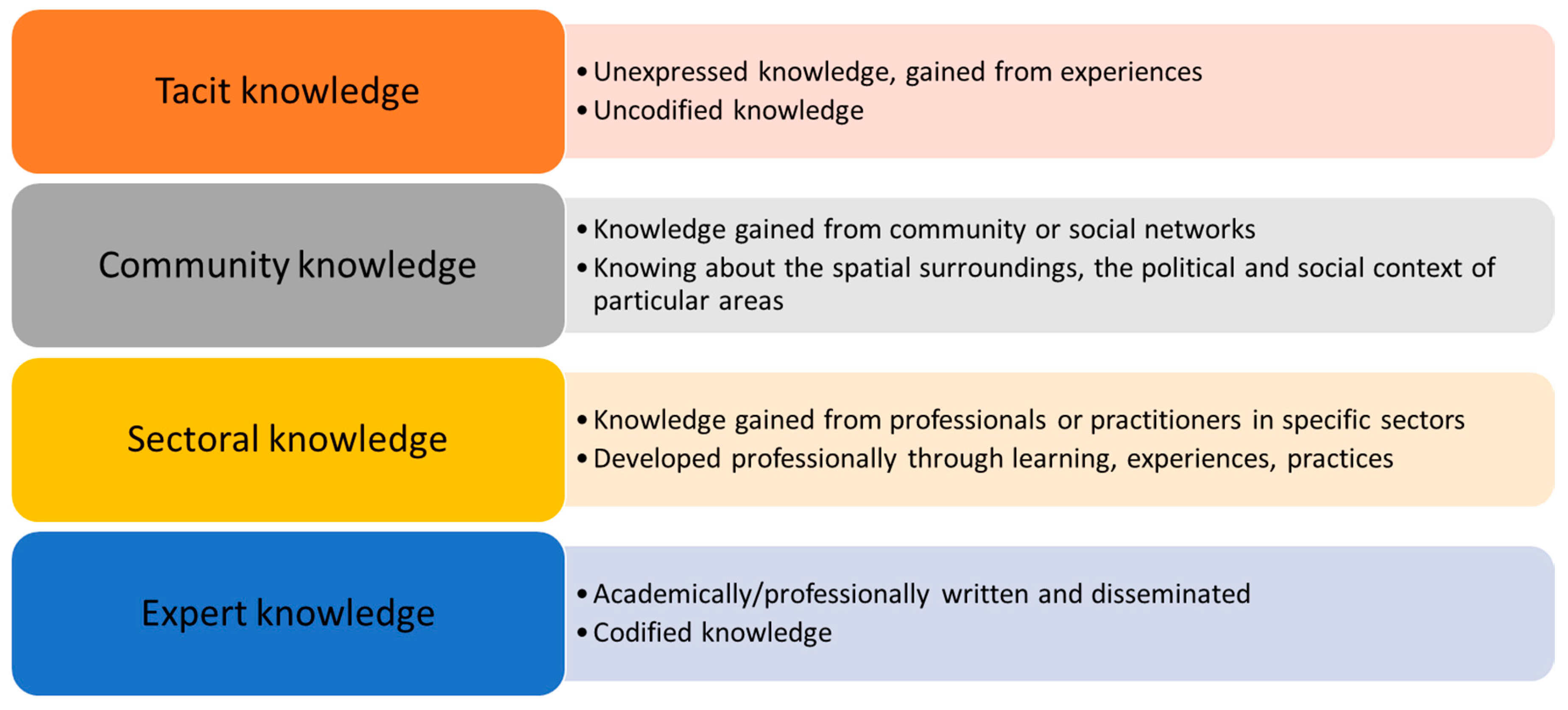
Figure 2.
Levels of spatial knowledge. Adapted from: Siegel and White (1975), Stern and Leiser (1988).
Figure 2.
Levels of spatial knowledge. Adapted from: Siegel and White (1975), Stern and Leiser (1988).
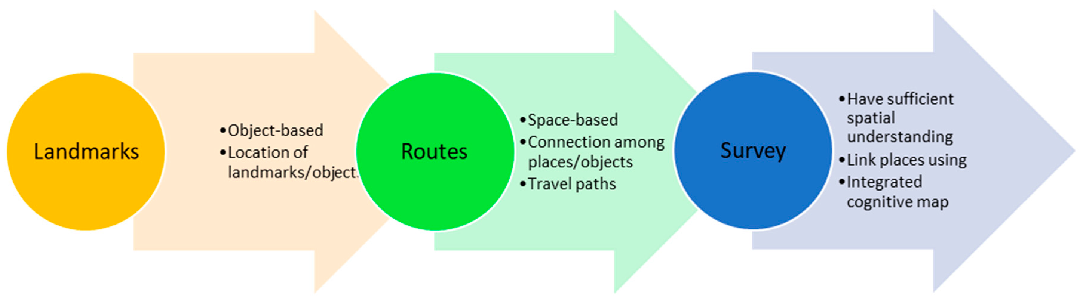
Figure 3.
Connection of spatial forms and social relations (types of socio-spatial relationships). Adapted from: Osti (2015).
Figure 3.
Connection of spatial forms and social relations (types of socio-spatial relationships). Adapted from: Osti (2015).

Figure 4.
The cube framework to understand the utilization of spatial knowledge. Adapted from: Pfeffer et al. (2013), Stern and Leiser (1988), Osti (2015).
Figure 4.
The cube framework to understand the utilization of spatial knowledge. Adapted from: Pfeffer et al. (2013), Stern and Leiser (1988), Osti (2015).

Figure 5.
A respondent in Kramat Gajah village drawing a sketch map (left); focus group discussion in Sidoharjo I Pasar Miring village (right).
Figure 5.
A respondent in Kramat Gajah village drawing a sketch map (left); focus group discussion in Sidoharjo I Pasar Miring village (right).
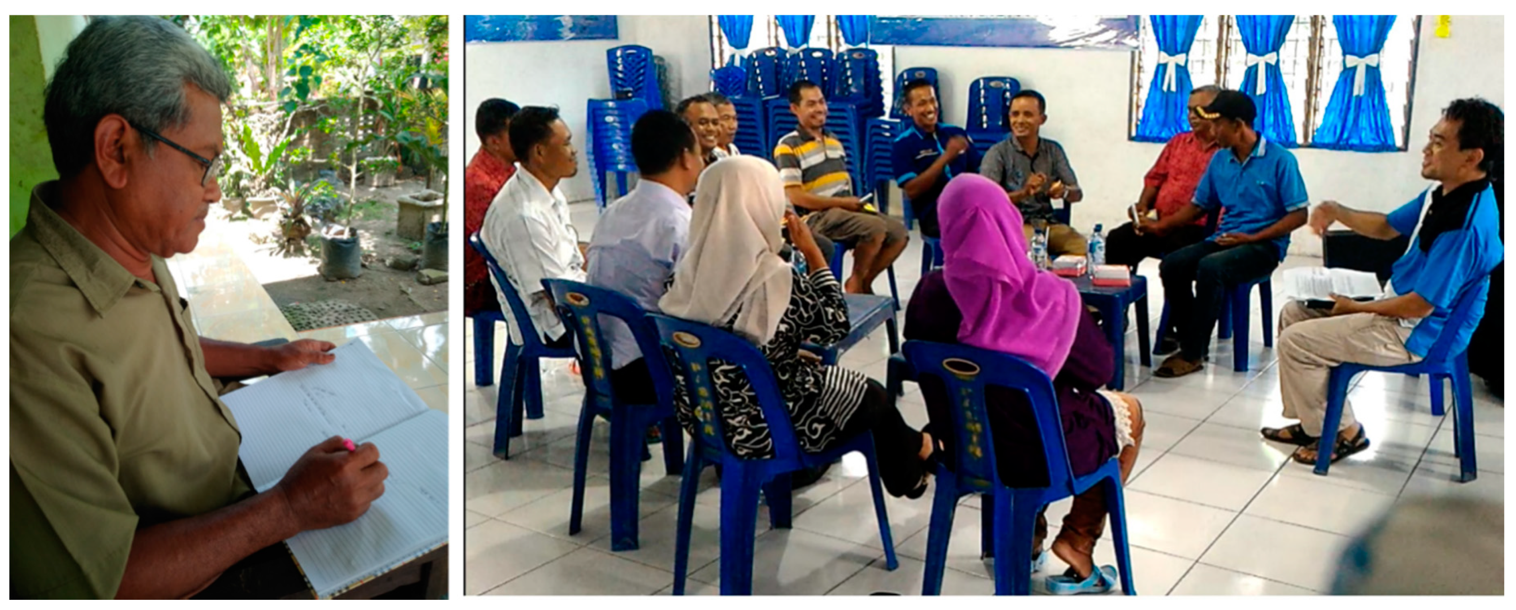
Figure 6.
Number of respondents in each stakeholder group with particular types of spatial knowledge (percentages in brackets).
Figure 6.
Number of respondents in each stakeholder group with particular types of spatial knowledge (percentages in brackets).
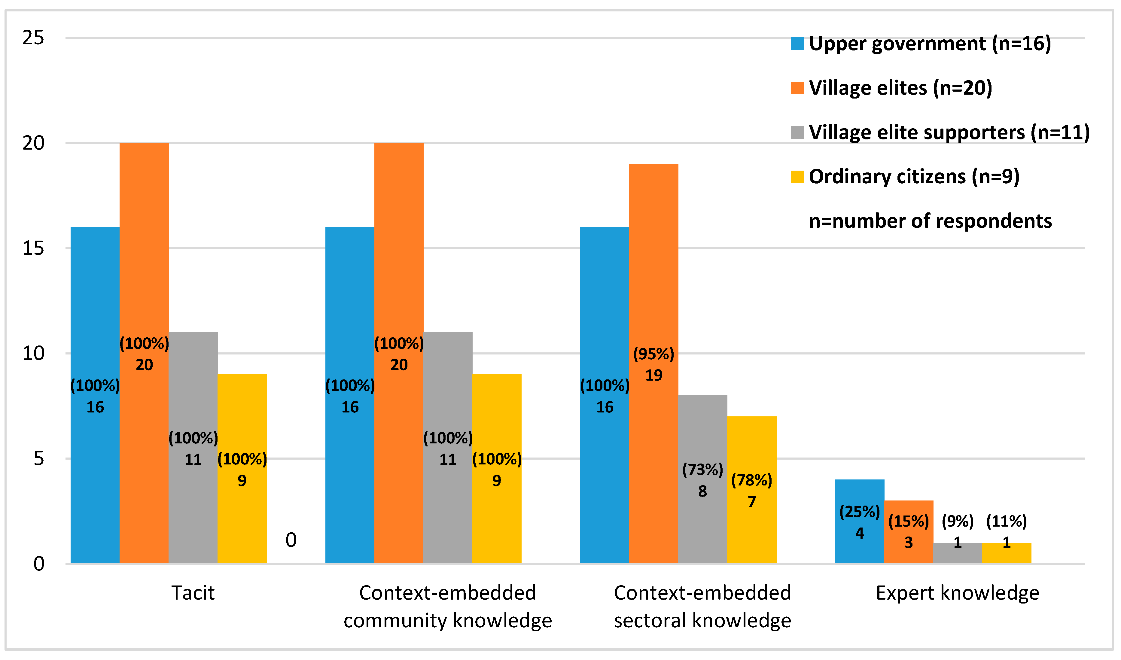
Figure 7.
Percentage of respondents in each stakeholder group who own a certain level of spatial knowledge (counts in brackets).
Figure 7.
Percentage of respondents in each stakeholder group who own a certain level of spatial knowledge (counts in brackets).
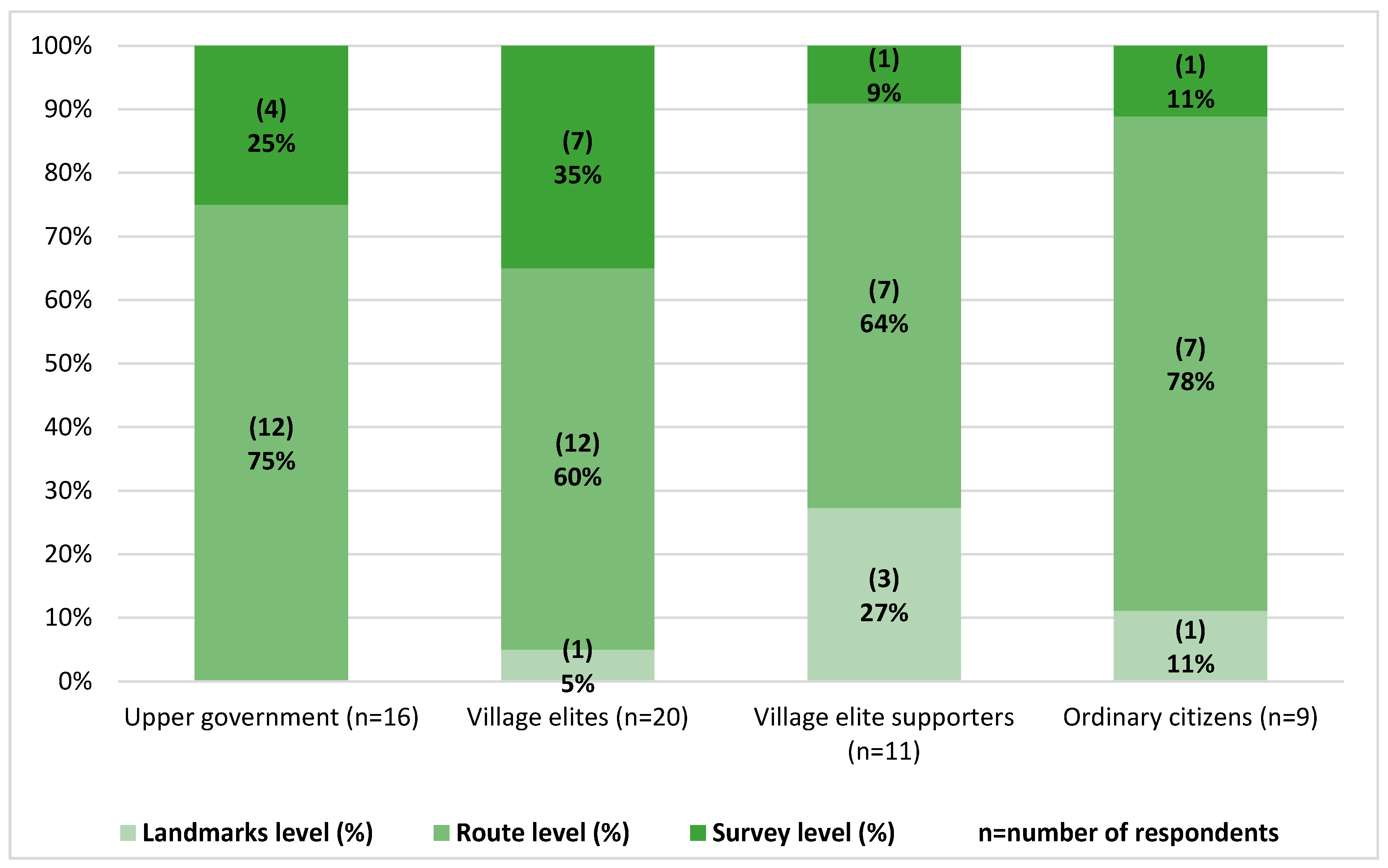
Figure 8.
Sketch map of Kolam village is hanged on the wall of the village office (left); map of neighbourhood XII in Kolam village, showing detailed information about the neighbourhood (social economy, facilities, housing, etc.) (right).
Figure 8.
Sketch map of Kolam village is hanged on the wall of the village office (left); map of neighbourhood XII in Kolam village, showing detailed information about the neighbourhood (social economy, facilities, housing, etc.) (right).

Figure 9.
Percentage of respondents in each stakeholder group who agree, partially agree, and do not agree with the potential use of maps in the Musrenbang practice (counts in brackets).
Figure 9.
Percentage of respondents in each stakeholder group who agree, partially agree, and do not agree with the potential use of maps in the Musrenbang practice (counts in brackets).
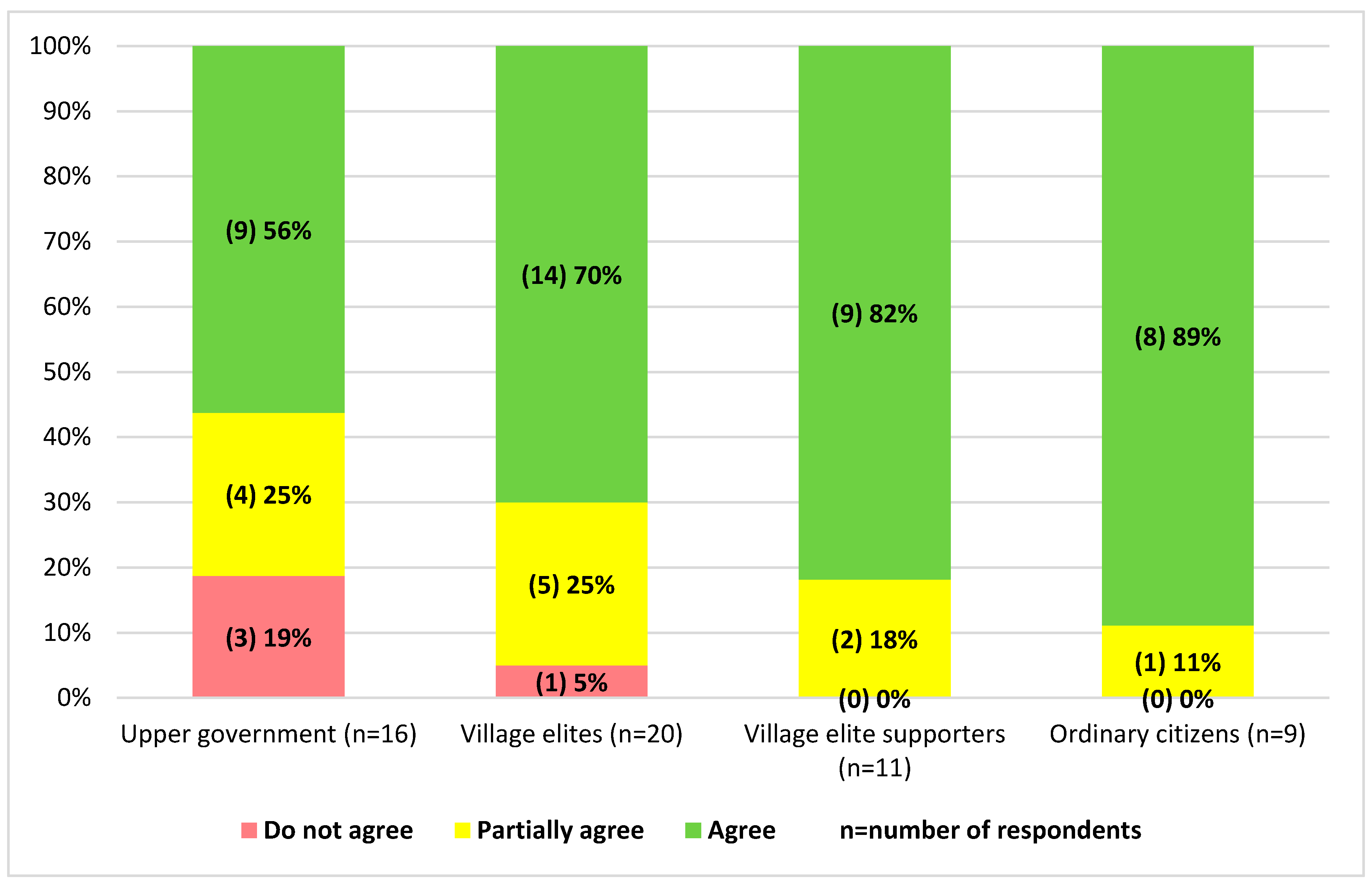
Figure 10.
Percentage of respondents in each stakeholder group who agree, partially agree, and do not agree to create maps through participatory mapping exercise (counts in brackets).
Figure 10.
Percentage of respondents in each stakeholder group who agree, partially agree, and do not agree to create maps through participatory mapping exercise (counts in brackets).
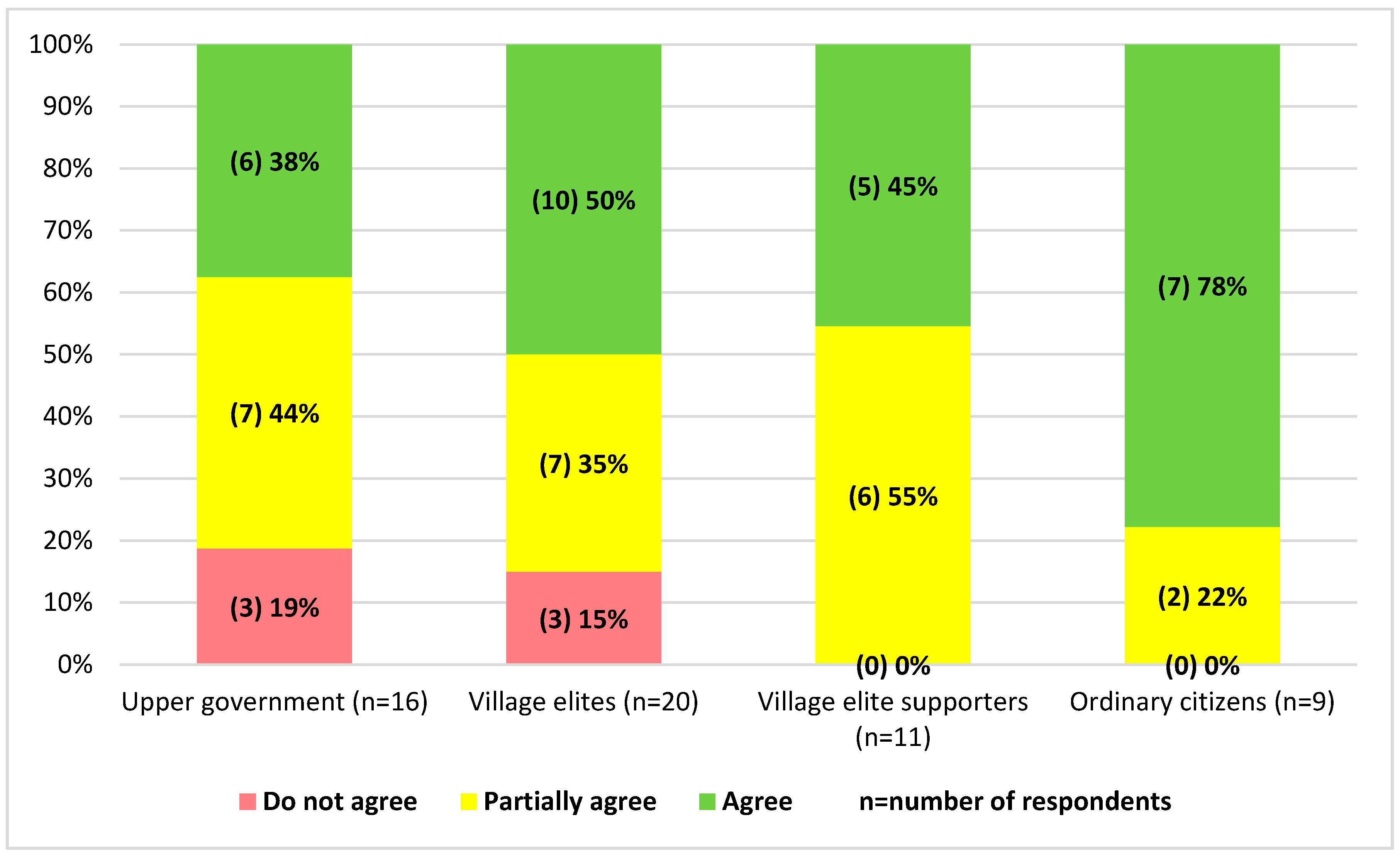
Table 1.
Criteria and means of verification of the types and levels of the participants/respondents’ spatial knowledge.
Table 1.
Criteria and means of verification of the types and levels of the participants/respondents’ spatial knowledge.
| Topic of Assessment | Means of Verification | Assessment Criteria (Characteristics) | References |
|---|---|---|---|
| Types of spatial knowledge | |||
| Observations, interviews, and group discussions |
| [8,24,41,42,43,44,45] |
| Observations, interviews, and group discussions |
| [8,24,41,42,43,44] |
| Observations, interviews, and group discussions |
| [8,24,41,42,43,44] |
| Observations, interviews, and group discussions |
| [8,24,41,42,43,44] |
| Levels of spatial knowledge | |||
| Interviews and group discussions |
| [29,34,46,47] |
| Interviews and group discussions |
| [29,34,46,47] |
|
| [29,34,46,47,48,49] |
Table 2.
Stakeholders interest and influence in utilizing spatial knowledge and spatial data in Musrenbang.
Table 2.
Stakeholders interest and influence in utilizing spatial knowledge and spatial data in Musrenbang.
| Stakeholder Groups | Impact | Interest | Influence | What is Important to the Stakeholder? | How could the Stakeholder Contribute to the Practice? | How Could the Stakeholder Block the Practice? |
|---|---|---|---|---|---|---|
| Upper government | Low | Low | High | Codified spatial knowledge is useful to support planning practices as well as to formulate development planning documents | Providing spatial data at the district, sub-district, and village level | Lack of knowledge on how to produce reliable and accurate spatial data |
| Village elites | High | High | High | Spatial knowledge is useful to identify areas that need improvements | Utilizing spatial knowledge and spatial data to: (1) Better conceptualize development plans; (2) stimulate the discussions among Musrenbang participants | (1) Lack of knowledge about how to produce and use reliable and accurate spatial data; (2) show hesitation to use spatial data in the Musrenbang |
| Village elite supporters | Medium | Medium | Medium | Spatial knowledge is useful to identify areas that need improvements | Utilizing spatial knowledge and spatial data to better conceptualize development plans | Lack of knowledge about how to produce and use spatial data |
| Ordinary citizens | High | High | Low | Spatial knowledge is useful to understand the distribution of village development projects | Use their spatial knowledge supported by sufficient spatial data to enrich the discussion of village development plans. | Lack of knowledge on how to use spatial data effectively |
© 2020 by the authors. Licensee MDPI, Basel, Switzerland. This article is an open access article distributed under the terms and conditions of the Creative Commons Attribution (CC BY) license (http://creativecommons.org/licenses/by/4.0/).
Share and Cite
MDPI and ACS Style
Akbar, A.; Flacke, J.; Martinez, J.; van Maarseveen, M.F.A.M. Spatial Knowledge: A Potential to Enhance Public Participation? Sustainability 2020, 12, 5025. https://doi.org/10.3390/su12125025
AMA Style
Akbar A, Flacke J, Martinez J, van Maarseveen MFAM. Spatial Knowledge: A Potential to Enhance Public Participation? Sustainability. 2020; 12(12):5025. https://doi.org/10.3390/su12125025
Chicago/Turabian StyleAkbar, Aulia, Johannes Flacke, Javier Martinez, and Martin F.A.M. van Maarseveen. 2020. "Spatial Knowledge: A Potential to Enhance Public Participation?" Sustainability 12, no. 12: 5025. https://doi.org/10.3390/su12125025
Note that from the first issue of 2016, this journal uses article numbers instead of page numbers. See further details here.