Spatial Knowledge: A Potential to Enhance Public Participation?


Abstract
1. Introduction
2. The Relevance of Spatial Knowledge for Public Participation
2.1. Challenges in Public Participation
2.2. Spatial Knowledge
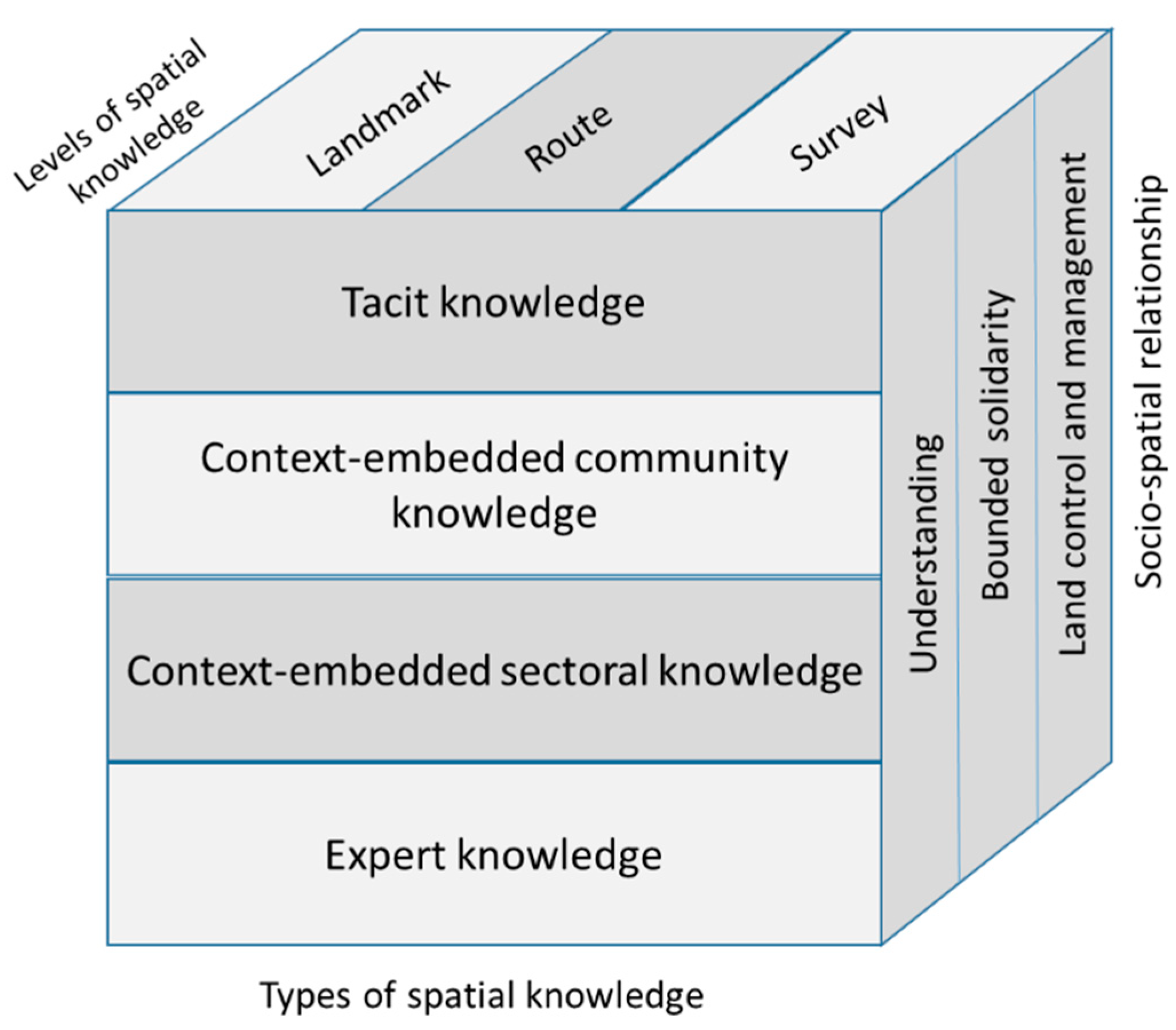
2.2.1. Types of Spatial Knowledge
2.2.2. Levels of Spatial Knowledge
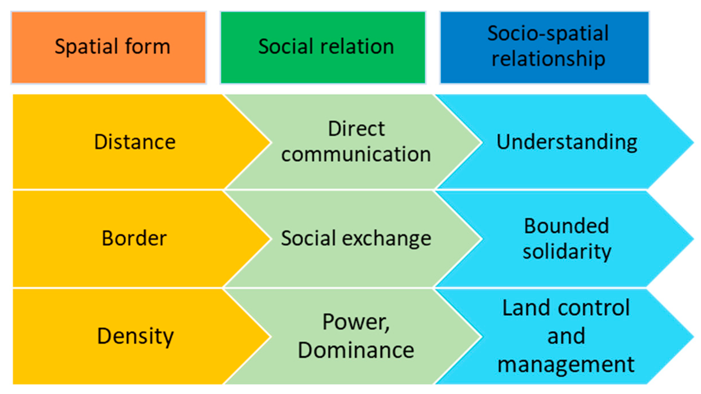
2.2.3. Socio-Spatial Relationships
“Social space is a distribution of such items (objects, places, settings, action-governing factors, and causal transactions) among places and paths, which automatically happens along with interrelated lives and which underlies both the objective dimensions of social spatiality and the construction of the built environment”.(Schatzki 1991: 667)
3. Material and Methods
3.1. The Case Study
3.2. A Framework to Examine Spatial Knowledge
3.3. Data Collection and Analysis
4. Results
4.1. Types, Levels of Spatial Knowledge, and Socio-Spatial Relationships of the Village Stakeholders
4.1.1. Types of Spatial Knowledge
“Yes, they [the participants] have it [spatial knowledge]. It is because they often go there or pass by the area. I suppose that they know how many turns [to reach a specific place in the village], how many holes, where are the location of the mosque and the houses nearby the mosque they also know”.(D1, personal communication, 6 March 2018)
4.1.2. Levels of Spatial Knowledge
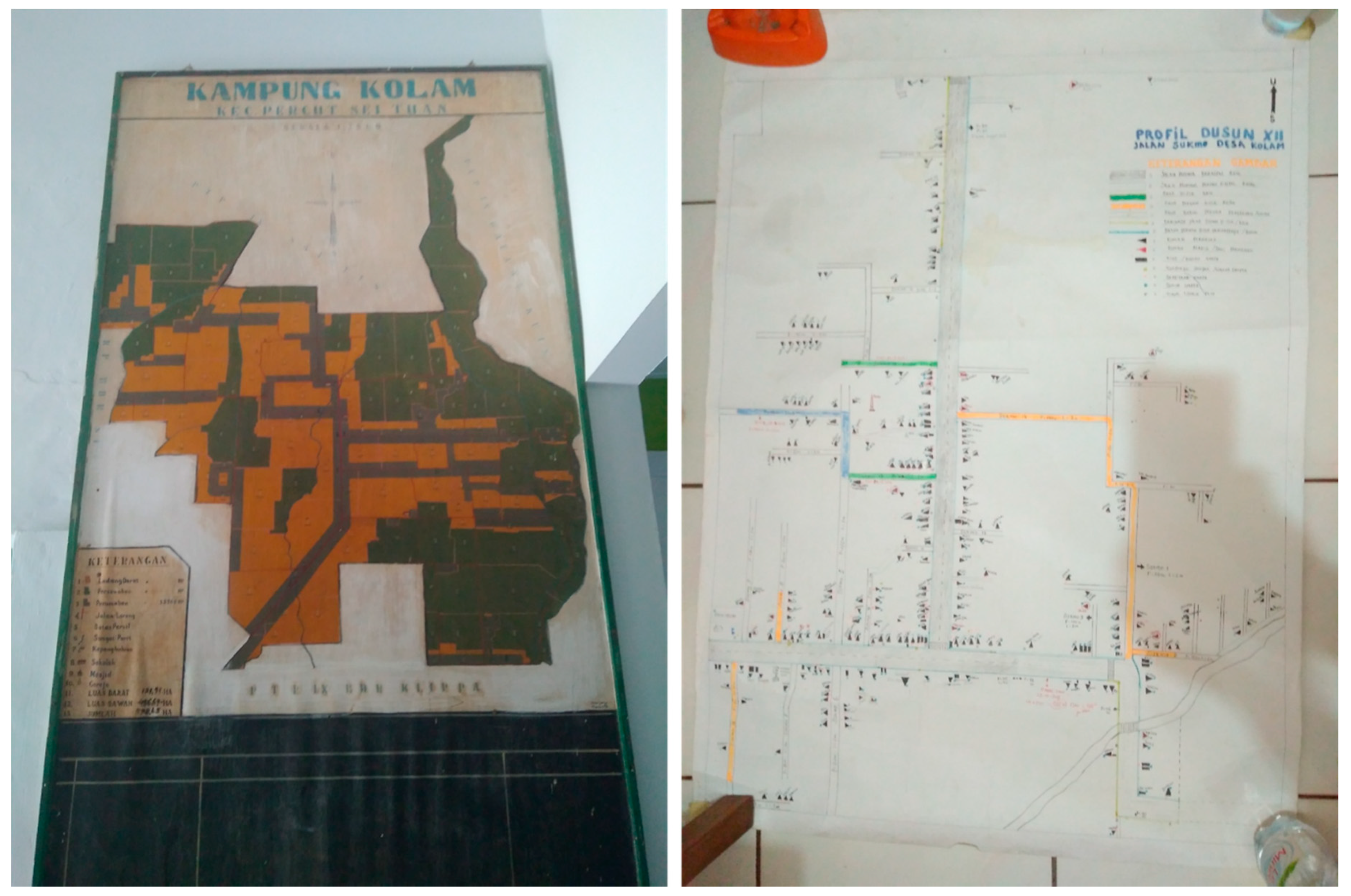
“We know about every place in this village, as we have traveled or passed by most of the areas. For example, if we want to go to Neighborhood 1, after passing by the village head office, we will find a T-junction. If we turn right, we are heading to Neighborhood 3. If we turn left, we are heading to Neighborhood 1, and it will end up at the village border, which is the Denai Sarang Burung village, our neighbor village”.(A1, personal communication, 1 March 2018)
“This is Mawar Street, this is Balai Desa Street. This is the road heading to Neighborhood 4. If we go North, we will get Neighborhood 3, then this is the [village] border. This is the rice mill”.(A6, personal communication, 1 March 2018)
4.1.3. Socio-Spatial Relationships of the Village Stakeholders
“So, from Denai Sarang Burung [village neighbor], this is the village border. We are going straight. Only the main roads, right? We will pass a mosque, then we simply follow the roads, we find a junction, we turn right to the village head office, passing the office, then we turn right, go straight follow the road heading here, so here we are”.(A5, personal communication, 8 March 2018)
4.2. Use of Spatial Knowledge and Geospatial Data in the Musrenbang
“When a participant said that they need to build an asphalt road in a specific area, we can visualize that area in our mind instinctively as we have traveled to that area a couple of times and we know the road condition is severe. So, the project is urgent. Yes, I think spatial knowledge is used”.(B5, personal communication, 4 March 2018)
“They use (spatial) knowledge (in Musrenbang). Even though they do not know the exact length of the irrigation tunnel, they already know where the location of the flooding is. They know that it happens due to no tunnel being available to discharge the water. So, they used their [spatial] knowledge”.(A2, personal communication, 1 March 2018)
4.3. To what Extent do Spatial Knowledge and Geospatial data Support the Participatory Processes?
“For example, when someone said Masjid Street, our mind starts to think about where it is. Oh, it is at the village border. The border is around some kilometers away from here. So, it [the location] just comes up. When somebody talks about that place, we can simply imagine it. We do not see it physically, but we can see it through our minds”.(A9, personal communication, 8 March 2018)
5. Discussion
5.1. Spatial Knowledge is used in Musrenbang, but not Properly Used
5.2. Codifying Knowledge to Integrate the Local Spatial Knowledge and Support the Musrenbang Practice
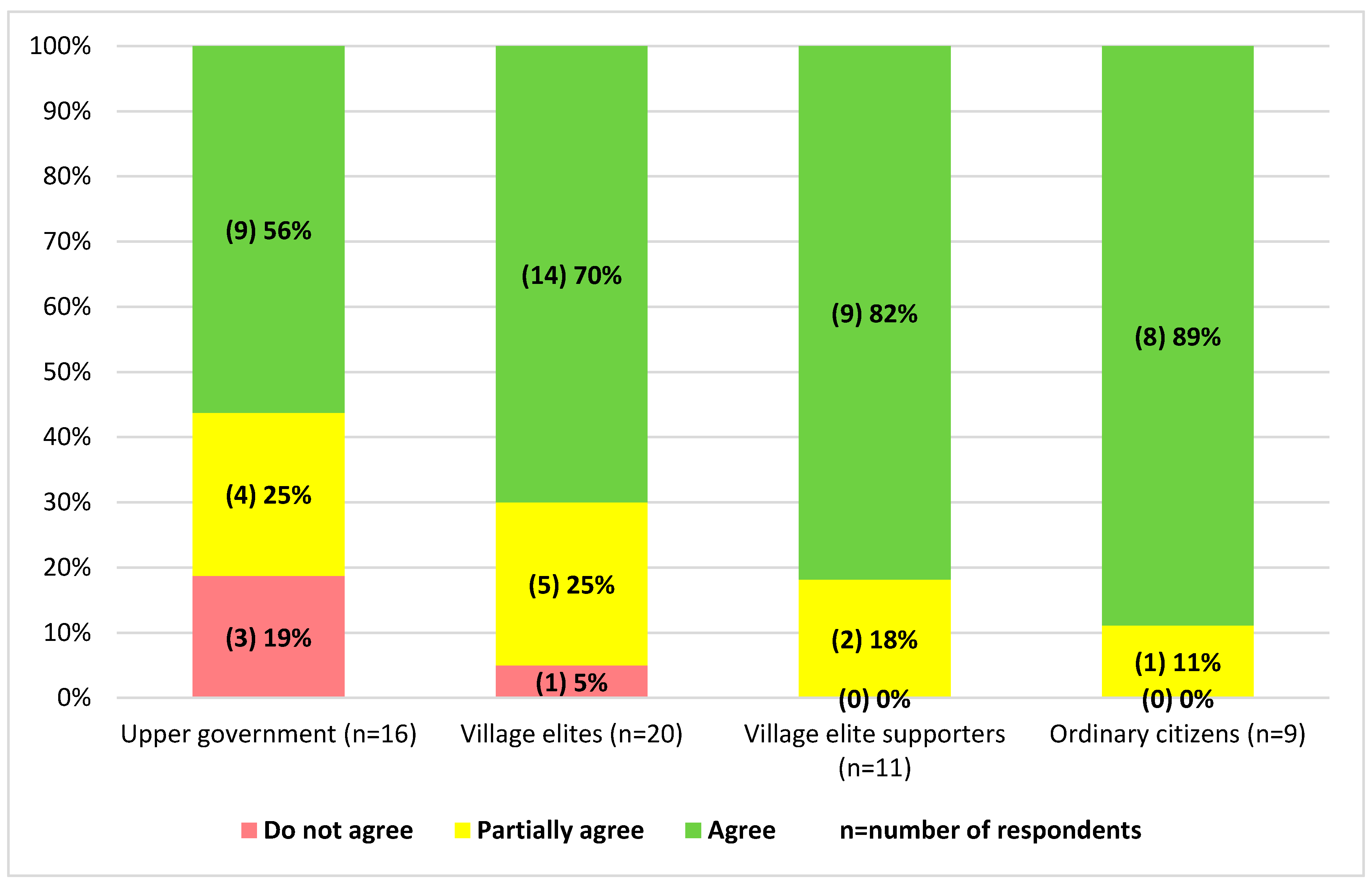
5.3. Willingness to Use Spatial Knowledge among Stakeholders of Musrenbang
6. Conclusions
Author Contributions
Funding
Acknowledgments
Conflicts of Interest
Appendix A
- How old are you?.......... old
- Sexa. Male b. Female
- Education level:a. SD b. SMP c. SMA/SMK d. Diploma e. S-1 f. S-2 g. S-3
- Races …………………………
- Please explain briefly what is your role in the Musrenbang? Representing which stakeholders?…………………………………………………………………………………………….
- The goal of the Musrenbang is clear for me.SA ☐ A ☐ U ☐ D ☐ SD ☐Comments:…………………………………………………………………………………………………………
- The Musrenbang process was made transparent for me.SA ☐ A ☐ U ☐ D ☐ SD ☐Comments:…………………………………………………………………………………………………………
- Rules of the Musrenbang were agreed in advance by the participants.SA ☐ A ☐ U ☐ D ☐ SD ☐Comments:…………………………………………………………………………………………………………
- I could identify the real problems faced by our villages in an integrated and comprehensive way.SA ☐ A ☐ U ☐ D ☐ SD ☐Please explain…………………………………………………………………………………………………………
- The participants invited to Musrenbang have represented all important stakeholders in the villageSA ☐ A ☐ U ☐ D ☐ SD ☐If not, who else should be involved?................................................................................................................………
- Each participant has the same opportunities to have a say at the meeting.SA ☐ A ☐ U ☐ D ☐ SD ☐If not, why?……………………………………………………………………………………………………….
- Certain individuals tend to dominate the deliberative processes.SA ☐ A ☐ U ☐ D ☐ SD ☐Who were more dominant?……………………………………………………………………………………………………….Who were less dominant?……………………………………………………………………………………………………….
- There were little opportunities to share knowledge among participants.SA ☐ A ☐ U ☐ D ☐ SD ☐Comments:………………………………………………………………………………………………………
- Different opinions were not integrated well in the discussion.SA ☐ A ☐ U ☐ D ☐ SD ☐Why? Please explain……………………………………………………………………………………………………….
- Decisions were not made through consensus of participants.SA ☐ A ☐ U ☐ D ☐ SD ☐Why? Please explain ………………………………………………………………………………..
- Data/information (i.e., maps, graphs, pictures, audio, etc.) to support the deliberative and decision making processes was not available.SA ☐ A ☐ U ☐ D ☐ SD ☐If available, what kind of data/information was provided?…………………………………………………………………………………………………………..If NOT available, what kind of data/information that should be available to support the process?…………………………………………………………………………………………………………..
- Data/information is needed to support the deliberative processes and decision making.SA ☐ A ☐ U ☐ D ☐ SD ☐Please explain…………………………………………………………………………………………………………..
- I learned nothing from other Musrenbang participants.SA ☐ A ☐ U ☐ D ☐ SD ☐Please explain………………………………………………………………………………………………………….
- Common understanding was built among participants.SA ☐ A ☐ U ☐ D ☐ SD ☐Please explain………………………………………………………………………………………………………….
- Budget allocation for public capital is still limited.SA ☐ A ☐ U ☐ D ☐ SD ☐Why? Please explain ………………………………………………………………………………….
Appendix B

| Attributes | Villages | |||||||||
|---|---|---|---|---|---|---|---|---|---|---|
| Denai Lama (n = 49) | Kolam (n = 56) | Kramat Gajah (n = 34) | Sidoharjo I Pasar Miring (n = 60) | Tandem Hulu II (n = 28) | ||||||
| Freq | % | Freq | % | Freq | % | Freq | % | Freq | % | |
| Age (year) | ||||||||||
| <21 | - | - | - | - | - | - | - | - | - | - |
| 21–30 | 7 | 17,9 | 3 | 5,5 | 3 | 9,7 | 1 | 2,3 | 1 | 4,0 |
| 31–40 | 13 | 33,3 | 9 | 16,4 | 8 | 25,8 | 10 | 22,7 | 7 | 28,0 |
| 41–50 | 16 | 41,0 | 33 | 60,0 | 14 | 45,2 | 18 | 40,9 | 13 | 52,0 |
| 51–60 | 3 | 7,7 | 5 | 9,1 | 4 | 12,9 | 12 | 27,3 | 4 | 16,0 |
| >60 | - | - | 5 | 9,1 | 2 | 6,5 | 3 | 6,8 | - | - |
| Sex | ||||||||||
| Male | 33 | 84,6 | 44 | 80,0 | 14 | 45,2 | 24 | 54,5 | 18 | 72,0 |
| Female | 6 | 15,4 | 11 | 20,0 | 17 | 54,8 | 20 | 45,5 | 7 | 28,0 |
| Education | ||||||||||
| SD (Elementary school) | 4 | 10,3 | 3 | 5,5 | - | - | 2 | 4,5 | - | - |
| SMP (Junior High School) | 9 | 23,1 | 13 | 23,6 | 12 | 38,7 | 10 | 22,7 | 1 | 4,0 |
| SMA (Senior High School) | 19 | 48,7 | 22 | 40,0 | 13 | 41,9 | 22 | 50,0 | 14 | 56,0 |
| Diploma | 1 | 2,6 | 4 | 7,3 | 2 | 6,5 | 3 | 6,8 | 2 | 8,0 |
| S1 (Bachelor) | 6 | 15,4 | 13 | 23,6 | 4 | 12,9 | 7 | 15,9 | 6 | 24,0 |
| S2 (Master) | - | - | - | - | - | - | - | - | 2 | 8,0 |
| Race | ||||||||||
| Javanese | 33 | 84,6 | 49 | 89,1 | 22 | 71,0 | 38 | 86,4 | 17 | 68,0 |
| Malay | 6 | 15,4 | 1 | 1,8 | - | - | 2 | 4,5 | 1 | 4,0 |
| Bataknese | - | - | 3 | 5,5 | 3 | 9,7 | 1 | 2,3 | - | - |
| Karonese | - | - | - | - | 1 | 3,2 | 1 | 2,3 | 4 | 16,0 |
| Sundanese | - | - | 1 | 1,8 | 4 | 12,9 | - | - | 1 | 4,0 |
| Mandailing | - | - | 1 | 1,8 | 1 | 3,2 | - | - | - | - |
| Tionghoa | - | - | - | - | - | - | - | - | 2 | 8,0 |
| Others | - | - | - | - | - | - | 2 | 4,5 | - | - |
| Total population (2016) | 2.764 | 16.753 | 2.104 | 5.292 | 8.773 | |||||
Appendix C
- 16.
- How was the discussion in Musrenbang?
- 17.
- Did the topic of discussion also mention particular places/locations within the village? Why?
- 18.
- When discussing specific places/locations, did you use any maps during the discussion? Did the Musrenbang organizers provide maps?
- 19.
- Did you receive any data/information from the Musrenbang organizer? Was it useful?
- 20.
- If yes, what kind of data/information did you get during the Musrenbang meeting?
- 21.
- If not, what kind of data/information do you think needs to be available for the Musrenbang meeting?
- 22.
- If the Musrenbang organizer gives you data/information, do you prefer to receive the data/information before or during the event? Why?
- 23.
- Do you think it is important to have data/information available for the Musrenbang meeting? Why?
- To what extent did you share your knowledge to other participants? Did other participants also share their knowledge?
- Do you think the participants effectively shared their knowledge to others? Why?
- Was a common understanding among stakeholders reached during the Musrenbang meeting?
- Was the discussion in the Musrenbang helpful for you to understand other participants’ point of view?
- Have you ever worked with maps? For what purpose did you work with maps?
- What kind of maps have you ever used?
- Can you understand the information shown on maps?
- Let me show you a map showing your village area (in digital format and analogue). Can you identify your neighbourhoods or living place? Can you point at some primary objects/places (such as village head office, mosque, etc.) in your village?
- Using this map (in digital format and analogue), do you know what the distance is between primary objects/places A and B? How can you measure the distance between A and B?
- In the field, do you know what the distance is between primary objects/places A and B? How can you measure the distance between A and B? Can we produce maps using the data between A and B? How can we draw the positions and the distances into maps?
- Do you know your village well? If I ask you a specific place in your village, can you imagine the place in your mind?
- Based on previous questions, it seems that you have spatial knowledge. This is a knowledge about space and place. Did you recognize it?
- Were discussions about name of places or geographical locations included in the deliberative processes of Musrenbang? How?
- Were the participants using their spatial knowledge that they have during the Musrenbang deliberative processes?
- To what extent did you use your spatial knowledge during the Musrenbang discussion?
- Does the village have maps? What kind of maps? How and when were the maps produced?
- Did you use the maps during the Musrenbang? How?
- Why did you use the maps during the Musrenbang?
- Did you use the maps for other development purposes out of Musrenbang?
- Did you know that based on the laws, each village must have village maps?
- Please draw the sketch map showing your village in this blank sheet. Can you do that?
- What is your opinion if we use maps during the Musrenbang meeting?
- What is your opinion if we involve each stakeholder who attended the Musrenbang to create the maps in a participatory manner?
- If you think it is possible, who are the stakeholders that need to be involved for the participatory mapping workshop? Why?
Appendix D
- Head of the village (Kepala Desa)
- Head of the village parliament board (Ketua BPD)
- Head of the village empowerment board (Ketua LPMD)
- Staff of the village office (Staf Kantor Desa) who is responsible to conduct the Musrenbang
- Head of the neighbourhood (Kepala Dusun)—2 people per village
- Head of the youth club (Ketua Karang Taruna)
- Head of the women club (Ketua PKK)
- Village companion (Pendamping Desa)
- Religious leaders
- Village prominent person
- Are you familiar with the Village Law?
- Can you tell us about the impact of the issuance of Village Law to the local governance processes?
- What are the impacts of the new law to the Musrenbang processes?
- Did you find that the current Musrenbang practices effective to discuss the plans? Why?
- What do you think that needs to be added to increase the effectiveness?
- What do you think about data availability? Is it important? Why?
- Do you think that sufficient data/information available could help the processes?
- Have you ever worked with a map? What kind of maps? For what purpose?
- Did you find it is useful to work with a map?
- What do you think if we also use maps in the Musrenbang processes?
- Are you aware that the new law obliges each village to have village maps?
- If I show you a satellite image, can you identify your point of interest in the village? (by showing a satellite image map with several points of interests).
- Do you think that the opinions and knowledge from the local people are necessary in the mapping processes? Why and how?
- Considering that each village must have village maps., do you prefer to produce the maps in a participatory way or just ‘given’ from the upper government? Why?
- If we would like to develop a participatory mapping methodology, which one do you prefer, drawing the maps in a digital or non-digital procedure?
- What things do you think need to be consider when developing the participatory mapping methodology?
- Do you think the workshop should be facilitated with a mapping expert? Why?
- Do we need to do site-visit when mapping? Why?
- Do you think that we can make use of the maps we have produced to improve the current Musrenbang practices? Why and how?
- Do you think that with the composition of the stakeholders involved would increase the effectiveness of the participatory mapping workshop?
- Do you think that the map making could enhance the communication and collaboration among stakeholders?
- Who are the stakeholders that you think have more power and influence in the processes? What ways do you think could minimize the power and influence imbalance? How?Thank you for your cooperation to participate participating in this focus group discussion.
Appendix E
| Level of Government Structure | Number of Interviewees | |
|---|---|---|
| Village level | Kolam | 8 |
| Sidoharjo I Pasar Miring | 8 | |
| Kramat Gajah | 8 | |
| Denai Lama | 9 | |
| Tandem Hulu II | 7 | |
| Sub-district level | Percut Sei Tuan | 3 |
| Pagar Merbau | 2 | |
| Galang | 3 | |
| Pantai Labu | 3 | |
| Hamparan Perak | 2 | |
| District level | Bappeda of Deli Serdang district | 1 |
| DPMD of Deli Serdang district | 1 | |
| Parliament Member (DPRD) of Deli Serdang district | 1 | |
| 56 |
References
- Rowe, G.; Frewer, L. A typology of public engagement mechanisms. Sci. Technol. Hum. Values 2005, 30, 251–290. [Google Scholar] [CrossRef]
- Mostert, E. The challenge of public participation. Water Policy 2003, 5, 179–197. [Google Scholar] [CrossRef]
- Fung, A. Putting the Public Back into Governance: Th e Challenges of Citizen Participation and Its Future. Public Adm. Rev. 2015, 75, 513–522. [Google Scholar] [CrossRef]
- Grillos, T. Participatory Budgeting and the Poor: Tracing Bias in a Multi-Staged Process in Solo, Indonesia. World Dev. 2017, 96, 343–358. [Google Scholar] [CrossRef]
- Antlöv, H. Village government and rural development in Indonesia: The new democratic framework. Bull. Indones. Econ. Stud. 2003, 39, 193–214. [Google Scholar] [CrossRef]
- Sopanah, A. Ceremonial Budgeting: Public Participation in Development Planning at an Indonesian Local Government Authority. J. Appl. Manag. Account. Res. 2012, 10, 73–84. [Google Scholar]
- Natarajan, L. Socio-spatial learning: A case study of community knowledge in participatory spatial planning. Prog. Plan. 2015, 111, 1–23. [Google Scholar] [CrossRef]
- Baud, I.; Pfeffer, K.; Scott, D.; Denis, E.; Sydenstricker, J. Participatory ‘Spatial’ Knowledge Management Configurations in Metropolitan Governance Networks for SD; EADI: Bonn, Germany, 2014. [Google Scholar]
- Pfeffer, K.; Martinez, J.; O’Sullivan, D.; Scott, D. Geo-technologies for spatial knowledge: Challenges for inclusive and sustainable urban development. In Geographies of Urban Governance; Gupta, J., Pfeffer, K., Verrest, H., Ros-Tonen, M., Eds.; Springer: Amsterdam, The Netherlands, 2015; pp. 147–173. [Google Scholar]
- Sieber, R.; Robinson, P.; Johnson, P.; Corbett, J. Doing public participation on the geospatial web. Ann. Am. Assoc. Geogr. 2016, 106, 1030–1046. [Google Scholar] [CrossRef]
- Elwood, S. Beyond cooptation or resistance: Urban spatial politics, community organizations, and GIS-based spatial narratives. Ann. Assoc. Am. Geogr. 2006, 96, 323–341. [Google Scholar] [CrossRef]
- Ghose, R. Community participation, spatial knowledge production, and GIS use in inner-city revitalization. J. Urban Technol. 2003, 10, 39–60. [Google Scholar] [CrossRef]
- Healey, P. Collaborative Planning: Shaping Places in Fragmented Societies; Macmillan: London, UK, 1997; ISBN 0 978-0-333-49574-2. [Google Scholar]
- Feruglio, F.; Rifai, A. Participatory Budgeting in Indonesia: Past, Present and Future; Institute of Development Studies: Brighton, UK, 2017. [Google Scholar]
- Akbar, A.; Flacke, J.; Martinez, J.; van Maarseveen, M.F.A. Participatory Planning Practice in Rural Indonesia: A Sustainable Development Goals-based Evaluation. Community Dev. 2020. [Google Scholar] [CrossRef]
- Kahila-Tani, M.; Kytta, M.; Geertman, S. Does mapping improve public participation ? Exploring the pros and cons of using public participation GIS in urban planning practices. Landsc. Urban Plan. 2019, 186, 45–55. [Google Scholar] [CrossRef]
- Innes, J.; Booher, D. Planning with Complexity: An Introduction to Collaborative Rationality for Public Policy; Routledge: Oxfordshire, UK, 2010; ISBN 0203864301. [Google Scholar]
- Leino, H. Boundary Interaction in Emerging Scenes: Two Participatory Planning Cases from Finland. Plan. Theory Pract. 2012, 13, 383–396. [Google Scholar] [CrossRef]
- Yanow, D. Accessing Local Knowledge. In Deliberative Policy Analysis: Understanding Governance in the Network Society; Hajer, M., Wagenaar, H., Eds.; Cambridge University Press: Cambridge, Uk, 2003; pp. 228–246. [Google Scholar]
- Albrechts, L. The planning community reflects on enhancing public involvement. Views from academics and reflective practitioners. Plan. Theory Pract. 2002, 3, 331–347. [Google Scholar] [CrossRef]
- Quick, K.; Feldman, M. Distinguishing participation and inclusion. J. Plan. Educ. Res. 2011, 31, 272–290. [Google Scholar] [CrossRef]
- Healey, P. Collaborative Planning in a Stakeholder Society. Town Plan. Rev. 1998, 69, 1–21. [Google Scholar] [CrossRef]
- Eilola, S.; Fagerholm, N.; Mäki, S.; Khamis, M. Realization of participation and spatiality in participatory forest management—A policy—Practice analysis from Zanzibar, Tanzania. J. Environ. Plan. Manag. 2015, 58, 1242–1269. [Google Scholar] [CrossRef]
- Pfeffer, K.; Baud, I.; Denis, E.; Scott, D.; Sydenstricker-Neto, J. Participatory spatial knowledge management tools: Empowerment and upscaling or exclusion? Inf. Commun. Soc. 2013, 16, 258–285. [Google Scholar] [CrossRef]
- Kahila-Tani, M.; Broberg, A.; Kyttä, M. Let the Citizens Map—Public Participation GIS as a Planning Support System in the Helsinki Master Plan Process. Plan. Pract. Res. 2016, 31, 195–214. [Google Scholar] [CrossRef]
- Shrestha, R.; Flacke, J.; Martinez, J.; van Maarseveen, M. Interactive cumulative burden assessment: Engaging stakeholders in an adaptive, participatory and transdisciplinary approach. Int. J. Environ. Res. Public Health 2018, 15, 260. [Google Scholar] [CrossRef] [PubMed]
- Hernández, D. Qualitative Representation of Spatial Knowledge; Carbonell, J., Siekmann, J., Eds.; Springer-Verlag: Berlin/Heidelberg, Germany, 1994; ISBN 3540580581. [Google Scholar]
- Siegel, A.; White, S. The development of spatial representations of large-scale environments. Adv. Child Dev. Behav. 1975, 10, 9–55. [Google Scholar] [CrossRef] [PubMed]
- Stern, E.; Leiser, D. Levels of Spatial Knowledge and Urban Travel Modeling. Geogr. Anal. 1988, 20, 140–155. [Google Scholar] [CrossRef]
- Schweizer, K.; Herrmann, T.; Janzen, G.; Katz, S. The route direction effect and its constraints. In Spatial Cognition: An Interdisciplinary Approach to Representing and Processing Spatial Knowledge; Freksa, C., Habel, C., Wender, K., Eds.; Springer: Berlin/Heidelberg, Germany, 1998; pp. 19–38. ISBN 3540646035. [Google Scholar]
- Richardson, A.; Montello, D.; Hegarty, M. Spatial knowledge acquisition from maps and from navigation in real and virtual environments. Mem. Cogn. 1999, 27, 741–750. [Google Scholar] [CrossRef] [PubMed]
- Montello, D. A new framework for understanding the acquisition of spatial knowledge in large-scale environments. In Spatial and Temporal Reasoning in Geographic Information Systems; Egenhofer, M., Golledge, R., Eds.; Oxford University Press: New York, NY, USA, 1998; pp. 143–154. [Google Scholar]
- Yeap, W.; Jefferies, M. On early cognitive mapping. Spat. Cogn. Comput. 2000, 2, 85–116. [Google Scholar] [CrossRef]
- Ishikawa, T.; Montello, D. Spatial knowledge acquisition from direct experience in the environment: Individual differences in the development of metric knowledge and the integration of separately learned places. Cogn. Psychol. 2006, 52, 93–129. [Google Scholar] [CrossRef]
- Kirschner, P.A.; Sweller, J.; Kirschner, F.; Zambrano, J.R. From Cognitive Load Theory to Collaborative Cognitive Load Theory. Int. J. Comput. Support. Collab. Learn. 2018, 13, 213–233. [Google Scholar] [CrossRef]
- Osti, G. Socio-spatial relations: An attempt to move space near society. Poliarchie. Stud. E Ric. Del Dispes 2015, 4, 6–24. [Google Scholar]
- Schatzki, T.R. Spatial Ontology and Explanation. Ann. Assoc. Am. Geogr. 1991, 81, 650–670. [Google Scholar] [CrossRef]
- Jessop, B.; Brenner, N.; Jones, M. Theorizing sociospatial relations. Environ. Plan. D Soc. Sp. 2008, 26, 389–401. [Google Scholar] [CrossRef]
- Murphy, J. The Challenge of Upgrading in African Industries: Socio-Spatial Factors and the Urban Environment in Mwanza, Tanzania. World Dev. 2007, 35, 1754–1778. [Google Scholar] [CrossRef]
- Daskalaki, M. Alternative organizing in times of crisis: Resistance assemblages and socio-spatial solidarity. Eur. Urban Reg. Stud. 2018, 25, 155–170. [Google Scholar] [CrossRef]
- Hordijk, M.; Sara, L.; Sutherland, C.; Scott, D. Participatory instruments and practices in urban governance. In Geographies of Urban Governance; Gupta, J., Pfeffer, K., Verrest, H., Ros-Tonen, M., Eds.; Springer: Cham, Switzerland, 2015; pp. 127–146. ISBN 978-3-319-21272-2. [Google Scholar] [CrossRef]
- Baud, I.; Pfeffer, K.; Sydenstricker, J.; Scott, D. Developing Participatory ‘Spatial’ Knowledge Models in Metropolitan Governance Networks for Sustainable Development: Literature Review; EADI: Bonn, Germany, 2011. [Google Scholar]
- Baud, I.; Scott, D.; Pfeffer, K.; Sydenstricker-Neto, J.; Denis, E. Reprint of: Digital and spatial knowledge management in urban governance: Emerging issues in India, Brazil, South Africa, and Peru. Habitat Int. 2015, 46, 225–233. [Google Scholar] [CrossRef]
- Martínez, J.; Pfeffer, K.; Baud, I. Factors shaping cartographic representations of inequalities. Maps as products and processes. Habitat Int. 2016, 51, 90–102. [Google Scholar] [CrossRef]
- Holden, M. Social learning in planning: Seattle’s sustainable development codebooks. Prog. Plann. 2008, 69, 1–40. [Google Scholar] [CrossRef]
- Lokka, I.; Çöltekin, A. Perspective switch and spatial knowledge acquisition: Effects of age, mental rotation ability and visuospatial memory capacity on route learning in virtual environments with different levels of realism. Cartogr. Geogr. Inf. Sci. 2020, 47, 14–27. [Google Scholar] [CrossRef]
- Teghil, A.; Boccia, M.; Bonavita, A.; Guariglia, C. Temporal features of spatial knowledge: Representing order and duration of topographical information. Behav. Brain Res. 2019, 376, 112218. [Google Scholar] [CrossRef]
- Bednarz, S.W.; Acheson, G. Maps and map learning in social studies. Soc. Educ. 2006, 70, 398. [Google Scholar]
- Hakan, K.; Demir, S. Developing Valid and Reliable Map Literacy Scale. Rev. Int. Geogr. Educ. Online 2014, 4, 120–137. [Google Scholar]
- Raum, S. A framework for integrating systematic stakeholder analysis in ecosystem services research: Stakeholder mapping for forest ecosystem services in the UK. Ecosyst. Serv. 2018, 29, 170–184. [Google Scholar] [CrossRef]
- Reed, M.; Graves, A.; Dandy, N.; Posthumus, H.; Hubacek, K.; Morris, J.; Prell, C.; Quinn, C.; Stringer, L. Who’s in and why? A typology of stakeholder analysis methods for natural resource management. J. Environ. Manag. 2009, 90, 1933–1949. [Google Scholar] [CrossRef] [PubMed]
- Bryman, A. Social Research Methods, 4th ed.; Oxford University Press: New York, NY, USA, 2012; ISBN 978-0-19-958805-3. [Google Scholar]
- Yin, R.K. Case Study Research: Design and Methods, 3rd ed.; SAGE Publications: Thousand Oaks, CA, USA, 2003. [Google Scholar]
- Shrestha, R.; Köckler, H.; Flacke, J.; Martinez, J.; van Maarseveen, M. Interactive Knowledge Co-Production and Integration for Healthy Urban Development. Sustainability 2017, 9, 1945. [Google Scholar] [CrossRef]
- Eilola, S.; Käyhkö, N.; Ferdinands, A.; Fagerholm, N. Landscape and Urban Planning A bird’ s eye view of my village—Developing participatory geospatial methodology for local level land use planning in the Southern Highlands of Tanzania. Landsc. Urban Plan. 2019, 190, 1–12. [Google Scholar] [CrossRef]
- Innes, J.; Booher, D. Reframing public participation: Strategies for the 21st century. Plan. Theory Pract. 2004, 5, 419–436. [Google Scholar] [CrossRef]
- Perdana, A.; Ostermann, F. A Citizen Science Approach for Toponyms Collecting Toponyms. ISPRS Int. J. Geo Inf. 2018, 7, 222. [Google Scholar] [CrossRef]
- Perdana, A.; Ostermann, F. Eliciting Knowledge on Technical and Legal Aspects of Participatory Toponym Handling. ISPRS Int. J. Geo Inf. 2019, 8, 500. [Google Scholar] [CrossRef]
- Flacke, J.; Shrestha, R.; Aguilar, R. Strengthening participation using interactive planning support systems: A systematic review. ISPRS Int. J. Geo Inf. 2020, 9, 49. [Google Scholar] [CrossRef]
- Feng, L.; Wu, Q.; Wu, W.; Liao, W. Decision-Maker-Oriented VS. Collaboration: China’s Public Participation in Environmental Decision-Making. Sustainability 2020, 12, 1334. [Google Scholar] [CrossRef]
- Haselsberger, B. Decoding borders. Appreciating border impacts on space and people. Plan. Theory Pract. 2014, 15, 505–526. [Google Scholar] [CrossRef]
- Corbett, J.; Keller, C. Empowerment and Participatory Geographic Information and Multimedia Systems: Observations from Two Communities in Indonesia. Inf. Technol. Int. Dev. 2005, 2, 25–44. [Google Scholar] [CrossRef]
- Szyszka, M.; Polko, P. Interactive maps of social problems and security threats illustrated with an example of solutions currently used in Upper Silesia. Sustainability 2020, 12, 1229. [Google Scholar] [CrossRef]
- Haklay, M. How good is volunteered geographical information? A comparative study of OpenStreetMap and ordnance survey datasets. Environ. Plan. B Plan. Des. 2010, 37, 682–703. [Google Scholar] [CrossRef]
- Santos, L.; Coutinho-Rodrigues, J.; Antunes, C. A web spatial decision support system for vehicle routing using Google Maps. Decis. Support Syst. 2011, 51, 1–9. [Google Scholar] [CrossRef]
- Curşeu, P.; Schruijer, S. Participation and goal achievement of multiparty collaborative systems dealing with complex problems: A natural experiment. Sustainability 2020, 12, 987. [Google Scholar] [CrossRef]
- Aguilar, R.; Flacke, J.; Pfeffer, K. Towards supporting collaborative spatial planning: Conceptualization of a maptable tool through user stories. ISPRS Int. J. Geo Inf. 2020, 9, 29. [Google Scholar] [CrossRef]
- Warburton, E. Jokowi and the New Developmentalism. Bull. Indones. Econ. Stud. 2016, 52, 297–320. [Google Scholar] [CrossRef]
- McCall, M.; Dunn, C. Geo-information tools for participatory spatial planning: Fulfilling the criteria for ‘good’ governance? Geoforum 2012, 43, 81–94. [Google Scholar] [CrossRef]
- Bovaird, T.; Loeffler, E. From Engagement to Co-production: The Contribution of Users and Communities to Outcomes and Public Value. Volunt. Int. J. Volunt. Nonprofit Organ. 2012, 23, 1119–1138. [Google Scholar] [CrossRef]
- Corbett, J.; Rambaldi, G.; Kyem, P.; Weiner, D.; Olson, R.; Muchemi, J.; McCall, M.; Chambers, R. Overview: Mapping for change—The emergence of a new practice. In Participatory Learning and Action 54, 13–19; IIED: London, UK, 2006. [Google Scholar]
- Wästberg, B.; Billger, M.; Adelfio, M. A user-based look at visualization tools for environmental data and suggestions for improvement-an inventory among city planners in gothenburg. Sustainability 2020, 12, 2882. [Google Scholar] [CrossRef]


| Topic of Assessment | Means of Verification | Assessment Criteria (Characteristics) | References |
|---|---|---|---|
| Types of spatial knowledge | |||
| Observations, interviews, and group discussions |
| [8,24,41,42,43,44,45] |
| Observations, interviews, and group discussions |
| [8,24,41,42,43,44] |
| Observations, interviews, and group discussions |
| [8,24,41,42,43,44] |
| Observations, interviews, and group discussions |
| [8,24,41,42,43,44] |
| Levels of spatial knowledge | |||
| Interviews and group discussions |
| [29,34,46,47] |
| Interviews and group discussions |
| [29,34,46,47] |
|
| [29,34,46,47,48,49] |
| Stakeholder Groups | Impact | Interest | Influence | What is Important to the Stakeholder? | How could the Stakeholder Contribute to the Practice? | How Could the Stakeholder Block the Practice? |
|---|---|---|---|---|---|---|
| Upper government | Low | Low | High | Codified spatial knowledge is useful to support planning practices as well as to formulate development planning documents | Providing spatial data at the district, sub-district, and village level | Lack of knowledge on how to produce reliable and accurate spatial data |
| Village elites | High | High | High | Spatial knowledge is useful to identify areas that need improvements | Utilizing spatial knowledge and spatial data to: (1) Better conceptualize development plans; (2) stimulate the discussions among Musrenbang participants | (1) Lack of knowledge about how to produce and use reliable and accurate spatial data; (2) show hesitation to use spatial data in the Musrenbang |
| Village elite supporters | Medium | Medium | Medium | Spatial knowledge is useful to identify areas that need improvements | Utilizing spatial knowledge and spatial data to better conceptualize development plans | Lack of knowledge about how to produce and use spatial data |
| Ordinary citizens | High | High | Low | Spatial knowledge is useful to understand the distribution of village development projects | Use their spatial knowledge supported by sufficient spatial data to enrich the discussion of village development plans. | Lack of knowledge on how to use spatial data effectively |
© 2020 by the authors. Licensee MDPI, Basel, Switzerland. This article is an open access article distributed under the terms and conditions of the Creative Commons Attribution (CC BY) license (http://creativecommons.org/licenses/by/4.0/).
Share and Cite
Akbar, A.; Flacke, J.; Martinez, J.; van Maarseveen, M.F.A.M. Spatial Knowledge: A Potential to Enhance Public Participation? Sustainability 2020, 12, 5025. https://doi.org/10.3390/su12125025
Akbar A, Flacke J, Martinez J, van Maarseveen MFAM. Spatial Knowledge: A Potential to Enhance Public Participation? Sustainability. 2020; 12(12):5025. https://doi.org/10.3390/su12125025
Chicago/Turabian StyleAkbar, Aulia, Johannes Flacke, Javier Martinez, and Martin F.A.M. van Maarseveen. 2020. "Spatial Knowledge: A Potential to Enhance Public Participation?" Sustainability 12, no. 12: 5025. https://doi.org/10.3390/su12125025
APA StyleAkbar, A., Flacke, J., Martinez, J., & van Maarseveen, M. F. A. M. (2020). Spatial Knowledge: A Potential to Enhance Public Participation? Sustainability, 12(12), 5025. https://doi.org/10.3390/su12125025