Revised SEDD (RSEDD) Model for Sediment Delivery Processes at the Basin Scale


Abstract
1. Introduction
1.1. SEDD Model
1.2. Incorrect Assertions of SEDD
- (a)
- “the Sediment Delivery Ratio, SDRi, of each morphological area is a measurement of the probability that the eroded particles arrive from the considered area into the nearest stream reach” [9];
- (b)
- the SDRi equation is an exponential distribution (exponential probability distribution);
- (c)
- (d)
- “the probability that the eroded particles arrive from the morphological unit into the nearest stream reach is assumed proportional to the probability of non-exceedance of the travel time, tp,i ” [9];
- (e)
- the β coefficient can be lumped together with “the effects due to roughness and runoff along the hydraulic path” [8];
- (f)
- the Fi is a CDF of the travel time represented by Equation (2).
2. Analysis
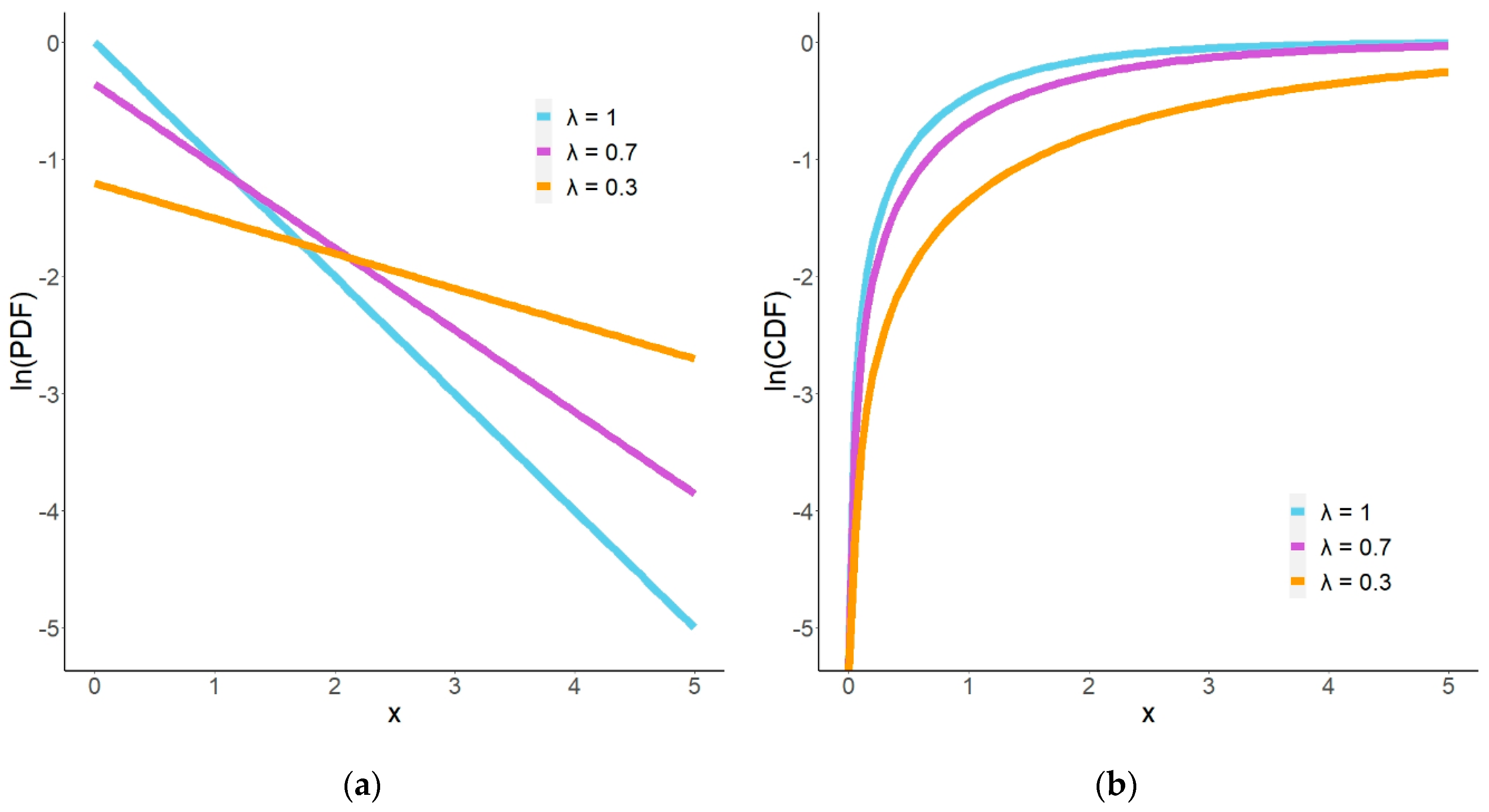
2.1. Properties of Exponential Distributions
2.2. Examination of SEDD Assertions
2.3. RSEDD Model
3. Example Watershed
4. Discussion
5. Summary and Conclusions
Author Contributions
Funding
Acknowledgments
Conflicts of Interest
References
- Van Oost, K.; Govers, G.; Desmet, P. Evaluating the effects of changes in landscape structure on soil erosion by water and tillage. Landsc. Ecol. 2000, 15, 577–589. [Google Scholar] [CrossRef]
- Van Rompaey, A.J.J.; Verstraeten, G.; Van Oost, K.; Govers, G.; Poesen, J. Modelling mean annual sediment yield using a distributed approach. Earth Surf. Proc. Landf. 2001, 26, 1221–1236. [Google Scholar] [CrossRef]
- Verstraeten, G.; Van Oost, K.; Van Rompaey, A.; Poesen, J.; Govers, G. Evaluating an integrated approach to catchment management to reduce soil loss and sediment pollution through modelling. Soil Use Manag. 2002, 18, 386–394. [Google Scholar] [CrossRef]
- Mitasova, H.; Hofierka, J.; Zlocha, M.; Iverson, L.R. Modeling topographic potential for erosion and deposition using GIS. Int. J. Geogr. Inf. Syst. 1996, 10, 629–641. [Google Scholar] [CrossRef]
- Mitas, L.; Mitasova, H. Distributed soil erosion simulation for effective erosion prevention. Water Resour. Res. 1998, 34, 505–516. [Google Scholar] [CrossRef]
- Mitasova, H.; Mitas, L. Multiscale soil erosion simulations for land use management. In Landscape Erosion and Landscape Evolution Modeling; Harmon, R., Doe, W.W., Eds.; Springer: New York, NY, USA, 2001; pp. 321–348. [Google Scholar]
- Warren, S.D.; Mitášová, H.; Hohmann, M.G.; Landsberger, S.; Iskander, F.Y.; Ruzycki, T.S.; Senseman, G.M. Validation of a 3-D enhancement of the Universal Soil Loss Equation for prediction of soil erosion and sediment deposition. Catena 2005, 64, 281–296. [Google Scholar] [CrossRef]
- Ferro, V.; Porto, P. Sediment delivery distributed (SEDD) model. J. Hydrol. Eng. 2000, 5, 411–422. [Google Scholar] [CrossRef]
- Ferro, V.; Minacapilli, M. Sediment delivery processes at basin scale. Hydrol. Sci. J. 1995, 40, 703–717. [Google Scholar] [CrossRef]
- Fernandez, C.; Wu, J.Q.; McCool, D.K.; Stöckle, C.O. Estimating water erosion and sediment yield with GIS, RUSLE, and SEDD. J. Soil Water Conserv. 2003, 58, 128–136. [Google Scholar]
- Fu, G.; Chen, S.; McCool, D.K. Modeling the impacts of no-till practice on soil erosion and sediment yield with RUSLE, SEDD, and ArcView GIS. Soil Tillage Res. 2006, 85, 38–49. [Google Scholar] [CrossRef]
- Tanyaş, H.; Kolat, Ç.; Süzen, M.L. A new approach to estimate cover-management factor of RUSLE and validation of RUSLE model in the watershed of Kartalkaya Dam. J. Hydrol. 2015, 528, 584–598. [Google Scholar] [CrossRef]
- Burguet, M.; Taguas, E.V.; Gómez, J.A. Exploring calibration strategies of the SEDD model in two olive orchard catchments. Geomorphology 2017, 290, 17–28. [Google Scholar] [CrossRef]
- Olii, M.R.; Kironoto, B.A.; Yulistiyanto, B.; Sunjoto, S. Estimating spatially distributed of sediment yield using GIS-RUSLE-SEDD model in catchment of reservoir in Java. In Multi-Perspective Water for Sustainable Development, Proceedings of the 21st International Association for Hydro-Environment Engineering and Research-Asia Pacific Division (IAHR-APD) Congress, Yohyakarta, Indonesia, 2–5 September 2018; IAHR-APD: Gyeonggi-Do, Korea, 2018; pp. 351–358. [Google Scholar]
- Neter, J.; Wasserman, W.; Whitmore, G.A. Applied Statistics, 4th ed.; Allyn and Bacon: Boston, MA, USA, 1993; pp. 153–155. [Google Scholar]
- Zhang, G.; Wang, Y.; Wei, H.; Chen, Y. Examining headway distribution models with urban freeway loop event data. Transp. Res. Rec. 2007, 1999, 141–149. [Google Scholar] [CrossRef]
- Proschan, F. Theoretical explanation of observed decreasing failure rate. Technometrics 2000, 42, 7–11. [Google Scholar] [CrossRef]
- McGuire, K.J.; McDonnell, J.J.; Weiler, M.; Kendall, C.; McGlynn, B.L.; Welker, J.M.; Seibert, J. The role of topography on catchment-scale water residence time. Water Resour. Res. 2005, 41, 1–14. [Google Scholar] [CrossRef]
- Shipley, B.; Vile, D.; Garnier, É. From plant traits to plant communities: A statistical mechanistic approach to biodiversity. Science 2006, 314, 812–814. [Google Scholar] [CrossRef] [PubMed]
- Morgan, R.P.C.; Quinton, J.N.; Smith, R.E.; Govers, G.; Poesen, J.W.A.; Auerswald, K.; Chisci, G.; Torri, D.; Styczen, M.E.; Folly, A.J.V. The European Soil Erosion Model (EUROSEM): Documentation and User Guide; Silsoe College, Cranfield University: Bedford, UK, 1998; pp. 35–36. [Google Scholar]
- Mendenhall, W.; Sincich, T. A Second Course in Business Statistics: Regression Analysis, 3rd ed.; Dellen Publishing Company: San Francisco, CA, USA, 1989; pp. 37–40. [Google Scholar]
- Ferro, V. Further remarks on a distributed approach to sediment delivery. Hydrol. Sci. J. 1997, 42, 633–647. [Google Scholar] [CrossRef]
- Ferro, V.; Porto, P.; Tusa, G. Testing a distributed approach for modelling sediment delivery. Hydrol. Sci. J. 1998, 43, 425–442. [Google Scholar] [CrossRef]
- Ferro, V.; Di Stefano, C.; Minacapilli, M.; Santoro, M. Calibrating the SEDD model for Sicilian ungauged basins. In Erosion Prediction in Ungauged Basins: Integrating Methods and Techniques, Proceedings of the Symposium HS01 Held During International Union of Geodesy and Geophysics (IUGG) 2003, Sapporo, Japan, 30 June–11 July 2003; IAHS-AISH Publication: Wallingford, Oxfordshire, UK, 2003; Volume 279, pp. 151–161. [Google Scholar]
- Di Stefano, C.; Ferro, V.; Minacapilli, M. Testing the SEDD model in Sicilian basins. In Sediment. Budgets 2, Proceedings of the Symposium S1 Held during the Seventh International Association of Hydrological Sciences (IAHS) Scientific Assembly, Foz do Iguaçu, Brazil, 3–9 April 2005; IAHS-AISH Publication: Wallingford, Oxfordshire, UK, 2005; Volume 292, pp. 152–161. [Google Scholar]
- Di Stefano, C.; Ferro, V. Testing the Modified Sediment Delivery Model (MOSEDD) at SPA2 Experimental Basin, Sicily (Italy). Land Degrad. Dev. 2017, 28, 1557–1567. [Google Scholar] [CrossRef]
- Di Stefano, C.; Ferro, V. Testing Sediment Connectivity at the Experimental SPA2 Basin, Sicily (Italy). Land Degrad. Dev. 2017, 28, 1992–2000. [Google Scholar] [CrossRef]
- Di Stefano, C.; Ferro, V. Modelling sediment delivery using connectivity components at the experimental SPA2 basin, Sicily (Italy). J. Mt. Sci. 2018, 15, 1868–1880. [Google Scholar] [CrossRef]
- Di Stefano, C.; Ferro, V. Assessing sediment connectivity in dendritic and parallel calanchi systems. Catena 2019, 172, 647–654. [Google Scholar] [CrossRef]
- Caraballo-Arias, N.A.; Di Stefano, C.; Ferro, V. Morphological characterization of calanchi (badland) hillslope connectivity. Land Degrad. Dev. 2018, 29, 1190–1197. [Google Scholar] [CrossRef]
- Yan, R.; Zhang, X.; Yan, S.; Chen, H. Estimating soil erosion response to land use/cover change in a catchment of the Loess Plateau, China. Int. Soil Water Conserv. Res. 2018, 6, 13–22. [Google Scholar] [CrossRef]
- Porto, P.; Cogliandro, V.; Callegari, G. Exploring the performance of the SEDD model to predict sediment yield in eucalyptus plantations. Long-term results from an experimental catchment in Southern Italy. In Institute of Physics (IOP) Conference Series: Earth and Environmental Science, Proceedings of the 3rd International Conference Environment and Sustainable Development of Territories: Ecological Challenges of the 21st Century, Kazan, Russia, 27–29 September 2017; IOP Publishing: Bristol, UK, 2018; Volume 107. [Google Scholar]
- Di Stefano, C.; Ferro, V.; Porto, P. Linking sediment yield and caesium-137 spatial distribution at basin scale. J. Agric. Eng. Res. 1999, 74, 41–62. [Google Scholar] [CrossRef]
- Di Stefano, C.; Ferro, V.; Rizzo, S. Assessing soil erosion in a small Sicilian basin by caesium-137 measurements and a simplified mass balance model. Hydrol. Sci. J. 2000, 45, 817–832. [Google Scholar] [CrossRef]
- He, Q.; Walling, D.E. Testing distributed soil erosion and sediment delivery models using 137Cs measurements. Hydrol. Proc. 2003, 17, 901–916. [Google Scholar] [CrossRef]
- Di Stefano, C.; Ferro, V.; Porto, P.; Rizzo, S. Testing a spatially distributed sediment delivery model (SEDD) in a forested basin by cesium-137 technique. J. Soil Water Conserv. 2005, 60, 148–157. [Google Scholar]
- Porto, P.; Walling, D.E. Use of caesium-137 measurements and long-term records of sediment load to calibrate the sediment delivery component of the SEDD model and explore scale effect: Examples from southern Italy. J. Hydrol. Eng. 2015, 20. [Google Scholar] [CrossRef]
- Di Stefano, C.; Ferro, V.; Porto, P. Modelling sediment delivery processes by a stream tube approach. Hydrol. Sci. 1999, 44, 725–742. [Google Scholar] [CrossRef]
- Di Stefano, C.; Ferro, V.; Porto, P. Length slope factors for applying the revised universal soil loss equation at basin scale in southern Italy. J. Agric. Eng. Res. 2000, 75, 349–364. [Google Scholar] [CrossRef][Green Version]
- Di Stefano, C.; Ferro, V.; Porto, P.; Tusa, G. Slope curvature influence on soil erosion and deposition processes. Water Resour. Res. 2000, 36, 607–617. [Google Scholar] [CrossRef]
- Zhao, Z.; Thien, L.C.; Yang, Q.; Rees, H.W.; Benoy, G.; Xing, Z.; Meng, F.-R. Model prediction of soil drainage classes based on digital elevation model parameters and soil attributes from coarse resolution soil maps. Can. J. Soil Sci. 2008, 88, 787–799. [Google Scholar] [CrossRef]
- Vigiak, O.; Borselli, L.; Newham, L.T.H.; McInnes, J.; Roberts, A.M. Comparison of conceptual landscape metrics to define hillslope-scale sediment delivery ratio. Geomorphology 2012, 138, 74–88. [Google Scholar] [CrossRef]
- Jain, M.K.; Kothyari, U.C. Estimation of soil erosion and sediment yield using GIS. Hydrol. Sci. 2000, 4, 771–786. [Google Scholar] [CrossRef]
- Son, K.I.; Lee, J.J. Prediction of erosion and deposition in a mountainous basin. In Sediment. Budgets 2, Proceedings of Symposium S1 Held during the Seventh International Association of Hydrological Sciences (IAHS) Scientific Assembly, Foz do Iguaçu, Brazil, 3–9 April 2005; IAHS-AISH Publication: Wallingford, Oxfordshire, UK, 2005; Volume 292, pp. 152–161, 185–193. [Google Scholar]
- Mutua, B.M.; Klik, A.; Loiskandl, W. Modelling soil erosion and sediment yield at a catchment scale: The case of Masinga catchment, Kenya. Land Degrad. Dev. 2006, 17, 557–570. [Google Scholar] [CrossRef]
- Di Stefano, C.; Ferro, V. Evaluation of the SEDD model for predicting sediment yield at the Sicilian experimental SPA2 basin. Earth Surf. Proc. Landf. 2007, 32, 1094–1109. [Google Scholar] [CrossRef]
- Bhattarai, R.; Dutta, D. Estimation of soil erosion and sediment yield using GIS at catchment scale. Water Resour. Manag. 2007, 21, 1635–1647. [Google Scholar] [CrossRef]
- Drzewiecki, W.; Mularz, S. Simulation of water soil erosion effects on sediment delivery to Dobczyce Reservoir. Int. Arch. Photogramm. Remote Sens. Spat. Inf. Sci.—ISPRS Arch. 2008, 37, 787–794. [Google Scholar]
- Vigiak, O.; Newham, L.T.H.; Whitford, J.; Melland, A.; Borselli, L. Comparison of landscape approaches to define spatial patterns of hillslope-scale sediment delivery ratio. In I14. Biophysical Modelling to Prioritise Catchment Management Effort, Proceedings of the 18th World IMACS Congress and MODSIM09 International Congress on Modelling and Simulation. Modelling and Simulation Society of Australia and New Zealand and International Association for Mathematics and Computers in Simulation, Cairns, Australia, 13–17 July 2009; Anderssen, R.S., Braddock, R.D., Newham, L.T.H., Eds.; Modelling and Simulation Society of Australia and New Zealand (MSSANZ): Canberra, Australia, 2009; pp. 4064–4070. [Google Scholar]
- Ali, K.F.; De Boer, D.H. Spatially distributed erosion and sediment yield modeling in the upper Indus River basin. Water Resour. Res. 2010, 46. [Google Scholar] [CrossRef]
- Chen, L.; Qian, X.; Shi, Y. Critical Area Identification of Potential Soil Loss in a Typical Watershed of the Three Gorges Reservoir Region. Water Resour. Manag. 2011, 25, 3445–3463. [Google Scholar] [CrossRef]
- Capra, A.; Ferro, V.; Porto, P.; Scicolone, B. Quantifying interrill and ephemeral gully erosion in a small Sicilian basin. Z. Geomorphol. 2012, 56 (Suppl. 1), 9–25. [Google Scholar] [CrossRef]
- Saygın, S.D.; Ozcan, A.U.; Basaran, M.; Timur, O.B.; Dolarslan, M.; Yılman, F.E.; Erpul, G. The combined RUSLE/SDR approach integrated with GIS and geostatistics to estimate annual sediment flux rates in the semi-arid catchment, Turkey. Environ. Earth Sci. 2014, 71, 1605–1618. [Google Scholar] [CrossRef]
- Lee, S.E.; Kang, S.H. Geographic information system-coupling sediment delivery distributed modeling based on observed data. Water Sci. Technol. 2014, 70, 495–501. [Google Scholar] [CrossRef] [PubMed]
- Kang, S.H. GIS-based sediment transport in Asian monsoon region. Environ. Earth Sci. 2014, 73, 221–230. [Google Scholar] [CrossRef]
- Pohlert, T. Projected climate change impact on soil erosion and sediment yield in the river Elbe catchment. In Sediment Matters; Heininger, P., Cullmann, J., Eds.; Springer International Publishing: Cham, Switzerland, 2015; pp. 97–108. [Google Scholar]
- Taguas, E.V.; Guzmán, E.; Guzmán, G.; Vanwalleghem, T.; Gómez, J.A. Characteristics and importance of rill and gully erosion: A case study in a small catchment of a marginal olive grove. Cuadernos Investigacion Geografica 2015, 41, 107–126. [Google Scholar] [CrossRef]
- Batista, P.V.G.; Silva, M.L.N.; Silva, B.P.C.; Curi, N.; Bueno, I.T.; Acérbi Júnior, F.W.; Davies, J.; Quinton, J. Modelling spatially distributed soil losses and sediment yield in the upper Grande River Basin—Brazil. Catena 2017, 157, 139–150. [Google Scholar] [CrossRef]
- Di Stefano, C.; Ferro, V.; Palazzolo, E.; Panno, M. Sediment delivery processes and agricultural non-point pollution in a Sicilian Basin. J. Agric. Eng. Res. 2000, 77, 103–112. [Google Scholar] [CrossRef]
- Di Stefano, C.; Ferro, V. Linking clay enrichment and sediment delivery processes. Biosyst. Eng. 2002, 81, 465–479. [Google Scholar] [CrossRef]
- Kothyari, U.C.; Jain, M.K.; Ranga Raju, K.G. Estimation of temporal variation of sediment yield using GIS. Hydrol. Sci. 2002, 47, 693–706. [Google Scholar] [CrossRef]
- Di Stefano, C.; Ferro, V.; Palazzolo, E.; Panno, M. Sediment delivery processes and chemical transport in a small forested basin. Hydrol. Sci. 2005, 50, 697–712. [Google Scholar] [CrossRef]
- Huang, J.; Li, Q.; Tu, Z.; Pan, C.; Zhang, L.; Ndokoye, P.; Lin, J.; Hong, H. Quantifying land-based pollutant loads in coastal area with sparse data: Methodology and application in China. Ocean Coast. Manag. 2013, 81, 14–28. [Google Scholar] [CrossRef]
- Di Piazza, G.V.; Di Stafano, C.; Ferro, V. Modelling the effects of a bushfire on erosion in a Mediterranean basin. Hydrol. Sci. 2007, 52, 1253–1270. [Google Scholar] [CrossRef]
- Kinsey-Henderson, A.E.; Post, D.A. Evaluation of the scale dependence of a spatially-explicit hillslope sediment delivery ratio model. In Proceedings of the 3rd International Congress on Environmental Modelling and Software (iEMSs), Burlington, VT, USA, 1 July 2006; BYU ScholarsArchive: Provo, UT, USA, 2006; p. 213. [Google Scholar]
- Post, D.A.; Kinsey-Henderson, A.E.; Bartley, R.; Hawdon, A. Deriving a spatially-explicit hillslope sediment delivery ratio model based on the travel time of water across a hillslope. In Proceedings of the 3rd International Congress on Environmental Modelling and Software (iEMSs), Burlington, VT, USA, 1 July 2006; BYU ScholarsArchive: Provo, UT, USA, 2006; p. 213. [Google Scholar]
- Zhao, Z.; Chow, T.L.; Rees, H.W.; Yang, Q.; Xing, Z.; Meng, F.-R. Predict soil texture distributions using an artificial neural network model. Comput. Electron. Agric. 2009, 65, 36–48. [Google Scholar] [CrossRef]
- López-Vicente, M.; Navas, A. Relating soil erosion and sediment yield to geomorphic features and erosion processes at the catchment scale in the Spanish Pre-Pyrenees. Environ. Earth Sci. 2010, 61, 143–158. [Google Scholar] [CrossRef]
- Tamene, L.; Le, Q.B.; Vlek, P.L.G. A Landscape Planning and Management Tool for Land and Water Resources Management: An Example Application in Northern Ethiopia. Water Resour. Manag. 2014, 28, 407–424. [Google Scholar] [CrossRef]
- Zhao, G.; Kondolf, G.M.; Mu, X.; Han, M.; He, Z.; Rubin, Z.; Wang, F.; Gao, P.; Sun, W. Sediment yield reduction associated with land use changes and check dams in a catchment of the Loess Plateau, China. Catena 2017, 148, 126–137. [Google Scholar] [CrossRef]
- Tamene, L.; Adimassu, Z.; Aynekulu, E.; Yaekob, T. Estimating landscape susceptibility to soil erosion using a GIS-based approach in Northern Ethiopia. Int. Soil Water Conserv. Res. 2017, 5, 221–230. [Google Scholar] [CrossRef]
- Xu, Y.; Tang, H.; Wang, B.; Chen, J. Effects of landscape patterns on soil erosion processes in a mountain–basin system in the North China. Nat. Hazard. 2017, 87, 1567–1585. [Google Scholar] [CrossRef]
- Walling, D.E.; He, Q. Use of fallout 137Cs measurements for validating and calibrating soil erosion and sediment delivery models. IAHS-AISH Publ. 1998, 249, 267–278. [Google Scholar]
- De Roo, A.P.J. Modelling runoff and sediment transport in catchments using GIS. Hydrol. Proc. 1998, 12, 905–922. [Google Scholar] [CrossRef]
- Di Stefano, C.; Ferro, V.; Porto, P. Applying the bootstrap technique for studying soil redistribution by caesium-137 measurements at basin scale. Hydrol. Sci. 2000, 45, 171–183. [Google Scholar] [CrossRef]
- Lu, X.X.; Higgitt, D.L. Sediment delivery to the Three Gorges 2: Local response. Geomorphology 2001, 41, 157–169. [Google Scholar] [CrossRef]
- Prosser, I.P.; Rutherfurd, I.D.; Olley, J.M.; Young, W.J.; Wallbrink, P.J.; Moran, C.J. Large-scale patterns of erosion and sediment transport in river networks, with examples from Australia. Mar. Freshw. Res. 2001, 52, 81–99. [Google Scholar] [CrossRef]
- Merritt, W.S.; Letcher, R.A.; Jakeman, A.J. A review of erosion and sediment transport models. Environ. Model. Softw. 2003, 18, 761–799. [Google Scholar] [CrossRef]
- Kaur, R.; Singh, O.; Srinivasan, R.; Das, S.N.; Mishra, K. Comparison of a subjective and a physical approach for identification of priority areas for soil and water management in a watershed—A case study of Nagwan watershed in Hazaribagh District of Jharkhand, India. Environ. Model. Assess. 2004, 9, 115–127. [Google Scholar] [CrossRef]
- Phillips, J.D.; Slattery, M.C.; Musselman, Z.A. Dam-to-delta sediment inputs and storage in the lower trinity river, Texas. Geomorphology 2004, 62, 17–34. [Google Scholar] [CrossRef]
- Amore, E.; Modica, C.; Nearing, M.A.; Santoro, V.C. Scale effect in USLE and WEPP application for soil erosion computation from three Sicilian basins. J. Hydrol. 2004, 293, 100–114. [Google Scholar] [CrossRef]
- Scanlon, T.M.; Kiely, G.; Xie, Q. A nested catchment approach for defining the hydrological controls on non-point phosphorus transport. J. Hydrol. 2004, 291, 218–231. [Google Scholar] [CrossRef]
- Lu, H.; Moran, C.J.; Sivapalan, M. A theoretical exploration of catchment-scale sediment delivery. Water Resour. Res. 2005, 41, 1–15. [Google Scholar] [CrossRef]
- Parsons, A.J.; Wainwright, J.; Brazier, R.E.; Powell, D.M. Is sediment delivery a fallacy? Earth Surf. Proc. Landf. 2006, 31, 1325–1328. [Google Scholar] [CrossRef]
- Verstraeten, G.; Prosser, I.P.; Fogarty, P. Predicting the spatial patterns of hillslope sediment delivery to river channels in the Murrumbidgee catchment, Australia. J. Hydrol. 2007, 334, 440–454. [Google Scholar] [CrossRef]
- Grauso, S.; Pagano, A.; Fattoruso, G.; De Bonis, P.; Onori, F.; Regina, P.; Tebano, C. Relations between climatic-geomorphological parameters and sediment yield in a mediterranean semi-arid area (Sicily, Southern Italy). Environ. Geol. 2008, 54, 219–234. [Google Scholar] [CrossRef]
- Lu, H.; Richards, K. Sediment delivery: New approaches to modelling an old problem. In River Confluences, Tributaries and the Fluvial Network; Rice, S.P., Roy, A.G., Rhoads, B.L., Eds.; John Wiley & Sons Ltd.: Chichester, UK, 2008; pp. 337–366. [Google Scholar]
- Krishna Bahadur, K.C. Mapping soil erosion susceptibility using remote sensing and GIS: A case of the Upper Nam Wa Watershed, Nan Province, Thailand. Environ. Geol. 2009, 57, 695–705. [Google Scholar] [CrossRef]
- Ding, J.; Richards, K. Preliminary modelling of sediment production and delivery in the Xihanshui River basin, Gansu, China. Catena 2009, 79, 277–287. [Google Scholar] [CrossRef]
- Verstraeten, G.; Rommens, T.; Peeters, I.; Poesen, J.; Govers, G.; Lang, A. A temporarily changing Holocene sediment budget for a loess-covered catchment (central Belgium). Geomorphology 2009, 108, 24–34. [Google Scholar] [CrossRef]
- Higgitt, D. Continental-scale river basins. In Sediment Cascades: An Integrated Approach; Burt, T.P., Allison, R.J., Eds.; John Wiley & Sons, Ltd.: Chichester, UK, 2009; p. 397. [Google Scholar]
- Zhao, Z.; Yang, Q.; Benoy, G.; Chow, T.L.; Xing, Z.; Rees, H.W.; Meng, F.-R. Using artificial neural network models to produce soil organic carbon content distribution maps across landscapes. Can. J. Soil Sci. 2010, 90, 75–87. [Google Scholar] [CrossRef]
- Alatorre, L.C.; Beguería, S.; García-Ruiz, J.M. Regional scale modeling of hillslope sediment delivery: A case study in the Barasona Reservoir watershed (Spain) using WATEM/SEDEM. J. Hydrol. 2010, 391, 109–123. [Google Scholar] [CrossRef]
- Arekhi, S.; Shabani, A.; Alavipanah, S.K. Evaluation of integrated KW-GIUH and MUSLE models to predict sediment yield using geographic information system (GIS) (Case study: Kengir watershed, Iran). Afr. J. Agric. Res. 2011, 6, 4185–4198. [Google Scholar]
- Hicks, D.M.; Shankar, U.; Mckerchar, A.I.; Basher, L.; Lynn, I.; Page, M.; Jessen, M. Suspended sediment yields from New Zealand rivers. J. Hydrol. N. Z. 2011, 50, 81–142. [Google Scholar]
- Walling, D.E.; Wilkinson, S.H.; Horowitz, A.J. Catchment erosion, sediment delivery, and sediment quality. In Treatise on Water Science; Wilderer, P., Rogers, P., Uhlenbrook, S., Frimmel, F., Hanaki, K., Vereijken, T., Eds.; Elsevier: Amsterdam, The Netherlands, 2011; Volume 2, p. 322. [Google Scholar]
- Grismer, M.E. Erosion modelling for land management in the Tahoe basin, USA: Scaling from plots to forest catchments. Hydrol. Sci. 2012, 57, 878–900. [Google Scholar] [CrossRef]
- Chowdary, V.M.; Chakraborthy, D.; Jeyaram, A.; Murthy, Y.V.N.K.; Sharma, J.R.; Dadhwal, V.K. Multi-Criteria Decision Making Approach for Watershed Prioritization Using Analytic Hierarchy Process Technique and GIS. Water Resour. Manag. 2013, 27, 3555–3571. [Google Scholar] [CrossRef]
- Park, W.S.; Hong, S.H.; Hwan, A.C.; Hyun, C. Assessment of soil loss in irrigation reservoir based on GIS. J. Korean Soc. Surv. Geod. Photogramm. Cartogr. 2013, 31, 439–446. [Google Scholar] [CrossRef]
- Zhao, Z.; MacLean, D.A.; Bourque, C.P.-A.; Swift, D.E.; Meng, F.-R. Generation of soil drainage equations from an artificial neural network-analysis approach. Can. J. Soil Sci. 2013, 93, 329–342. [Google Scholar] [CrossRef]
- Wu, L.; Long, T.-Y.; Liu, X.; Ma, X.-Y. Modeling impacts of sediment delivery ratio and land management on adsorbed non-point source nitrogen and phosphorus load in a mountainous basin of the Three Gorges reservoir area, China. Environ. Earth Sci. 2013, 70, 1405–1422. [Google Scholar] [CrossRef]
- Son, K.-I.; Woo, K.-S.; Kang, Y.-G.; Kim, K.-M.; Son, G.-C. Characteristics of nonpoint source erosion from burned mountain basin. Adv. Mater. Res. 2013, 610, 2787–2790. [Google Scholar] [CrossRef]
- Dumitriu, D. Source area lithological control on sediment delivery ratio in Trotuş drainage basin (Eastern Carpathians). Geogr. Fisica Din. Quat. 2014, 37, 91–100. [Google Scholar]
- Karydas, C.G.; Panagos, P.; Gitas, I.Z. A classification of water erosion models according to their geospatial characteristics. Int. J. Digit. Earth 2014, 7, 229–250. [Google Scholar] [CrossRef]
- Kim, S.M.; Jang, T.I.; Kang, M.S.; Im, S.J.; Park, S.W. GIS-based lake sediment budget estimation taking into consideration land use change in an urbanizing catchment area. Environ. Earth Sci. 2014, 71, 2155–2165. [Google Scholar] [CrossRef]
- Zheng, M.; Liao, Y.; He, J. Sediment delivery ratio of single flood events and the influencing factors in a headwater basin of the Chinese loess plateau. PLoS ONE 2014, 9, e112594. [Google Scholar] [CrossRef]
- Bezak, N.; Rusjan, S.; Petan, S.; Sodnik, J.; Mikoš, M. Estimation of soil loss by the WATEM/SEDEM model using an automatic parameter estimation procedure. Environ. Earth Sci. 2015, 74, 5245–5261. [Google Scholar] [CrossRef]
- Gajbhiye, S.; Mishra, S.K.; Pandey, A. Simplified sediment yield index model incorporating parameter curve number. Arab. J. Geosci. 2015, 8, 1993–2004. [Google Scholar] [CrossRef]
- Mokhtari, A.R.; Garousi Nezhad, S. A modified equation for the downstream dilution of stream sediment anomalies. J. Geochem. Explor. 2015, 159, 185–193. [Google Scholar] [CrossRef]
- Strehmel, A.; Schönbrodt-Stitt, S.; Buzzo, G.; Dumperth, C.; Stumpf, F.; Zimmermann, K.; Bieger, K.; Behrens, T.; Schmidt, K.; Bi, R.; et al. Assessment of geo-hazards in a rapidly changing landscape: The three Gorges Reservoir Region in China. Environ. Earth Sci. 2015, 74, 4939–4960. [Google Scholar] [CrossRef]
- Zhang, X.; Wu, S.; Cao, W.; Guan, J.; Wang, Z. Dependence of the sediment delivery ratio on scale and its fractal characteristics. Int. J. Sediment. Res. 2015, 30, 338–343. [Google Scholar] [CrossRef]
- Choi, H. Analysis of the adequacy check dam according to soil loss using rusle. J. Korean Soc. Surv. Geod. Photogramm. Cartogr. 2016, 34, 515–524. [Google Scholar] [CrossRef]
- Duraes, M.F.; de Mello, C.R.; Beskow, S. Sediment yield in Paraopeba River Basin—MG, Brazil. Int. J. River Basin Manag. 2016, 14, 367–377. [Google Scholar] [CrossRef]
- Golosov, V.; Collins, A.L.; Tang, Q.; Zhang, X.; Zhou, P.; He, X.; Wen, A. Sediment transfer at different spatial and temporal scales in the Sichuan Hilly Basin, China: Synthesizing data from multiple approaches and preliminary interpretation in the context of climatic and anthropogenic drivers. Sci. Total Environ. 2017, 598, 319–329. [Google Scholar] [CrossRef]
- Her, Y.; Heatwole, C. HYSTAR Sediment Model: Distributed Two-Dimensional Simulation of Watershed Erosion and Sediment Transport Using Time-Area Routing. J. Am. Water Resour. Assoc. 2016, 52, 376–396. [Google Scholar] [CrossRef]
- Calsamiglia, A.; Fortesa, J.; García-Comendador, J.; Lucas-Borja, M.E.; Calvo-Cases, A.; Estrany, J. Spatial patterns of sediment connectivity in terraced lands: Anthropogenic controls of catchment sensitivity. Land Degrad. Dev. 2018, 29, 1198–1210. [Google Scholar] [CrossRef]
- Choi, H.; Kim, G. Estimating unsteady soil loss due to rainfall impact according to rim fire at California. J. Korean Soc. Surv. Geod. Photogramm. Cartogr. 2017, 35, 269–279. [Google Scholar]
- Conte, P.; Di Stefano, C.; Ferro, V.; Laudicina, V.A.; Palazzolo, E. Assessing hydrological connectivity inside a soil by fast-field-cycling nuclear magnetic resonance relaxometry and its link to sediment delivery processes. Environ. Earth Sci. 2017, 76. [Google Scholar] [CrossRef]
- Pietroń, J.; Chalov, S.R.; Chalova, A.S.; Alekseenko, A.V.; Jarsjö, J. Extreme spatial variability in riverine sediment load inputs due to soil loss in surface mining areas of the Lake Baikal basin. Catena 2017, 152, 82–93. [Google Scholar] [CrossRef]
- Shahrestani, S.; Mokhtari, A.R. Improved detection of anomalous catchment basins by incorporating drainage density in dilution correction of geochemical residuals. Geochem. Exp. Environ. Anal. 2017, 17, 194–203. [Google Scholar] [CrossRef]
- Mašíček, T.; Dufková, J.K.; Zámečník, T. Evaluation of erosion rates in cadastral area Rovečné (Moravia) using GIS tools. Eur. Countrys. 2017, 9, 51–76. [Google Scholar] [CrossRef]
- Ondráčková, L.; Máčka, Z. Geomorphic (dis)connectivity in a middle-mountain context: Human interventions in the landscape modify catchment-scale sediment cascades. Area 2019, 51, 113–125. [Google Scholar] [CrossRef]
- Cho, S.J.; Wilcock, P.; Hobbs, B. Topographic filtering simulation model for sediment source apportionment. Geomorphology 2018, 309, 1–19. [Google Scholar] [CrossRef]
- Grauso, S.; Pasanisi, F.; Tebano, C. Assessment of a simplified connectivity index and specific sediment potential in river basins by means of geomorphometric tools. Geosciences 2018, 8, 48. [Google Scholar] [CrossRef]
- James, L.A. Ten conceptual models of large-scale legacy sedimentation—A review. Geomorphology 2018, 317, 199–217. [Google Scholar] [CrossRef]
- Le Roux, J.J. Sediment Yield Potential in South Africa’s Only Large River Network without a Dam: Implications for Water Resource Management. Land Degrad. Dev. 2018, 29, 765–775. [Google Scholar] [CrossRef]
- Alewell, C.; Borrelli, P.; Meusburger, K.; Panagos, P. Using the USLE: Chances, challenges and limitations of soil erosion modelling. Int. Soil Water Conserv. Res. 2019, 7, 203–225. [Google Scholar] [CrossRef]
- Marques, V.S.; Ceddia, M.B.; Antunes, M.A.H.; Carvalho, D.F.; Anache, J.A.A.; Rodrigues, D.B.B.; Oliveira, P.T.S. USLE K-factor method selection for a tropical catchment. Sustainability 2019, 11, 1840. [Google Scholar] [CrossRef]
- Lu, X.; Li, Y.; Washington-Allen, R.A.; Li, Y. Structural and sedimentological connectivity on a rilled hillslope. Sci. Total Environ. 2019, 655, 1479–1494. [Google Scholar] [CrossRef] [PubMed]
- Diwediga, B.; Le, Q.B.; Agodzo, S.K.; Tamene, L.D.; Wala, K. Modelling soil erosion response to sustainable landscape management scenarios in the Mo River Basin (Togo, West Africa). Sci. Total Environ. 2018, 625, 1309–1320. [Google Scholar] [CrossRef] [PubMed]


| Morphological Unit | Hydraulic Path | dp,i | |||
|---|---|---|---|---|---|
| 1 | 1 | 1.0 | 0.3 | 1.83 | 1.83 |
| 2 | 2 | 2.7 | 0.3 | 4.93 | 4.93 |
| 3 | 3 | 2.6 | 0.3 | 4.75 | 4.75 |
| 4 | 4 | 1.6 | 0.3 | 2.92 | 2.92 |
| 5 | 5 | 3.9 | 0.3 | 7.12 | 7.12 |
| 6 | 6–7 | 1.6 | 0.3 | 2.92 | 6.02 |
| 7 | 7 | 1.7 | 0.3 | 3.10 | 3.10 |
| 8 | 8–9 | 0.9 | 0.3 | 1.64 | 2.92 |
| 9 | 9 | 0.7 | 0.3 | 1.28 | 1.28 |
| 10 | 10 | 2.6 | 0.3 | 4.75 | 4.75 |
| 11 | 11 | 2.1 | 0.3 | 3.83 | 3.83 |
| 12 | 12 | 1.3 | 0.3 | 2.37 | 2.37 |
| x | Frequency | Cumulative | Cumulative (%) | Corresponding Exponential CDF (%) | Difference | |
|---|---|---|---|---|---|---|
| 1.28 | 1 | 1 | 0.083 | 0.284 | 0.201 | |
| 1.83 | 1 | 2 | 0.167 | 0.380 | 0.213 | |
| 2.37 | 1 | 3 | 0.250 | 0.463 | 0.213 | |
| 2.92 | 1 | 4 | 0.333 | 0.535 | 0.201 | |
| 2.92 | 1 | 5 | 0.417 | 0.535 | 0.118 | |
| 3.10 | 1 | 6 | 0.500 | 0.556 | 0.056 | |
| 3.83 | 1 | 7 | 0.583 | 0.634 | 0.050 | |
| 4.75 | 1 | 8 | 0.667 | 0.711 | 0.045 | |
| 4.75 | 1 | 9 | 0.750 | 0.711 | 0.039 | |
| 4.93 | 1 | 10 | 0.833 | 0.725 | 0.108 | |
| 6.02 | 1 | 11 | 0.917 | 0.794 | 0.123 | |
| 7.12 | 1 | 12 | 1.000 | 0.845 | 0.155 | |
| Total | 12 | |||||
| Mean | 3.82 | Dn | 0.213 | |||
| λ | 0.262 | D12,0.05 | 0.375 |
© 2020 by the authors. Licensee MDPI, Basel, Switzerland. This article is an open access article distributed under the terms and conditions of the Creative Commons Attribution (CC BY) license (http://creativecommons.org/licenses/by/4.0/).
Share and Cite
Chen, W.; Thomas, K. Revised SEDD (RSEDD) Model for Sediment Delivery Processes at the Basin Scale. Sustainability 2020, 12, 4928. https://doi.org/10.3390/su12124928
Chen W, Thomas K. Revised SEDD (RSEDD) Model for Sediment Delivery Processes at the Basin Scale. Sustainability. 2020; 12(12):4928. https://doi.org/10.3390/su12124928
Chicago/Turabian StyleChen, Walter, and Kent Thomas. 2020. "Revised SEDD (RSEDD) Model for Sediment Delivery Processes at the Basin Scale" Sustainability 12, no. 12: 4928. https://doi.org/10.3390/su12124928
APA StyleChen, W., & Thomas, K. (2020). Revised SEDD (RSEDD) Model for Sediment Delivery Processes at the Basin Scale. Sustainability, 12(12), 4928. https://doi.org/10.3390/su12124928