Sustainable Use of the Littoral by Traditional People of Barbados and Bahamas


Abstract
1. Introduction
2. Conceptual Background
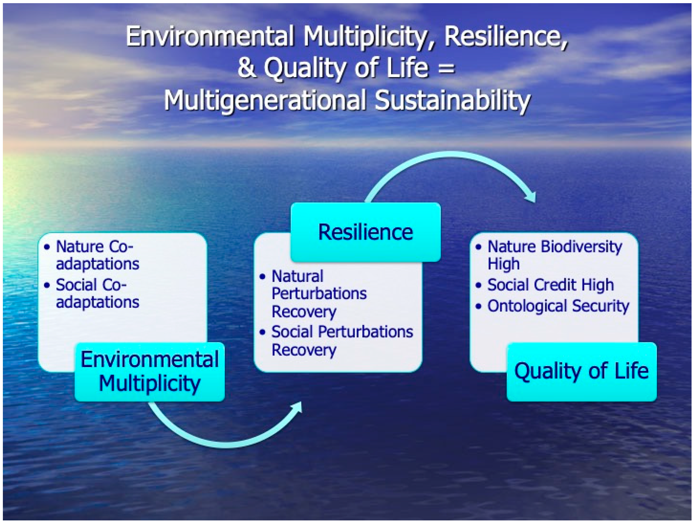
2.1. Environmental Multiplicity
2.2. Littoral
3. Methods
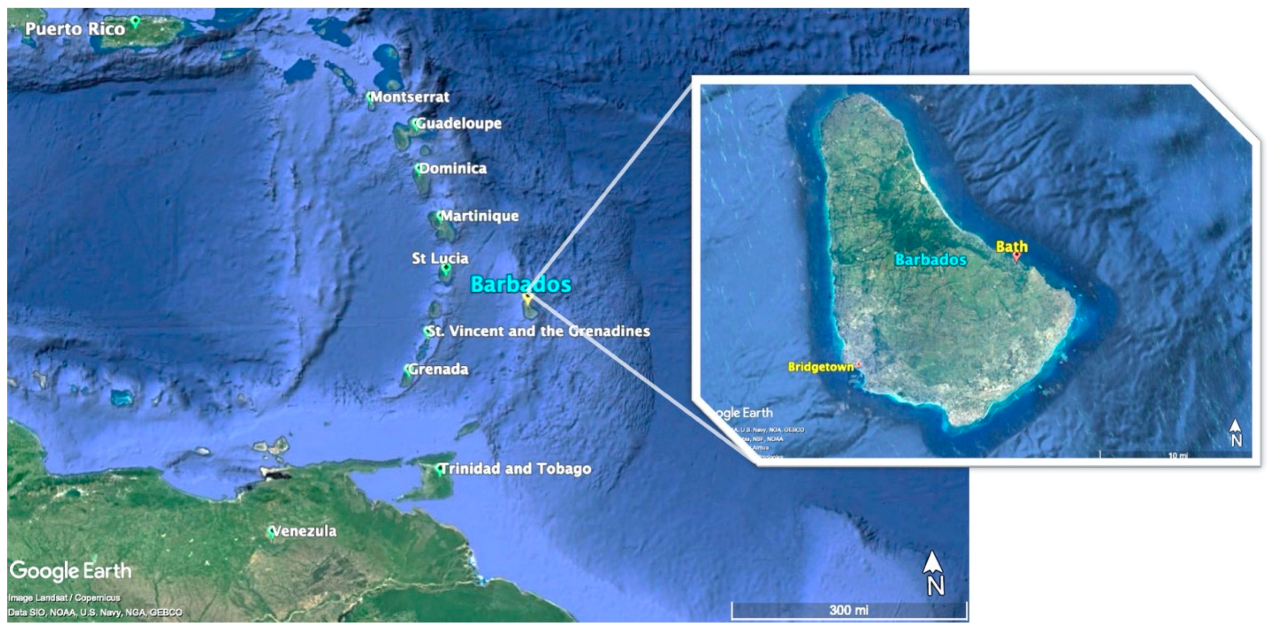
3.1. Barbados
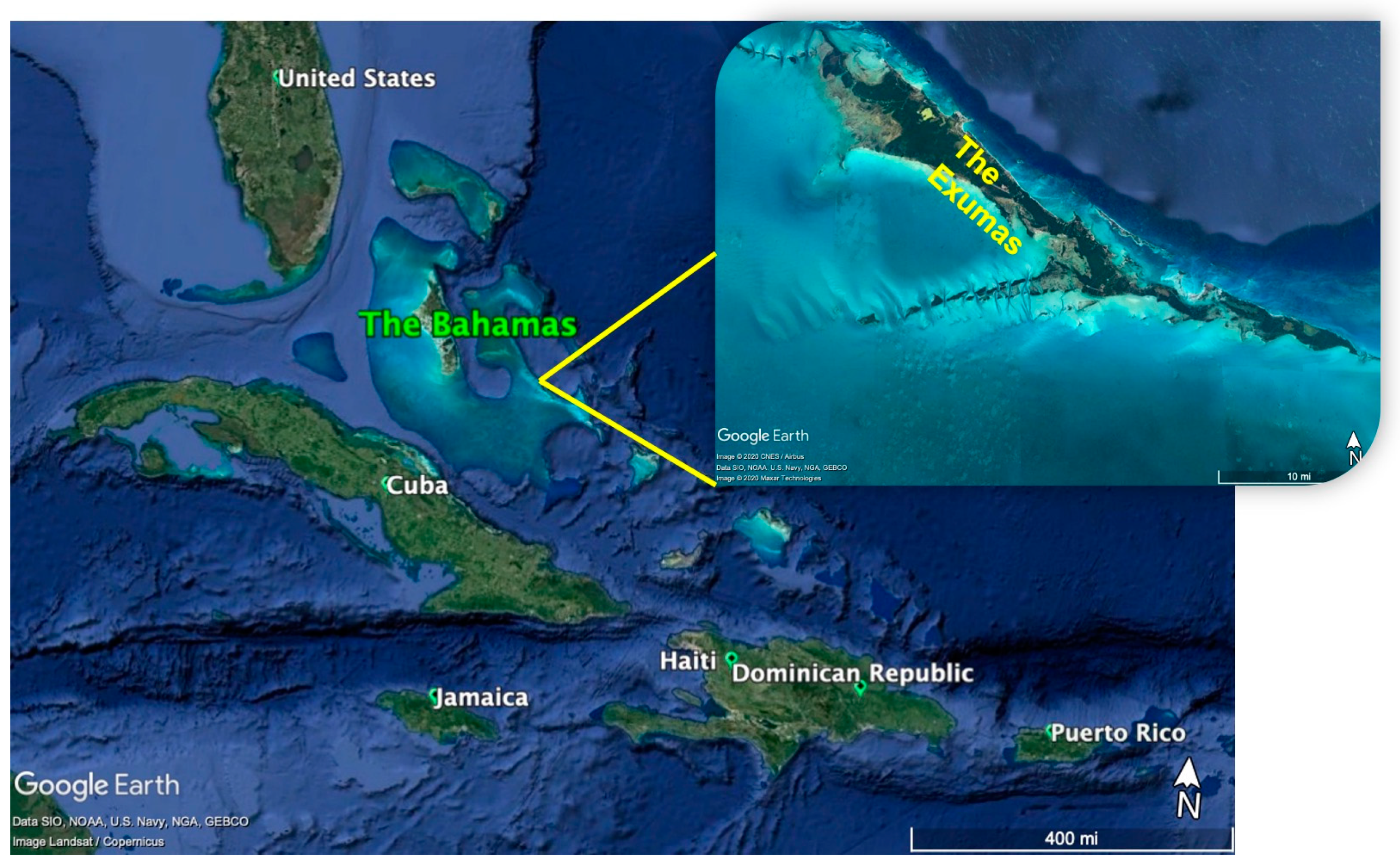
3.2. The Bahamas
4. Cases
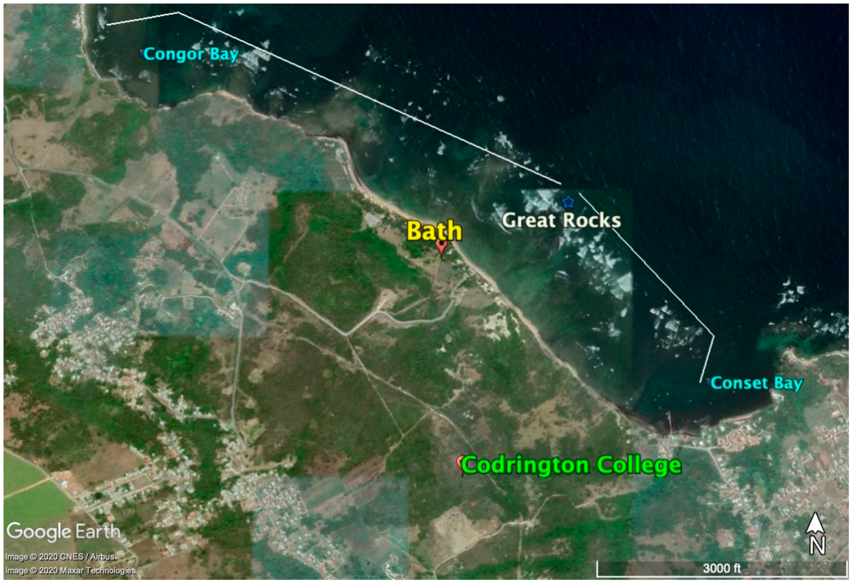
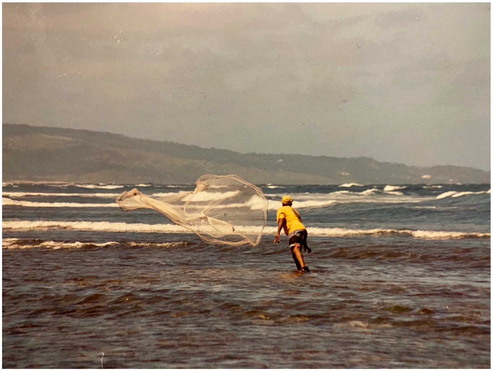
4.1. Case One: Barbados
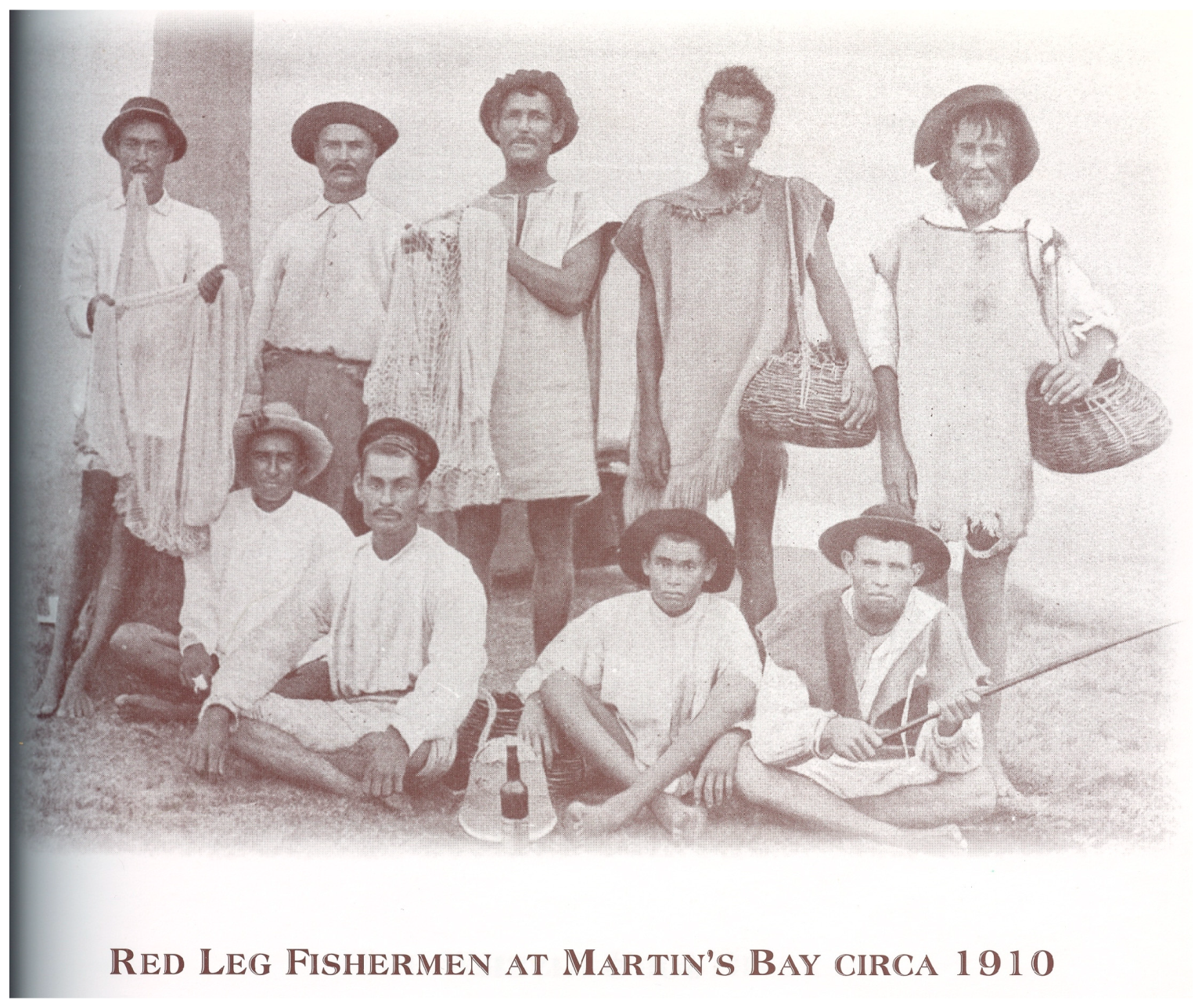
“that Indian women were primarily, if not solely, employed in household tasks. On the other hand, the men...were use for footmen, and killing of fish, which they are good at. With their own bows and arrows they will go out, and in a day’s time kill as much fish as will serve a family of a dozen persons two or three days, if you can keep the fish so long”.
“I had to give up being a teacher even though I enjoyed it. Even though I had a steady paycheck I couldn’t always make enough money to make sure that everyone was fed. I would still fish at that time but because of my commitment to the school I wasn’t able to do it as often as I needed to. So, I gave up being a teacher and went to the sea full time. I would fish all day and all night, sometimes inside Great Rocks and sometimes outside. Even though I made a lot less money, I was able to make sure that everyone ate. My brothers and sisters never went hungry because the sea always provides.”
4.2. Case Two: The Bahamas
4.2.1. History of Bahamian Case
4.2.2. Grubbing: Unique Ecology of Case
4.2.3. Exposed Mangroves and the Grubbing Circle
“They would make the water muddy in the mangrove because when the water get muddy, if any moray in there, they gonna come out [and go away]. They [the fish] gonna get drunk and they gonna keep pushing their head in the mud…they gonna keep making a noise like a grunt, so you know just where they is.”
4.2.4. Sustainability and Grubbing
5. Discussion
Author Contributions
Funding
Acknowledgments
Conflicts of Interest
Appendix A

| Land Animal Name | Scientific Name | Local Name | Location | Interaction |
|---|---|---|---|---|
| Land crab | Swampy, Land Crab | brackish freshwater springs before ocean | food source, bait for hand line fishing | |
| Marsh Fiddler crab | Uca pugnax | Stone Crab | Shoreline | Food source |
| Bahamaian Nighthawk | Choredeiles gundlachii | Nighthawk | Shores, marshes, estuaries, grassy wetland areas | Eats insects that bother people |
| Blue Crab | Callinectes sapidus | Blue crab | Shores, marshes, estuaries, grassy wetland areas | Food source |
| Blue Heron | Adrea herodias | Arsenicker | Shoreline | Food source, prey on crabs |
| Crescent-eyed Pewee | Contopus caribaeus | Pewees | Mangroves, edges of clearings | Eats insects that bother people |
| Green Heron | Butorides virescens | Gaulin birds, Poor Joe | Shoreline | Eat crabs that would come into gardens and eat crops, stories |
| Hermit Crab | Paguristes ssp. | Hermit crab, Solider crab | Reefs, shallows, sand patches | Food source |
| Killdeer | Charadrius vociferus | Killdeer | Shores, marshes, estuaries, grassy wetland areas | National symbol |
| Laughing Gull | Larus atricilla | Sea gulls | Salt marshes, lagoons | Indicates schools of fish |
| Least Tern | Sterna antillarum | Gulls | Shoreline | Fed and cared for by people |
| Mangrove crab | Cardisoma guanhumii | Land Crab, Cigga | Mangroves | Put nicker bean in crab hole to prevent them from destroying garden, used for crawfish bait |
| Osprey | Pandion haliaetus | Fish Hawk | Nest near the ocean | Eat eggs, story of climbing to the nest of the hawk to get eggs |
| Pigeon | Columba leucocephala | White Crown Pigeon | nests in mangroves | Food source |
| West Indian Rock Iguana | Cyclura spp. | Iguanas | Brush, lagoon areas | Tourist attraction, food source |
| Zenaida dove | Zenaida aurita | Wood dove | low lands | Food sources, hunted and eggs eaten |
| Sea Animal Name | Scientific Name | Local Name | Location | Interaction |
|---|---|---|---|---|
| Bonefish | Albula vulpes | Bonefish | Shallow flats near mangroves | Tourist attraction, food source |
| Caribbean Reef Octopus | Octopus brareus | Octopus, sea cat | In shore reefs | Food source |
| Caribbean Spiny Lobster | Panulirus argus | Lobster, crawfish | Reefs, caves, holes, ledges | Food source, not caught during spawning, spawning crawfish thrown back |
| Chiton | Polyplacophora ssp. | Curb | Rocky shores | Food Source |
| Chub | Kyphosus sectatrix | chub | Sea grass beds | Food Source |
| Conger Eels, Garden Eel | Nystactichtys halis | conga eel | shallows | Food source |
| French Grunt | Pomadasyidae | Grunt | Near reefs, mangroves | Food source |
| Giant Brain Coral | Colpophyllia natans | Coral | Reefs | Made into cement for houses |
| Great Barracuda | Sphyraena barracuda | Barracuda | All, especially reefs | Food source |
| Green Eel, Green Moray | Gymnothorax funebris | green eel | In shore reefs | Food source |
| Hawksbill Turtle | Eretmochelys imbricata | Turtle | Shallow, coastal waters and estuaries | Food source, shells were sold to make jewelry |
| Jolthead Porgy | Calamus bajonado | Porgy | Reefs, sand, coastal interface | Food source |
| Lemon Shark | Negaprion brevirostis | Lemon Shark | Lagoons, estuaries and the shallows | Food source, helps fight cancer, skin used for fertilizer |
| Mangrove Snapper | Lutjanus griseus | Snapper | Near mangroves | Food source |
| Nassau Grouper | Epinephelius striatus | Grouper | Shallow to mid-range reefs | Food source, grouper is not caught during spawning |
| Nurse shark | Ginglymostoma cirratum | Nurse Shark | All (shallow and deeper) | Skin used to fertilize gardens |
| Parrotfish | Sparisoma viride | queen parrotfish | Reefs, sea grass beds | Food source |
| Crevalle | Caranx hippos | jack crevalle, rainbow crevalle | located in shallows as well as offshore | Food Source |
| Queen Conch | Strombus gigas | Conch | Sand and eel grass beds | Food source |
| Queen Triggerfish | Balistes ssp. | Triggerfish | Reef tops | Food source |
| Reticulated Sea Star | Oreaster reticulatus | Starfish | Eel grass beds | Tourist attraction |
| Sea Sponge (1.) Yellow Tube Sponge (2.) Red Cup Sponge | (1.) Aplysina fistularis (2.) Mycale Laxissima | sponges | Cleaning, songs are made about going sponging, today spongers uses knives, so sponges grow back | |
| Sea Urchins | Tripneusts ventricosus | Sea eggs | Sea grass beds | Food source, shells sold, shells ground and burned, ground into lime to build houses, black ones used for bate for Jacks |
| Plant Name | Scientific Name | Local Name | Location | Interaction |
|---|---|---|---|---|
| Ambrosia hispida | Bay Tansy, Baygereen | Beaches, dune sands or occasionally on rocky shelves along coast | Medicinal properties | |
| Black mangrove | Avicennia germinans | Black Buttonwood | Mangrove lagoons and along tidal shore | Medicinal properties |
| Sea Ox-eye | Borrichia arborescens | Coastal sands and rock and margins of brackish water | Medicinal properties | |
| Nicker bean | Caesalpina bonduc | Nickers | Native to seacoasts | Children use the seeds as marbles and playing pieces in Wari, a traditional African game widely played in the West Indies, medicinal properties |
| Seven-year apple | Casasia clusiifolia | Coastal rocks but also in coppices | Edible wild plant | |
| Cassytha filiformis | Love vine | Parasitic on various herbaceous and woody plants | Medicinal properties | |
| Cocoplum | Chrysobalanus icaco | Coastal swamps and thickets along sea beaches | Edible wild plant | |
| Sea grape | Coccoloba uvifera | Coastal thickets and rock outcrops | Edible wild plant | |
| Silver thatch | Coccothrinax argentata | Silver Top | In coastal flats along beaches | Plaiting and making straw crafts, thatch material for roofs |
| Coconut palm | Cocos nucifera | Thrives in the low tropics, especially in coastal sands | Food, boat building wood, aesthetic qualities, medicinal properties, plaiting and making straw crafts | |
| Button wood | Conocarpus erectus | Coastal mud, savannas and edge of salines | Boat building wood, source of driftwood used for decoration in homes | |
| Lignum vitea | Guaiacum sanctum | Rocky slopes and ridges, seaside ledges, palm-shrub associations, and dense coppices | National tree of Bahamas, medicinal properties, boat building wood | |
| Pigeon berry | Guapira longifolia | Coppices, scrublands, and on rock flats, often along the coast and on ridges | Recognized as a main food source for wild pigeons. Used during the hunting season to find pigeons | |
| Horse Bush | Gundlachia corymbosa | Clayey or rocky saline flats, marshes, dune sands, pinelands, edge of coppices | Medicinal properties | |
| Log wood | Heamatoxylum campechianum | Coastal thickets, hillsides and on edge of salinas and periodically flooded places | Medicinal properties | |
| Wild Dilly | Manilkara bahamensis | Coppices or scrublands, especially along coastal areas and on rock flats | Edible wild plant, medicinal properties, fruit chewed as chewing gum |
Appendix B. Urban Gardening
Appendix B.1. Cuba Urban Gardening
Appendix B.2. Detroit, Urban Gardens
Appendix B.3. New York City Urban Gardening
References
- Stoffle, R. When Fish Is Water: Food Security and Fish in a Coastal Community in the Dominican Republic. In Understanding the Cultures of Fishing Communities: A Key to Fisheries Management and Food Security; FAO Fisheries Technical Paper: Rome, Italy, 2001; pp. 219–245. [Google Scholar]
- Stoffle, R.; Halmo, D.; Wagner, T.; Luczkovich, J. Reefs from Space: Satellite Imagery, Marine Ecology, and Ethnography in the Dominican Republic. Hum. Ecol. 1994, 22, 355–378. [Google Scholar] [CrossRef]
- Stoffle, R. Caribbean Fisherman Farmers: A Social Impact Assessment of Smithsonian King Crab Mariculture; Institute for Social Research: Ann Arbor, MI, USA, 1986. [Google Scholar]
- Stoffle, B. The Socio-Economic Importance of Fishing in St. Thomas, USVI: An Examination of Fishing Community Designation; Technical Memorandum NMFS-SEFSC-623; NOAA: Miami, FL, USA, 2011.
- Stoffle, B.; Waters, S.; Abbott-Jamieson, S.; Kelley, S.; Grasso, D.; Freibaum, J.; Koestner, S.; O’Meara, N.; Davis, S.; Stekedee, M.; et al. Can an Island Be a Fishing Community: An Examination of St. Croix and Its Fisheries; U.S. Department of Commerce, National Oceanic and Atmospheric Administration National Marine Fisheries Service Southeast: Miami, FL, USA, 2009.
- Williams, E. Capitalism and Slavery; University of North Carolina Press: Chapel Hill, NC, USA, 1994. [Google Scholar]
- Browne, K. Creole Economics: Caribbean Cunning under the French Flag; University of Texas Press: Austin, TX, USA, 2004. [Google Scholar]
- Berkes, F.; Turner, N. Knowledge, Learning and the Evolution of Conservation Practice for Social-Ecological System Resilience. Hum. Ecol. 2006, 34, 479–494. [Google Scholar] [CrossRef]
- Stoffle, R.; Toupal, R.; Zedeno, N. Landscape, Nature, and Culture: A Diachronic Model of Human-Nature Adaptations. In Nature across Cultures: Views of Nature and the Environment in Non-Western Cultures; Selin, H., Ed.; Kluwer Publishers: Dordrecht, The Netherlands, 2003; pp. 97–114. [Google Scholar]
- Olsson, P.; Folke, C. Local Ecological Knowledge and Institutional Dynamics for Ecosystem Management: A Study of Lake Racken Watershed, Sweden. Ecosystems 2001, 4, 85–104. [Google Scholar] [CrossRef]
- Stoffle, R.; Minnis, J. Resilience at Risk: Epistemological and Social Construction Barriers to Risk Communication. J. Risk Res. 2008, 11, 55–68. [Google Scholar] [CrossRef]
- Connell, J.H. Diversity in Tropical Rain Forests and Coral Reefs. Science 1978, 1999, 1302–1310. [Google Scholar] [CrossRef] [PubMed]
- Turner, N.; Davidson-Hunt, I.; O’Flaherty, M. Living on the Edge: Ecological and Cultural Edges as Sources of Diversity for Social-Ecological Resilience. Hum. Ecol. 2003, 31, 439–461. [Google Scholar] [CrossRef]
- Nabhan, G. Enduring Seeds: Native American Agriculture and Wild Plant. Conservation; North Point Press: San Francisco, CA, USA, 1989. [Google Scholar]
- Wandsnider, L.; Chung, Y. Islands of Geophytes: Sego Lily and Wild Onion Patch Density in a High Plains Habitat. In Islands on the Plains: Ecological, Social, and Ritual Use of Landscapes; Kornfield, M., Osborn, A., Eds.; University of Utah Press: Salt Lake City, UT, USA, 2003; pp. 220–244. [Google Scholar]
- Anderson, R. Dating Reindeer Pastoralism in Lapland. Ethnohistory 1958, 5, 361–391. [Google Scholar] [CrossRef]
- Fowler, C.; Minnis, P.; Elisens, W. We Live by Them: Native Knowledge of Biodiversity in the Great Basin of Western North America. In Biodiversity & Native America; University of Oklahoma Press: Norman, OK, USA, 2000. [Google Scholar]
- Atran, S.; Medin, D.; Ross, N.; Lynch, E.; Vapnarsky, V.; Ucan Ek’, E.; Coley, J.; Timura, J.; Baran, M. Folkecology, Cultural Epidemiology, and the Spirit of the Commons: A Garden Experiment in the Maya Lowlands, 1991–2001. Curr. Anthropol. 2002, 43, 421–450. [Google Scholar] [CrossRef]
- Turner, N. We Give Them Seaweed: Social Economic Exchange and Resilience in Northwestern North America. Indian J. Tradit. Knowl. 2016, 15, 5–15. [Google Scholar]
- Berkes, F.; Colding, J.; Folke, C. (Eds.) Navigating Social—Ecological Systems: Building Resilience of Complexity and Change; Cambridge University Press: New York, NY, USA, 2003. [Google Scholar]
- Holling, C.S. Resilience and Stability of Ecological Systems. Annu. Rev. Ecol. Syst. 1973, 4, 1–23. [Google Scholar] [CrossRef]
- Comitas, L. Occupational Multiplicity in Rural Jamaica. In Proceedings from the American Ethnological Society; American Ethnological Society: Washington, DC, USA, 1964. [Google Scholar]
- McCay, B. Presidential Address Part II: Edges, Fields, and Regions. Common Prop. Resour. Dig. 2000, 54, 6–8. [Google Scholar]
- Stoffle, B.; Stoffle, R. At the Sea’s Edge: Elders and Children in the Littorals of Barbados and the Bahamas. Hum. Ecol. 2007, 35, 547–558. [Google Scholar] [CrossRef][Green Version]
- Besson, J.; Momsen, J. Land and Development in the Caribbean; MacMillan: Centre for Caribbean Studies, University of Warwick: London, UK, 1987. [Google Scholar]
- Barrow, C. Small Farm Food Production & Gender in Barbados. In Women and Change in the Caribbean: A Pan-Caribbean Perspectiv; Momsen, J., Ed.; Indiana University Press: Bloomington, IA, USA, 1993; pp. 181–193. [Google Scholar]
- Mokyevsky, O. Geographical Zonation of Marine Types. Limnol. Oceanogr. 1960, 5, 389–396. [Google Scholar] [CrossRef]
- Stoffle, R.; Minnis, J. Marine Protected Areas and the Coral Reefs of the Traditional Settlement in the Exumas, Bahamas. Coral Reefs 2007, 26, 1023–1032. [Google Scholar] [CrossRef][Green Version]
- Stoffle, R.; Minnis, J.; Murphy, A.; Van Vlack, K.; O’Meara, N.; Smith, T.; McDonald, T. Two-MPA Model for Siting a Marine Protected Area: Bahamas Case. Coast. Manag. 2010, 38, 501–517. [Google Scholar] [CrossRef]
- Unviersity College of London. Legacies of British Slave-Owernship. Available online: https://www.ucl.ac.uk/lbs/estates/ (accessed on 5 April 2020).
- Tashakkori, A.; Teddlie, C. Mixed Methodology: Combining Qualitative and Quantitative Approaches; Sage Publications: Thousand Oaks, CA, USA, 1998. [Google Scholar]
- Beebe, J. Rapid Assessment Process; Altamira Press: Walnut Creek, CA, USA, 2001. [Google Scholar]
- Campbell, D.; Fiske, D. Convergent and Discriminant Validation by the Multi-Trait-Multimethod Matrix. Psychol. Bull. 1959, 56, 81–105. [Google Scholar] [CrossRef] [PubMed]
- Jick, T. Mixing Qualitative and Quantitative Methods: Triangulation in Action. Adm. Sci. Q. 1979, 24, 601–611. [Google Scholar] [CrossRef]
- Gmelch, G.; Gmelch, S. The Parish behind God’s Back: The Changing Culture of Rural Barbados; Waveland Press: Long Grove, IL, USA, 1997. [Google Scholar]
- Stoffle, B. We Don’t Put All of Our Eggs in One Basket: An Examination of Meeting Turn, A Rotating Savings and Credit Association in Barbados. Ph.D. Thesis, University of South Florida, Tampa, FL, USA, 2001. [Google Scholar]
- Stoffle, B.; Stoffle, R.; Minnis, J.; Van Vlack, K. Women’s Power and Community Resilience Rotating Savings and Credit Associations in Barbados and the Bahamas. Caribbean Stud. 2014, 42, 45–69. [Google Scholar] [CrossRef]
- Stoffle, R.; Zedeno, N. Historical Memory and Ethnographic Perspectives on Southern Paiute Homeland. J. Calif. Gt. Basin Anthropol. 2001, 23, 229–248. [Google Scholar]
- Stoffle, R.; Van Vlack, K.; O’Meara, N. Environmental Multiplicity in the Exumas, Bahamas: A Social and Natural Resilience Model. Appl. Anthropol. 2017, 37, 15–21. [Google Scholar]
- Handler, J. The Amerindian Slave Population of Barbados in 17th and Early 18th Centuries. Caribbean Stud. 1969, 8, 38–64. [Google Scholar]
- Handler, J. Aspects of Amerindian Ethnography in 17th Century Barbados. Caribbean Stud. 1970, 9, 50–72. [Google Scholar]
- Watts, D. The West. Indies: Patterns of Development, Culture, and Environmental Change Since 1492; Cambridge University Press: Cambridge, UK, 1987. [Google Scholar]
- Ligon, R. A True and Exact History of the Island of Barbados, 5th ed.; Smith, D.C., Ed.; Wilfrid Laurier University: London, UK, 1657. [Google Scholar]
- Bennett, J.H. The Problem of Slave Labor Supply at the Codrington Plantations. J. Negro Hist. 1951, 36, 406–441. [Google Scholar] [CrossRef]
- McKinnen, D. A Tour through the British West. Indians in the Year 1802 and 1803; Forgotten Books: London, UK, 1804. [Google Scholar]
- Hawthorne, N. The Yarn of a Yankee Privateer; Funk & Wagnalls Company: New York, NY, USA, 1926. [Google Scholar]
- Yates, A.W. Bygone Barbados; Black Bird Studies: Christ Church, Barbados, 1998. [Google Scholar]
- Barbados Today. Bajan Gems- Fred Watson. Available online: https://www.youtube.com/watch?v=7_Kdupmmba4 (accessed on 4 April 2020).
- Craton, M.; Saunders, G. Islanders in the Stream: A History of the Bahamian People. Volume Two: From the Ending of Slavery to the Twenty-First Century; University of Georgia Press: Athens, GA, USA, 1999. [Google Scholar]
- Keegan, W.; Mitchell, S. Possible Allochthonous Lucayan Arawak Artifact Distributions, Bahama Islands. J. Field Archaeol. 1986, 13, 255–258. [Google Scholar]
- Saunders, G. Slavery in the Bahamas: 1648–1838; Nassau Guardian: Nassau, Bahamas, 1995. [Google Scholar]
- Wilkie, L.; Farnsworth, P. Sampling Many Pots: An Archaeology of Memory and Tradition at a Bahamian Plantation; University Press of Floria: Gainesville, FL, USA, 2005. [Google Scholar]
- Johnson, H. The Bahamas from Slavery to Servitude, 1783–1933; University Press of Floria: Tallahassee, FL, USA, 1996. [Google Scholar]
- Farnsworth, P. From the Past to the Present. In African Sites: Archaeology in the Caribbeam; Markus Wiener: Princeton, NJ, USA, 1999; pp. 94–130. [Google Scholar]
- Woods, C.; Sergile, F. Biogeography of the West Indies; CRC Press: Boca Raton, FL, USA, 2001. [Google Scholar]
- Pimm, S. The Balance of Nature? Ecological Issues in the Conservation of Species and Communities; University of Chicago Press: Chicago, IL, USA, 1991. [Google Scholar]
- Stoffle, B.; Halmo, D.; Stoffle, R.; Burpee, C. Folk Management and Conservation Ethics among Small-Scale Fishermen of Buren Hombre, Dominican Republic. In Folk Management in the World’s Fisheries; Dyer, C., McGoodwin, J., Eds.; University of Colorado Press: Boulder, CO, USA, 1999; pp. 115–138. [Google Scholar]
- Olwig, K.F. Cultural Adaptation and Resistance on St. John: Three Centuries of Afro-Caribbean Life; University Press of Floria: Gainesville, FL, USA, 1985. [Google Scholar]
- Stoffle, R.; Stoffle, B.; Sjölander-Lindqvist, A. Contested Time Horizons. In Sustainability Assessment Pluralism, Practice and Progress; Bond, A., Morrison-Saunders, A., Howitt, R., Eds.; Routledge: London, UK, 2013; pp. 51–67. [Google Scholar]
- Olwig, K.F. National Parks. Tourism and Local Development: A West Indian Case. Hum. Organ. 1980, 39, 22–31. [Google Scholar] [CrossRef]
- Chen, W.; Ho, T. The Application of Yantian Cultural Resources in Design Education-Taking the Yantian Community in Tainan as an Example. Sustainability 2020, 12, 2260. [Google Scholar] [CrossRef]
- Strus, M.; Kalisiak-Medelska, M.; Nadolny, M.; Kachniarz, M.; Raftowicz, M. Community-Supported Agriculture as a Perspective Model for the Development of Small Agricultural Holding in the Region. Sustainability 2020, 12, 2656. [Google Scholar] [CrossRef]
- Ellinger, M.; Braley, S. Urban Agriculture in Cuba. Race, Poverty & the Environment. Urban Agric. Cuba Race Poverty Environ. 2010, 17, 14–17. [Google Scholar]
- Jung, Y.; Newman, A. An Edible Moral Economy in the Motor City: Food Politics and Urban Governance in Detroit. Gastronomica 2014, 14, 23–32. [Google Scholar] [CrossRef]
- Cohen, N.; Reynolds, K.; Sanghwi, R. Five Borough Farm: Seeding the Future of Urban Argiculture in New York City; Design Trust for Public Spaces: New York, NY, USA, 2012. [Google Scholar]


© 2020 by the authors. Licensee MDPI, Basel, Switzerland. This article is an open access article distributed under the terms and conditions of the Creative Commons Attribution (CC BY) license (http://creativecommons.org/licenses/by/4.0/).
Share and Cite
Stoffle, B.; Stoffle, R.; Van Vlack, K. Sustainable Use of the Littoral by Traditional People of Barbados and Bahamas. Sustainability 2020, 12, 4764. https://doi.org/10.3390/su12114764
Stoffle B, Stoffle R, Van Vlack K. Sustainable Use of the Littoral by Traditional People of Barbados and Bahamas. Sustainability. 2020; 12(11):4764. https://doi.org/10.3390/su12114764
Chicago/Turabian StyleStoffle, Brent, Richard Stoffle, and Kathleen Van Vlack. 2020. "Sustainable Use of the Littoral by Traditional People of Barbados and Bahamas" Sustainability 12, no. 11: 4764. https://doi.org/10.3390/su12114764
APA StyleStoffle, B., Stoffle, R., & Van Vlack, K. (2020). Sustainable Use of the Littoral by Traditional People of Barbados and Bahamas. Sustainability, 12(11), 4764. https://doi.org/10.3390/su12114764