1. Introduction
Our paper builds on the concepts of inequality, transport accessibility and capabilities to address inequalities in accessibility to non-commuting activities in the (unofficial) Bogotá Metropolitan Region (BMR) in Colombia and their implications for sustainability. We frame the analysis of accessibility within concerns around sustainability, understood as the improvement in the quality of human life within the carrying capacity of supporting ecosystems, involving an improvement of economic, social, environmental and cultural well-being. Rapid urban expansion in the BMR compounded by informal urbanization of the peripheries, a spatially centralized job market and differentiated provision of urban transport infrastructure and services, often delivered through private mechanisms, has produced marked differences in travel capacity between high- and low-income residents [
1,
2].
Modern urban transport planning in the Global South is faced with the twin challenges of addressing longstanding structural deficits in basic infrastructure and the lack of capacity for connectivity, while attempting to reduce marked social, spatial, economic and environmental inequalities. Such inequalities are associated with both land development models driven by strong market forces and informal practices that attempt to respond to the needs of socially vulnerable populations and by public–private models of infrastructure development and supply of public transport that have enhanced connectivity in some areas while bypassing poorer and commercially less attractive parts of cities.
This research aims at producing evidence that enables critical examination of the conceptual and empirical links between accessibility, equity and sustainability using non-work accessibility as a core metric. By researching the case of Bogotá, we seek to produce new knowledge and evidence of how we understand, research and respond to transport inequalities, seeking to provide tools for more inclusive urban and transport planning in cities. The paper builds on an already well-documented case of urban transport development from an accessibility perspective and revisits a case study and information not previously explored from this perspective.
Understanding drivers of accessibility to opportunities other than work and education and their social consequences has implications for policy and planning targeting sustainable urban development. This is reflected in international debates, which increasingly focus on how to enable equitable, inclusive and sustainable accessibility through transport policies at all levels [
3]. The transport sector has historically been one of the largest areas in national and local investment globally [
4], and it is critically important that infrastructure investment supports city development objectives.
The Sustainable Development Goals (SDGs) agreed upon by the United Nations [
5] state as part of the targets of Goal 11 (sustainable cities and communities) that transport plays an essential role in achieving sustainable development. Such targets highlight the role of transport in bridging disparities across social groups and socioeconomic conditions. Moreover, the New Urban Agenda highlights the promotion of equitable access, with emphasis on low-income and peripheral urban populations to sustainable transport that enables participation in both social and economic activities [
5].
An urban environment that necessitates physical movement as a precondition for benefitting from most opportunities limits people’s access to goods and services and the ability to travel to activities that are relevant for a full participation in society [
6,
7,
8]. These conditions are often reinforced by poverty and a low quality of public transport services, especially in peripheral neighborhoods with low access to private motorized vehicle use. Cities in the Global South tend to be more spatially and socially segregated than those in wealthy nations, partly as a consequence of land-use patterns developed through a succession of narrowly conceived urban plans that strictly segregate land uses using social and functional criteria.
It is in this context that the Capability Approach (CA) can be potentially useful in understanding and addressing the challenge of achieving sustainable mobility and accessibility in Global South cities. Capabilities are understood as the freedoms people have to secure opportunities that they consider valuable, which can be linked with material, relational and subjective well-being [
9]. The approach to transport from a capabilities perspective incorporates the strategies (or “choices”) that people develop to pursue well-being aspirations, the skills and capacities (“abilities”) to materialize such strategies, and the structural elements that condition the availability of strategies and skills (“opportunities”). In the capability language, the links between transport and society are understood in terms of freedoms and opportunities available for choices and actions, which are the combined result of personal abilities, and the political, social and physical environments in which individuals operate [
10]. Nussbaum [
11] argues that there are ten core capabilities or rights that should be supported by all democracies. Such rights encompass life and health, emotions, practical reason and control over one’s environment. Mobility and accessibility are a fundamental precondition for realizing most of these rights [
12], which adds relevance to the examination of accessibility to different opportunities across seemly unequal environments such as Bogotá.
This paper is based on the recognition that transport can allow or restrict access to material assets, social connections and opportunities that help build human and social capital beyond work and education. These different capitals contribute directly to social mobility and inclusive economic development. In this sense, access to opportunities, services and goods can also be framed by modern concerns in transport planning, such as health, universal mobility (disabilities) and the quality of the environment.
One of the main objectives of urban policy regarding accessibility is equal access to activities in the city that ensure enhanced quality of life in a sustainable local and global environment. Evidence in this paper informs reflections on the implications of sustainable mobility in relation to the ability of citizens to exercise freedom of movement without social control or under restrictions imposed by their surrounding natural and built environment. By linking accessibility with capabilities and inequality, we provide a critical examination of the distribution of material benefits and burdens of urban mobility in a context of sustainable urban mobility.
2. Accessibility, Capabilities and Equity in a Context of Sustainability: Making the Links
We approach urban mobility as a cross-cutting issue in exercising the Right to the City [
13], a driver of large-scale and resource-intensive infrastructure and urban transformation processes, a large contributor to carbon pollution, and ultimately a determinant of the capacity of individuals to live a life that they have a reason to value [
4,
14]. In most urban contexts, deficits in urban mobility are positively correlated with lower income, reduced social participation, higher risk of non-transmittable diseases and exposure and vulnerability to environmental risks and traffic fatalities, which makes it a driver of urban inequalities mediated by the intersection of different social identities marked by differences in race, gender, age, ethnicity and physical and cognitive disabilities [
15,
16,
17,
18,
19,
20,
21].
Urban mobility is also transversal to different definitions of wellbeing, becoming an interesting area for testing the applicability of different frameworks and methodologies for measurement. An example of the many understandings of wellbeing in the academic literature is the Capability Approach (CA), which draws from the work of Amartya Sen [
22,
23,
24] and Martha Nussbaum [
10,
25,
26]. Initially rooted in welfare economics, the CA addresses the different scales of structures that influence how people interact and make decisions in relation to their own interpretations of well-being [
27]. The capability framework has permeated policy via the Sustainable Livelihoods Framework [
28], which describes how capabilities, which are embedded in evolving contexts and built on widely diverse personal and collective resources, are converted to valued wellbeing outcomes [
29]. Consequently, this framework can be potentially useful in the analysis of the well-being outcomes in the transport field as it enabled transport options or “choices” to be differentiated and to be linked with desirable well-being dimensions.
Different social groups and individuals experience variable levels of aspiration and capacity to travel and carry out health-related, leisure and social activities, and these are determined by differences of spatial location, social identity, socioeconomic conditions, levels of participation and agency and availability of transport modes. The CA acknowledges the role of the surrounding environment in enhancing or restricting a person’s set of opportunities that are available to choose from. From this perspective, a central concern is the promotion of basic capabilities. There is a connection between these basic capabilities and the satisfaction of basic needs [
26,
30,
31]. Research on capabilities related to transport suggest that it is necessary not only to consider the diversity of individuals’ characteristics, but also the “societal structures and constraints affecting individuals’ capacities to convert resources and opportunities into functionings” [
28] (p. 176).
Transport is intimately connected to the way people engage with geographies and constantly re-defines the meaning of space in our lives [
32]. Transport is an enabling agent for human activities, and the demand for it is a function of the desire and capacity of individuals to perform a given activity, as well as the distribution of opportunities across the urban space. The availability of transport and the conditions to make use of it are determining factors in whether an activity can or cannot take place [
33,
34], which is also affected by land-use patterns and planning decisions. However, the desire and capacity to access and therefore carry out activities are determined by the availability of assets, opportunities and abilities for different individuals and social groups. A relevant concern in modern transport planning is the existence of systemic inequalities in the availability of such assets, opportunities and abilities, framed by case-specific normative, social and political constraints, which have negative implications for sustainability, economic development and social equity (see, for example, [
21,
35,
36]).
The interaction between individuals and their surrounding environment is known as “combined capabilities” [
10]. Considering that accessibility relates to the role of the land-use and transport systems in society, which will give individuals or groups of individuals the opportunity to participate in activities in different locations [
37], the links between mobility and capabilities is expanded into an understanding of accessibility as a combined capability [
30,
31]. Such interpretation is supported by the understanding of accessibility as the “ease of reaching desired destinations given a number of available opportunities and intrinsic impedance to the resources used to travel from the origin to the destination” [
20], recognizing that these opportunities and impedance are in a reciprocal relationship with the social position of transport users, and the spatial structure and distribution of activities in cities.
We argue that both capabilities and functionings are associated with the social position of individuals, their agency and conditions for participation, their socioeconomic characteristics and the availability of means to travel, among other factors. In this regard, different social groups (i.e., high vs. low income) will have different aspirations and access patterns, which in turn will determine differences in well-being. Coupled with this is the idea of “Liveable urbanism”: community-led development within the carrying capacity of the planet, where urban dwellers “have connections to networked infrastructures, livelihoods that make it possible to pay for services and often a sense of community solidarity” [
38]. We propose an interpretation of sustainable accessibility that draws on these principles and those of the CA. It implies a mobility that balances out accessibility demands, needs and capacities on the one hand, and preservation of the environment on the other whilst contributing to achieving important sustainable development goals.
Equity and accessibility are relative and dynamic concepts that change depending on the context and frame of reference. Accessibility reflects interactions between the transport system, the spatial distribution of social groups and opportunities in space, individual characteristics and time constraints [
39]. Accessibility reflects the role of transport as an enabler of opportunities that are relevant for people’s wellbeing, and therefore can encompass everything from employment to social interactions and development of human capital (e.g., through access to education). When interpreting capabilities and functionings as related to accessibility, it is possible to differentiate between people’s aspirations to access to opportunities for a life people have reason to value (capabilities) and what they can actually achieve (functionings). Such opportunities can encompass quality employment, social networks and social capital, education, leisure and retail facilities, among others. As shown by Robeyns [
40], not all capabilities are valuable, and some capabilities are valuable to some people but not to others. The differentiation between capabilities and functionings is fundamental in understanding its links with accessibility. Capabilities are substantial freedoms of what people can potentially do and be, these might or not be valuable to (and thus aspired for by) a person. On the other hand, functionings are actual doings and beings [
40]. The capability literature recognizes the importance of reducing capability inequality between groups to promote equality of opportunity [
24,
41].
Therefore, transport equity can be defined as the reduction of such systematic inequalities—vertically, by reducing the distance between what people would like to access and what they are able to (potential travel vs. realized travel), and horizontally, by increasing the valuable capabilities of socially vulnerable groups, bringing them closer to those of better-off groups. This paper contributes to a growing literature linking frameworks for functional, social and developmental evaluation of transport. Recent examples have incorporated capabilities into the social analysis of urban transport with examples focusing on transport equity [
42] and linking capabilities with accessibility and social exclusion [
30]. However, even in the most recent literature, analysis of global south contexts is still not prominent, with most of the focus being on developed cities and conceptual analysis.
4. Findings
Our focus is on non-mandatory trip purposes because they involve locations that are not related to offices, schools and universities and they offer a relevant contrast to findings in previous research using the same case and dataset (see [
1]). These activities tend to have flexible locations and schedules, which also makes their inclusion in mainstream transport planning more complex [
50]. From a CA perspective, the conditions and purposes under which travel is realized are relevant in terms of the functionings, capabilities and opportunities individuals have for achieving well-being. We interpret functionings as access needs and wants, capabilities as the physical, social and financial ability to access opportunities that are closely related with social identities and positions, and opportunities as the available forms of transport for travel and the locations of activities distributed in space. This interpretation is consistent with the accessibility framework.
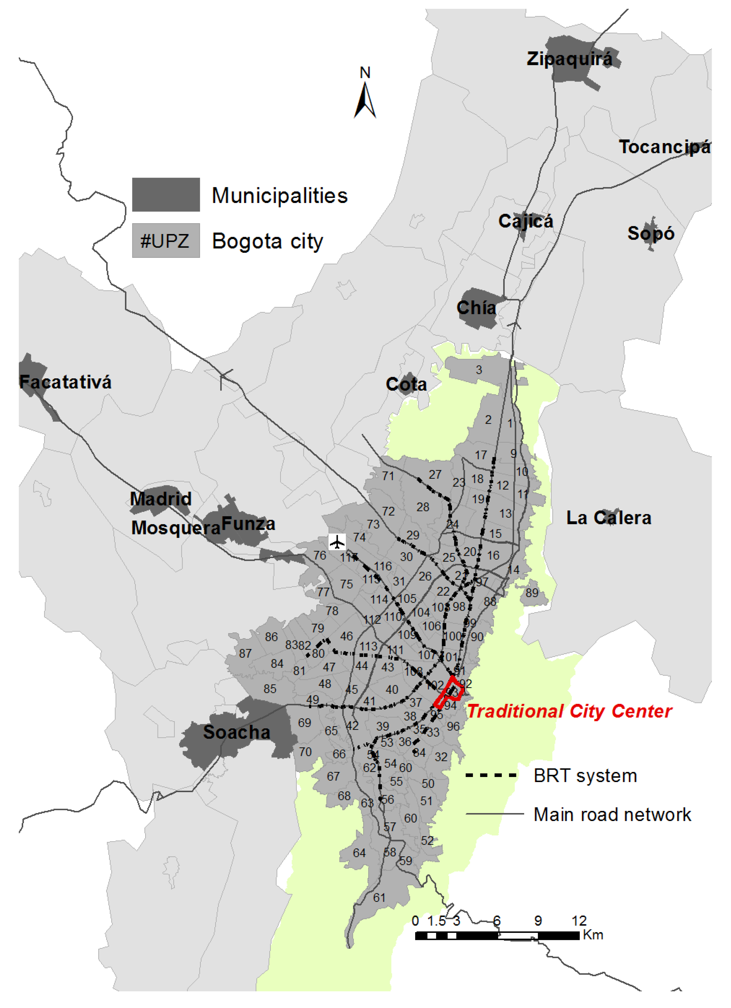
Table 1 reflects proxies to the multiplicity of functionings (purposes) and opportunities for travel involved in non-mandatory travel. Slow modes (walk and bike) are the transport mode used by a large margin of the population in the BMR. This is especially true for the “take/pick up someone” and “shopping” activities, which probably reflects the convenience of walking/biking from home to nearby neighborhood services or commercial centers that offer these activities. Public transport (including BRT, traditional buses and inter-municipal buses) is the second most common choice of mode, followed by cars as the third most popular choice [
1].
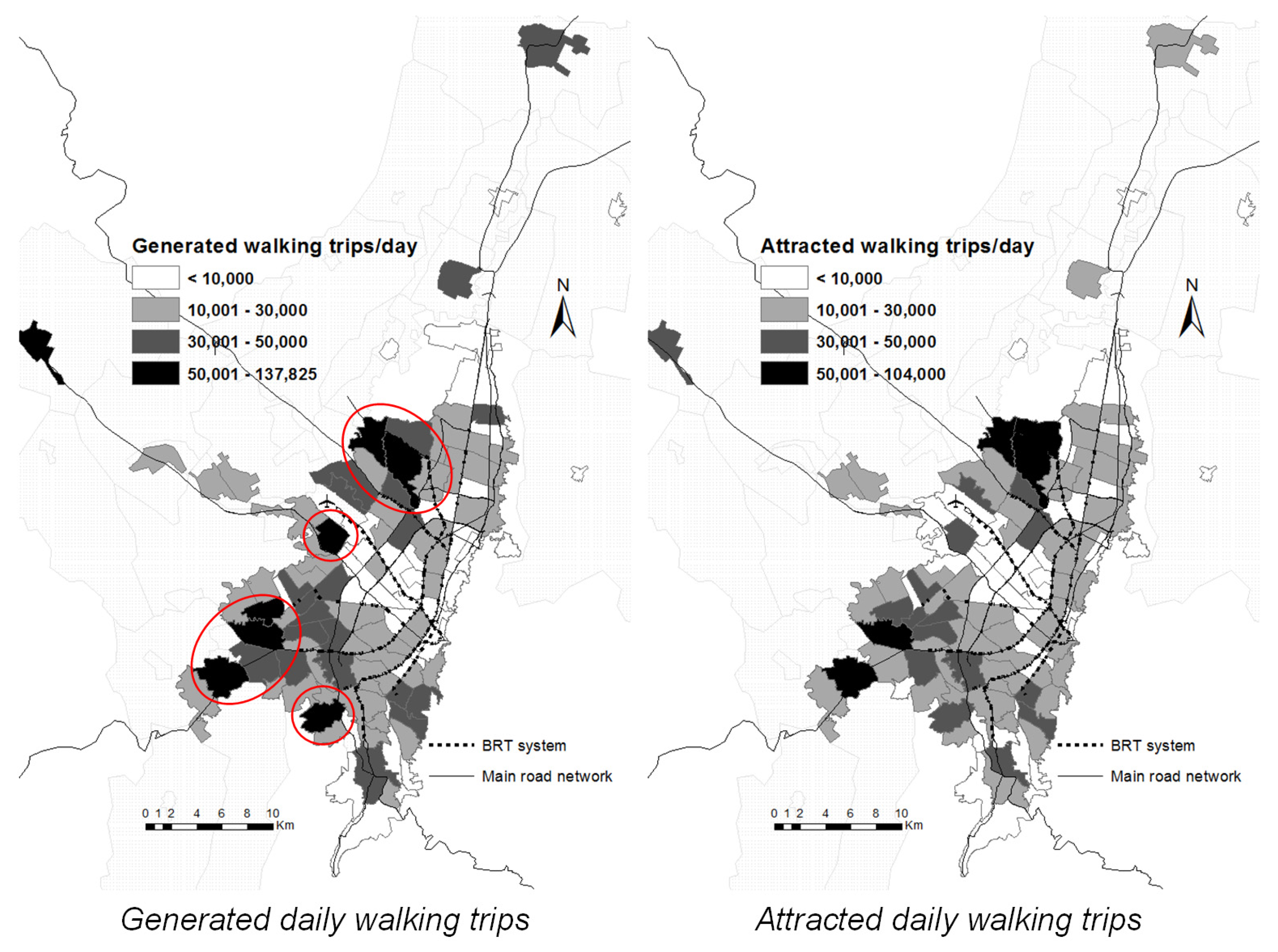
Non-motorized trips are particularly relevant to non-work activities. This is an essential finding in a context of sustainability insofar as is suggests that the distribution of opportunities is aligned with localized capabilities to enable low-carbon access to functionings in essential areas such as leisure, health and care and support. When measuring accessibility by travel time, the attractiveness of opportunities weighted by the time needed to travel from the origin to the destination shows ranges from 5 to 30 min [
51]. The average walking travel time in the BMR is around 15 min, with extreme values between 3 and 50 min. This average travel time suggest an approximate 1.5 km of travel distance for accessing non-mandatory opportunities using low-carbon transport, which enables realizing functionings at a very low marginal environmental cost. These data suggest that a high percentage of these trips generated by each zone (UPZ) have the same zone as its destination, suggesting a more equitable distribution of opportunities for non-work and non-education travel than what has been found in previous research [
1]. As seen in
Figure 4, some particular (marked) zones allocated in the urban periphery concentrate around 45% of both generated and attracted non-mandatory walking trips.
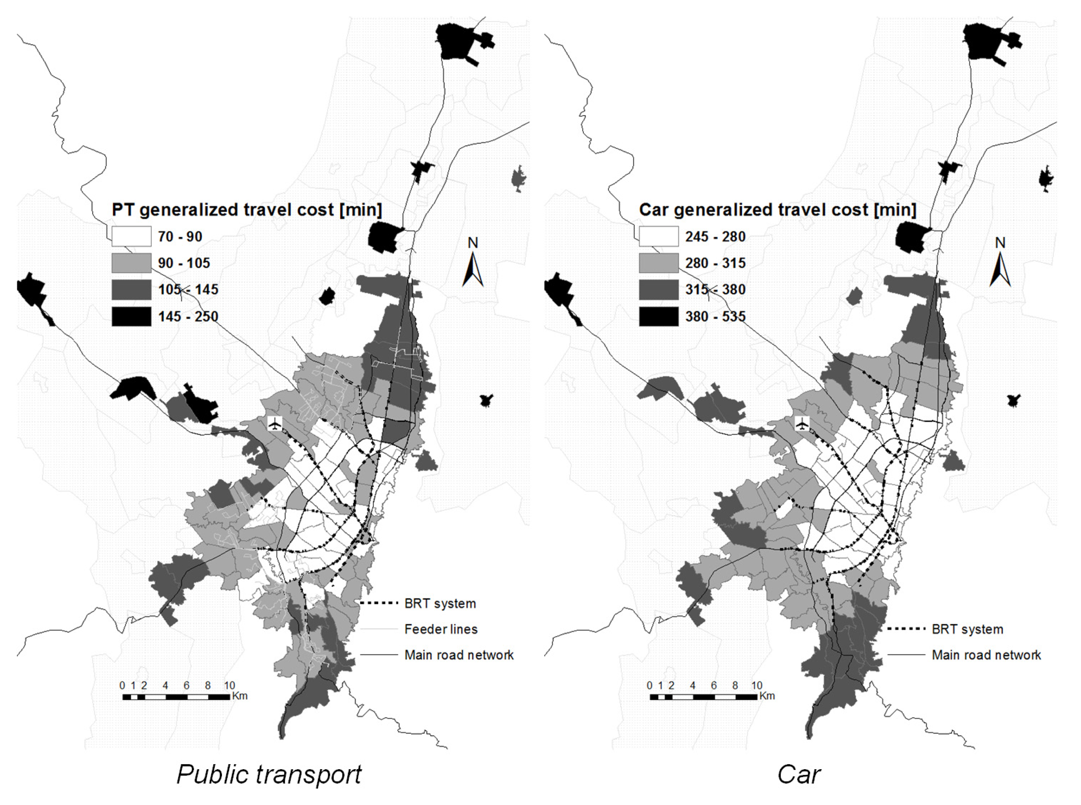
As shown in
Figure 3 and
Figure 4, transport options and transport choices in Bogotá can constrain the substantial freedom related to the concepts of accessibility and capabilities. Our initial analysis of distributions of opportunities for non-mandatory activities will serve as references for the societal structures and constraints that may affect the capacity of individuals in different zones of the BMR to access opportunities. The information in
Figure 3 shows how the availability of opportunities for activities in the southern and eastern areas of the city, which are also the lower income areas in the city, leads to higher realized pedestrian and cyclist mobility with non-mandatory purposes. In addition, the description of the environment for non-mandatory accessibility in this section will inform the analysis of accessibility in relation to capabilities and sustainability.
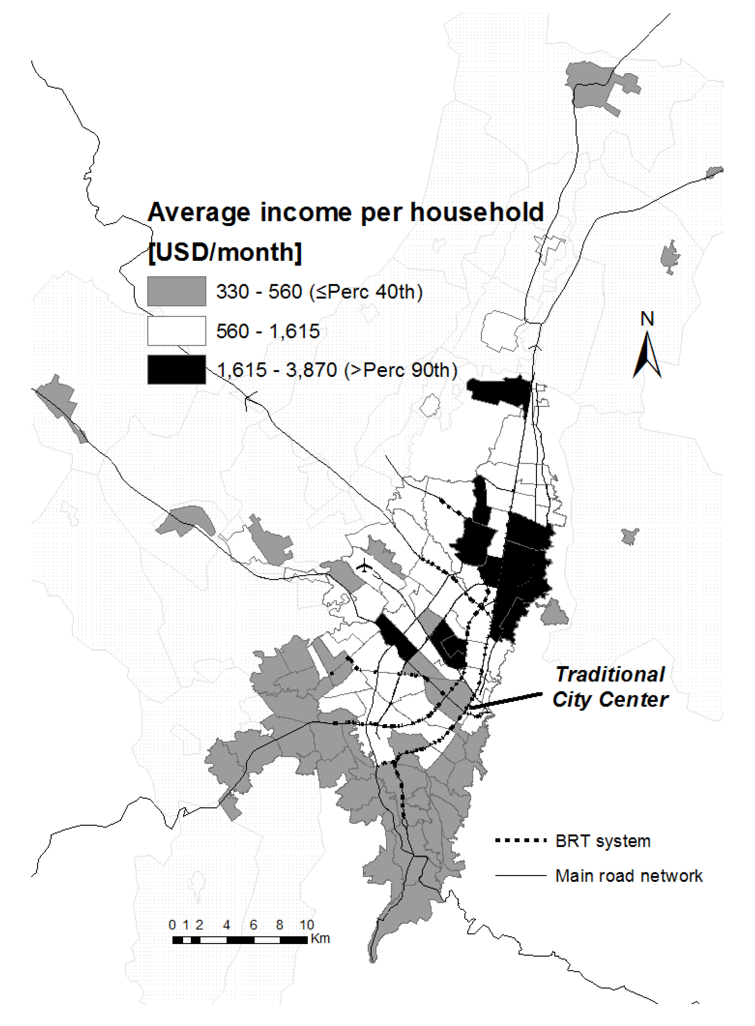
Under the logic proposed by Palma and following the conceptual framework presented, the empirical evidence obtained in this paper assesses the differences in accessibility between higher and lower-income groups. Top earners in the city, or the top 10% in the income distribution curve of Bogotá, were identified geographically. The higher-income group will serve as the benchmark for accessibility of non-mandatory activities. As capabilities are difficult to measure, secondary information described in the previous section from the HTS for the BMR and mainstream transport data sources were used, as these tend to reflect functionings better. However, considering the spatial structure of the BMR and higher overall accessibility to mandatory activities in higher income groups, it is assumed that people in the top income decile in the BMR region will have enough choice to access the full set of opportunities that constitute a full life. By contrast, the second group of analysis is what Palma identifies as the poorest 40%, or the four-bottom decile of the income distribution of the BMR, who are located mainly in the southern zone of Bogotá and in the southern and western municipalities of the BMR region (see
Figure 5). This will be the main group used for contrast in the analysis of transport equity in terms of non-mandatory accessibility, in order to seek structural differences between the bottom 40% and the better-off. As shown, the remaining 50% (medium income) is distributed in closer proximity to the city center as well as in the northern side of Bogotá, suggesting a spatial dimension to the inequity of accessibility of the city.
Accessibility results show relevant contrasts between the above income groups. First, the beta parameters by transport mode reflect generalized travel cost deterrence by zone. Results evidence lower parameters in high-income zones. This implies that an eventual increase of average travel costs (time or money) would involve further reductions in the number of trips related with non-mandatory activities; i.e., a wealthy person has a greater elasticity to make the trip compared to a lower-income person (in motorized modes). As shown, people in low-income zones tend to access these activities mainly by slow modes.
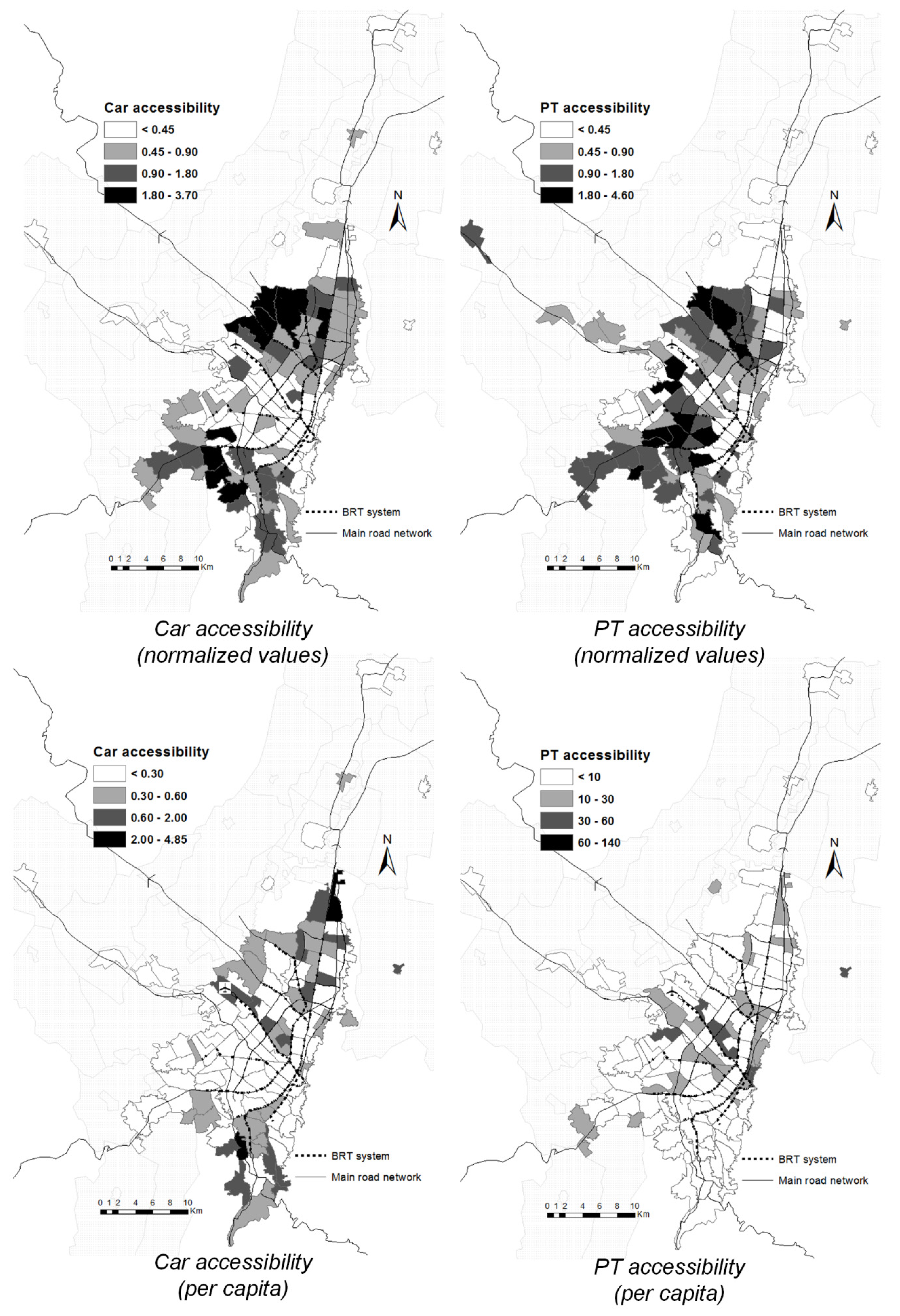
Second, in
Figure 6, normalized accessibility values suggest higher accessibility (via both private and public transport) in the areas with lower income in the southern part of the city and the middle-income areas in the northwest of Bogotá. The results were compared with the population in the different UPZs in order to compare the effective accessibility in different zones. As shown in the lower part of
Figure 6, per capita accessibility by private vehicle is higher in areas of the bottom 40%, despite income and motorization figures suggesting much lower access to this transport alternative in such zones. From a sustainability perspective, this suggests that the distribution of infrastructure and other opportunities for travel are biased towards private motorized vehicle use, not only requiring higher environmental costs, but also being inconsistent with the distribution of capabilities. The estimation of per capita accessibility allows for a comparable indicator of the number of potential opportunities accessible as a ratio of the potential demand for such opportunities. The higher the per capita accessibility, the higher the potential of an individual in each zone to realize valuable functionings. By contrast, there is higher accessibility to non-mandatory opportunities by public transport in more central and higher income areas, which are better located in relation to the distribution of opportunities presented in
Figure 2. These results contrast to the results found by other studies [
52,
53,
54], which usually find accessibility levels to be higher by car. Here, our results are consistent mainly because of two basic assumptions: using the car is much more expensive than public transport, because we are including the operation cost per km (which includes insurances, maintenance, parking and fuel), and also because the car ownership index for the bottom 40% of the population is, on average, 52 veh per 1000 inhabitants, while for top 10% of the population the index is 480 veh per 1000 inhabitants.
One of the main limitations of the estimations is that information for non-motorized travel is of a comparatively lower quality and scale than that for motorized travel, which constrains the estimation of non-motorized accessibility indices. However, public transport accessibility can be a good proxy for local accessibility indices, which may suggest higher access in the areas with lower travel expenditure via walking and cycling.
The results summarized in
Figure 6 suggest spatial inequalities in access to opportunities. As discussed earlier, the top 10% of the income distribution is used as the benchmark for equity analysis.
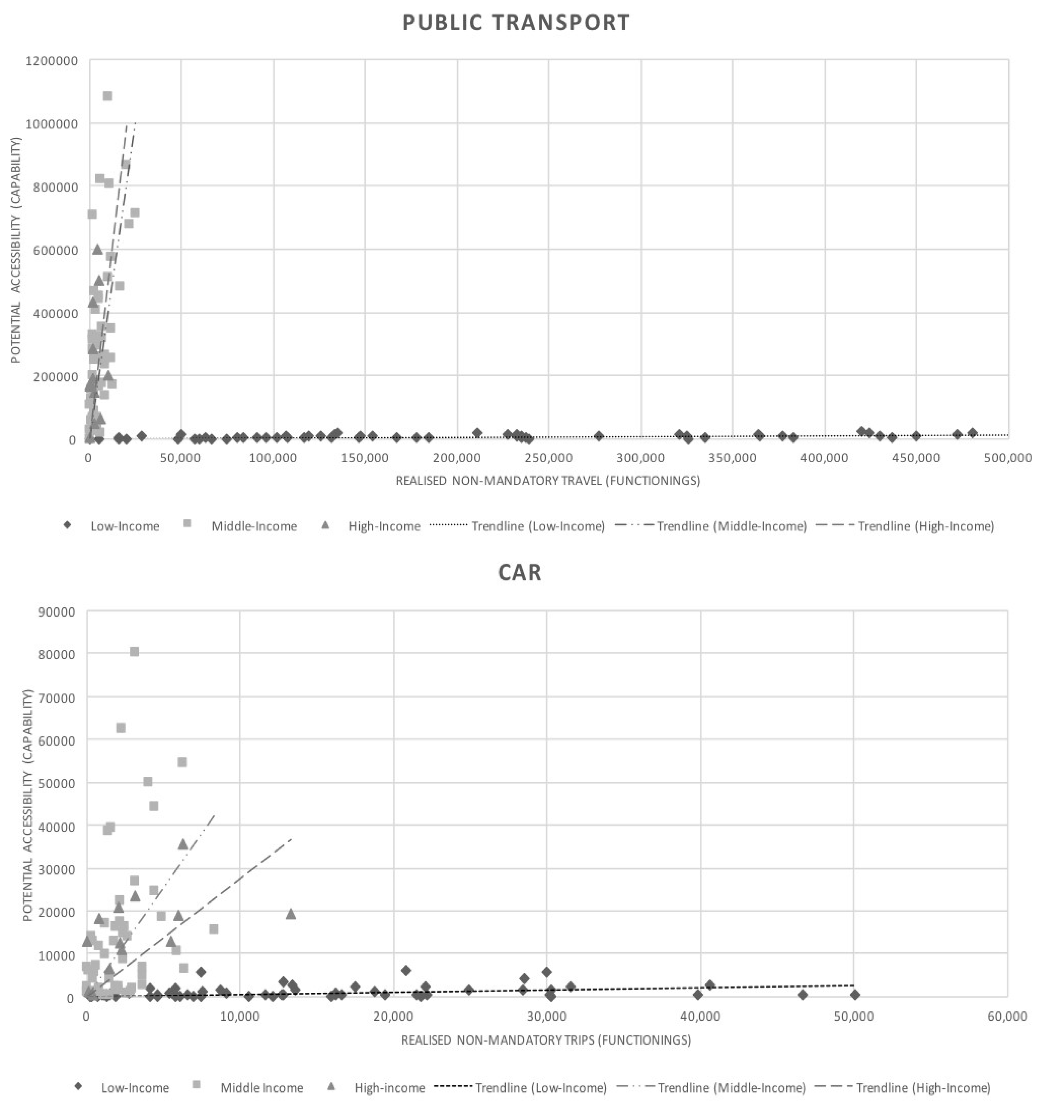
Figure 7 reflects empirically the conceptual links between accessibility, capabilities and sustainability. Capabilities, understood as the substantial freedoms of what people can potentially do and be, are more related to potential accessibility despite the methodological limitations for its estimation. Accessibility reflects the various constraints imposed by the availability of transport choices, the distribution of opportunities in the space and land uses, and the intrinsic limitations of the urban form of the BMR, its extension and topography. In this regard, understanding functionings as doings and beings, it can be argued that observed generation of non-mandatory trips from the HTS is a good reflection of what people are doing on the ground.
In this regard,
Figure 8 confronts the two guiding concepts from the CA for each zone in the BMR, showing explicitly the distance between capabilities and functionings. As shown, when comparing the actual travel and the potential accessibility by car and public transport for the study area classified by income groups (where high is the top 10% of earners, low is zones corresponding to the bottom 40% and middle is the zones within the remaining 50%), it is observed that low-income realized travel is much higher than its potential accessibility. The opposite is true for higher income groups. The trend lines in
Figure 8 show the distance between capabilities and functionings, which can be interpreted depending on the slope. If the trend line has a steeper slope, it suggests that the distance between potential accessibility and realized travel is shorter. Therefore, the flatter the trend, the farther is actual travel from potential accessibility, signifying additional cost, effort and negative environmental effects associated with securing access to essential opportunities.
These results reflect the marked differences in the structural conditions for accessibility in the BMR. It also supports findings in previous studies that low-income populations have to make additional efforts to access opportunities despite structural constraints for potential access [
20,
55]. When comparing zone-by-zone, findings from previous results become clearer: although top earners have a comparable accessibility to low-income groups, the first are a minority of the population while the second are the majority. The marked differences between the very steep high-income trend line and the almost flat low-income one suggest structural inequities in opportunities, which is the main moral concern of the CA.
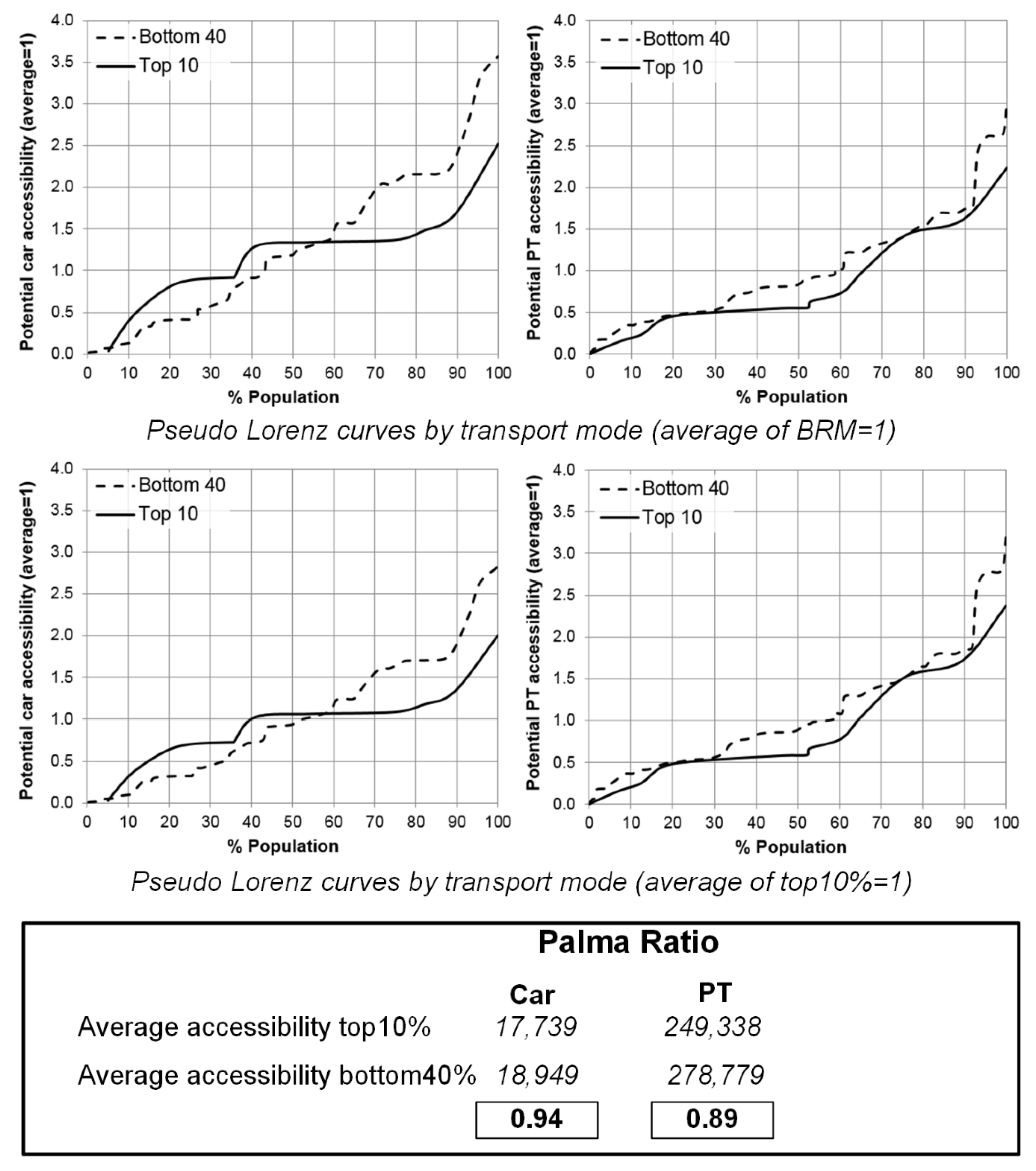
Figure 8 (top) shows the accessibility levels experience compared across the population. Here, accessibility levels are plotted against the percentile of the population in order to examine inequalities between income groups using a pseudo-Lorenz curve (vertical equity) [
1]. This shows that nearly 40% by car and 65% by public transport of both top earners and bottom quartile groups have a lower accessibility than the average, although the remaining 20% have a much higher accessibility in the lower income group. This is an interesting result, as it suggests that for a share of lower income population the car can be a relevant means of potentially securing access to non-mandatory activities.
The inequalities in opportunities discussed in
Section 2 and reflected by
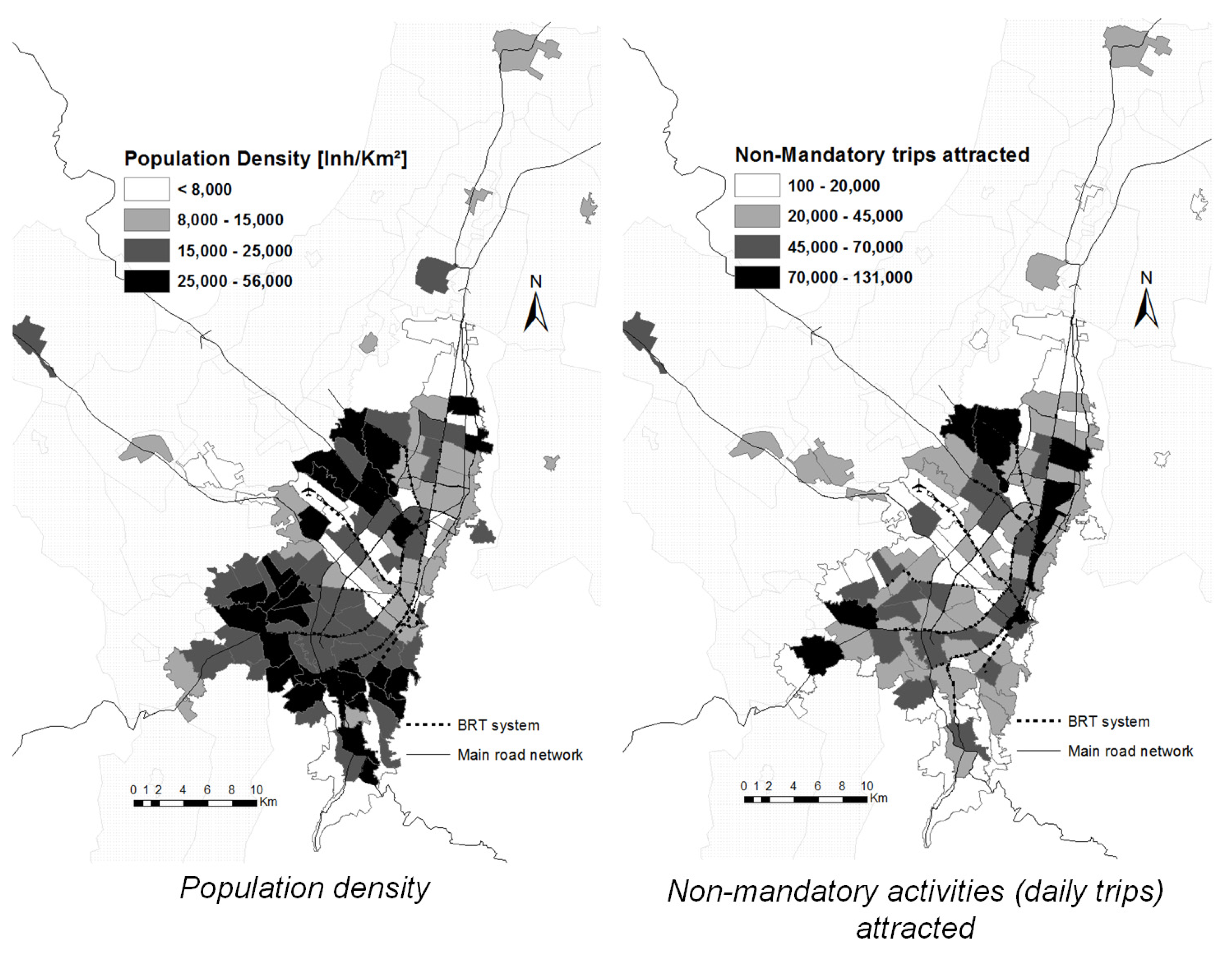
Figure 8 are further explored with the calculations of the Palma ratios and the curves. The curves of accessibility by public transport are much closer, suggesting similar distributions of accessibility, with even higher values in the low-income population. However, this only suggests that the richest 10% of the population has access to non-mandatory activities that rivals that of the bottom 40%. This may be explained by the distribution of opportunities for activities shown in
Figure 2, as well as a contribution of the public transport system routes, which increase the spatial reach of people in farther areas from the city center. This is reflected by the Palma ratio calculations, which return values close to 1 for both public transport and car. Although this could be interpreted as parity in accessibility, the reader should remember that the top decile of income represents a minority of the population of the BMR (6%) while the bottom 40% is more than half of the region’s population (56%), which was also reflected in the zone-by-zone comparison between potential and realized travel shown in
Figure 8. In other words, the richest people in the city have as much potential access to non-mandatory opportunities as the poorest half of the population combined. An analysis of sensibility of the Palma ratio suggests that comparisons between upper- and lower-income tiers (i.e., bottom 20% vs. top 20%) reveal higher accessibility of low-income populations.
5. Discussion
Results from the accessibility analysis reflect inequalities in the distribution of potential accessibility of non-mandatory opportunities. The information used for the calculations build on observed trips from Bogotá’s HTS in the face of heavy data constraints for examining potential trips and unmet travel needs. These data have been exploited in the past to look at mandatory travel, finding stark inequalities in access to employment driven by segregated land-use and differentiated distribution of opportunities and capabilities across the city (see [
1]), which ultimately limits peripheral and low-income groups from improving their economic well-being. We revisit the accessibility methodology recognizing the limitations of contexts such as Bogotá and propose proxies to analyze the influence of the distribution of capabilities and opportunities for individuals to realize relevant functionings beyond employment and education. Considering that the CA is more concerned about the satisfaction of basic capabilities and functionings, we set off to examine the structural constraints that may affect the transition between potential and realized travel for individuals in different zones of the city and the influence of social and geographical positions to transform capabilities and opportunities in access to relevant activities.
We hypothesized that the gap between capabilities and functionings of higher income populations—who are also better located in relation to the spatial distribution of opportunities—is narrower than the difference between what low-income people want to access and what they can.
Figure 8 finds large distances between what people in low-income groups can potentially access and what they actually do, while in higher-income groups this gap is narrower. This does not only carry implications for social equity and justice in transport, but also has larger distributional consequences in relation to the available travel mechanisms used for securing access to non-work and non-education opportunities. As shown in
Table 1 and later analyzed throughout
Section 4, lower-income groups make most non-mandatory travel via walking and cycling, reducing the overall environmental impact while increasing their well-being. However, zone-by-zone results suggest that while the capabilities of low-income zones may be low, their functionings (or realized travel) is much higher. This suggests a larger willingness to travel despite high impedance between origins and destinations, but also a higher generation of trips within the local area. The high intra-zonal and short-distance mobility of low-income groups compared to high-income groups is at odds with other results of the empirical analysis that show that when aggregating the potential accessibility of low- and high-income groups they are comparable. Building on this hypothesis, using higher-income populations as the benchmark for potential accessibility to non-mandatory opportunities, we suggest an implicit measure of inequity. This is supported using metrics such as the Palma ratio, which gives an indication of how inequitable the distribution of accessibility can be between the richest and poorest segments of the population.
These results reflect structural differences in the accessibility of leisure, health, and other relevant opportunities. Accessibility relates to the role of the land-use and transport systems in society, and their influence on the opportunity to participate in activities in different locations. Although the differences in accessibility for the selected deciles of the population in Bogotá do not differ significantly in absolute terms, the Palma ratios suggest that the top 10% richest inhabitants of the BMR access nearly as many opportunities as the bottom 40%.
Figure 8 shows how around 40% of the population in the city has a higher accessibility level than the average of the richest quartile, while 10% has less than 50% of the average non-mandatory accessibility level by car, and less than 20% by public transport.
An encouraging result in relation to such a distribution is that, unlike work and education opportunities, there seems to be a less decentralized structure for Bogotá’s health, leisure and social resources, and also that there is a higher generation of non-mandatory travel in low-income areas both by motorized and non-motorized modes. However, coverage of public transport still has not fully responded to the mobility needs of peripheral and lower-income areas of the city, restricting the structural freedoms and opportunities available for this segment of the population. The inverse distribution of public transport and car-based accessibility in relation to the zones with a higher proportion of users of each of these modes reflects how the infrastructure has been developed with objectives of efficiency and speed that benefit private mobility, even in lower income areas, while the public transport network has lagged behind in its ability to cover the outer areas of the city. This leads better-located and higher-income areas to experience higher levels of accessibility by public transport per capita despite having higher availability of alternatives for travel, whereas people with little or no access to a car would have a greater need for a private vehicle to increase their spatial reach and access more non-mandatory opportunities.
A limitation of this study that has been highlighted earlier is that the data used are not recent. Nonetheless, key findings of the research are still applicable in today’s context, as many of the structural conditions underpinning accessibility to opportunities and socio-spatial segregation have remained largely unchanged. Despite some socioeconomic and transport-related changes, such as increase in income and economic activities, as well as increased levels of motorization particularly of private motorcycles, which have taken place in recent years, the social and economic spatial distribution of the city and the locations of opportunities for work, study, leisure and social activities have seen little change [
56,
57], with recent evidence suggesting that the current urban structure has been consolidated.
6. Conclusions
The conceptual baseline of our research allows to measure the systematic inequalities between better-off and worse-off groups. This approach is linked with the CA, which suggests a significant influence of the surrounding environment on an individual’s ability to transform resources and opportunities into valuable functionings and suggests that accessibility plays a relevant role in enabling wellbeing. Such an influence of the environment, understood as the structural conditions of availability of transport choices, urban form, and spatial, economic and social distribution of cities, allows to bridge accessibility, capabilities and inequality. The theoretical discussions of the CA and its application to transport suggest that accessibility may hold the key to address equity and justice concerns in relation to urban mobility if we can interpret accessibility as a “combined capability” (see [
31]). This research is but an initial attempt at linking empirically the very rich theoretical discussions on the CA and the often-precarious evidence base and data resources for the analysis of potential and realized travel in cities of the Global South.
Our paper also addresses this challenge while dealing with the added layer of complexity of the analysis of non-commuting travel, which addresses opportunities beyond work and study that are considered as part of essential functionings and opportunities for having a life that holds meaning. Our approach attempts to translate in a simplified fashion the conceptual complexity of accessibility as a combined capability with aggregated measures of accessibility, which can at least partially link the role of structural conditions for mobility with transport inequalities. This is an important point of focus, as we discuss inequality in relation to transport and not the more complex definition of mobility, which involves a larger focus on individual characteristics, preferences and abilities. Although we recognize that there are limitations between the methodology and the conceptual framework of the CA, the analysis shown in this paper reflects a relevant influence of the land-use and transport component of accessibility, as well as of differences in income over the potential and realized capacity for travel of people in different zones of the BMR.
The analysis of non-work accessibility and the definition of transport inequality entail methodological challenges, such as the reinterpretation of the results of accessibility equations and the use of measures such as the Palma ratio. Non-mandatory travel has the characteristic of different times, frequencies and locations than work and education-related travel. The aggregated analysis of such opportunities allows researchers to identify the distribution of opportunities for activities that could not otherwise be pinpointed due to lack of data. These activities have different impedances than mandatory travel, given a more decentralized spatial distribution of opportunities. Future research is required in order to produce a more disaggregated analysis of non-mandatory travel by categories such as healthcare, social interactions and leisure. This carries important implications for urban transport policies and decision-making related to public transport. The methodology and findings highlighted in the paper can serve as inputs for the spatial and temporal redistribution of public transport supply that can increase accessibility to non-mandatory capabilities and functionings as well as the rethinking of fare mechanisms that can increase affordability and access during periods when low-income groups engage more with non-mandatory activities.
In the context of the CA, inequalities in functionings are influenced by heterogeneity in personal preferences, which places it as an unimportant moral concern from the perspective of the Capability Framework. However, the results from our analysis of non-mandatory travel suggest that lower income people have higher local functionings than higher-income groups and lower disaggregated capabilities, which would reflect structural inequities in the abilities to transform resources and opportunities into valuable functionings and points at the sacrifices that lower-income people make to actually access opportunities. This calls for attention to the spatial distribution of cities like Bogotá, and the role of public transport and other mobility infrastructures in closing the gaps in accessibility between social groups in urban areas. The higher potential accessibility by car in low-income areas using the normalized indices only reflects that disadvantaged populations in terms of distance to the economic centers and income could potentially access more opportunities if they had access to private vehicles, which they do not, also increasing the potential environmental cost for society, which renders this and other car-based travel, such as ride-hailing, unfeasible solutions at the required scale. Additionally, the lower-income areas that benefited in these same terms from public transport accessibility are almost generally within the catchment areas of the city’s BRT, which implies the system can potentially reduce the impedance of these zones to the main attractors of non-mandatory travel. This still reflects a need for targeted interventions to improve coverage in zones with lower capabilities by virtue of their potential accessibility. These results are but a first estimation of the structural conditions for accessing opportunities, and need to be confronted with individual characteristics, preferences and limitations to fully estimate differences in capabilities and functionings.
The income classification suggested by Palma is useful in the analysis of cities like Bogotá, enabling the detection of systemic inequalities in the spatial distribution of opportunities. The results of non-mandatory accessibility analysis reveal higher accessibility by private vehicle in the areas with lower income, whereas higher public transport values for non-mandatory activities are found where the mass transport system is currently operating. Future research should compare different equity indicators applicable to accessibility (such as the Gini index and the Palma ratio) and assess their applicability to other transport-relevant variables. Pseudo-Lorenz curves and the Palma ratio suggest that the top 10% income group in Bogotá has nearly the same accessibility level for non-mandatory activities as the bottom 40%. This reflects significant deficits in the potential ability of low-income residents of Bogotá to access opportunities other than work, thus limiting their quality of life (which can be further limited by other restrictions on their ability to carry out activities, such as purchasing power).
