Article

Sustainable Fruition of Cultural Heritage in Areas Affected by Rockfalls

Department of Biological, Geological and Environmental Sciences, University of Catania, Corso Italia 57, 95129 Catania, Italy
*
Author to whom correspondence should be addressed.
Sustainability 2020, 12(1), 296; https://doi.org/10.3390/su12010296
Submission received: 19 November 2019 / Revised: 23 December 2019 / Accepted: 23 December 2019 / Published: 30 December 2019
(This article belongs to the Section Tourism, Culture, and Heritage)

Abstract

:
This paper deals with the evaluation of rockfall risk in cultural heritage, in the frame of a quick protocol for a preliminary zonation, to ensure the safe management and sustainable fruition of the sites. Several historical complexes in mountainous areas are indeed threatened by rock slope instability, and rockfalls can be counted among the main causes of fatality. In such a complex, a rockfall risk zonation would represent a useful management tool for both the choice of specific safe tourist paths, but also for the proper employment of economic resources allocated for mitigation measures. Nevertheless, the management of cultural heritage lacks such plans and tourists are often exposed to risks, while funds are often employed without a specific priority. In this paper, a quick procedure was tested at the historical complex of Taormina (southern Italy), which hosts numerous tourist spots often affected by rockfalls. The Saracen castle, for example, is currently closed to the public due to the rockfalls that repeatedly affected the entrance road, while Castelmola village, counted among one of the most beautiful Italian villages, stands on the top of a cliff affected by frequent rockfalls involving the only access road. The approach is composed of several steps and requires a heavy site characterization in terms of historical records and geostructural setting. The risk assessment procedure was chosen among the semiquantitative ones available in literature, and the final assessed risk was represented on a thematic map to provide a tool which could be used as a base for the planning of final remedial works.

1. Introduction

The Convention for the Protection of Cultural Property in the Event of Armed Conflict was signed at The Hague (Netherlands) in 1954, after the massive destruction of cultural heritage during the Second World War. It represents the global commitment of world countries to take all possible steps to protect cultural properties in case of future wars. Such a milestone regards immovable and movable cultural heritage including, among others, monuments of architecture, art or history, and archaeological sites. Nevertheless, in periods of peace, there are other threats impending over the cultural heritage and arising from natural events. With specific reference to territories hosting examples of cultural heritage, in terms of monuments, religious/tourist sites or entire towns, the main risk factors include a wide spectrum of hazards, from seismic to climatic. In this view, the cultural tourism sector in general needs protection and requires an ensured sustainability, intended as a balance between society, the environment, and the economy [1,2]. Every year, natural disasters cause loss of life and damage to property, including heritage sites, as well as damage to the environment [3,4,5]. The most remarkable natural events usually threatening the fruition of such areas are earthquakes (e.g., [6,7,8]) and landslides (e.g., [9,10,11,12,13]). These two phenomena can be often associated, as a seismic event can be considered a trigger of landslide movements [14,15,16,17,18,19]. In this scenario, rockfalls represent a sudden, hazardous event threatening several mountain areas worldwide [20,21,22,23,24] usually driven by local geological, geomorphological and climatic specific conditions. When these phenomena threaten the possibility of a safe fruition of cultural heritage, the problem gains high relevance due to the potential involvement of a great number of people. Natural disasters affect both the immovable heritage elements such as monuments, archaeological sites and historic urban areas, and the movable components, e.g., museum collections and heritage objects representing great significance to the local community. This aspect falls within the wide topic of the preventive conservation of cultural heritage, involving also the environmental management [25]. Disaster risk management involves mitigation measures and adaptation strategies aimed at reducing the risks to movable and immovable heritage components, by taking into account their economic and heritage values. In particular, risk arising from rockfalls is not only limited to the site itself, where the safety and protection of visitors must be ensured, but also to the access infrastructure where visitors converge. For safe management of the sites, a localization of the areas at risk is crucial, along with the assignment of a priority for risk remediation measures to perform. Such zonation would indeed represent a useful tool for the management of the site, in the perspective of the proper destination of allocated economic resources. The procedure should be quick and be based on a critical evaluation of the slope stability, even according to data already available in literature or local offices, and should provide a risk zonation highlighting the areas that must be studied in-depth for a definitive securing. In the scientific literature, there are examples of rockfall risk management (e.g., [26,27]), which should always be based on a preliminary zonation of the territory.
In this paper, a rockfall risk assessment-based procedure is tested on a rockfall-affected area to achieve a zonation of rockfall risk in a wide historical complex. The risk assessment method was chosen among those available in literature [28] and is a semiquantitative rating system, developed on an empirical basis, for natural rock slopes. The area chosen for this application is located in northeastern Sicily and involves the Taormina complex. This region has been suffering rockfall threats for decades due to its particular geological and tectonic setting. The historical complex taken into account herein is composed of the Saracen Castle of Taormina, located on the top of a carbonate promontory, which is closed to the fruition due to the rockfalls that repeatedly affected the entrance road; part of the Taormina city center, threatened by rockfalls originating from the Monte Tauro cliff, which cross a pedestrian path connecting the center to the castle; and Castelmola village, one of the most beautiful Italian villages [29] standing on the top of a carbonate cliff affected by frequent rockfalls involving the only access road. In this paper, after the analysis of literature and historical data available on these locations, the Rockfall Risk Rating System [28] was applied to each sector to compile a thematic map on the priority of remedial measures, so as to provide an example of useful output for the management of the sustainable fruition of cultural heritage in areas affected by rockfalls.

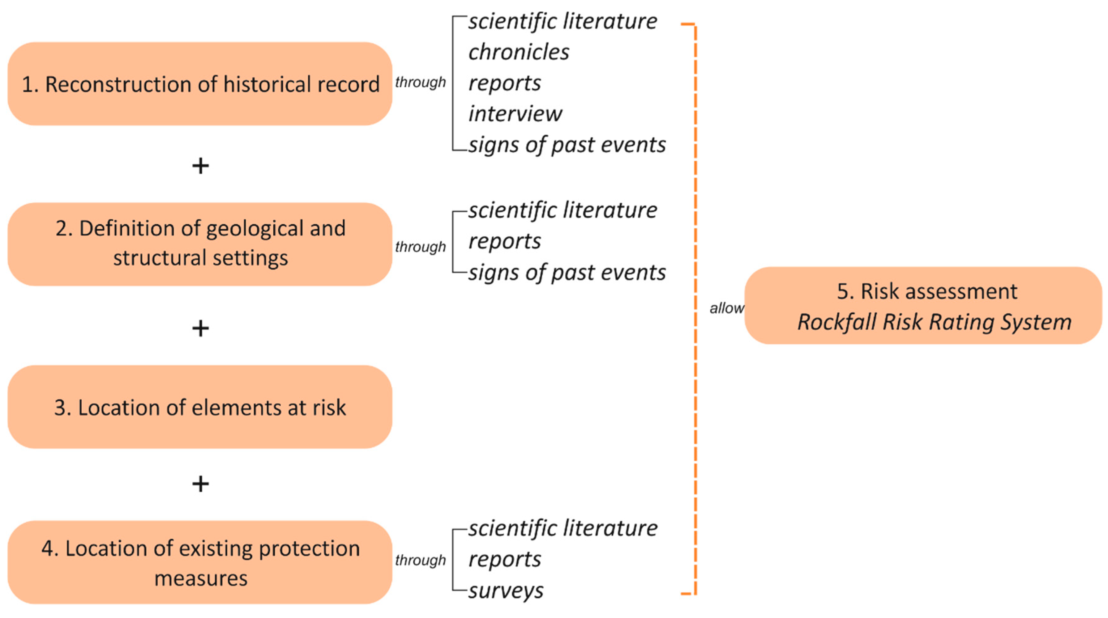
2. Methodological Approach

The aim of this paper is to test a quick protocol for the assessment of rockfall risk along natural slopes to achieve a preliminary zonation in cultural heritage sites for their safe management and sustainable fruition.
The methodological approach followed herein (Figure 1) starts with information gathering on the rockfalls that affected the area in the past. The historical record is a key source of data and provides guidance as to what could happen in the case of further events. Any kind of source is welcomed, from scientific/technical literature to local interviews, because usually only the greatest events, in terms of rock volume and magnitude, are documented by local chronicles. The observation of marks left by previous rockfalls on the ground could be helpful, although such signals are usually soon erased by vegetation and time. This preliminary activity lays the foundations for the identification of the past source areas and the location of potentially unstable sectors of the rock masses. Once we achieved such knowledge, the following step was to locate the elements at risk, i.e., all assets occurring in an area that could be adversely affected by a rockfall hazard [30]. In this specific case, the term “asset” refers to people (e.g., visitors stopping at a particular spot, visitors passing along a path), structures and infrastructures, properties (e.g., vehicles, items within houses, domesticated animals), activities (e.g., commerce, transportation, entertainment) and environment (flora, fauna, environmental quality and amenity) [30]. Such a wide spectrum of assets proves the wide spectrum of elements at risk that should be considered in the case of tourist areas, moving the viewpoint from the consideration that risk arises only if a rockfall could hit a person, to the fact that risk exists even if a small boulder brings damage to a structure. Once such key information is collected, the location of protection measures present along the slopes must be carried out, as in a risk assessment which can act in favor of a risk reduction (Figure 1).
The risk assessment can be carried out according to one of the numerous approaches found in literature (e.g., [31] and reference therein), considering that this activity should lead to a preliminary zonation on a general scale of the site, which in turn will be the starting point for specific remedial measures design. In this study, we have chosen the semi quantitative Rockfall Risk Rating System (RRRS) proposed by [28] due to its suitability for natural and man-made slopes. It defines twenty rating parameters, grouped into four categories according to the hazard and consequences, with a different weight in the final risk assessment (Table 1). The first category of hazard A involves parameters depending on the slope geometry and the detachment area. Category B refers to the geological setting and rock mass geomechanical conditions, while category C is about the potential triggering factors and drainage condition. Finally, category D holds parameters on the presence of mitigation measures, elements at risk and the accessibility of the slope (Table 1). In this specific frame, we suggest herein a possibility to evaluate the benefit arising from the presence of mitigation measures, by providing the point 17b (presence of mitigation measures) as an alternative to the original 17 (width of catchment zone). In this case, we can discriminate the absence of mitigation measures (maximum rate, as for the absence of catchment zone), the presence of localized and preliminary measures, the presence of diffuse permanent mitigation measures but with some still unprotected slope sectors, and the presence of an efficient stabilization series of measures.
Each parameter is rated with a score between 10 and 100, where 10 represents the most favorable condition and 100 the most adverse one. Such scores have to be weighted according to each category weight, defined by [28] based on reasonable geoengineering judgments, and the final risk score is the sum of such values. According to the resulting weighted score, which would range between 1 and 100, 5 risk classes are defined, from very low (<20) to very high (81–100) (Table 2). This allows a quick rating of the studied rock masses, thus a prioritization of remedial works.

3. The Historical Complex of Taormina

Tauromenium was founded by Andromacus under the tyranny of Dionysius in 392BC. Built on Monte Tauro, this village and its strategic location became a favorite holiday spot for Patricians and Senators of the Romans in 212BC, thus giving rise to Taormina’s long history as a tourist resort. After the fall of the Roman Empire, the domination was by Byzantines and then by the Arabs in 962. They changed the name to Almoezia and introduced new agricultural practices, medicine and mathematics. In 1079, the arrival of Normans allowed Taormina to maintain its prosperous condition, from both the cultural and the economical points of view. The different conquerors left a mark in the territory, still found in the numerous monuments available for the international tourist fruition, such as the Greek-Roman theatre, the Saracen castle, tens of medieval streets, the 13th Century Cathedral and Baroque fountain, the probable ancient acropolis Castelmola and its castle.
Although on the one hand, the territory hosting such cultural heritage allowed its historical development thanks to the strategic setting, i.e., steep cliffs dominating the Ionian coastline, on the other hand, it is the main cause of risk arising from natural events. In fact, this territory has been suffering a relevant rockfall problem for decades. The geological and tectonic setting are mainly responsible to a poor-fair geomechanical quality of the rock masses (e.g., [32,33,34,35]), which often gives rise to rock volume detachments, especially after heavy rainfalls. The most critical detachment points are located along carbonate rock masses belonging to the Liassic greyish-white limestones and dolostones formation described by [36]. This represents the sedimentary cover of a metamorphic terrain, which is the basement of the Peloritani Mountains, a regional nappe-pile edifice composed by distinct tectonic slices. Most of the rockfalls have never been documented, although [37] provided a list of the most remarkable ones, which is herein integrated with the most recent ones (Table 3). This analysis highlights that in the latest years there is at least one event per year causing safety problems, thus deserving a critical attention. The main elements at risk of the area are represented by infrastructures connecting Taormina to Castelmola (both pedestrian and vehicular paths) (SP-10), the main square of Castelmola (MS-viewpoint on Taormina) and the pedestrian pathway (PPW) to reach the Taormina castle from the city center. This condition represents a threat to the site fruition, especially in periods with a high tourist rate (Figure 2).

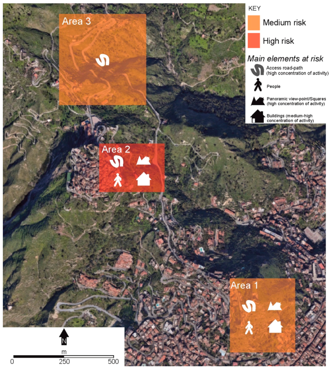
4. Definition of the Study Areas

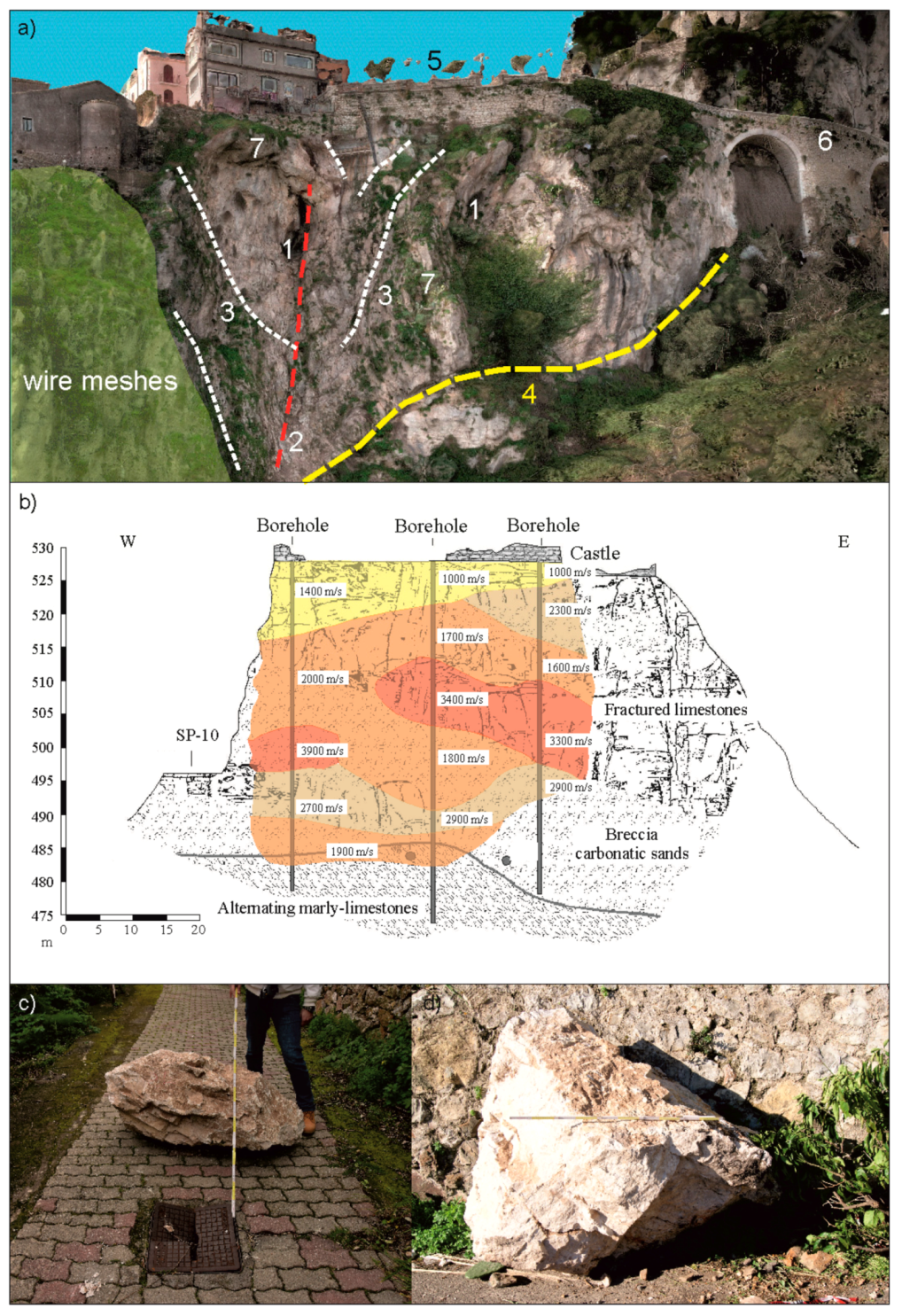
4.1. Area 1: Monte Tauro Cliff and the Saracen Castle

The Saracen Castle stands on the top of Monte Tauro, a 390 m-high carbonate cliff, where the remains of this fortification are represented by the imposing tower, the walls, a cistern and an underground corridor (Figure 3a). Today, the castle is closed to the public, although tens of tourists daily reach the top of Monte Tauro to see the wonder of this ancient historic monument and the magnificent panorama from the summit. To reach the monument, a pedestrian path (PPW) starts from the lower city center of Taormina and climbs steep rock slopes through a series of staircases with twelve stops at the Stations of the Cross, making this pathway relevant even from the religious point of view (Figure 3b). This infrastructure shows widespread damage, both in the pavement and at some segments of the banister, brought by falling rock boulders detached from the upper carbonate cliff. Some of these blocks, with a volume of about 0.15 m3 can still be found either on the pathway or at its side (Figure 3b,c), and signs of recent detachments can be seen at the sub-vertical rock face, along with evidence of unstable blocks (Figure 3d).
Starting from these field observations, with the aim of applying the RRRS to this slope, the collection of data on the historical rockfalls was carried out by local interviews and scientific literature. Mineo et al. [35] presented a preliminary hazard analysis of the cliff, highlighting that PPW mainly falls within a high-to-moderate hazard sector according to the application of a hazard matrix. Nevertheless, the final PPW segment, close to the entrance of the castle, was not taken into account by the above mentioned study, although local people told us about frequent rockfalls involving smaller boulders (about 0.05 m3), which represent a threat for the passing visitors (Figure 3d). Signs of bolt reinforcement are visible at the highest portion of the cliff (Figure 4a) below the castle, and a rockfall barrier has been surveyed behind a private house.
According to this setting and in the perspective of the aim of this paper, this area can be divided into two sectors:
  • Sector 1a: Enclosing the highest portion of PPW, in the proximity of the entrance of the castle, where remedial measures have never been performed and where loose rocks were surveyed (Figure 4a)
  • Sector 1b: Enclosing the downstream portion of PPW, which is still affected by boulders detaching from the northwestern cliff (Figure 4a)
The geostructural setting of the rock mass was studied by Mineo et al. [35], who performed rock mass surveys highlighting that the most frequent unstable kinematic pattern is the planar sliding, followed by toppling and some wedge configurations (Figure 4b). The geomechanical quality of the rock, assessed by the Rock Mass Rating system (RMR, [47]) was assessed as “fair rock” (RMR between 41 and 60), and some simulated trajectory of blocks underline that PPW is affected by block bounces at several spots (Figure 4c).
For the risk assessment proposed herein, the information was treated with the specific aim to assign the scores according to Table 1. In particular, the cliff face is affected by a sub-vertical geometry and rockfalls mainly arise from its top, representing the worst scenario considered in the RRRS. Total height is about 30 m at area 1a, while it is >60 m at area 1b. On the one hand, the presence of PPW climbing over the slopes enhances the block bouncing, on the other, vegetation plays a braking role. Joints show a medium to high persistence along with moderate apertures, sometimes filled with soft material, and index of water circulation within the fracture network (Figure 4d). Joint Roughness Coefficient JCS is, on average, 50 MPa, while the intact rock strength shows an average value of 80 MPa [48,49]. The block volume can be herein estimated according to the past rockfalls and it is on average <1 m3; while rainfall condition is seasonal, with rains mainly occurring in winter and spring, although summer heavy rains usually characterize the local climate. Rock mass permeability is high thanks to the fracture net and karst features which are widespread over the cliff [50]. With reference to presence of stabilization measures, there are still several sectors of the slope requiring mitigation works, therefore the rate considered herein for this category is 60.
The final rating assigns the score of 52.7 and 48.65 for areas 1a and 1b, respectively. According to the RRRS classification system, both areas fall within class III (medium risk), where light measures (such as bolts, nets, removal of unstable blocks, simple light fences) are suggested. The difference between the two scores is due to the presence of a denser vegetation at area 1b, which plays a breaking action on falling boulders, the greater apertures of discontinuities at area 1a, and the absence of mitigation measures at area 1a. In this latter case, although at area 1b the highest portion of the southern cliff was secured by active measures, the eastern cliff (source area of the latest rockfalls) is still unprotected.

4.2. Area 2: Castelmola Village

Chosen to be part of the “Most Beautiful Italian Villages”, Castelmola is a pre-Hellenic settlement probably serving as Taormina’s acropolis in historical time. It stands on the top of a carbonate cliff, with a rugged morphology, resulting from dynamic geological and geomorphological processes. The village surrounds the ruin of a Norman castle, perched on the highest spot of the cliff, and can be reached by the only SP-10 access road passing through the close Taormina (Figure 2). The historical research performed herein to reconstruct the rockfall activity of the site returned key information: in the 1990s, the cliff underwent an in-depth geognostic campaign, both through direct and seismic surveys, in the frame of a partial stabilization project [39]. Five main discontinuity systems were recognized at the rock mass, giving rise to the rock fragmentation into unstable blocks (volumes up to 0.75 m3) and the poor geomechanical quality of the rock was assessed by Rock Quality Designation (RQD) [51] with values below 55%. Data available in the scientific literature highlight that the main cliff, where the city square (MS) is one of the main tourist spots located on its top (Figure 5a), hosts unstable rock volumes ranging from 0.5 to 432 m3. The most recurrent kinematic feature is represented by wedges, formed by the intersection of the most persistent discontinuity systems (Figure 5a), according to the geomechanical configuration of the area [52]. Variously fractured rock material is present within the wedges and represents the mobilizable rock volume in case of failure. A stability analysis, performed according to the limit equilibrium method, returned safety factors ranging between 0.90 and 1.30 in static conditions and <1.00 under pseudo-static conditions [41]. Due to the high hazard arising from this setting, a rockfall barrier was built in 2006 to protect a group of houses and, more recently, part of the cliff was secured with wire meshes. Seismic Down-Hole surveys were carried out for the measurement of P and S wave velocities. Their cross-correlation allowed mapping portions of the rock mass with different geomechanical features (Figure 5b). Low velocity areas (P-wave velocity = 1000–2000 m/s) were found at both the top and the base of the cliff, indicating the presence of loose and intensely fractured rock, while higher velocities (P-wave velocity >3000 m/s) occurred in the central cliff portion [39].
Although some remediation works were performed in the latest years, the northeastern portion of the cliff, below the city square, is still unsecured and shows critical signs of instability. All the latest events arise from this rock mass, with volumes up to 5 m3. The latest remarkable event occurred in 2019, when blocks reached a downstream bus stop and the SP-10 access road, leading to its temporary closure (Figure 5c,d). After this event, urgent remedial works were performed to build a further barrier to protect the road.
According to such retrieved data, the RRRS was applied to this rock mass sector considering a sub-vertical cliff, with a release area located along its upper half, where no protections are present. Rock mass surveys highlighted the presence of karstic features along the slope. More specifically, the presence of a great karst cave, which developed along a fault plane, is detectable by the naked eye. This is 8.5 m high and 5.5 m large, testifying the presence of water circulation in the subsoil. Finally, the presence of sparse preliminary measures was considered along with the high-frequent human presence.
The final rating allows classifying this as a high-risk area, with a 64.8 final score (Table 4), where the combination of active and passive protection measures is suggested. Here, the presence of wide karst caves in an unprotected cliff makes this spot a relevant threat for the fruition of the site, both at MS, where retreat phenomena could lead to the square collapse, and at the access routes (both pedestrian and SP-10).

4.3. Area 4: Transit Route for Access and Fruition

The two main villages of Taormina tourist complex are connected by a single 6 km-long road (SP-10), which crosses steep slopes affected by an intense degree of fracturing (Figure 6a). This is one of the main targets for boulders falling along the slopes and the risk related to its involvement in rockfalls cannot be neglected. In fact, its closure for block invasion, although temporary, leads to a series of disservices such as the isolation of the village, which cannot be reached both by local inhabitants and by rescue in case of emergency. Furthermore, the traffic units traveling the road are the main elements at risk, along with a rate of pedestrian tourists. This infrastructure has already been taken into account for risk assessment purposes by [32,37], who classified this road as a high-risk route according to some semiquantitative and quantitative scientific procedures. In this paper, since the road is part of the tourist complex and it is the only tourist available path, we decided to include its northernmost sector (the one bordered by high carbonate dolostone and limestone cliffs) among the key areas of the Taormina complex and to apply the methodological approach of RRRS. According to [32], the structural setting of dolostones is characterized by 4–5 intersecting discontinuity systems (Figure 6b), with spacing ranging between 2 and 60 cm and openings from 0.1 to >5 mm. Fractures are generally filled with sand or calcite and show smooth or undulated surfaces, with a joint roughness coefficient (JRC) [53] ranging from 2 to 12. Analogously, limestones are crossed by four discontinuity systems, with apertures often >5 mm and JRC between 2 and 12. No considerable karst features have been surveyed in the outcrops of the study area. Slope height is between 30 and >60 m and the detachment zone is located at different altitudes. According to [37], the average block volume is 0.13 m3 and there are some sectors of the slope already partially secured with wire meshes (Figure 6). Furthermore, tectonic structures cross this road segment, enhancing the weakness of the already poor rock masses (Figure 6a).
The final assigned score is 51.75, corresponding to a medium risk area (Table 4). Despite the closeness with area 2, this mountain sector is characterized by a lower angle of slopes with a smoother morphology, along with a smaller block volume and the absence of karst features, resulting in a slightly lower final score.

5. Discussion and Conclusions

Results achieved in this study can be commented according to two aspects. The first one regards the local significance of outcomes, which could be employed by authorities as a guideline to commission in-depth studies aimed at the final securing of the areas. The second aspect is the scientific interest that the international community may take from this paper.
Starting from the first aspect, results show that all the examined areas are affected by a medium-to-high risk level, arising from unstable rock masses, which should undergo active and passive remedial measures. This would ensure a safe fruition of the Taormina historical complex, which is indeed one of the most known Italian tourist destinations. In particular, area 1, where the historical Saracen Castle of Taormina lays perched on the top of a carbonate cliff, results showed it was affected by a medium risk level due to the poor geomechanical quality of the rock and the presence of loose rock material impending over the pedestrian access pathway. Here, several rockfalls occurred and damaged this infrastructure, despite the presence of some localized active remedial measures (Figure 4). Area 2, where the ancient acropolis of Taormina is now one of the “most beautiful Italian villages” [29] results showed that it was affected by a high rockfall risk due to the relevant height of the source zone, the presence of karst features and the unfavorable kinematic condition of discontinuities (Figure 5). Finally, area 3, enclosing the northernmost segment of the only connection route between the previous areas, is affected by a medium risk level threatening the traffic units passing along the road (Figure 6).
Achieved outcomes highlight that risk arising from rockfalls is an aspect that cannot be underestimated when public safety is involved. Although the rockfall modelling is a complex activity, resulting from specific studies and surveys, in this paper we have presented a quick, preliminary procedure that can be applied to tourist sites for the evaluation of a risk level, in the perspective of a prioritization of remedial works. The applied system was chosen among the semi-quantitative ones available in literature and is suitable for natural rock slopes. In particular, the Rockfall Risk Rating System [28] applied herein proved a suitable tool for a preliminary risk zonation according to 20 parameters involving the slope geometry, the geostructural condition and the presence of elements at risk. In this specific frame, the reconstruction of a historical record on previous rockfalls is a key activity that can be performed by collecting data available in local chronicles, literature, and technical reports. Furthermore, if data on the geostructural/kinematic setting of the rock mass are already present, these can be used as preliminary information ensuring an expedite risk assessment. Alternatively, rock mass surveys should be performed to achieve a knowledge for the application of RRRS. Among the considered parameters, the impact on elements at risk holds the highest weight, followed by the presence of mitigation measures. These parameters are crucial, considering that this procedure is aimed at an evaluation of risk at cultural heritage sites. Nevertheless, there is a certain rate of subjectivity in such an evaluation, which, on the one hand, ensures a sort of flexibility of the methodology, which can be adapted to multiple cases, but on the other hand, can lead to an under-/over-estimation of the final score. In fact, if, for example, mitigation measures are present, the risk assessment must take into account the distribution of such structures and their efficiency, even from a preliminary evaluation, in order to highlight the contribution of rockfalls from unprotected sectors.
The final outcomes can be summarized in a thematic map, showing a different color according to the risk zonation and the main elements at risk (Figure 7), which could be used by the local administrators in the perspective of ensuring a sustainable fruition of the site. The whole procedure is quick, if historical and technical data are easily available, and does not require specific economic investments. This makes it suitable for a wide spectrum of cultural heritage in areas affected by rockfalls worldwide, where the need of an instrument that would lay the foundation for the beginning of a final securing is paramount for the sustainable fruition of the goods.
Outcomes achievable by this procedure can represent a useful instrument aimed at claiming funding to pursue the goal, although this would require in-depth studies. In this latter case, the parameters of likelihood and consequence deserve a specific attention, even in a quantitative way, as well as the geotechnical characterization of the slope for a suitable design of mitigation measures. In the specific case of rockfalls, the likelihood can be taken into account by the estimation of the probability of occurrence, based on field data and rock parameters. This is directly related to the slope stability assessment and to the estimation of the factor of safety. On the other hand, consequences arise from the specific elements at risk that are involved, and on the probability that a falling block can intercept either a passing vehicle, or a building, or a person, for example. Such considerations will depend on the trajectory modeling of rockfalls and on probabilistic calculations based on field data, which represent the next steps for the in-depth characterization of the problem aiming at a final remediation.

Author Contributions

Both authors contributed equally to this research. All authors have read and agreed to the published version of the manuscript.

Funding

This research was funded by Department of Biological, Geological and Environmental Sciences, University of Catania, Fund: Finanziamento delle Attività Base di Ricerca, granted to Giovanna Pappalardo.

Conflicts of Interest

The authors declare no conflict of interest.

References

  1. Thomas, B.; Thomas, S.; Powell, L. The Development of Key Characteristics of Welsh Island Cultural Identity and Sustainable Tourism in Wales. Sci. Cult. 2017, 3, 23–39. [Google Scholar] [CrossRef]
  2. Liritzis, I.; Korka, E. Archaeometry’s Role in Cultural Heritage Sustainability and Development. Sustainability 2019, 11, 1972. [Google Scholar] [CrossRef] [Green Version]
  3. Spennemann, D.H.R. Conservation management and mitigation of the impact of tropical cyclones on archaeological sites. In Disaster Management Programs for Historic Sites; Dirk, H., Spennemann, R., Look, W.D., Eds.; Association for Preservation Technology (Western Chapter) and The Johnstone Centre, CharlesSturt University: San Francisco, CA, USA; Albury-Wodonga, Australia, 1998; pp. 113–132. [Google Scholar]
  4. Spennemann, D.H.R. Cultural heritage conservation during emergency management: Luxury or necessity? Intern. J. Public Administr. 1999, 22, 745–804. [Google Scholar] [CrossRef]
  5. Taboroff, J. Cultural Heritage and Natural Disasters: Incentives for Risk Management and Mitigation. In Managing Disaster Risk in Emerging Economies; Kreimer, A., Arnold, M., Eds.; Series No. 2; Disaster Risk Management; World Bank: Washington, DC, USA, 2000; pp. 71–79. [Google Scholar]
  6. Parisi, F.; Augenti, N. Earthquake damages to cultural heritage constructions and simplified assessment of artworks. Eng. Fail. Anal. 2013, 34, 735–760. [Google Scholar] [CrossRef]
  7. Pappalardo, G.; Mineo, S.; Monaco, C. Geotechnical characterization of limestones employed for the reconstruction of a UNESCO world heritage Baroque monument in southeastern Sicily (Italy). Eng. Geol. 2016, 212, 86–97. [Google Scholar] [CrossRef]
  8. Clementi, F.; Quagliarini, E.; Monni, F.; Giordano, E.; Lenci, S. Cultural Heritage and Earthquake: The Case Study of “Santa Maria Della Carità” in Ascoli Piceno. Open Civ. Eng. J. 2017, 11, 1079–1105. [Google Scholar] [CrossRef]
  9. Canuti, P.; Margottini, C.; Fanti, R.; Bromhead, E.N. Cultural Heritage and Landslides: Research for Risk Prevention and Conservation. In Landslides—Disaster Risk Reduction; Sassa, K., Canuti, P., Eds.; Springer: Berlin, Germany, 2009; pp. 401–433. [Google Scholar] [CrossRef]
  10. Roberts, N. Culture and landslide risk in the Central Andes of Bolivia and Peru. Stud. Univ. Babeş Bolyai Geol. 2009, 54, 55–59. [Google Scholar] [CrossRef] [Green Version]
  11. Tarragüel, A.A.; Krol, B.; van Westen, C. Analysing the possible impact of landslides and avalanches on cultural heritage in Upper Svaneti, Georgia. J. Cult. Herit. 2012, 13, 453–461. [Google Scholar] [CrossRef]
  12. Pappalardo, G.; Imposa, S.; Mineo, S.; Grassi, S. Evaluation of the stability of a rock cliff by means of geophysical and geomechanical surveys in a cultural heritage site (south-eastern Sicily). Ital. J. Geosci. 2016, 135, 308–323. [Google Scholar] [CrossRef]
  13. Pappalardo, G.; Imposa, S.; Barbano, M.S.; Grassi, S.; Mineo, S. Study of landslides at the archaeological site of Abakainon necropolis (NE Sicily) by geomorphological and geophysical investigations. Landslides 2018, 15, 1279–1297. [Google Scholar] [CrossRef]
  14. Chen, X.L.; Zhou, Q.; Ran, H.; Dong, R. Earthquake-triggered landslides in southwest China. Nat. Hazards Earth Syst. Sci. 2012, 12, 351–363. [Google Scholar] [CrossRef] [Green Version]
  15. Barbano, M.S.; Pappalardo, G.; Pirrotta, C.; Mineo, S. Landslide triggers along volcanic rock slopes in eastern Sicily (Italy). Nat. Hazards 2014, 73, 1587–1607. [Google Scholar] [CrossRef]
  16. Romeo, S.; Di Matteo, L.; Melelli, L.; Cencetti, C.; Dragoni, W.; Fredduzzi, A. Seismic-induced rockfalls and landslide dam following the October 30, 2016 earthquake in Central Italy. Landslides 2017, 14, 1457–1465. [Google Scholar] [CrossRef]
  17. Wang, T.; Wu, S.R.; Shi, J.S.; Xin, P.; Wu, L.Z. Assessment of the effects of historical strong earthquakes on large-scale landslide groupings in the Wei River midstream. Eng. Geol. 2018, 235, 11–19. [Google Scholar] [CrossRef]
  18. Aimaiti, J.; Liu, W.; Yamazaki, F.; Maruyama, Y. Earthquake-Induced Landslide Mapping for the 2018 Hokkaido Eastern Iburi Earthquake Using PALSAR-2 Data. Remote Sens. 2019, 11, 2351. [Google Scholar] [CrossRef] [Green Version]
  19. Meena, S.R.; Piralilou, S.T. Comparison of Earthquake-Triggered Landslide Inventories: A Case Study of the 2015 Gorkha Earthquake, Nepal. Geosciences 2019, 9, 437. [Google Scholar] [CrossRef] [Green Version]
  20. Chau, K.T.; Wong, R.H.C.; Liu, J.; Lee, C.F. Rockfall Hazard Analysis for Hong Kong Based on Rockfall Inventory. Rock Mech. Rock Eng. 2003, 36, 383–408. [Google Scholar] [CrossRef]
  21. Dorren, L.K.A.; Seijmonsbergen, A.C. Comparison of three GIS-based models for predicting rockfall runout zones at a regional scale. Geomorphology 2003, 56, 49–64. [Google Scholar] [CrossRef]
  22. Guzzetti, F.; Stark, C.P.; Salvati, P. Evaluation of flood and landslide risk to the population of Italy. Environ. Manag. 2005, 36, 15–36. [Google Scholar] [CrossRef]
  23. Mineo, S.; Pappalardo, G.; Rapisarda, F.; Cubito, A.; Di Maria, G. Integrated geostructural, seismic and infrared thermography surveys for the study of an unstable rock slope in the Peloritani Chain (NE Sicily). Eng. Geol. 2015, 195, 225–235. [Google Scholar] [CrossRef]
  24. Mavrouli, O.; Giannopoulos, P.G.; Carbonell, J.M.; Syrmakezis, C. Damage analysis of masonry structures subjected to rockfalls. Landslides 2017, 14, 891–904. [Google Scholar] [CrossRef]
  25. Lucchi, E. Review of preventive conservation in museum buildings. J. Cult. Herit. 2018, 29, 180–193. [Google Scholar] [CrossRef]
  26. Leroy, E. Global rockfalls risk management process in ‘La Désirade’ Island (French West Indies). Landslides 2005, 2, 358–365. [Google Scholar] [CrossRef]
  27. Howald, E.P.; Abbruzzese, J.M.; Grisanti, C. An approach for evaluating the role of protection measures in rockfall hazard zoning based on the Swiss experience. Nat. Hazards Earth Syst. Sci. 2017, 17, 1127–1144. [Google Scholar] [CrossRef] [Green Version]
  28. Saroglou, H.; Marinos, V.; Marinos, P.; Tsiambaos, G. Rockfall hazard and risk assessment: An example from a high promontory at the historical site of Monemvasia, Greece. Nat. Hazards Earth Syst. Sci. 2012, 12, 1823–1836. [Google Scholar] [CrossRef] [Green Version]
  29. Bacilieri, C. I Borghi più belli d’Italia 2019–2020; Società Editrice Romana: Rome, Italy, 2019; p. 74. [Google Scholar]
  30. Lee, E.M.; Jones, D.K.C. Landslide Risk Assessment, 2nd ed.; ICE Publishing: London, UK, 2014; p. 509. [Google Scholar]
  31. Pantelidis, A. A critical review of highway slope instability risk assessment systems. Bull. Eng. Geol. Environ. 2011, 70, 395–400. [Google Scholar] [CrossRef]
  32. Pappalardo, G.; Mineo, S.; Rapisarda, F. Rockfall hazard assessment along a road on the Peloritani Mountains (northeastern Sicily, Italy). Nat. Hazards Earth Syst. Sci. 2014, 14, 2735–2748. [Google Scholar] [CrossRef] [Green Version]
  33. Pappalardo, G.; Mineo, S.; Perriello Zampelli, S.; Cubito, A.; Calcaterra, D. InfraRed Thermography proposed for the estimation of the Cooling Rate Index in the remote survey of rock masses. Intern. J. Rock Mech. Min. Sci. 2016, 83, 182–196. [Google Scholar] [CrossRef]
  34. Mineo, S.; Calcaterra, D.; Perriello Zampelli, S.; Pappalardo, G. Application of Infrared Thermography for the survey of intensely jointed rock slopes. Rend. Online Soc. Geol. Ital. 2015, 35, 212–215. [Google Scholar] [CrossRef]
  35. Mineo, S.; Pappalardo, G.; Mangiameli, M.; Campolo, S.; Mussumeci, G. Rockfall Analysis for Preliminary Hazard Assessment of the Cliff of Taormina Saracen Castle (Sicily). Sustainability 2018, 10, 417. [Google Scholar] [CrossRef] [Green Version]
  36. Lentini, F.; Carbone, S.; Guarnieri, P. Collisional and postcollisional tectonics of the Apenninic-Maghrebian orogen (southern Italy). Geol. Soc. Am. Spec. Pap. 2006, 409, 57–81. [Google Scholar]
  37. Mineo, S.; Pappalardo, G.; D’Urso, A.; Calcaterra, D. Event tree analysis for rockfall risk assessment along a strategic mountainous transportation route. Environ. Earth Sci. 2017, 76, 620. [Google Scholar] [CrossRef] [Green Version]
  38. The AVI Project. Available online: http://wwwdb.gndci.cnr.it/php2/avi/frane_riassunto_d.php?comune=Castelmola&lingua=en (accessed on 24 December 2019).
  39. Ferrara, V.; Pappalardo, G. Kinematic analysis of rock falls in an urban area: The case of Castelmola hill near Taormina (Sicily, Italy). Geomorphology 2005, 66, 373–383. [Google Scholar] [CrossRef]
  40. La Sicilia. Catania, 27 February 2012; Volume 68, p. 57.
  41. Pappalardo, G.; Mineo, S. Rockfall Hazard and Risk Assessment: The Promontory of the Pre-Hellenic Village Castelmola Case, North-Eastern Sicily (Italy). In Engineering Geology for Society and Territory; Lollino, G., Giordan, D., Crosta, G.B., Corominas, J., Azzam, R., Wasowski, J., Sciarra, N., Eds.; Springer: Berlin, Germany, 2015; pp. 1989–1993. [Google Scholar] [CrossRef]
  42. Ansa.it Sicilia. Available online: http://www.ansa.it/sicilia/notizie/2015/02/23/crollano-massi-su-strada-per-castelmola_3dc9e1de-8bcb-4d1a-9aaa-8305cc9eba08.html (accessed on 24 December 2019).
  43. Tempostretto.it. Available online: http://www.tempostretto.it/news/disagi-maltempo-castelmola-detriti-buche-strada-decina-famiglie-sono-isolate.html (accessed on 24 December 2019).
  44. La Repubblica. Available online: http://palermo.repubblica.it/cronaca/2016/11/11/news/taormina_frana_costone_roccioso_a_castelmola-151815328/ (accessed on 24 December 2019).
  45. IlSicilia.it. Available online: https://www.ilsicilia.it/maltempo-flagella-castelmola-il-sindaco-russo-e-un-disastro-frane-ovunque/ (accessed on 24 December 2019).
  46. Ansa.it Sicilia. Available online: http://www.ansa.it/sicilia/notizie/2019/01/05/maltempo-grossa-frana-a-castelmola_dd0f0e88-2750-400d-8b0c-58b724e12ab5.html (accessed on 24 December 2019).
  47. Bieniawski, Z.T. Engineering Rock Mass Classification; John Wiley & Son: New York, NY, USA, 1989; p. 251. [Google Scholar]
  48. Pappalardo, G. Correlation Between P-Wave Velocity and Physical–Mechanical Properties of Intensely Jointed Dolostones, Peloritani Mounts, NE Sicily. Rock Mech. Rock. Eng. 2015, 48, 1711–1721. [Google Scholar] [CrossRef]
  49. Pappalardo, G.; Mineo, S. Microstructural controls on physical and mechanical properties of dolomite rocks. Rend. Online Soc. Geol. Ital. 2016, 41, 321–324. [Google Scholar] [CrossRef]
  50. Pappalardo, G. First results of infrared thermography applied to the evaluation of hydraulic conductivity in rock masses. Hydrogeol. J. 2017, 1–12. [Google Scholar] [CrossRef]
  51. Deere, D.U. Technical description of rock cores for engineering purposes. Rock Mech. Eng. Geol. 1963, 1, 16–22. [Google Scholar]
  52. Pappalardo, G.; Mineo, S.; Calcaterra, D. Geomechanical Analysis of Unstable Rock Wedges by Means of Geostructural and Infrared Thermography Surveys. Ital. J. Eng. Geol. Environ. 2017, 93–101. [Google Scholar] [CrossRef]
  53. International Society for Rock Mechanics. The complete ISRM suggested methods for rock characterization, testing and monitoring: 1974–2006. In Suggested Methods Prepared by the Commission on Testing Methods; Ulusay, R., Hudson, J.A., Eds.; International Society for Rock Mechanics, Compilation Arranged by the ISRM Turkish National Group, KozanOfset: Ankara, Turkey, 2007; p. 628. [Google Scholar]
Figure 1. Suggested procedure for rockfall risk zonation at cultural heritage sites.
Sustainability 12 00296 g001
Figure 2. Location of the most relevant spots threatened by rockfall in the Taormina complex. Key: PPW—pedestrian pathway; SP-10—Provincial Road 10; MS—Castelmola Main Square.
Sustainability 12 00296 g002
Figure 3. (a) Internal view of the castle; (b) block stopped at a Station of the Cross; (c) block stopped by the banister and damaging the road pavement; (d) loose rock mass.
Sustainability 12 00296 g003
Figure 4. (a) Satellite map of the area 1; (b) representative stereonets of the sub-areas (data from [35], P-critical area for planar sliding, T-critical area for toppling, red squares are the intersection lines of unstable wedges; (c) representative rockfall simulation (modified from [35]); (d) apertures >100 mm at area 1a.
Sustainability 12 00296 g004
Figure 5. (a) 3D model of the cliff, with the following key features highlighted: 1: karst caves, 2: fault, 3: main discontinuities intersecting to form wedges, 4: shear plane, 5: MS, 6: SP-10, 7: greatest unstable volumes; (b) cross section of the Castelmola cliff reconstructed by means of borehole drillings and down-hole seismic surveys (modified after [39]); (c) block stopped at the pedestrian path in 2019 damaging its pavement; (d) block stopped at SP-10 in 2019.
Sustainability 12 00296 g005
Figure 6. (a) 3D model of the area with main features reported: Main Square (MS), Provincial Road 10 (SP-10); (b) particular of a source area; (c) representative kinematic analysis of the source areas, (P-critical area for planar sliding, T-critical area for toppling, red squares are the intersection lines of unstable wedges).
Sustainability 12 00296 g006
Figure 7. Rockfall risk map with location of the main elements at risk.
Sustainability 12 00296 g007
Table 1. Parameters and Rating of the Rockfall Risk Rating System (after [28]).
CategoryParameterWeight (%)Rate
103060100
A1. Slope angle (°)725–4040–5050–60>60
2. Slope height (m)4<1515–3030–60>60
3. Release area height
(H = slope height)
7H/4H/23H/2H
4. Slope roughness3Rough, planar
(friction reduces acceleration)
Planar smooth
(helps acceleration)
Rough, presence of narrow benches (helps bouncing)Very rough, presence of narrow benches
5. Vegetation of slope4Dense, occurrence of treesLow, occurrence of bushesSparseNo
B6. Joint roughness, filling and opening6Rough, stepped (rating 10); Smooth, stepped (rating 15)Undulating or filling material with angular fragments or moderate opening of joints 2.5 to 10 mmSlightly rough planar or filling with stiff clay >5 mm independent of roughness or very wide joint opening 10 to 100 mmSmooth planar or filling soft clay >5 mm independent of roughness or extremely wide opening >100 mm
7. Joint orientation (or combination of joints)5Favorable for stabilityModerateAdverseVery adverse
8. Joint persistence (m)4Very low <1 m (rating 10); Low 1–2 m (rating 15)Moderate 2–5 mHigh 5–10 mVery high >10 m
9. Joint compressive strength (MPa)1>3020–305–20<5, weathered
10. Intact rock strength (MPa)1<1010–3030–60>60
11. Block volume/rock mass blockiness (m3)4<1 (rating 10);
1–2.5 (rating 15)
2.5–4.04.0–8.0>8.0
12. Estimated number of blocks2None1–55–10>10
13. Karstic features2NoneSparseModerateFrequent
C14. Rainfall conditions and intensity3Seldom (rating 10); Sparsely (rating 15)SeasonalOftenVery often during the whole year
15. Permeability/condition of slope drainage3Very high (rating 10); High (rating 15)ModerateLowVery low
16. Seismic hazard (acceleration coefficient)4<0.160.16–0.240.24–0.36>0.36
D17. Width of catchment zone (m)10>20 (rating 10);
10–20 (rating 15)
5–102–5No
17b. (alternative to 17) presence of mitigation measures10Efficient stabilization series of measures presentPermanent measures, but some unprotected sectors presentSparse preliminary measuresNone
18. Rockfall history5Null to few (rating 10); Occasional (rating 15)NumerousOftenContinuous
19. Slope accessibility5All (rating 10)/Most (rating 15) types of stabilization possibleA number of types of stabilization possibleFew types of stabilization possibleVery difficult access
20. Potential result of impact and value of structures20Negligible (rating 10); Low: low human activity (rating 15)Moderate human presence, low frequency of housesHigh: frequent human presence, numerous housesVery high: constant human presence, densely inhabited areas
Table 2. Rockfall risk classes (after [28]).
Risk Class.Total Weighted ScoreRiskIndicative Protection Measures
I<20Very lowNot necessary. May be sparse spot interventions
II21–40LowIn limited extent
III41–60MediumLight measures (such as bolts, nets, removal of unstable blocks, simple light fences)
IV61–80HighCombination of active (such as bolts, anchors) and passive (such as nets, wire rope cables, buttress walls, fences removal of unstable blocks) measures
V81–100Very highCritical state of stability, combination of generalized and/or strong active and passive measures. Residual risk to be accepted.
Table 3. Most remarkable and documented events at the Taormina area (integrated from [37]).
DateBrief DescriptionReference
1952Serious damage along the road[38]
1996Rockfalls along the main cliff[39]
1997Rockfalls along the main cliff[38]
29 August 1999A block hit a car along the road[38]
2006A boulder of about 6 m3 fell close to houses in the southeastern sector of the village[33]
1 March, 2012Landslide threatened the water pipeline[32]
March, 2012A block crossed the road at a bend[40]
29 August 20133 blocks detached from the cliff hitting private houses and reaching the SP-10[41]
2013A block stopped along the pedestrian pathway connecting Taormina to the castle[35]
February 20152 blocks reached the SP-10 at a bend[42]
October 2015Widespread landslides due to heavy rain[43]
2015A block stopped along the pedestrian pathway connecting Taormina to the castle[35]
10 November 20162 blocks detached from the cliff and reached a secondary road threatening private houses[44]
15 October 2018A boulder disrupted the SP-10 at a bend[45]
5 January 2019About 60 m3 of rocks affected the pedestrian trail and the SP-10 at the bus stop[46]
Table 4. Summary of the weighted scores assigned to each study area.
CategoryParameterWeighted Rate
Area 1aArea 1bArea 2Area 3
A1. Slope angle (°)7774.2
2. Slope height (m)1.2442.4
3. Release area height
(H = slope height)
4.24.274.2
4. Slope roughness1.81.831.8
5. Vegetation of slope2.41.22.42.4
B6. Joint roughness, filling and opening63.61.81.8
7. Joint orientation (or combination of joints)3355
8. Joint persistence (m)2.42.42.42.4
9. Joint compressive strength (MPa)0.10.10.10.1
10. Intact rock strength (MPa)1111
11. Block volume/rock mass blockiness (m3)0.40.42.40.4
12. Estimated number of blocks0.60.61.20.6
13. Karstic features0.60.620.2
C14. Rainfall conditions and intensity0.90.90.90.9
15. Permeability/condition of slope drainage0.450.450.450.45
16. Seismic hazard (acceleration coefficient)2.42.42.42.4
17b. Presence of mitigation measures10666
18. Rockfall history0.751.533
19. Slope accessibility1.51.50.750.5
20. Potential result of impact and value of structures661212
Total weighted score52.748.6564.851.75

