A Multicriteria Planning Framework to Locate and Select Sustainable Urban Drainage Systems (SUDS) in Consolidated Urban Areas


 , , ,
, , ,  and
and
Abstract
:1. Introduction
2. Materials and Methods
2.1. Citywide Scale
2.1.1. Definition of Citywide Objectives and Their Subjective Weighting
2.1.2. Priority Urban Drainage Sub-Catchments
2.1.3. Strategic Urban Drainage Sub-Catchments
2.2. Local Scale
2.3. Microscale
2.3.1. Site Selection
2.3.2. Selection of SUDS
2.3.3. Treatment Trains Selection
3. Case Study
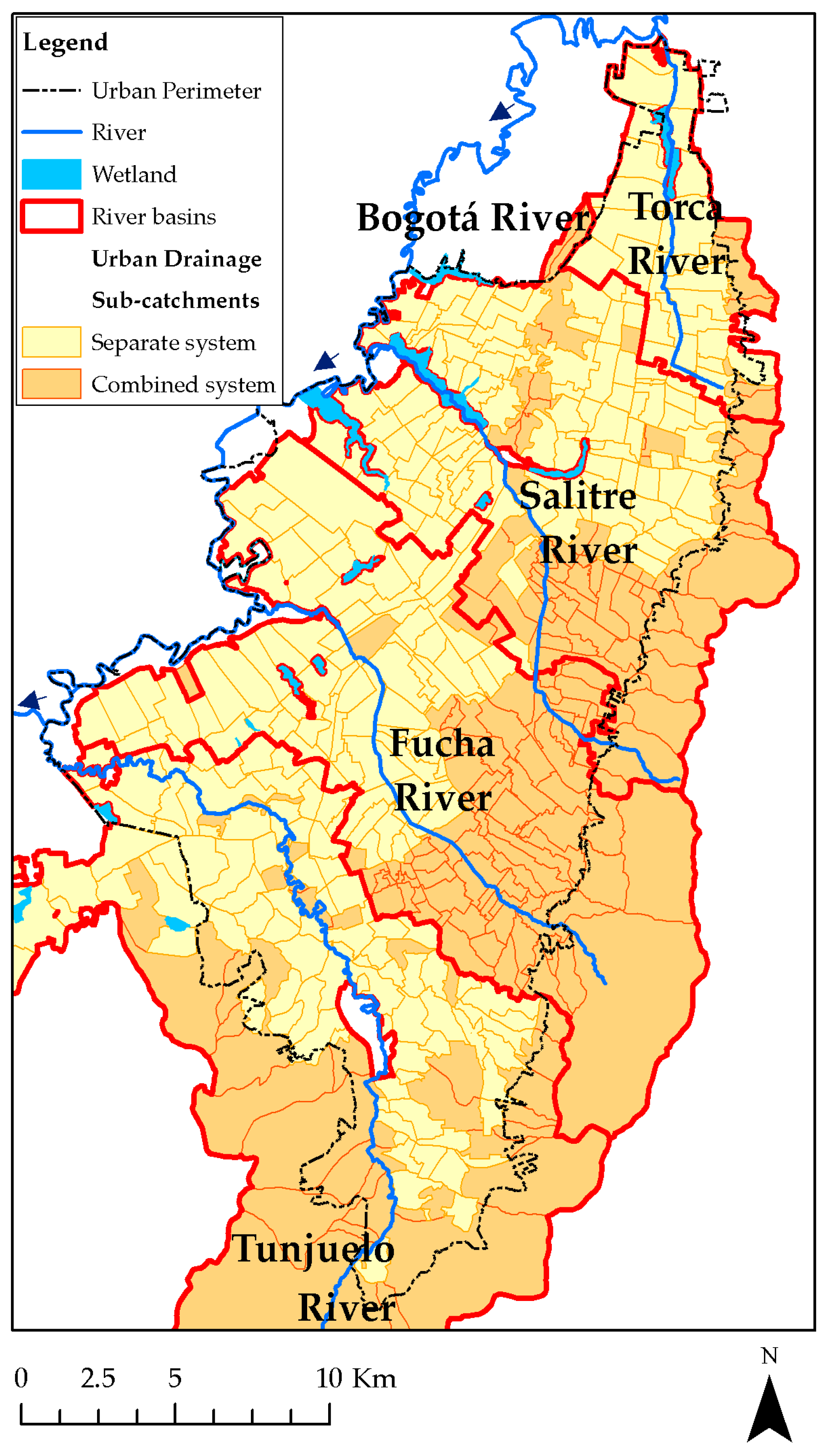
3.1. Citywide Information Sources
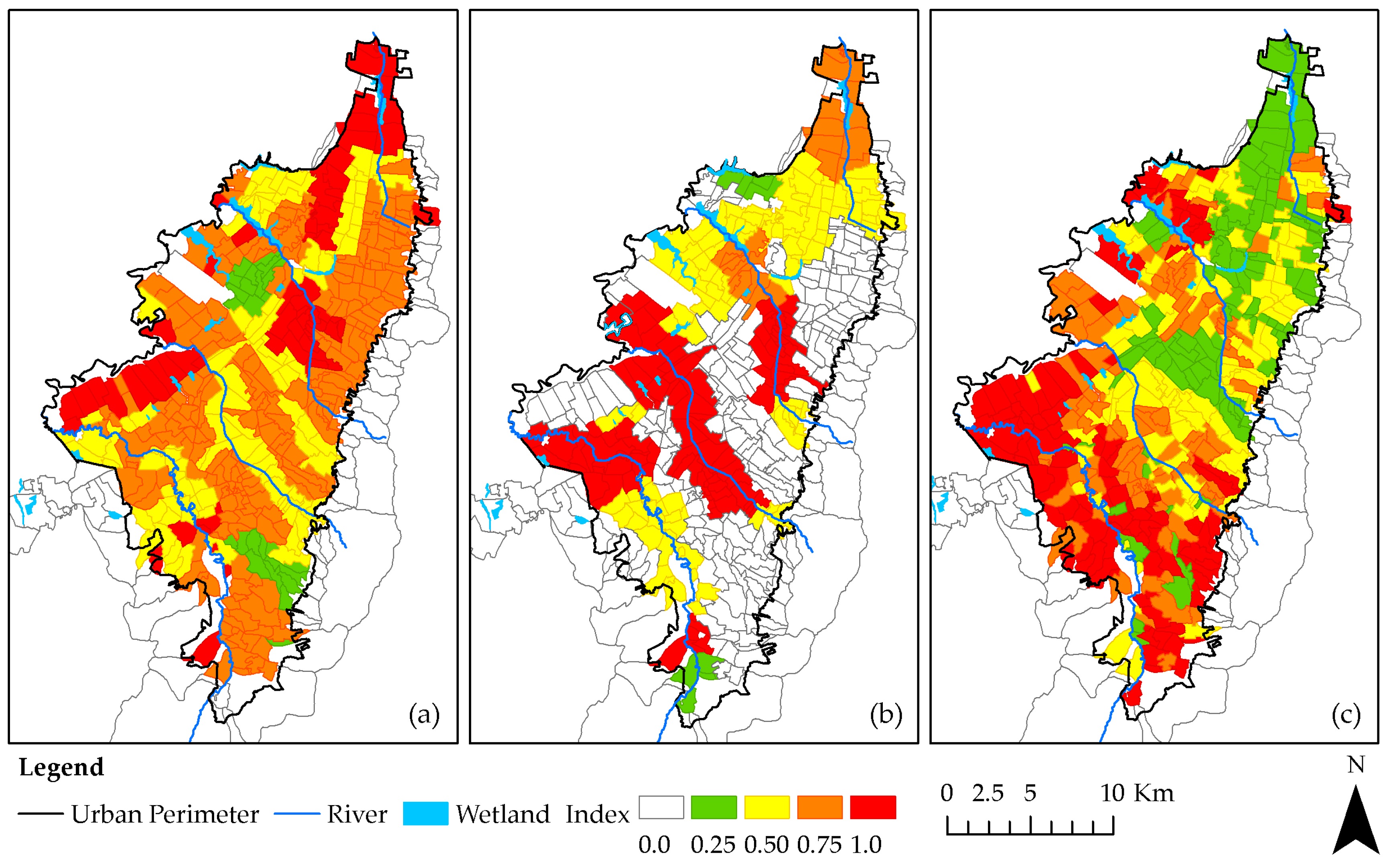
3.1.1. Water Quality Factors
3.1.2. Water Quantity Factors
3.1.3. Environmental and Social Factors
3.1.4. Strategic Urban Drainage Sub-Catchments
3.2. Local Scale Information Sources
4. Results and Discussion
4.1. Citywide Scale
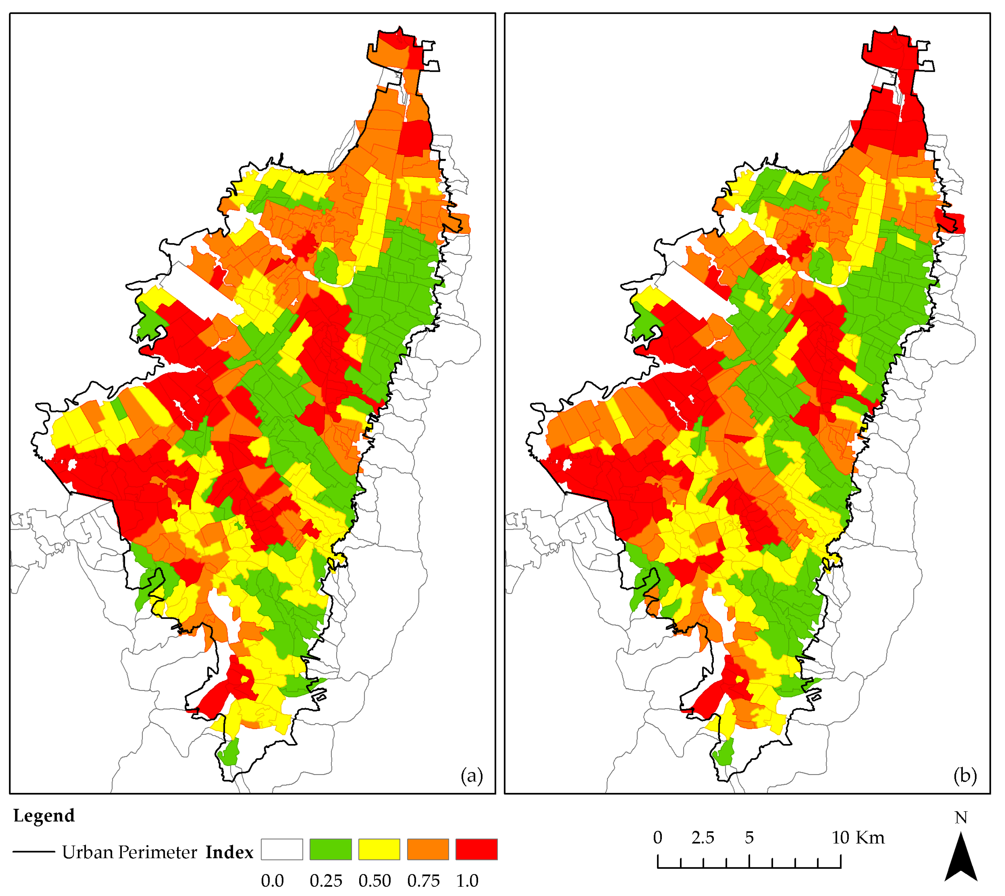
4.1.1. Citywide Objectives
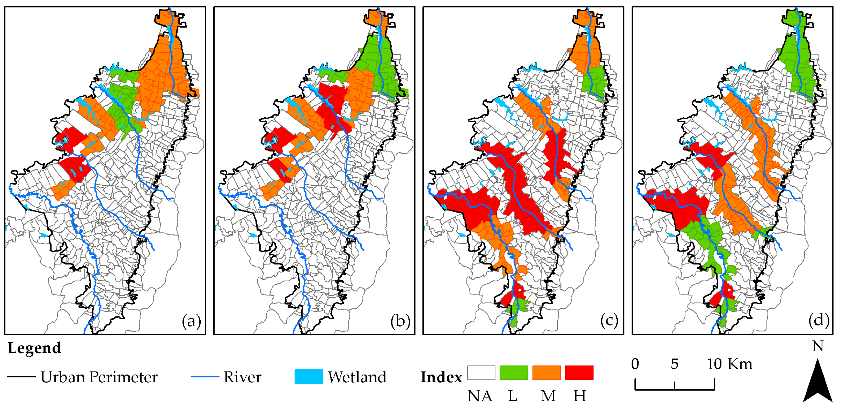
4.1.2. Priority Urban Drainage Sub-Catchments
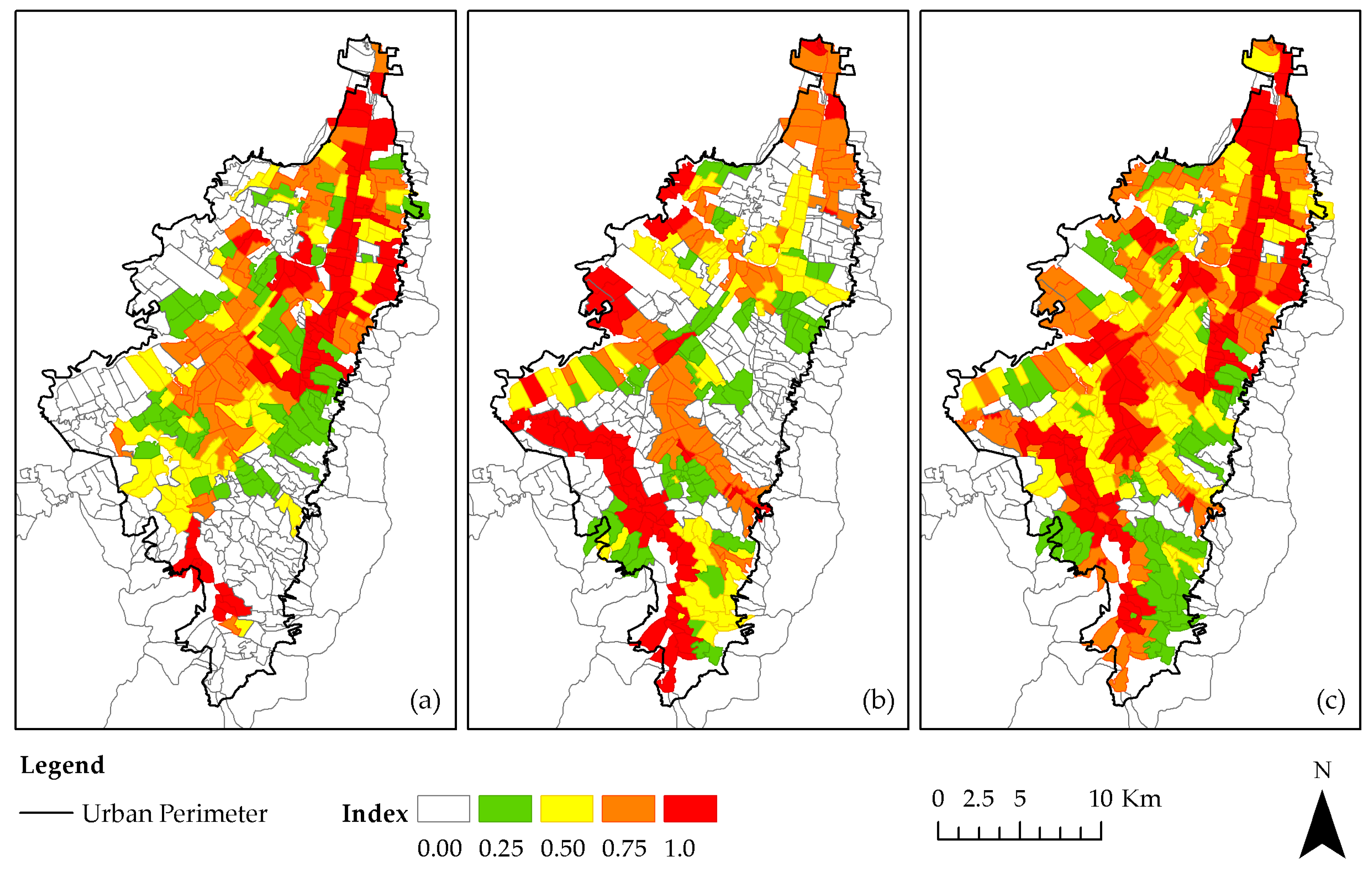
4.1.3. Strategic Urban Drainage Sub-Catchments
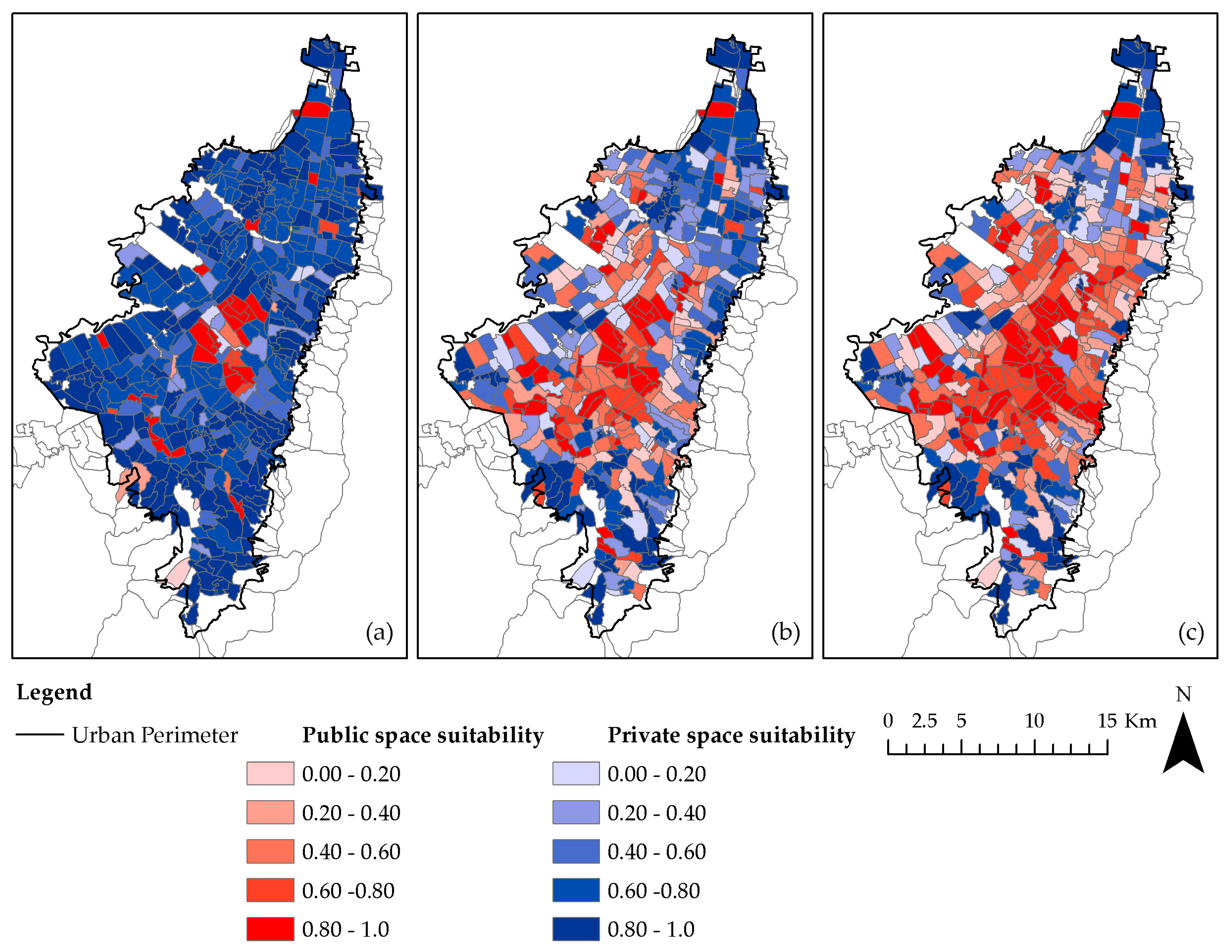
4.2. Local Scale
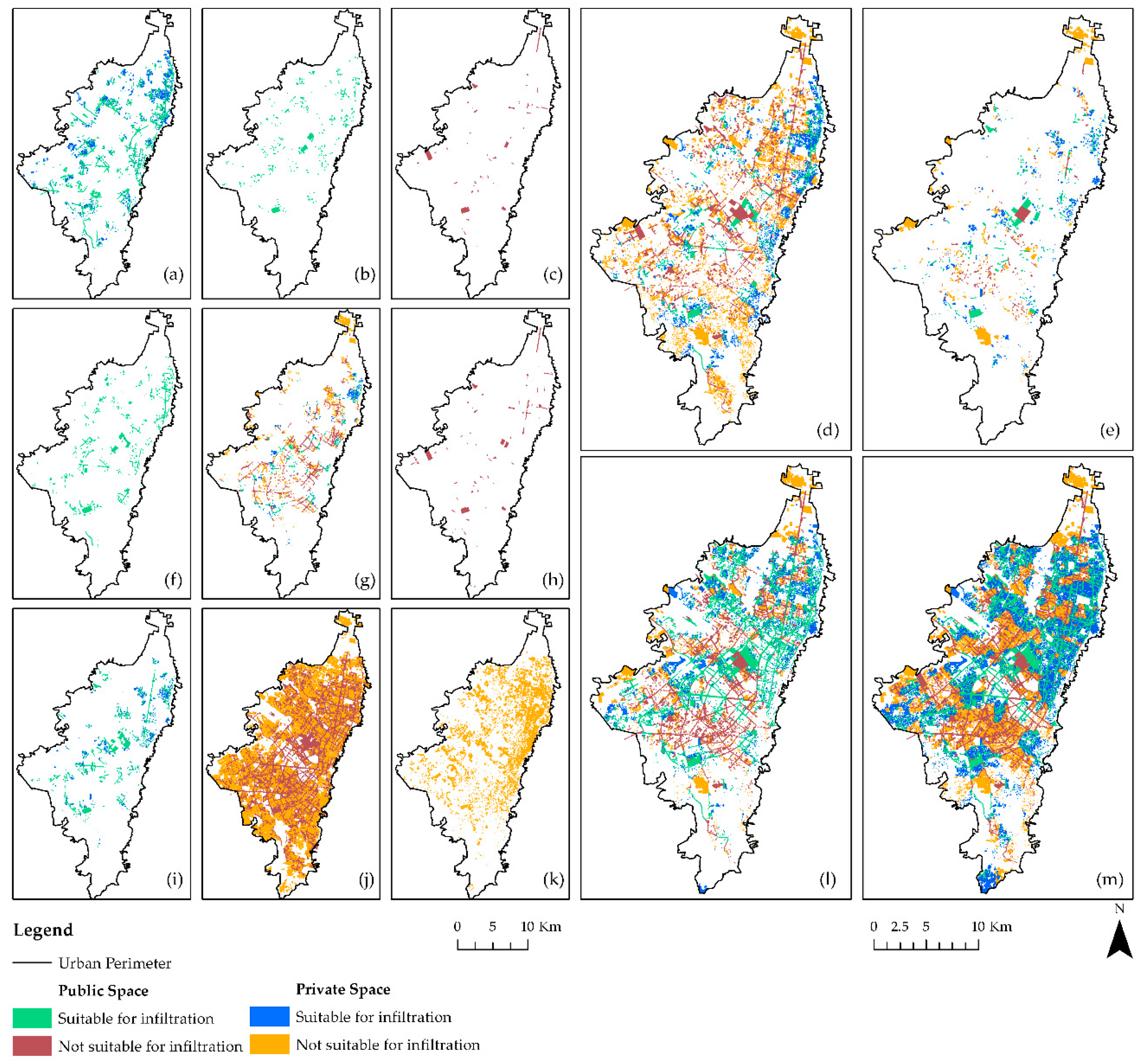
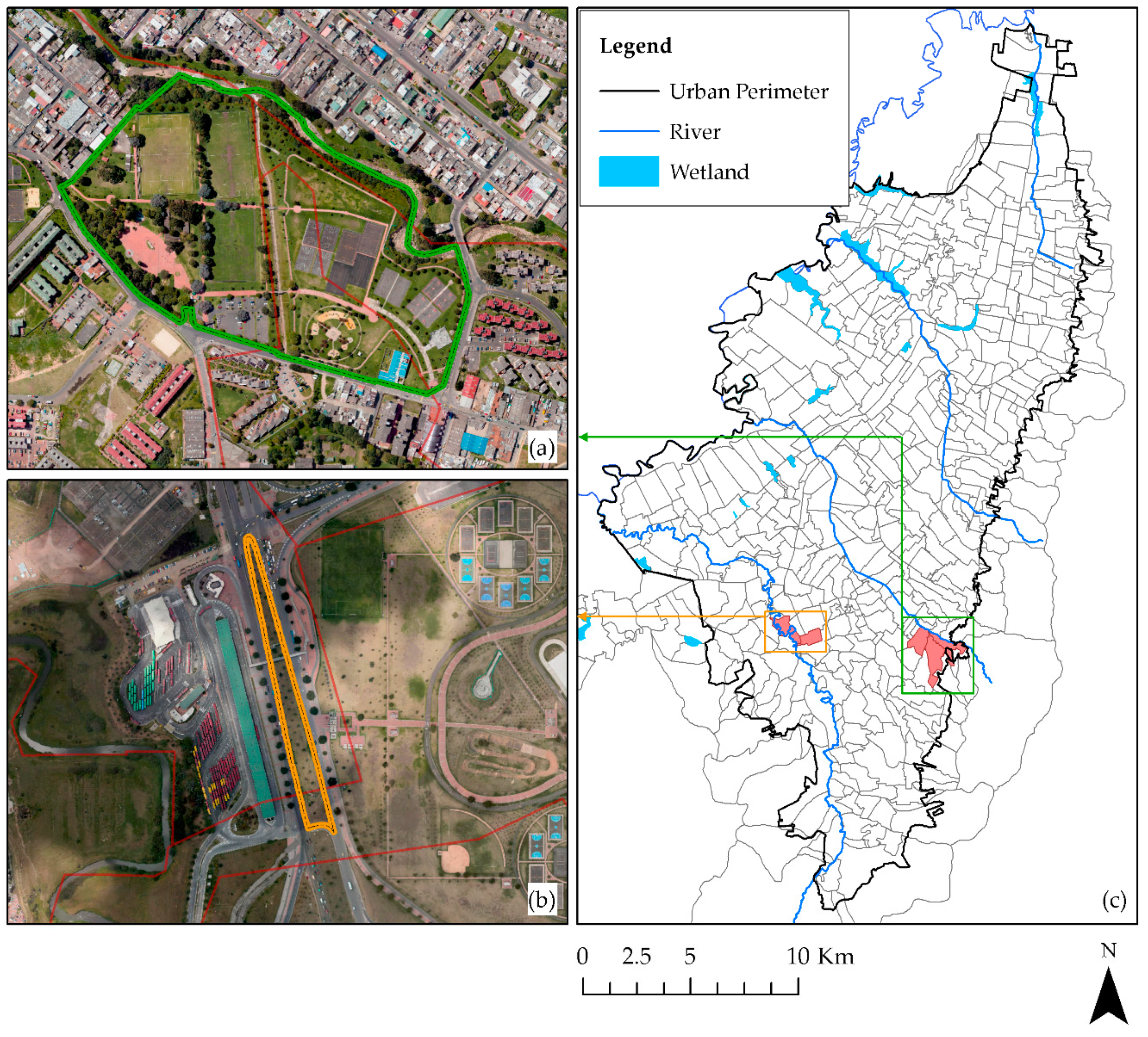
4.3. Microscale
5. Conclusions
Author Contributions
Funding
Acknowledgments
Conflicts of Interest
Appendix A


References
- DANE. Resultados preliminares: Censo Nacional de Población y Vivienda—CNPV 2018. Available online: https://sitios.dane.gov.co/cnpv-presentacion/src/#cuanto00 (accessed on 19 March 2019).
- Aldana-Domínguez, J.; Montes, C.; González, J.A. Understanding the past to envision a sustainable future: A social-ecological history of the Barranquilla Metropolitan Area (Colombia). Sustainability 2018, 10, 2247. [Google Scholar] [CrossRef]
- Shen, L.Y.; Jorge Ochoa, J.; Shah, M.N.; Zhang, X. The application of urban sustainability indicators—A comparison between various practices. Habitat Int. 2011, 35, 17–29. [Google Scholar] [CrossRef]
- Keeley, M.; Koburger, A.; Dolowitz, D.P.; Medearis, D.; Nickel, D.; Shuster, W. Perspectives on the use of green infrastructure for stormwater management in Cleveland and Milwaukee. Environ. Manag. 2013, 51, 1093–1108. [Google Scholar] [CrossRef]
- Poustie, M.S.; Deletic, A.; Brown, R.R.; Wong, T.; de Haan, F.J.; Skinner, R. Sustainable urban water futures in developing countries: The centralised, decentralised or hybrid dilemma. Urban Water J. 2015, 12, 543–558. [Google Scholar] [CrossRef]
- Duffy, A.; Jefferies, C.; Waddell, G.; Shanks, G.; Blackwood, D.; Watkins, A. A cost comparison of traditional drainage and SUDS in Scotland. Water Sci. Technol. 2008, 57, 1451–1459. [Google Scholar] [CrossRef] [PubMed]
- Ossa-Moreno, J.; Smith, K.M.; Mijic, A. Economic analysis of wider benefits to facilitate SuDS uptake in London, UK. Sustain. Cities Soc. 2017, 28, 411–419. [Google Scholar] [CrossRef]
- De Macedo, M.B.; do Lago, C.A.F.; Mendiondo, E.M. Stormwater volume reduction and water quality improvement by bioretention: Potentials and challenges for water security in a subtropical catchment. Sci. Total Environ. 2019, 647, 923–931. [Google Scholar] [CrossRef]
- Winston, R.J.; Dorsey, J.D.; Hunt, W.F. Quantifying volume reduction and peak flow mitigation for three bioretention cells in clay soils in northeast Ohio. Sci. Total Environ. 2016, 553, 83–95. [Google Scholar] [CrossRef]
- Lucke, T.; Nichols, P.W.B. The pollution removal and stormwater reduction performance of street-side bioretention basins after ten years in operation. Sci. Total Environ. 2015, 536, 784–792. [Google Scholar] [CrossRef] [PubMed]
- Braswell, A.S.; Winston, R.J.; Hunt, W.F. Hydrologic and water quality performance of permeable pavement with internal water storage over a clay soil in Durham, North Carolina. J. Environ. Manag. 2018, 224, 277–287. [Google Scholar] [CrossRef]
- Flanagan, K.; Branchu, P.; Boudahmane, L.; Caupos, E.; Demare, D.; Deshayes, S.; Dubois, P.; Meffray, L.; Partibane, C.; Saad, M.; et al. Field performance of two biofiltration systems treating micropollutants from road runoff. Water Res. 2018, 145, 562–578. [Google Scholar] [CrossRef]
- Fletcher, T.D.; Shuster, W.; Hunt, W.F.; Ashley, R.; Butler, D.; Arthur, S.; Trowsdale, S.; Barraud, S.; Semadeni-Davies, A.; Bertrand-Krajewski, J.-L.; et al. SUDS, LID, BMPs, WSUD and more—The evolution and application of terminology surrounding urban drainage. Urban Water J. 2015, 12, 525–542. [Google Scholar] [CrossRef]
- Zevenbergen, C.; Fu, D.; Pathirana, A. (Eds.) Sponge Cities: Emerging Approaches, Challenges and Opportunities. Special Issue; MDPI: Basel, Switzerland, 2018; ISBN 9783038972723. [Google Scholar]
- Martin-Mikle, C.J.; de Beurs, K.M.; Julian, J.P.; Mayer, P.M. Identifying priority sites for low impact development (LID) in a mixed-use watershed. Landsc. Urban Plan. 2015, 140, 29–41. [Google Scholar] [CrossRef]
- Xu, H.; Chen, L.; Zhao, B.; Zhang, Q.; Cai, Y. Green stormwater infrastructure eco-planning and development on the regional scale: A case study of Shanghai Lingang New City, East China. Front. Earth Sci. 2016, 10, 366–377. [Google Scholar] [CrossRef]
- Dagenais, D.; Thomas, I.; Paquette, S. Siting green stormwater infrastructure in a neighbourhood to maximise secondary benefits: Lessons learned from a pilot project. Landsc. Res. 2017, 42, 195–210. [Google Scholar] [CrossRef]
- Meerow, S.; Newell, J.P. Spatial planning for multifunctional green infrastructure: Growing resilience in Detroit. Landsc. Urban Plan. 2017, 159, 62–75. [Google Scholar] [CrossRef]
- Wang, Y.; Montas, H.J.; Brubaker, K.L.; Leisnham, P.T.; Shirmohammadi, A.; Chanse, V.; Rockler, A.K. A Diagnostic Decision Support System for BMP Selection in Small Urban Watershed. Water Resour. Manag. 2017, 31, 1649–1664. [Google Scholar] [CrossRef]
- Heckert, M.; Rosan, C.D. Developing a green infrastructure equity index to promote equity planning. Urban For. Urban Green. 2016, 19, 263–270. [Google Scholar] [CrossRef]
- Garcia-Cuerva, L.; Berglund, E.Z.; Rivers, L. An integrated approach to place Green Infrastructure strategies in marginalized communities and evaluate stormwater mitigation. J. Hydrol. 2018, 559, 648–660. [Google Scholar] [CrossRef]
- Dearden, R.A.; Price, S.J. A proposed decision-making framework for a national infiltration SuDS map. Manag. Environ. Qual. Int. J. 2012, 23, 478–485. [Google Scholar] [CrossRef]
- Jato-Espino, D.; Sillanpää, N.; Charlesworth, S.M.; Andrés-Doménech, I. Coupling GIS with stormwater modelling for the location prioritization and hydrological simulation of permeable pavements in urban catchments. Water 2016, 8. [Google Scholar] [CrossRef]
- Shoemaker, L.; Riverson, J.; Alvi, K.; Zhen, J.X.; Paul, S.; Rafi, T. SUSTAIN—A Framework for Placement of Best Management Practices in Urban Watersheds to Protect Water Quality; National Risk Management Research Laboratory, Office of Research and Development, US Environmental Protection Agency: Cincinnati, OH, USA, 2009.
- Tiwari, K.; Goyal, R.; Sarkar, A. GIS-based Methodology for Identification of Suitable Locations for Rainwater Harvesting Structures. Water Resour. Manag. 2018, 32, 1811–1825. [Google Scholar] [CrossRef]
- Tuomela, C.; Jato-Espino, D.; Sillanpää, N.; Koivusalo, H. Modelling Stormwater Pollutant Reduction with LID Scenarios in SWMM. In New Trends in Urban Drainage Modelling; Mannina, G., Ed.; Springer International Publishing: Cham, Switzerland, 2019; pp. 96–101. ISBN 978-3-319-99866-4. [Google Scholar]
- Cooper, D.; Calvert, J. Ipswich Borough Council Draft Strategic Flood Risk Assessment November 2007; Ipswich Borough Council: Ipswich, UK, 2007.
- Kuller, M.; Bach, P.M.; Ramirez-Lovering, D.; Deletic, A. Framing water sensitive urban design as part of the urban form: A critical review of tools for best planning practice. Environ. Model. Softw. 2017, 96, 265–282. [Google Scholar] [CrossRef]
- Zellner, M.; Massey, D.; Minor, E.; Gonzalez-Meler, M. Exploring the effects of green infrastructure placement on neighborhood-level flooding via spatially explicit simulations. Comput. Environ. Urban Syst. 2016, 59, 116–128. [Google Scholar] [CrossRef]
- Gogate, N.G.; Kalbar, P.P.; Raval, P.M. Assessment of stormwater management options in urban contexts using Multiple Attribute Decision-Making. J. Clean. Prod. 2017, 142, 2046–2059. [Google Scholar] [CrossRef]
- Eaton, T.T. Approach and case-study of green infrastructure screening analysis for urban stormwater control. J. Environ. Manag. 2018, 209, 495–504. [Google Scholar] [CrossRef] [PubMed]
- Morales-Torres, A.; Escuder-Bueno, I.; Andrés-Doménech, I.; Perales-Momparler, S. Decision Support Tool for energy-efficient, sustainable and integrated urban stormwater management. Environ. Model. Softw. 2016, 84, 518–528. [Google Scholar] [CrossRef]
- Wang, M.; Sweetapple, C.; Fu, G.; Farmani, R.; Butler, D. A framework to support decision making in the selection of sustainable drainage system design alternatives. J. Environ. Manag. 2017, 201, 145–152. [Google Scholar] [CrossRef]
- Charlesworth, S.; Warwick, F.; Lashford, C. Decision-making and sustainable drainage: Design and scale. Sustainability 2016, 8, 782. [Google Scholar] [CrossRef]
- Mora-Melià, D.; López-Aburto, C.S.; Ballesteros-Pérez, P.; Muñoz-Velasco, P. Viability of green roofs as a flood mitigation element in the central region of Chile. Sustainability 2018, 10, 1130. [Google Scholar] [CrossRef]
- Gogate, N.G.; Rawal, P.M. Identification of potential stormwater recharge zones in dense urban context: A case study from Pune city. Int. J. Environ. Res. 2015, 9, 1259–1268. [Google Scholar]
- Petit-Boix, A.; Sevigné-Itoiz, E.; Rojas-Gutierrez, L.A.; Barbassa, A.P.; Josa, A.; Rieradevall, J.; Gabarrell, X. Floods and consequential life cycle assessment: Integrating flood damage into the environmental assessment of stormwater Best Management Practices. J. Clean. Prod. 2017, 162, 601–608. [Google Scholar] [CrossRef]
- Zardari, N.H.; Ahmed, K.; Shirazi, S.M.; Yusop, Z.B. Weighting Methods and Their Effects on Multi-Criteria Decision Making Model Outcomes in Water Resources Management; Springer: Cham, Switzerland, 2015; ISBN 9783319125855. [Google Scholar]
- Checkland, P. Soft Systems Methodology: A Thirty Year Retrospective. Syst. Res. Behav. Sci. 2000, 17, 11–58. [Google Scholar] [CrossRef]
- Sánchez, A.; Mejía, A. Learning to support learning together: An experience with the soft systems methodology. Educ. Action Res. 2008, 16, 109–124. [Google Scholar] [CrossRef]
- Chapra, S.C. Surface Water-Quality Modeling; Waveland Press, Inc.: Long Grove, IL, USA, 2008; ISBN 978-1-57766-605-9. [Google Scholar]
- Ekkel, E.D.; de Vries, S. Nearby green space and human health: Evaluating accessibility metrics. Landsc. Urban Plan. 2017, 157, 214–220. [Google Scholar] [CrossRef]
- Deng, H.; Yeh, C.H.; Willis, R.J. Inter-company comparison using modified TOPSIS with objective weights. Comput. Oper. Res. 2000, 27, 963–973. [Google Scholar] [CrossRef]
- Nicoletti, G.; Scarpetta, S.; Boylaud, O. Summary Indicators of Product Market Regulation with an Extension to Employment Protection Legislation; ECO Working Paper No. 226; OECD: Paris, France, 1999. [Google Scholar]
- Jahan, A.; Mustapha, F.; Sapuan, S.M.; Ismail, M.Y.; Bahraminasab, M. A framework for weighting of criteria in ranking stage of material selection process. Int. J. Adv. Manuf. Technol. 2012, 58, 411–420. [Google Scholar] [CrossRef]
- Dylewski, K.L.; Brown, J.T.R.; LeBleu, C.M.; Eve, F. Brantley Low Impact Development Handbook for the State of Alabama; Alabama Department of Environmental Management: Auburn, AL, USA, 2014. [Google Scholar]
- Luoni, S.; Amos, C.A.; Breshears, K.; Huber, J.; Jacobs, C.; Reyenga, S.M.; Komlos, L.; Guzman, D.; Roark, B.; Lewis, S.; et al. Low Impact Development: A Design Manual for Urban Areas; University of Arkansas Community Design Center: Fayetteville, AR, USA, 2010; ISBN 9780979970610. [Google Scholar]
- Wilson, S.; Bray, B.; Neesam, S.; Bunn, S.; Flanagan, E. Sustainable Drainage. Cambridge Design and Adoption Guide; Cambridge City Council: Cambridge, UK, 2009.
- Woods Ballard, W.; Wilson, S.; Udale-Clarke, H.; Illman, S.; Scott, T.; Ashley, R.; Kellager, R. The SuDS Manual; CIRIA: London, UK, 2007; ISBN 978-0-86017-697-8. [Google Scholar]
- Urban Drainage and Flood Control Distric. Urban Storm Drainage. Criteria Manual. Volume 3—Best Management Practices; Water Resources Publications, LLC: Denver, CO, USA, 2010; ISBN 1-887201-66-1. [Google Scholar]
- City of Edmoton. Low Impact Development Best Management Practices Design Guide; City of Edmoton: Edmoton, AB, Canada, 2011. [Google Scholar]
- Lawson, K.; Callow, P.; Shepherd, L.; Goodyear, K.; Presland, V.; Wright, P.; Morris, P.; Hughes, P.; Downs, C.; Dawson, P. Sustainable Drainage Systems (SUDS). Design and Adoption Guide; Essex County Council: Essex, UK, 2012.
- Revitt, M.; Ellis, B.; Scholes, L. Report 5.1. Review of the Use of Stormwater BMPs in Europe; Middlesex University: Middlesex, UK, 2003. [Google Scholar]
- City of Los Angeles. Development Best Management Practices Handbook; City of Los Angeles: Los Angeles, CA, USA, 2011. [Google Scholar]
- Strecker, E.; Sheffield, A.; Cristina, C.; Leisenring, M. Stormwater BMP Guidance Tool. A Stormwater Best Management Practices Guide for Orleans and Jefferson Parishes; Bayou Land RC&D & Louisiana Public Health Institute: New Orleans, LA, USA, 2010.
- Department of Environmental Resources Prince George’s County. Low-Impact Development Design Strategies. An Integrated Design Approach; Department of Environmental Resources Prince George’s County: Largo, MD, USA, 1999.
- Center for Watershed Protection. Maryland Stormwater Design Manual. Volumes I & II; Maryland Department of the Environment: Baltimore, MD, USA, 2000.
- The Low Impact Development Center. Mount Rainier Urban Green Infrastructure Master Plan; The Low Impact Development Center: Beltsville, MD, USA, 2013. [Google Scholar]
- Philadelphia Water Department. Stormwater Management Guidance Manual, Version 3; Philadelphia Water Department: Philadelphia, PA, USA, 2015.
- Riverside County Flood Control and Water Conservation District. Design Handbook for Low Impact Development Best Management Practices; Riverside County Flood Control and Water Conservation District: Riverside, CA, USA, 2011. [Google Scholar]
- City of Santa Rosa. Storm Water. Low Impact Development Technical Design Manual; City of Santa Rosa & The County of Sonoma: Santa Rosa, CA, USA, 2011. [Google Scholar]
- Fernández, B.; Muñoz, J.F.; Varas, E.; Fernández, T.; Destéfano, C.; Pizarro, G.; Rengifo, P.; Benítez, D.; Díaz, M.E.; Courar, P.; et al. Técnicas Alternativas para Soluciones de Aguas Lluvias en Sectores Urbanos. Guía de Diseño; Ministerio de Vivienda y Urbanismo: Santiago, Chile, 1996. [Google Scholar]
- Toronto and Region Conservation Authority; Credit Valley Conservation Authority. Low Impact Development Stormwater Management Planning and Design Guide; Toronto and Region Conservation Authority: Toronto, ON, Canada, 2010. [Google Scholar]
- Melbourne Water. WSUD Engineering Procedures: Stormwater; CSIRO Publishing: Collingwood, VIC, Australia, 2005; ISBN 0-643-09092-4. [Google Scholar]
- Virginia Department of Transportation. BMP Design Manual of Practice; Virginia Department of Transportation: Richmond, VA, USA, 2013. [Google Scholar]
- Department of Water & Swan River Trust. Structural Controls. In Stormwater Management Manual for Western Australia; Department of Water Government of Western Australia: Perth, Australia, 2007; ISBN 978-1-921094-61-3. [Google Scholar]
- Massachusetts Department of Environmental Protection. Structural BMP Specifications for the Massachusetts Stormwater Handbook. In Stormwater Handbook Volume 2; Massachusetts Department of Environmental Protection: Boston, MA, USA, 2008. [Google Scholar]
- Blick, S.A.; Kelly, F.; Skupien, J.J. Stormwater Best Management Practices Manual; New Jersey Department of Environmental Protection Division of Watershed Management: Trenton, NJ, USA, 2004.
- Faha, L.; Faha, M.; Milligan, B. Low Impact Development Approaches Handbook; Clean Water Services: Tualatin, OR, USA, 2009. [Google Scholar]
- Department of Defense USA. Unified Facilities Criteria (UFC): Low Impact Development Manual; Department of Defense USA: Washington, DC, USA, 2010.
- Debo, T.N.; Reese, A.J. Stormwater Management, 2nd ed.; Lewis Publishers: Boca Ratón, FL, USA, 2003; ISBN 1566705843. [Google Scholar]
- Jia, H.; Yao, H.; Tang, Y.; Yu, S.L.; Zhen, J.X.; Lu, Y. Development of a multi-criteria index ranking system for urban runoff best management practices (BMPs) selection. Environ. Monit. Assess. 2013, 185, 7915–7933. [Google Scholar] [CrossRef] [PubMed]
- Moore, S.L.; Stovin, V.R.; Wall, M.; Ashley, R.M. A GIS-based methodology for selecting stormwater disconnection opportunities. Water Sci. Technol. 2012, 66, 275–283. [Google Scholar] [CrossRef]
- Aladenola, O.O.; Adeboye, O.B. Assessing the potential for rainwater harvesting. Water Resour. Manag. 2010, 24, 2129–2137. [Google Scholar] [CrossRef]
- Campisano, A.; Butler, D.; Ward, S.; Burns, M.J.; Friedler, E.; DeBusk, K.; Fisher-Jeffes, L.N.; Ghisi, E.; Rahman, A.; Furumai, H.; et al. Urban rainwater harvesting systems: Research, implementation and future perspectives. Water Res. 2017, 115, 195–209. [Google Scholar] [CrossRef] [PubMed]
- Zhang, X.; Hu, M. Effectiveness of rainwater harvesting in runoff volume reduction in a planned industrial park, China. Water Resour. Manag. 2014, 28, 671–682. [Google Scholar] [CrossRef]
- Coombes, P.J.; Argue, J.R.; Kuczera, G. Figtree Place: A case study in water sensitive urban development (WSUD). Urban Water 2000, 1, 335–343. [Google Scholar] [CrossRef]
- Ghisi, E.; Montibeller, A.; Schmidt, R.W. Potential for potable water savings by using rainwater: An analysis over 62 cities in southern Brazil. Build. Environ. 2006, 41, 204–210. [Google Scholar] [CrossRef]
- Jones, M.P.; Hunt, W.F. Performance of rainwater harvesting systems in the southeastern United States. Resour. Conserv. Recycl. 2010, 54, 623–629. [Google Scholar] [CrossRef]
- Herrmann, T.; Schmida, U. Rainwater utilisation in Germany: Efficiency, dimensioning, hydraulic and environmental aspects. Urban Water 2000, 1, 307–316. [Google Scholar] [CrossRef]
- Rahman, A.; Keane, J.; Imteaz, M.A. Rainwater harvesting in Greater Sydney: Water savings, reliability and economic benefits. Resour. Conserv. Recycl. 2012, 61, 16–21. [Google Scholar] [CrossRef]
- Steffen, J.; Jensen, M.; Pomeroy, C.A.; Burian, S.J. Water supply and stormwater management benefits of residential rainwater harvesting in U.S. cities. J. Am. Water Resour. Assoc. 2013, 49, 810–824. [Google Scholar] [CrossRef]
- United States Environmental Protection Agency. Rainwater Harvesting: Conservation, Credit, Codes, and Cost; United States Environmental Protection Agency: Washington, DC, USA, 2013.
- Ward, S.; Memon, F.A.; Butler, D. Performance of a large building rainwater harvesting system. Water Res. 2012, 46, 5127–5134. [Google Scholar] [CrossRef] [PubMed]
- Boston Water and SewerCommission; Geosyntec Consultants. Stormwater Best Management Practices: Guidance Document; Boston Water and Sewer Commission: Boston, MA, USA, 2013. [Google Scholar]
- Liu, Y.; Engel, B.A.; Flanagan, D.C.; Gitau, M.W.; Mcmillan, S.K.; Chaubey, I. Science of the Total Environment A review on effectiveness of best management practices in improving hydrology and water quality: Needs and opportunities. Sci. Total Environ. 2017, 601–602, 580–593. [Google Scholar] [CrossRef]
- Liu, J.; Sample, D.J.; Bell, C.; Guan, Y. Review and Research Needs of Bioretention Used for the Treatment of Urban Stormwater. Water 2014, 6, 1069–1099. [Google Scholar] [CrossRef]
- Fletcher, T.; Duncan, H.; Poelsma, P.; Lloyd, S. Stormwater Flow and Quality, and The Effectiveness of Non-Proprietary Stormwater Treatment Measures—A Review and Gap Analysis. Technical Report; Cooperative Research Centre for Catchment Hydrology: Melbourne, VIC, Australia, 2004. [Google Scholar]
- Venner, M.; Strecker, E.; Leisenring, M.; Pankani, D.; Taylor, S. NCHRP 25-25/83: Current Practice of Post-Construction Structural Stormwater Control Implementation for Highways; National Cooperative Highway Research Program: Lakewood, CO, USA, 2013. [Google Scholar]
- Rodríguez Susa, M.S.; Porras, L.S.; Martínez León, A.J.; Ramírez Zamudio, N. Calidad del Recurso Hídrico de Bogotá (2012–2013); Universidad de los Andes, Facultad de Ingeniería, Departamento de Ingeniería Civil y Ambiental, Ediciones Uniandes. Alcaldía Mayor, Secretaría Distrital de Ambiente: Bogotá, Colombia, 2014; ISBN 9789587740479. [Google Scholar]
- Empresa de Acueducto Alcantarillado y Aseo de Bogotá (EAB); Secretaria Distrital de Ambiente (SDA). IX Fase del Programa de Seguimiento y Monitoreo de Efluentes Industriales y Afluentes al Recurso Hídrico de Bogotá; Empresa de Acueducto Alcantarillado y Aseo de Bogotá (EAB): Bogotá, Colombia, 2010. [Google Scholar]
- Secretaría Distrital de Planeación (SDP). Sistema de alcantarillado—Mapa No 20; Alcaldía Mayor de Bogotá D.C.: Bogotá, Colombia, 2013. [Google Scholar]
- IEH GRUCON S.A. Recopilación y Análisis de Información Requerida para la Consolidación de la Base de Datos de Conocimiento de los Puntos Críticos del Alcantarillado de Bogotá; EAB: Bogotá, Colombia, 2011. [Google Scholar]
- Secretaría Distrital de Planeación (SDP). Amenaza de inundación por desbordamiento—Mapa Borrador No 04; Alcaldía Mayor de Bogotá D.C.: Bogotá, Colombia, 2013. [Google Scholar]
- Red de Monitoreo de Calidad del Aire de Bogotá (RMCAB). Informe Anual de Calidad del Aire en Bogotá; Secretarí-a Distrital de Ambiente: Bogotá, Colombia, 2017. [Google Scholar]
- Red de Monitoreo de Calidad del Aire de Bogotá (RMCAB). Multi Station Report. Available online: http://201.245.192.252:81/ (accessed on 1 July 2018).
- Ministerio de Ambiente y Desarollo Sostenible. Resolución 2254 de 2017 Ministerio de Ambiente y Desarrollo Sostenible. Por la cual se adopta la norma de calidad del aire ambiente y se dictan otras disposiciones; Ministerio de Ambiente y Desarollo Sostenible: Bogotá, Colombia, 2017.
- Jardín Botánico de Bogotá José Celestino Mutis Visor de Información Geográfica—SIGAU. Available online: http://sigau.jbb.gov.co/SigauJBB/VisorPublico/VisorPublico (accessed on 1 July 2018).
- Infraestructura de Datos Espaciales (IDECA) Mapa de Referencia IDECA. Available online: https://www.ideca.gov.co/es/encuesta mapa-de-referencia-ideca (accessed on 15 June 2018).
- Infraestructura de Datos Espaciales (IDECA) Mapas Bogotá. Available online: http://mapas.bogota.gov.co/# (accessed on 1 July 2018).
- Secretaría Distrital de Ambiente (SDA) Visor Ambiental. Available online: http://www.secretariadeambiente.gov.co/visorgeo/#submenu-capas (accessed on 30 July 2018).
- Instituto de Desarrollo Urbano (IDU); Infraestructura de Datos Espaciales (IDECA) Seguimiento de Proyectos—SIGIDU. Available online: http://idu.maps.arcgis.com/apps/webappviewer/index.html?id=6950db8fa2d440ffbb3946c468eaae4a (accessed on 25 June2018).
- Instituto de Desarrollo Urbano (IDU); Infraestructura de Datos Espaciales (IDECA) Visor de Proyectos. Available online: http://opendata.idu.gov.co/visor_proyectos/ (accessed on 25 June 2018).
- EAB SISGEO. Available online: http://gme.acueducto.com.co/sisgeo/ (accessed on 15 Jun 2015).
- Twarakavi, N.K.C.; Šimůnek, J.; Schaap, M.G. Can texture-based classification optimally classify soils with respect to soil hydraulics? Water Resour. Res. 2010, 46. [Google Scholar] [CrossRef]
- Roy, A.H.; Wenger, S.J.; Fletcher, T.D.; Walsh, C.J.; Ladson, A.R.; Shuster, W.D.; Thurston, H.W.; Brown, R.R. Impediments and Solutions to Sustainable, Watershed-Scale Urban Stormwater Management: Lessons from Australia and the United States. Environ. Manag. 2008, 42, 344–359. [Google Scholar] [CrossRef]
- Brown, R.R. Impediments to integrated urban stormwater management: The need for institutional reform. Environ. Manag. 2005, 36, 455–468. [Google Scholar] [CrossRef]
- Dhakal, K.P.; Chevalier, L.R. Managing urban stormwater for urban sustainability: Barriers and policy solutions for green infrastructure application. J. Environ. Manag. 2017, 203, 171–181. [Google Scholar] [CrossRef]
- Jato-Espino, D.; Charlesworth, S.M.; Bayon, J.R.; Warwick, F. Rainfall-runoff simulations to assess the potential of SUDS for mitigating flooding in highly urbanized catchments. Int. J. Environ. Res. Public Health 2016, 13, 149. [Google Scholar] [CrossRef]
- Kayhanian, M.; Li, H.; Harvey, J.T.; Liang, X. Application of permeable pavements in highways for stormwater runoff management and pollution prevention: California research experiences. Int. J. Transp. Sci. Technol. 2019. [Google Scholar] [CrossRef]
- Liu, Y.; Li, T.; Peng, H. A new structure of permeable pavement for mitigating urban heat island. Sci. Total Environ. 2018, 634, 1119–1125. [Google Scholar] [CrossRef] [PubMed]


| Stage | In Progress | Commissioned | Excluded | Reserved | Suspended | Completed | No Data |
|---|---|---|---|---|---|---|---|
| Activity | |||||||
| Prefeasibility or feasibility studies | 4 | 4 | 0 | 4 | 1 | 4 | 3 |
| Studies and designs | 2 | 3 | 0 | 4 | 1 | 1 | 2 |
| Adaptation | 0 | 0 | 0 | 3 | 0 | 0 | 0 |
| Conservation | 0 | 0 | 0 | 3 | 0 | 0 | 0 |
| Construction | 0 | 0 | 0 | 3 | 0 | 0 | 0 |
| Diagnostic | 0 | 0 | 0 | 0 | 0 | 0 | 0 |
| Road improvement or maintenance (regular or occasional) | 0 | 0 | 0 | 0 | 0 | 0 | 0 |
| Reconstruction | 0 | 0 | 0 | 3 | 0 | 0 | 0 |
| Road rehabilitation | 0 | 0 | 0 | 2 | 0 | 0 | 0 |
| No data | 0 | 0 | 0 | 0 | 0 | 0 | 0 |
| Element | Score |
|---|---|
| Tree-lined roads | 4 |
| Sidewalk | 4 |
| Parking bay | 4 |
| Road | 1 |
| Bike trail | 2 |
| Bus station | 1 |
| Square | 4 |
| Main bus station | 2 |
| Pedestrian bridge | 2 |
| Vehicular bridge | 1 |
| Road divider | 4 |
| Ramp | 2 |
| Green areas | 4 |
| Cable car facilities | 1 |
| SUDS Type | ||||||||||||
|---|---|---|---|---|---|---|---|---|---|---|---|---|
| Parameter | Restriction Type | Grassed Swales | Infiltration Trenches | Permeable Pavements | Wet Ponds | Bioretention Zones | Tree Boxes | Sand Filters | Constructed Wetlands | Soakaways | Infiltration Basin | Extended Dry Detention Basin |
| Slope (%) | Maximum | 10 1 | 5 1 | 5 1 | 15 1 | 10 1 | 10 1 | 5 1 | 15 1 | 15 9 | 3 4 | 15 1 |
| Minimum | 1 11 | 1 2 | 0.5 3 | - | - | - | 1 2 | 1 5 | - | 0 3 | 1 2 | |
| Distance to groundwater level (m) | Minimum | 1.5 1 | 3 2 | 3 8 | 1.3 7 | 1.8 3 | 1 3 | 1.5 1 | 1.3 7 | 1 4 | 1.2 7 | 3 1 |
| Infiltration rate (mm/h) | Minimum | 13 3 | 7 7 | 13 3 | - | 7 10 | 7 10 | 13 7 | - | 13 7 | 13 7 | 7 2 |
| Distance to foundations (m) | Minimum | 4 9 | 6 12 | 6 12 | 6 12 | 6 12 | 2 13 | 1.5 6 | 6 12 | 6 12 | 6 12 | 6 2 |
| Area (m2) | Minimum | - | - | - | 150 14 | - | - | - | 1000 7,15 | - | 45 | 45 |
| Length to width ratio | Minimum | - | - | - | 2:1 14 | - | - | - | 3:1 4 | - | 2:1 6 | 2:1 6 |
| Width (m) | Minimum | - | - | - | 8 14 | - | - | - | 18 | - | 5 | 5 |
| Length (m) | Minimum | - | - | - | 20 14 | - | - | - | 56 | - | 9 | 9 |
| Public space | Type | P R | P R | S W Pa | P R | P S R W | P S R W | P R | P R | P S R W | P R | P R |
| Private space | Use 16 | Re C D | Re C D | Re C D | C D | Re C D | Re C D | Re C D | Re C D | |||
| SUDS Type | Quality Improvement | Runoff Control | Amenity | Maintenance | Cost | ||||||||||
|---|---|---|---|---|---|---|---|---|---|---|---|---|---|---|---|
| Nutrients | Metals | Bacteria | Sediment | Oil and Grease | Trash and Debris | Filtration and Sorption | Volume Control | Maximum Discharge Control | Perception Improvement | Interference with Activities on Site | Safety risks (users) | Activities and Risk of Clogging | Capital Cost | Maintenance Cost | |
| Grassed swale | M 1,2,3 | M 1 | L 1 | M 1,2,3 | M 1 | M 1 | L 1 | L 1 | L 1 | M | H | H | L | L 8 | L 8 |
| Rain barrel and cistern (RWH) | N 1 | N 1 | N 1 | N 1 | N 1 | N 1 | N 1 | M 1 | M 1 | N | L | L | L | M 8 | M 8 |
| Bioretention zone b | M 1,4,5 | H 1,3,4,5 | M 4,5 | M 4,5 | H 1 | H 1 | H 1 | M 1 | L 1 | H | H | M | M | M 8 | M 8 |
| Tree box b | M 1 | M 1 | M a | M 1 | H 1 | H 1 | M 1 | L 1 | L 1 | M | L | L | M | M 8 | M 8 |
| Extended dry detention basin b | L 2,3,6 | M 2 | M 2,3,6 | M 2,3 | M 2 | H | L 7 | L | M | H | M | M | M | M 8 | M 8 |
| Infiltration trench | M 2,3 | H 1 | H 1 | H 1 | M 1 | H 1 | H 1 | H 1 | H 1 | N | M | M | H | M 8 | M 8 |
| Permeable pavement b | L 3 | M 1 | M 1 | H 1 | H 1 | M | M 1 | H 1 | M 1 | N | L | L | M | H 8 | H 8 |
| Wet pond | M 2,3 | M 2,3 | M 2,3 | M 2,3 | M 2 | H 6 | L 7 | L | H | H | H | H | M | H 8 | M 8 |
| Sand filter b | M 1,3 | M 3,6 | M 1 | H 1,3 | M 1 | H 6 | H 1 | L 1 | L 1 | L | M | M | H | M 8 | H 8 |
| Constructed wetland | M 1,2,3,6 | M 2,3,6 | M 3 | H 1 | H 1 | H 6 | M 1 | L 1 | H 1 | H | H | H | H | H 8 | M 8 |
| Soakaway | L 1 | L 1 | L 1 | H 1 | L 1 | L 1 | M 1 | H 1 | M 1 | N | L | L | M | M | M |
| Infiltration basin | M 1,2 | H 1 | H 1 | H 1 | M 1 | H 1 | M 1 | H 1 | M 1 | H | M | M | H | M | H |
| Green roof | L 1 | L 1 | L 1 | L 1 | L 1 | L 1 | L 1 | H 1 | M 1 | M | L | L | M | H 8 | L 8 |
| Final Process | Infiltration | Detention | Conveyance | Rainwater Harvesting (RWH) | Irrigation |
|---|---|---|---|---|---|
| Initial Process | |||||
| Infiltration | X | X | X | ||
| Detention | X | X | X | X | |
| Conveyance | X | X | X | X | |
| Rainwater harvesting (RWH) | |||||
| Irrigation |
| FINAL | Grassed Swale | Rain Barrel and Cistern (RWH) | Bioretention Zone | Tree Box | Extended Dry Detention Basin | Infiltration Trench | Permeable Pavement | Wet Pond | Sand Filter | Constructed Wetland | Soakaway | Infiltration Basin |
|---|---|---|---|---|---|---|---|---|---|---|---|---|
| INITIAL | ||||||||||||
| Grassed swale | C.D C.R C.Ir | C.D C.I C.Ir | C.D C.I C.Ir | C.D C.I | C.I | C.I | C.D | C.D C.I | C.D C.Ir | C.D C.I | C.D C.I | |
| Rain barrel and cistern (RWH) | D.C | D.C D.I | ||||||||||
| Bioretention zone | I.C D.C | C.D D.R I.R D.Ir I.Ir | C.D | C.D | I.C D.C D.I | C.D D.I | C.D | C.D | C.D | C.D | ||
| Tree box | I.C D.C | D.R I.R D.Ir I.Ir | D.Ir | I.C D.C D.I | D.I | |||||||
| Infiltration trench | I.C | D.R I.R C.R D.Ir I.Ir CIr | C.I C.Ir | C.I C.Ir | C.Ir | C.I | C.I | |||||
| Permeable pavement | D.R I.R D.Ir I.Ir | |||||||||||
| Sand filter | I.C | D.R D.Ir I.R I.Ir | I.C | |||||||||
| Soakaway | D.R I.R D.Ir I.Ir | D.Ir | D.Ir | |||||||||
| Green roof | D.C | D.R D.Ir | D.Ir | D.Ir | D.C D.I | D.I | D.I | D.I |
| Process | Infiltration | Detention | Conveyance | Rainwater Harvesting | Irrigation |
|---|---|---|---|---|---|
| SUDS Type | |||||
| Grassed swale | 2 | 1 | 5 | 0 | 0 |
| Rain barrel and cistern (RWH) | 0 | 4 | 0 | 5 | 5 |
| Bioretention zone | 3 | 4 | 0 | 0 | 4 |
| Tree box | 3 | 4 | 0 | 0 | 4 |
| Extended dry detention basin | 3 | 5 | 0 | 1 | 1 |
| Infiltration trench | 5 | 3 | 3 | 0 | 0 |
| Permeable pavement | 5 | 3 | 0 | 0 | 0 |
| Wet pond | 0 | 5 | 0 | 0 | 0 |
| Sand filter | 3 | 4 | 0 | 0 | 0 |
| Constructed wetland | 0 | 5 | 0 | 0 | 3 |
| Soakaway | 5 | 3 | 0 | 0 | 0 |
| Infiltration basin | 5 | 5 | 0 | 0 | 0 |
| Green roof | 0 | 3 | 0 | 0 | 4 |
| Processes | C–Ir | D–Ir | C–D | C–I | ||
|---|---|---|---|---|---|---|
| Possible trains | 2 | 1 | 7 | 5 | ||
| SUDS types | Most frequent train | |||||
| Tree box | 1 | |||||
| Bioretention zone | 2 | 2 | 2 | 1 | ||
| Grassed swale | 1 | 1 | 1 | 2 | ||
| Extended dry detention basin | 2 | |||||
| Frequency | 93% | 100% | 100% | 79% | ||
| Higher score over 5 (most frequent train) | 4.27 | 3.96 | 4.50 | 4.02 | ||
| Evaluated weights (%) | Most frequent train weights (%) | |||||
| Quality improvement |  |  |  |  |  | |
| Runoff Control |  |  |  |  |  | |
| Amenity |  |  |  |  |  | |
| Maintenance |  |  |  |  |  | |
| Costs |  |  |  |  |  | |
| Processes | C–R | D–R | C–D | I–R | C–I | I–D | |||
|---|---|---|---|---|---|---|---|---|---|
| Possible trains | 2 | 3 | 11 | 3 | 10 | 3 | |||
| SUDS types | Most frequent train | ||||||||
| Tree box | |||||||||
| Bioretention zone | 1 | 1 | 2 | 1 | |||||
| Underground cistern | 2 | 2 | 2 | ||||||
| Grassed swale | 1 | 2 | 1 | 1 | 1 | 2 | |||
| Infiltration trench | 2 | 1 | 2 | ||||||
| Frequency | 100% | 92% | 79% | 100% | 100% | 79% | |||
| Higher score over 5 (most frequent train) | 4.73 | 4.13 | 4.21 | 4.39 | 4.42 | 4.24 | |||
| Evaluated weights (%) | Most frequent train weights (%) | ||||||||
| Quality improvement |  |  |  |  |  |  |  | ||
| Runoff Control |  |  |  |  |  |  |  | ||
| Amenity |  |  |  |  |  |  |  | ||
| Maintenance |  |  |  |  |  |  |  | ||
| Costs |  |  |  |  |  |  |  | ||
© 2019 by the authors. Licensee MDPI, Basel, Switzerland. This article is an open access article distributed under the terms and conditions of the Creative Commons Attribution (CC BY) license (http://creativecommons.org/licenses/by/4.0/).
Share and Cite
Jiménez Ariza, S.L.; Martínez, J.A.; Muñoz, A.F.; Quijano, J.P.; Rodríguez, J.P.; Camacho, L.A.; Díaz-Granados, M. A Multicriteria Planning Framework to Locate and Select Sustainable Urban Drainage Systems (SUDS) in Consolidated Urban Areas. Sustainability 2019, 11, 2312. https://doi.org/10.3390/su11082312
Jiménez Ariza SL, Martínez JA, Muñoz AF, Quijano JP, Rodríguez JP, Camacho LA, Díaz-Granados M. A Multicriteria Planning Framework to Locate and Select Sustainable Urban Drainage Systems (SUDS) in Consolidated Urban Areas. Sustainability. 2019; 11(8):2312. https://doi.org/10.3390/su11082312
Chicago/Turabian StyleJiménez Ariza, Sara Lucía, José Alejandro Martínez, Andrés Felipe Muñoz, Juan Pablo Quijano, Juan Pablo Rodríguez, Luis Alejandro Camacho, and Mario Díaz-Granados. 2019. "A Multicriteria Planning Framework to Locate and Select Sustainable Urban Drainage Systems (SUDS) in Consolidated Urban Areas" Sustainability 11, no. 8: 2312. https://doi.org/10.3390/su11082312
APA StyleJiménez Ariza, S. L., Martínez, J. A., Muñoz, A. F., Quijano, J. P., Rodríguez, J. P., Camacho, L. A., & Díaz-Granados, M. (2019). A Multicriteria Planning Framework to Locate and Select Sustainable Urban Drainage Systems (SUDS) in Consolidated Urban Areas. Sustainability, 11(8), 2312. https://doi.org/10.3390/su11082312