Article

Social Perception of Geo-Hydrological Risk in the Context of Urban Disaster Risk Reduction: A Comparison between Experts and Population in an Area of Southern Italy

by
Loredana Antronico
1,*,
Roberto Coscarelli
1,
Francesco De Pascale
1 and
Francesca Condino
2
1
Italian National Research Council, Research Institute for Geo-Hydrological Protection, Via Cavour, 4–6, 87036 Rende, Italy
2
Department of Economics, Statistics and Finance, University of Calabria, 87036 Rende, Italy
*
Author to whom correspondence should be addressed.
Sustainability 2019, 11(7), 2061; https://doi.org/10.3390/su11072061
Submission received: 28 February 2019 / Revised: 29 March 2019 / Accepted: 2 April 2019 / Published: 7 April 2019
(This article belongs to the Special Issue Urban Disaster Risk Reduction)

Abstract

:
The perception of risk is influenced by how the signals about impacts of events are collected, selected, and interpreted. Empirical data suggest that significant differences in the perception of risk occur within the non-expert population itself, as well as between experts and non-expert population. The paper seeks to examine the risk perception of citizens living in an area subject to high hydro-geological risk of Calabria (Southern Italy), and understanding if local policy makers are aware of how local residents perceive risk. Quantitative and qualitative methods were employed to analyze the perception of experts, stakeholders and citizens on the following research topics: (i) perception of geohydrological risk, involvement in past events and behavior exhibited; (ii) information, communication, preparedness, and feeling of safety and trust. The results of the survey showed the communication gap between experts and people, evidencing the need for local authorities and experts to disseminate the culture of awareness on the risk and to increase the safety level of the citizens by means of participated actions aimed at reducing urban disaster risk.

1. Introduction

The term “natural hazard” is a widely used term for scientists, authorities and practitioners, indicating the natural processes occurring in the environment constituting a damaging event for people. The entire world’s population is exposed to natural hazards in different ways and degrees. The scientific community agrees that the economic and human impact of natural hazards and related disasters has risen in recent decades [1,2,3,4].
Despite natural hazards in the Mediterranean causing hundreds of casualties and considerable economic loss and, despite the commitment of authorities at any level to safeguard people, properties and cultural heritage, the culture of risk education and prevention is not widespread in this territory also because of the lack of initiatives of information and awareness [5]. Risk education and preparation is fundamental when living in a risk area, as it helps increase people’s security by improving their capacity to overcome a disrupted scenario [6].
In fact, education, governance and health are considered the three main determinants of social vulnerability at the national level [7]. A survey conducted by Dowling and Santi [8], by means of several socioeconomic indicators showed that landslide mortality is greater in developing countries that are characterized by significant poverty, corrupt governments and weaker healthcare systems; all these factors, in fact, make such territorial ecosystems more fragile and vulnerable. Toya and Skidmore [9] underlined that both higher income and educational level are important indicators of development that may reduce vulnerability to disasters resulting from natural hazards. The educational level as a predictor of vulnerability to floods and landslides was tested in Nepal [10] by means of two sources of data: the yearly data on losses caused by floods and landslides, at village level, and micro-data at individual level. The comparison of these two data typologies allowed researchers to assess that the educational level of a community is associated with its vulnerability to floods and landslides. It is well known that societies with higher educational levels are more adaptive in response to disasters [11]. Education enhances knowledge on disaster risks and influences risk perception [12,13].
If on one side, therefore, it is important for a community to be aware of its exposure to natural hazards, it is even more important for policy makers/local government authorities be informed about their communities’ perception so as to set appropriate standards and policies. Understand how the public perceive risk is therefore crucial in determining how to disseminate appropriate information with the aim to increase public trust in authorities and, through this, to enhance the community’s capacity to respond to extreme events and to increase people’s resilience [14,15]. Some authors (e.g., [15,16]) highlighted the significant gap between the general public’s knowledge and risk perception and experts’ risk perception related to flood events. In a case study on the perception of flood risk in Pakistan, the results revealed it greatly varies between government officials and community members, thus recommending policies and programs for creating awareness and preparedness for flood risk perception among the people [17]. Another survey carried out in Zimbabwe [18] assumes that the core of the issues related to disaster risk is not primarily located in governmental agencies, but in the communities where the risk is generated and experienced. In Italy an important role in strengthening the risk communication between institutions and citizens is carried out by the National Civil Protection Organization, which is a structure of the Presidency of the Council of Ministers, was set up for predicting and preventing the various risk assumptions, helping disaster victims and for doing any other necessary and non-transferable activities to overcome the emergency [19,20]. However, despite the important function carried out by the National Civil Protection Organization, several case studies in Italy, from north to south, show that communication and collaboration between institutions and the citizens is at high levels only immediately after the disaster has occurred (e.g., [20,21,22,23,24,25]). But the focus on the places and the people affected tends to gradually fade and then completely disappear, until the next disaster occurs [26]. The case study discussed in this article also demonstrates and highlights this aspect.
In this context, the paper seeks to examine the perception of geo-hydrological risk of citizens living in Calabria (Southern Italy) in an area subject to high hydro-geological risk and at understanding if local policy-makers (experts involved in the management of the study area) are aware of how local residents perceive risk. Quantitative and qualitative methods were employed to analyze the perception of experts and citizens on the following research topics: (i) perception of geohydrological risk, involvement in past events and behavior exhibited; (ii) information, communication, preparedness, and feeling of safety and trust.
A qualitative analysis of the first results [27] and a short summary in which some results compared through statistical analyzes were reported [28], have already been published. But this contribution enriches the research by comparing specific results through statistical analysis and highlighting the differences and similarities regarding the risk perception of local policy-makers and citizens. Moreover, the present paper offers a detailed framework of the research carried out and a deepening of the analysis of the results using predominantly quantitative methods, also in light of the extensive literature on the Urban Disaster Risk Reduction and the social construction of disasters.

2. Urban Disaster Risk Reduction and Social Construction: The Reference Framework

The knowledge of risks and disasters associated with them is still severely hampered by the predominance of physical factors that influence the risk without considering social aspects that are also fundamental. Despite the presence of various world programs of which the most recent is the Sendai Framework for Disaster Risk Reduction [29], the inclusion of key nodes of disaster risk reduction (DRR) in national policies is still slow, gradual and far from being completed [30]. Indeed, little progress has been reported on Priority 4 of the Hyogo Framework for Action (Reduce the underlying risk factors) [31], which is crucial because it envisages identifying the factors that triggered the disasters [32]. Attempts to advance knowledge based on the development of a construction of disasters’ risk have been severely hindered by the expansion of already existing policies, dominated exclusively by responses to disasters, thus ignoring prevention and fueling increasing future losses and therefore of increasing demand for response [32]. At the same time, with few exceptions, experts, stakeholders and policy makers, which should be at the forefront of promoting reduction, control and risk prevention, are not yet convinced about the need to personally identify the solutions to this type of problems. In contrast, Lassa [33] asserted that nations that promote good governance and stronger institutions have a tendency to demonstrate better policies on disaster risk reduction, which in turns leads to an increase in disaster risk resilience [33,34]. In this context, an integrated disaster risk research program, supported jointly by UNISDR (United Nations Office for Disaster Risk Reduction), located in its headquarters in Geneva (Switzerland) and ISSC (International Social Science Council, merged in July 2018 with the International Council for Science, creating a single council that represents the global voice for all the sciences), has developed a working group called Forensic Investigation of Disasters (FORIN) focusing on research related to the root and underlying causes of disasters [35,36,37]. It is hoped that the FORIN approach to risk and disaster research will help change the mind-set of public actors, the private sector and governments, and create a more determined movement towards risk reduction and control. In fact, disaster risk reduction, control and prevention must be permanently and organically integrated into decision-making processes for planning sustainable community development and economic and social growth in all countries. The main causes contributing to the risk of disasters should be clearly identified along with the ways in which they could be reduced or avoided [32].
These research programs should, in turn, nurture the establishment of educational programs in all countries and at all levels, illustrating and proving the social construction of risk. García Acosta [37] defined the social construction of risk as a process developed by groups or communities, which would place them in the context of different phases or different levels of vulnerability. Moreover, the historical and anthropological perspective of the study of disasters has shown, thanks to documentary and field researches, that the society is primarily responsible for the increase in vulnerability and for the amplification and intensification of the risk of disasters [38]. But it is also through society that the means must be found to minimize the impacts and effects of disasters [39] and achieve better results in the field of Disaster Risk Reduction. Some scholars [39,40,41], starting from the study by Matteucci et al. [42], proposed a conceptual and semiotic map in the form of a triangle, which places greater emphasis on the incidence and direct responsibility of human (social, political and economic) factors in catastrophic events, thus establishing a link of consequential and mutual co-existence between “society” and the “disease of the planet” (Figure 1). That is, the consequences in terms of human lives and/or material damage to society are a sign of the “disease of the planet”. But also, the “disease of the planet” is a sign of the negative impact of the society. In fact, “disease of the planet” is represented by both natural phenomena that are potentially damaging for society and the similarly damaging effects of society’s impact on the Earth planet [42]. In light of these observations, some authors have found more appropriate to define disasters as “socionatural” instead of “natural” processes [25,43,44,45,46].
In the proposed triangle, geoethics has been defined as the investigation of and reflection on the operational behavior of humans towards the geosphere [47,48], represents the “interpreter” of ethical responsibilities towards the society and the planet (Figure 1).
According to the Focus of Urban Risk of International Federation of Red Cross and Red Crescent Societies [49], city and municipal governments, in implementing their disaster risk reduction policies in areas where urban development and expansion are taking place, should give greater consideration to the most vulnerable social groups (poor and marginalized groups) to prevent structural and socioeconomic obstacles [49].
In Italy, from the second post-war period onwards, the intense urbanization that took place without considering the areas of the country in which dangerous geohydrological and hydraulic events could occur, led to a considerable increase in the exposed and vulnerable elements and, therefore, of risk [50], thus increasing the need to put disaster risk reduction strategies into practice, especially starting from the knowledge and analysis of values, perceptions and behavior of the population.
In this framework, it appears pertinent to conduct research on the public perception of geo-hydrological risk, characterizing it by a comparison between experts, local policy-makers and the population; in fact, analyzing the perception of such a community risk means obtaining inputs to improve risk communication and to design effective measures to prepare for an extreme event. The knowledge acquired from individual and group differences regarding risk perception can be used by local authorities to regulate interventions aimed at educating people on the risk and encouraging effective risk reduction behavior [51,52].

3. Materials and Methods
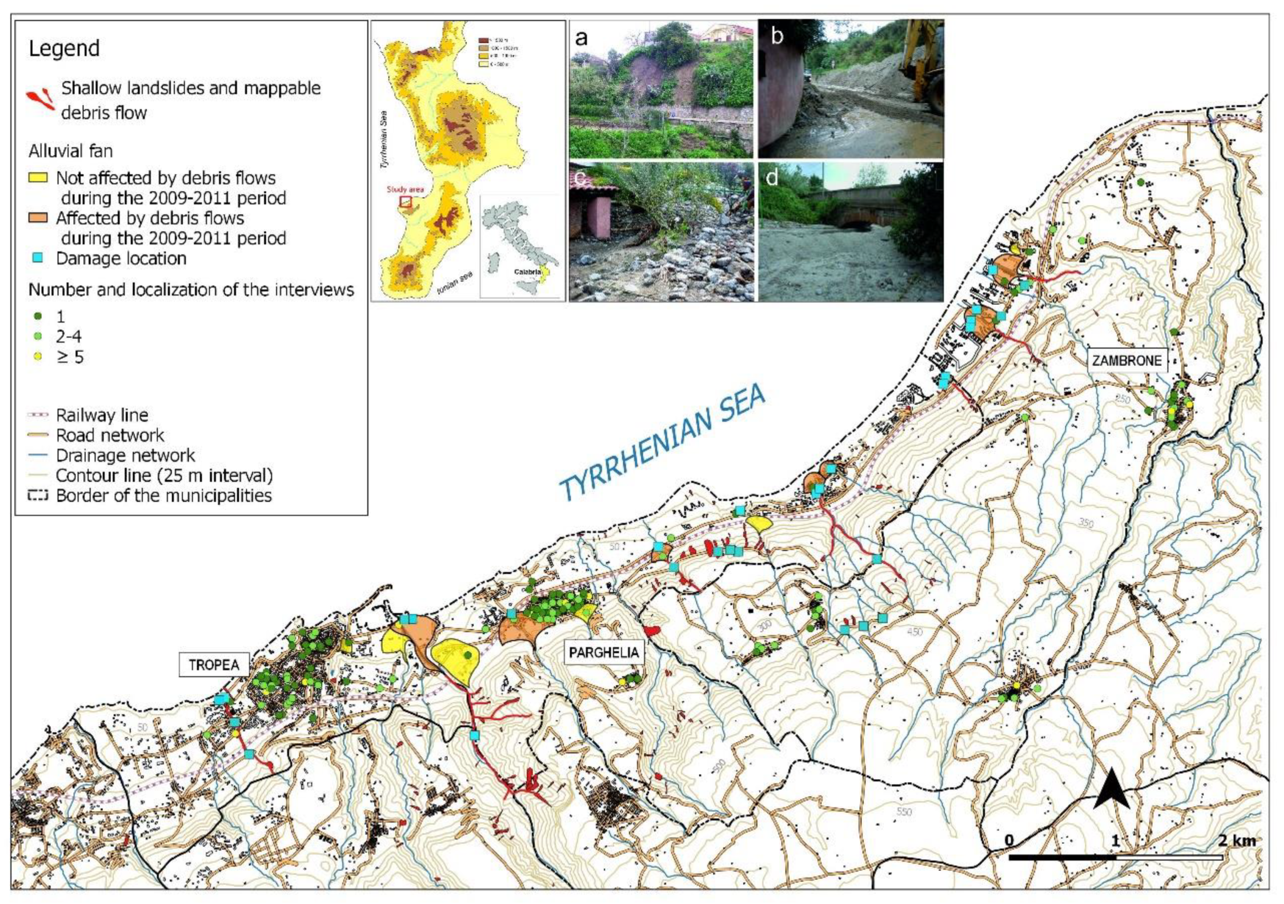
3.1. Study Area

The study area is located along the Tyrrhenian seacoast of southern Calabria where shallow landslides and debris flows represent the main natural hazards. In particular, the locations of the survey coincide with the area of the municipalities of Zambrone, Parghelia and Tropea (in the Province of Vibo Valentia), whose territories extend from the sea level to a maximum of 600 m a.s.l. (Figure 2).
Small drainage basins with very high slope gradient and outcropping landslide-prone weathered rocks characterize the geomorphological and geological contexts of the study area. These features, along with high climate variability (a typical Mediterranean climate with very dry periods and frequent rainfall events) make the area susceptible to floods, shallow landslides and debris flows [27,53,54]. Debris flows are a type of fast-moving landslides characterised by a mixture of sand, gravel, cobbles, tree limbs, etc., and a variable quantity of water rapidly moving downslope and commonly following pre-existing drainage ways [55]. The moving mass, that often travels considerable distances from the source area, is deposited where the channel gradient decreases; successive debris flows deposits build an alluvial fan. The dangerousness of these natural phenomena, of which rain is the main triggering cause, is caused by their rapid kinematic evolution that often does not allow to timely warn the communities involved.
A set of recent alluvial fans extends on the narrow coastal plain, at the mouths of the small drainage basins that fall within the study area; the origin of these alluvial fans is mainly due to debris flows [53].
The analysis of recent documents on debris flow events occurred in the study area indicated the absence of important depositional events such as debris flow/alluvial deposits from 1955 to 2008 on alluvial fans [53]. This relatively long period of absence of hazardous events led to intense urbanization of the area, and local policy-makers did not take into account that alluvial fans are areas of high geomorphic activity where debris flows occur episodically. Moreover, for its natural beauties, this area is also characterized by high-impact tourism resorts, where hotels and a tourist harbour have been developed, particularly on alluvial fans. The absence of important debris flow events on these alluvial fans was interrupted in the winter of 2008–2009. In fact, in January 2009, October 2010 and March 2011, as a result of precipitations, the territories of Tropea, Parghelia and Zambrone were affected by shallow landslides and debris flow events. These phenomena caused serious damages to private property and infrastructures and high-risk conditions for the population, in particular on the coastal areas (Figure 2). Due to the condition of risk, almost 240 tourists and residents were evacuated during the October 2010 event [53].

3.2. Research Design and Methodology

The present study is part of a broader research intended to explore the perception of geo-hydrological risk by residents in a specific area of Calabria. The research, started in 2016, was organized through two phases by means of a combination of techniques: questionnaires and semi-structured interviews.
In the first phase, a survey was conducted by means of a standardized questionnaire to obtain data on public geo-hydrological risk perception [27,28]. In particular, the survey involved face-to-face interviews with the population living in the three municipalities through a structured questionnaire consisting of 58 questions with different response formats: close questions (yes/no, multiple-choice, five-point scale) and open-ended questions, grouped into six sections. The sections explore: (i) the level of awareness of geo-hydrological phenomena; (ii) the experience of past geo-hydrological phenomena of population and behavior exhibited; (iii) the perception of exposure to geo-hydrological risk on the area where the respondents live or work; (iv) communication, information and preparedness on the geo-hydrological risk of the territory to cope with damaging events; (v) the feeling of safety and trust; and (vi) sociodemographic characteristics such as age, gender, educational level, occupation, household structures, social and personal networks and place of work/residence. A total of 300 interviews were conducted over a period of 30 days in the autumn of 2016 (Figure 2). The method for selecting surveyed participants was nonproportional quota sampling. In the second phase, carried out after the completion of the face-to-face interviews with the population, a survey was performed through semi-structured interviews to examine how the “experts” evaluate and perceive public risk perception. In this research, the term “experts” refers to people who, due to their role and/or experience, know the social, economic, and environmental context where people live. In particular, with the term “experts” we mean the local authorities who are responsible for all the public services and facilities and are in charge of the inhabitants’ security: Mayors, Heads of technical, planning, and environmental offices managing emergency, policemen, firefighters, members of civil protection organization or of voluntary organizations.
The semi-structured interview, unlike the questionnaire with pre-determined answers, was organized according to topics. Based on this technique, the phrasing of the questions is more flexible and the interviewer can adjust it to the interlocutor. Moreover, the interviewer is allowed to clarify the questions asked or explain the aim of the interview [56,57,58]. Through this approach, experts were able to provide information and opinions both on some aspects concerning their role in the community and on those related to the community itself. A total of eight semi-structured interviews were conducted during March 2017; it involved two mayors, two town councilors, three managers of the technical office of the town hall, and a manager of the civil protection office. By answering open questions in the semi-structured interviews, experts expressed their points of view on some topics concerning the populations’ perception of risk exposure and the citizens’ behaviors in past hydrogeological events; they also expressed their opinion on residents’ information, preparation and feeling of security, as well as emergency management operations.
Within the scope of this study, only the queries on topics related to the issues dealt with in the second stage of the research (semi-structured interviews), were taken into account, out of all the 58 questions of the questionnaire submitted in the first stage of the research. Appendix A shows the list of topics of semi-structured interviews and the open questions administered to the experts, as well as the 26 queries of questionnaire analyzed in this paper for comparison with expert opinions. Moreover, with a view to synthetically analyzing some answers on the public perception and the relationships among the answers, statistical methods were applied. In particular, categorical variables were expressed as counts and percentages and continuous variables were shown by mean and standard deviation [28]. To evaluate the possible dependence between two categorical variables of interest we considered the two-way contingency table and the associated Person chi-square test, or Fisher exact test, when the expected frequencies were low [28]. In order to measure the strength and direction of association existing between two variables measured on at least an ordinal scale we considered the non-parametric Kendall’s tau-b ( τ b ) correlation coefficient [28]. In all statistical test p values were two tailed and the significance level was set at 5%. Statistical analyses were performed using the SPSS software (IBM Corp. Released 2016. IBM SPSS Statistics for Windows, Version 24.0. IBM Corp.: Armonk, NY, USA).

4. Results

The following two sections report the opinions/evaluations of the experts on the topics of the semi-structured interviews (Section 4.1. treats Topic 1: Perception of exposure to geo-hydrological risk of population, and Topic 2: Experience of geo-hydrological phenomena of population and behavior exhibited; Section 4.2. treats Topic 3: Information, communication, preparedness, and Topic 4: Feeling of safety/trust); subsequently, the results obtained from the questionnaire administered to the population are indicated. The questions related to the semi-structured interviews were formulated with the same phrasing and in the same sequence to all respondents, starting from the assumption that they all have the same meaning and that, for this reason, the answers can be considered comparable. Obviously, having used a qualitative methodology, the assumption of the identity of the meaning attributed by different respondents to the same question is subject to different interpretations. From their point of view, the authors of this article qualitatively analyzed the opinions/evaluations of the experts in interviews, through an exploratory coding, and found that they were similar and, for some aspects, complementary, and therefore have been grouped together. Instead, the sample of population interviewed was organized as follows: 147 women and 153 men; 93 people aged 18–39, 108 people aged 40–59 and 99 people aged 60 and over. 144 respondents possessed a secondary education diploma and 69 a university degree. The unemployed respondents were 36; the employed were office worker (83), followed by entrepreneurs, freelancers and manager (47) and merchants, artisans, farmers (30). Fifty-three of respondents were retired workers, 19 were students or young men looking for their first job and 19 were housewives.

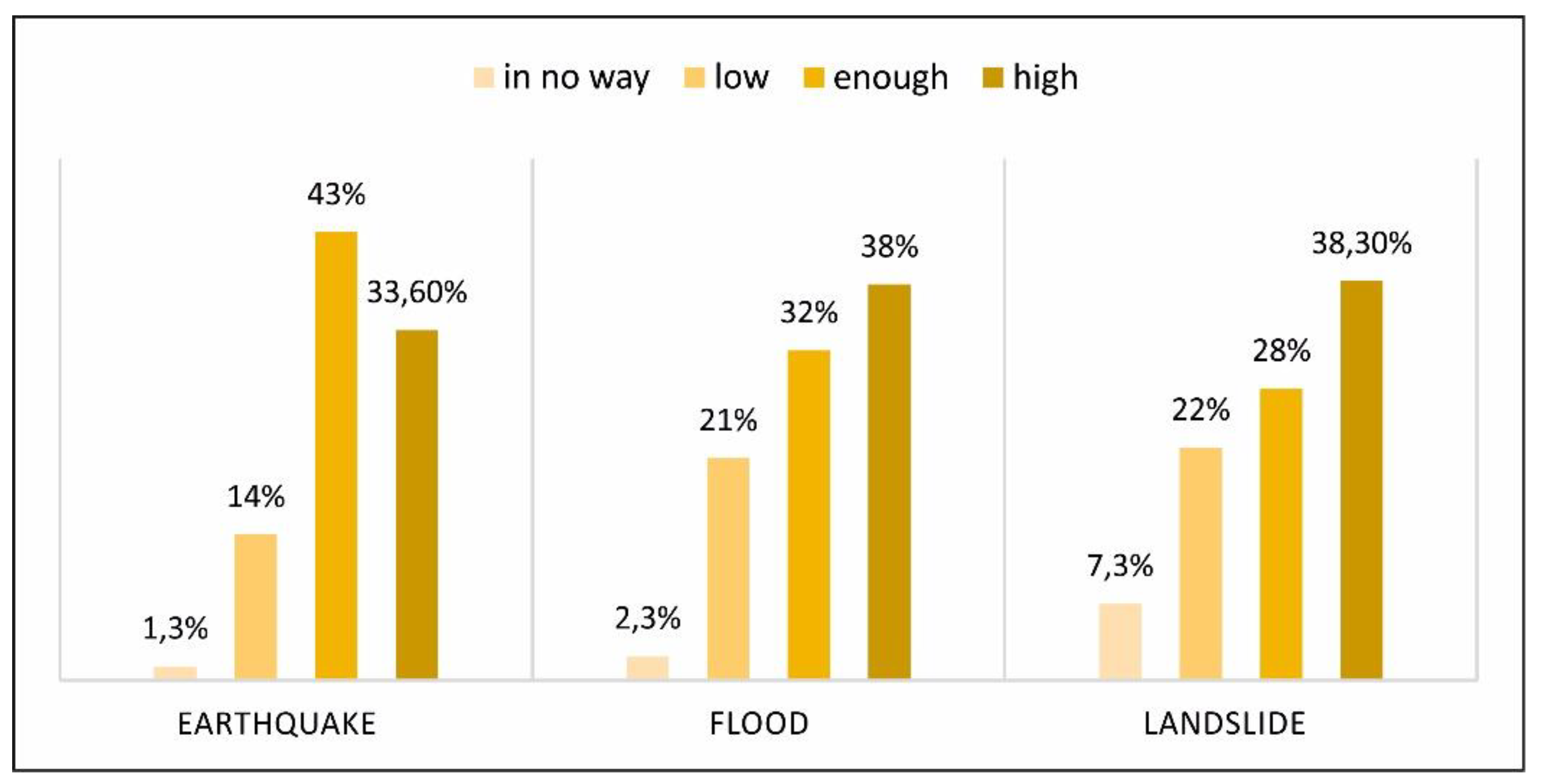
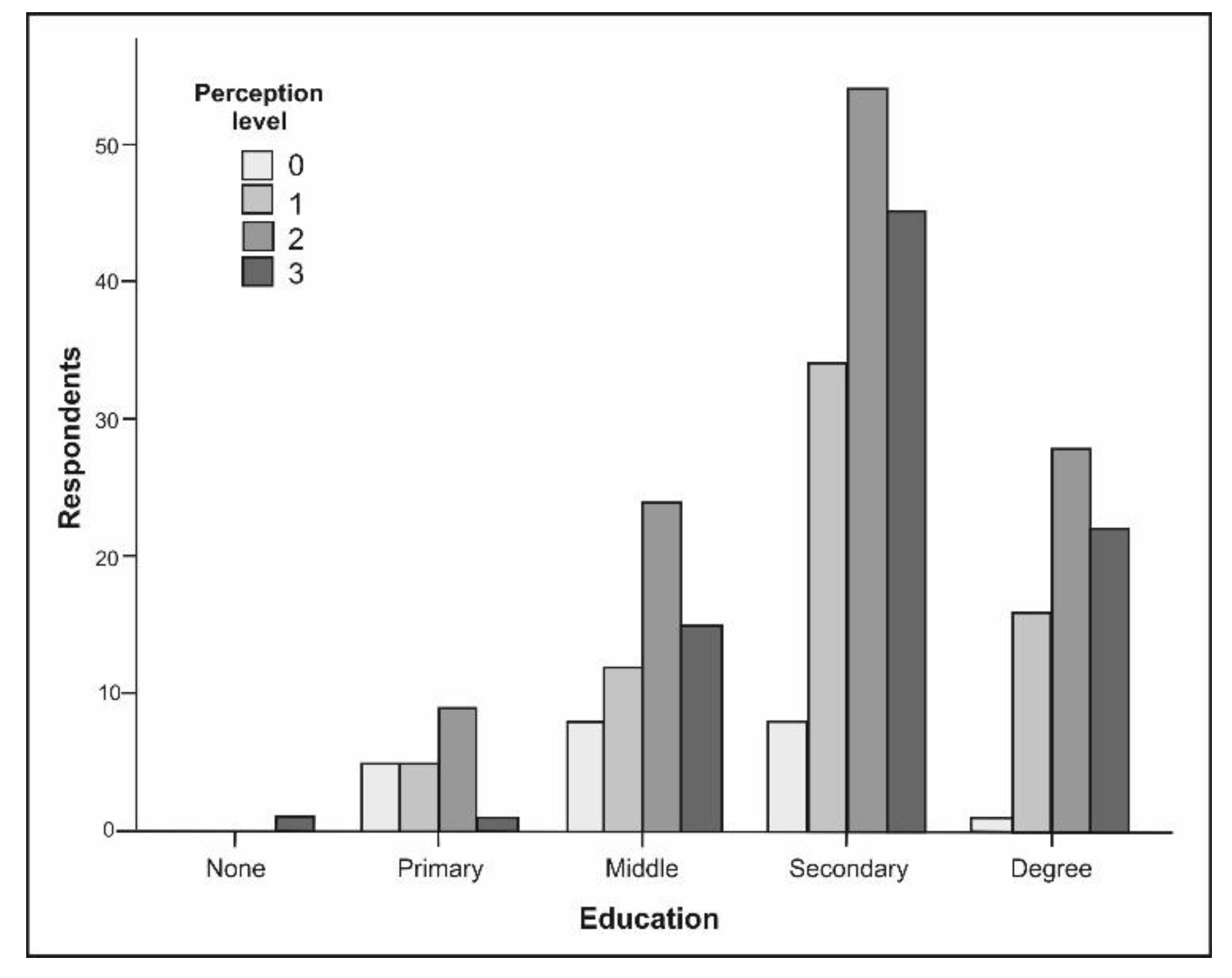
4.1. Perception of Geo-hydrological Risk, Involvement in Past Events and Behaviors Exhibited

From the answers obtained by the experts, it seems that populations underestimate the geo-hydrological risk, while also according to the experts, seismic risk perception of populations is high. The main cause for such a condition is the loss of historical memory of geo-hydrological events that affected their areas in the past. Moreover, experts believe residents are involved in other issues, mainly everyday life issues and they add that an incentive to underestimation is the belief that such geo-hydrological phenomena are unforeseeable; in some circumstances their fatalistic attitude plays a role. Experts also believe that the more the people are informed, the less they underestimate the landslide and flood risk. Moreover, experts believe that solidarity is still a value for the population and, above all when they have to face an event/problem affecting the whole community. They also underline that in the 2009–2011 events, the population did not hinder the operations of authorities in emergency situations, and indeed they actively participated in them. Vice-versa, after those events, almost nothing changed in terms of safeguard of the territory by the people. Only old people living in farming areas feel the need to comply with obligations and perform some maintenance (cleaning of drainage canals, rebuilding of small supporting walls, etc.).
The survey carried out through the questionnaire demonstrated that the population has a high level of risk perception related to landslide, flood and earthquake, that could occur where they live/work (Figure 3).
As it could be inferred from Table 1, the perception of exposure to landslide and flood risk seems to be associated to the knowledge of such phenomena, even if the test is significant only for landslides. In this case, in fact, 70.1% of those who admitted to know about landsliding phenomena show a high or very high level of risk perception as against 0% of those who admit not to have any knowledge of these phenomena.
Table 2 summarizes the results obtained by the statistical tests, with indication of significance, and it clearly shows that the level of perception of exposure to landslide, flood and earthquake risks is negatively correlated to the age of the respondents, even if such a correlation is significant only for landslide risk. Table 2 also highlights that the level of perception of risk exposure to landslides, flood and earthquake is positively correlated (significantly for landslides and earthquakes) with respondents’ level of education. Figure 4 shows such a correlation with landslide risk in detail.
About 45% of the interviewed population considers the probability of landslides and floods in the place where they live as high and 54% considers the probability that such events cause damage to people and/or property high. Respondents attribute the probability of damages for such events as a consequence of: lack of ad-hoc actions for natural hazard protection, house development in hazard areas and lack of information. Citizens seem enough worried for the risk of potential physical damage to themselves or to members of their families (71%), material damage to their dwellings (63%) and the stress in the family (58%), (Figure 5).
The most frequent answer to the question: “According to you, are landslides and floods events, …” was “Caused by man” (222 out of 300) followed by, “natural” (119), “foreseeable” (106), “unforeseeable” (76). Only 9 people thought that these events are “caused by a divine punishment”: almost all of them were over 60 and all retired.
As to the historical memory, 68% of respondents knows that landslides and floods occurred in the area where they live/work, while only 7% does not remember the events occurred in the 2009–2010 period. Such data is confirmed in Table 2, which shows an association between people’s involvement in past geo-hydrological events and the perception of risk exposure to such events, even if it is significant only for floods. Figure 6 shows the results of such an association for flood risk. Again, Table 2 shows significant association only between the perception of flood risk exposure and respondents’ involvement in the 2009–2011 events. The citizens involved remember the difficulties caused by the block of important communication roads and the suspension of service provisions such as water, power and telecommunication supply; they also remember the damages suffered by their own property. As regards the multiple-choice question about the behavior during the 2009–2011 events, the most frequent answer from the respondents was “I tried not to panic” (49 answers out of 300), followed by “I tried to get information about the situation through...”(39 answers), “I tried to help close people” (30 answers); the latter was a great example of sense of belonging to the community. Table 2 shows association between the feeling of local belonging and the perception of geohydrological risk exposure. Instead, Table 2 also shows that there is no statistically significant correlation between citizens whose place of residence falls into the areas involved in the events of 2009–2011 and their perception of exposure to geohydrological risk.

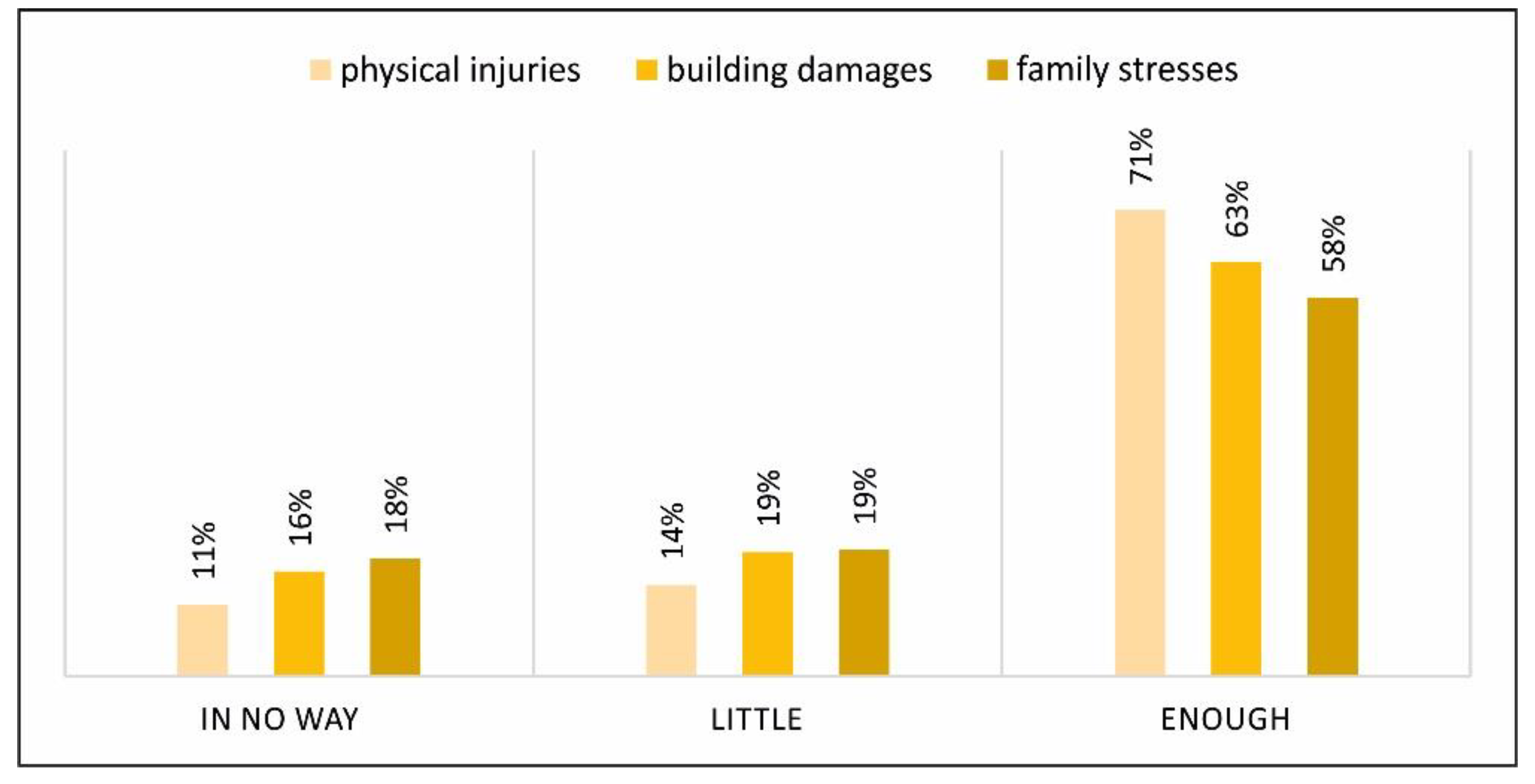
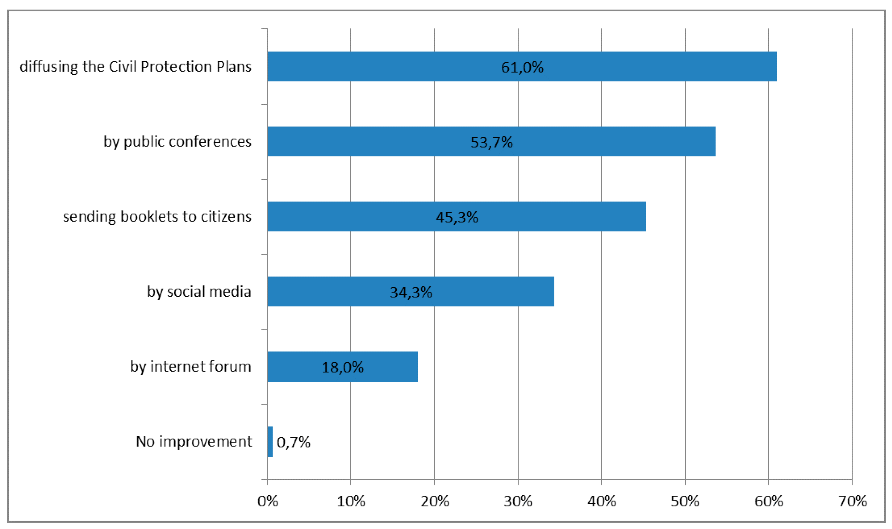
4.2. Information, Communication, Preparedness, Feeling of Safety

Interviewed experts admitted that ad-hoc awareness campaign on the geo-hydrological risk in the areas had never been carried out. Only schools had organized practical exercises on the risk of earthquake or tsunami, in which several students participated. According to experts, people are not interested in participating in information/training activities on the geo-hydrological risk in that, as indicated before, they underestimate the risk. In fact, some of the respondents affirmed that when an open event was organized to illustrate the Municipal Civil Protection Plan (Piano Comunale di Protezione Civile—PCPC) of one of the municipalities under investigation, the participation of the community was very limited. As to the PCPC, experts believe that the population is not even informed about the existence of such tools. As a consequence, the experts maintain, people are not at all ready to face a potentially damaging geo-hydrological event with the only exception of young generations, because of the information/training campaign carried out in schools. Interviewed experts believe that the population thinks that risk prevention activities (preparedness and information), along with risk management is an exclusive task of the competent authorities, and in particular of the Municipality where citizens work or live. In their opinion, the explanation for that is the predominantly welfarist cultural attitude. Experts underline that people, in general, do not trust institutions apart from the municipality where they live; they also believe that only well-educated people trust national bodies, such as the firefighters.
The survey carried out through the questionnaire, showed that 60% of the citizens feels they are not enough prepared to face a geo-hydrological event in the area where they live/work; 23% is fairly prepared and only 14% is well prepared. The main answer provided by respondents who did not feel enough prepared (the reasons for their evaluation) was the lack of information and awareness-raising by institutions. 14.7% of residents, who feel prepared to face a geo-hydrological event in the area, are those who: (i) have already faced the experience of a landslide or flood (in some cases because of their jobs), (ii) are prepared thanks to their own initiative, (iii) believe they live in a safe area and, (iv) have a resilient nature (will, agility, survival instinct and practical sense). Those who feel themselves more resilient or prepared to face hazard are also those who do not show any psychological problems (Post-Traumatic Stress Disorder) when thinking about a geo-hydrological event. The fear for psychological damage decreases with an increased level of personal preparedness, even if such a correlation is not statistically significant ( τ b = −0.083; p-value = 0.111).
As to the Municipal Civil Protection Plan (PCPC) the majority of residents (78.3%) knows that it is a tool that should be used to raise awareness among the citizens about the hazards in the area where they live. However, when respondents were asked questions about the PCPC, only 6.3% of respondents answered they knew about it and that they had read it, 16% said they knew what it was but had not read it, 15.7% believes the municipality did not develop it and, finally, 62% ignores whether the municipality has developed it or not.
Almost half of the respondents (46.7%) thought that the responsibility for preparedness and information in case of events such as landslides and floods is both personal and institutional, thus showing great civic sense, while 30% and 11.3% considered institutions as the main responsible and the sole responsible, respectively.
About 44% of the community believes they are well informed about whether conditions, alert and geo-hydrological risks. The most widely used channels for this update were “Weather web sites” (190 out of 300) and “TV” (189). Nonetheless, almost all of them believe that communication on geo-hydrological risk between the competent authorities and the citizens should be improved, above all through the diffusion of the PCPC (61%), awareness spreading and involvement of the citizens in conferences and training initiatives (53.7%) and information pamphlet sent to citizens (45.3%), Figure 7.
About 50% of respondents affirmed they were not aware if works to reduce the hydro-geological risk in their area had been implemented, 27.3% was sure there were none and, finally, 23.7% affirmed they knew about their existence. In particular, the last group mentioned hydraulic works. However, some were convinced that such works are not a solution, they are indeed even detrimental and spoil the landscape.
Finally, as to reliability, in case of hydro-geological event, the community would mainly rely on their families and relatives (66.7%), followed by firefighters (64.7%), civil protection operators (60%), police officers (55%), and friends/neighbors/colleagues (50.3%). Data show that more than half of respondents did not trust public administrations (55%). Some citizens made a distinction when assessing the actions/initiatives of firefighters (maximum score of reliability) as compared to those of the civil protection (minimum score of reliability). A high percentage of respondents did not consider public administrations as reliable entities in case of landslides or floods.

5. Discussion

The results presented and the comparison among the responses collected in semi-structured interviews to the so-called experts, and those obtained through the questionnaire administered to citizens, highlighted a gap and lack of accord between the two samples in the majority of the research topics.

5.1. Risk Perception, Past Experiences and Behavior Adopted during the Geo-hydrological Events

First of all, citizens show a high level of perception of their exposure to both geo-hydrological and seismic risk; moreover, they consider the probability that landslides and floods may occur in their area as high and they are worried such phenomena might cause physical injuries to their families and damages to their property. The perception of exposure to risk coming from landslides, floods and earthquakes is positively related (and significantly for landslide and earthquake risks) with the level of education of respondents. Several studies have found that the most educated people have a more accurate perception and awareness of the risk as they more easily understand the scientific complexity of the natural hazards and are more skilled in the search and acquisition of information [59,60,61]. In a study that investigated the natural hazards knowledge and risk perception in the village of Fazhi in the Central Mountain Range of Taiwan, education has proved to be an influential factor in the perception of landslides, debris flow and flood risks [62].
However, interviewed experts show a certain level of concern when they affirm (complain) that local residents have low perception of their exposure to geo-hydrological risk, because of their loss of historical memory on past events combined with a fatalist attitude and the belief that such phenomena are unforeseeable. Mary Douglas, the founder of the Cultural Theory along with Aaron Wildavsky [63] dealt with the concepts of pragmatism and fatalism and they affirmed that the moral and political aspects are the first factors affecting risk perception among citizens. As the study on the perception of seismic risk in Italy carried out by Crescimbene and La Longa [64] pointed out, citizens do not easily get rid of a fatalistic behavior that lasted over millennia and finds its roots in the religious culture.
The divergence between the opinion of the experts and the perception of citizens on this issue is furtherly confirmed by the citizens’ answers provided on the questions about the memory of past events: almost all respondents remember, in fact, the 2009–2011 events and the consequent inconveniences. In particular, the significant association only between perception of exposure to flood risk and the involvement in the 2009–2011 events, shows that residents consider recent debris flow events essentially as alluvial events. One of the causes of this significant association could be that debris flows occurred as a consequence of particularly heavy, despite not extreme, rainfalls. The association between landslide and flood risk perception, along with the past experiences of citizens, was also found in other research and case studies. For example, a research carried out in Rio de Janeiro on the perception of landslide and flood risks among the population, found that the perception of such risks is mainly influenced by past experiences, as compared to other factors [65]. Also, in this case study, the perception of the population about flood risk was much more concrete than their perception of landslide risk due to heavy rainfall. A significant influence of past experiences on the perception of landslide and flood risks was also found in some previous studies carried out in Colorado, Switzerland and New Zealand [66,67,68]. Since the adoption of measures to manage and prevent risks differentiate based on the phenomena associated with them, it is fundamental for citizens to understand the type of disaster which they could incur in. In particular, for this case study, it is vital for citizens to understand that landslides represent a serious risk in the area where they live/work.
Moreover, while experts believe that the population maintains a fatalistic attitude towards disasters, citizens’ awareness on the importance of anthropic impacts on the occurrence of disasters related to landslides and floods is increasing; instead, the belief that disasters are caused by divinity punishments is diminishing.
Therefore, summarizing the comparison between experts and citizens on the issues of risk perception, the experiences and the behavior adopted during the geo-hydrological events, experts believe that citizens have a low perception of landslide and flood risk because these phenomena are considered to be unpredictable, also for a fatalistic vision motivated by a resigned passivity towards this type of events. Furthermore, according to the experts, citizens have no memory of the geo-hydrological events that occurred in the past in their territory. Instead, they show a high level of perception of landslide and flood risk and also remember that their territory has been hit in the past by geo-hydrological events; the analysis of the results shows, among other things, a significant association between the perception of exposure to flood risk and the involvement in past geo-hydrological events by the interviewees.
Moreover, as already pointed out, the interviewed population seems to move away from a fatalistic attitude, which would attribute, precisely, to the fate or to the divinity the cause of the disasters. Instead, citizens’ awareness about the influence of human factors is increasing, interacting with a destructive agent such as an earthquake, a tsunami, a hurricane or extreme rainfalls, as these extreme events could turn into disasters. Among the anthropic factors most reported by the citizens, there is the illegal construction, a significant social scourge of this territory [27]. It would therefore be an urgent measure to avoid forms of illegal construction, a recurrent feature of this territory, which makes it more fragile and vulnerable to the occurrence of extreme events. On this fundamental point we should foresee a commitment of the whole community, administrators, stakeholders and citizens included, so that the risk areas are planned in a sustainable, resilient and consistent way with ethical principles.
An aspect on which experts and citizens agree is, instead, the opinion on the behaviors adopted by the population during the events of the three-year period 2009–2011. In fact, everyone agrees on the solidarity and composure of the population demonstrated during the emergency. In fact, the citizens did not panic but helped people in need. This data is also confirmed by the positive correlation between the perception of landslide risk and the feeling of local belonging of the interviewed population. The experts rather have complained about the lack of care of the territory by citizens in periods outside the emergency situations, with the sole exception of the elderly. As a culture of prevention in the population is lacking, during the periods pre- and post-emergency, the competent authorities and the institutions should be engaged in the prevention and planning of the future emergency and in the promotion of training and information initiatives on the geo-hydrological risk among the population [20].

5.2. Preparedness, Information and Communication

Another aspect on which the perception of experts and citizens coincide is that of preparedness. Everyone agrees that the population and especially the elderly are not sufficiently prepared to face a new hydrogeological event. Another figure gives reason to the experts is related to their opinion that the more the population is informed, the less the risk is undervalued. In fact, this is confirmed by the positive correlation, emerged in the statistical analysis, between the level of education of the interviewees and the perception of exposure to landslide, flood and earthquake risks. Furthermore, as highlighted by Ahsan and Warner [69], the level of education not only influences the perception of risk, but also the ability to access, understand and know how to discriminate information. In addition to this, the results obtained from questionnaires point out the role of schools and of basic education on natural hazards whose contribution is even greater than university education, probably because the latter is not always based on scientific education and environment.
The high perception of seismic risk by the population, reported by experts, was also confirmed by the analysis of citizens’ responses. Also, in the research carried out by Salvati et al. [70] in Italy, on a national scale, the interviewees felt most exposed to earthquakes followed by flooding, landslides and volcanic eruptions.
Another important topic is that of information and communication. From this point of view, a contradiction emerged on the role of risk communication between experts and the population. In fact, on one side, the majority of citizens affirms that the responsibility for preparedness and information in case of events such as landslides and floods is both personal and institutional, showing high civic sense. Moreover, they feel that communication between competent authorities and citizens on the issue of geo-hydrological risk should be improved. On the other side, however, in the opinion of experts, citizens do not always participate in the information and preparedness events organized for the population.
Moreover, by analyzing the results of the section of the questionnaire on PCPC, great ignorance is noted among the community as to the existence of a PCPC in the municipality. In fact, the majority of citizens knows what a PCPC is, i.e., “a tool that should be disseminated to make citizens aware of the risks of their territory”, but they ignore whether their Municipality has one or not. From this point of view, experts affirm that citizens are not interested in participating in educational events, thus underestimating the geo-hydrological risk of the territory, and that they do not have any idea about what the PCPC is. As a consequence, according to expert, people do not know how to behave in extreme natural events and attribute responsibility for their preparation exclusively to administrators, thus showing a widespread welfarist attitude. This last opinion does not coincide with that of the population, according to which responsibility for preparation and information is to be attributed to both citizens and administrators. It is evident, in this context, that the lack of communication of the content of the PCPC is a responsibility of the municipal administration, which should be more committed to implement effective strategies to make people aware of the risk and to disseminate the PCPC, in line with the regional government guidelines. However, as Rufat et al. [71] pointed out, the provision of official flood information by governments can increase awareness, but it is insufficient to result in reduced social vulnerability. In fact, it is important to underline that the people should show greater attention towards the initiatives developed in an area and towards the problems of such areas; they should also receive ad hoc stimuli to autonomously look for specific information at the institutional level. An effort in this sense was made by a group of citizens, who proactively contacted the municipality (immediately after the interviews) to ask the person in chargewhether they had a PCPC.

5.3. Evaluation of the Trust Relationship between Citizens and Experts

Finally, the discrepancy in the evaluation of the trust relationship between citizens and experts should be noted; it emerged also from the fact that the few interviewed citizens, who are prepared to face a geo-hydrological event, affirm they are prepared to it only thanks to their own personal initiative or their psychological resilience. The divergence is clear when experts affirm that citizens only trust local authorities (mayor etc.) and the firefighters. On the contrary, citizens’ answers underlined their trust in the action of the firefighters and civil protection units, while they display a low level of trust in local administrations, above all in cases of landslides or floods. The high reliability and trust of the fire fighters by residents is possibly a consequence of the fact that they have satisfactory knowledge of the territory and are trained to face emergencies. The lack of faith in municipal administrations is, as it was inferred from the answers provided by the citizens in the questionnaire, a consequence of the lack of interest displayed by local administrations towards the problems of the territory. Various investigations demonstrate how disadvantaged groups unduly suffer due to governmental neglect of unique needs during disaster planning [72].
Therefore, from this framework a divergence of opinions and visions between local policy makers and citizens on the issues dealt with emerges, as a result of which, a closer approach of the local policy-makers to the problems of citizens would be appropriate and necessary. At the same time, a greater need emerges for citizens to participate in public life and in the decision-making processes of their municipality concerning Disaster Risk Reduction policies.
Even in a well-organized community in terms of prevention, such as the Japanese community, the results of a case study on the citizen’s perception on municipal plans to host disaster waste suggest that the national and municipal governments should communicate more with the public about the risks of the territory and carry out some initiatives to improve public trust in the national government [73].
Also, in terms of risk mitigation measures implemented in the study area, only a few citizens are aware of such measures and they do not consider them as permanently useful, rather even dangerous and spoiling for the area. In fact, prevention cannot be carried out exclusively through an engineering project, without considering the complexity of the environment in which it is inserted [74]. Thus, this situation highlights the need for a change from a top-down to a bottom up approach, based on which the population should be proactively involved in urban planning and citizens’ participation in the decision-making process should be encouraged. An inclusive governance process appears to be a further contribution to risk prevention and adaptation. By implementing direct action with and in the territory and sharing the urgency and importance of prevention, it allows for an effective response to states of emergency [74].

6. Conclusions

In line with the Sendai Framework for Disaster Risk Reduction (SFDRR) requirements [29], empowering local institutions to play more roles and implementing a “bottom-up” approach to community-rooted interventions will boost disaster risk reduction. A bottom-up approach in the application of local actions and measures is essential for achieving long-term goals and social support [75,76,77,78]. Starting from this presupposition, the following considerations emerge from the analysis of the results of this case study:
  • The communication gap between experts and people highlighted by the case study leads us reflect on the following: the need for local authorities and experts to set the conditions to disseminate the culture of awareness on the risks of an area, and to increase the level of safety of a specific territory by concrete and participated actions (bottom-up approach).
  • However, communication on natural hazards not only means informing citizens, but also assessing whether citizens understood the content of the communication. In fact, whoever communicates should necessarily be “aware” and informed about the community’s needs and requirements, as well as their level of understanding. It is fundamental to know what the population perceives and what type of information citizens need. Also, it is important to relate such information to the specific geo-hydrological risk of the area. In fact, since actions to prepare, prevent and adapt measures are based on the natural phenomena themselves, it is mandatory for the population to be clearly informed about the risks to which they are exposed.
  • One of the main obstacles for decision-makers is therefore the lack of resources to put knowledge into practice and the lack of incentives in order to improve the decision-making process and reduce the knowledge gap between experts and citizens. Greater synergy is needed among local policy-makers, stakeholders, experts and citizens to identify together appropriate solutions in order to face the criticalities of the territories. Van Well et al. [79] praise the virtuous example of the Nordic Centre of Excellence on Resilience and Societal Security network, which includes Denmark, Finland, Iceland, Norway and Sweden. It is grounded on the vision that societal resilience and security are based on the synergy of communities, institutions, individuals and infrastructures.
  • Even if further detailed analyses are needed, in this Italian case study it is already clear that future scenarios regarding risk perception and indirectly public vulnerability also depend on the education policies carried out in the near future. Given the protective effects that education can have in the various phases of a disastrous event (pre-, during and post-), it is clear that investment in public education can have positive effects in reducing the vulnerability of the population and enhancing their adaptive capacity. Disaster risk reduction policies must be integrated into formal education and national training and development programs. This is related to the commitment of governments and the adoption of an institutional basis for the transmission of experience [80]. Increasing citizens’ education through training and communication between institutions and citizens builds the resilience of a territory, which is precisely built through greater interaction among the individual, society and the environment.
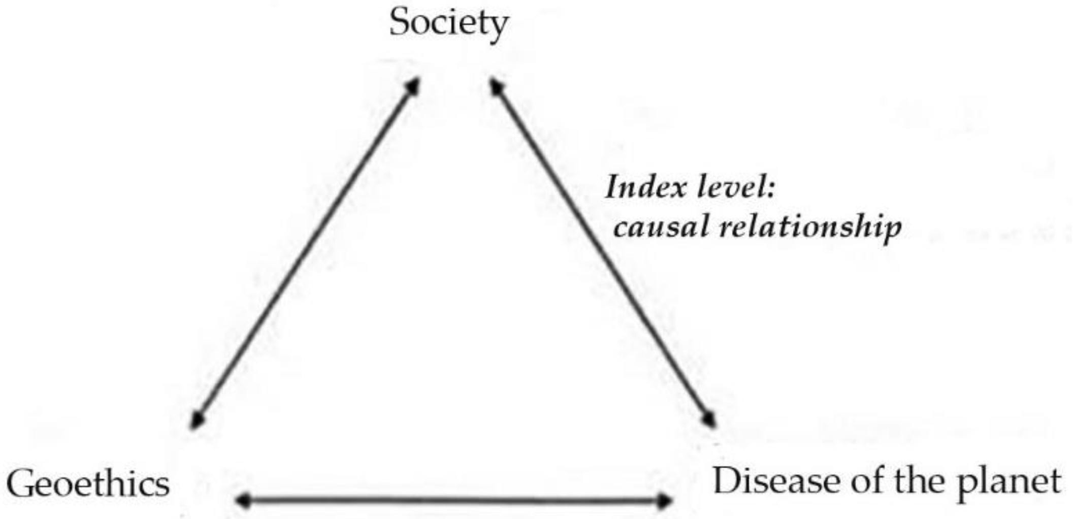
  • It is necessary to avoid forms of illegal building, which contribute to increasing the risk of disasters. The risk, in fact, as can be inferred from the analysis of the triangle mentioned above, is generated in the context of the structural problems of societies and of social vulnerability, and the solutions shouldn’t be sought only in reducing the hazard. For example, the dissemination of geoethics could help provide the correct categories to discuss prevention in the area. The case study in question shows, in fact, the institutional incapacity, both nationally and locally, to replace the emergency intervention method with a culture of risk and disasters, building knowledge, forecasting and prevention paths that could help people potentially involved in developing effective solutions based on an awareness of these phenomena (e.g., [81]).
  • The use of an integrated approach of urban political ecology focusing on the connection between political, social, economic and ecological issues to provide solutions to contemporary environmental challenges [82,83,84] could clarify the underlying causes, impacts and solutions to risk and vulnerability with respect to a conventional assessment method [34].
Above all, increasing social support would mean adopting measures to reduce social vulnerability factors that have emerged in this research. In the context of the 17 Sustainable Development Goals (SDGs),adopted by the United Nations Member States in 2015 [85], we selected three goals that best set out the type of recommendations that arise from this research: ensure inclusive and equitable quality education and promote lifelong learning opportunities for all; make cities and human settlements inclusive, safe, resilient and sustainable; promote peaceful and inclusive societies for sustainable development, provide access to justice for all and build effective, accountable and inclusive institutions at all levels [85].
In fact, policies aiming at education and human capital formation seem to be the most efficient strategies to promote vulnerability reduction and enhance the adaptive capacity of population.

Author Contributions

Conceptualization, L.A., R.C., F.D.P.; data curation, R.C.; formal analysis, F.C.; investigation, F.D.P.; methodology, L.A.; specifically, F.D.P. wrote paragraphs 1, 2 and 5.3; L.A. wrote paragraphs 3.1, 3.2 and 5.1; R.C. wrote the Section 4 and paragraph 5.2. L.A., F.D.P, R.C. wrote paragraph 6.

Funding

This research received no external funding.

Acknowledgments

The authors would like to thank participants who gave their voluntary and informed consent before the interviews.

Conflicts of Interest

The authors declare no conflicts of interest.

Appendix A

The topics and the open questions of semi-structured interviews administered to the experts and the 26 queries of questionnaire submitted to residents.
Table A1. Semi-structured interviews submitted to experts.
TopicsOpen Questions
1. Perception of exposure to geohydrological risk of populationQ.1 Based on your experience do the people in the community feel themselves exposed to risks? Are they worried that landslides and floods could affect their village, house or their own lives or their relatives lives? Or, do you think they are more worried about the effects of an earthquake?
Q.2 In your opinion, what is the cause of hydro-geological risk for population in the area where it live? (illegal constructions, fatality, fault of the Local authorities, etc.?)
Q.3 In your opinion, do people underestimate hydro-geological risk? And what is the reason for that? Unfrequent events, loss of the historical memory, unforeseeable events, specific interests of false security?
2. Experience of geohydrological phenomena of population and behavior exhibited Q.4 According to you does the community keep itself informed, generally speaking? And what media does it manly employ? (TV, radio, social networks etc.)
Q.5 Do the people in the community help each other? (sense of solidarity)
Q.6 Could you briefly describe what happened during the rapid flows that invaded some areas of the municipality and carried water, earth and cobbles in the 2009–2011 period? How did people behave? Did the authorities meet difficulties/hindrances in the behavior of people in the 2009–2011 events?
Q.7 Did life in the community change after those events? Is there greater respect for the territory where the community lives? Do people accept the limits to private property/economic and productive activities present on such risk areas? Do they consider such limits as too rigid?
3. Information, communication, preparedness Q.8 Have training and information activities on the hydro-geological risks ever been organised? (public meetings, drills etc.) and, if so, how did the population participate? In case they were not organized what could the response of the community be towards such activities?
Q.9 In your opinion, are the people sufficiently informed about the existence of the Plan for Civil Protection of the Municipality and its content? Are the people in the community sufficiently prepared to face a hydro-geological event? Do they possess self-protection skills?
4. Feeling of safety/trustQ.10 Is the welfarist attitude disseminated in the community? Do people believe that risk and emergency management activities are ONLY a responsibility of the competent authorities?
Q.11 In your opinion, do the people in the community trust the Entities that carry out civil protection tasks? (Municipality, Regional Government, Fire brigade, Voluntary Associations). What is the most trusted Entity?
Table A2. Standardized questionnaire submitted to population.
SectionQueriesResponse Format
Sociodemographic characteristicsQ.1 Age-Open-ended question
Q.2 What is your educational qualification?-Degree
-Secondary education
-Middle school education
-Primary education
-No title
Knowledge of geohydrological phenomenaQ.3 Do you know what is a landslide?-Yes/No
Q.4 Do you know what is a flood?-Yes/No
Q.5 In your opinion, landslides and floods are events. [multiple responses allowed]-Foreseeable
-Unforeseeable
-Caused by a divine punishment
-Natural
-Caused by man
Experience of geohydrological phenomenaQ.6 Do you know if a landslide occurred in the place where you live/work?-Yes/No
Q.7 Do you know if a flood occurred in the place where you live/work?-Yes/No
Q.8 In 2009, 2010, and 2011 in … (name of municipality) … occurred several debris flows and inundations. Were you (or your relatives) involved in these events?-Yes/No
-I don’t remember these events
Q.9 If you answered “yes” to the previous question, what type of damage have you suffered? [multiple responses allowed]-Physical injuries
-Damages to properties
-Damages to main roads
-Facility interruptions
Q.10 Your behaviours during the events were … [multiple responses allowed]-I tried to get information about the situation through TV, social network, internet, radio, neighbors
-I tried not to panic
-I tried to help close people
-I accepted it as an inevitable situation
-I trusted in God
-I remained indifferent
Perception of risk posed by adverse eventsQ.11 How much do you feel exposed to each of these events in…(name of municipality)? [5-level scale: in no way, low, enough, high, I do not know] -earthquake
-flood
-landslide
-environmental pollution
-car accident
-tsunami
-volcanic eruption
-terrorist attacks
Q.12 In your opinion, the probability that in the place where you live or work a geohydrological event occur is … [5-level scale: in no way, low, enough, high, I do not know]-Five point scale
Q.13 If you estimate “high” the probability that a geohydrological events, can you explain why?-Open-ended questions
Q.14 If you imagine the occurrence of a geohydrological event (landslide, flood) how worried are you about the possible consequences in terms of … [5-level scale: in no way, low, enough, high, I do not know]-physical injuries
-building damages
-damages at work
-psychological problems
-family stresses
-people stresses
Information and preparedness to geohydrological riskQ.15 Presently, how you rank your information level about geohydrological risk in the place where you live or work? [5-level scale: in no way, low, enough, high, I do not know]-Five point scale
Q.16 In your judgment, the Municipal Civil Protection Plan is...-a technical tool only for competent authorities
-a tool that should be disseminated to make citizens aware of the risks of their territory
-I don’t know
Q.17 Has your municipality prepared a Civil Protection Plan?-Yes and I know its contents
-Yes but I do not know its contents; It was never done
-I don’t know if it exists
Q. 18 Are you aware of any works built in this area as protection from geohydrological phenomena? -Yes (specify…)
-There are none
-I don’t know
Q.19 Presently how informed do you feel about weather conditions and weather alerts?-Five point scale
Q.20 What are your main information sources? -Newspapers
-Radio TV
-Internet and social network (Civil Protection of Calabria Region, Regional Agency for Environment in Calabria, etc.);
-Weather web sites
Q.21 In your opinion, the responsibility for education and information in case of events such as landslides and floods is…-only mine
-mainly mine
-mine and of the institutions
-mainly of the institutions
-only of the institutions
-I don’t know
Q.22 If a geohydrological event should take place in the place where you live or work, how well prepared do you feel to face it? [5-level scale: in no way, low, enough, high, I do not know]-Five point scale
Q.23 If you think this about your personal preparedness, can you explain why?-Open-ended questions
Geohydrological risk communicationQ. 24 Please evaluate how communication on geohydrological hazards between the competent authorities and the citizens can be improved [multiple responses allowed]-No improvement
-Involvement of the citizens in conferences and training initiatives;
-Social media
-Internet forum
-Information pamphlet sent to citizens
-Diffusion of the PCP
Feeling of safety/trust and local belongingQ.25 If a geohydrological event should take place in the place where you live/work, whom would you rely upon to decide what to do? -Police
-Firefighters
-Civil Protection
-Public administrations
-Voluntaries
-Friends, neighbors, colleagues
-Family and relatives
Q.26 Do you consider … (name of municipality), your hometown?-Yes/No

References and Note

  1. Guha-Sapir, D.; Vos, F.; Below, R.; Ponserre, S. Annual Disaster Statistical Review 2011: The Numbers and Trends; CRED: Brussels, Belgium, 2012; Available online: http://www.cred.be/sites/default/files/ADSR_2011.pdf (accessed on 15 March 2019).
  2. Hoeppe, P. Trends in weather related disasters—Consequences for insurers and society. Weather Clim. Extremes 2016, 11, 70–79. [Google Scholar] [CrossRef]
  3. Ritchie, H.; Roser, M. Natural Catastrophes. Published online at OurWorldInData.org. 2018. Available online: https://ourworldindata.org/natural-catastrophes (accessed on 2 February 2019).
  4. Emmer, A. Geographies and Scientometrics of Research on Natural Hazards. Geosciences 2018, 8, 382. [Google Scholar] [CrossRef]
  5. Diakakis, M.; Priskos, G.; Skordoulis, M. Public perception of flood risk in flash flood prone areas of Eastern Mediterranean: The case of Attica Region in Greece. Int. J. Disaster Risk Reduct. 2018, 28, 404–413. [Google Scholar] [CrossRef]
  6. Rego, I.E.; Pereira, S.M.; Morro, J.; Pacheco, M.P. Perceptions of seismic and volcanic risk and preparedness at São Miguel Island (Azores, Portugal). Int. J. Disaster Risk Reduct. 2018, 31, 498–503. [Google Scholar] [CrossRef]
  7. Brooks, N.; Adger, W.N.; Kelly, P.M. The determinants of vulnerability and adaptive capacity at the national level and the implications for adaptation. Glob. Environ. Chang. 2005, 15, 151–163. [Google Scholar] [CrossRef]
  8. Dowling, C.; Santi, P. Debris flows and their toll on human life: A global analysis of debris-flow fatalities from 1950 to 2011. Nat. Hazards 2014, 71, 203–227. [Google Scholar] [CrossRef]
  9. Toya, H.; Skidmore, M. Economic development and the impacts of natural disasters. Econ. Lett. 2007, 94, 20–25. [Google Scholar] [CrossRef] [Green Version]
  10. Samir, K.C. Community Vulnerability to Floods and Landslides in Nepal. Ecol. Soc. 2013, 18, 8. [Google Scholar] [CrossRef]
  11. Kc, S.; Lutz, W. Demographic scenarios by age, sex and education corresponding to the SSP narratives. Popul. Environ. 2014, 35, 243–260. [Google Scholar] [CrossRef]
  12. Paul, B.K.; Bhuiyan, R.H. Urban earthquake hazard: Perceived seismic risk and preparedness in Dhaka City, Bangladesh. Disasters 2010, 34, 337–359. [Google Scholar] [CrossRef]
  13. Ainuddin, S.; Routray, J.K.; Ainuddin, S. People’s risk perception in earthquake prone Quetta city of Baluchistan. Int. J. Disaster Risk Reduct. 2014, 7, 165–175. [Google Scholar] [CrossRef]
  14. Chowdhury, P.D.; Haque, C.E.; Driedger, S.M. Public versus expert knowledge and perception of climate change-induced heat wave risk: A modified mental model approach. J. Risk Res. 2012, 15, 149–168. [Google Scholar] [CrossRef]
  15. Bradford, R.A.; O’sullivan, J.J.; Van Der Craats, I.M.; Krywkow, J.; Rotko, P.; Aaltonen, J.; Bonaiuto, M.; De Dominicis, S.; Waylen, K.; Schelfaut, K.; et al. Risk perception—Issues for flood management in Europe. Nat. Hazards Earth Syst. Sci. 2012, 12, 2299–2309. [Google Scholar] [CrossRef]
  16. Chowdhury, P.D.; Haque, C.E. Risk perception and knowledge gap between experts and the public: Issues of flood hazards management in Canada. J. Environ. Res. Dev. 2011, 5, 1017–1022. [Google Scholar]
  17. Qasim, S.; Khan, A.N.; Shrestha, R.P.; Qasim, M. Risk perception of the people in the flood prone Khyber Pukhthunkhwa province of Pakistan. Int. J. Disaster Risk Reduct. 2015, 14, 373–378. [Google Scholar] [CrossRef]
  18. Chipangura, P.; Van Niekerk, D.; Van Der Waldt, G. Disaster risk problem framing: Insights from societal perceptions in Zimbabwe. Int. J. Disaster Risk Reduct. 2017, 22, 317–324. [Google Scholar] [CrossRef]
  19. Italian Law n. 225 of 24 February 1992, Sector: National Legislation, Matter: 17. Natural disasters, Chapter: 17.1 Declarations of natural and exceptional disaster: Establishment of the National Civil Protection Service, Gazzetta Ufficiale della Repubblica Italiana, n. 64 of 17 March 1992.
  20. Gugg, G. Anthropology of the Vesuvius Emergency Plan: History, perspectives and limits of a dispositive for volcanic risk government. In Natural Hazards and Disaster Risk Reduction Policies; Antronico, L., Marincioni, F., Eds.; Geographies of the Anthropocene book series; Il Sileno Edizioni: Rende, 2018; pp. 105–123. Available online: ilsileno.it/geographiesoftheanthropocene (accessed on 5 February 2019).
  21. Calandra, L.M. (Ed.) Territorio e Democrazia. Un Laboratorio di Geografia Sociale nel Dopo Sisma Aquilano; L’Una: L’Aquila, Italy, 2012. [Google Scholar]
  22. Carnelli, F.; Ventura, S. (Eds.) Oltre il Rischio Sismico. Valutare, Comunicare e decidere Oggi; Carocci: Roma, Italy, 2015. [Google Scholar]
  23. Falconieri, I. Smottamenti. Disastri, Politiche Pubbliche e Cambiamento Sociale in un Comune Siciliano; CISU: Roma, Italy, 2017. [Google Scholar]
  24. Pitzalis, S. Politiche del Disastro. Poteri e Contropoteri nel Terremoto Emiliano; Ombre Corte: Milano, Italy, 2016. [Google Scholar]
  25. Mela, A.; Mugnano, S.; Olori, D. (Eds.) Territori Vulnerabili. Verso una Nuova Sociologia dei Disastri Italiana; Sociologia Urbana e Rurale book series; FrancoAngeli: Milano, Italy, 2017. [Google Scholar]
  26. Carnelli, F.; Forino, G. Gestire un terremoto in Italia: Breve Prontuario D’emergenza Sismica, Lo Stato Delle Cose. Geografie e Storie del Doposisma. 13 April 2017. Available online: http://www.lostatodellecose.com/scritture/gestire-un-terremoto-in-italia-breve-prontuario-demergenza-sismica-fabio-carnelli-e-giuseppe-forino (accessed on 19 March 2019).
  27. Antronico, L.; Coscarelli, R.; De Pascale, F.; Muto, F. Geo-hydrological risk perception: A case study in Calabria (Southern Italy). Int. J. Disaster Risk Reduct. 2017, 25, 301–311. [Google Scholar] [CrossRef]
  28. Coscarelli, R.; Antronico, L.; De Pascale, F.; Condino, F. The Influence of Knowledge and Education in Public Risk Perception. A Case Study in Calabria (Southern Italy). Preprints 2018, 2018030218. [Google Scholar] [CrossRef]
  29. UNISDR. Sendai Framework for Disaster Risk Reduction 2015–2030; United Nations International Strategy on Disaster Reduction: Geneva, Switzerland, 2015; Available online: http://www.unisdr.org/files/43291_sendaiframeworkfordrren.pdf (accessed on 22 February 2019).
  30. Cutter, S.L.; Ismail-Zadeh, A.; Alcántara-Ayala, I.; Altan, O.; Baker, D.N.; Briceno, S.; Gupta, H.; Holloway, A.; Johnston, D.; McBean, G.A.; et al. Global risks: Pool knowledge to stem losses from disasters. Nature 2015, 522, 277–279. [Google Scholar] [CrossRef] [PubMed] [Green Version]
  31. UNISDR. Hyogo Framework for Action (HFA): Building the Resilience of Nations and Communities to Disasters; United Nations International Strategy on Disaster Reduction: Geneva, Switzerland, 2005; Available online: http://www.unisdr.org/files/1037_hyogoframeworkforactionenglish.pdf (accessed on 20 February 2019).
  32. Oliver-Smith, A.; Alcántara-Ayala, I.; Burton, I.; Lavell, A. The social construction of disaster risk: Seeking root causes. Int. J. Disaster Risk Reduct. 2017, 22, 469–474. [Google Scholar] [CrossRef]
  33. Lassa, J. Institutional Vulnerability and Governance of Disaster Risk Reduction: Macro, Meso, and Microscale Assessment (with Case Studies from Indonesia). Ph.D. Thesis, Rheinische Friedrich-Wilhelms-University, Bonn, Germany, 2010. [Google Scholar]
  34. Salami, R.O.; von Meding, J.; Giggins, H. The urban political ecology of flood vulnerability in the core area of Ibadan Metropolis, Nigeria. In Natural Hazards and Disaster Risk Reduction Policies; Antronico, L., Marincioni, F., Eds.; Geographies of the Anthropocene book series; Il Sileno Edizioni: Rende, 2018; pp. 36–50. Available online: ilsileno.it/geographiesoftheanthropocene (accessed on 7 February 2019).
  35. Oliver-Smith, A.; Alcántara-Ayala, I.; Burton, I.; Lavell, A. Forensic Investigations of Disasters (FORIN): A Conceptual Framework and Guide to Research (IRDR FORIN Publication No. 2), Integrated Research on Disaster Risk; ICSU: Beijing, China, 2016. [Google Scholar]
  36. Burton, I. Forensic Disaster Investigations in Depth: A New Case Study Model. Environ. Sci. Policy Sustain. Dev. 2010, 52, 36–41. [Google Scholar] [CrossRef]
  37. Burton, I. The forensic investigation of root causes and the post-2015 framework for disaster risk reduction. Int. J. Disaster Risk Reduct. 2015, 12, 1–2. [Google Scholar] [CrossRef]
  38. García-Acosta, V. Catastrophes non naturelles et Anthropocène. Leçons apprises à partir des perspectives anthropologiques et historiques. In Penser L’Anthropocène; Beau, R., Larrère, C., Eds.; Presses de Sciences Po: Paris, France, 2018; pp. 325–338. [Google Scholar]
  39. De Pascale, F.; Dattilo, V. La sémiosis de l’Anthropocène: pour une réinterpretation de la relation entre l’homme et la nature par le biais de la géoéthique. Riv. Geogr. Ital. 2019, 126, 23–40. [Google Scholar]
  40. De Pascale, F.; Dattilo, V. La semiosi dell’Antropocene. Riflessioni tra geoetica e semiotica a partire dal triangolo di Peirce. Filosofi(e)Semiotiche 2015, 2, 90–98. [Google Scholar]
  41. Dattilo, V. La semiosi dell’Antropocene: un approccio geoetico. In L’apporto della Geografia tra Rivoluzioni e Riforme. Atti del XXXII Congresso Geografico Italiano (Roma, 7–10 Giugno 2017); Salvatori, F., Ed.; A.Ge.I.: Roma, Italy, 2019; pp. 83–89. [Google Scholar]
  42. Matteucci, R.; Gosso, G.; Peppoloni, S.; Piacente, S.; Wasowski, J. A Hippocratic Oath for geologists? Ann. Geophys. 2012, 55, 365–369. [Google Scholar] [CrossRef]
  43. Mela, A.; Mugnano, S.; Olori, D. Socionatural disaster, resilience and vulnerability: The territorial perspective in italian current debate. Sociol. Urbana Rural. 2016, 38, 111. [Google Scholar]
  44. Valladares, R. Are we aware of our vulnerability facing socionatural disasters? Rev. Geogr. Venez. 2018, 59, 212–215. [Google Scholar]
  45. Larenas, J.A.S.; Salgado, M.A.V.; Fuster, X.S.F. Facing social-natural disasters from capital and community resources: Of Chaiten volcano eruption case, Chile. Magallania 2015, 43, 125–139. [Google Scholar]
  46. Berroeta, H.; Ramoneda, Á.; Opazo, L. Sentido de comunidad, participación y apego de lugar en comunidades desplazadas y no desplazadas post desastres: Chaitén y Constitución. Univ. Psychol. 2015, 14, 1221–1234. [Google Scholar] [CrossRef]
  47. Peppoloni, S.; Di Capua, G. Geoethics and geological culture: Awareness, responsibility and challenges. Ann. Geophys. 2012, 55, 335–341. [Google Scholar] [CrossRef]
  48. Peppoloni, S.; Di Capua, G. The meaning of Geoethics. In Geoethics: Ethical Challenges and Case Studies in Earth Science; Peppoloni, S., Wyss, M., Eds.; Elsevier: Waltham, MA, USA, 2015. [Google Scholar] [CrossRef]
  49. McClean, D. (Ed.) World Disaster Report: Focus on Urban Risk; International Federation of Red Cross and Red Crescent Societies: Geneva, Switzerland, 2010. [Google Scholar]
  50. Trigila, A.; Iadanza, C.; Bussettini, M.; Lastoria, B.; Barbano, A. Dissesto Idrogeologico in Italia: Pericolosità e Indicatori di Rischio; Rapporto 2015, Rapporti 233/2015; ISPRA: Lombardy, Italy, 2015.
  51. Fernandez, G.; Tun, A.M.; Okazaki, K.; Zaw, S.H.; Kyaw, K. Factors influencing fire, earthquake, and cyclone risk perception in Yangon, Myanmar. Int. J. Disaster Risk Reduct. 2018, 28, 140–149. [Google Scholar] [CrossRef]
  52. Aragonés, J.I.; Tapia-Fonllem, C.; Poggio, L.; Fraijo-Sing, B. Perception on the Risk of the Sonora River Pollution. Sustainability 2017, 9, 263. [Google Scholar] [CrossRef]
  53. Antronico, L.; Borrelli, L.; Coscarelli, R. Recent damaging events on alluvial fans along a stretch of the Tyrrhenian coast of Calabria (southern Italy). Bull. Eng. Geol. Environ. 2017, 6, 1399–1416. [Google Scholar] [CrossRef]
  54. Borrelli, L.; Ciurleo, M.; Gullà, G. Correction to: Shallow landslide susceptibility assessment in granitic rocks using GIS-based statistical methods: The contribution of the weathering grade map. Landslides 2018, 15, 1127–1142. [Google Scholar] [CrossRef]
  55. Coraminas, J.; Remondo, J.; Farias, P.; Estevao, M.; Zézere, J.; Diaz de Teran, J.; Schrott, L.; Moya, J.; Gonzalez, A. Debris flow. In Landslide Recognition; Dikau, R., Brunsden, D., Schrott, L., Ibsen, M.L., Eds.; John Wiley and Sons: New York, NY, USA, 1996; pp. 161–180. [Google Scholar]
  56. Lucidi, F.; Alivernini, F.; Pedon, A. Metodologia Della Ricerca Qualitative; Il Mulino: Bologna, Italy, 2008. [Google Scholar]
  57. Pitrone, M.C. Il Sondaggio; FrancoAngeli: Milano, Italy, 1984. [Google Scholar]
  58. Berg, B.L. Qualitative Research Methods for the Social Sciences, 4th ed.; Allyn and Bacon: Boston, MA, USA, 2001. [Google Scholar]
  59. Jackson, E.L. Response to earthquake hazard: The west coast of North America. Environ. Behav. 1981, 13, 387–416. [Google Scholar] [CrossRef]
  60. De Man, A.; Simpson-Housley, P. Correlates of Responses to Two Potential Hazards. J. Soc. Psychol. 1988, 128, 385–391. [Google Scholar] [CrossRef] [PubMed]
  61. Ho, M.-C.; Shaw, D.; Lin, S.; Chiu, Y.-C. How Do Disaster Characteristics Influence Risk Perception? Risk Anal. 2008, 28, 635–643. [Google Scholar] [CrossRef]
  62. Roder, G.; Ruljigaljig, T.; Lin, C.-W.; Tarolli, P. Natural hazards knowledge and risk perception of Wujie indigenous community in Taiwan. Nat. Hazards 2015, 81, 641–662. [Google Scholar] [CrossRef]
  63. Douglas, M.; Wildavsky, A. Risk and Culture; University of California Press: Berkeley, CA, USA, 1982. [Google Scholar]
  64. Crescimbene, M.; La Longa, F. Terremoti: tra percezione e realtà. In Terremoti, Comunicazione, Diritto. Riflessioni sul Processo alla “Commissione Grandi Rischi”; Amato, A., Cerase, A., Galadini, F., Eds.; FrancoAngeli: Milano, Italy, 2015; pp. 227–244. [Google Scholar]
  65. Ardaya, A.B.; Evers, M.; Ribbe, L. What influences disaster risk perception? Intervention measures, flood and landslide risk perception of the population living in flood risk areas in Rio de Janeiro state, Brazil. Int. J. Disaster Risk Reduct. 2017, 25, 227–237. [Google Scholar] [CrossRef]
  66. Morss, R.E.; Mulder, K.J.; Lazo, J.K.; DeMuth, J.L. How do people perceive, understand, and anticipate responding to flash flood risks and warnings? Results from a public survey in Boulder, Colorado, USA. J. Hydrol. 2016, 541, 649–664. [Google Scholar] [CrossRef] [Green Version]
  67. Siegrist, M.; Gutscher, H. Flooding Risks: A Comparison of Lay People’s Perceptions and Expert’s Assessments in Switzerland. Risk Anal. 2006, 26, 971–979. [Google Scholar] [CrossRef]
  68. Becker, J.S.; Paton, D.; Johnston, D.M.; Ronan, K.R.; McClure, J. The role of prior experience in informing and motivating earthquake preparedness. Int. J. Disaster Risk Reduct. 2017, 22, 179–193. [Google Scholar] [CrossRef]
  69. Ahsan, M.N.; Warner, J. The socioeconomic vulnerability index: A pragmatic approach for assessing climate change led risks–A case study in the south-western coastal Bangladesh. Int. J. Disaster Risk Reduct. 2014, 8, 32–49. [Google Scholar] [CrossRef]
  70. Salvati, P.; Bianchi, C.; Fiorucci, F.; Giostrella, P.; Marchesini, I.; Guzzetti, F. Perception of flood and landslide risk in Italy: A preliminary analysis. Nat. Hazards Earth Syst. Sci. 2014, 14, 2589–2603. [Google Scholar] [CrossRef]
  71. Rufat, S.; Tate, E.; Burton, C.G.; Maroof, A.S. Social vulnerability to floods: Review of case studies and implications for measurement. Int. J. Disaster Risk Reduct. 2015, 14, 470–486. [Google Scholar] [CrossRef] [Green Version]
  72. Blake, D.; Marlowe, J.; Johnston, D. Get prepared: Discourse for the privileged? Int. J. Reduct Risk Reduct. 2017, 25, 283–288. [Google Scholar] [CrossRef]
  73. Aoki, N. Who Would Be Willing to Accept Disaster Debris in Their Backyard? Investigating the Determinants of Public Attitudes in Post-Fukushima Japan. Risk Anal. 2017, 38, 535–547. [Google Scholar] [CrossRef]
  74. Altamore, S.; Pavone, V. Dalla percezione del rischio verso il progetto ecologico: Contributi alla prevenzione del rischio idraulico in ambito urbano. In L’apporto Della Geografia tra Rivoluzioni e Riforme. Atti del XXXII Congresso Geografico Italiano (Roma, 7–10 Giugno 2017); Salvatori, F., Ed.; A.Ge.I.: Roma, Italy, 2019; pp. 1179–1184. [Google Scholar]
  75. Blakely, E. Urban Planning for Climate Change; Working Paper; Lincoln Institute of Land Policy: Cambridge, MA, USA, 2007. [Google Scholar]
  76. Blakely, E. My Storm. In Managing the Recovery of New Orleans in the Wake of Katrina; University of Pennsylvania Press: Philadelphia, PA, USA, 2012. [Google Scholar]
  77. Frisch, G.J. L’Aquila. In Non si Uccide Così Anche una Città? CLEAN: Napoli, Italy, 2009. [Google Scholar]
  78. Appiotti, F.; Bertin, M.; Musco, F. Increasing social and physical resilience to disaster through post-disaster planning: The case of Cascia Municipality. In Natural Hazards and Disaster Risk Reduction Policies; Antronico, L., Marincioni, F., Eds.; Geographies of the Anthropocene book series; Il Sileno Edizioni: Rende, 2018; pp. 159–173. Available online: ilsileno.it/geographiesoftheanthropocene (accessed on 12 February 2019).
  79. Van Well, L.; Van Der Keur, P.; Harjanne, A.; Pagneux, E.; Perrels, A.; Henriksen, H.J. Resilience to natural hazards: An analysis of territorial governance in the Nordic countries. Int. J. Risk Reduct. 2018, 31, 1283–1294. [Google Scholar] [CrossRef]
  80. Tecco, N. Educazione geografica, resilienza e catastrofi naturali. In Educare al Territorio, Educare il Territorio. Geografia per la Formazione; Giorda, C., Puttilli, M., Eds.; Carocci: Roma, Italy, 2011; pp. 308–320. [Google Scholar]
  81. Pitzalis, S. La costruzione dell’emergenza. Aiuto, assistenza e controllo tra disastri e migrazioni forzate in Italia. Argom. Riv. Econ. Cult. Ric. Soc. 2018, 10, 103–132. [Google Scholar]
  82. Bryant, R.L.; Bailey, S. Third World Political Ecology; Routledge: London, UK, 1997. [Google Scholar]
  83. Offen, K. Historical Political Ecology: An Introduction. Hist. Geogr. 2005, 32, 19–42. [Google Scholar]
  84. Heynen, N.C. Urban political ecology I: The urban century. Prog. Hum. Geogr. 2014, 38, 598–604. [Google Scholar] [CrossRef]
  85. United Nations. Transforming Our World: The 2030 Agenda for Sustainable Development; United Nations: New York, NY, USA, 2015; Available online: https://www.un.org/sustainabledevelopment/ (accessed on 15 March 2019).
Figure 1. The triangle geoethics/disease of the planet/society in which a causal relationship between “society” and “disease of the planet” is highlighted. Instead, geoethics is the “interpreter” of ethical responsibilities towards the society and the planet. From [42] (modified).
Sustainability 11 02061 g001
Figure 2. Map of the study area with indication of the shallow landslides triggered by the 2009–2011 rainfall events, alluvial fans affected by debris flows and the damage to private property and infrastructures associated with these events. Photos of the damage: (a) shallow landslides triggered during the 2010 event near the Municipality of Tropea; (b) a state road in the Municipality of Zambrone, which cross an alluvial fan, obstructed by debris during the 2009 event; (c) debris flow damage caused by the 2009 event to a hotel in the Municipality of Parghelia; (d) Railway underpass partially obstructed by the debris (image from http://www.tropeaedintorni.it). From [28] modified.
Sustainability 11 02061 g002
Figure 3. Level of risk perception of citizens related to landslide, flood and earthquake. The answer “I do not know” was not considered.
Sustainability 11 02061 g003
Figure 4. Results of the comparison between level of education (No title, Primary education, Middle school education, Secondary education, University degree) and perception level of exposition to landslide risk (from 0—In no way to 3—High). The answer “I do not know” was not considered. From [20] modified.
Sustainability 11 02061 g004
Figure 5. How much population worried for the risk of potential physical damage to themselves or to members of their families, material damage to their dwellings, and the stress in the family. The answer “I do not know” was not considered.
Sustainability 11 02061 g005
Figure 6. Perception level of exposure to floods for subjects with and without previous experiences in floods events.
Sustainability 11 02061 g006
Figure 7. Results regarding the multiple-choice question: “Please evaluate how communication on geohydrological hazards between the competent authorities and the citizens can be improved”.
Sustainability 11 02061 g007
Table 1. Perception of exposure to landslide and flood risk associated to the knowledge of such phenomena, feeling of local belonging and previous experiences. Legend: * based on χ2 test or Fisher exact test, as appropriate. Significant values in bold.
Perception of Exposure to Landslide Risk
In No WayLowEnoughHighp-Value *
Feeling of local belonging21 (8.7%)61 (25.3%)96 (39.8%)63 (26.1%)0.025
Knowledge of landslide21 (7.4%)64 (22.5%)115 (40.5%)84 (29.6%)0.013
Knowledge of flood21 (7.4%)66 (23.2%)114 (40.0%)84 (29.5%)0.195
Previous experiences6 (5.5%)21 (19.1%)44 (40.0%)39 (35.5%)0.183
Perception of Exposure to Flood Risk
In No WayLowEnoughHighp-Value *
Feeling of local belonging6 (2.6%)56 (23.8%)99 (42.1%)74 (31.5%)0.267
Knowledge of landslide7 (2.5%)62 (22.4%)113 (40.8%)95 (34.3%)0.240
Knowledge of flood7 (2.5%)63 (22.7%)113 (40.6%)95 (34.2%)0.723
Previous experiences0 (0.0%)16 (14.4%)46 (41.4%)49 (44.1%)0.001
Table 2. Statistical tests with indication of significance. Legend: Kendall’s tau-b ( τ b ) correlation test; Chi-square or Fisher exact test, as appropriate. Significant values in bold.
Perception of the Exposure to Landslide RiskPerception of the Exposure to Flood RiskPerception of the Exposure to Earthquake Risk
Sociodemographic characteristicsAge class −0.105 (0.020) −0.029 (0.536)−0.030 (0.532)
Education level 0.126 (0.014) 0.024 (0.652)0.247 (<0.001)
KnowledgeLandslide 9.070 (0.013)3.692 (0.240)6.746 (0.071)
Flood 3.669 (0.195)1.426 (0.723)6.746 (0.071)
Previous ExperienceHistorical memory 4.857 (0.183)16.013 (0.001)
Experience in the recent past (2009–2011 event)6.877 (0.283)15.730 (0.008)
PlaceFeeling of local belonging 9.532 (0.025)3.903 (0.267)0.886 (0.987)
Spatial distribution of perceptionCitizens whose ‡ place of residence falls into the areas involved in the events of 2009–20110.707 (0.842)4.558 (0.178)

