1. Introduction
The Bay of Kotor (Boka Kotorska Bay) in Montenegro is on the UNESCO list, recorded as a site of Natural and Cultural–Historical heritage. In recent years, a number of rural settlements in ‘Boka’ have been valorized for the purposes of tourism, without attention to the possible degradation of landscape value and the loss of the cultural pattern. The demand for quality tourism in rural areas is increasing, and tourism has great potential for revitalizing the rural economy [
1]. Surveys of development possibilities at the landscape level and proposed solutions for the preservation of the elements of the structure of the landscape could make a big contribution to the cultural landscape’s identity and/or biodiversity [
2,
3].
Geographical position of the Boka Kotorska Bay and its specific nature caused the formation of human settlements in this area in the remote past, as evidenced by cultural heritage, which is very important for the study of the history of a particular space. Villages in Boka Kotorska, over its long development history, have changed much less than the towns, and that is why the villages have preserved homogeneous traditional and conservative features.
At their very beginning, the villages in Boka Kotorska were made up of several houses belonging to the same clan or kinship community. That is why many of today’s villages and hamlets are named after the first families that were their original inhabitants. Villages in Boka mostly belong to so-called dispersed villages. The houses in the entire village or in some of its parts are scattered without any order. This is how most of the villages in the hills are organized. The villages are near the road, and there are plenty of houses on the slopes of the hills. Parts of the village are separated by valleys, streams, hills, and hill slopes. “The original inhabitants preferred to have their houses isolated, with the land around the house, and to be away from the road because it was believed that the house near the road partly belongs to someone else” [
4].
The position of the village was significantly affected by climate factors, especially by the insolation and winds. This is confirmed by the fact that the density of villages on the shady and on the sunny sides of the hill were different. The villages were positioned on the leeward side of the hill, seeking shelter from the wind gusts.
One cannot say with certainty when the first villages in Boka Kotorska were formed, but it can be said that all present-day villages were built on the sites of old Roman, Illyrian, Greek, and Slavic settlements. Some of them have retained their old names, while some, over time and due to various events in the past, received a new name. There were very few cases of relocation of the entire village.
Most villages in Luštica were founded in the period from the 14th to the 18th century. By studying the formation of churches in the area of Luštica, it can be concluded that most of them were built in the 16th century. In the village of Mrkovi, there are two temples: one built in 1605, and the other (the Holy Venerable Paraskevi) in the second half of the 9th century.
In the past, the villages emerged, evolved, and survived due to the activities related to the cultivation and the use of the land. Nowadays, there are particular areas of agriculture, which are distinctive and specific because of their role in the preservation of the cultural heritage and landscape features that resulted from traditional methods in cultivating and maintaining the agricultural areas (arranged olive groves, terraced grounds, etc.).
Depopulation and the emigration of youths and the aging have meant that it has become challenging for rural inhabitants to conserve rural landscapes [
5]. During the second half of the 20th century, much of the population emigrated from these villages and went down to the villages on the coast, so some of them are completely abandoned. Lately, these villages have become interesting for buyers, and the process of their revitalization has begun.
Traditional rural settlements and various landscape structures are increasingly thought to be valuable heritage as part of cultural landscapes [
6]. The expansion of rural tourism is a trend that is common to most countries in Europe [
7,
8,
9].
Tourists in rural areas generate a multiplicative effect on activities related to agriculture, such as agrotourism, but also on the accommodation facilities and generate new employment. This helps to reduce the socioeconomic decline of rural areas, enabling human permanence in the territory and avoiding rural exodus phenomena [
10,
11].
Neglect of these settlements and the new trend of their revitalization were the incentives for this research aimed at highlighting the importance of responsible planning and a responsible attitude toward these settlements in the future.
Agricultural historical landscape structures support biodiversity in agricultural landscapes and contribute to the ecological value of the landscape, but also have important cultural and historical values [
12].
The perception of a landscape concerns not just the functional aspects related to land use, but also a historic and cultural dimension [
13]. Cultural landscape elements can be divided into two main categories: built heritage, constituted of housing facilities, religious buildings or sacral structures, and the elements in the gardens (cisterns, threshing floors, retaining walls, drystone walls, etc.); and agricultural elements, which are characterized by the scheme of agricultural fields and terraces of orchards, vineyards, and olive groves and other agricultural crops [
14].
A number of authors from other Mediterranean areas with similar natural conditions dealt with the identification and preservation of traditional elements in space, on the basis of Italian examples in Tuscany [
15] and Sardinia [
16], as well as Greek examples on the island of Lesvos [
17]. Evaluation of landscape elements aims to determine the value of the landscape’s visual aspects, and then its viability (natural and economic) and stability. One of the main tasks is to identify and preserve the elements that contribute to landscape recognizability, and thus enable preservation of the landscape’s diversity and quality [
18].
The role of cultural landscape elements in the rural settlements’ identity formation, as well as in the process of their revitalization, is undoubtedly very important. The protection, preservation, and improvement of this complex cultural landscape are real challenges. The aim of this paper was to evaluate identified landscape elements (drystone walls; terraces of orchards, vineyards, and olive groves; type of vegetation; relief; etc.) in a concrete example of the village of Mrkovi, based on clearly defined methodology, and to recognize those valuable elements that should be preserved, as well as to define zones where construction would not significantly damage the highest values of the landscape in this location.
2. Materials and Methods
2.1. Study Area
The earliest settlements in Boka Kotorska were mostly terraced and compacted on sunny sections of karst, thus saving the fertile land in valleys.
The architecture was adapted to natural conditions, starting from the settlement position, its accessibility, material, construction methods, orientation, and protection. Safety and comfort had been achieved in a way that was in perfect harmony with the natural environment.
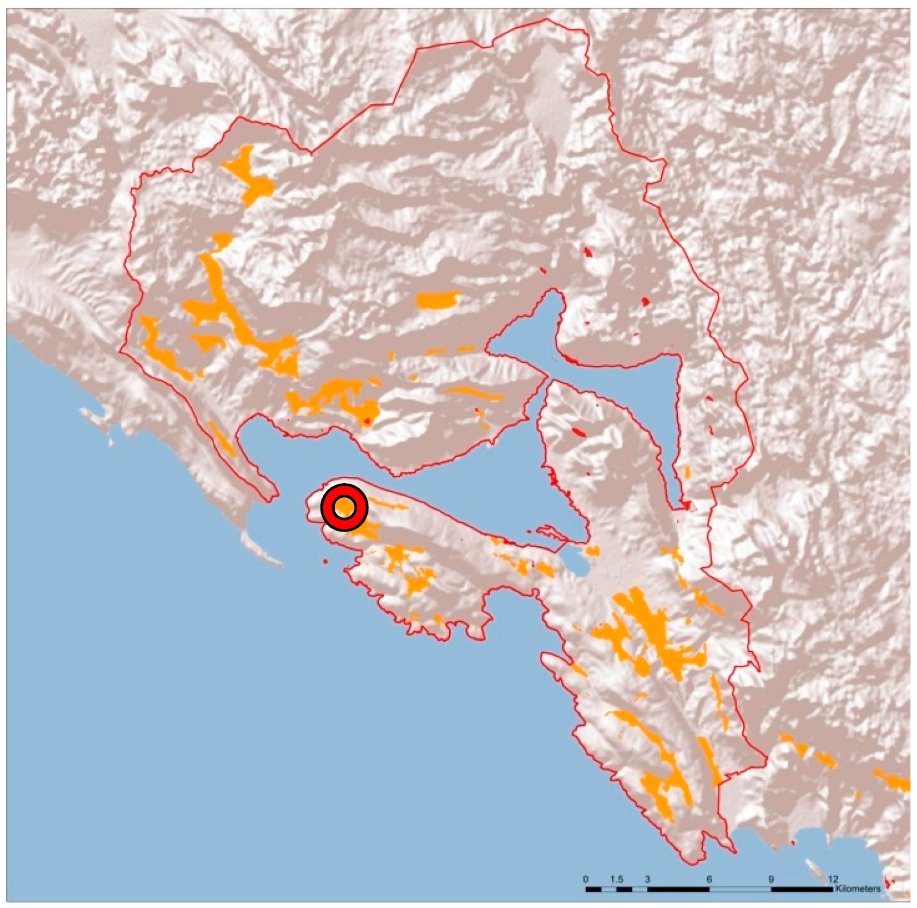
The rural settlements developed on sloped terrains in the hinterland of the Boka Kotorska Bay are of a terraced settlement type (
Figure 1). On the other hand, the settlements developed in plains have a completely different spatial pattern, consisting of fields bounded by hedgerows and borders. Particularly interesting are the old, mainly deserted settlements where the space is virtually abandoned.
Bigger or smaller parts of these settlements are characterized by the rich built heritage with the elements of traditional architecture and traditional terrain planning (retaining walls and borders), with still-present traces of different traditional crafts, the remains of old mills (for milling wheat or extracting olive oil), and the craft of stone masonry, as well as traditional plant species (olives, figs, grapes, and mulberry).
The presence of limestone and its use in construction has produced light-gray tones in the built forms. In the beginning, buildings were roughly shaped and constructed of ashlar stone, and later, they were constructed of rubble stone and ashlar stone. The stone that was used in construction was sourced from the region, as it was impossible to transport it from distant places.
In architectural terms, there are three main types of buildings in these settlements: residential buildings of traditional rural architecture, traditional buildings changed by contemporary building interventions, and modern buildings built in recent times.
2.2. Methodology
The proposed methodology of the planning approach to the revitalization of rural landscapes is partly based on the guidelines made by Ogrin [
19], containing recommendations for the sustainable management of Mediterranean landscapes in the future. According to Koreleski [
20], analysis of rural landscape creation (rural settlements are inseparable from the environment) should involve a multidisciplinary team of different experts, such as planners, architects, and experts in the fields of agriculture, forestry, biology, and ecology, and finally, lawyers, economists, and managers.
Landscape inventory and evaluation in relation to the natural and cultural value of space is an instrument which is recognized in both of the abovementioned methodologies as an important step in the process of rural settlement revitalization.
Value of a space refers to the relative values assigned to different landscapes. Landscape data such as soil type, land use, and topographic features could already explain a large part of the spatial variability of the landscape’s functions [
21]. In the context of nature protection, they are the basis for the identification of high-value landscapes. Landscape quality is based on the physical conditions of the landscape, namely its recognizability and naturalness, from the visual, functional, and environmental perspective. It reflects the state of individual features and landscape elements which make up its character.
The evaluation and mapping of landscape characteristics is commonly done by studies based on factors such as naturalness, relief, diversity of habitats, and historical distinctiveness [
22,
23,
24,
25,
26].
The following basic evaluation criteria were selected:
- →
Identity of natural and cultural elements of the landscape: evaluation of this criterion derived from the value of natural (forest areas) and cultural (terraced areas) landscape elements;
- →
Natural preservation: more valuable are areas with preserved natural elements; that is, where the space is perceived as native;
- →
Diversity: more valuable are areas with a greater diversity of elements; that is, a greater diversity of forms, occurrence of forests, disparity of relief, combinations of landscape patterns, and combinations of forests, relief, and water;
- →
Spatial order: more valuable are areas with a higher degree of spatial order or the presence of elements of spatial order, such as repetition, rhythm, direction, and gradation (for example, terraced regions with a distinctive repetitive pattern are evaluated as having a high degree of spatial order);
- →
Harmony (degree of adaptability to existing natural conditions, recognizability of landscape elements, and the like): harmony is marked as the most important criterion in evaluating the experiential value of the landscape and combining all previous criteria, especially diversity and spatial order: more valuable are the areas which are the result of a great degree of adaptation to the existing natural conditions.
The general model of vulnerability assessment takes into account the main landscape characteristics that might be put at risk in the case of construction in a given space (tourism, infrastructure, etc.), and referring to these features, the evaluation of landscape sensitivity, i.e., vulnerability, is provided [
18]. Traditional agriculture in the Adriatic area is organized using drystone wall and terraces. The remaining drystone walls and terraces represent the cultural heritage and a landscape element of great value. Unfortunately, the development of tourism and the construction of facilities in the surroundings have shown that the areas of greatest landscape value are the most vulnerable, and their neglect leads to their degradation or complete disappearance. Therefore, when evaluating areas with the highest landscape value, they are marked as the most vulnerable.
The observed landscape characteristics that may be potentially affected are as follows:
- -
Ecological characteristics—the environment (water, soil, air, flora, and fauna);
- -
Cultural characteristics—cultural heritage (e.g., traditional agricultural terraces with drystone walls);
- -
Landscape characteristics—the visual quality of the landscape.
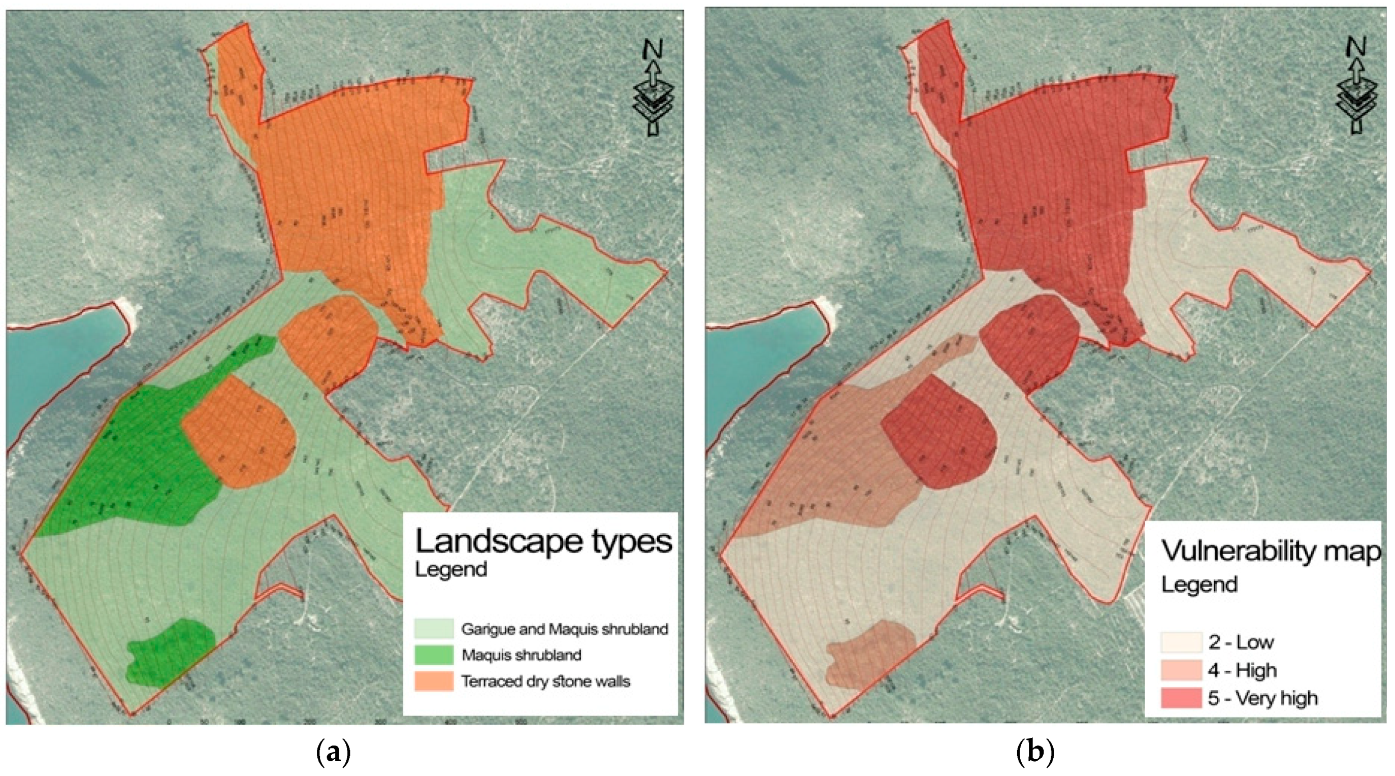
Vulnerability of a landscape can be seen as a particular form of space evaluation, which takes the view that more valuable landscapes are more vulnerable. The evaluation criteria are defined as numbers and descriptions (
Table 1), and they are graphically displayed by ascribing a grade to each identified landscape element.
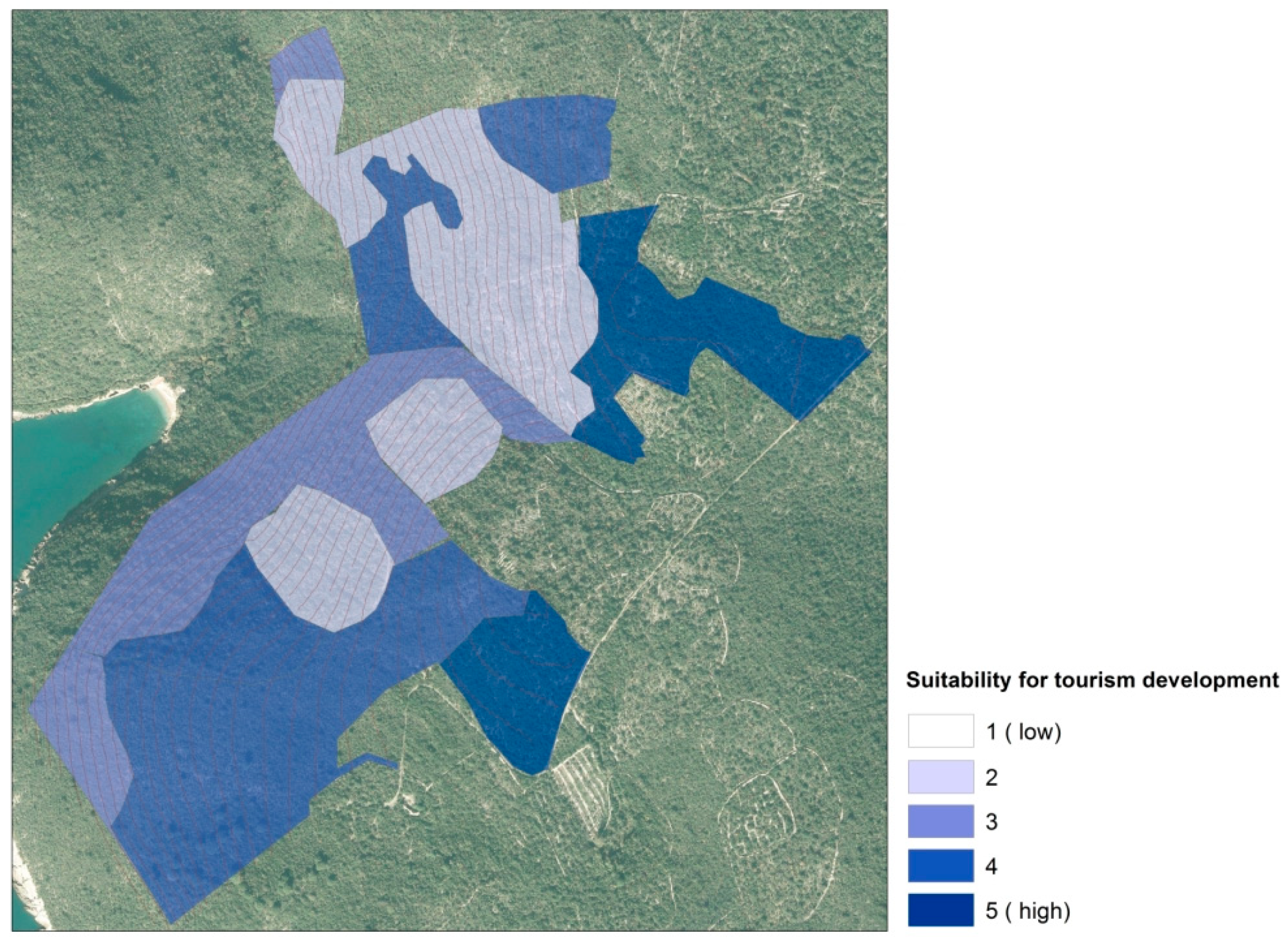
The zones suitable for tourism, which means construction of new buildings and supporting infrastructure, have been identified in a way that does not undermine natural value and cultural heritage, as well as the recognizability and main character of the landscape.
The orthophotographs, as background images, and software package ESRI ArcMap 10.1 (Environmental System research Institute (ESRI), Redlands, CA, USA) were used in determining the boundaries of the rural settlements and in the analysis of the spatial elements.
The overlapping of satellite images with thematic maps (geologic maps, soil maps, exposure maps, and slope and topographic maps) enabled a detailed analysis of typical traditional landscape elements in these settlements.
The analysis of the landscape at the site Mrkovi—Bijela Stijena in Luštica and evaluation of specific spatial units and risk assessment are shown on maps.
3. Results
3.1. Case Study—The Village of Mrkovi
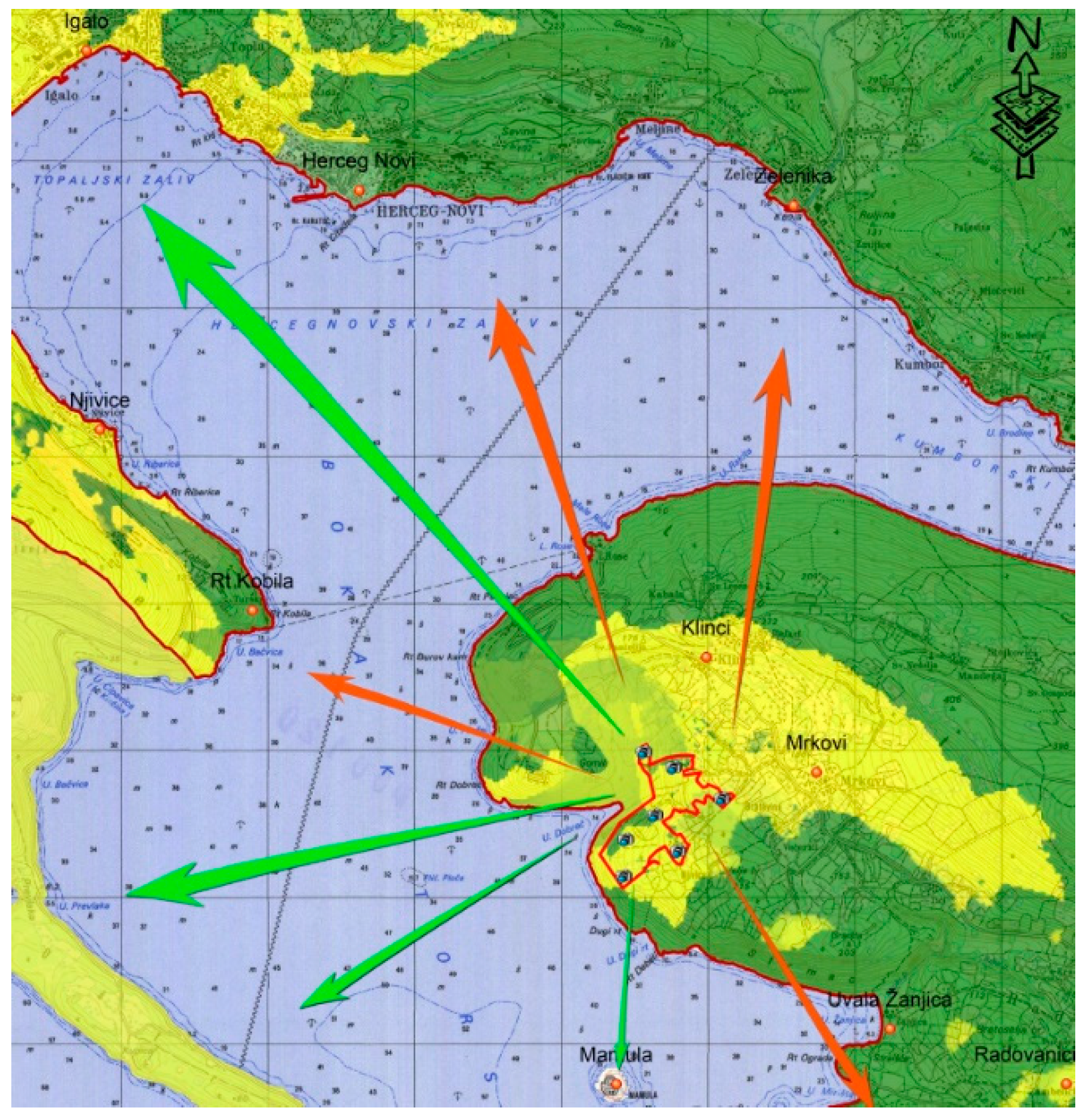
The village of Mrkovi is located on gently sloping terrain on the western side of the Luštica Peninsula. The immediate surrounding of the settlement contains dense maquis and distinguishing traditional terraces with the remains of olive groves. From this point, there are wide views of the open sea, Mamula Island, and the Prevlaka Peninsula. The location is accessed by partially reconstructed local roads. The Luštica Peninsula is an area with typical Mediterranean vegetation. The best preserved and most representative formations of hard-leaved Mediterranean vegetation specific to the Montenegrin coast can be found there. Specific and diverse natural value and valuable construction heritage permeate the entire area of the Luštica Peninsula, forming a unique and harmonious whole of seminatural, cultivated, and cultural landscape.
The analysis of geological and pedological characteristics as well the field studies have shown that the majority of villages in Luštica are located on poor skeletal terrain with shallow soil, so the terraces with olive groves represent the dominant spatial characteristic [
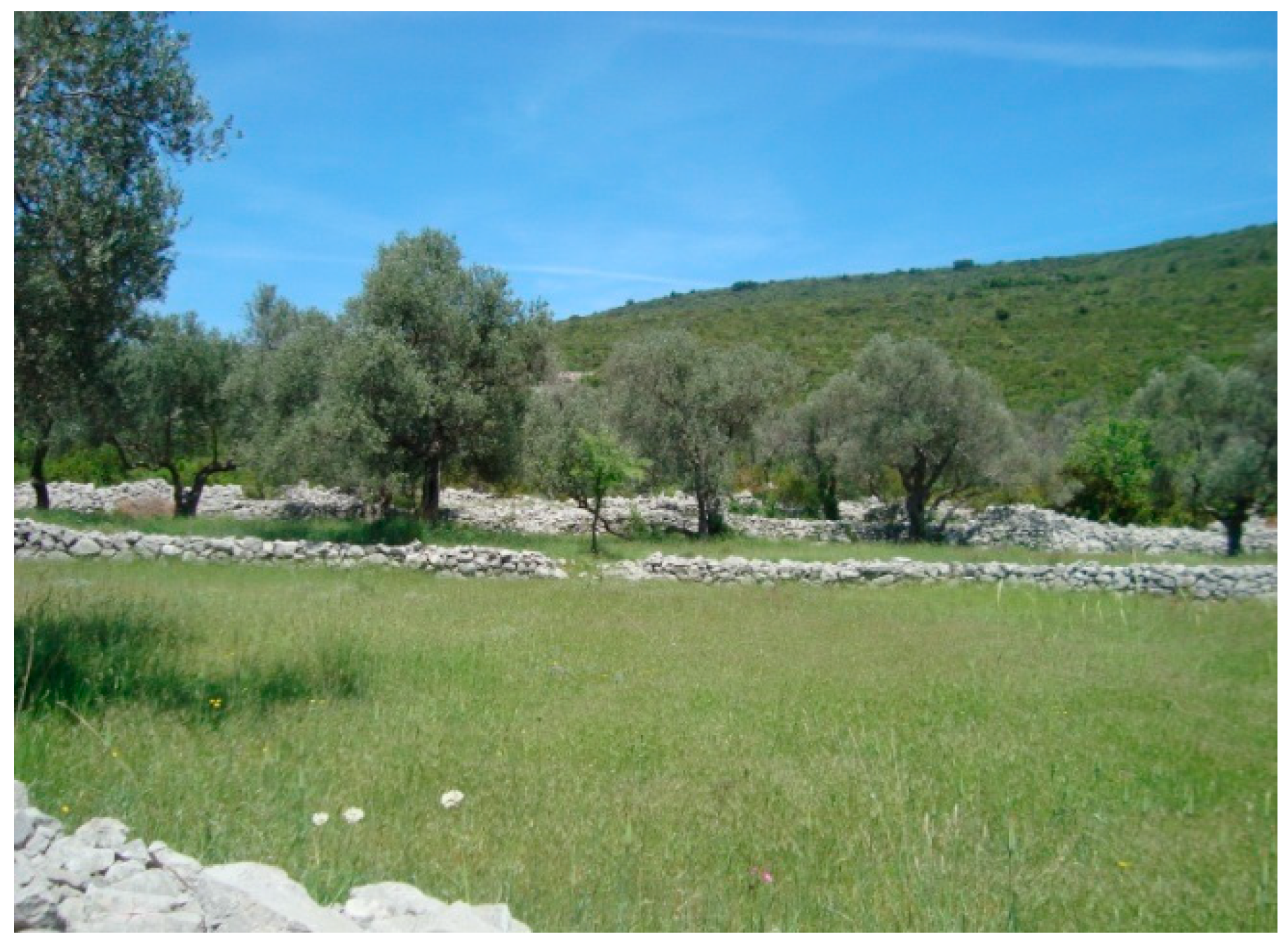
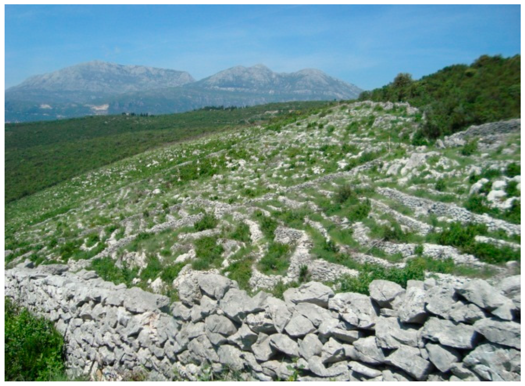
27]. Olive groves are bounded by drystone walls. Drystone walls are also dominant as supports to terraced terrains in which olives trees were planted, as olive growing used to be very extensive (
Figure 2 and
Figure 3). Today, most of these olive groves are abandoned and covered with bushy maquis.
Olive groves, along with other Mediterranean cultivated plants, produce a traditional mosaic structure typical of the Mediterranean region and representing the foundation for rural tourism. The terraces with the remains of ancient olive groves are divided by low retaining walls and fenced by stone borders. This landscape pattern is affected by lack of maintenance and it has been growing into maquis due to natural succession.
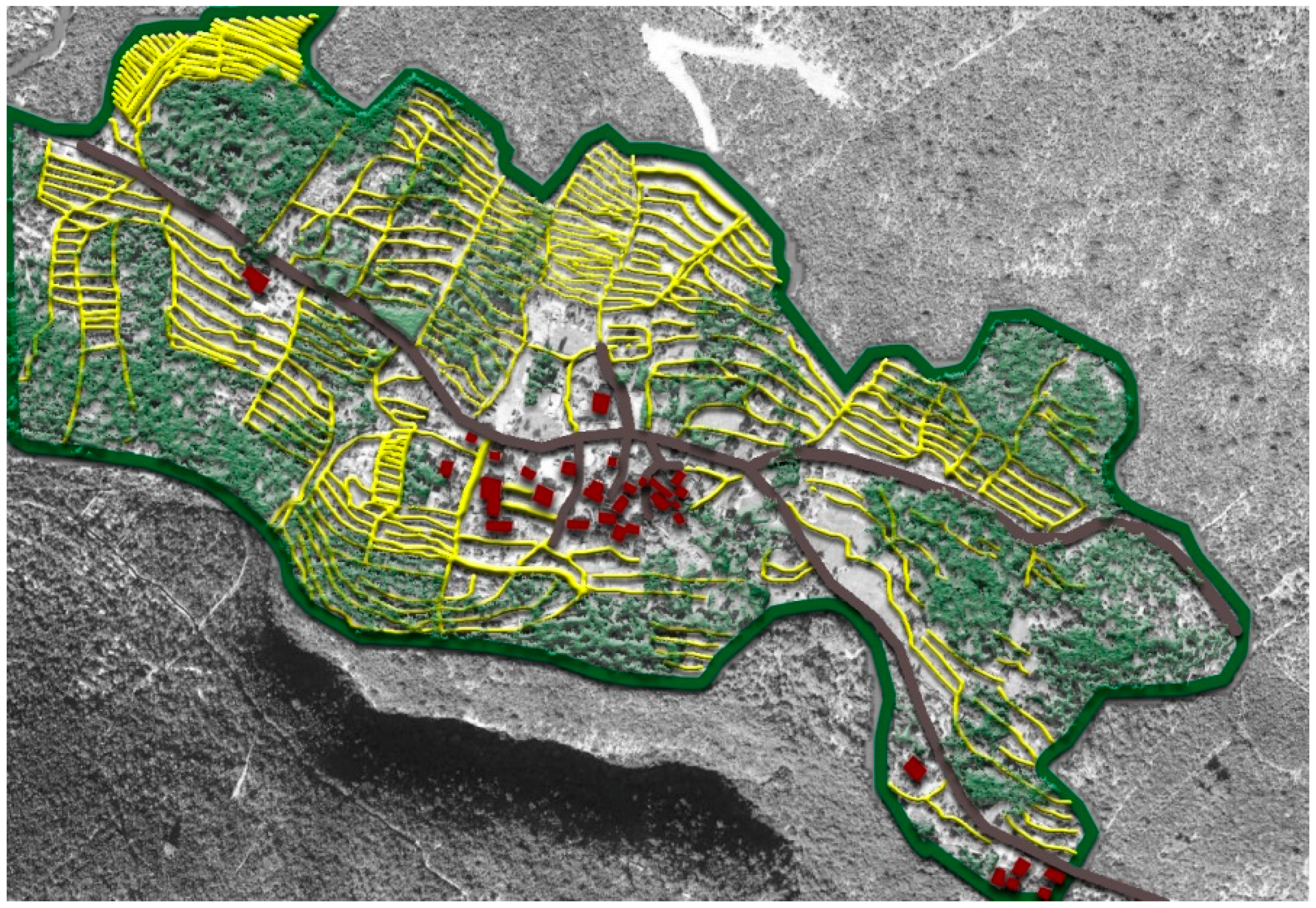
Typical landscape elements and landscape forms (
Figure 4) make this area distinctive, so the identification and evaluation of landscapes can be considered one of the most important steps in the rural settlement’s revitalization and development planning.
The studied area of the village of Mrkovi (
Figure 5) is located in the northwest part of the Luštica Peninsula and covers a part of the steep slope of the peninsula above the Dobreč Bay.
The landscape analysis and evaluation at the location Mrkovi—Bijela Stijena, where the construction of a tourist resort is planned, includes the spatial identification of the cultural pattern of traditional terraces with drystone walls (
Figure 4). The value of this type of landscape is reflected in the specificities of the traditional anthropogenic impacts in the Mediterranean area. This is also the most valuable and the most vulnerable landscape element in the studied area.
3.2. Topography
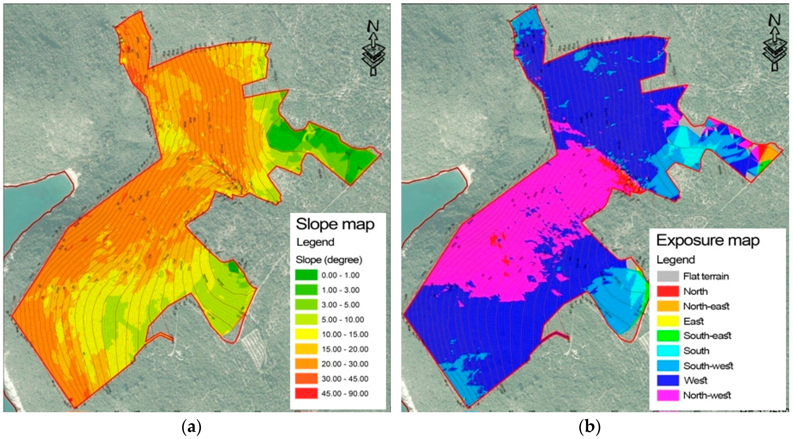
The analysis of terrain topography, inclination, and exposure (
Figure 6a,b) is important when selecting micro locations for both construction activities and agricultural activities.
As the terrain is jagged, the orientation of its individual parts is different: northwest, west, southwest, and south, with most of the terrain facing northwest.
The suitability of a certain site for developing vineyards, orchards, and olive groves depends on various factors. Areas with southern, southeastern, and western exposure are mostly used. While areas with higher inclination slope were used for vineyards by creating narrow terraces, for olive trees, cultivation used wide terraces on areas with shallower incline at lower altitude (
Figure 4).
3.3. Landscape Elements
The criteria for the selection of landscape elements basically have a common goal, namely to preserve the authenticity of the area with all its natural and cultural elements. Vulnerability of a landscape can be seen as a particular form of space evaluation which takes the view that more valuable landscapes are more vulnerable (
Figure 7a,b).
The guidelines of such an analysis indicate high risk from the activities planned in the space, i.e., construction of the tourist resort, which can be mitigated through compliance with the guidelines related to the rational use of the space and limiting the construction zones.
The preservation of the forest patches and valuable representatives of maquis is important for conservation of the biodiversity of the area and because of their erosion-protective function. Maquis has multiple kinds of significance: it prevents soil erosion, provides food and shelter for many animal species, and has aesthetic value giving a distinctive character to the Mediterranean landscape. Many plants are aromatic, and their specific smell spreads throughout the area in which they grow. Consequently, there is a growing tendency in most Mediterranean countries for the protection and preservation of maquis, despite the fact that this type of habitat is not on the official European list of protected habitats. The degree of sensitivity of maquis is conditioned by anthropogenic influences, while uncontrolled forest fires have become the most serious threat.
It should be taken into account that minimal interventions within valuable landscape elements could be useful for the protection of cultural forms and elements of cultural landscape as well as for the preservation of the terrain’s natural configuration. Restoring of agricultural production on the existing terraces by forming olive groves, planting citrus, lavender, and the like, and by linking such elements with tourist amenities may increase the value and attractiveness of the location, and at the same time, preserve the authenticity of the area. When planning construction at these locations, it is important to take into account the preservation of characteristic views (
Figure 5) from the location and of the location itself, depending on the nature and content of the contact zone.
3.4. Evaluation
By overlapping all the analyzed spatial data, clear guidelines are determined regarding the rational and sustainable spatial planning and the establishment of zones where various activities could be planned (construction of new buildings, agricultural activities, supporting infrastructure, etc.).
Since this is an area that should be valorized for the purposes of tourism, the zones for the needs of tourism (
Figure 8) have been identified, but in a way that does not undermine the natural value, cultural heritage, and recognizability and character of the landscape.
4. Discussion
4.1. Mediterranean Experience
The examples from some European countries show significantly increased awareness of the importance of cultural landscapes in preserving landscape diversity and spatial identity. The Tuscan landscape has become a symbol of the region and the Italian lifestyle all over the world [
28]. Many conventions and strategies oblige all signatory states to get involved and to find mechanisms to protect and spatially define these areas.
Rural cultural heritage at the international level is defined by various conventions, charters, and recommendations. The conventions signed and ratified by Montenegro constitute a framework used when developing national laws.
Rural development largely depends on a combination of specific regional and local factors, structures and trends, work ethics, regional identity, participation, and the attractiveness of the cultural and natural environment. All these factors are connected with the population and migration [
29].
The UNESCO World Heritage Convention, inter alia, states that “the cultural and natural heritage is among the priceless and irreplaceable assets, not only of each nation, but of humanity as a whole. The loss, through deterioration or disappearance, of any of these most prized assets constitutes an impoverishment of the heritage of all the peoples of the world”.
Most European countries (such as Italy, Spain, France, England, and Slovakia) already have inventories of cultural landscapes in the form of landscape atlases.
The whole Mediterranean region (including the Montenegrin coast) is known for the significant impact of agricultural activities, which has been recognized by numerous authors [
30,
31,
32,
33].
4.2. Revitalization of the Rural Settlements
Understanding local culture and spatial character can help us understand the “spirit of place” that must be the main inspiration for landscape designers [
16]. After defining the problems in the area which lead to the devastation of the landscape, and after setting the goals and vision of the development of the area, the value assessment and the human pressure analyses can be done. Performing the analysis of the attractiveness of various types of agricultural activity (viticulture, fruit growing, and olive growing), and then overlapping it with the areas which have been recognized as being valuable from the viewpoint of cultural and natural heritage gives a clear idea of conflicts in the space.
By addressing and minimizing the conflicts in the space, the optimal model of revitalization of the rural settlements is to be established. The final stage belongs to urban design and it is a very important stage in which specific attention is paid to the integration of existing and creation of new spatial structures [
19].
The principal task is to explore natural and cultural heritage (traditional architecture, customs, and authentic culinary products, etc.) to motivate people to actively engage in agriculture, thus enabling them to make profit from it [
34].
Looking at the variety of spatial elements (terraces, plots fenced with borders and drystone walls), Ogrin [
19] believes that, besides ancient cities, such cultural landscapes constitute the most valuable cultural heritage. Modernization of agriculture causes change in the spatial matrix, including land consolidation and formation of extremely large cultivated surfaces. In this way, vegetation is almost completely removed, often changing topography of the terrain, so it is very important to find an adequate ratio, i.e., the size of these spatial elements, in order to preserve the landscape character.
Development and protection of rural areas depends on the implementation of ameliorative measures and different activities in the fields of recultivation and soil improvement, antierosion measures, and improvement of forest areas through investment in the reconstruction of existing and construction of new facilities, town and village centres, road construction, water supply, and so on.
Rural heritage is a specific category which is related to the aspect of cultural heritage, but it is inseparable from rural development, spatial planning and urban design, nature protection, tourism, and landscape/scenery protection, and due to these relations, there are several laws and strategies indirectly related to the matter. However, the decisions of local governments and residents, who perceive economic and technological growth as the synonym for development, are often accompanied by ecological imbalance or cultural heritage degradation and are always followed by visual changes [
35].
In the context of various studies that indirectly deal with rural heritage, the example of Italy has to be mentioned [
36]. Over the last few years, Italian sustainable rural development policy has been focused on the fact that the historical connection between man and nature generates the cultural, social, and economic value of a space. Several European programs and projects dealing with agricultural heritage, as well as the experience of European rural policy, point to the importance of identifying cultural values in correlation with landscape value. On the other hand, environmental policy in Italy has had a negative impact on rural development through some strategies, implying that agricultural production destabilizes natural ecosystems.
Contemporary development strategies are increasingly recognizing the importance of rural areas, not only because of the tendency toward more balanced development, but because rural areas are viewed as areas of survival, and therefore these strategies include various revitalization action plans for their revival [
37].
4.3. Traditional Farming on Terraced Areas
Traditional farming on terraced areas is typical for slightly inclined surfaces. By cascade levelling and building stone retaining walls, soil characteristics were improved, especially soil depth and humidity. These spaces are specific to the formation of olive groves and other terraced crops. Drystone walls are an important landscape element which give it a particular attractiveness and recognizability.
The drystone walls, with their shape, surface, appearance, and purpose, are among the most representative examples of autochthonous architecture.
The skill of building drystone walls and similar structures has been part of the traditional heritage of the Mediterranean area since prehistoric times. It can be said that drystone construction represents a basic element of the cultural landscape of the Montenegrin coast.
The stone from that location was used for the construction of drystone borders. This wall was built around the fields, showing the boundaries of the property, limiting the passage, or preventing animals from straying. Due to the lack of trees in the vast rocky terrain, drystone walls were once the only shelter from hot summer temperatures.
In former times, as well as today, the drystone walls had many functions: as an element of farmland fencing, as an element of pasture fencing, and as a supporting element in the form of a terrace [
30]. Among the most evident landscape signatures of the human fingerprint, the terraces related to agricultural activities are of great importance. This technique is widely used in various parts of the world under various environmental conditions [
38].
In all Mediterranean basins, terraced landscapes are considered to be among the most important and characteristic anthropological imprints on the relief and they symbolize an important part of European cultural heritage [
39,
40]. Terraces, which are a characteristic Mediterranean landscape element, occur in all landscape types, but they vary in terms of density, purpose, and current function [
41]. Due to their structural characteristics, terraces can be divided into several types: narrow, medium, and wide, depending on the inclination, geomorphology, and type of soil.
In the hinterland of the Bay of Kotor, this landscape element occurs almost always properly following the direction of the contour lines. The areas with olive groves can be seen as a special form of cultural landscape created by human activities, and as such, is an important element of the space. Typical terraces with olive groves are mainly located on layered and plate limestone terrain and partly on flysch and delluvium. There was no family, not even the poorest one, that did not have an olive tree planted on its land.
4.4. Luštica Peninsula
The residents of the Bay of Kotor have been olive growers for centuries, and the evidence for this is century-old olive trees planted along the Bay of Kotor coast, especially on the Luštica Peninsula, where every house had its own mill. These mills are preserved and operational, but not used.
On the Luštica Peninsula, where olives have always been grown, some of the olive trees are hundreds of years old, and some even three centuries old. Between the olive trees, bushes of lavender, sage, and rosemary can be found, and the olive grove, particularly in spring and summer, with its countless shades of green and smell affecting all the senses, looks like an unreal place from a fairy tale.
Luštica Peninsula has always taken a lead in number of mills. From the oldest types powered by men or harnessed animals, only some remains can be found, because they are completely torn down or the ruins without roof and walls are covered with tall trees and shrubs so that they are difficult to access. Often, one can find oil saw and grinding wheels as evidence that once mills existed in those places.
The landscape of Luštica is distinctive and recognizable as a cultural landscape, and therefore interventions in space must be carried out very carefully with a tendency to integrate and preserve valuable elements of the existing landscape.
4.5. Landscape and Development
Development of rural areas cannot be considered only in relation to economic and monetary values, as it inevitably relies on the evaluation of the landscape, which must be taken into account when planning the development of these areas. Rural areas, for example, could be transformed so as to continue to organize their existence on the basis of the new bio-economy and new agricultural activities based on the preservation and sustainable capitalization of natural resources and cultural heritage. The primary function of spatial models is to search for alternative solutions and to assist land use planning [
42,
43,
44]. Evaluation of landscape value using GIS tools and different thematic layers should be a fundamental part of developing landscape protection plans [
45,
46,
47].
If we take into account that this area is suitable for the development of organic agricultural production, and given the low environmental impact of the existing agriculture, development of this area can be seen to link rural tourism and agriculture with the objectives related to sustainable agricultural development, reduction of chemical and physical degradation of agricultural land, and the conservation of the biodiversity of agricultural ecosystems. There is a tendency that, in perspective, people will ‘choose’ to settle in rural areas and they will not be ‘forced’ to stay, since they have no other choice in life [
48].
5. Conclusions
The principles of the preservation of cultural heritage indicate the need for the integrated protection of natural and cultural heritage. Traditional cultural elements of rural settlements should be viewed through the analysis of the architectural and agricultural heritage in rural areas that is in synergy with the surrounding natural environment.
In the process of rural revitalization and development, efforts should be made to ensure landscape recognizability, taking as a basis the existing quality and characteristics of the space and the relationship of cultural and natural heritage. The research recognized the importance of identifying and evaluating the landscape elements in spatial and building planning for future evaluation of the settlement as being important measures for preservation of the space’s identity and quality.
Preserving the architectural identity with the planned development and renewal of settlements is implemented through landscape preservation. Dimensions and materialization of new facilities should be adapted to the existing, inherited structures.
Agricultural production should be organized in accordance with the landscape characteristics with an emphasis on raising the value of local products, the use of traditional skills, and the like.
The modern infrastructure standard should be provided throughout the entire rural area, and tourism should be introduced in a very subtle way, adjusted to the needs of people in modern society, but also to the rural environment. This would ensure the preservation of the spirit and quality of the landscape that should remain the main engine of growth.
