Can We Really Have It All?—Designing Multifunctionality with Sustainable Urban Drainage System Elements


1
Department of Architecture, School of Arts, Design and Architecture, Aalto University, 00076 Espoo, Finland
2
Department of Built Environment, School of Engineering, Aalto University, 00076 Espoo, Finland
*
Author to whom correspondence should be addressed.
Sustainability 2019, 11(7), 1854; https://doi.org/10.3390/su11071854
Submission received: 10 February 2019
/
Revised: 13 March 2019
/
Accepted: 21 March 2019
/
Published: 28 March 2019
(This article belongs to the Special Issue Green Stormwater Infrastructure for Sustainable Urban and Rural Development)
Abstract
:Multifunctionality is seen as one of the key benefits delivered by sustainable urban drainage systems (SUDS). It has been promoted by both scientific research and practical guidelines. However, interrelations between different benefits are vaguely defined, thus highlighting a lack of knowledge on ways they could be promoted in the actual design process. In this research, multifunctionality has been studied with the help of scenario analysis. Three stormwater scenarios involving different range of SUDS elements have been designed for the case area of Kirstinpuisto in the city of Turku, Finland. Thereafter, the alternative design scenarios have been assessed with four criteria related to multifunctionality (water quantity, water quality, amenity, and biodiversity). The results showed that multifunctionality could be analyzed in the design phase itself, and thus provided knowingly. However, assessing amenity and biodiversity values is more complex and in addition, we still lack proper methods. As the four criteria have mutual interconnections, multifunctionality should be considered during the landscape architectural design, or else we could likely lose some benefits related to multifunctionality. This reinforces emerging understanding that an interdisciplinary approach is needed to combine ecological comprehension together with the system thinking into SUDS design, locating them not as individual elements or as a part of the treatment train, but in connection with wider social ecological framework of urban landscape.
1. Introduction
During the last decade, with the emergence of the concept of green infrastructure (GI) and its recognition as a network of natural and semi-natural areas delivering multiple benefits [1] into urban landscape planning, multifunctionality has subsequently crystallized as a defining criterion for ascertaining the quality of this urban landscape [2,3,4,5,6]. As it has become desirable for the capacity of the urban landscape to expand to provide multiple benefits, multifunctionality has emerged as an aspect of great importance. This has been further enhanced by the compact city ideology promoted by agencies, such as the UN’s New Urban Agenda [7]. Indeed, this compact city structure reduces opportunities for urban greenspaces and inevitably requires them to be multifunctional [8].
As the GI approach becomes adopted, there is an on-going and simultaneous transformation towards water sensitive urban design (WSUD), due to climate adaptation and water quality issues [9]. WSUD offers an alternative to sewer based urban drainage systems and covers a series of ecosystem service based approaches to urban stormwater management. Furthermore, it encourages the use of above-ground solutions, such as rain gardens, swales, green roofs, and wetlands (i.e., technologies called sustainable urban drainage systems (SUDS)); in fact, the delivery of multiple benefits is an essential part of the approach [10]. The role of SUDS is to harvest, infiltrate, slow, store, convey, and treat runoff on site [11] to sustain the existing local hydrology.
In addition, along with direct water-related benefits, SUDS possess the potential to create synergies with other functions in urban areas. An increased amount of vegetation combined with visible water provides several ecosystem services, such as habitat provision, erosion control, microclimate regulation, recreation, and aesthetical experiences [12,13]. However, there is no precise understanding of the ways multifunctionality and a combination of benefits can be promoted with SUDS in an urban landscape, due to related research concentrating mainly on the evaluation of individual benefits [14,15]. Moreover, studies that simultaneously touch on hydrological and ecological benefits do not consider the design process, but mainly evaluate existing structures [10,15].
This paper examines opportunities to design multifunctional urban greenspaces by integrating SUDS elements into the urban landscape. The aims are to shed light on the preconditions required for the provision of different SUDS related benefits, and further discuss the ways they can be addressed in the landscape architectural design of urban greenspaces. This paper answers the question of how the multifunctionality of SUDS can be estimated during the landscape architectural design process. The results are discussed to additionally understand the relations between different criteria of multifunctional SUDS, as well as ways of consequently incorporating this understanding during the design phase.
A scenario analysis is the method chosen with the research being conducted in three phases. First, three scenarios have been created representing three different strategies of stormwater management: (1) substituting part of the pipe network with open swales, (2) adding SUDS elements that allow water detention, and (3) maximizing the amount of SUDS elements on the site. This is based on an approach that combines SUDS elements into differing treatment trains allowing the formation of a portfolio of options, which contribute to a variety of benefits [16]. The scenarios have been designed based on a case study area of the site of Kirstinpuisto in Turku, Finland; each of them is composed of a varying combination of SUDS elements to create three different treatment trains.
In the second phase, methods to measure the potentially provided benefits (stormwater quantity and quality management, amenity, and biodiversity) are studied and tested with the three scenarios. Finally, possible synergies or conflicts among different benefits are scrutinized and discussed, including the potential of the landscape architectural design process to provide multifunctional greenspaces through stormwater management.
2. Multifunctional SUDS
Multifunctionality is defined as “an integration and interaction between functions” [17] (p. 655) or as an ability of GI to “perform several functions and provide several benefits on the same spatial area” [3]. Multifunctionality is also described as the capacity of GI to provide multiple ecosystem services (ESS) [18]. In the ESS approach, benefits are commonly divided further into provisioning, regulating, and cultural ecosystem services, according to the Common International Classification for Ecosystem Services, with the understanding being that by simultaneously providing these, it could help achieve several environmental, social, and economic urban policy aims [19].
The ESS approach is closely linked to the cascade model of ecosystem services [20] stating that without correct biological structures, processes, and functions, the provision of ecosystem services is incomplete. Furthermore, the provision of services leads to human well-being and valuation of the provided services (e.g., monetary value). Hansen and Pauleit [4] have underlined that in GI approaches, the term “functions” can be confusingly used to mean the same as “services,” whereas in the ESS concept, “functions” are understood as an intermediary step of the biophysical structures and processes needed to provide ESS. In this paper, “functions” and “services” are understood in line with the ESS cascade model, highlighting our dependency on well-functioning urban green elements. Such elements should be planned, designed, and managed in a way that is “sensitive to, and includes provision for, natural features and systems” [3].
Although multifunctionality is regarded as being essential and its connection to biological structures and functions is commonly recognized, the conflicts or synergies between different benefits have not been adequately studied. Meerow and Newell [21] have argued that most green infrastructure related research and planning focus only on a handful of benefits, despite a major demand for the use of GI to mediate between different and potentially conflicting demands [19]. If multifunctionality is seen as the main feature of GI, which delivers solutions to urban environmental challenges and maintains the quality of life [6], it is essential that research is the framework through which we understand the potential synergies or conflicts among its assigned benefits as well as the limitations of providing them through landscape architectural design.
More specifically, urban planning and design outline facilities for urban multifunctionality. In the context of a green infrastructure, it means the integration of systems supporting vegetation growth, such as water, vegetation, or carbon cycles. However, the operationalization of multifunctionality in planning [4,22] and practical examples are still lacking in GI planning and design.
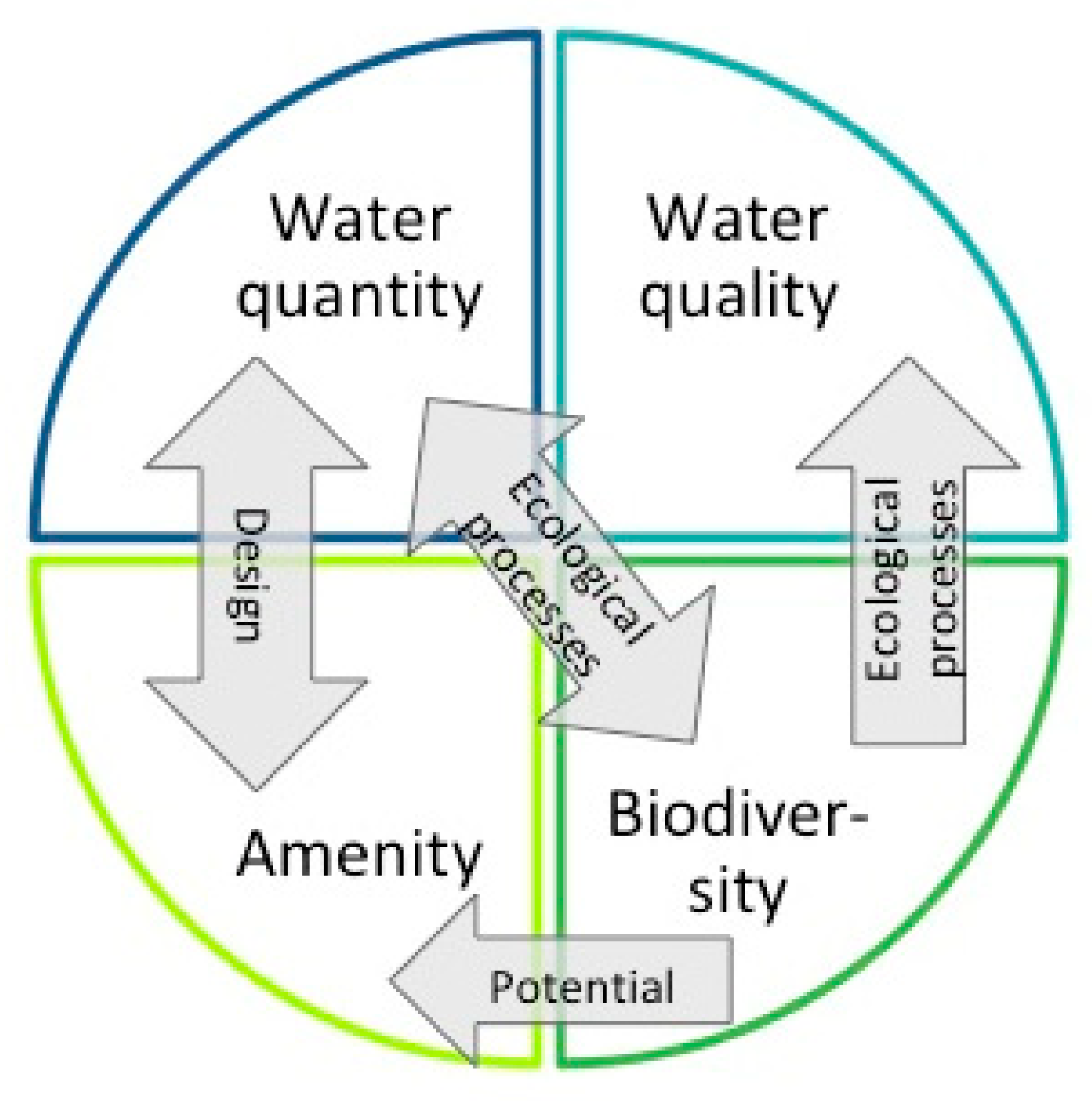
CIRIA, a well-known and respected British forum for water sector industry improvement, has defined the multifunctionality of SUDS. In its guidelines [11], CIRIA has provided four criteria for the design of SUDS—water quantity, water quality, amenity, and biodiversity (Figure 1). Despite these guidelines, the design, implementation, and maintenance of SUDS often emphasize drainage functions over its additional benefits [16,23]. Moreover, when measuring SUDS multifunctionality, a mostly natural sciences approach has been utilized to explore and enumerate the provision of quantity and quality management; in addition, amenity and biodiversity provision have been less well researched [12,14,15,24]. Thus, the authentication of multifunctionality with SUDS in landscape architectural design of urban greenspaces still lacks precise indicators. In this study, the design criteria provided by the aforementioned C753 SUDS Manual [11] are utilized as a framework to define the multifunctionality of SUDS solutions.
SUDS are inherently multifunctional structures if the criteria are considered sufficiently early on and are fully integrated into the urban design [11]. In the following section, each of the criteria is shortly introduced together with an understanding of the ways they can be promoted through design. Additionally, the four criteria provided by SUDS are not independent of each other [14,15,25]; thus, mutual interconnections are also clarified.
Being part of the drainage network, the primary function of SUDS is to control water quantity [13] to prevent both flooding on-site and in downstream areas. Additionally, on-site water quantity management helps to preserve the natural hydrological functions of a catchment. We are aware that different SUDS elements possess a varying effectiveness to perform run-off regulation [26]; for example, bioretention cells infiltrate water and slow down surface flow together with vegetation that additionally intercepts and evaporates water [27]. In the design process, varying SUDS elements can be chosen and combined depending on the qualities of the site; for example, if there is an abundance of space available, aboveground elements can be used, but if the urban structure is very dense, green roofs might be needed. Furthermore, both the location in the watershed and runoff coefficient affect the amount of stormwater, which then specify dimensioning of elements and choice of vegetation.
On-site water quality management safeguards water quality in the receiving surface waters and ground waters. This impacts the living conditions of a variety of water-related flora and fauna as well as the wellbeing of local residents. The overall impact of a site on water quality is dependent on types of pollutants, the peak flow pollutant concentrations, and the total pollutant load in the runoff [11].
SUDS elements provide water quality improvements by reducing sediment and contaminants from runoff either through settlement or biological breakdown of pollutants. Multiple plant-related mechanisms, such as phytoextraction and phytodegradation [27], are important for biological treatment and pollutant removal. Again, different SUDS have different impacts; i.e., bioretention cells are effective in filtration, sedimentation, adsorption, and plant uptake [28], while extensive green roofs have a varying ability to retain pollutants depending on the season, substrate type, event size, and rainfall regime [29,30]. If the functions of different SUDS are known, it is possible to match the right SUDS elements to meet local stormwater quality management needs in the design process.
Amenity is related to the attractiveness of the site and the provision of recreation and leisure services [12]. Echols and Pennypacker [31] have listed amenity goals as being education, recreation, safety, public relations, and aesthetics. Furthermore, visible water and SUDS increase the amenity of urban green areas [32]. The amenity values experienced in existing urban greenspaces can be measured by scoring systems [13] or by investigating public perception (i.e., with questionnaires, such as those conducted by Bastien et al. [33]). During the design process, amenity values are challenging to measure, but opportunities for recreation, education, and human contact with nature, can be maximized by enhancing ease of public access and social interaction.
In addition, increased biodiversity affects perceived amenity in positive ways [12,34]; hence, SUDS with vegetation potentially adds amenity values. These values are increased by using above-ground SUDS and linking stormwater management to other functions in urban landscape [32]. Thus, already in the design phase, the proximity of SUDS elements to other structures, such as pathways, urban squares, and residential buildings allowing interplay with water, can actualize amenity values.
Biodiversity supports human wellbeing in various direct and indirect ways as biophysical structures, including functions related to biodiversity, are essential for ecosystem service provision [35]. Urban biodiversity relies on urban greenspaces in which human activities affect ecological processes [36]. In urban conditions, the land use changes, and the transformation of technical and social infrastructures as well as management practices can cause a loss of biodiversity [37].
Furthermore, biodiversity is based on ecological processes including decomposition, nutrient cycling, and fluxes of nutrients and energy [38], in which the hydrological cycle and water availability are essential features. Thus, SUDS contribute positively to local biodiversity [14,39], but for vegetation, it is a risk to consider SUDS only as a part of urban drainage systems. SUDS with vegetation, as with any biophysical structure, require physical inputs of nutrients and water to provide ecological functions [16]. Habitat heterogeneity, biomass production, and biodiversity benefit from the storing and infiltration of rainwater into the soil, instead of turning it into surface flow [15,38,40,41].
Similar to amenity values, there are ways of measuring the biodiversity of existing greenspaces [32,33,42]. In the landscape architectural design process, conditions for biodiversity are created through the vegetation and microbiology of soils; in this way, the implemented design later provides a platform for animal diversity. However, in the design phase, it is difficult to measure future level of biodiversity as it depends on factors, such as the level of maintenance and scale of ecological succession once the design has been realized [43]. Nevertheless, there are some factors that support development of local biodiversity and could be enhanced in design. Structural habitat heterogeneity that is created by abiotic and biotic components of SUDS solution is associated with a high degree of biological diversity, and can already be used as a proxy for biodiversity [39] in the design phase. Furthermore, biodiversity correlates with the size of the habitat, edge effect and connectivity of habitats [2,42]. When emphasizing the biodiversity aspect of SUDS elements, it is important to relate them to neighboring habitats and the larger ecological network.
3. Case Study and Methodology
This section introduces the case site of Kirstinpuisto and three stormwater management scenarios, as well as presents the methodology used to assess water quantity and quality by modeling. It is followed by the presentation and testing of two new assessment methods for amenity and biodiversity values. The results are shared in Section 4.
3.1. Kirstinpuisto Site and the Scenarios
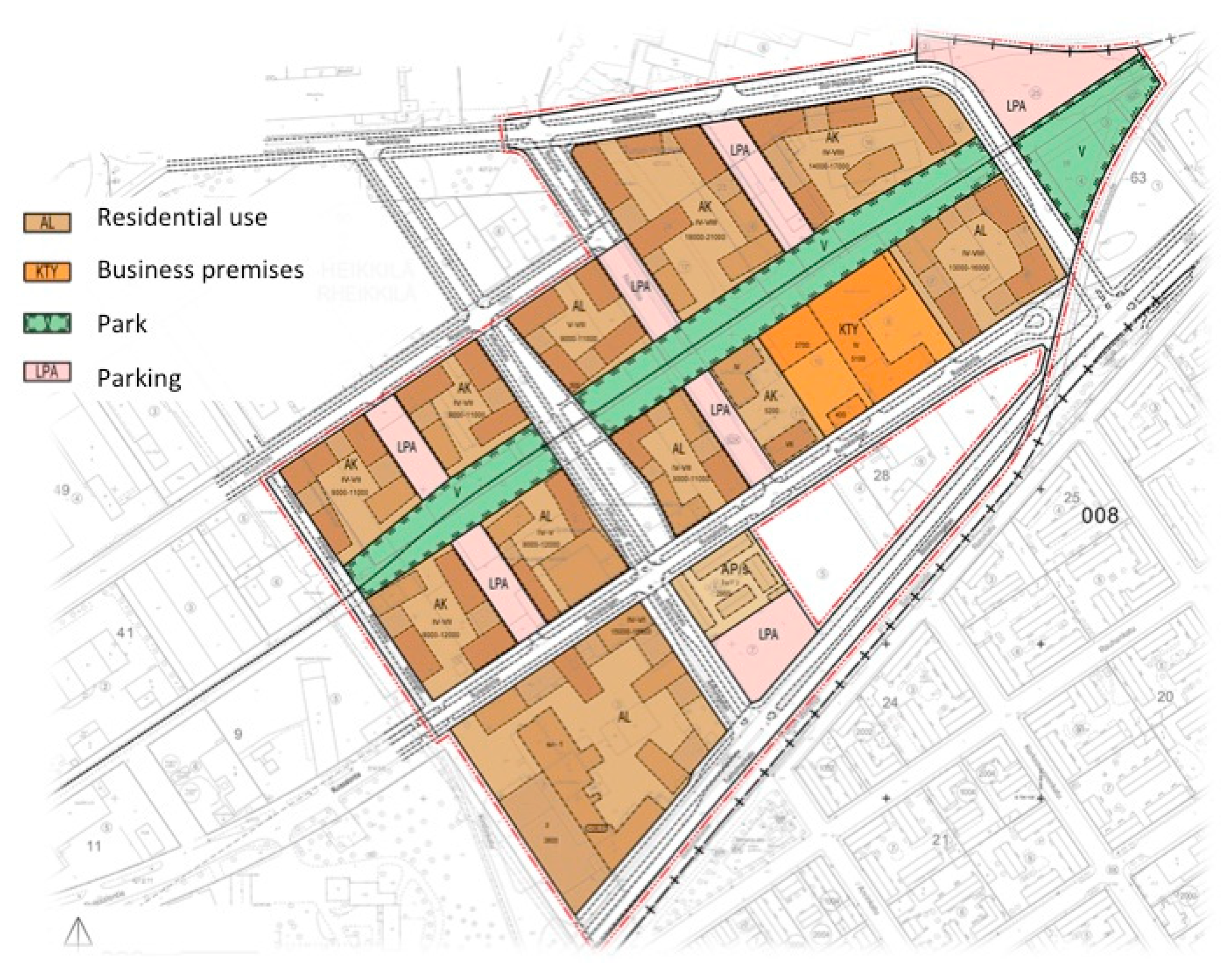
In order to assess the multifunctionality of different treatment trains combined from SUDS elements, three scenarios were created. Each of the scenarios includes a different composition of the SUDS elements, designed together in the context of the Kirstinpuisto site. The site is part of a large brownfield area close to the harbor of Turku that will be gradually transformed into a highly dense residential site. A detailed plan is underway (Figure 2).
The planning principles of Kirstinpuisto, 14 ha, are to create a lively neighborhood with good cycling and pedestrian connections to the city center. Most of the existing land uses will be transformed except for some land uses in the southern corner of the site. A thirty-five meters wide park forms the central axis through the site and four to six storied residential buildings will be built adjacent to the park. Traffic moves along two main streets, which intersect in the middle of the site. The main urban square is located by this intersection. On the streets, the pedestrian traffic is separated from the cars by green strips. The northwest corner of the site is left for parking and recreation.
The site has an existing drainage network, which will remain to be used in future, thus including it as part of the scenarios studied. The existing drainage network has had stormwater flooding issues in the past primarily due to the shortage of the existing drainage capacity. The aim of the scenarios is to create an alternative hybrid model utilizing the SUDS approach to substitute for the existing and malfunctioning drainage network.
The soil type on the site is clay, potentially rendering infiltration an ineffective stormwater management strategy; nevertheless, storing water would allow for some infiltration into the soil. The site is ideal for the study, because the general aim is to turn former brownfield sites from industrial use into residential areas; therefore, some new urban greenspaces need to be created in this conversion for residential use.
To increase the knowledge base concerning the green infrastructure solutions among local authorities as well as to gather understanding of local interest towards the site, an ESS workshop was held in August 2016 with city planners. The aim of the workshop was to familiarize participants with the concept of ESS and discern local demand. As a result of the workshop, five aspects rose to the fore: (1) the creation of a recreational and restorative living environment is important for future residents; (2) stormwater quality and quantity management are both essential on the site; (3) innovative green infrastructure solutions can help to create new identity to former brownfield area; (4) a diverse urban green will safeguard important regulating services, such as microclimate regulation, habitat provision, and pollution control; and (5) all previous goals can be achieved with a multifunctional and connected green structure. Based on these five points, three scenarios were designed to supplement the plan of Kirstinpuisto, which indicates the location of building masses and street network.
The scenarios have been designed to be realistic concerning the planned urban functions and Finnish building regulations. However, the space requirements and design of the SUDS elements have retained a rather simple and formal level for modeling purposes. The three scenarios (presented in Table 1, Table 2 and Table 3) have been entitled RUN (supplementing the existing pipe network on streets and in the central park with open swales), NORM (adding SUDS elements that allow water detention especially on residential yards), and MAX (maximizing the amount of SUDS elements everywhere—in the central park, residential yards, parking areas, and close to business premises).
Scenarios have been designed on top of each other, thus retaining the main features from the previous one(s). Available space and building regulations concerning features, such as emergency services access, have set the boundary conditions for the location and dimensioning of SUDS elements. Left over space outside SUDS elements is assumed to be asphalt or other hard surface expect in the park, in which it is assumed to be lawn with random singular trees. In order to estimate the fulfilment of the four criteria of multifunctionality in the scenarios, each of them were estimated in four different ways presented in the following sub-section.
3.2. Water Quantity and Quality Assessment through Modeling
This study models the current state and the three designed SUDS scenarios using the stormwater management model (SWMM) (EPA, Washington, DC, USA [44]) to assess the impact of SUDS on water quantity and quality. SWMM [44,45,46,47,48,49] is a widely used tool for single event and long-term simulations of different water balance components, such as surface runoff, flood volume, discharge, and losses in urban areas. Losses refer to water lost from the system in the form of evaporation and infiltration. The SWMM model was first parameterized for the case study area in its current state, with the model subsequently being calibrated against two rainfall-runoff events (SC1 and SC2) and validated against one rainfall-runoff event (SV1) measured on-site between October 2017 and January 2018 [50]. The performance of the SWMM model was evaluated using the Nash-Sutcliffe efficiency (NSE) [51]. The calibrated model was then applied to the three SUDS scenarios presented in Table 4 and Table 5 using SUDS parameters adopted from studies conducted in Finland [50].
The effects of SUDS scenarios on water quantity were studied for a seven-month period (E1) consisting of an extreme event during summer (E2) and an intense event after summer (E3). Rainfall data for E1, E2, and E3 are available from a station operated by the City of Turku (Table 4). The station is located about 5 km away from the case study area.
An adaptive neuro-fuzzy inference system (ANFIS) is a fuzzy inference system formulated with a learning algorithm [52]. Proposed by [53], ANFIS is based on the first-order Sugeno fuzzy model. In this study, the five water quality input variables (Table 5) were first clustered by the fuzzy c-means clustering algorithm to place them into different classes. The fuzzy c-means clustering allows a set of data to belong to one or two classes. ANFIS was utilized by defining the Sugeno reasoning and a number of rules to develop a prediction model for turbidity by using these classes. The Sugeno model utilizes “if then” rules to produce an output for each rule. ANFIS uses the input and output variables to construct a FIS whose membership function (generalized bell) parameters are tuned using a back propagation algorithm [52]. Thus, the FIS can learn from the training data (AT1). The measured four input variables and one output variable were used to train (AT1, Table 4) and test (AT2, Table 4) the ANFIS model. The ANFIS model consists of five blocks [52]:
- A rule base containing a number of if-then rules.
- A database which defines the membership function.
- A decision-making interface that operates the given rules.
- A fuzzification interface that converts the crisp inputs into “degree of match” with the linguistic values, such as high or low.
- A defuzzification interface that reconverts to a crisp output.
The input variables for the ANFIS model were the 10-minutely rainfall, discharge, temperature, and electrical conductivity with the output variable being turbidity measured continuously on-site from November 2017 to January 2018 by Luode Consulting (Table 5). The rainfall was measured with a Vaisala Rain gauge, discharge was measured with an acoustic StarFlow sensor, and water quality variables measured continuously with an YSI multiparameter sensor placed in the same manhole with the flow sensor. In addition, 16 grab samples from the study site and surrounding areas representing different land uses including forest, railway station, and brownfield areas were collected. From the samples turbidity, total suspended solids (TSS) and metals, chromium (Cr), copper (Cu), lead (Pb), zinc (Zn) were analyzed in the laboratory. The performance of the ANFIS model was evaluated using the coefficient of determination (R2) and the Nash–Sutcliffe efficiency (NSE). The rainfall data available for event AT1 was used to simulate the discharge output for the current and three SUDS scenarios with the calibrated SWMM model [50]. Subsequently, the trained and tested ANFIS model was used to predict turbidity for the three SUDS scenarios for event AT1.
The effects on water quantity are quantified as changes in peak flows, total flow, and flood volume in the three SUDS scenarios as compared to the current state for E1, E2, and E3 along with losses for E1. For the long-term period (E1), the empirical cumulative distribution of flow rate is analyzed. The simulated flow rate below 0.025 l/s is considered zero.
Similar to water quantity, the effect of SUDS on water quality has been assessed using the ANFIS model for the current state and for the three SUDS scenarios. This study used turbidity as a proxy indicator for water quality after establishing significant correlations between turbidity and total suspended solids (TSS) and concentrations of chromium (Cr) and copper (Cu). The linear regressions for the 16 grab samples are shown in Figure S2. Turbidity is a measure of water clarity and the extent to which the material (e.g., soil, pollution, metals, and solids) suspended in water decreases the passage of light through the water. Memon et al. [54] showed a high correlation between turbidity and suspended solids in the stormwater runoff specifically in a construction site. They suggest turbidity be used as a substitute for total suspended solids (TSS) due to the ease of continuous measurement as compared to laboratory measurement for TSS. Likewise, Nasrabadi et al. [55] used continuous turbidity as a proxy for evaluation of metal transport in river water after establishing meaningful correlation between turbidity and TSS.
3.3. Assessment of Amenity and Biodiversity Values
Amenity and biodiversity values are inherently different from water quantity and quality management as the former two are much more related to the surroundings of SUDS elements: functions, materials, and environment impact amenity and biodiversity values as described in Section 2. The amenity values are assessed based on their links with mental health benefits provided by urban green and blue structures. Green and blue structures affect mental health through various mechanisms [56,57]—viewing and observing green and blue areas yield a restorative impact, environmental health (clean air, less noise) affects residential health and opportunities to perform physical activities, and social interaction also impacts health.
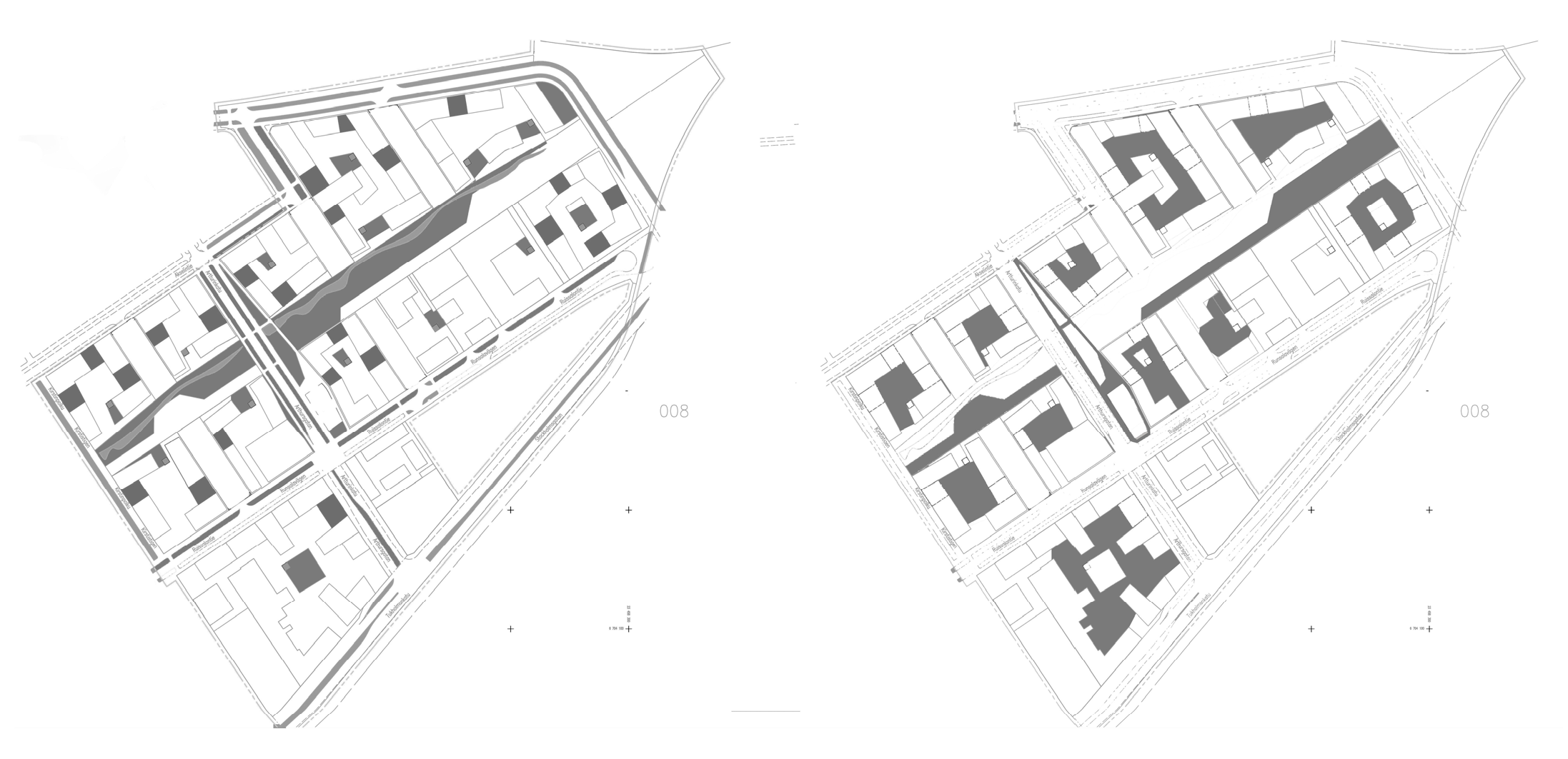
The provided health benefits of each scenario were assessed by applying two parameters (Figure 3). The first parameter involved measuring the total area of SUDS elements with vegetation easily visible from residential windows or from yards, streets, or other public spaces. Green roofs on top of one story buildings were included, but not from multistory houses. Permeable pavement was not counted, as there is no vegetation to observe.
The second parameter involved measuring the total area of surfaces in which people can perform activities or interact together close to SUDS elements with vegetation. Residential yards were included, if SUDS elements were present and in the immediate proximity of the user of the yard. The lawn areas allowing sports and leisure activities were included. The second parameter indicates the extent to which SUDS elements overwhelm other functions in yards or public open areas. If water management structures are too extensive, play areas, pathways, and squares enabling physical exercise and social interaction can be hard to fit in.
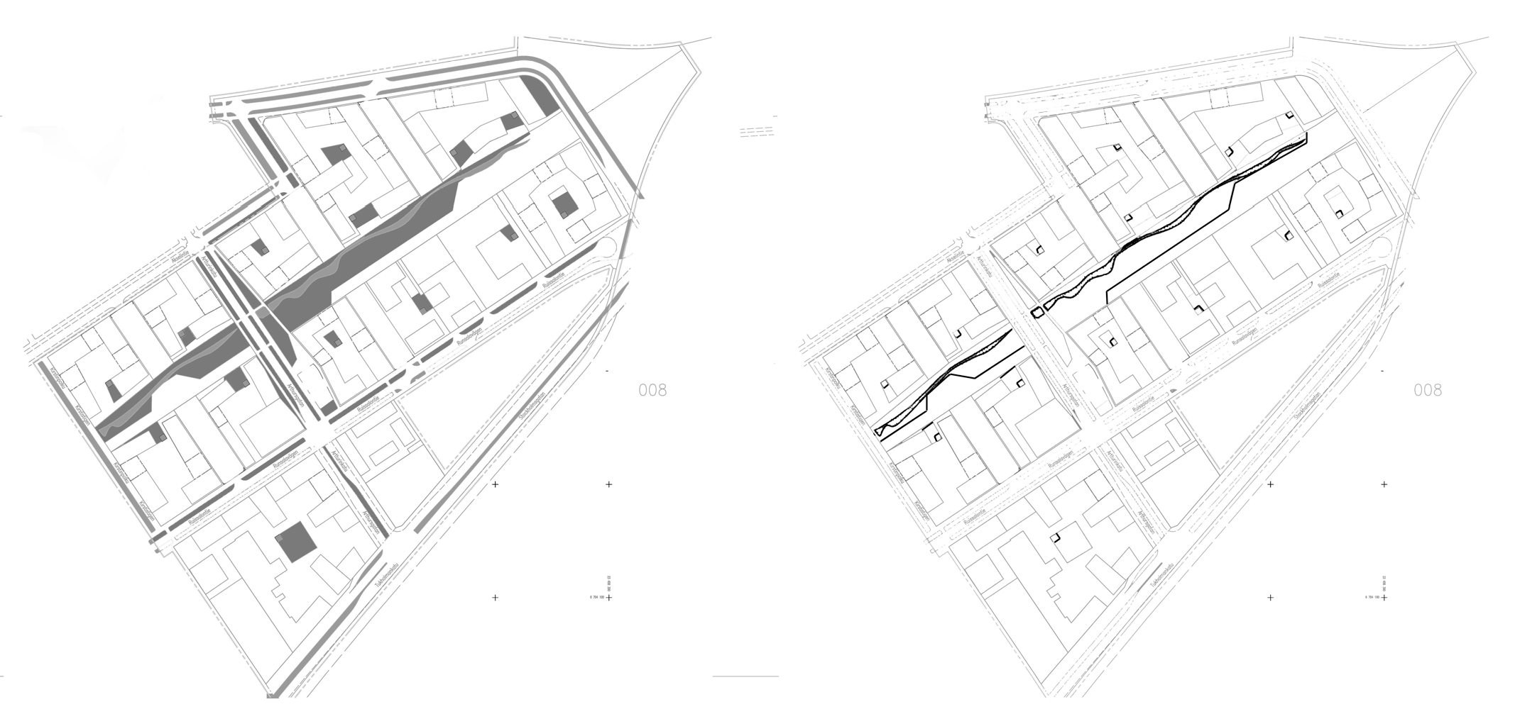
Similar to amenity, two parameters were utilized to assess biodiversity values of SUDS scenarios (Figure 4). The first parameter utilized the structural heterogeneity index score developed by Monberg et al. [39]. Their study developed an index score for different types of SUDS reflecting the structural heterogeneity potential to “assess potential ecological benefits of SUDS during the design phase”. The index scores are based on an expert analysis and reflect the capacity of SUDS elements to host abiotic and biotic components that increase structural heterogeneity. Thus, the same index scores are utilized in the study to evaluate the ability of treatment trains to enhance biodiversity by measuring their potential to enable structural heterogeneity. The approximate value for biodiversity is calculated by multiplying index scores with the surface area of each SUDS structure, thus reflecting the importance of size of habitat.
Monberg et al. [39] provided an index score for six different types of SUDS including swales (Index score 1.8) and rain gardens (Index score 1.0). The bioretention cell has been embraced as a dry basin (Index score 2.2), which is described to be “depressions…with straight edges designed to delay water and drain slowly until dry” [39] (p. 5). Green roofs were not included in Monberg’s study, and permeable pavements do not host any vegetation, thus, receiving an index score of 0.
The second parameter is derived from connectivity and edge effect as these factors also enhance biodiversity. The edge line of each SUDS element uniting with other vegetated surface (other SUDS element or lawn) was measured reflecting a connection to other green structures as well as the ability to create conditions for edge effect, that is, changes in species structure at the boundary of two habitats. Edge lines to non-vegetated surfaces were not measured, as they do not create ecological network connectivity.
4. Results
4.1. Water Quantity
The SWMM model for current state revealed a consistent performance in reproducing a measured discharge with the Nash–Sutcliffe efficiency of 0.69 and 0.82 for the calibration events (SC1 and SC2), and 0.86 for the validation event (SV1). Modeling showed that all scenarios had an impact on water quantity. Table 6 displays the changes in peak flows, total runoff and flood volumes for SUDS scenarios as compared to the current state for a seven-month period (E1), a short-extreme rain event (E2), and a short-intense rain event (E3). The RUN scenario is efficient at conveying stormwater aboveground in a vegetated channel in a controlled manner resulting in the reduction of 65–91% in flood volume. Thus, the RUN scenario is a good conveyance system, which also helped to reduce peak flows (18–24%) for all simulated events. However, for NORM and MAX scenarios, both peak flow and total flow volume of stormwater are reduced. The MAX scenario is the most efficient in reducing both peak flow rates and total volumes in the drainage network, even for the short-extreme event (E2). Furthermore, it produces negligible flooding for both simulated events.
For the seven-month period, E1, all SUDS scenarios showed a decrease in peak flow as well as a reduction in total and flood volumes as compared to the current state. The reduction of volume can be seen as an increase in losses, which comprise the total evaporation and infiltration. Losses are dominated by infiltration in NORM scenario and evaporation in MAX scenario (Table 6). For the short-extreme event, E2, the total runoff volume is reduced for all scenarios; this is mainly due to the temporary storage of stormwater in the SUDS as contribution by losses is negligible. The temporary storage provided by SUDS also helped reduce peak flow and volume for E2. The increase in the runoff volume in RUN scenario was due to the increased imperviousness from 63 to 80% from the current state. Despite the increased imperviousness due to the planned development, the RUN scenario still diminished the peak flows as a result of the stormwater retention and delayed conveyance in the vegetated channel. Thus, the SUDS in studied scenarios has helped manage water quantity on site through controlled conveyance in the RUN scenario as well as temporary storage and losses from the system in the NORM and MAX scenarios.
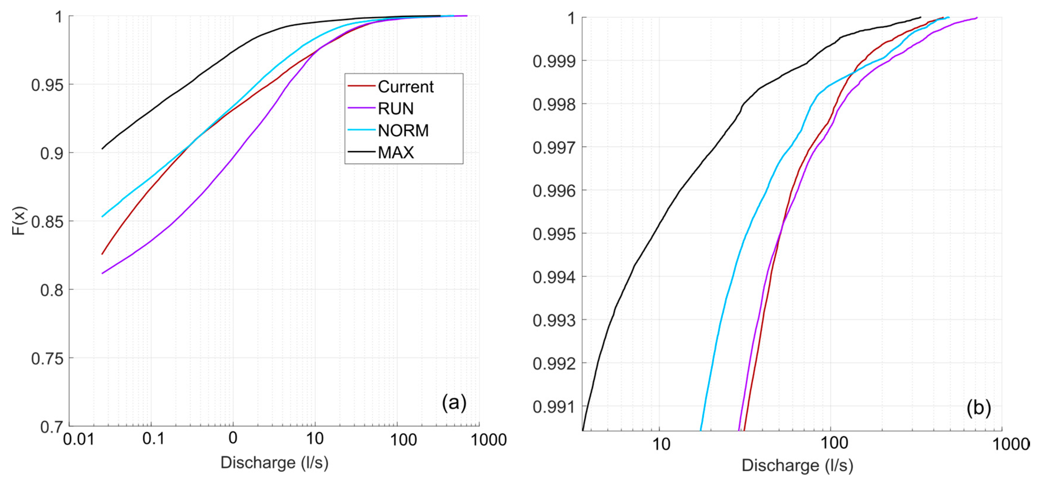
Figure 5 shows the cumulative distribution of SWMM model simulated flow rate for the current state and the three SUDS scenarios for the longer simulation (E1). From Figure 5a, it can be seen that the share of zero flows clearly increased for scenarios NORM and MAX, whereas only scenario MAX seems to be effective in decreasing high flow rates (Figure 5b).
4.2. Water Quality
The 95% confidence intervals of slope for TSS, Cr, and Cu excluded zero (Table 7), indicating that there is a significant relationship between turbidity and each of the TSS, Cr, and Cu.
The ability of SUDS scenarios to affect the flow volumes (Figure 5) indicates their ability to manage water quality on-site as turbidity reaches high values with high flow volumes. The trained ANFIS model has the coefficient of determination (R2) and the Nash–Sutcliffe efficiency (NSE) of 0.86 and 0.78, respectively. The statistics for the tested ANFIS model are 0.74 and 0.59 for R2 and NSE values, respectively. The comparison of measured and predicted turbidity for calibration and validation periods is shown in Figure S1.
The results show that the model performed consistently for both calibration and validation datasets. The correlation between turbidity and total suspended solids is 0.89. The correlation between turbidity and concentration of chromium and copper is 0.95 and 0.83, respectively (Figure S2). The MAX scenario is able to reduce 46.5% of the mean value of turbidity with a corresponding reduction in mean concentrations of TSS and metals of 7–73% when compared to the current state of the catchment. The corresponding reduction in mean value of turbidity for the NORM scenario is 11.6%. The reduction in water quality indicators is the highest for MAX followed by NORM. However, for RUN scenario, the turbidity value increased by 1.6%, and the concentrations of TSS, Cr, and Cu increased by 0.2–2.6% (Table 7). This is likely to be a result of increased imperviousness leading to larger flow volumes, and the positive relationship between flow volume and turbidity identified in the ANFIS water quality model.
4.3. Amenity
Amenity values consist of two parameters: the surface area of visible SUDS elements and the surface area of active spaces close to SUDS elements. For each scenario, both parameters are presented in Table 8 together with the total score. The MAX scenario delivers the highest amenity value through visible green and blue structures, but the other scenarios deliver more opportunities for physical activity and social interactions close to SUDS elements. Thus, the NORM scenario promises to deliver the highest amenity values as it contains both abundant visual interest and space for active interaction with one’s surroundings.
4.4. Biodiversity
Biodiversity values also consist of two parameters. The potential structural heterogeneity of the scenarios is calculated by multiplying the index score of each SUDS type with their surface area with the results being presented below in Table 9.
The RUN scenario has only two different types of SUDS elements (swales and rain gardens) with the total structural heterogeneity reaching 17. Swales have a high index value of 18, indicating good opportunities for habitat enhancement by increasing abiotic and biotic components through design, but as the surface area is low, the end score remains moderate. In the NORM and MAX scenarios, the total score is higher as surface areas as well as the range of adapted SUDS elements in NORM are higher.
The values of the other biodiversity parameter, namely the edge lines of two vegetated surfaces, are presented in Table 9. The length of the edge line is equal for RUN and MAX, with the difference being that in RUN, the edge is between the swales and lawn, while in MAX, it is between the swales and rain garden. The edge line length is considerably longer in NORM, which also consists of different types of edges, hence providing better preconditions for connectivity and edge effect, as well as onwards for biodiversity.
5. Discussion
The aim of the research was to study means of assessing multifunctionality during the landscape architectural design process. A widely used SWMM model was parameterized for assessing the impacts of SUDS scenarios with respect to the water quantity criterion [44,45,46,47,48,49]. Likewise, data-driven ANFIS model was used for assessing the impacts of SUDS scenarios with consideration of the water quality criterion [52]. Amenity and biodiversity values of different types of existing SUDS structures have been assessed in earlier studies [13,32,33], but analyses of landscape architectural designs are rare. In this study, a biphasic assessment was created for both values.
One major consideration is that the amenity and biodiversity values delivered are dependent on the surroundings of SUDS elements. Therefore, the results reflect the qualities of the detail plan draft—the residential blocks are in a row next to the central park and all the adapted SUDS elements on the streets or in the park are easily visible from the apartments. Nevertheless, inner yards are mainly visually closed from the park and if there are no SUDS elements in the yards, neither amenity values related to green and blue structures are delivered. The same feature also hinders opportunities of creating a connected network of green and blue structures that would deliver high biodiversity values.
Moreover, the results are to some extent theoretical, especially concerning biodiversity values. The greatest weakness of the study is poor recognition of the benefits deliverable by green roofs. As there was no index value of structural heterogeneity available for green roofs [39] and they were not directly connected to other vegetated structures, green roofs were not taken into account in the biodiversity assessment. Nevertheless, we know that green roofs have a good potential to enhance local biodiversity [58,59].
Based on the results, the MAX scenario is the most multifunctional option. It works well with water quantity and quality management and delivers high biodiversity values and almost as high amenity values as the NORM scenario. This leads to a discussion of the interrelations of the different criteria. Although the ability of SUDS to provide multifunctionality is continuously enhanced by both the research literature and practical guidelines and links, the interrelations and possible synergies between the four criteria are seldom discussed [19,21,22]. The individual results of the four criteria do not directly indicate a mutual interrelationship between them. However, some processes in SUDS clearly overlap concerning the criteria; for instance, evapotranspiration serves for stormwater quantity control like in MAX scenario, but occurs through vegetation whilst simultaneously supporting microclimatic control for the needs of people. Therefore, it is important to study the ways in which the criteria are interrelated in order to provide a more holistic understanding concerning the provision of multifunctionality in the landscape architectural design process.
The results show that NORM and MAX scenarios that combine several SUDS with different features provide better quantity and quality management in conjunction with higher biodiversity and amenity values. This confirms the relationship between different criteria presented in literature [15]; the ability of SUDS to store and ensure the availability of water for vegetation enhances biodiversity through ecological processes. In turn, biodiversity and the amount of vegetation in SUDS enhance evaporation and infiltration, subsequently affecting water quality. Additionally, increased biodiversity positively affects perceived amenity, but an increased amount of water in urban greenspaces simultaneously requires higher design skills to provide amenity values [32].
Understanding these mutual interconnections and relations presented in Figure 6 will help to design and implement simultaneous functions of the four criteria. Based on the results above, three principles can be outlined for promoting multifunctionality. First, designing SUDS requires a thorough understanding of the hydrological process in order to create high amenity values in urban greenspaces. The results indicate that SUDS elements with a high capacity for run-off regulation and water detention should be implemented to enhance water quality management. However, such SUDS elements are only occasionally filled with water. Open water is seen to hold the greatest value in urban design, but as SUDS elements often tend to be dry, the design should be adaptable to prevailing hydrological process and create added value in all rain situations as well as during possible dry seasons.
Secondly, if vegetated SUDS play a major role in landscape architectural design as design elements, we need more knowledge about their differences in terms of biodiversity. In principle, SUDS that sustain the function of natural processes, thus promoting structural heterogeneity of habitats, uphold biodiversity. For the needs of biodiversity, it is essential to design volumes, routes, and surfaces that enhance the water cycle as well as sustain biophysical structures, processes, and functions. This initiates a holistic approach in which the functionality of SUDS is enhanced by locating them not as individual elements or as a part of the treatment train, but in connection with the larger ecological or green network. This is closely related to enhancing local biodiversity that requires extra attention during the design phase together with a multidisciplinary approach [39].
Thirdly, all four criteria can be assimilated into the ESS concept [14] as water quantity and quality management are strongly related to the regulation of the water cycle and purification service. Furthermore, amenity is related to the provision of cultural ecosystem services. The fourth criterion, biodiversity, is a more complicated issue. When examined in the framework of the cascade model [20], biodiversity is not an ecosystem service, but rather a requirement for it, marking this pillar as being fundamentally different from the others. However, in green stormwater infrastructure related research, biodiversity is commonly regarded as a supporting service and used together with habitat provision [14].
The assimilation of the four criteria into the ESS concept will help to understand the relation of SUDS to other systems. In order to strengthen ecosystem service provision, an understanding is required of the ecological processes and system dynamics in urban greenspaces [38]. Furthermore, sustainability advantages provided by short distances of the compact city ideal should be valued against the space requirements of ecological processes. This underlines Ahern’s [2] notion that the concept of sustainability changes as cities are understood and accepted as dynamic systems.
An urban area, such as Kirstinpuisto, consists of both physical infrastructures and social structures composed by its residents. Concurrently, the area is still a catchment and also a part of the wider ecosystem, as are all urban sites [9]. As an outcome, it is an example of a social ecological system (SES) [60], in which the hydrological cycle can be combined into urban functions with the help of multifunctional SUDS. However, multifunctionality is not self-evident, but requires a focused approach [6]. The results of this paper indicate that a balanced approach is needed to consider different preconditions, interrelations, and possible outcomes in the landscape architectural design process.
SUDS elements are widely used practical implementation of GI in urban development. GI has the ability to work as a platform for different systems, such as hydrology, transportation, and tourism [6], as well as to support sustainable urban development [4]. In that framework, SUDS elements have a special role to collectively mediate local hydrology, biodiversity, and amenity values, if conditions for those parameters are created during the design process.
Kirstinpuisto is a good example of a new urban space; a former brownfield site with almost non-existent green areas will be transformed into a residential area with requirements for public urban green areas. SUDS elements are needed for its stormwater management, but it can also play a more significant role creating biodiversity and amenity values. As the benefits of new multifunctional SUDS are considered, one must be aware of the challenges with multifunctionality. Some of the expected outcomes can already be precisely measured during the design phase (such as water quantity management), or later after its realization (such as plant species richness). However, some of the outcomes will accrue through a dynamic process together with new residents, new hydrological or soil conditions, maintenance procedures, or with a changing climate.
The results of the study reinforce Jack Ahern’s notions about the safe-to-fail design approach [61], in which urban landscape is understood as a system that can be guided to perform different functions. We need more understanding of the process of that guidance as well as of the intrinsic characteristics of the desired multifunctionality [6]. Especially knowledge concerning the contribution of SUDS to local biodiversity (which elements support which kind of species and habitats, and the ways it can be matched with an existing green network) is essential as SUDS is used in increasing amounts as a retrofit solution or as a part of new greenspaces with desire for multiple benefits.
6. Conclusions
This paper studied the multifunctionality of three stormwater management treatment trains that were composed of differing SUDS elements. The four criteria of SUDS design (water quantity, water quality, biodiversity, and amenity) were used to measure multifunctionality. The aim was to understand how SUDS scenarios could enhance multifunctionality of urban greenspaces as well as how this should be considered in the design process with an application to a case study area.
There has been a lack of holistic knowledge concerning the generation of multifunctionality as a part of the landscape architectural design process of stormwater management. This paper discussed and tested indicators for different criteria with the results indicating that the links and feedback between the SUDS criteria should be considered more profoundly. A deeper understanding of the interconnections between urban hydrological processes and the provision of natural functions of a site is needed to increase biodiversity and related benefits in urban greenspaces.
Furthermore, the study introduced that existing modeling tools can be utilized for the assessment of water quantity and quality criteria while such tools to assess amenity and biodiversity values delivered by SUDS elements are not available at the same level. In addition, both amenity and biodiversity depend much more on the framework where SUDS elements are adapted. These results reflect that we are more familiar with those uncomplicated features of SUDS elements that resemble a traditional pipe network. By contrast, study methods for both the assessment of complex criteria and complete understanding of the desired multifunctionality need further development.
The results confirm that multifunctionality criteria are interconnected. If biodiversity criteria have failed, it has a degenerative impact on both the amenity and water quantity management potential of the site. This suggests that if the delivery of multifunctional benefits is not considered during the design process, it is quite likely to ruin any chances of achieving goals related to multifunctionality. On the other hand, through a skillful analysis of local preconditions and with site specific design decisions, we can enhance multifunctionality.
The study can be seen as a remark to open a conversation concerning how we can assess different criteria of multifunctionality that are not commensurate by nature and not even necessarily equal. There is an obvious need to deliver more easily adaptable measuring methods for the values different SUDS elements involve, especially concerning biodiversity. Furthermore, a fitting multicriteria analysis for SUDS elements is needed alike.
Finally, the desired provision of multifunctionality requires not only an acknowledgement of the interdependencies of its different aspects, but also a consideration of other urban functions. A careful coordination of these functions in the design process is essential, if multifunctional SUDS elements are to be successfully applied to a dense urban structure. This ultimately leads towards a system thinking approach.
Supplementary Materials
The following are available online at https://www.mdpi.com/2071-1050/11/7/1854/s1, Figure S1: Measured vs. predicted turbidity for training and testing period in ANFIS model, Figure S2: Correlation between turbidity and total suspended solids (a), concentration of chromium (b) and concentration of copper (c).
Author Contributions
Conceptualization, E.L. and A.K.; methodology, E.L., A.K., O.T., and T.K.; software, A.K.; validation, E.L., A.K., O.T., and T.K.; investigation, E.L. and A.K.; writing—original draft preparation, E.L.; writing—review and editing, A.K., O.T., and T.K.; visualization, E.L.; supervision, T.K.; project administration, E.L.; and funding acquisition, E.L.
Funding
This research was funded by the Ministry of Agriculture and Forestry as a part of the UrbanStormwaterRisk project 2016–2019.
Conflicts of Interest
The authors declare no conflict of interest. The funders had no role in the design of the study; in the collection, analyses, or interpretation of data; in the writing of the manuscript, or in the decision to publish the results.
References
- Benedict, M.A.; McMahon, E.T. Green Infrastructure: Smart Conservation for the 21st Century; Sprawl Watch Clearinghouse: Washington, DC, USA, 2006. [Google Scholar]
- Ahern, J. Urban landscape sustainability and resilience: The promise and challenges of integrating ecology with urban planning and design. Landsc. Ecol. 2012, 28, 1203–1212. [Google Scholar] [CrossRef]
- European Environment Agency. Green Infrastructure and Territorial Cohesion. The Concept of Green Infrastructure and Its Integration into Policies Using Monitoring Systems; EEA Technical Report No. 18/2011; EEA: Brussels, Belgium, 2012. [Google Scholar]
- Hansen, R.; Pauleit, S. From multifunctionality to multiple ecosystem services? A conceptual framework for multifunctionality in green infrastructure planning for Urban Areas. Ambio 2014, 43, 516–529. [Google Scholar] [CrossRef]
- Hansen, R.; Frantzeskaki, N.; McPhearson, T.; Rall, E.; Kabish, N.; Kaczorowska, A.; Kain, J.-H.; Artmann, M.; Pauleit, S. The uptake of the ecosystem services concept in planning discourses of European and American cities. Ecosyst. Serv. 2015, 12, 228–246. [Google Scholar] [CrossRef] [Green Version]
- Wang, J.; Banzhaf, E. Towards a better understanding of Green Infrastructure: A critical review. Ecol. Indic. 2018, 85, 758–772. [Google Scholar] [CrossRef]
- UN. New Urban Agenda; United Nations A/RES/71/256; UN: New York, NY, USA, 2017. [Google Scholar]
- Lennon, M.; Scott, M. Delivering ecosystems services via spatial planning: Reviewing the possibilities and implications of a green infrastructure approach. Town Plan. Rev. 2014, 85, 563–587. [Google Scholar] [CrossRef]
- Brown, R.; Keath, N.; Wong, H.F. Urban water management in cities: Historical, current and future regimes. Water Sci. Technol. 2009, 59, 847–855. [Google Scholar] [CrossRef]
- Fletcher, T.D.; Shuster, W.; Hunt, W.F.; Ashley, R.; Butler, D.; Arthur, S.; Trowsdale, S.; Barraud, S.; Semadeni-Davies, A.; Bertrand-Krajewski, J.-L.; et al. SUDS, LID, BMPs, WSUD and more—The evolution and application of terminology surrounding urban drainage. Urban Water J. 2015, 12, 525–542. [Google Scholar] [CrossRef]
- C753 SuDS Manual. Available online: https://www.ciria.org/Resources/Free_publications/SuDS_manual_C753.aspx (accessed on 15 February 2018).
- Jose, R.; Wade, R.; Jefferies, C. Smart SUDS: Recognising the multiple-benefit potential of sustainable surface water management systems. Water Sci. Technol. 2015, 71, 245–251. [Google Scholar] [CrossRef] [PubMed]
- Mak, C.; Scholz, M.; James, P. Sustainable drainage system site assessment method using urban ecosystem services. Urban Ecosyst. 2017, 20, 293–307. [Google Scholar] [CrossRef]
- Prudencio, L.; Null, S. Stormwater management and ecosystem services: A review. Environ. Res. Lett. 2018. Available online: https://iopscience.iop.org/article/10.1088/1748-9326/aaa81a/meta (accessed on 1 December 2018). [CrossRef]
- Zhang, K.; Chui, T. Linking hydrological and bioecological benefits of green infrastructures across spatial scales—A literature review. Sci. Total Environ. 2019, 646, 1219–1231. [Google Scholar] [CrossRef] [PubMed]
- Hoang, L.; Fenner, R.A. System interactions of stormwater management using sustainable urban drainage systems and green infrastructure. Urban Water J. 2016, 13, 739–758. [Google Scholar] [CrossRef]
- Roe, M.; Mell, I. Negotiating value and priorities: Evaluating the demands of green infrastructure development. J. Environ. Plan. Manag. 2013, 56, 650–673. [Google Scholar] [CrossRef]
- Liquete, C.; Kleeschulte, S.; Dige, G.; Maes, J.; Grizzetti, B.; Olah, B.; Zulian, G. Mapping green infrastructure based on ecosystem services and ecological networks. A Pan-European case study. Environm. Sci. Policy 2015, 54, 268–280. [Google Scholar] [CrossRef]
- Madureira, H.; Andresen, T. Planning for multifunctional urban green infrastructures: Promises and challenges. Urban Des. Int. 2014, 19, 38–49. [Google Scholar] [CrossRef]
- Potschin, M.B.; Haines-Young, R.H. Ecosystem services: Exploring a geographical perspective. Prog. Phys. Geogr. 2011, 35, 575–594. [Google Scholar] [CrossRef]
- Meerow, S.; Newell, J. Spatial planning for multifunctional green infrastructure: Growing resilience in Detroit. Landsc. Urban Plan. 2017, 159, 62–75. [Google Scholar] [CrossRef]
- Hansen, R.; Olafsson, A.S.; van der Jagt, A.P.N.; Rall, E.; Pauleit, S. Planning multifunctional green infrastructure for compact cities: What is the state of practice? Ecol. Indic. 2019, 96, 99–110. [Google Scholar] [CrossRef]
- Schifman, L.; Herrmann, D.; Shuster, W.; Ossola, A.; Garmestani, A.; Hopton, M. Situating green infrastructure in context: A Framework for adaptive socio-hydrology in cities. Water Resour. Res. 2017, 53, 139–154. [Google Scholar] [CrossRef]
- O’Donnell, E.; Woodhouse, R.; Thorne, C. Evaluating the multiple benefits of a sustainable drainage scheme in Newcastle, UK. In Proceedings of the Institution of Civil Engineers: Water Management; ICE Publishing: London, UK, 2018; Volume 171, pp. 191–202. [Google Scholar]
- Dagenais, D.; Thomas, I.; Paquette, S. Siting green stormwater infrastructure in a neighborhood to maximize secondary benefits: Lessons learned from a pilot project. Landsc. Res. 2017, 42, 195–210. [Google Scholar] [CrossRef]
- Pappalardo, V.; La Rosa, D.; Campisano, A.; La Greca, P. The potential of green infrastructure application in urban runoff control for land use planning: A preliminary evaluation from a southern Italy case study. Ecosyst. Serv. 2017, 26, 345–354. [Google Scholar] [CrossRef]
- Muerdter, C.P.; Wong, C.K.; Lefevre, G.H. Emerging investigator series: The role of vegetation in bioretention for stormwater treatment in the built environment: Pollutant removal, hydrologic function, and ancillary benefits. Environmental Science: Water Res. Technol. 2018, 5, 592–612. [Google Scholar] [CrossRef]
- Tahvonen, O. Adapting bioretention construction details to local practices in Finland. Sustainability 2018, 10, 276. [Google Scholar] [CrossRef]
- Carpenter, C.; Todorov, D.; Driscoll, C.; Montesdeoca, M. Water quantity and quality response of a green roof to storm events: Experimental and monitoring observations. Environ. Pollut. 2016, 218, 664–672. [Google Scholar] [CrossRef] [PubMed]
- Ferrans, P.; Rey, C.; Pérez, G.; Rodríguez, J.; Díaz-Granados, M. Effect of Green Roof Configuration and Hydrological Variables on Runoff Water Quantity and Quality. Water 2018, 10, 960. [Google Scholar] [CrossRef]
- Echols, S.; Pennypacker, E. From Stormwater Management to Artful Rainwater Design. Landsc. J. 2008, 27, 268–290. [Google Scholar] [CrossRef]
- Backhaus, A.; Fryd, O. The aesthetic performance of urban landscape-based stormwater management systems: A review of twenty projects in Northern Europe. J. Landsc. Archit. 2013, 8, 52–63. [Google Scholar] [CrossRef]
- Bastien, N.; Arthur, S.; McLoughlin, M. Valuing amenity: Public perceptions of sustainable drainage systems ponds. Water Environ. J. 2012, 26, 19–29. [Google Scholar] [CrossRef]
- Wood, E.; Harsant, A.; Dallimer, M.; de Chavez, A.; McEachan, R.; Hassall, C. Not all green space is created equal: Biodiversity predicts psychological restorative benefits from urban green space. Front. Psychol. 2018, 9. [Google Scholar] [CrossRef]
- de Groot, R.; Alkemade, R.; Braat, L.; Hein, L.; Willemen, L. Challenges in integrating the concept of ecosystem services and values in landscape planning, management and decision making. Ecol. Complex. 2010, 7, 260–272. [Google Scholar] [CrossRef]
- Müller, A.; Bocher, P.; Fischer, C.; Svenning, J.-C. ‘Wild’ in the city context: Do relative wild areas offer opportunities for urban biodiversity? Landsc. Urban Plan. 2018, 170, 256–265. [Google Scholar]
- Aronson, M.; Lepczyck, C.; Evans, K.; Goddard, M.; Lerman, S.; MacIvor, J.; Nilon, C.; Vargo, T. Biodiversity in the city: Key challenges for urban green space management. Front. Ecol. Environ. 2017, 15, 189–196. [Google Scholar] [CrossRef]
- Keesstra, S.; Nunes, J.; Novara, A.; Finger, D.; Avelar, D.; Kalantari, Z.; Cerda, A. The superior effect of nature based solutions in land management for enhancing ecosystem services. Sci. Total Environ. 2018, 610–611, 977–1009. [Google Scholar] [CrossRef] [PubMed]
- Monberg, R.; Howe, A.; Ravn, H.; Jensen, M. Exploring structural habitat heterogeneity in sustainable urban drainage systems (SUDS) for urban biodiversity support. Urban Ecosyst. 2018, 21, 1159–1170. [Google Scholar] [CrossRef]
- Halliday, B.; Matthews, T.; Iervasi, D.; Dodemaide, D.; Pickett, P.; Linn, M.; Burns, A.; Bail, I.; Lester, R. Potential for water-resource infrastructure to act as refuge habitat. Ecol. Eng. 2015, 84, 136–148. [Google Scholar] [CrossRef]
- Kazemi, F.; Beecham, S.; Gibbs, J.; Clay, R. Factors affecting terrestrial invertebrate diversity in bioretention basins in an Australian urban environment. Landsc. Urban Plan. 2009, 92, 304–313. [Google Scholar] [CrossRef]
- Szulczewska, B.; Giedych, R.; Borowski, J.; Kuchcik, M.; Sikorski, P.; Mazurkiewicz, A.; Stanczyk, T. How much green is needed for a vital neighbourhood? In search for empirical evidence. Land Use Policy 2014, 38, 330–345. [Google Scholar] [CrossRef]
- Forman, T. Urban Habitat, Vegetation, Plants. In Urban Ecology; Cambridge University Press: Cambridge, UK, 2014; pp. 205–240. [Google Scholar]
- Rossman, L.A. A Storm Water Management Model User’s Manual; EPA/600/R-05/040; U.S. Environmental Protection Agency: Cincinnati, OH, USA, 2016.
- Krebs, G.; Kokkonen, T.; Valtanen, M.; Koivusalo, H.; Setälä, H. A high resolution application of a stormwater management model (SWMM) using genetic parameter optimization. Urban Water J. 2013, 10, 394–410. [Google Scholar] [CrossRef]
- Krebs, G.; Kokkonen, T.; Valtanen, M.; Setälä, H.; Koivusalo, H. Spatial resolution considerations for urban hydrological modelling. J. Hydrol. 2014, 512, 482–497. [Google Scholar] [CrossRef]
- Niazi, M.; Nietch, C.; Maghrebi, M.; Jackson, N.; Bennett, B.; Tryby, M.; Massoudieh, A. Storm Water Management Model: Performance review and gap analysis. J. Sustain. Water Built Environ. 2017, 3, 04017002. [Google Scholar] [CrossRef]
- Niemi, T.J.; Warsta, L.; Taka, M.; Hickman, B.; Pulkkinen, S.; Krebs, G.; Moisseev, D.N.; Koivusalo, H.; Kokkonen, T. Applicability of open rainfall data to event-scale urban rainfall-runoff modelling. J. Hydrol. 2017, 547, 143–155. [Google Scholar] [CrossRef]
- Warsta, L.; Niemi, T.J.; Taka, M.; Krebs, G.; Haahti, K.; Koivusalo, H.; Kokkonen, T. Development and application of an automated subcatchment generator for SWMM using open data. Urban Water J. 2017, 14, 954–963. [Google Scholar] [CrossRef]
- Khadka, A.; Kokkonen, T.; Niemi, T.J.; Lähde, E.; Sillanpää, N.; Koivusalo, H. Towards natural water cycle in urban areas: Modelling stormwater management designs. Urban Water J. 2018. submitted. [Google Scholar]
- Nash, J.E.; Sutcliffe, J.V. River Flow Forecasting through Conceptual Models Part I—A Discussion of Principles. J. Hydrol. 1970, 10, 282–290. [Google Scholar] [CrossRef]
- Khadr, M.; Mohamed, E. Data-Driven Modeling for Water Quality Prediction Case Study: The Drains System Associated with Manzala Lake, Egypt. Ain Shams Eng. J. 2017, 8, 549–557. [Google Scholar] [CrossRef]
- Shing, J.; Jang, R. ANFIS: Adaptive-Network-Based Fuzzy Inference System. IEEE Trans. Syst. MAN Cibern. 1993, 23, 665–685. [Google Scholar]
- Memon, S.; Cristina Paule, M.; Lee, B.Y.; Umer, R.; Sukhbaatar, C.; Hee Lee, C.H. Investigation of Turbidity and Suspended Solids Behavior in Storm Water Run-off from Different Land-Use Sites in South Korea. Desalination Water Treat. 2015, 53, 3088–3095. [Google Scholar] [CrossRef]
- Nasrabadi, T.; Ruegner, H.; Sirdari, Z.Z.; Schwientek, M.; Grathwohl, P. Using Total Suspended Solids (TSS) and Turbidity as Proxies for Evaluation of Metal Transport in River Water. Appl. Geochem. 2016, 68, 1–9. [Google Scholar] [CrossRef]
- Gascon, M.; Mas, M.; Martinez, D.; Dadvand, P.; Forns, J.; Plasencia, A.; Nieuwenhuijsen, M. Mental Health Benefits of Long-Term Exposure to Residential Green and Blue Spaces: A Systematic Review. Int. J. Environ. Res. Public Health 2015, 12, 4354–4379. [Google Scholar] [CrossRef] [Green Version]
- Francis, R.; Lorimer, J. Urban reconciliation ecology: The potential of living roofs and walls. J. Environ. Manag. 2011, 92, 1429–1437. [Google Scholar] [CrossRef]
- Cook-Patton, S.; Bauerle, T. Potential benefits of plant diversity on vegetated roofs: A literature review. J. Environ. Manag. 2012, 106, 85–92. [Google Scholar] [CrossRef] [PubMed]
- Ulrich, R. Human responses to vegetation and landscapes. Landsc. Urban Plan. 1986, 13, 29–44. [Google Scholar] [CrossRef]
- Flynn, C.; Davidson, C. Adapting the social-ecological system framework for urban stormwater management: The case of green infrastructure adoption. Ecol. Soc. 2016, 21, 19. [Google Scholar] [CrossRef]
- Ahern, J. From fail-safe to safe-to-fail. Landsc. Urban Plan. 2011, 100, 341–343. [Google Scholar] [CrossRef]
Figure 1.
According to CIRIA [11] multifunctionality of sustainable urban drainage systems (SUDS) based on the simultaneous existence of four criteria; quality and quantity control, biodiversity, and amenity. However, any mutual interconnections are not presented (figure adapted from CIRIA [11]).
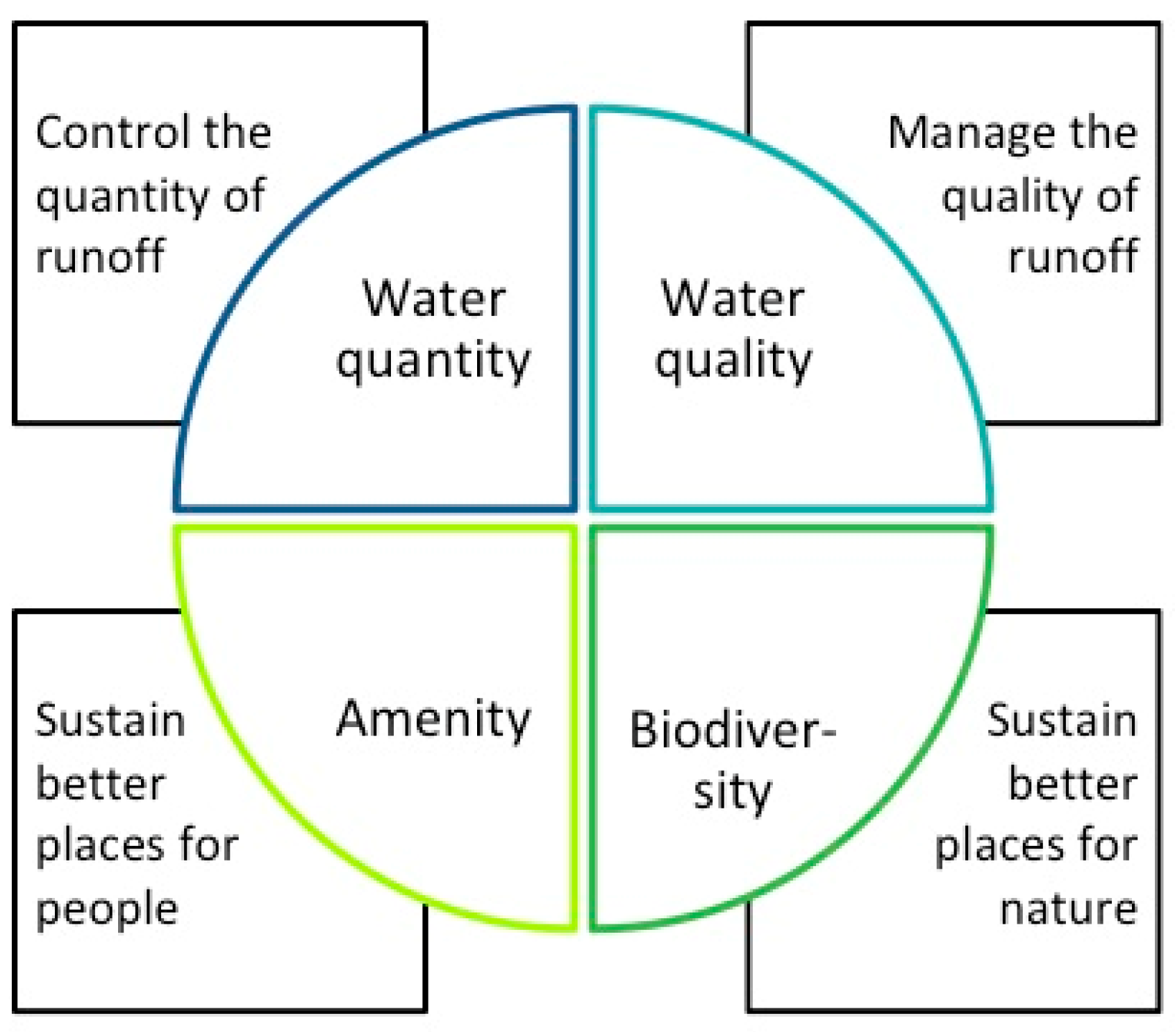
Figure 2.
Detail plan draft of Kirstinpuisto site (figure adapted from the City of Turku).

Figure 3.
Diagram of NORM scenario presenting two parameters of amenity assessment: area of visible SUDS elements (left) and active spaces with vegetated SUDS elements close by (right).
Figure 3.
Diagram of NORM scenario presenting two parameters of amenity assessment: area of visible SUDS elements (left) and active spaces with vegetated SUDS elements close by (right).

Figure 4.
Diagram of NORM scenario presenting two parameters of biodiversity assessment: SUDS elements with structural heterogeneity index value (left) and edge lines of two vegetated surfaces (right).
Figure 4.
Diagram of NORM scenario presenting two parameters of biodiversity assessment: SUDS elements with structural heterogeneity index value (left) and edge lines of two vegetated surfaces (right).

Figure 5.
The cumulative distribution of the flow rate for the current state and the three SUDS scenarios for the longer simulation E1 (a) and zoomed-in cumulative distribution of the high flow rates (b).
Figure 5.
The cumulative distribution of the flow rate for the current state and the three SUDS scenarios for the longer simulation E1 (a) and zoomed-in cumulative distribution of the high flow rates (b).

Figure 6.
Mutual interconnections of the four criteria.


Table 1.
Description of RUN (supplementing the existing pipe network on streets and in the central park with open swales) scenario.
Table 1.
Description of RUN (supplementing the existing pipe network on streets and in the central park with open swales) scenario.
| Scenario | Intent | Range of SUDS | Area (ha) |
|---|---|---|---|
| RUN | Selection of the SUDS elementes is based on the main objectiv: to delay and conduct water away from the site through above-ground vegetated structures and a supplementing pipe drainage network. Additionally, there are rain gardens to promote on-site treatment. | Vegetated swales  | 0.6 |
Rain gardens  | 0.6 | ||
| SUDS Total | 1.2 | ||
 |  | ||
Table 2.
Description of NORM (adding SUDS elements that allow water detention especially on residential yards) scenario.
Table 2.
Description of NORM (adding SUDS elements that allow water detention especially on residential yards) scenario.
| Scenario | Intent | Range of SUDS | Area (ha) |
|---|---|---|---|
| NORM | Scenario is an upgrade of RUN. It utilises a multiple SUDS approach and additional SUDS are selected based on their ability for local detention, without compromising other urban functions, such as traffic connections and recreation. Bioretention cells are constructed in the yards for stormwater treatment and paved parking lots are replaced with permeable pavement. Use of SUDS is limited to prevailing conventions of the city of Turku; for example, green roofs are only integrated into one-storey buildings. | Vegetated swales  | 0.6 |
Rain gardens  | 0.9 | ||
Green roofs  | 0.4 | ||
Bioretention cell  | 0.1 | ||
Permable pavements  | 1.3 | ||
| SUDS Total | 3.3 | ||
 |  | ||
Table 3.
Description of MAX (maximizing the amount of SUDS elements everywhere—in the central park, residential yards, parking areas, and close to business premises) scenario.
Table 3.
Description of MAX (maximizing the amount of SUDS elements everywhere—in the central park, residential yards, parking areas, and close to business premises) scenario.
| Scenario | Intent | Range of SUDS | Area (ha) |
|---|---|---|---|
| MAX | Scenario is an ambitious upgrade of RUN. The amount of SUDS elements have been maximised and selected based on their ability to store and infiltrate stormwater: all roofs are green and all yards and parking lots are covered with permeable surfaces or extended rain gardens. The internal park area is fully utilised for stomrwater management. | Vegetated swales  | 0.6 |
Rain gardens  | 1.8 | ||
Green roofs  | 3.3 | ||
Permable pavements  | 3.3 | ||
| SUDS Total | 9.0 | ||
 |  | ||
Table 4.
Rainfall events used in the stormwater management model (SWMM) and adaptive neuro-fuzzy inference system (ANFIS) model simulations.
Table 4.
Rainfall events used in the stormwater management model (SWMM) and adaptive neuro-fuzzy inference system (ANFIS) model simulations.
| Events | Rainfall Depth (mm) | Start Date Time | Duration | Peak Intensity (mm/10min) | Return Period | Model |
|---|---|---|---|---|---|---|
| SC1 | 35 | 11.11.2017 11:00 | 7:00 | 2.0 | - | SWMM calibration |
| SC2 | 26 | 26.12.2017 20:10 | 8:50 | 1.2 | - | SWMM calibration |
| SV1 | 18 | 04.01.2018 20:10 | 6:04 | 0.6 | - | SWMM validation |
| E1 | 450 | May 2012 | 7 months | - | - | SWMM scenarios |
| E2 | 71.0 | 27.08.2012 00:00 | 6:04 | 18 | 95 years | SWMM scenarios |
| E3 | 42.0 | 04.10.2012 00:00 | 12:00 | 9 | 30 years | SWMM scenarios |
| AT1 | 46.8 | 13.12.2017 23:40 | 24 days | 0.7 | - | ANFIS training and ANFIS scenarios |
| AT2 | 19.6 | 15.12.2017 19:00 | 10 days | 0.7 | - | ANFIS testing |
Table 5.
Basic statistics of the measured water quality input and output variables.
| Variables | Min * | Max ** | Mean | SD *** | Median | Type |
|---|---|---|---|---|---|---|
| Rainfall depth (mm) | 0.4 | 27.7 | 2.4 | 2.6 | 1.3 | Input |
| Discharge (l/s) | 0.0 | 0.700 | 0.017 | 0.058 | 0.0 | Input |
| Temperature (°C) | 1.7 | 12.4 | 6.6 | 1.3 | 7.2 | Input |
| Electrical conductivity (µS/cm) | 33.0 | 701.0 | 497.7 | 152.0 | 557.0 | Input |
| Turbidity (NTU) | 0.1 | 560.3 | 27.4 | 60.4 | 2.4 | Output |
* Min, minimum; ** Max, maximum; *** SD, standard deviation.
Table 6.
Changes in peak flow, total runoff, and flood volume for SUDS scenarios compared to the current state. Increase in losses also shown for the seven-month period, E1.
Table 6.
Changes in peak flow, total runoff, and flood volume for SUDS scenarios compared to the current state. Increase in losses also shown for the seven-month period, E1.
| Events | Scenarios | Peakflow Rate with SUDS [l/s] | Current State Peak Flow (l/s) | Decrease in Peak Flow (%) | Reduction in Total Volume (%) | Reduction in Flooding Volume (%) | Increase in Losses (%) |
|---|---|---|---|---|---|---|---|
| E1 | RUN | 1493 | 1876 | 20.5 | 2.0 | 66.0 | 1.2 |
| NORM | 989 | 1876 | 47.3 | 39.9 | 81.1 | 30.9 | |
| MAX | 458 | 1876 | 75.6 | 81.0 | 98.7 | 58.9 | |
| E2 | RUN | 1493 | 1834 | 18.6 | 1.4 | 65.0 | – |
| NORM | 957 | 1834 | 47.8 | 25.6 | 81.8 | – | |
| MAX | 442 | 1834 | 75.9 | 67.8 | 98.9 | – | |
| E3 | RUN | 360 | 474 | 24.2 | -8.8 | 91.1 | – |
| NORM | 249 | 474 | 47.6 | 33.8 | 98.5 | – | |
| MAX | 94 | 474 | 80.3 | 82.0 | 100.0 | – |
Table 7.
Reduction in mean turbidity, and concentrations of total suspended solids, chromium, and copper for SUDS scenarios compared to the current state.
Table 7.
Reduction in mean turbidity, and concentrations of total suspended solids, chromium, and copper for SUDS scenarios compared to the current state.
| Unit | RUN | NORM | MAX | Linear Relationship | Coefficient of Determination (R2) | a* (95% CI ** of a) | |
|---|---|---|---|---|---|---|---|
| Turbidity (T) | NTU | −1.6% | 11.6% | 46.5% | – | – | |
| Total suspended solids (TSS) | mg/l | −0.4% | 3.0% | 12.2% | TSS = aT + 46.763 | 0.89 | 0.404 (0.332, 0.477) |
| Chromium (Cr) | µg/l | −2.6% | 18.3% | 73.5% | Cr = aT − 4.10 | 0.95 | 0.067 (0.061, 0.073) |
| Copper (Cu) | µg/l | −0.2% | 1.7% | 6.8% | Cu = aT + 15.411 | 0.83 | 0.064 (0.049, 0.079) |
* a, slope of regression line; ** CI, confidence interval.
Table 8.
Total scores of amenity values.
| Elements | RUN | NORM | MAX | |
|---|---|---|---|---|
| Visible SUDS elements | Swales | 0.6 | 0.6 | 0.6 |
| Rain gardens | 0.6 | 0.9 | 1.8 | |
| Bioretention cell | 0.1 | |||
| Visible green roofs | 0.4 | 0.4 | ||
| 1.2 | 2 | 2.8 | ||
| Active Spaces Close SUDS elements | Lawns | 1.7 | 0.7 | |
| Urban Square | 0.3 | 0.3 | 0.1 | |
| Yards | 1.9 | 1.8 | ||
| 2 | 2.9 | 1.9 | ||
| Total Score | (ha) | 3.2 | 4.9 | 4.7 |
Table 9.
Total scores of structural heterogeneity (left) and edge line (right).
| Elements | RUN | NORM | MAX | Elements | RUN | NORM | MAX |
|---|---|---|---|---|---|---|---|
| Swales (18) | 11 | 11 | 11 | Between two SUDS el. | 945 | 875 | |
| Rain gardens (10) | 6 | 9 | 18 | Between SUDS el. and lawn | 875 | 410 | |
| Bioretention cell (22) | 2 | Total score | 875 | 1355 | 875 | ||
| Total score | 17 | 22 | 29 |
© 2019 by the authors. Licensee MDPI, Basel, Switzerland. This article is an open access article distributed under the terms and conditions of the Creative Commons Attribution (CC BY) license (http://creativecommons.org/licenses/by/4.0/).
Share and Cite
MDPI and ACS Style
Lähde, E.; Khadka, A.; Tahvonen, O.; Kokkonen, T. Can We Really Have It All?—Designing Multifunctionality with Sustainable Urban Drainage System Elements. Sustainability 2019, 11, 1854. https://doi.org/10.3390/su11071854
AMA Style
Lähde E, Khadka A, Tahvonen O, Kokkonen T. Can We Really Have It All?—Designing Multifunctionality with Sustainable Urban Drainage System Elements. Sustainability. 2019; 11(7):1854. https://doi.org/10.3390/su11071854
Chicago/Turabian StyleLähde, Elisa, Ambika Khadka, Outi Tahvonen, and Teemu Kokkonen. 2019. "Can We Really Have It All?—Designing Multifunctionality with Sustainable Urban Drainage System Elements" Sustainability 11, no. 7: 1854. https://doi.org/10.3390/su11071854
Note that from the first issue of 2016, this journal uses article numbers instead of page numbers. See further details here.