Land Cover Change in the Abuja City-Region, Nigeria: Integrating GIS and Remotely Sensed Data to Support Land Use Planning


 ,
, 
Abstract
1. Introduction
2. Materials and Methods
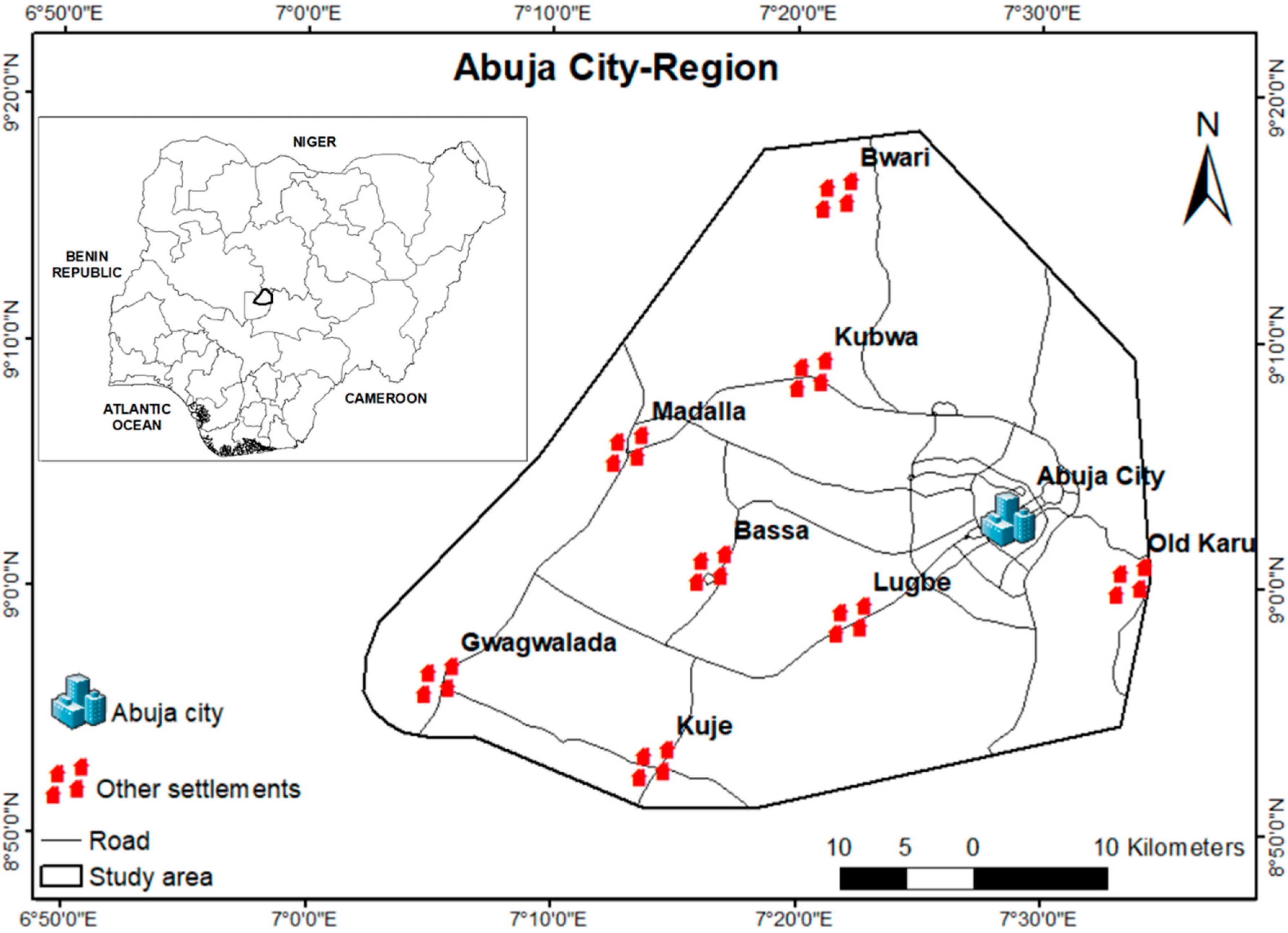
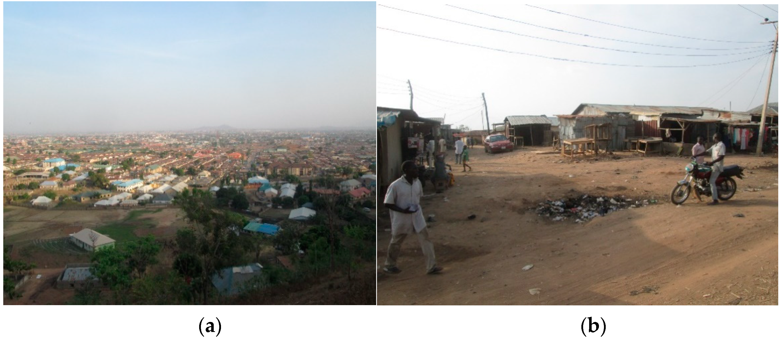
2.1. Study Area
2.2. Data Collection
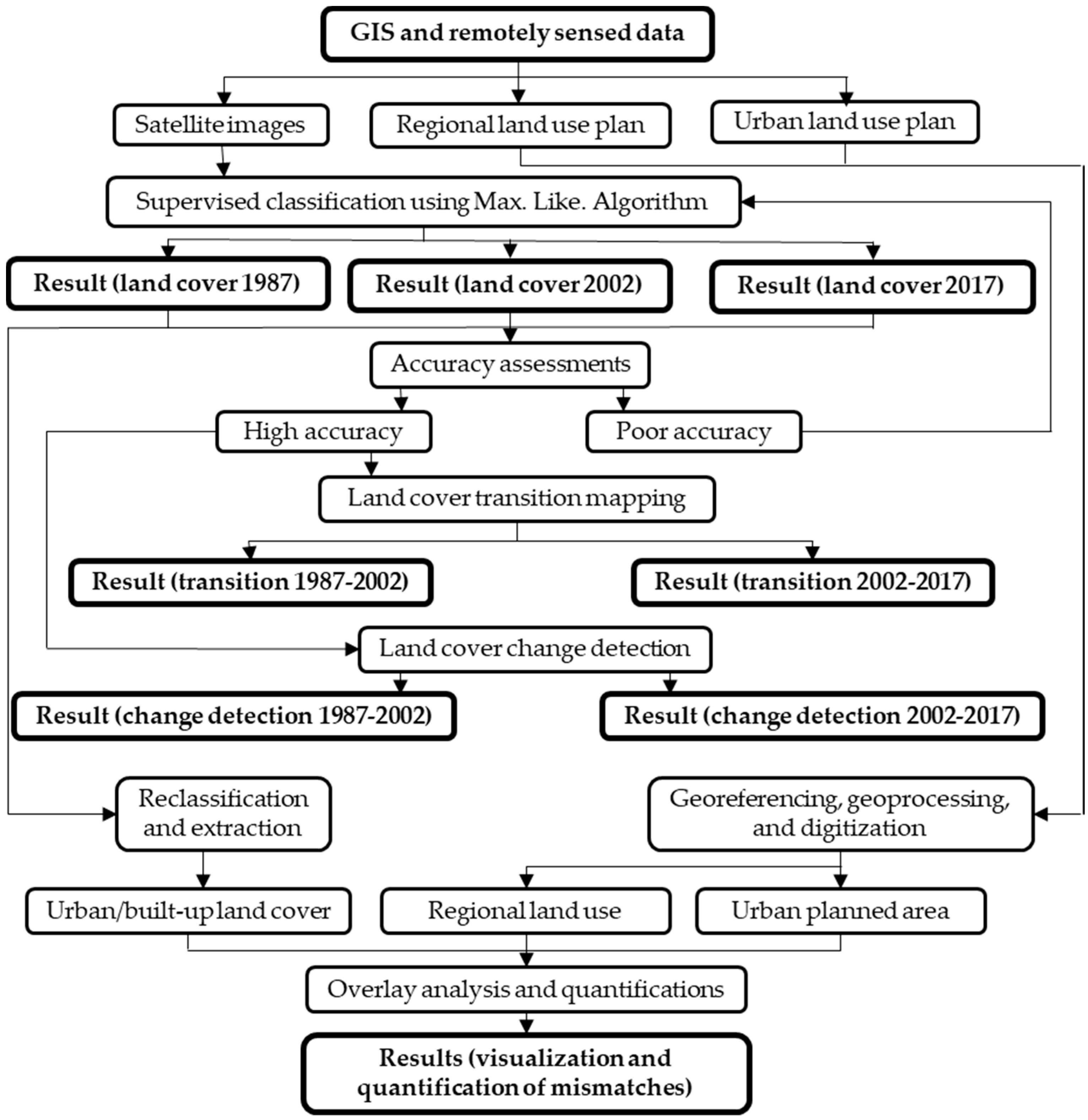
2.3. Data Analysis
3. Results
4. Discussion
5. Conclusions
Author Contributions
Acknowledgments
Conflicts of Interest
References
- Nor, A.N.M.; Corstannje, R.; Harris, J.A.; Brewer, T. Impact of rapid urban expansion on green space structure. Ecol. Indic. 2017, 81, 274–284. [Google Scholar] [CrossRef]
- Zhou, Y.; Li, X.; Asrar, G.R.; Smith, S.J.; Imhoff, M. A global record of annual urban dynamics (1992–2013) from nighttime lights. Remote Sens. Environ. 2018, 219, 206–220. [Google Scholar] [CrossRef]
- Angel, S.; Parent, J.; Civco, D.L.; Blei, A.; Potere, D. The dimensions of global urban expansion: Estimates and projections for all countries, 2000–2050. Prog. Plan. 2011, 75, 53–107. [Google Scholar] [CrossRef]
- Vasenev, V.I.; Stoorvogal, J.J.; Leemans, R.; Valentini, R.; Hajiaghayeva, R.A. Projection of urban expansion and related changes in soil carbon stocks in the Moscow Region. J. Clean. Prod. 2018, 170, 902–914. [Google Scholar] [CrossRef]
- Kukkonen, M.O.; Muhammad, M.J.; Käyhkö, N.; Luoto, M. Urban expansion in Zanzibar City, Tanzania: Analyzing quantity, spatial patterns and effects of alternative planning approaches. Land Use Policy 2018, 71, 554–565. [Google Scholar] [CrossRef]
- Tiitu, M. Expansion of the built-up areas in Finnish city regions—The approach of travel-related urban zones. Appl. Geogr. 2018, 101, 1–13. [Google Scholar] [CrossRef]
- Akpu, B.; Tanko, A.I.; Jeb, D.N.; Dogo, B. Geospatial Analysis of Urban Expansion and Its Impact on Vegetation Cover in Kaduna Metropolis, Nigeria. AJEE 2017, 3, 31149. [Google Scholar] [CrossRef]
- Owoeye, J.O.; Ibitoye, O.A. Analysis of Akure Urban Land Use Change Detection from Remote Imagery Perspective. Urban Stud. Res. 2016, 2016, 4673019. [Google Scholar] [CrossRef]
- Gibson, J.; Boe-Gibson, G.; Stichbury, G. Urban land expansion in India 1992–2012. Food Pol. 2015, 56, 100–113. [Google Scholar] [CrossRef]
- Quan, B.; Bai, Y.; Romkens, M.J.M.; Chang, K.; Song, H.; Guo, T.; Lei, S. Urban land expansion in Quanzhou City, China, 1995–2010. Habitat Int. 2015, 48, 131–139. [Google Scholar] [CrossRef]
- Fanan, U.; Dlama, K.I.; Oluseyi, I.O. Urban expansion and vegetal cover loss in and around Nigeria’s Federal Capital City. J. Ecol. Nat. Environ. 2011, 3, 1–10. Available online: https://academicjournals.org/journal/JENE/article-abstract/CE94A3B5892 (accessed on 20 December 2017).
- Barrera, F.D.L.; Henríquez, C. Vegetation cover change in growing urban agglomerations in Chile. Ecol. Indic. 2017, 81, 265–273. [Google Scholar] [CrossRef]
- Nwokoro, I.I.; Dekolo, S.O. Land use change and environmental sustainability: The case of Lagos Metropolis. In Sustainable City VII: Urban Regeneration and Sustainability; Pacetti, M., Passerini, G., Brebbia, C.A., Latini, G., Eds.; WIT Press: Southampton, UK, 2012; Volume 155, pp. 157–167. [Google Scholar]
- Morelli, J. Environmental Sustainability: A Definition for Environmental Professionals. J. Environ. Sustain. 2011, 1, 19–27. [Google Scholar] [CrossRef]
- Abdullahi, S.; Pradhan, B. Sustainable Urban Development. In Spatial Modeling and Assessment of Urban Form Analysis of Urban Growth: From Sprawl to Compact Using Geospatial Data, 1st ed.; Pradhan, B., Ed.; Springer International Publishing AG: Basel, Switzerland, 2017; pp. 17–34. ISBN 978-3-319-54216-4. [Google Scholar]
- Yin, J. Urban Planning for Dummies, 3rd ed.; John Wiley & Sons Canada Ltd.: Mississauga, ON, Canada, 2012. [Google Scholar]
- UN-Habitat. State of the World’s Cities 2010/2011: Bridging the Urban Divide; Earthscan Publishing for a Sustainable Future: London, UK, 2008. [Google Scholar]
- Phillips, P.M.; João, E. Land use planning and the ecosystem approach: An evaluation of case study planning frameworks against the Malawi Principles. Land Use Policy 2017, 68, 460–480. [Google Scholar] [CrossRef]
- BMZ. Land Use Planning: Concept, Tools and Applications; GIZ: Eschborn, Germany, 2012. [Google Scholar]
- Metternicht, G. Global Land Outlook Working Paper: Land Use Planning; UNCCD (United Nations Convention to Combat Desertification): Sydney, Australia, 2017. [Google Scholar]
- Schug, F.; Okujeni, A.; Hauer, J.; Hostert, P.; Nielsen, J.O.; van der Linden, S.F. Mapping pattern of urban development in Ouagadougou, Burkina Faso, using machine learning regression modeling with bi-seasonal Landsat time series. Remote Sens. Environ. 2018, 210, 217–228. [Google Scholar] [CrossRef]
- Aribigbola, A. Constraints to Urban Land Use Planning and Management in Nigeria: Evidence from Ondo State. J. Environ. 2013, 2, 66–73. Available online: https://www.scientific-journals.co.uk/web_documents/4020311_constraints_urban_land_use.pdf (accessed on 21 December 2017).
- Potts, D. Challenging the Myths of Urban Dynamics in Sub-Saharan Africa: The Evidence from Nigeria. World Dev. 2012, 40, 1382–1393. [Google Scholar] [CrossRef]
- Africa in Focus Figure of the Week: Africa is Home to the 10 Fastest Growing Cities in The World. Available online: https://www.brookings.edu/blog/africa-in-focus/2018/10/05/figure-of-the-week-africa-is-home-to-fastest-growing-cities-in-the-world/ (accessed on 5 October 2018).
- Mahmoud, M.I.; Duker, A.; Conrad, C.; Thiel, M.; Ahmad, H.S. Analysis of Settlement Expansion and Urban Growth Modelling Using Geoinformation for Assessing Potential Impacts of Urbanization on Climate in Abuja City, Nigeria. Remote Sens. 2016, 8, 220. [Google Scholar] [CrossRef]
- Nkeki, F.N. Spatio-temporal analysis of land use transition and urban growth characterization in Benin metropolitan region, Nigeria. Remote Sens. Appl. Soc. Environ. 2016, 4, 119–137. [Google Scholar] [CrossRef]
- Akintunde, J.A.; Adzandeh, E.A.; Fabiyi, O.O. Spatio-temporal pattern of urban growth in Jos Metropolis, Nigeria. Remote Sens. Appl. Soc. Environ. 2016, 4, 44–54. [Google Scholar] [CrossRef]
- Hou, H.; Estoque, R.C.; Murayama, Y. Spatiotemporal analysis of urban growth in three African capital cities: A grid-cell-based analysis using remote sensing data. J. Afr. Earth Sci. 2016, 123, 381–391. [Google Scholar] [CrossRef]
- Liu, F.; Zhang, Z.; Zhao, X.; Wang, X.; Zuo, L.; Wen, Q.; Yi, L.; Xu, J.; Hu, S.; Liu, B. Chinese cropland losses due to urban expansion in the past four decades. Sci. Total Environ. 2019, 650, 847–857. [Google Scholar] [CrossRef] [PubMed]
- Abubakar, I.R. Abuja city profile. Cities 2014, 41, 81–91. [Google Scholar] [CrossRef]
- FMITI (Federal Ministry of Industry, Trade and Investment). Resettlement and Social Audit: Abuja Technology Village Project; FMITI: Abuja, Nigeria, 2015.
- COHRE (The Centre on Housing Rights and Evictions); SERAC (Social and Economic Rights Action Centre). The Myth of Abuja Master Plan: Forced Evictions as Urban Planning in Abuja, Nigeria; COHRE: Geneva, Switzerland, 2008; ISBN 978-92-95004-43-6. [Google Scholar]
- Idoko, M.A.; Bisong, F.E. Application of Geo-Information for Evaluation of Land Use Change: A Case Study of Federal Capital Territory-Abuja. Environ. Res. J. 2010, 4, 140–144. [Google Scholar] [CrossRef]
- Omole, F.K. Land use violations: Implication for sustainable development, the case study of the Federal Capital City Abuja, Nigeria. Curr. Res. J. Soc. Sci. 2009, 1, 31–37. Available online: https://maxwellsci.com/jp/abstract.php?jid=CRJSS&no=3&abs=6 (accessed on 22 December 2017).
- City Population: Federal Capital Territory, Nigeria. Available online: https://www.citypopulation.de/php/nigeria-admin.php?adm1id=NGA015 (accessed on 22 December 2017).
- DEPRS (Department of Economic Planning and Research Statistics). 2015 Statistical Year Book; National Bureau of Statistics: Abuja, Nigeria, 2015.
- Ujoh, F.; Kwabe, I.D.; Ifatimehin, O.O. Understanding urban sprawl in the Federal Capital City, Abuja: Towards sustainable urbanization in Nigeria. J. Geogr. Reg. Plann. 2010, 3, 106–113. Available online: https://academicjournals.org/journal/JGRP/article-abstract/5DEAA5539644 (accessed on 6 January 2018).
- Jibril, I.U. Planning and Land Administration Challenges in Developing New Cities: The Abuja Experience in Nigeria. In Proceedings of the FIG Working Week, Sofia, Bulgaria, 17–21 May 2015. [Google Scholar]
- Aliyu, R. Designing for Sustainable Communities: The Abuja Federal Capital Territory of Nigeria. Ph.D. Thesis, De Montfort University Leicester, Leicester, UK, June 2016. [Google Scholar]
- Jelili, M.O.; Adedibu, A.A.; Egunjobi, L. Regional Development Planning in Nigeria: The General and Particular. J. Soc. Sci. 2008, 16, 135–140. [Google Scholar] [CrossRef]
- Usman, I.J. An evaluation of the influence of Land-Use/Cover Change on the Surface Temperature of Federal Capital City (Abuja) Using Remote Sensing and GIS. Master’s Thesis, Ahmadu Bello University Zaria, Zaria, Nigeria, February 2014. [Google Scholar]
- Edicha, J.A.; Mgbanyi, L.L.O. Assessment of soil structural stability under different vegetal cover conditions in the Federal Capital Territory, Abuja, Nigeria. Niger. Geogr. J. 2013, 9, 110–121. Available online: https://www.researchgate.net/publication/274384618 (accessed on 22 December 2017).
- USGS (United States Geological Survey). Available online: https://earthexplorer.usgs.gov (accessed on 10 June 2017).
- AGIS (Abuja Geographic Information Systems). FCT Regional Plan 2000: Proposed Landuse; AGIS: Abuja, Nigeria, 2007.
- Fola Consult Ltd. Federal Capital City: Revised Land Use Plan—2011 Phases I, II & III; Federal Capital Development Authority: Abuja, Nigeria, 2011.
- Campbell, J.B.; Wynne, R.H. Introduction to Remote Sensing, 5th ed.; The Guilford Press: New York, NY, USA, 2011. [Google Scholar]
- Lu, D.; Weng, Q.; Moran, E.; Li, G.; Hetrick, S. Remote Sensing Image Classification. In Advances in Environmental Remote Sensing: Sensors, Algorithms, and Applications, 1st ed.; Weng, Q., Ed.; Tailor & Francis Group: Boca Raton, FL, USA, 2011; pp. 219–240. ISBN 978-1-4200-9175-5. [Google Scholar]
- Tso, B.; Mather, P.M. Classification Methods for Remotely Sensed Data, 2nd ed.; Taylor & Francis Group, LLC: Boca Raton, FL, USA, 2009; ISBN 978-1-42009072-7. [Google Scholar]
- Ganasri, B.P.; Dwarakish, G.S. Study of land use/land cover dynamics through classification algorithms for Harangi catchment area, Karnataka State, INDIA. Aquat. Procedia 2015, 4, 1413–1420. [Google Scholar] [CrossRef]
- Olofsson, P.; Foody, G.M.; Herold, M.; Stehman, S.V.; Woodcock, C.E.; Wulder, M.A. Good practices for estimating area and assessing accuracy of land change. Remote Sens. Environ. 2014, 148, 42–57. [Google Scholar] [CrossRef]
- Yang, X. Integration of Remote Sensing with GIS for Urban Growth Characterization. In Geospatial Analysis and Modelling of Urban Structure and Dynamics, 1st ed.; Jiang, B., Yao, X., Eds.; Springer Science + Business Media B.V.: New York, NY, USA, 2010; pp. 223–250. ISBN 978-90-481-8571-9. [Google Scholar]
- Elagouz, M.H.; Abou-Shleel, S.M.; Belal, A.A.; El-Mohandes, M.A. Detection of land use/cover change in Egyptian Nile Delta using remote sensing. Egypt. J. Remote Sens. Space Sci. 2019. [Google Scholar] [CrossRef]
- Shen, X.; Wang, X.; Zhang, Z.; Lu, Z.; Lv, T. Evaluating the effectiveness of land use plans in containing urban expansion: An integrated view. Land Use Policy 2019, 80, 205–213. [Google Scholar] [CrossRef]
- Hassan, M.M. Monitoring land use/land cover change, urban growth dynamics and landscape pattern analysis in five fastest urbanized cities in Bangladesh. Remote Sens. Appl. Soc. Environ. 2017, 7, 69–83. [Google Scholar] [CrossRef]
- Gottdiener, M.; Budd, L.; Lehtovuori, P. Key Concepts in Urban Studies; Saga Publications Ltd.: London, UK, 2016; ISBN 978-1-84920-198-8. [Google Scholar]
- Lall, S.V.; Henderson, V.J.; Venables, A.J. Africa’s Cities: Opening Doors to the World; International Bank for Reconstruction and Development/The World Bank: Washington, DC, USA, 2017; pp. 1–162. ISBN 978-1-4648-1044-2. [Google Scholar]
- Zubair, O.A.; Ojigi, L.M.; Mbih, R.A. Urbanization: A Catalyst for the Emergence of Squatter Settlements and Squalor in the Vicinities of the Federal Capital City of Nigeria. J. Sustain. Dev. 2015, 8, 134–148. [Google Scholar] [CrossRef]
- Freire, M.O.; Lall, S.; Leipzige, D. Africa’s Urbanization: Challenges and Opportunities; Working Paper No. 7; The Growth Dialogue: Washington, DC, USA, 2014; pp. 1–30. [Google Scholar]
- Trefon, T. Hings and fringes: Conceptualising the peri-urban in Central Africa. In African Cities: Completing Claims on Urban Spaces, 1st ed.; Locatelli, F., Nugent, P., Eds.; Koninklijke Brill NV: Leiden, The Netherlands, 2009; Volume 3, pp. 15–36. ISBN 9789047442486. [Google Scholar]
- Goodfellow, T. Planning and development regulation amid rapid urban growth: Explaining divergent trajectories in Africa. Geoforum 2013, 48, 83–93. [Google Scholar] [CrossRef]
- Barry, M.; Danso, E.K. Tenure security, land registration and customary tenure in a peri-urban Accra community. Land Use Policy 2014, 39, 358–365. [Google Scholar] [CrossRef]


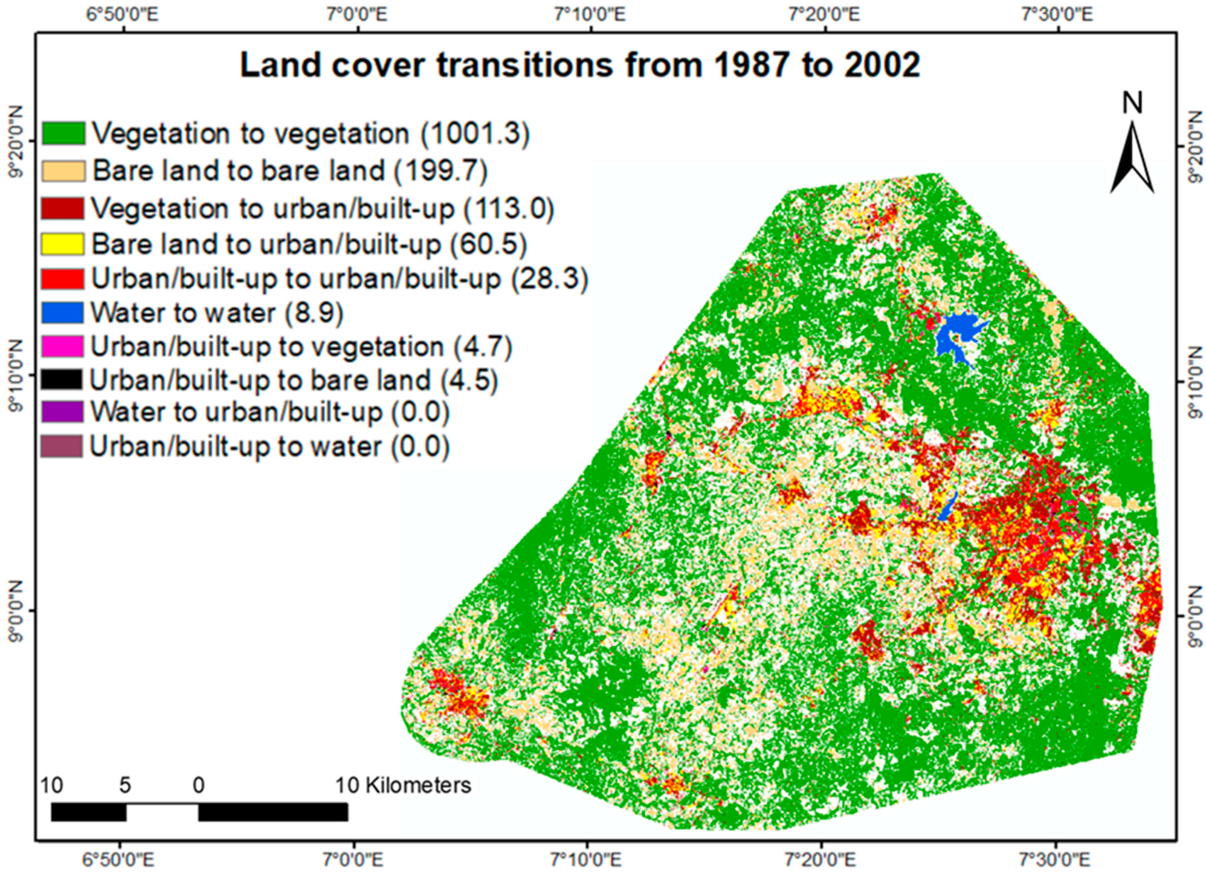
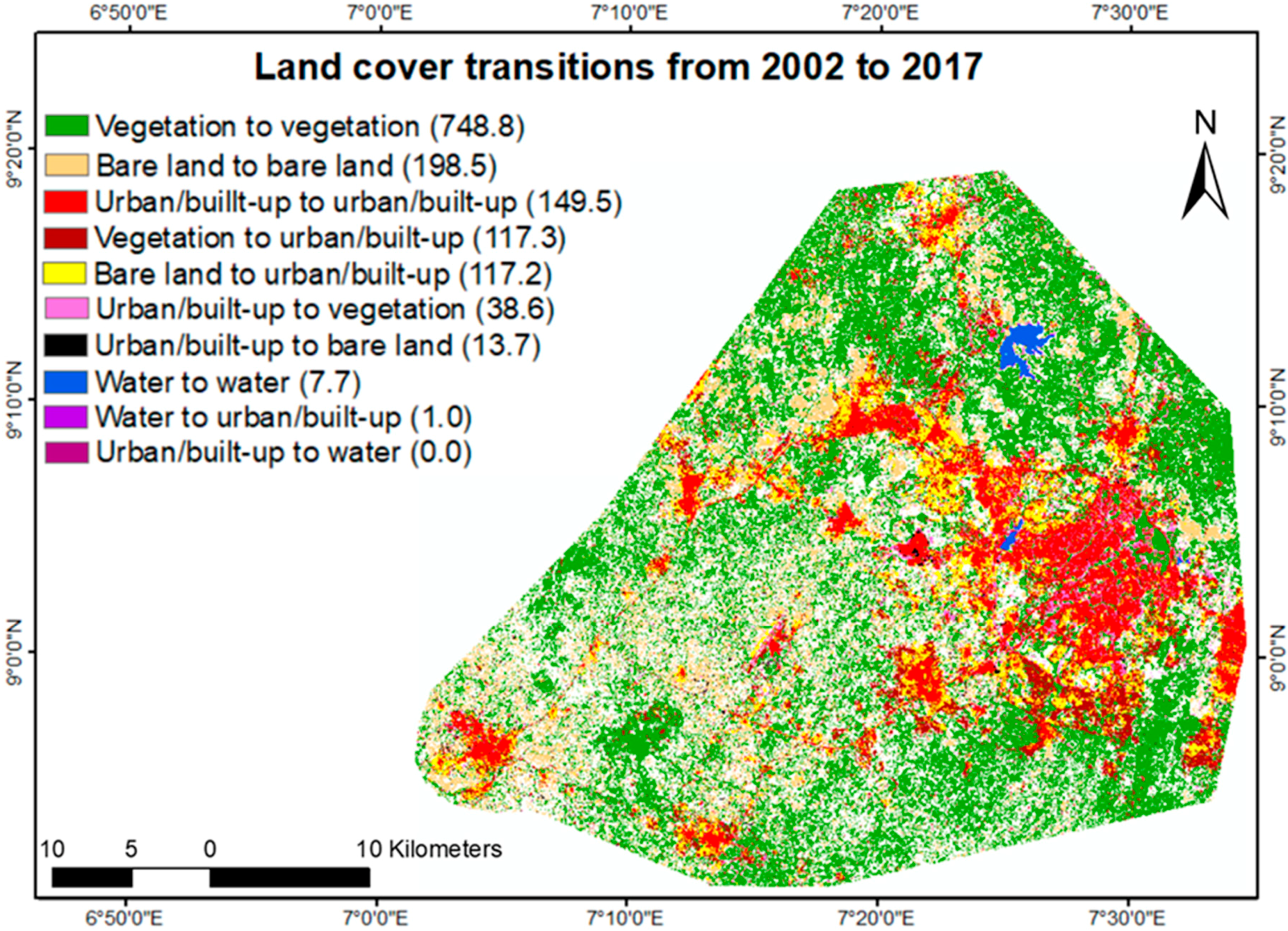
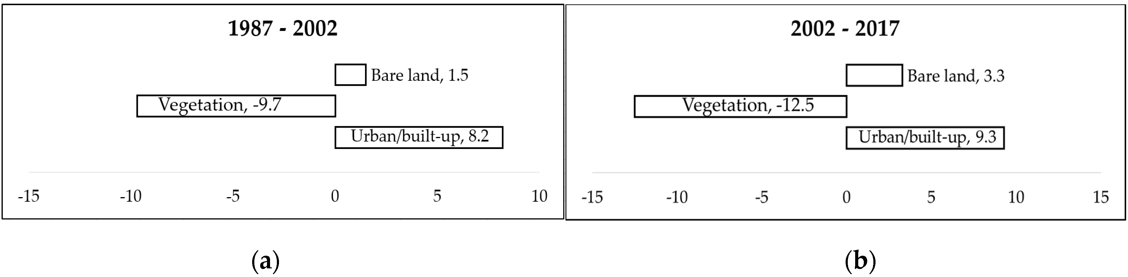
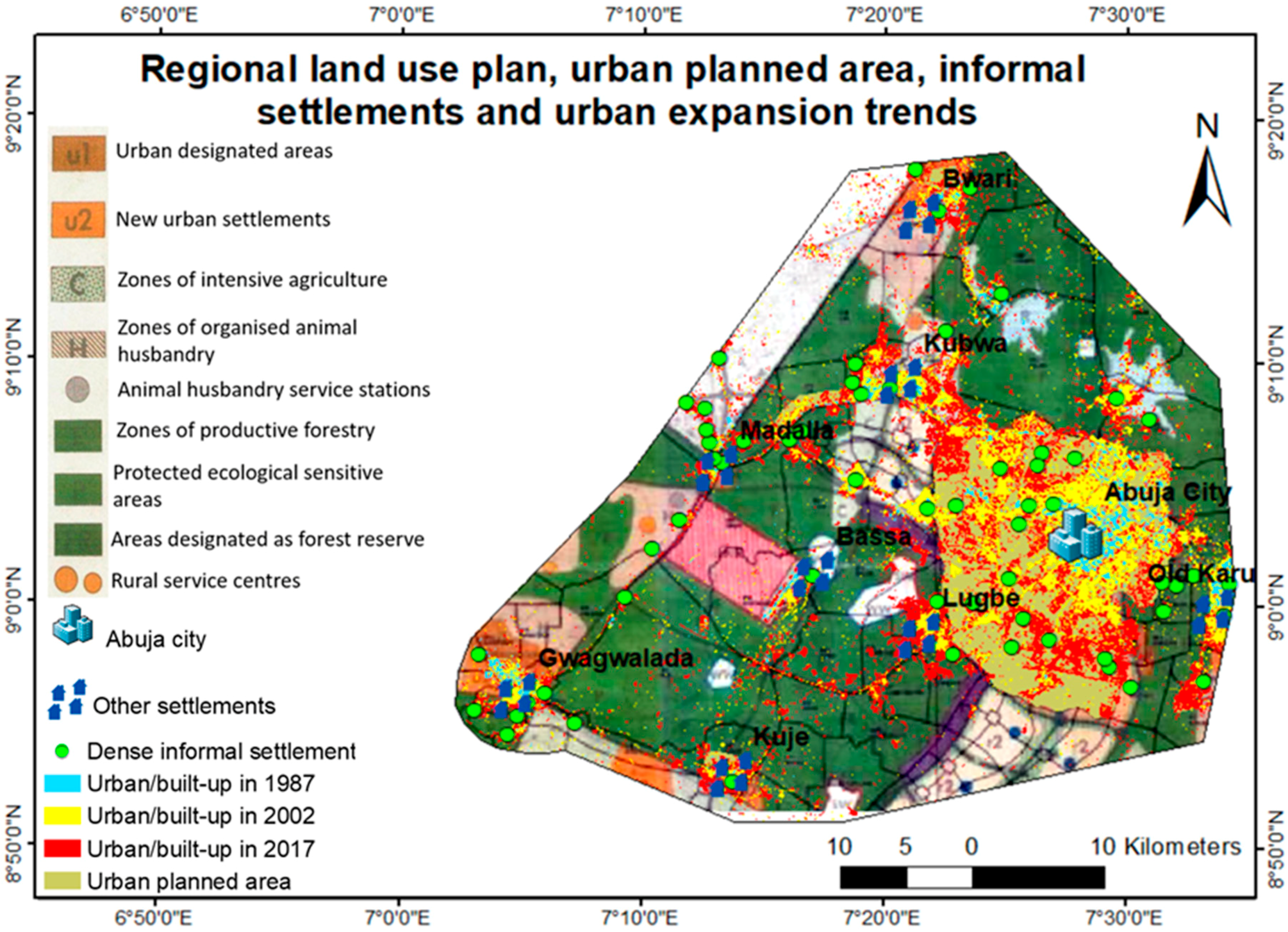
| Landsat Series | Sensor | Spatial Resolution | No: of Bands | Date of Acquisition | Sources |
|---|---|---|---|---|---|
| Landsat 4 | TM | 30 m | 7 | 21/12/1987 | USGS |
| Landsat 7 | ETM+ | 30 m | 9 | 30/12/2002 | USGS |
| Landsat 8 | OLI | 30 m | 11 | 14/02/2017 | USGS |
| Land Cover Classes | Description of Land Cover |
|---|---|
| Urban/built-up | Elements of urban/rural settlements such as buildings, roads, etc. |
| Vegetation | Forest vegetation: Tall trees that form canopy as healthy vegetation. Savannah vegetation: Isolated short trees mixed with grasses. |
| Bare land | All other surfaces such as open space with bare soil, rocks. |
| Water | Lakes and other water bodies. |
| Land Cover Classes | 1987 | 2002 | 2017 |
|---|---|---|---|
| Area km2 (% of Study Area) | Area km2 (% of Study Area) | Area km2 (% of Study Area) | |
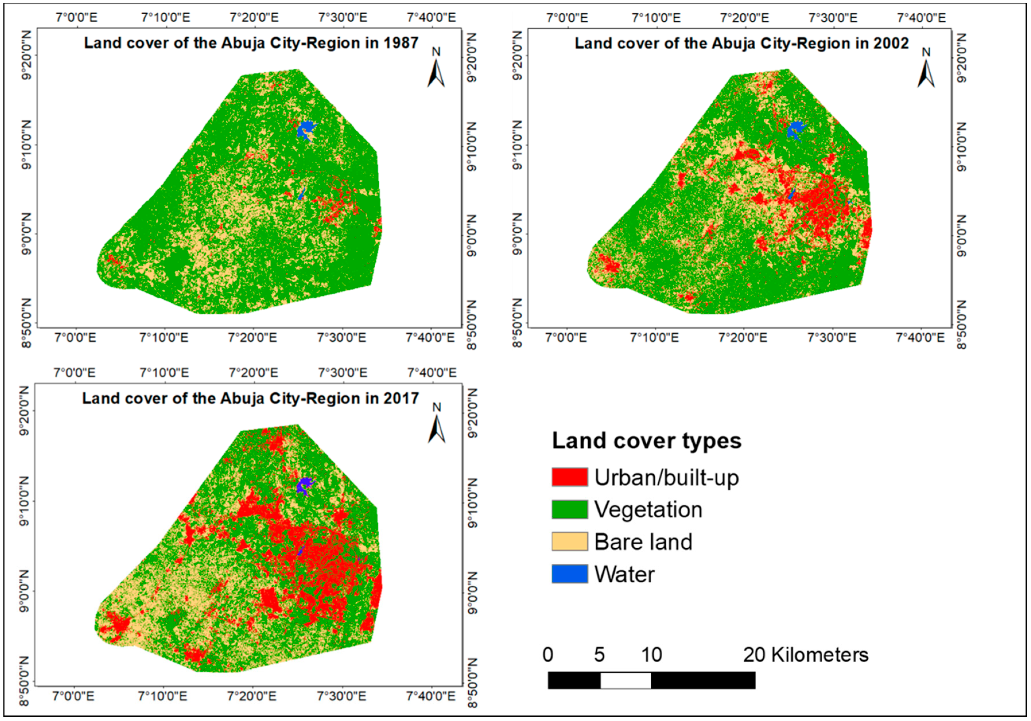
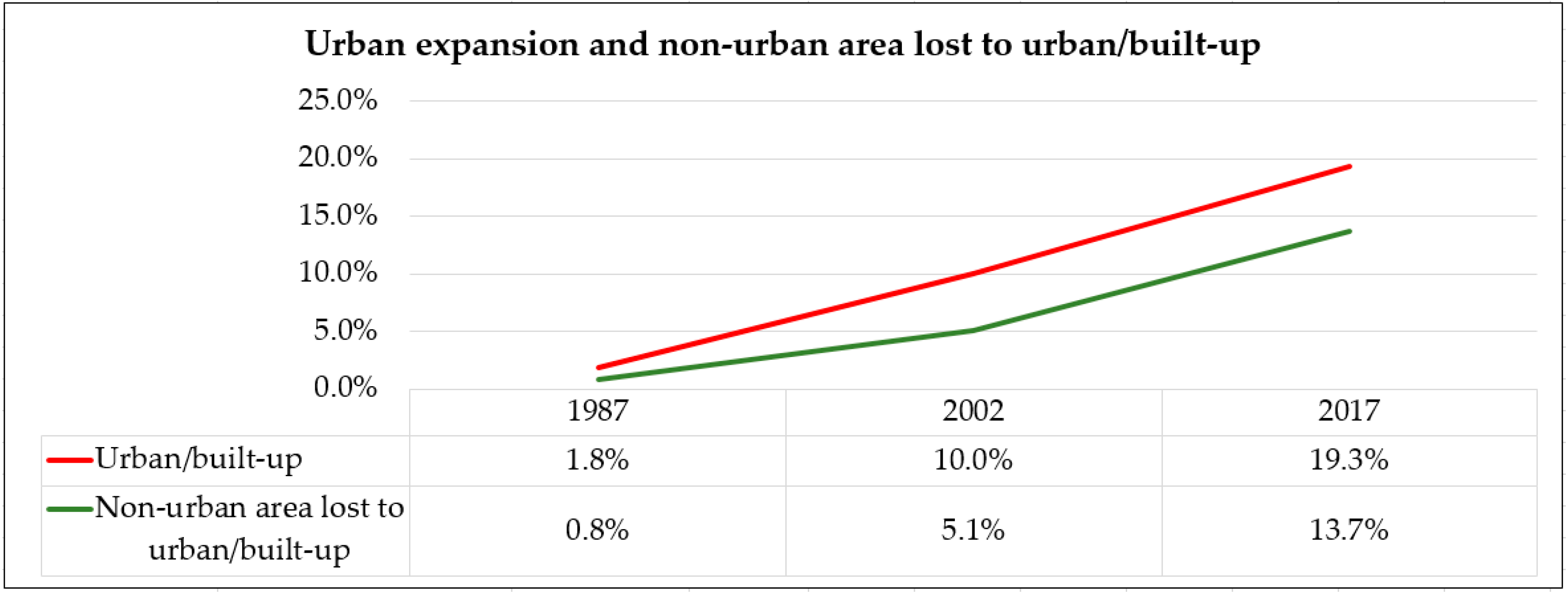
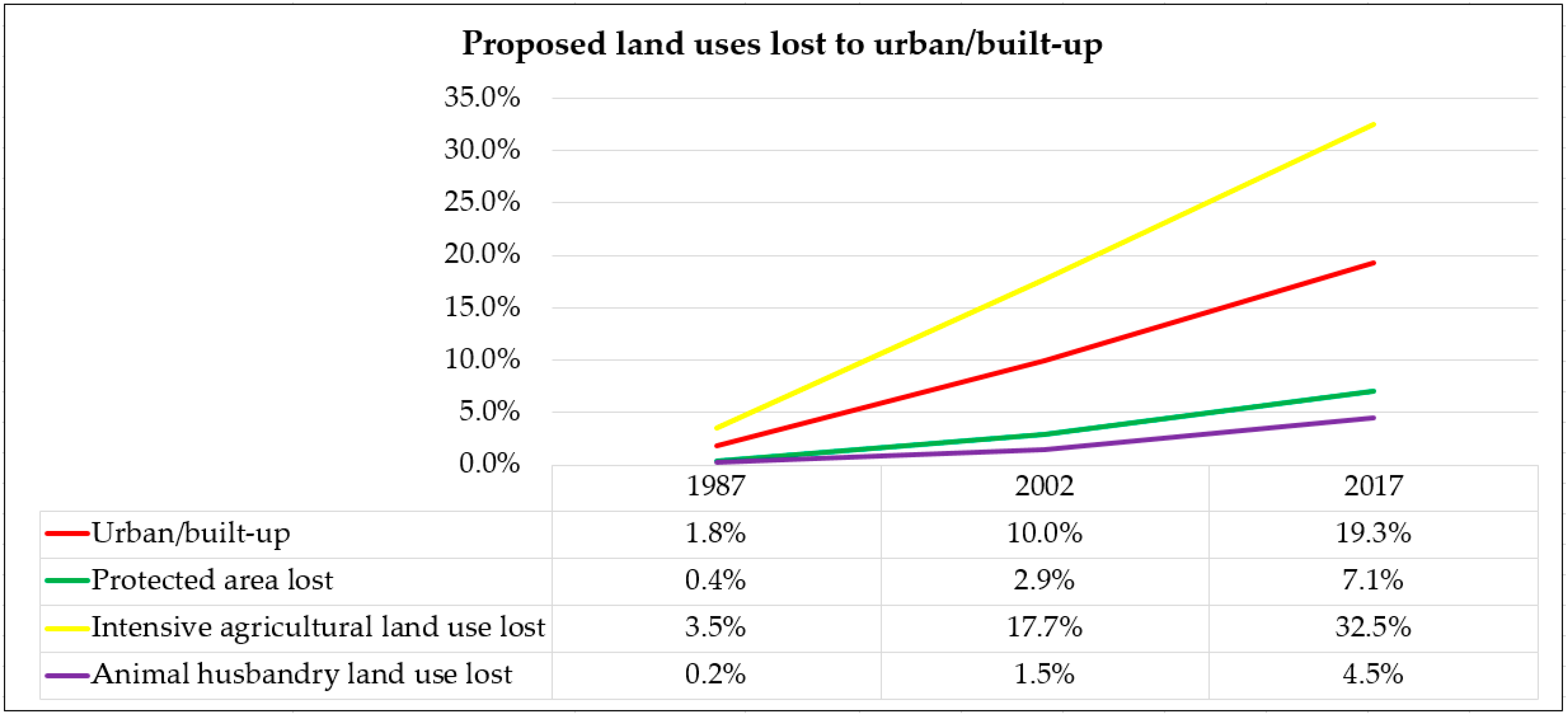
| Urban/built-up | 36.8 (1.8%) | 198.8 (10.0%) | 385.4 (19.3%) |
| Vegetation | 1455.6 (73.0%) | 1262.5 (63.3%) | 1011.9 (50.8%) |
| Bare land | 491.9 (24.7%) | 522.1 (26.2%) | 588.6 (29.5%) |
| Water | 9.3 (0.5%) | 9.6 (0.5%) | 7.7 (0.4%) |
| Total | 1993.6 (100.0%) | 1993.0 (100.0%) | 1993.6 (100.0%) |
| Land Cover Classes | 1987 | 2002 | 2017 | |||||||||
|---|---|---|---|---|---|---|---|---|---|---|---|---|
| UA | PA | OA | KC | UA | PA | OA | KC | UA | PA | OA | KC | |
| Urban/built-up | 91% | 94.8% | 94% | 0.91 | 88% | 87.8% | 92.6% | 0.89 | 96% | 85.3% | 94% | 0.91 |
| Vegetation | 97.5% | 97.5% | 94.5% | 95.9% | 95% | 98.4% | ||||||
| Bare land | 93.3% | 88.6% | 94.7% | 89.3% | 94.7% | 94% | ||||||
| Water | 88% | 95.6% | 88% | 95.7% | 84% | 97.7% | ||||||
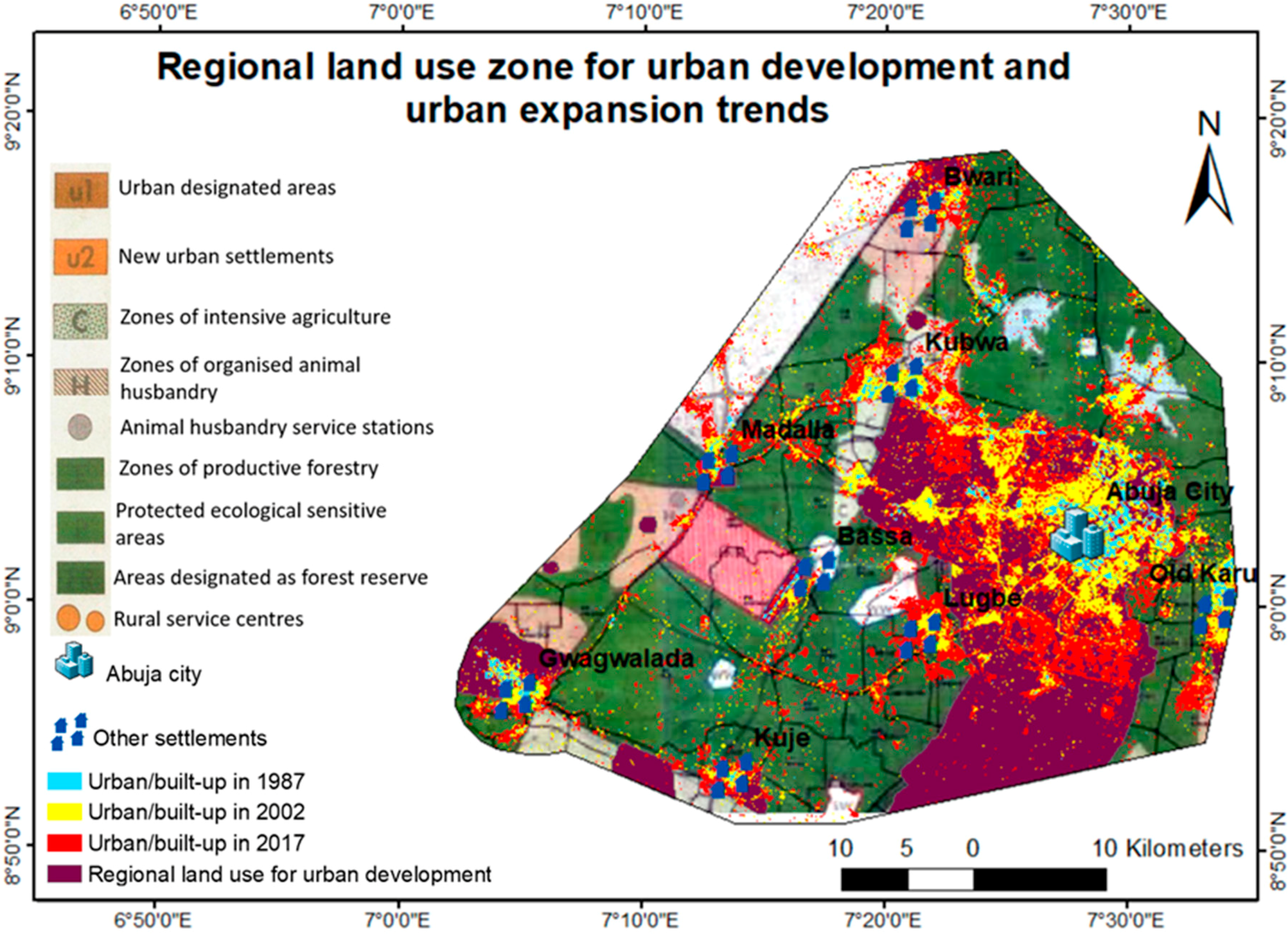
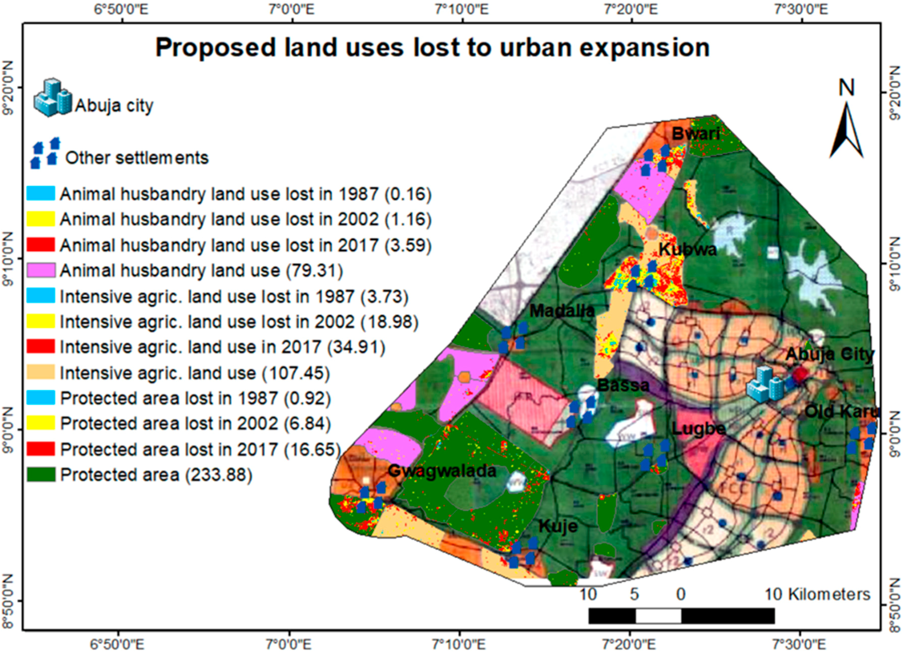
| Years | Regional Planned Area for Urban Development in km2 | Urban/Built-up Area in km2 | Urban/Built-up in Non-urban Development Area in km2 |
|---|---|---|---|
| 1987 | 555.25 | 36.8 | 11.65 |
| 2002 | 555.25 | 198.8 | 73.58 |
| 2017 | 555.25 | 385.4 | 179.57 |
© 2019 by the authors. Licensee MDPI, Basel, Switzerland. This article is an open access article distributed under the terms and conditions of the Creative Commons Attribution (CC BY) license (http://creativecommons.org/licenses/by/4.0/).
Share and Cite
Enoguanbhor, E.C.; Gollnow, F.; Nielsen, J.O.; Lakes, T.; Walker, B.B. Land Cover Change in the Abuja City-Region, Nigeria: Integrating GIS and Remotely Sensed Data to Support Land Use Planning. Sustainability 2019, 11, 1313. https://doi.org/10.3390/su11051313
Enoguanbhor EC, Gollnow F, Nielsen JO, Lakes T, Walker BB. Land Cover Change in the Abuja City-Region, Nigeria: Integrating GIS and Remotely Sensed Data to Support Land Use Planning. Sustainability. 2019; 11(5):1313. https://doi.org/10.3390/su11051313
Chicago/Turabian StyleEnoguanbhor, Evidence Chinedu, Florian Gollnow, Jonas Ostergaard Nielsen, Tobia Lakes, and Blake Byron Walker. 2019. "Land Cover Change in the Abuja City-Region, Nigeria: Integrating GIS and Remotely Sensed Data to Support Land Use Planning" Sustainability 11, no. 5: 1313. https://doi.org/10.3390/su11051313
APA StyleEnoguanbhor, E. C., Gollnow, F., Nielsen, J. O., Lakes, T., & Walker, B. B. (2019). Land Cover Change in the Abuja City-Region, Nigeria: Integrating GIS and Remotely Sensed Data to Support Land Use Planning. Sustainability, 11(5), 1313. https://doi.org/10.3390/su11051313