Article

Impact of Spatial Change on Tourism by Bridge Connections between Islands: A Case Study of Ganghwa County in South Korea

1
Division of Environmental Science and Ecological Engineering, Korea University, Seoul 02841, Korea
2
OJeong Eco-Resilience Institute (OJERI), Korea University, Seoul 02841, Korea
3
Department of Environmental Science and Ecological Engineering, Korea University, Seoul 02841, Korea
*
Author to whom correspondence should be addressed.
Sustainability 2019, 11(22), 6516; https://doi.org/10.3390/su11226516
Submission received: 16 October 2019 / Revised: 15 November 2019 / Accepted: 15 November 2019 / Published: 19 November 2019

Abstract

:
The purpose of this study is to (1) measure the change in street networks of islands that are connected by bridges using space syntax and verify the relationships among spatial centrality, traffic volume and tourism facilities (small accommodations) and (2) establish strategies for sustainable tourism management through identifying the impact of this island connection on tourism destinations. Ganghwa County (Ganghwa Island, Seokmo Island and Gyodong Island) in South Korea was chosen as the study area, and we applied the angular segment analysis (ASA) method by metric distance based on space syntax. The results of this study showed that the construction of sea-crossing bridges between islands affected street networks considering metric radii (on a local scale, a mid-scale and a global scale) and areas with high spatial centrality in the study area affected traffic volumes and increased the number of small accommodations following the construction of bridges. The core areas of the whole street network were analyzed, and alternative paths for tourist flow diffusion, tourism development, land use regulation and environmental education for responsible tourism were proposed as key strategies for sustainable tourism. The findings of this study will contribute to reducing the potential for social and ecological damage by providing practical management strategies for island tourism destinations connected by bridges.

1. Introduction

The isolated position of islands has historically been a characteristic that offered tremendous value as a tourism destination and helped in maintaining ecological and cultural resources [1]. However, islands are being recognized as relatively underdeveloped regions because their poor traffic conditions negatively affect regional economic growth [2,3]. Bridge connections between isolated areas, such as islands, can improve the accessibility of people, goods and services [4]. While the impact of the construction of bridges on the island environment is not yet clear, many sea-crossing bridges have recently been constructed worldwide [5]. This trend is also related to island tourism with rapid urbanization [6,7]. The improvement in accessibility to island tourism destinations is the most notable change brought about by such sea-crossing bridges [8].
Island tourism refers to not only the process of island tourism development, which promotes investment in tourism facilities, but also the integration of the island’s landscape and urban development [9]. The spread of accommodation in an island’s urbanization process is accelerated by tourism development and can play a key role in the regional economy. In the island tourism destinations, if islands are connected by bridges, then the improvement in the accessibility of these islands is expected to be a major factor attracting tourists because it reduces their travel costs and time [10]. However, the increased inflow of tourists to a level beyond an area’s tourism carrying capacity and the excessive development of tourism facilities will lead to social and environmental damage [6,11,12]. From an ecological point of view, if tourism facilities are concentrated in an island’s scenic spots to attract more tourists, then the ecosystem on the island will be damaged, which is the key factor reducing the number of wildlife species. Therefore, we need to investigate how the construction of bridges affects the tourism destinations on an island.
Previous studies related to islands dealt with the effects of bridge connection on the island. On Prince Edward Island (PEI) in Canada, the number of tourists and the amount of total tourism revenue rapidly increased at the beginning of the bridge connection [8]. However, bridge construction increased the number of car users and led to greater access to PEI, which decreased the number of tourists staying on the island. Moreover, due to the upward movement in property prices, a number of residents left the island [13]. In addition, the bridge construction had negative impacts on the island’s environment [14], which was also found in the Skye Island case in Scotland [15]. Consequently, islands might be influenced by a considerable number of external factors because of the ‘bridge effect,’ which is observed after bridges are built to connect islands to the mainland.
Despite the accelerating construction of bridges connecting islands in coastal zones, most of the studies on this subject have focused on the bridge connection between islands and the mainland [7,8,13,15,16,17]. In addition, a few attempts have been made to objectively clarify the associated spatial changes. The construction of a sea-crossing bridge between islands essentially could affect traffic flow and land use by changing the spatial networks of the islands. In this view, this study analyzes the relationship between changes in spatial networks and social behavior and the ripple effects due to the construction of bridges between islands. Understanding the relationship between spatial networks and social behavior can lead to more organized tourism management strategies [18].
Analyzing spatial networks using spatial syntax is a useful way to measure how social behaviors are distributed in social systems [19]. Based on space syntax theory, the spatial centrality of each node in a network enables the observation of social behavior related to certain spatial components, such as movement and land use patterns [20,21]. In other words, a node with a high level of spatial centrality represents a space with high potential for tourist concentration or tourism development.
In this context, this study aims to measure the change in spatial networks of islands that are connected by bridges using space syntax and to verify the relationships among spatial centrality, traffic volume and the number of tourism facilities (especially small accommodations). From a practitioner perspective, we identify the impact of the change in spatial networks caused by island bridge connection on habitat areas or tourist areas and establish efficient strategies for sustainable management. The results may contribute to maintaining the carrying capacity of an island tourism destination by providing specific solutions for the conservation of ecological resources and tourism management.

2. Materials and Methods
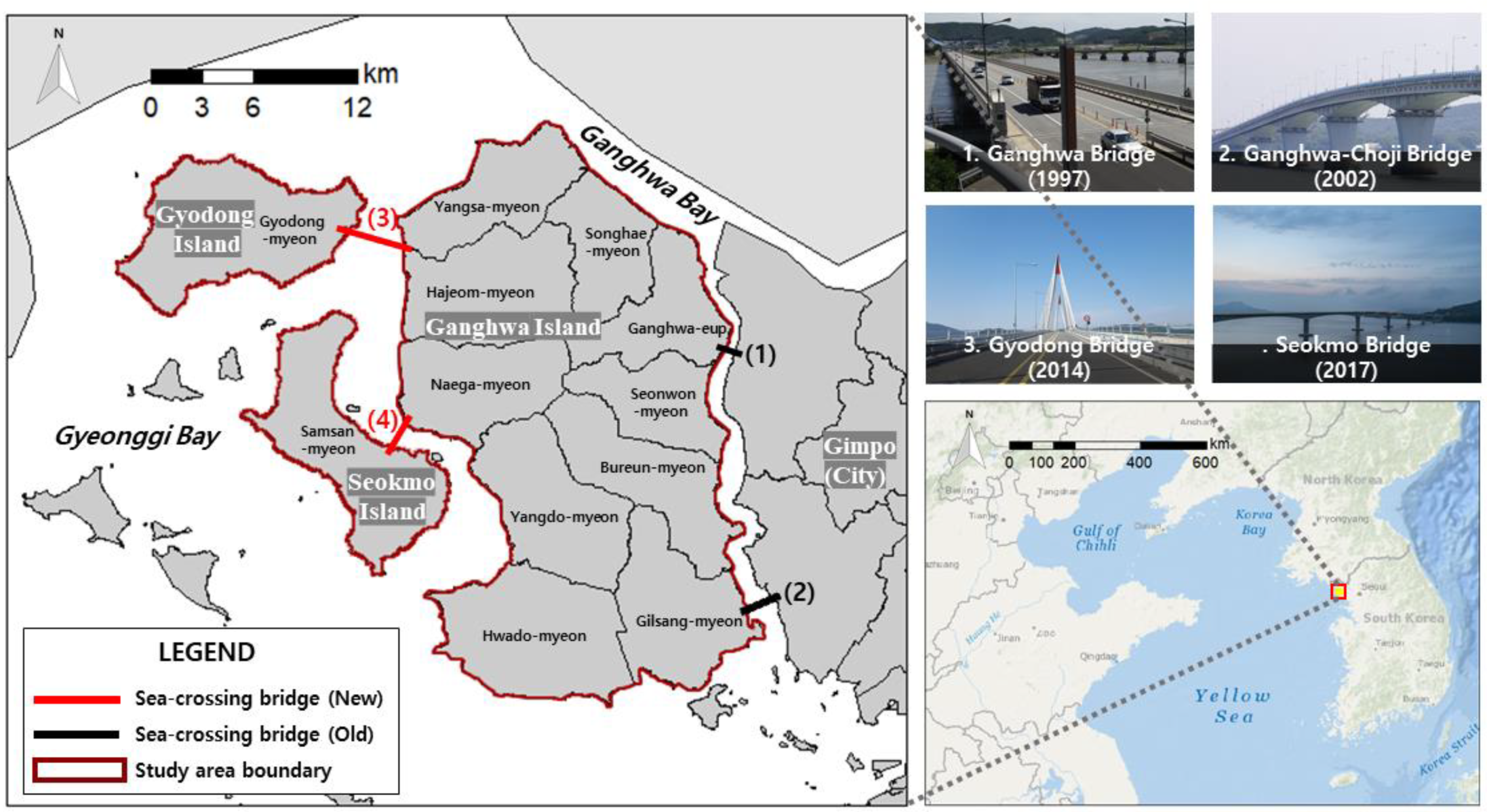
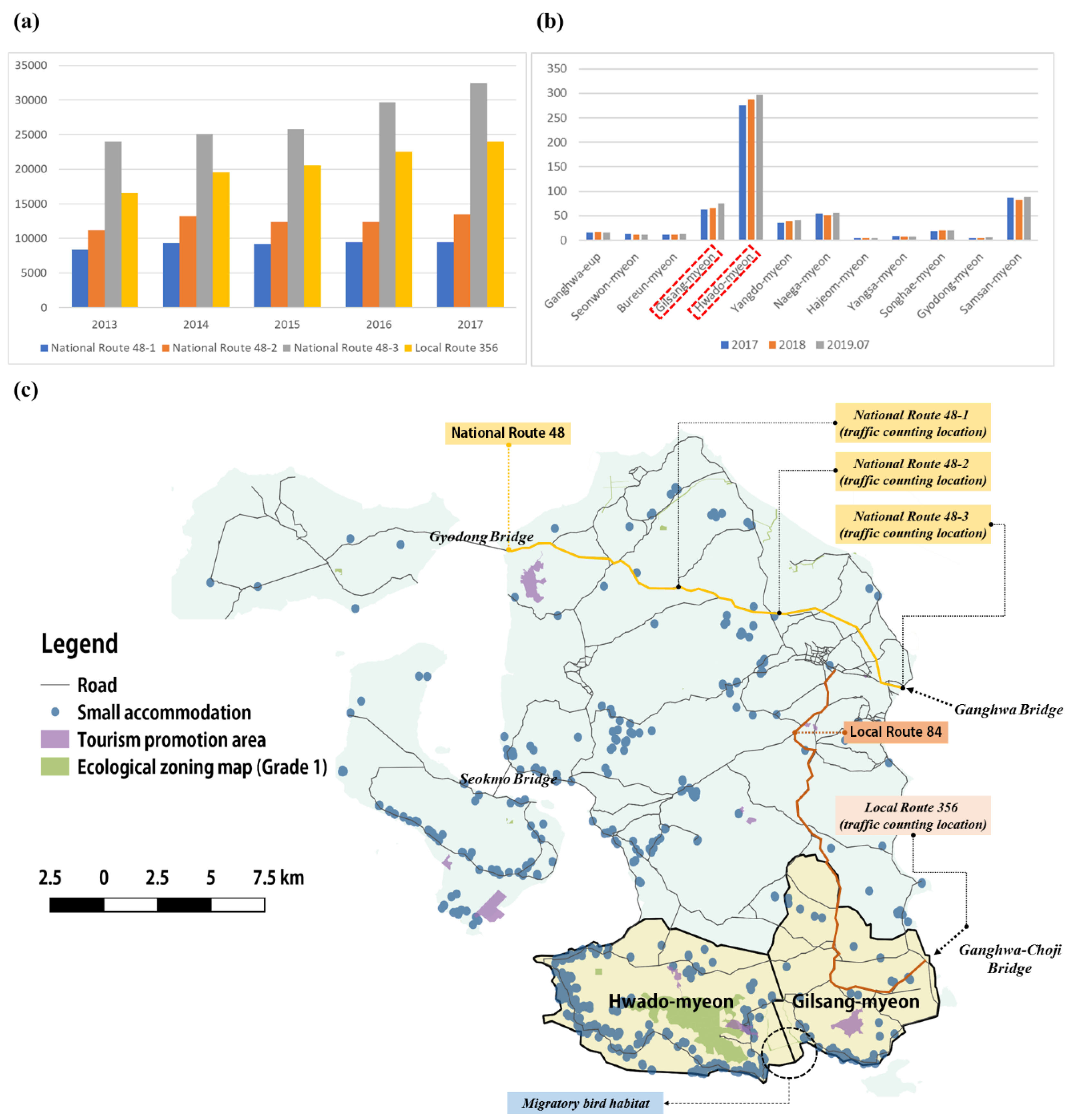
2.1. Study Area

Ganghwa County (Ganghwa Island, Seokmo Island and Gyodong Island) in Gyeonggi Bay in the Yellow Sea was chosen as the study area Figure 1. Ganghwa County is the main islands in the Yellow Sea and one of the most popular tourism destinations in South Korea, and it has an area of 411.4 km2 and a population of nearly 70,000 residents. Over 2 million tourists visited Ganghwa County in 2017 [22]. In addition, Ganghwa Island has been connected to the mainland and other islands by sea-crossing bridges for more than 20 years ago.
As shown in Figure 1, Ganghwa Island was connected to the mainland by Ganghwa Bridge (1) and Ganghwa-Choji Bridge (2) in 1997 and 2002, respectively, and since then, accessibility has improved in the metropolitan area. Ganghwa Island was also connected to Gyodong Island and Seokmo Island by Gyodong Bridge (3) and Seokmo Bridge (4) in 2014 and 2017, respectively. As a result of the bridges connecting these three islands, accessibility has increased, and thus traffic volume and the number of tourism facilities have been rapidly increasing in Ganghwa County.
According to Figure 2a, in terms of the average daily traffic volume of the National Route 48 and Local Route 356 in 2013, 60,103 vehicles passed across the road. In 2017, 79,358 vehicles passed across these routes [23]. Meanwhile, small accommodations (homestays and lodges) in Ganghwa County grew in number from 618 in July 2017 (after bridge connection) to 666 in July 2019, representing an increase of approximately 7.2% in those two years [24,25]. In particular, the small accommodations have increased over the past two years in Hwado-myeon and Gilsang-myeon around the southern region, see Figure 2b.
Hwado-myeon and Gilsang-myeon are areas adjacent to the Ganghwa southern mudflats and are rich in ecological resources, including migratory bird habitats, which are visited by many tourists. Due to its ecological significance, the Ganghwa southern mudflat area was designated as Korean Natural Monument No. 419. However, the landscape is being damaged and ecological resources are being threatened by the reckless construction of small accommodations around the Ganghwa southern mudflats, see Figure 2c.

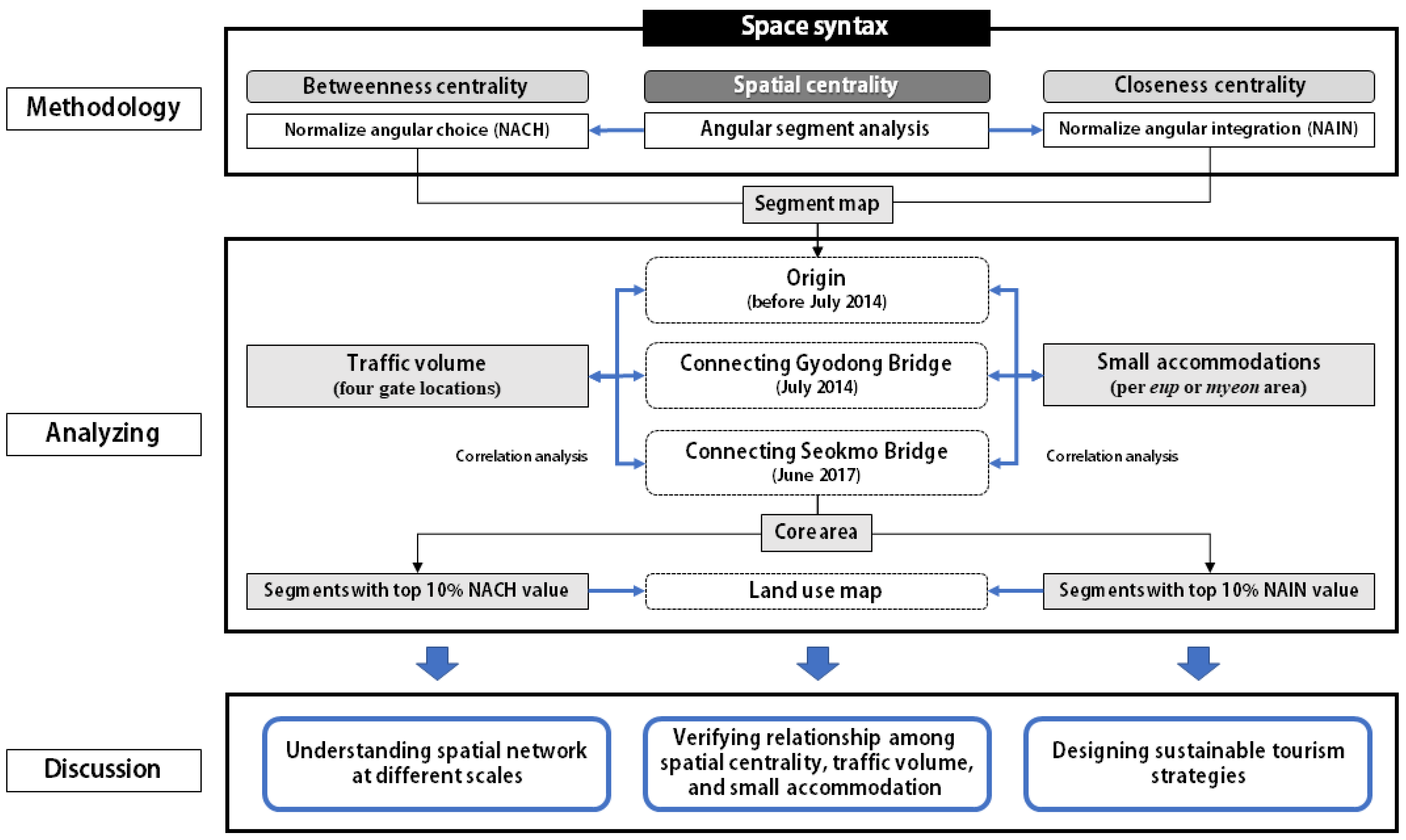
2.2. Research Questions and Analytical Framework

This study has taken a morphological approach that is able to calculate spatial centrality based on the understanding of spatial networks of the study area. This approach has been considered a useful way to measure movement, activity and behavior within spatial networks [19]. Therefore, in our study, spatial networks were analyzed over the time series to identify the spatial impact of bridge connections between islands when Ganghwa Island was connected to Gyodong Island (before and after July 2014, separately) and when all islands were connected by bridges (after June 2017). Furthermore, we verify if there is any significant spatial change at different scales. This study compared segment maps at different radii before and after the construction of these bridges, and the following research question (Q1) was established to identify the changes in spatial networks of the study area.
Q1. How can we identify the spatial change at different scales caused by bridge connections between islands through space syntax?
The construction of sea-crossing bridges between the islands has led to an increase in traffic flow and tourism facilities (especially small accommodations) in the study area. First, bridge connections between islands may increase in traffic volume in the study area. The higher the spatial centrality of street networks, the more vehicle traffic there is [26,27]. Next, the location of accommodations in local markets can have a significant impact on their operational performance because developers seek the best location for accommodations to minimize competition and maximize potential revenue as tourism demand increases in the area [28]. Finally, tourism demand can increase when many forms of accommodation are concentrated in an easily accessible location [29]. In this regard, we assumed that the traffic volume and accommodation are related to spatial centrality. This study used traffic volume and the number of small accommodations as indicators for verifying spatial centrality, and the research question (Q2) was established as follows:
Q2. Can we verify the correlations among spatial centrality, traffic volume and small accommodations on the islands?
Since the construction of the connecting bridges between islands, the term ‘core areas with high spatial centrality’ has been used to refer to areas where traffic volume and the number of tourists is more likely to increase. This increase can lead to negative ecosystem effects, including habitat destruction, if the traffic volume increase and tourism facilities continue to be built in conservation areas [30]. The top 10% of the most highly integrated spaces are those commonly referred to as core areas according to the space syntax glossary [31]. After identifying the top 10% in terms of their values for betweenness centrality and closeness centrality, another research question (Q3) is presented as follows:
Q3. How do we identify core areas for the high possibility of attracting tourists and design strategies to optimize core areas?
To respond to the abovementioned three research questions, we propose the following analytical framework, Figure 3.

2.3. Space Syntax Analysis

To understand the spatial change in the study area, we present the application of space syntax to identify spatial networks in Ganghwa County. The space syntax methodology is analyzed in spatial networks and can relate its characteristics to movement patterns and social activity. DepthmapX software (Space Syntax Limited, London, UK) is applied in this study to measure the spatial centrality of the study area. Spatial centrality, which refers to the accessibility of street networks, was intended to be measured by “betweenness centrality” and “closeness centrality” [32]. According to graph theory, betweenness centrality refers to the ability of a given node to control interactions between other pairs of nodes in the network while closeness centrality shows how closely a particular node is connected to other nodes in the network. Betweenness centrality is used to identify places that tourists frequently visit, and closeness centrality is used to identify places that tourists can easily access. For this study on Ganghwa County, spatial networks were simulated based on OpenStreetMap (OSM).
Then, we analyzed street networks in Ganghwa County using angular segment analysis (ASA) of space syntax. ASA, considering metric distance, contains two measures: “Choice” and “integration”. “Choice” and “integration” in space syntax terms correspond to the graph theory terms of “betweenness centrality” and “closeness centrality”, respectively. Hillier et al. [33] presented two normalized measures: Normalized angular choice (NACH) and normalized angular integration (NAIN). The street networks of Ganghwa County were analyzed using these measures. The NACH value captures the characteristic of serving as a critical intermediate between pairs of other areas and is calculated by counting the number of shortest paths to all road segments within a specific radius. The NAIN value reflects the characteristic of accessibility to other areas and is a measure of the accessibility of one road segment to all other road segments within a specific radius. When analyzing street networks based on a segment map, the radius can be defined with a metric measure. Previous studies found that the relationship between the type of spatial centrality and the traffic volume in urban areas may differ depending on the radius (scale) [34,35,36]. The street networks of Ganghwa County are calculated on several scales. The angular radii are defined as ranging from 500 m (local) to 12,000 m (global) on the basis of the size of Ganghwa County.

3. Results

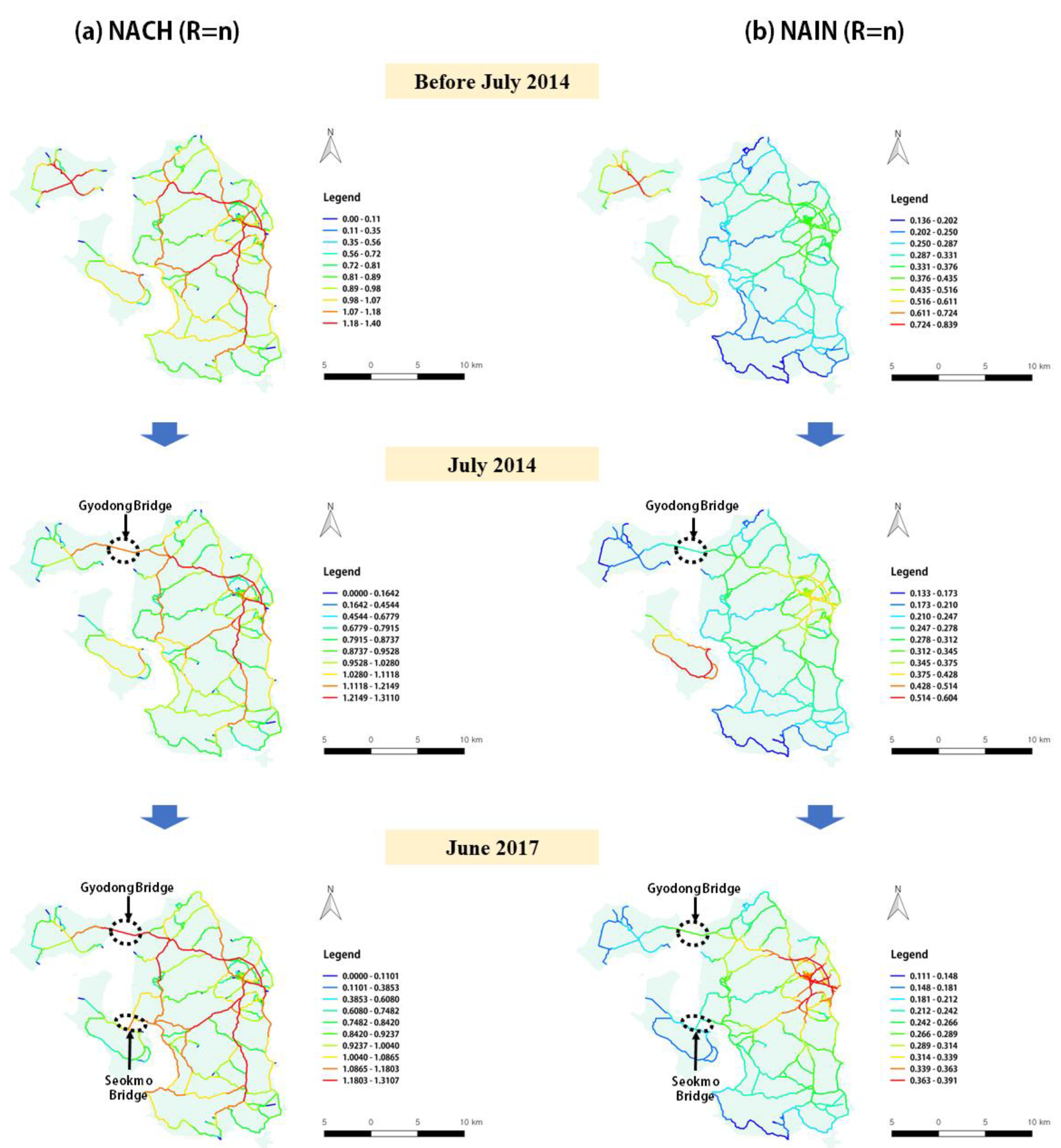
3.1. Analysis of the Spatial Centrality before and after Bridge Connection on a Global Scale

The spatial characteristics of the study area are shown in Figure 4 and Figure 5. Figure 4 shows the NACH and NAIN values on a global scale (R = n) before and after bridge construction. The closer the segments are to the red, the higher the values of NACH and NAIN on a global scale, while when they are closer to the blue, the NACH and NAIN values are lower. Figure 5 shows the segments of the core area based on the NAIN and NACH values before and after bridge connections. The core area refers to the segments that have the top 10% NAIN and NACH values on a global scale (R = n).
As shown in Figure 4a, segments with high NACH values are distributed around Ganghwa-eup and Gyodong-myeon on a global scale before July 2014, but the NACH value of Gyodong-myeon is slightly decreased after the bridge connection. This difference can be clearly seen in Figure 5a, where the segments of the top 10% of NACH values are reduced after the bridge connection. The segments in which the NACH values are higher in June 2017 than in the original situation are interpreted as areas where traffic flow is more likely to increase.
Figure 4b shows that prior to June 2017, Gyodong Island and Seokmo Island were areas with high NAIN values. In June 2017, although accessibility improved due to the construction of bridges between Ganghwa Island, Gyodong Island and Seokmo Island, the NAIN values decreased for Gyodong Island and Seokmo Island. However, the NAIN values for Ganghwa-eup have increased since the bridge connection. Figure 5b shows that the segments of core areas in Ganghwa County have been concentrated in Ganghwa-eup after the bridge connection. These findings show that as the closeness centrality of Ganghwa Island has gradually improved, the development potential around Ganghwa-eup has increased.

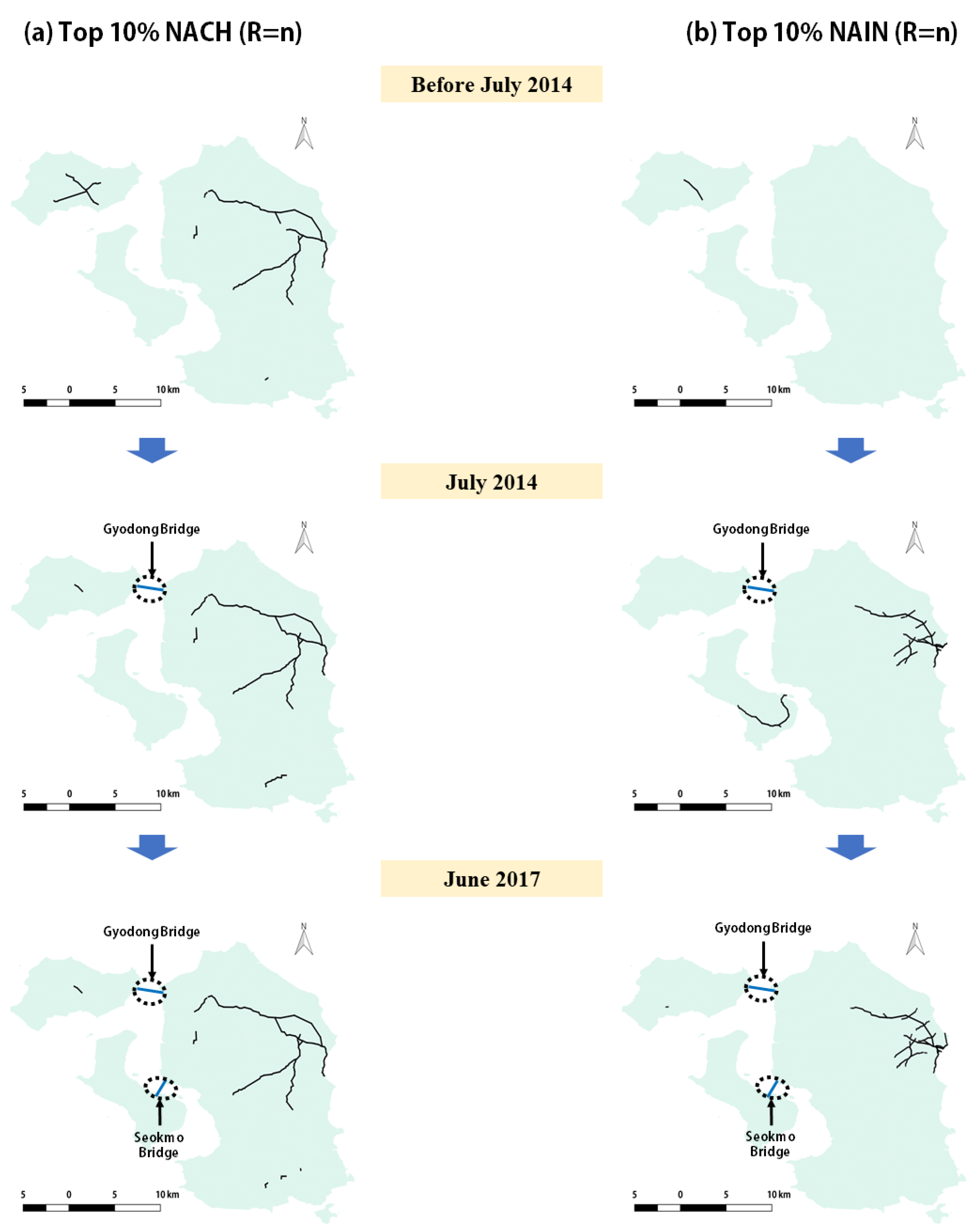
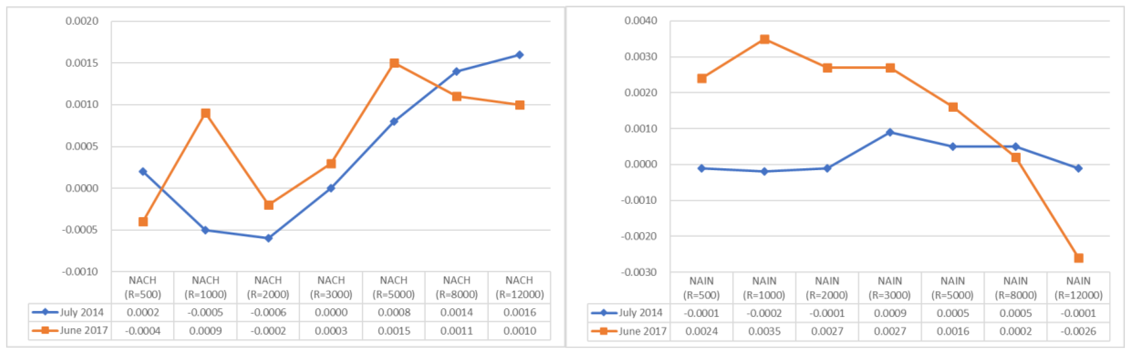
3.2. Analysis of the Spatial Centrality before and after Bridge Connections at Different Radii

Table 1 and Table 2 show the mean NACH and NAIN values extracted from street networks before and after bridge connection (Gyodong and Seokmo Bridges) on a local scale (500~1000 m), a mid-scale (2000~5000 m) and a global scale (more than 5000 m). This approach demonstrates how the bridge connection on an island changes street networks of the existing spatial structure and the difference between the mean NAIN and NACH values. In all these cases, the value of the original situation is deducted from the value after the bridge connection, see Figure 6.
The results show that the difference in the mean NACH values was increased with the increase in the angular radii at a mid-scale (R = 2000 m to R = 5000 m) after construction of Gyodong Bridge and Seokmo Bridge to connect the islands in Ganghwa County, while the mean NACH values decreased as they moved on a global scale (R = 8000 m). The difference in the NACH values after the Gyodong Bridge construction increased as they moved on a global scale. However, after the construction of the Seokmo Bridge, the difference in the mean NACH values decreased slightly. This result means that the difference in the mean NACH values after the construction of both the Gyodong Bridge and Seokmo Bridge decreased by over R = 8000 m.
In addition, the mean NAIN values show a pattern that is commonly maintained by the existing spatial networks since the bridge connections. The difference in the mean NAIN values at a mid-scale (R = 1000 m to R = 5000 m) after the construction of the Seokmo Bridge was slightly higher than that after the construction of the Gyodong Bridge, although negative values were found at R = 8000 m. That is, the mean NACH values decreased by a higher margin after the construction of the Seokmo Bridge. These results show that the bridge connections of islands can affect their spatial networks with an increase in the NACH and NAIN values, generally at a mid-scale, while they decreased significantly on a global scale.

3.3. Correlation Analysis among Spatial Centrality, Traffic Volume and Small Accommodations

To examine the relationship between spatial centrality and traffic volume in Ganghwa County, we analyzed the correlation between the NACH values on a local scale (R = 500 m) to global scale (R = 12,000 m) (four gate locations within the Ganghwa County) and traffic volume using Pearson’s correlation analysis Table 3. Before July 2014, the NACH values were not significantly correlated with traffic volume. However, the NACH values on a mid-scale (R = 3000 m) showed a significant correlation with the traffic volume, and its correlation coefficient was 0.980 (p ≤ 0.05) after July 2014 and 0.955 (p ≤ 0.05) after June 2017, see Table 3. This finding implies that the traffic volume and betweenness centrality were not correlated before July 2014 but were correlated on a mid-scale after July 2014. In short, this result implies that as the betweenness centrality on a mid-scale increases after the bridge connection, the traffic volume also increases.
To examine the relationship between spatial centrality and small accommodations in Ganghwa County, we analyzed the correlation between the NAIN values on a local scale (R = 500 m) to global scale (R = 12,000 m) and the number of small accommodations (per eup area or myeon area), see Table 4. Before July 2014, the NAIN values on a local scale (R = 500 m) were negatively related to small accommodations (−0.762, p ≤ 0.05). However, the NAIN values (R = 500 m) showed a significant correlation with small accommodations, with a correlation coefficient of 0.606 (p ≤ 0.05) after June 2017, see Table 4. The results show that there was a negative correlation between closeness centrality and small accommodations before July 2014 but a positive correlation after June 2017. More specifically, this finding means that the higher closeness centrality on a local scale led to a lower level of development of small accommodations before July 2014 and a higher level of development of small accommodations after June 2017.

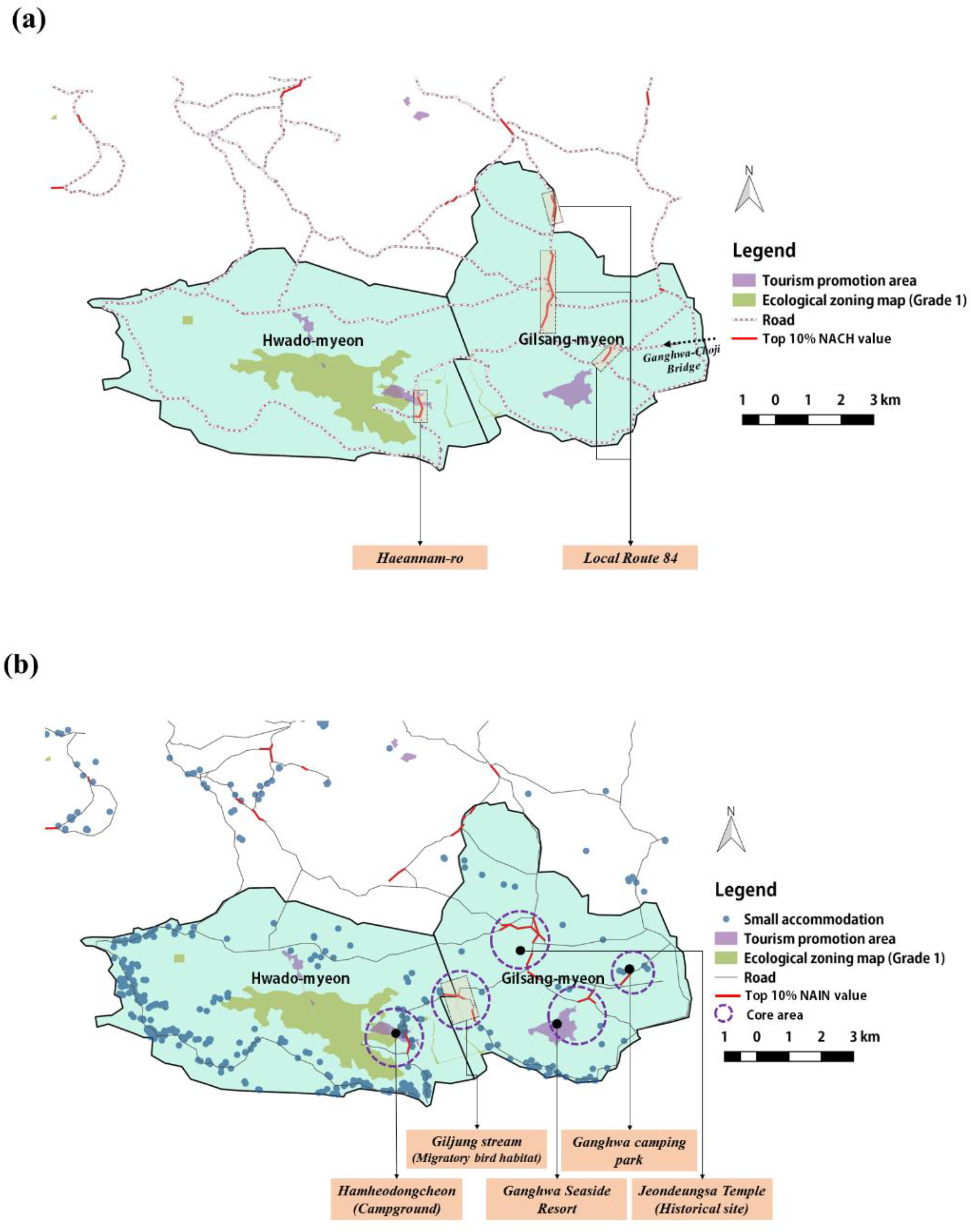
3.4. Analysis of the Core Areas after Bridge Connections between Islands

We selected areas where the NACH (R = 3000 m) and NAIN (R = 500 m) values in Hwado-myeon and Gilsang-myeon were in the top 10% of the total to identify those areas with a high possibility of increasing roads and small accommodations. We identified areas where the segments of the core area, conservation area (Grade 1 of ecological zoning map) and tourism promotion area overlap. The results concerning the spatial impact brought about by bridge connections on core areas in Ganghwa County using space syntax are presented in Figure 7.
Figure 7a shows the segments of the top 10% of the NACH values on a mid-scale (R = 3000 m) in Ganghwa County. The areas with high NACH values indicate areas with a high probability of increasing traffic volume and road extensions. On a mid-scale (R = 3000 m), the areas with the top 10% of NACH values can be explained as areas that many tourists pass through, including Haeannam-ro around the tourism promotion areas and Local Route 84. In particular, Local Route 84 is expected to experience an increase in traffic volume caused by tourists passing through via the Ganghwa-Choji Bridge.
Figure 7b shows the areas falling within the top 10% of the NAIN values (R = 500 m) for Ganghwa County. The areas with high NAIN values indicate areas with a high probability of tourism development including small accommodations. The areas with NAIN values in the top 10% on a local scale (R = 500 m) are as follows: Hamheodongcheon (campground), Jeondeungsa Temple (historical site), Ganghwa seaside resort, Ganghwa camping park and the core areas around the Giljung stream (habitats of migratory birds). In particular, the core areas around the Giljung stream are expected to have damaged migratory bird habitats and to increase in small accommodations.

4. Discussion

4.1. Understanding the Impact of Spatial Change by Bridge Connections between Islands

The connection between the mainland and island by sea-crossing bridges causes strong development pressures, such as changes in land use and an increase in tourists [5]. In our study, interestingly, we found the process of island urbanization along with bridge connections between islands. The space syntax results show that the bridge connections between islands change their spatial networks and a positive relationship occurs between spatial centrality and urbanization. Given the increase in the NAIN values of Ganghwa-eup after the bridge connection compared to those before the bridge connection, it is expected that urban growth will accelerate in Ganghwa-eup.
These changes can be explained as a “movement economies” process, in which the rapid urbanization of an island results in the differentiation of land use in the center and surrounding areas [37]. Hillier argues for the “natural movement” theory, which states that urban movement patterns are influenced by spatial configuration [26], and suggests that urban movement patterns are created and affect land use choices as they adapt to more intensive development. In other words, it results from prediction that tourism development will be concentrated in an accessible space for people, capital and goods in an island’s urbanization process.
In addition, an increase in the traffic flow on an island is recognized as a common effect of the construction of sea-crossing bridges [38,39]. This increased traffic flow affects both the growth of tourism revenue and total number of tourists. However, the improved accessibility of the island could ironically lead to the outflow of residents. In our study, Ganghwa Island was connected to Seokmo Island and Gyodong Island, the NACH values of Ganghwa Island increased, while the NACH values of Seokmo Island and Gyodong Island decreased. These findings imply that the possibility of movement on the Ganghwa Island will increase after connecting the bridges. On the other hand, mobility on Seokmo Island and Gyodong Island was predicted to decrease with decreases in the betweenness centrality. These results relate to the fact that bridge connections on islands can result in a decrease in residents [10]. The bridge connection between islands could lead to enhanced accessibility to the mainland for residents, which could lead to more active exports and imports to land or more relocation to cities. In this view, the residents of Seokmo and Gyodong will often pass through Ganghwa Island to move to the mainland. The island could experience decreased tourists if its novelty is damaged by bridge connections [10]. Therefore, Seokmo Island and Gyodong Island can reduce the possibility of movement by bridge connection.

4.2. Understanding Spatial Networks of Ganghwa County at Different Scales

ASA applied by metric distance has been developed to help predict the core area of movement in street networks [40]. In our study, we analyzed how street networks of Ganghwa County changes from the local scale to global scale after the bridge connection. As a result, the trend of mean NACH values of Ganghwa County showed differences for the 500 m radius and 12,000 m radius between July 2014 and June 2017. In particular, the mean NACH values at a 500 m radius after the construction of the connecting Seokmo Bridge (June 2017) was lower than that before the bridge connection. Assuming that a 400 m radius is the walkable distance in five minutes, these results indicate that the locality of the island would be weakened by the bridge connection. These results are related to the process in which residents migrate to the mainland or another island and the island’s community collapses [10].
On global scales (more than 5000 m), the mean NAIN and NACH values after connecting all bridges were lower than the mean NAIN and NACH values at the connection of Gyodong Bridge. In other words, on the global scale, the level of impact on the spatial centrality was highest when Gyodong Island connects to Ganghwa Island by Gyodong Bridge. Figure 4 indicates that this high impact happens because the spatial centrality of Ganghwa-eup has been strengthened after the connection of all bridges in 2017. The rapid urbanization of Ganghwa-eup refers to the decline of other regions. Bridge connections between islands can facilitate migration to relatively large islands and accelerate urbanization [41].

4.3. Verifying the Relationships among Spatial Centrality, Traffic Volume and Small Accommodations

Previous studies that have used space syntax to verify the correlation between the spatial configuration and traffic flow suggest that integration is a major factor in determining the movement pattern [26,27]. The choice value in a segment map refers to the possibility of movement in street networks [42]. In our study, we analyzed how the change in the spatial centrality of street networks due to the bridge connection on the island is related to the traffic volume. As a result, NACH values at all scales before the bridge connection were not correlated with vehicle traffic, and the NACH (R = 3000 m) values after the bridge connection verified the correlation.
In the Ganghwa County study, the entry of visitors to the island is likely to lead to investments in island property and gradual increases in real estate prices. “Island gentrification” can lead to residents being turned away [43]. In South Korea, small accommodations are supposed to be managed by farmers or fishers who are residents to increase their income, although such accommodations have become a serious issue as outsiders move down to the rural areas and build small accommodations as a means of investment. In this context, small accommodations are being built in areas with a high level of spatial centrality in Ganghwa County. In our study, the correlation coefficient between NAIN (R = 500 m) values and the number of small accommodation facilities showed negative values (−0.762, p ≤ 0.05) before the bridge connection but positive values (0.606, p ≤ 0.05) after the bridge connection. In other words, this result showed that the area with a high closeness centrality had few small accommodations before connecting the bridge, but after connecting the bridges, the number of small accommodations in the area increased. On a local scale, the closeness centrality can be identified as a variable that determines the concentration of small accommodations on the island.

4.4. Sustainable Tourism Strategies for Islands Connected by Bridges

The connection between the mainland and island by sea-crossing bridges causes strong development pressures, such as changes in land use and an increase in tourists [5]. This study also shows the possibility that bridge connections between islands can further promote these processes. In particular, the change in tourism and traffic is one of the island’s “bridge effects” [8]. This concept can be used as a basis for the islands to establish a tourism management strategy. Therefore, we select the core areas of the island after bridge connection and establish strategies for sustainable tourism within tourism destinations of Hwado-myeon and Gilsang-myeon.
The core areas with a high betweenness centrality on the entire street network are expected to be congested with traffic as the segments with a high possibility of movement for tourists. Traffic congestion in tourism destinations is related to the concentration of tourists [44]. Therefore, a plan is required to disperse tourists across areas such as Haeannam-ro and ‘Local Route 84′ where a high frequency of visits is predicted. Traffic congestion can damage the images of tourism destinations [45], and can have a negative impact on island tourism. In this view, we suggest a plan to alleviate the phenomenon of an imbalance in tourists visiting certain tourist sites by designing new touring routes. Today, tourist visits commonly take the pattern of multi-destination travel, in which tourists visit a number of tourism destinations in one trip [46,47]. On a regional scale, this plan can provide tourists with opportunities for new attractions and provide them with a chance for balanced regional development by exploring diverse local resources and developing them into ecotourism resources. In addition, during peak season, shuttle buses can be worked in tourism destinations to control congestion levels. This strategy can take advantage of attracting tourists while considering the environmental impact of traffic congestion [48].
In core areas, which present high closeness centrality over the entire street network, small accommodations are expected because these areas are the segments with a high possibility of concentrating tourists. In our study, considering the environmental impact of the bridge connection between islands, a plan for distributing land use regulation is suggested. In the vicinity of habitat areas with high closeness centrality, such as the Giljung stream, land use regulations should be strengthened to curb the increase in the number of small accommodations. Such a plan is necessary because if the number of small accommodations increases around habitat areas with good scenery, the reduction in the ecological resources can decrease tourism attractiveness. Moreover, if tourists are excessively concentrated around habitat areas, the attractiveness of ecological resources may be damaged. To manage this problem, it is possible to develop educational programs as responsible tourism in habitat areas to contribute to the formation of values that support environmental conservation. If tourism activities are carried out by tourists who value environmental conservation, the possibility of damage to habitats can decrease and the attractiveness of ecological resources will increase [49].
On the other hand, for core areas with high closeness centrality such as Hamheodongcheon, the Ganghwa camping park and the Ganghwa seaside resort, land use plans should be established to encourage tourist complexes with accommodations by easing regulations on land use. If land use regulations are tightened in the urban core areas, the carrying capacity of accommodation may decrease as the investment in tourism facilities decreases. In this view, the land use plan of tourism destinations should be applied differently depending on the spatial centrality and the functions required by each location in the islands.

5. Conclusions

This paper has verified how the construction of bridges connecting islands impacts island tourism destinations through spatial change. In our study, space syntax was applied to quantitatively identify how spatial networks of Ganghwa County changed before and after its islands were connected by sea-crossing bridges. Then, the results of space syntax were superimposed on the land use map to demonstrate the spatial characteristics of Ganghwa County. Finally, policy alternatives were proposed for the sustainable management of islands connected by sea-crossing bridges. The key findings of this study are as follows.
First, bridge connections between islands facilitate island urbanization. We clarify the differences in the spatial centrality of Ganghwa County that emerged before July 2014 and after June 2017 when the Gyodong and Seokmo Bridges were constructed. The “landization” by bridge connections between islands causes very large changes in spatial centrality. When the bridge connection between islands is completed, the spatial centrality shifts to relatively large and developed islands [41]. For example, if islands are connected, the density of the population in developed islands could increase as residents move to the developed island. Moreover, the investment of outsiders can encourage the hollowization of islands by rising real estate prices. In our study, the spatial centrality of Ganghwa Island adjacent to the mainland was higher than that of Seokmodo-do and Gyodong-do, which are newly connected by bridges, thus supporting the finding of hollowization.
Second, bridge connections between islands could lead to ‘limits to growth’ if the islands’ dependence on tourism excessively increases. The results of this study have shown that reckless tourism development may cause uncertainty in carrying capacity over time; therefore, alternatives for mitigating drastic changes should be proactively applied. We suggest the promotion of alternative paths for tourist flow diffusion, land use regulation and damage mitigation based on the location type and providing environmental education for responsible tourism that represents key strategies for sustainable tourism. Thus, we identified core areas with a high probability of development and divided protection and development zones according to their land use type. Thus, although recognizing that mass tourism can have a negative impact on natural resources [44], it should be reasonably accommodated by considering the potential demand. Thus, the local government can restrict reckless development through land use regulations on conservation areas and develop tourism complexes by integrating tourist facilities in tourism promotion areas. In addition, software-based approaches, such as environmental education for tourists and the promotion of alternative courses, can also mitigate the negative impact of tourist concentration.
This study has both methodological and empirical implications. In terms of methodological implications, this study implements the ASA by metric distance based on space syntax. Many studies have used space syntax as an approach for analyzing spatial structure through space syntax indicators, although limitations in measuring spatial centrality within various metric distances were observed. This study is meaningful in that the limitations of space syntax have been overcome through the use of ASA. In terms of the empirical implications of this study, we contribute to reducing the potential for environmental damage by providing practical strategies for those islands connected by bridges. For example, practitioners can establish sustainable management strategies for islands, such as establishing environmental education centers in areas where tourists are likely to be concentrated or installing more attractive tourist offerings in areas where tourist concentration is low.
This study can be recognized as a case study of a group of islands connected by bridges that suggests policies for maintaining balance between tourism development and natural resource conservation. However, islands connected by bridges can be described as being of various morphological types. Thus, further empirical studies using space syntax are required to confirm the external validity of this work.

Author Contributions

Conceptualization, D.J.; Data curation, L.J.; Formal analysis, D.J.; Investigation, D.J. and Y.E.C.; Methodology, D.J. and Y.E.C.; Validation, D.J.; Visualization, D.J. and L.J.; Writing—original draft, D.J.; Writing—review & editing, Y.E.C., L.J. and J.C.; Project administration, Supervision, and Funding acquisition, J.C.

Funding

This research was supported by the Korea Environment Industry & Technology Institute (KEITI) grant (No. 2018000210006) funded by Ministry of Environment (MOE).

Conflicts of Interest

The authors declare no conflict of interest.

References

  1. Baldacchino, G. The lure of the island: A spatial analysis of power relations. J. Mar. Isl. Cult. 2012, 1, 55–62. [Google Scholar] [CrossRef]
  2. Pan, Y.; Zhai, M.; Lin, L.; Lin, Y.; Cai, J.; Deng, J.-S.; Wang, K. Characterizing the spatiotemporal evolutions and impact of rapid urbanization on island sustainable development. Habitat Int. 2016, 53, 215–227. [Google Scholar] [CrossRef]
  3. Tzanopoulos, J.; Vogiatzakis, I.N. Processes and patterns of landscape change on a small Aegean island: The case of Sifnos, Greece. Landsc. Urban Plan. 2011, 99, 58–64. [Google Scholar] [CrossRef]
  4. Patarasuk, R.; Binford, M.W. Longitudinal analysis of the road network development and land-cover change in Lop Buri province, Thailand, 1989–2006. Appl. Geogr. 2012, 32, 228–239. [Google Scholar] [CrossRef]
  5. Xie, Z.; Li, X.; Zhang, Y.; Chen, S. Accelerated expansion of built-up area after bridge connection with mainland: A case study of Zhujiajian Island. Ocean Coast. Manag. 2018, 152, 62–69. [Google Scholar] [CrossRef]
  6. Chen, J.; Ye, G.; Jing, C.; Wu, J.; Ma, P. Ecological footprint analysis on tourism carrying capacity at the Zhoushan Archipelago, China. Asia Pac. J. Tour. Res. 2017, 22, 1049–1062. [Google Scholar] [CrossRef]
  7. Sun, B.; Ma, X.; de Jong, M.; Bao, X. Assessment on Island Ecological Vulnerability to Urbanization: A Tale of Chongming Island, China. Sustainability 2019, 11, 2536. [Google Scholar] [CrossRef]
  8. Baldacchino, G.; MacDonald, E.; Spears, A. Bridging Islands: The Impact of Fixed Links; Acorn Press: Charlottetown, PE, Canada, 2007. [Google Scholar]
  9. Yang, J.; Ge, Y.; Ge, Q.; Xi, J.; Li, X. Determinants of island tourism development: The example of Dachangshan Island. Tour. Manag. 2016, 55, 261–271. [Google Scholar] [CrossRef]
  10. Baldacchino, G. Fixed links and the engagement of islandness: Reviewing the impact of the Confederation Bridge. Can. Geogr. 2007, 51, 323–336. [Google Scholar] [CrossRef]
  11. Mai, T.; Smith, C. Addressing the threats to tourism sustainability using systems thinking: A case study of Cat Ba Island, Vietnam. J. Sustain. Tour. 2015, 23, 1504–1528. [Google Scholar] [CrossRef]
  12. Rodríguez, J.R.O.; Parra-López, E.; Yanes-Estévez, V. The sustainability of island destinations: Tourism area life cycle and teleological perspectives. The case of Tenerife. Tour. Manag. 2008, 29, 53–65. [Google Scholar] [CrossRef]
  13. Baldacchino, G.; Spears, A. The Bridge Effect: A Tentative Score Sheet for Prince Edward Island; Acorn Press: Charlottetown, PE, Canada, 2007. [Google Scholar]
  14. Evans, D.; Eng, P.; Thompson, B. ENVIRONMENTAL MANAGEMENT OF AGED BRIDGE STRUCTURES IN PEI. In Proceedings of the Transportation Factor 2003, Annual Conference and Exhibition of the Transportation Association of Canada (Congres et Exposition Annuels de l’Association des Transport du Canada), St. John’s, NL, Canada, 21–24 September 2003. [Google Scholar]
  15. McQuaid, R.W.; Greig, M. The bridge to Skye, Scotland. In Bridging Islands: The Impact of Fixed Links; Acorn Press: Charlottetown, PE, Canada, 2007; pp. 189–206. [Google Scholar]
  16. Cottrell, J.R.; Cottrell, S.P. Sense of place predictors of perceived effects of a proposed island to mainland bridge on future experience. Isl. Stud. J. 2019, 14, 187–204. [Google Scholar]
  17. McElroy, J.L. A world of islands: An island studies reader. Geogr. Rev. 2007, 97, 304–306. [Google Scholar]
  18. Li, Y.; Xiao, L.; Ye, Y.; Xu, W.; Law, A. Understanding tourist space at a historic site through space syntax analysis: The case of Gulangyu, China. Tour. Manag. 2016, 52, 30–43. [Google Scholar] [CrossRef]
  19. Karimi, K. A configurational approach to analytical urban design: ‘Space syntax’ methodology. Urban Des. Int. 2012, 17, 297–318. [Google Scholar] [CrossRef]
  20. Bafna, S. Space syntax: A brief introduction to its logic and analytical techniques. Environ. Behav. 2003, 35, 17–29. [Google Scholar] [CrossRef]
  21. Hillier, B.; Hanson, J. The Social Logic of Space; Cambridge University Press: Cambridge, UK; London, UK, 1989. [Google Scholar]
  22. Ganghwa County Basic Statistics 2018. Available online: http://www.ganghwa.go.kr/open_content/main/bbs/bbsMsgFileDown.do?bcd=datastats&msg_seq=13&fileno=3 (accessed on 14 June 2019).
  23. Traffic Monitoring System. Available online: http://www.road.re.kr/itms/itms_01_1.asp (accessed on 1 July 2019).
  24. Homestay Statistics in Ganghwa County 2017. Available online: https://www.ganghwa.go.kr/open_content/main/bbs/bbsMsgFileDown.do?bcd=opendata&msg_seq=2091&fileno=1 (accessed on 12 September 2019).
  25. Homestay Statistics in Ganghwa County 2019. Available online: https://www.ganghwa.go.kr/open_content/main/bbs/bbsMsgFileDown.do?bcd=opendata&msg_seq=3412&fileno=1 (accessed on 12 September 2019).
  26. Hillier, B.; Penn, A.; Hanson, J.; Grajewski, T.; Xu, J. Natural movement: Or, configuration and attraction in urban pedestrian movement. Environ. Plan. B Plan. Des. 1993, 20, 29–66. [Google Scholar] [CrossRef]
  27. Penn, A.; Hillier, B.; Banister, D.; Xu, J. Configurational modelling of urban movement networks. Environ. Plan. B Plan. Des. 1998, 25, 59–84. [Google Scholar] [CrossRef]
  28. Baum, J.A.; Haveman, H.A. Love thy neighbor? Differentiation and agglomeration in the Manhattan hotel industry, 1898–1990. Adm. Sci. Q. 1997, 42, 304–338. [Google Scholar] [CrossRef]
  29. Chung, W.; Kalnins, A. Agglomeration effects and performance: A test of the Texas lodging industry. Strateg. Manag. J. 2001, 22, 969–988. [Google Scholar] [CrossRef]
  30. Choi, Y.; Song, K.; Kim, M.; Lee, J. Transformation planning for resilient wildlife habitats in ecotourism systems. Sustainability 2017, 9, 487. [Google Scholar] [CrossRef]
  31. Klarqvist, B. A space syntax glossary. Nordisk Arkitekturforskning 1993, 2, 11–12. [Google Scholar]
  32. Hillier, B.; Iida, S. Network and psychological effects in urban movement. In Proceedings of the International Conference on Spatial Information Theory, Heidelberg/Berlin, Germany, 14–18 September 2005; pp. 475–490. [Google Scholar]
  33. Hillier, W.; Yang, T.; Turner, A. Normalising least angle choice in Depthmap-and how it opens up new perspectives on the global and local analysis of city space. J. Space Syntax 2012, 3, 155–193. [Google Scholar]
  34. Jiang, B.; Liu, C. Street-based topological representations and analyses for predicting traffic flow in GIS. Int. J. Geogr. Inf. Sci. 2009, 23, 1119–1137. [Google Scholar] [CrossRef]
  35. Omer, I.; Jiang, B. Can cognitive inferences be made from aggregate traffic flow data? Comput. Environ. Urban Syst. 2015, 54, 219–229. [Google Scholar] [CrossRef]
  36. Pont, M.B.; Marcus, L. What can typology explain that configuration cannot. In Proceedings of the SSS10 10th International Space Syntax Symposium, London, UK, 13–17 July 2015. [Google Scholar]
  37. Hillier, B. Cities as movement economies. Urban Des. Int. 1996, 1, 41–60. [Google Scholar] [CrossRef]
  38. Knowles, R. 12 Fixed Links and Short Sea Crossings. In Cityports, Coastal Zones and Regional Change: International Perspectives on Planning and Management; Wiley: Hoboken, NJ, USA, 1996; p. 213. [Google Scholar]
  39. Matthiessen, C.W. The Öresund Area: Pre-and post-bridge cross-border functional integration: The bi-national regional question. GeoJournal 2004, 61, 31–39. [Google Scholar] [CrossRef]
  40. Turner, A. From axial to road-centre lines: A new representation for space syntax and a new model of route choice for transport network analysis. Environ. Plan. B Plan. Des. 2007, 34, 539–555. [Google Scholar] [CrossRef]
  41. Yue, W.; Qiu, S.; Zhang, H.; Qi, J. Migratory patterns and population redistribution in China’s Zhoushan Archipelago in the context of rapid urbanization. Isl. Stud. J. 2017, 12. [Google Scholar] [CrossRef]
  42. Serra, M.; Hillier, B. Spatial configuration and vehicular movement. In Proceedings of the 11th Space Syntax Symposium, Lisbon, Portugal, 3–7 July 2017. [Google Scholar]
  43. Clark, E.; Johnson, K.; Lundholm, E.; Malmberg, G. Island gentrification and space wars. In A World of Islands: An Island Studies Reader; Island Studies Press: Charlottetown, PE, Canada, 2007; pp. 481–510. [Google Scholar]
  44. Saenz-de-Miera, O.; Rosselló, J. The responsibility of tourism in traffic congestion and hyper-congestion: A case study from Mallorca, Spain. Tour. Manag. 2012, 33, 466–479. [Google Scholar] [CrossRef]
  45. Cui, X.; Ryan, C. Perceptions of place, modernity and the impacts of tourism–Differences among rural and urban residents of Ankang, China: A likelihood ratio analysis. Tour. Manag. 2011, 32, 604–615. [Google Scholar] [CrossRef]
  46. Lue, C.-C.; Crompton, J.L.; Fesenmaier, D.R. Conceptualization of multi-destination pleasure trips. Ann. Tour. Res. 1993, 20, 289–301. [Google Scholar] [CrossRef]
  47. de Oliveira Santos, G.E.; Ramos, V.; Rey-Maquieira, J. Determinants of multi-destination tourism trips in Brazil. Tour. Econ. 2012, 18, 1331–1349. [Google Scholar] [CrossRef]
  48. Weaver, D.B. Ecotourism as mass tourism: Contradiction or reality? Cornell Hotel Restaur. Adm. Q. 2001, 42, 104–112. [Google Scholar] [CrossRef]
  49. Choi, Y.; Doh, M.; Park, S.; Chon, J. Transformation planning of ecotourism systems to invigorate responsible tourism. Sustainability 2017, 9, 2248. [Google Scholar] [CrossRef] [Green Version]
Figure 1. Geographical location of Ganghwa County.
Sustainability 11 06516 g001
Figure 2. (a) A traffic volume of four gate locations and (b) the number of small accommodations in Ganghwa County. (c) The distribution of small accommodations and the land use of Ganghwa County.
Sustainability 11 06516 g002
Figure 3. Analytical framework of this study.
Sustainability 11 06516 g003
Figure 4. Segments of normalized angular choice (NACH) and normalized angular integration (NAIN) values on a global scale (R = n).
Sustainability 11 06516 g004
Figure 5. Segments of the top 10% of NACH and NAIN values on a global scale (R = n) (black line).
Sustainability 11 06516 g005
Figure 6. Differences in the mean NACH (left) and mean NAIN (right) values from a local to global scale.
Sustainability 11 06516 g006
Figure 7. Segments of the top 10% of NACH (R = 500 m) (a) and NAIN values (R = 3000 m) (b).
Sustainability 11 06516 g007
Table 1. Mean NACH values of street networks calculated using different radii.
Mean NACH (Radii)Origin (before July 2014)Connecting Gyodong Bridge (July 2014)Connecting Seokmo Bridge (June 2017)
NACH (R = 500 m)0.46790.46810.4675
NACH (R = 1000 m)0.83520.83470.8361
NACH (R = 2000 m)1.02581.02521.0256
NACH (R = 3000 m)1.04811.04811.0484
NACH (R = 5000 m)1.03921.041.0407
NACH (R = 8000 m)1.01481.01621.0159
NACH (R = 12,000 m)0.99320.99480.9942
NACH (R = n)0.91330.90810.9122
Table 2. Mean NAIN values of street networks calculated using different radii.
Mean NAIN (Radii)Origin (before July 2014)Connecting Gyodong Bridge (July 2014)Connecting Seokmo Bridge (June 2017)
NAIN (R = 500 m)1.40171.40161.4041
NAIN (R = 1000 m)1.39591.39571.3994
NAIN (R = 2000 m)1.13671.13661.1394
NAIN (R = 3000 m)0.93030.93120.933
NAIN (R = 5000 m)0.71180.71230.7134
NAIN (R = 8000 m)0.56590.56640.5661
NAIN (R = 12,000 m)0.4790.47890.4764
NAIN (R = n)0.320.2930.2735
Table 3. Correlation between NACH values and traffic volume (four gate locations).
YearCorrelation Coefficient (r)
Origin (before July 2014)0.427
Connecting Gyodong Bridge (July 2014)0.980 *
Connecting Seokmo Bridge (June 2017)0.955 *
Note: * p ≤ 0.05, two-tailed.
Table 4. Correlation between the mean NAIN values and number of small accommodations.
YearCorrelation Coefficient (r)
Origin (before July 2014)−0.762 *
Connecting Gyodong Bridge (July 2014)0.394
Connecting Seokmo Bridge (June 2017)0.606 *
Note: * p ≤ 0.05, two-tailed.

