Integrating UAV Technology in an Ecological Monitoring System for Community Wildlife Management Areas in Tanzania

Abstract
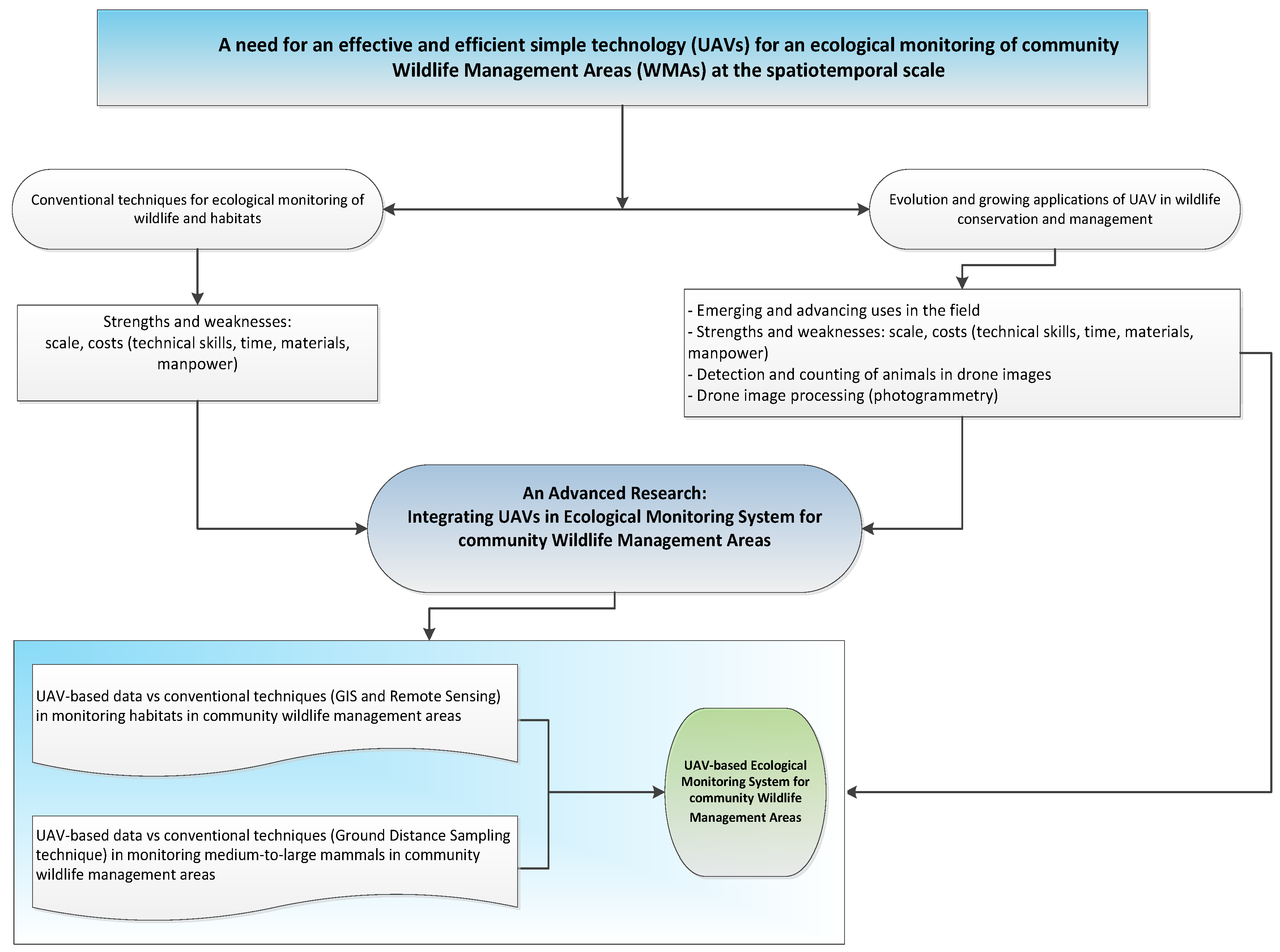
1. Introduction
2. Conventional Techniques for Ecological Monitoring of Wildlife and Their Habitats
3. UAV-Based Assessment of Animals and Their Habitats
4. A Need for an Integrated UAV-Based Ecological Monitoring System
5. Relevance of UAV Technology in Ecological Monitoring of Small Community Wildlife Management Areas
6. Challenges Associated with the Use of UAV in Conservation
6.1. Legal and Ethical Requirements
“If ecologists hope to realize the potential for advances in aerial imagery, population and community ecology, and large-scale conservation that can result from using UAV technologies, we have to advocate for lower barriers to entry so UAVs may become part of the ecologist’s “toolbox”. The status quo of governmental regulation of UAV-driven research requires effort and time beyond what is realistic for practitioners who wish to use the UAVs as an additional element of a research program”.
6.2. Technical Challenges
6.3. Weather Conditions
7. Conclusions
Author Contributions
Funding
Acknowledgments
Conflicts of Interest
References
- Bregoli, F.; Crosato, A.; Paron, P.; McClain, M. Humans reshape wetlands: Unveiling the last 100 years of morphological changes of the Mara Wetland, Tanzania. Sci. Total Environ. 2019, 691, 896–907. [Google Scholar] [CrossRef] [PubMed]
- Brunton, E.; Bolin, J.; Leon, J.; Burnett, S. Fright or Flight? Behavioural Responses of Kangaroos to Drone-Based Monitoring. Drones 2019, 3, 41. [Google Scholar] [CrossRef]
- Chabot, D.; Bird, D.M. Wildlife research and management methods in the 21st century: Where do unmanned aircraft fit in? J. Unmanned Veh. Syst. 2015, 3, 137–155. [Google Scholar] [CrossRef]
- Chrétien, L.P.; Théau, J.; Ménard, P. Visible and thermal infrared remote sensing for the detection of white-tailed deer using an unmanned aerial system. Wildl. Soc. Bull. 2016, 40, 181–191. [Google Scholar] [CrossRef]
- Colefax, A.P.; Butcher, P.A.; Pagendam, D.E.; Kelaher, B.P. Reliability of marine faunal detections in drone-based monitoring. Ocean Coast. Manag. 2019, 174, 108–115. [Google Scholar] [CrossRef]
- Lahoz-Monfort, J.J.; Tingley, R. The technology revolution: improving species detection and monitoring using new tools and statistical methods. In Monitoring Threatened Species and Ecological Communities; CSIRO Publishing: Melbourne, Australia, 2018; pp. 303–316. [Google Scholar]
- Hodgson, A.; Peel, D.; Kelly, N. Unmanned aerial vehicles for surveying marine fauna: Assessing detection probability. Ecol. Appl. 2017, 27, 1253–1267. [Google Scholar] [CrossRef]
- Hambrecht, L.; Brown, R.P.; Piel, A.K.; Wich, S.A. Detecting ‘poachers’ with drones: Factors influencing the probability of detection with TIR and RGB imaging in miombo woodlands, Tanzania. Biol. Conserv. 2019, 233, 109–117. [Google Scholar] [CrossRef]
- Scobie, C.A.; Hugenholtz, C.H. Wildlife monitoring with unmanned aerial vehicles: Quantifying distance to auditory detection. Wildl. Soc. Bull. 2016, 40, 781–785. [Google Scholar] [CrossRef]
- Lu, B.; He, Y. Species classification using Unmanned Aerial Vehicle (UAV)-acquired high spatial resolution imagery in a heterogeneous grassland. ISPRS J. Photogramm. Remote Sens. 2017, 128, 73–85. [Google Scholar] [CrossRef]
- Turner, D.; Lucieer, A.; Watson, C. An automated technique for generating georectified mosaics from ultra-high resolution unmanned aerial vehicle (UAV) imagery, based on structure from motion (SfM) point clouds. Remote Sens. 2012, 4, 1392–1410. [Google Scholar] [CrossRef]
- Watts, A.C.; Ambrosia, V.G.; Hinkley, E.A. Unmanned aircraft systems in remote sensing and scientific research: Classification and considerations of use. Remote Sens. 2012, 4, 1671–1692. [Google Scholar] [CrossRef]
- Koeva, M.; Muneza, M.; Gevaert, C.; Gerke, M.; Nex, F. Using UAVs for map creation and updating. A case study in Rwanda. Surv. Rev. 2018, 50, 312–325. [Google Scholar] [CrossRef]
- Koh, L.P.; Wich, S.A. Dawn of drone ecology: Low-cost autonomous aerial vehicles for conservation. Trop. Conserv. Sci. 2012, 5, 121–132. [Google Scholar] [CrossRef]
- Asner, G.P. Organismic remote sensing for tropical forest ecology and conservation. Ann. Mo. Bot. Gard. 2015, 100, 127–141. [Google Scholar] [CrossRef]
- Van der Molen, P. Rapid urbanisation and slum upgrading: What can land surveyors do? Surv. Rev. 2015, 47, 231–240. [Google Scholar] [CrossRef]
- Shahbazi, M.; Théau, J.; Ménard, P. Recent applications of unmanned aerial imagery in natural resource management. GISci. Remote Sens. 2014, 51, 339–365. [Google Scholar] [CrossRef]
- Colomina, I.; Molina, P. Unmanned aerial systems for photogrammetry and remote sensing: A review. ISPRS J. Photogramm. Remote Sens. 2014, 92, 79–97. [Google Scholar] [CrossRef]
- Anderson, K.; Gaston, K.J. Lightweight unmanned aerial vehicles will revolutionize spatial ecology. Front. Ecol. Environ. 2013, 11, 138–146. [Google Scholar] [CrossRef]
- Pimm, S.L.; Alibhai, S.; Bergl, R.; Dehgan, A.; Giri, C.; Jewell, Z.; Joppa, L.; Kays, R.; Loarie, S. Emerging technologies to conserve biodiversity. Trends Ecol. Evol. 2015, 30, 685–696. [Google Scholar] [CrossRef]
- Mozaffari, M.; Saad, W.; Bennis, M.; Nam, Y.-H.; Debbah, M. A tutorial on UAVs for wireless networks: Applications, challenges, and open problems. IEEE Commun. Surv. Tutor. 2019, 21, 2334–2360. [Google Scholar] [CrossRef]
- Dufour, S.; Bernez, I.; Betbeder, J.; Corgne, S.; Hubert-Moy, L.; Nabucet, J.; Rapinel, S.; Sawtschuk, J.; Trollé, C. Monitoring restored riparian vegetation: how can recent developments in remote sensing sciences help? Knowl. Manag. Aquat. Ecosyst. 2013, 10, 1–15. [Google Scholar] [CrossRef]
- Evans, I.; Jones, T.H.; Pang, K.; Evans, M.N.; Saimin, S.; Goossens, B. Use of drone technology as a tool for behavioral research: A case study of crocodilian nesting. Herpetol. Conserv. Biol. 2015, 10, 90–98. [Google Scholar]
- Ivošević, B.; Han, Y.-G.; Cho, Y.; Kwon, O. The use of conservation drones in ecology and wildlife research. Ecol. Environ. 2015, 38, 113–188. [Google Scholar] [CrossRef]
- Sandbrook, C. The social implications of using drones for biodiversity conservation. AMBIO 2015, 44, 636–647. [Google Scholar] [CrossRef]
- Lorah, P.; Ready, A.; Rinn, E. Using Drones to Generate New Data for Conservation Insights. J. Geospat. Environ. Res. 2018, 5, 1–13. [Google Scholar]
- Mulero Pázmány, M. Unmanned Aerial Systems in Conservation Biology. Ph.D. Thesis, Universidad de Sevilla, Sevilla, Spain, 2015. [Google Scholar]
- Linchant, J.; Lisein, J.; Semeki, J.; Lejeune, P.; Vermeulen, C. Are unmanned aircraft systems (UAS s) the future of wildlife monitoring? A review of accomplishments and challenges. Mammal Rev. 2015, 45, 239–252. [Google Scholar] [CrossRef]
- Getzin, S.; Wiegand, K.; Schöning, I. Assessing biodiversity in forests using very high-resolution images and unmanned aerial vehicles. Methods Ecol. Evol. 2012, 3, 397–404. [Google Scholar] [CrossRef]
- Ratcliffe, N.; Guihen, D.; Robst, J.; Crofts, S.; Stanworth, A.; Enderlein, P. A protocol for the aerial survey of penguin colonies using UAVs. J. Unmanned Veh. Syst. 2015, 3, 95–101. [Google Scholar] [CrossRef]
- Israel, M. A UAV-based roe deer fawn detection system. Int. Arch. Photogramm. Remote Sens. Spat. Inf. Sci. 2011, 38, 51–55. [Google Scholar] [CrossRef]
- Paneque-Gálvez, J.; McCall, M.K.; Napoletano, B.M.; Wich, S.A.; Koh, L.P. Small drones for community-based forest monitoring: An assessment of their feasibility and potential in tropical areas. Forests 2014, 5, 1481–1507. [Google Scholar] [CrossRef]
- Sykora-Bodie, S.T.; Bezy, V.; Johnston, D.W.; Newton, E.; Lohmann, K.J. Quantifying nearshore sea turtle densities: Applications of unmanned aerial systems for population assessments. Sci. Rep. 2017, 7, 17690. [Google Scholar] [CrossRef] [PubMed]
- Grenzdörffer, G. UAS-based automatic bird count of a common gull colony. Int. Arch. Photogramm. Remote Sens. Spat. Inf. Sci. 2013, 1, 169–174. [Google Scholar] [CrossRef]
- Sarda-Palomera, F.; Bota, G.; Viñolo, C.; Pallarés, O.; Sazatornil, V.; Brotons, L.; Gomariz, S.; Sarda, F. Fine-scale bird monitoring from light unmanned aircraft systems. Ibis 2012, 154, 177–183. [Google Scholar] [CrossRef]
- Vermeulen, C.; Lejeune, P.; Lisein, J.; Sawadogo, P.; Bouché, P. Unmanned aerial survey of elephants. PLoS ONE 2013, 8, e54700. [Google Scholar] [CrossRef] [PubMed]
- Ezat, M.A.; Fritsch, C.J.; Downs, C.T. Use of an unmanned aerial vehicle (drone) to survey Nile crocodile populations: A case study at Lake Nyamithi, Ndumo game reserve, South Africa. Biol. Conserv. 2018, 223, 76–81. [Google Scholar] [CrossRef]
- Van Andel, A.C.; Wich, S.A.; Boesch, C.; Koh, L.P.; Robbins, M.M.; Kelly, J.; Kuehl, H.S. Locating chimpanzee nests and identifying fruiting trees with an unmanned aerial vehicle. Am. J. Primatol. 2015, 77, 1122–1134. [Google Scholar] [CrossRef]
- Karanth, K.K.; DeFries, R. Conservation and management in human-dominated landscapes: Case studies from India. Biol. Conserv. 2010, 143, 2865–2964. [Google Scholar] [CrossRef]
- Western, D. Conservation in a human-dominated world. Issues Sci. Technol. 2000, 16, 53–60. [Google Scholar]
- Bonnin, N.; Van Andel, A.; Kerby, J.; Piel, A.; Pintea, L.; Wich, S. Assessment of Chimpanzee Nest Detectability in Drone-Acquired Images. Drones 2018, 2, 17. [Google Scholar] [CrossRef]
- Goodyer, J. Drone rangers [africa special sustainability]. Eng. Technol. 2013, 8, 60–61. [Google Scholar] [CrossRef]
- Rey, N.; Volpi, M.; Joost, S.; Tuia, D. Detecting animals in African Savanna with UAVs and the crowds. Remote Sens. Environ. 2017, 200, 341–351. [Google Scholar] [CrossRef]
- Hahn, N.; Mwakatobe, A.; Konuche, J.; de Souza, N.; Keyyu, J.; Goss, M.; Chang’a, A.; Palminteri, S.; Dinerstein, E.; Olson, D. Unmanned aerial vehicles mitigate human–elephant conflict on the borders of Tanzanian Parks: A case study. Oryx 2017, 51, 513–516. [Google Scholar] [CrossRef]
- Khan, F.S.; Anwer, R.M.; Van De Weijer, J.; Bagdanov, A.D.; Lopez, A.M.; Felsberg, M. Coloring action recognition in still images. Int. J. Comput. Vis. 2013, 105, 205–221. [Google Scholar] [CrossRef]
- Lary, D.J.; Alavi, A.H.; Gandomi, A.H.; Walker, A.L. Machine learning in geosciences and remote sensing. Geosci. Front. 2016, 7, 3–10. [Google Scholar] [CrossRef]
- Malisiewicz, T.; Gupta, A.; Efros, A.A. Ensemble of exemplar-svms for object detection and beyond. In Proceedings of the 2011 IEEE International Conference on Computer Vision (ICCV), Barcelona, Spain, 6–13 November 2011; pp. 89–96. [Google Scholar]
- Tian, Y.; Sukthankar, R.; Shah, M. Spatiotemporal Deformable Part Models for Action Detection (Open Access); University of Central Florida: Orlando, FL, USA, 2013. [Google Scholar]
- van Gemert, J.C.; Verschoor, C.R.; Mettes, P.; Epema, K.; Koh, L.P.; Wich, S. Nature conservation drones for automatic localization and counting of animals. In Proceedings of the Workshop at the European Conference on Computer Vision, Zurich, Switzerland, 6–12 September 2014; pp. 255–270. [Google Scholar]
- Vedaldi, A.; Gulshan, V.; Varma, M.; Zisserman, A. Multiple kernels for object detection. In Proceedings of the 2009 IEEE 12th International Conference on Computer Vision, Kyoto, Japan, 29 September–2 October 2009; pp. 606–613. [Google Scholar]
- Krizhevsky, A.; Sutskever, I.; Hinton, G.E. Imagenet classification with deep convolutional neural networks. In Proceedings of the Advances in Neural Information Processing Systems, Lake Tahoe, NV, USA, 3–6 December 2012; pp. 1097–1105. [Google Scholar]
- Palafox, L.F.; Hamilton, C.W.; Scheidt, S.P.; Alvarez, A.M. Automated detection of geological landforms on Mars using Convolutional Neural Networks. Comput. Geosci. 2017, 101, 48–56. [Google Scholar] [CrossRef] [PubMed]
- Sermanet, P.; Eigen, D.; Zhang, X.; Mathieu, M.; Fergus, R.; LeCun, Y. Overfeat: Integrated recognition, localization and detection using convolutional networks. arXiv 2013, arXiv:1312.6229. [Google Scholar]
- Viola, P.; Jones, M. Rapid object detection using a boosted cascade of simple features. In Proceedings of the 2001 IEEE Computer Society Conference on Computer Vision and Pattern Recognition, CVPR 2001, Kauai, HI, USA, 8–14 December 2001; p. 3. [Google Scholar]
- Pedersoli, M.; Vedaldi, A.; Gonzalez, J. A coarse-to-fine approach for fast deformable object detection. In Proceedings of the 2011 IEEE Conference on Computer Vision and Pattern Recognition (CVPR), Colorado Springs, CO, USA, 20–25 June 2011; pp. 1353–1360. [Google Scholar]
- Dandois, J.P.; Olano, M.; Ellis, E.C. Optimal altitude, overlap, and weather conditions for computer vision UAV estimates of forest structure. Remote Sens. 2015, 7, 13895–13920. [Google Scholar] [CrossRef]
- Chrétien, L.-P.; Théau, J.; Ménard, P. Wildlife Multispecies Remote sensing using visible and thermal infrared imagery acquired from and Unmarned Aerial Vehicle (UAV). In Proceedings of the International Archives of the Photogrammetry, Remote Sensing & Spatial Information Sciences, Toronto, ON, Canada, 30 August–2 September 2015; pp. 241–248. [Google Scholar]
- Salamí, E.; Barrado, C.; Pastor, E. UAV flight experiments applied to the remote sensing of vegetated areas. Remote Sens. 2014, 6, 11051–11081. [Google Scholar] [CrossRef]
- Marvin, D.C.; Asner, G.P.; Knapp, D.E.; Anderson, C.B.; Martin, R.E.; Sinca, F.; Tupayachi, R. Amazonian landscapes and the bias in field studies of forest structure and biomass. Proc. Natl. Acad. Sci. USA 2014, 111, E5224–E5232. [Google Scholar] [CrossRef]
- Witczuk, J.; Pagacz, S.; Zmarz, A.; Cypel, M. Exploring the feasibility of unmanned aerial vehicles and thermal imaging for ungulate surveys in forests-preliminary results. Int. J. Remote Sens. 2018, 39, 5504–5521. [Google Scholar] [CrossRef]
- Zarco-Tejada, P.; Berni, J. Vegetation monitoring using a micro-hyperspectral imaging sensor onboard an unmanned aerial vehicle (UAV). In Proceedings of the EuroCOW, Barceloa, Spain, 8–10 February 2012. [Google Scholar]
- Gbeffe, A.K.; Houehanou, T.D.; Habiyaremye, M.; Assede, E.S.P.; Yaoitcha, A.S.; Janssens de Bisthoven, L.; Sogbohossou, E.A.; Houinato, M.; Sinsin, B.A. Effects of termite mounds on composition, functional types and traits of plant communities in Pendjari Biosphere Reserve (Benin, West Africa). Afr. J. Ecol. 2017, 55, 580–591. [Google Scholar] [CrossRef]
- Gullison, R.E.; Hardner, J. An Evaluation of the Performance of Conservation Projects Funded by the National Fish and Wildlife Foundation and Bureau of Land Management General Call (1995-2002). A report prepared for Matthew Birnbaum (National Fish & Wildlife Foundation). 2005. Available online: https://www.nfwf.org/results/evaluationreports/Documents/BLM_Partnership_Eval.pdf (accessed on 18 August 2019).
- Rasolofoson, R.A.; Ferraro, P.J.; Jenkins, C.N.; Jones, J.P. Effectiveness of community forest management at reducing deforestation in Madagascar. Biol. Conserv. 2015, 184, 271–277. [Google Scholar] [CrossRef]
- Lindenmayer, D.B.; Likens, G.E. The science and application of ecological monitoring. Biol. Conserv. 2010, 143, 1317–1328. [Google Scholar] [CrossRef]
- Zhang, J.; Hu, J.; Lian, J.; Fan, Z.; Ouyang, X.; Ye, W. Seeing the forest from drones: Testing the potential of lightweight drones as a tool for long-term forest monitoring. Biol. Conserv. 2016, 198, 60–69. [Google Scholar] [CrossRef]
- Jin, X.; Liu, S.; Baret, F.; Hemerlé, M.; Comar, A. Estimates of plant density of wheat crops at emergence from very low altitude UAV imagery. Remote Sens. Environ. 2017, 198, 105–114. [Google Scholar] [CrossRef]
- Ntshane, B.C.; Gambiza, J. Habitat assessment for ecosystem services in South Africa. Int. J. Biodivers. Sci. Ecosyst. Serv. Manag. 2016, 12, 242–254. [Google Scholar] [CrossRef]
- Msoffe, F.U.; Said, M.Y.; Ogutu, J.O.; Kifugo, S.C.; de Leeuw, J.; van Gardingen, P.; Reid, R.S. Spatial correlates of land-use changes in the Maasai-Steppe of Tanzania: Implications for conservation and environmental planning. Int. J. Biodivers. Conserv. 2011, 3, 280–290. [Google Scholar]
- URT. Wildlife Management Areas Regulations; Ministry of natural Resources and Tourism (MNRT): Dar es Salaam, Tanzania, 2002.
- URT. The Wildlife Conservation Act (CAP.283): The Wildlife Conservation (Wildlife Management Areas) Regulations, 2012; URT: Dar es Salaam, Tanzania, 2012. [Google Scholar]
- Songorwa, A.N. Community-based wildlife management (CWM) in Tanzania: Are the communities interested? World Dev. 1999, 27, 2061–2079. [Google Scholar] [CrossRef]
- Logan, B.I.; Moseley, W.G. The political ecology of poverty alleviation in Zimbabwe’s Communal Areas Management Programme for Indigenous Resources (CAMPFIRE). Geoforum 2002, 33, 1–14. [Google Scholar] [CrossRef]
- Nelson, F.; Agrawal, A. Patronage or participation? Community-based natural resource management reform in sub-Saharan Africa. Dev. Chang. 2008, 39, 557–585. [Google Scholar] [CrossRef]
- Nelson, F.; Nshala, R.; Rodgers, W. The evolution and reform of Tanzanian wildlife management. Conserv. Soc. 2007, 5, 232–261. [Google Scholar]
- Taylor, R. Case Studies on Successful Southern African NRM Initiatives and their Impacts on Poverty and Governance Case Study: CAMPFIRE (Communal Areas Management Programme for Indigenous Resources); Zimbabwe. USAID: Washington, DC, USA, 2006.
- Holden, P.; Grossman, D.; Jones, B. Community Conserved Areas in Some Southern African Countries; World Commission on Protected Areas (WCPA) of IUCN – the World Conservation Union: Gland, Switzerland, 2006; p. 84. [Google Scholar]
- Kideghesho, J.R. Wildlife conservation and local land use conflicts in Western Serengeti, Tanzania. Ph.D. Thesis, Norwegian University of Science and Technology (NTNU), Trondheim, Norway, 2006. [Google Scholar]
- URT. Tanzania Wildlife Management Areas (WMAs). Final Evaluation Report; URT: Dar es Salaam, Tanzania, 2013. [Google Scholar]
- Galanti, V.; Ole Meing’ataki, G.; Codipiero, P.; Rossi, R.; Tossi, G. Current status of corridors and dispersal areas of the key migratory species in Tarangire National Park. In Proceedings of the Third Annual TAWIRI Scientific Conference, Arusha, Tanzania, 3–5 December 2002. [Google Scholar]
- Stark, D.J.; Vaughan, I.P.; Evans, L.J.; Kler, H.; Goossens, B. Combining drones and satellite tracking as an effective tool for informing policy change in riparian habitats: A proboscis monkey case study. Remote Sens. Ecol. Conserv. 2018, 4, 44–52. [Google Scholar] [CrossRef]
- Vos, P.; Meelis, E.; Ter Keurs, W. A framework for the design of ecological monitoring programs as a tool for environmental and nature management. Environ. Monit. Assess. 2000, 61, 317–344. [Google Scholar] [CrossRef]
- Hockings, M. Evaluating Effectiveness: A Framework for Assessing Management Effectiveness of Protected Areas; IUCN: Gland, Switzerland; Cambridge, UK; xiv + Thanet Press Ltd.: Margate, UK, 2006; p. 105. [Google Scholar]
- Mezquida, J.A.A.; De Fernández, J.V.L.; Yangüas, M.A.M. A framework for designing ecological monitoring programs for protected areas: A case study of the Galachos del Ebro Nature Reserve (Spain). Environ. Manag. 2005, 35, 20–33. [Google Scholar] [CrossRef]
- Werden, L.K.; Vincent, J.B.; Tanner, J.C.; Ditmer, M.A. Not quite free yet: Clarifying UAV regulatory progress for ecologists. Front. Ecol. Environ. 2015, 13, 534–535. [Google Scholar] [CrossRef]
- Fotouhi, A.; Qiang, H.; Ding, M.; Hassan, M.; Giordano, L.G.; Garcia-Rodriguez, A.; Yuan, J. Survey on uav cellular communications: Practical aspects, standardization advancements, regulation, and security challenges. IEEE Commun. Surv. Tutor. 2019. [Google Scholar] [CrossRef]
- Stocker, C.; Nex, F.; Koeva, M.; Gerke, M. UAV-based cadastral mapping: An assessment of the impact of flight parameters and ground truth measurements on the absolute accuracy of derived orthoimages. Int. Arch. Photogramm. Remote Sens. Spat. Inf. Sci. 2019, 42, 613–617. [Google Scholar] [CrossRef]
- Whitehead, K.; Hugenholtz, C.H. Remote sensing of the environment with small unmanned aircraft systems (UASs), part 1: A review of progress and challenges. J. Unmanned Veh. Syst. 2014, 2, 69–85. [Google Scholar] [CrossRef]
- Çoban, S.; Oktay, T. Legal and Ethical issues of Unmanned Aerial Vehicles. J. Aviat. 2018, 2, 31–35. [Google Scholar] [CrossRef]
- Vincent, J.B.; Werden, L.K.; Ditmer, M.A. Barriers to adding UAVs to the ecologist’s toolbox: Peer-reviewed letter. Front. Ecol. Environ. 2015, 13, 74–75. [Google Scholar] [CrossRef]
- Zhang, Y.; Xiong, J.; Hao, L. Photogrammetric processing of low-altitude images acquired by unpiloted aerial vehicles. Photogramm. Rec. 2011, 26, 190–211. [Google Scholar] [CrossRef]
- Hardin, P.J.; Jensen, R.R. Small-scale unmanned aerial vehicles in environmental remote sensing: Challenges and opportunities. GISci. Remote Sens. 2011, 48, 99–111. [Google Scholar] [CrossRef]
- Ranquist, E.; Steiner, M.; Argrow, B. Exploring the Range of Weather Impacts on UAS Operations. In Proceedings of the 18th Conference on Aviation, Range and Aerospace Meteorology, Seattle, WA, USA, 22–26 January 2017; p. 11. [Google Scholar]
- Tagle Casapia, M.X. Study of Radiometric Variations in Unmanned Aerial Vehicle Remote Sensing Imagery for Vegetation Mapping. Master’s Thesis, Lund University, Lund, Sweden, 2017. [Google Scholar]


| Class & Order | Species | Country | Monitored Aspects | UAV Class | Camera Sensor | Flight Height | Behavioral Response | References |
|---|---|---|---|---|---|---|---|---|
| Mammalia: Sirenia and Cetartiodactyla | Marine mammals (Dugong and whales, Megaptera novaeangliae) | Western Australia | Detection and recognition capability | Warrigul UAV | Colour/infrared/hi-res still photography | 1000 ft, 750 ft and 550 ft | Not recorded | [7] |
| Mammalia: Diprotodontia | Eastern grey kangaroo (Macropus giganteus) | Queensland, Australia | Response to UAV | DJI Phantom 3 Advanced | Video and IR camera | 120 m, 100 m, 60 and 30 m | Vigilance behavior | [2] |
| Chondrichthyes; and Cetacea | Sharks, rays and Dolphins | New South Wales, Australia | Detection and classification | DJI Phantom 4 | ND4 polarizing filters | 60 m | Not recorded | [5] |
| Mammalia: Cetartiodactyla | Humpback whales (Megaptera novaeangliae) | North Stradbroke, Australia | Detection | ScanEagle | (i) D90 12 SLR (ii) Standard Definition Electro-Optical Camera | 732 m | No significant reaction | [7] |
| Mammalia | White-tailed deer (Odocoileus virginianus), domestic dog (Canis lupus familiaris), domestic cat (Felis silvestris catus), | Canada, North America | Minimum detection heights | Quadcopter (SkyRanger) | Not provided | 1.5 m | Hearing response | [9] |
| Reptilia: Testudines | Sea turtles (olive ridley turtles); Lepidochelys olivacea | Costa Rica, North America | Population densities | Fixed-wing, senseFly eBee | Canon PowerShot S110 near-infrared (NIR) | 90 m | No behavioral change | [33] |
| Avian: Anseriformes | Flocks of Canada Snow Geese | Canada, North America | Population size | CropCama, a 2.5-m wingspan | Pentax Optio A20 infrared LED | 183 m (600 ft) | Not significant response | Chabot and Bird (2012) |
| Avian: Galliformes, and Anseriformes | Northern bobwhite upland game bird (Colinus virginanus), and mallard waterfowl bird (Anas platyrhynchos) | Canada, North America | Minimum safe flight heights | Fixed-wing platform (eBee; Sensefly) | Not provided | 1.5 m | No significant reaction | [9] |
| Mammalia: Artiodactyla | White-tailed deer (Odocoileus virginianus) | Germany, Europe | Detection and counts | ING Robotic Aviation | D7000 visible sensor (RGB) & Tau640 thermal infrared | 60 m | Not recorded | [4] |
| Mammalia: Artiodactyla | Roe deer (capreolus capreolus) | Germany, Europe | Detection and count | Micro air vehicle (MAV) Falcon-8 | Thermal camera core Tau640 | 30–50 m | Not recorded | [31] |
| Avian Charadriiformes | Seagulls | Germany, Europe | Counting seagulls colonies | Multicopters (Falcon 8, MD 4 1000) | Olympus PEN E2 (RGB and thermal cameras) | 15 m | They ignored the UAS | [34] |
| Avian: Charadriiformes | Black headed gull | Spain, Europe | Detection and recognition | Radio-control model aircraft, Poway, wingspan 1420 mm) | Panasonic Lumix FT-1, | - | Not provided | [35] |
| Class and Order | Species | Country | Monitored Aspects | UAV Class Used | Camera Sensor | Flight Height | Behavioral Response | References |
|---|---|---|---|---|---|---|---|---|
| Mammalia: Primates, and Proboscidea | Sumatran orangutan and Sumatran elephant | Sumatra, Indonesia, Asia | Detection | Hobbyking Bixler | Canon IXUS 220 HS (Pentax) and GoPro Optio WG-1 GPS | 100 m, 180 m | Not recorded | [14] |
| Mammalia: Carnivora | Endangered species: Tiger | Nepal, Asia | Endangered species against poachers | GPS-enabled FPV Raptors | Still and video cameras | <200 m | Not recorded | [42] |
| Mammalia | Large mammals | Namibia, Africa | Detection and identification | Canon PowerShot S110 compact camera, | Red Green and Blue (RGB) bands | - | Not recorded | [43] |
| Mammalia: Proboscidea | African Elephant (Loxodonta africana) | Bukina Faso, Africa | Animal counts | Gatewing6100TM | Ricoh GR III camera | 100 m and 300 m | No reaction | [36] |
| Mammalia: Perissodactyla | Black rhinoceros (Diceros bicornis) and the white rhinoceros (Ceratotherium simum) | South Africa | Rhinoceros and poachers detection | Fixed-wing, Easy Fly St-330 (St-models, China) | (i) FPV video camera, (ii) Panasonic Lumix LX-3 digital camera (iii) thermal video (IR camera module) | 32–180 m | No flight response | [27,43] |
| Mammalia: Artiodactyla | Common Hippopotamus (Hippopotamus amphibius L) | Democratic republic of Congo, Africa | Population | Fixed-wing, Falcon UAS | Sony Nex7 digital still camera (RGB) | 20 m, 40–150 m | No reaction from 40 m | [28] |
| Reptlia: Crocodilia | Nile crocodile (Crocodylus niloticus) | South Africa | Population | DJI Phantom 3 Standard Drone | Still camera of 1/2.3″ sensor, fast f/2.8 prime lens | 40 m, 55 m and 70 m | Not recorded | [37] |
| Mammalia: Primate | Chimpanzee (Pan troglodytes) | Tanzania, Africa | Nests detection and population estimate | (i) Skywalker X5 frame; (ii) HBS Skywalker 100 km Long Range Fix Wings drone | (i) Canon S100 camera operating a CHDK firmware modification; (ii) Sony RX100M2 | 90 m | Not recorded | [41] |
| Mammalia: Proboscidea | African Elephant (Loxodonta africana) | Tanzania, Africa | Human-Elephant Conflict control | DJI Phantom 2 | No camera | 50 m | Flight response | [44] |
| Mammalia: Primate: Primate | Human poachers | Tanzania, Africa | Detection of poachers | Multicopter (DJI F550 frame) | (i) 16 MP RGB Survey 2 camera; (ii) Thermal Capture v1.0 TIR camera | 70 m, and 100 m | Not recorded | [8] |
| * Wetland | Wetland habitats | Tanzania, Africa | Wetland condition and human threats | Multicopter DJI Phantom 4 Pro | 20MP camera with 1 in sensor CMOS with a Field of View of 84.4° and a lens of 8.8 mm equivalent to a 24 mm | Not provided | Not applicable | [1] |
© 2019 by the authors. Licensee MDPI, Basel, Switzerland. This article is an open access article distributed under the terms and conditions of the Creative Commons Attribution (CC BY) license (http://creativecommons.org/licenses/by/4.0/).
Share and Cite
Mangewa, L.J.; Ndakidemi, P.A.; Munishi, L.K. Integrating UAV Technology in an Ecological Monitoring System for Community Wildlife Management Areas in Tanzania. Sustainability 2019, 11, 6116. https://doi.org/10.3390/su11216116
Mangewa LJ, Ndakidemi PA, Munishi LK. Integrating UAV Technology in an Ecological Monitoring System for Community Wildlife Management Areas in Tanzania. Sustainability. 2019; 11(21):6116. https://doi.org/10.3390/su11216116
Chicago/Turabian StyleMangewa, Lazaro J., Patrick A. Ndakidemi, and Linus K. Munishi. 2019. "Integrating UAV Technology in an Ecological Monitoring System for Community Wildlife Management Areas in Tanzania" Sustainability 11, no. 21: 6116. https://doi.org/10.3390/su11216116
APA StyleMangewa, L. J., Ndakidemi, P. A., & Munishi, L. K. (2019). Integrating UAV Technology in an Ecological Monitoring System for Community Wildlife Management Areas in Tanzania. Sustainability, 11(21), 6116. https://doi.org/10.3390/su11216116