Article

Gully Erosion Control Practices in Northeast China: A Review

1
Key Laboratory of Mollisols Agroecology, Northeast Institute of Geography and Agroecology, Chinese Academy of Sciences, Harbin 150081, China
2
Faculty of Engineering Management, University of Chinese Academy of Sciences, Beijing 100049, China
3
Department of Agronomy, Iowa State University, Ames, IA 500011, USA
*
Author to whom correspondence should be addressed.
Sustainability 2019, 11(18), 5065; https://doi.org/10.3390/su11185065
Submission received: 13 August 2019 / Revised: 2 September 2019 / Accepted: 10 September 2019 / Published: 16 September 2019

Abstract

:
Gully erosion is the destructive and dramatic form of land degradation in Northeast China. The region is the grain production and ecological security base of China where the fertile and productive Mollisols are distributed. Though the region was agriculturally developed relatively recently, it went through high intensity cultivation and fast succession processes within short-time scales. Coupled with irrational farming practice choice and land use, hillslope erosion and gully erosion are seriously threatening agricultural production and environmental stability in the region. The awareness of gully erosion by the local governments started in the 1970s, and conservation measures were thus implemented. In this paper, based on our survey, communications with local farmers and stakeholders as well as investigation for gully erosion for the past three years, we summarize the practical and efficient practices to manage gully erosion developed by researchers and farmers in Northeast China during the past 50 years. These practices include various drop structures, soil check dams, masonry check dams, gabion check dams, wicker check dams, continuous live wicker, a shrub plant enclosure, and an arbor plant enclosure. We specifically expound how a gully erosion practice is set up and identify the site conditions for which they are well-suited. The application of these practices depends on topography, gully size, and local economy. Bioengineering techniques in Northeast China, such as continuous live wicker, a shrub plant enclosure, and an arbor plant enclosure, are highly effective in controlling gully erosion. Problems and challenges are also presented.

1. Introduction

Gully erosion is an important signature of land degradation, which occurs in many places across a wide range of environments [1,2,3,4,5,6]. The main consequences of gully erosion are damaged agricultural fields/infrastructure, detrimental sediment, altered transportation corridors, and degraded surface water quality [7]. Gullies are considered one of the most useful indicators of desertification [8,9]. Gully processes have been investigated extensively, and various control practices to mitigate the problems have been conducted worldwide [10,11,12,13,14,15].
Northeast China is the grain production base and ecological security base of China, where the fertile and productive Mollisols (also called Black soils) are primarily distributed in the country, which is of paramount importance to the national security [16]. Northeast China includes Heilongjiang Province, Jilin Province, Liaoning Province, and four eastern cities in the Inner Mongolia Autonomous Region. The region is 1600 km long in the east–west axis, and 1400 km wide in the north–south axis, with a total area of 124.9 × 10⁴ km2 [17]. Though this area has been relatively recently developed over a 100-year period since the large-scale agricultural reclamation, it went through highly intensive cultivation and rapid succession processes with the implementation of policies such as ‘March into the great grassland’ and ‘Take grain as the key link’ [18,19] and was characterized by a high-tension man–land relationship within short-term scales [18]. Furthermore, coupled with the adoption of irrational farming such as monoculture, chisel ploughing and improper land use practices (deforestation and over grazing), soil degradation, especially hillslope erosion and gully erosion, are seriously threatening agricultural production and environment in the region [19,20,21].
There are 295,700 gullies in the region [22,23,24]. Among these gullies, 88.9% is active gullies, with 60.2% developed in farmland which encroaches arable land at an annual gully expansion rate of 7.39 km2 [25]. Currently, the gully area in the region is around 3648.4 km2, and gully density is 1.65 km/km2. Nearly 0.5% farmland has been destroyed or abandoned due to gully erosion [26,27]. Additionally, gully erosion results in the fragmentation of farmland and ultimately makes the land unsuitable for mechanization and best land management practices. The annual grain yield loss by gully erosion is around 36.2 × 10⁸ kg, which is 1/10 of the total commodity grain supplied to the whole country by the region [28].
In general, gully erosion in Northeast China is widely distributed, particularly in sloping farmland and village field borders. The area has produced huge numbers of gullies, formed complex gully types, and gullies are developing and expanding faster than in the past (Figure 1). In this regard, if control practices are not implemented in a timely manner, the scene with fractured ravines in the Loess Plateau of China might also appear in the black soil area of Northeastern China [29]. Therefore, the implementation and extension of gully erosion control practices adapted to local natural and social–economic conditions are desperately needed to insure continued sustainable utilization of farmland resources and ecological services offered by this land resource; this will in turn help to guarantee the nation’s food security and ecological safety.
Governmental awareness of the erosion problems in Northeast China started in the 1970s. As a response, plenty of soil and water conservation approaches were conducted. During the past 50 years, researchers, farmers, and ranchers in Northeast China gradually developed many practical and efficient practices to manage gully erosion [30]. In this paper, based on our survey, communications with local farmers and stakeholders as well as investigation for gully erosion in Northeast China for the past three years, we briefly introduce the main systems for gully development and expansion control, specifically illustrate the evidence-based practices that are successful at controlling gully erosion, expound how a gully erosion practice is set up, and identify the site conditions for which they are well-suited. We also discuss the current problems and challenges ahead.

2. Two Systems of Gully Erosion Management

The ultimate goal of gully management in the region is to stabilize the gully and rehabilitate vegetation. Depending on the local conditions and resources, as well as actual lasting effect of management practices, main measures such as drop structures at headcuts, check dams in the gully bed, and establishing soil and water conservation barriers along the gully bank have been developed in the past several decades and have gradually evolved into two main systems, i.e., biological and engineering systems.
The biological system is (a) to regrade steepness of the gully bank below 25°, (b) to construct arc-shaped continuous wicker drop structures at both headcuts and gully bed, and (c) to plant trees or shrubs offering canopy cover along the bank and/or downward on the bank slope. This system ensures that the flow entering the gully initially passes through the wicker drop structure to reduce flow energy and subsequently flows through a stabilized section of the gully. This allows vegetation rehabilitation in the gully (Figure 2). The system is applied in sloping areas with better water and soil resources.
The engineering system is to set up drop structures at headcuts and check dams in gully bed locations with masonry for impeding flow scour. The raised gully bed derived from sediment deposition can be used to plant shrubs or grasses (Figure 3). This is a system with supplementary biological measures and is mainly applied in hilly areas with plenty of water.

3. Drop Structures of Controlling Headcuts

Gully erosion frequently occurs as headcuts that move upstream in a concentrated-flow area [31,32]. A difference in base level where one channel enters another channel may create an overfall. Flow at the overfall is very erosive, which can initiate a headcut within the gully [1,33,34]. Therefore, drop structures that can reduce the energy grade along a channel could be used to protect the overfall flow energy and thus stop further retreat of the headcut in the uplands. A drop structure is an engineering-designed outflow device placed at the gully head to dissipate energy in falling water on the downstream side of the dam. It provides energy control for stabilizing the gully head and preventing head advancement [26,35]. In general, there are at least 7 types of drop structures in Northeast China.

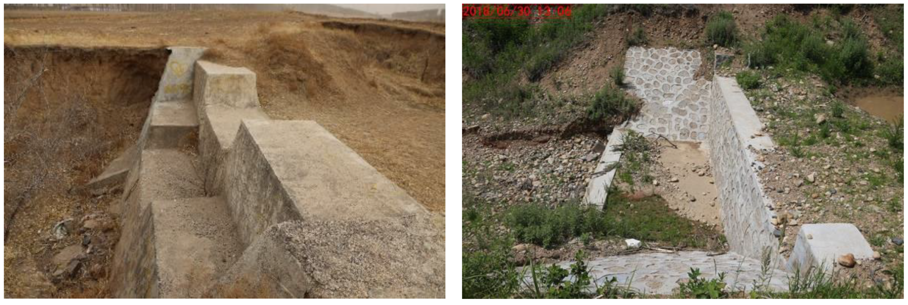
3.1. Arc-Reinforced Concrete and Diversion Masonry Drop Structures

The arc-reinforced concrete drop structure is an arc–chute structure constructed at the gully head with 20 cm thickness and 2 m width having slope steepness less than 45°. After grading, leveling, and compacting the gully, a 20 cm thick sandstone layer is paved, and then concrete is poured on the layer. The edge soil from both sides of the chute should be compacted within the slope of the chute. Bushes are planted for protecting the slope (Figure 4a). This kind of structure is regarded as a first-grade drop structure which is simple and easy to be implemented. Though the structure may experience slight movement with soil freeze/thaw activity, it seldom cracks or exhibits damage. Usually, it is applicable to small gullies (area less than 0.3 ha), ditches along the road, and forest perimeters where the water flow is relatively low in their upper reach.
Arc-concentrated and diversion masonry drop structure is a second-grade drop structure composed of a 2/3 arc–catchment chute, squared but sloped drainage chute and rock riprap (Figure 4b). The 270-degree arc can divert the runoff water from different directions into the guide chute, which stabilizes the gully head through draining the baffled water into the gully bed.
Masonry is used to build the arc–catchment chute, which is approximately 40 cm thick and 1.5 m high. Wall inclination angle is 50–75°, the upper is covered with 2 cm thick cement and parallels the soil surface. The drainage chute is also built by masonry, and its width is equivalent to the bottom of the arc–chute with 20 cm thickness. A 20 cm thick sandstone layer is paved under the structure, and a 30–50 cm high ear wall is built on both sides with slope steepness around 15–30%. The bottom is closely connected with riprap. This practice applies to medium- and small-sized gullies with more runoff from the hillslope.

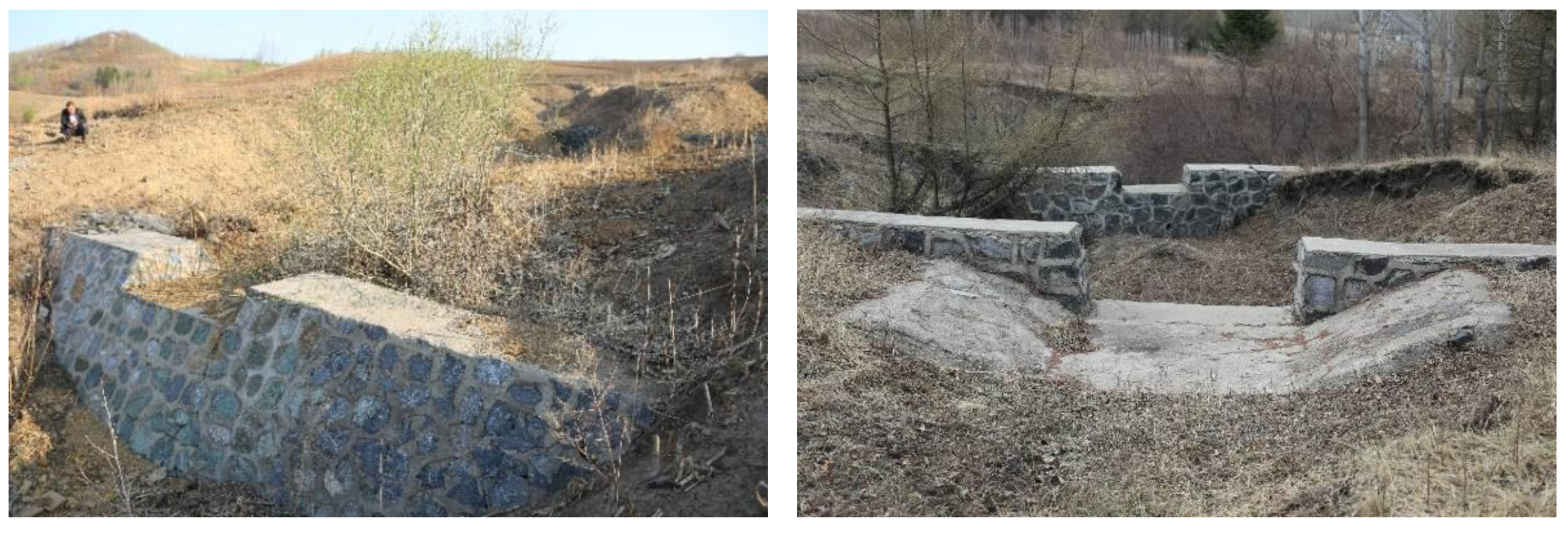
3.2. Masonry Drop Structures for Medium-Sized and Large-Sized Gullies

Masonry drop structure for medium-sized gullies is composed of a catchment chute, retaining wall and stilling basin. The catchment chute is arc-shaped with 20 cm thickness and constructed with small stones and cement. Its width is exactly the same as the headcut width (Figure 5 left). The side walls of the chute are built with masonry, having a 1.5 m high foundation; the exposed height above ground is no more than 3 m, and wall thickness is 0.5 m. The stilling basin is composed of 0.3 m thick masonry protecting walls along the gully bank and square pool at the gully bottom. This structure first collects the flow from the hillslope into the catchment chute and subsequently continues to direct the plunging flow into the stilling basin, and finally into the gully bottom. This is a first-grade drop structure specifically used for headcut control of medium-sized gullies. Prevention of freezing expansion to the foundation is of crucial importance to avoid wall cracking, and thus, the wall base should be built beneath the frost layer.
Masonry drop structure for large-sized gullies is composed of a long aqueduct with low slope gradient, vertical walls, and a stilling basin (Figure 5 right). The building materials are all masonry. The aqueduct is a U-shape chute after the headcut is graded. The chute cross section is designed to meet the maximum 3–6 h rainfall occurring once every 10 years. The chute thickness should be 30–50 cm, while the chute extending to the gully bottom should not exceed 25° slopeness. The aqueduct can be linear or curved. The vertical wall with 1–2 m height is built beneath the aqueduct. The top surface of the wall is at the bottom of the aqueduct, with the same width as that of the aqueduct. The wall thickness is 50 cm. The stilling basin is built adjacent to the vertical wall. This structure is applicable to large-sized gullies with wider headcuts and a slight slope. This structure has higher building costs, though it is more effective in controlling gully erosion than simpler structures. We recommend building a diversion structure and shaping the ground to discharge the flow into one aqueduct. Additionally, for soft or less stable soil areas under the aqueduct, laying and pouring concrete to enhance stability is suggested.

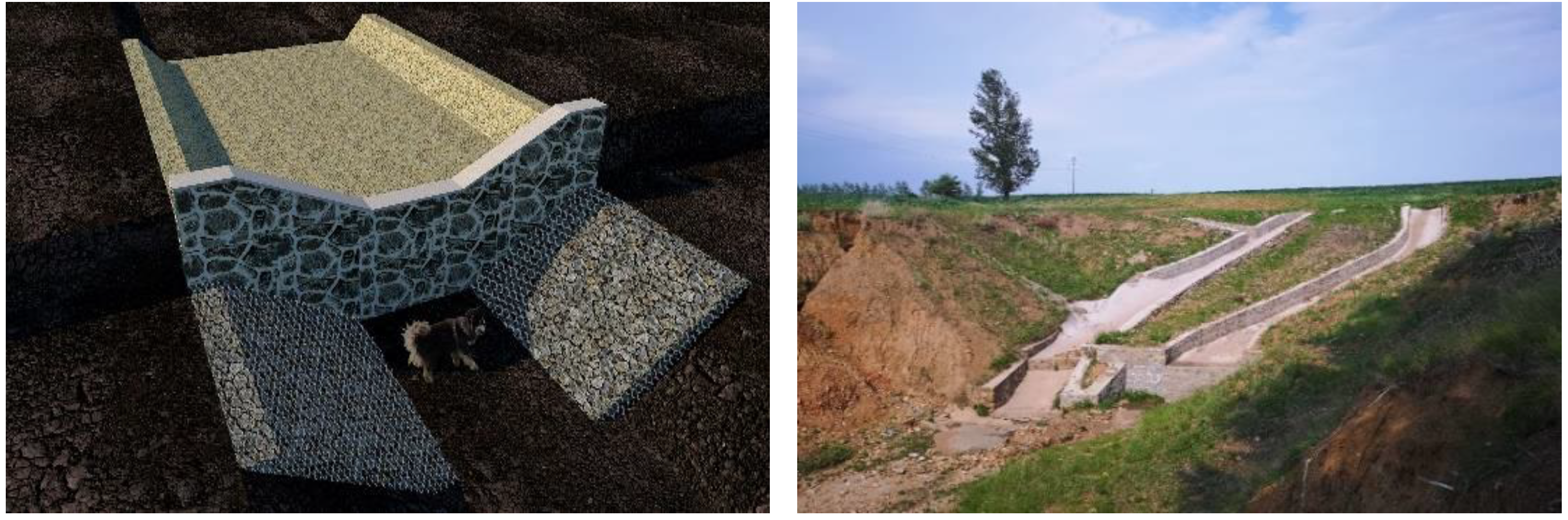
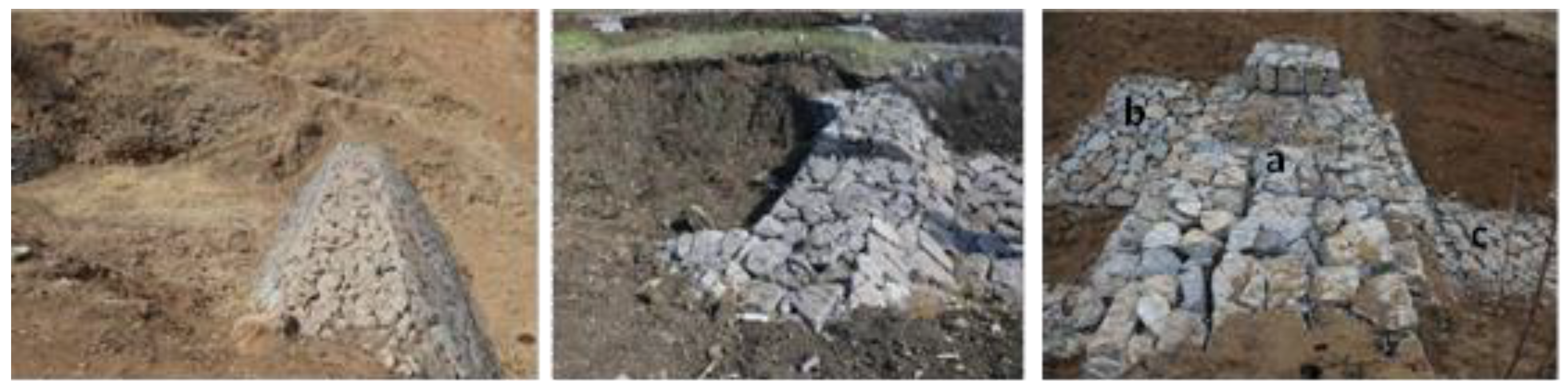
3.3. Drop Structures with Different Sizes of Gabion

There are basically three types of drop structure with gabion. The first is the drop structure with a small-sized gabion. Usually, this drop structure is an “S”-shaped chute, which is constructed from the headcut inlet along the gully with riprap (Figure 6 left). The thickness of the gabion is over 0.3 m with padding layer underneath, while the surface of the padding layer is covered by geotextile filter cloth (a tough nonwoven material). The wire–mesh container is 1 m × 1 m wide, and chute length depends on the actual situation, but the slope should not exceed 45°. It is a simple structure and easy to construct with less material and lower cost than other structures. This structure is applicable to small gullies or semistable gullies with less upstream flow, but not applicable to gullies with more concentrated flow or strong flows at the headcut.
The multilevel terraced drop structure with a medium-sized gabion is composed of terraced gabions, protecting wall and stilling basin (Figure 6, middle). They are all built with 0.6 m high, 0.6 m wide, and 0.80 m long gabions. Though this structure requires relatively more materials, it is durable and relatively easy to construct. This multilevel terraced structure is applicable to medium-sized gullies with more concentrated-flow.
A drop structure with a large-sized gabion is also available. This slope-type ramp with a gentle slope in the upper part is connected to riprap below (Figure 6 right). The gabion is 1 m × 1 m in size and 0.40 m thick. There is a 0.2 m thick padding layer beneath the gabion. The padding layer is first covered by geotextile filter cloth and a plastic net. This structure functions well in transporting flow from multiple directions into the gully bottom and thus is applicable to gullies with a wider headcut. Although more materials are used and more work is required to regrade the headcut, its construction is relatively easier.
Additionally, there are also large arc–concrete drop structures and U-shaped concrete drop structures in the region, but they are not adopted widely.

4. Check Dam Practices of Controlling Gully Bed

A check dam is a common fixed barrier structure constructed with timber, sandbags, gabion, loose rock, masonry or concrete placed across the flow channel [36,37,38,39]. It is designed to intercept runoff, raise the ground water table, and reduce hydrologic connectivity and sediment transport [40,41,42,43,44]. A check dam is composed of the embankment, the spillway, and the outlet in general. Occasionally, some simple check dams are constructed without spillways or outlets [45].
Although check dams had been built in China for centuries, it is only since the founding of the People’s Republic of China that they have been constructed on a large scale, particularly in the Loess Plateau, China [45,46,47]. The construction of check dam systems in gullies was initiated in the early 1980s in Northeast China. Currently, there are mainly four types of check dams in the region.

4.1. Soil Check Dam

Soil from the gully bottom is used to build soil check dam across the gully. The dam is a trapezoidal structure, 1–3 m high and 0.5–1.5 m wide. The upper part is steeper than the lower part. It can consolidate and raise the gully bed and thus stop bottom incision. It can also stabilize the slope and prevent gully expansion and thus reduce sediments (Figure 7).
This practice can be applied in small gullies or medium- and small-sized gullies in semiarid areas for hillslope management. This type of check dam is the simplest and the lowest-cost practice for gully bottom control. However, soil check dams are relatively weak in protecting gully erosion because they mainly intercept runoff and silt and do not transport them. Lady Amherst pheasant (Caragana sinica (Buchoz.) Rehd), sea buckthorn (Hippophae rhamnoides Linn.), and shrub lespedeza (Lespedeza bicolor Turcz.) are usually planted on the dam.

4.2. Masonry Check Dam

In Northeast China, this type of check dam is usually composed of a trapezoidal body, bank protection wall, and stilling pool made from masonry, cobble, cement, and sand. The size of the structure depends on the gully topography. The height is first determined, and then the bottom width, beam ratio, and back slope ratio are designed. The design is clearly specified in GB/T 16453.3. In practice, the height is around 2–5 m.
The shape of the overfall outlet varies as in inverted trapezoid, either rectangle or stepwise. The size of the cross-section should meet the flood peak flow. The top of the bank protection wall should be at least 0.5 m wide. The stilling pool is a square chute constructed with masonry on the gully bed. Representative masonry check dams are shown in Figure 8 and Figure 9.
Sometimes, as required, the masonry check dam can also be used as a supplementary drop structure. This structure is often applied for deep headcut gullies, either small or medium-sized. It is composed of a flow-through opening, retaining wall and check dam (Figure 9 right). The opening is in the shape of an inverted trapezoid constructed with 0.5 m thick masonry, and its surface is covered by cement. The length and width depend on the actual size of the headcut. The retaining wall is constructed across the headcut. Its thickness is 0.5 cm, while its height should be 0.5 cm higher than the headcut line. There is an overfall outlet in the middle of the wall, and the horizontal line of the overfall outlet is 1 m higher than the horizontal line of the retaining wall bottom. A check dam is at the lower end of the retaining wall.
Available stone resources are required for this kind of check dam construction. Experience showed that this kind of check dam is easily damaged by freeze–thaw expansion, and thus, a 1.5 m deep foundation is recommended. Further, cement with high strength grade is preferred. With these requirements, the dam can last at least 20 years in Northeast China.

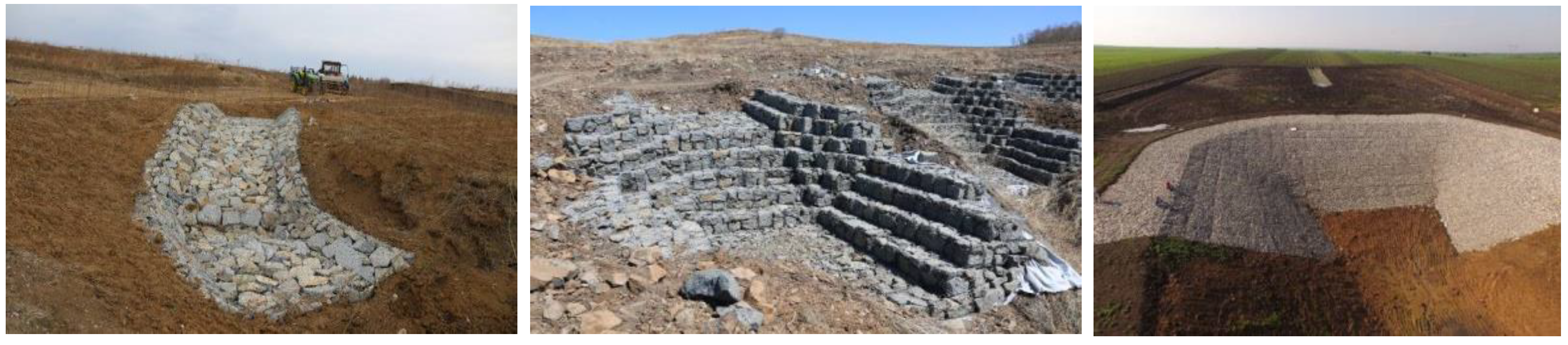
4.3. Gabion Check Dam

The structure is similar to that of a masonry check dam, but with gabions as the building unit. Depending on the actual topographical conditions, a single dam body, step type, one stilling pool or two stilling pools are constructed. In general, the height of the dam body should not exceed 5 m with a width of 1.0–1.5 m on the top. It slopes more steeply towards the surface of the water but more gently against the water. Commonly, the gabion is 0.6 m × 0.6 m × 0.8 m. Larger stones are arranged externally, with small stones refilling the inside. The exposed crevices are controlled at ≤ 2.5 cm, and anticorrosion galvanized wire should be used for the gabion with a specification of 8 cm × 10 cm. A single layer of a guard wall and riprap are paved, respectively. Figure 10 illustrates some representative gabion check dams available in the region.
Gabion check dams hold certain flexibility that can dramatically reduce the damage derived from freeze–thaw expansion to masonry check dams. This practice is easy to construct with fewer materials and a lower cost. However, as it has a certain degree of permeability, the interception of sediment is poorer compared to that of masonry check dams. Further, water channeling sometimes might occur due to water transport through the gully bottom or dam sides, which leads to a damaged dam and less functionality. Thus, a 0.5 m deep foundation is recommended when constructing the dam.
An alternative for controlling the gully bottom erosion is a vegetative check dam, particularly the one we highlight below, i.e., the wicker check dam.

4.4. Wicker Check Dam

As indicated from its name, the core component of the check dam is wicker material. There are two ways to construct the wicker check dam. For a wicker check dam with stones, bunches of multiple wickers, fixed with wooden pins and connected with wire, are laid equidistant from each other. Soils or cobbles fill the spaces between the wicker bunches. For a wicker check dam with soils, 2–3-year-old willows with a 3 cm diameter are inserted into the soil over 0.5 m deep, and above ground 1.0 m high. Then, soils and cobbles are filled among the wickers. Usually, each bundle should have at least 10 wickers and be fixed by wooden stakes every 20 cm. The wicker bundles are laid parallel, crossing the gully with 0.5 m spacing (Figure 11). This is a living check dam with the perfect integration of plant components.

5. Vegetation Rehabilitation for Gully Erosion

Rehabilitating permanent vegetation as quickly as possible is essentially needed to ensure gully erosion control. In Northeast China, the accepted principle of gully management is to prioritize vegetation rehabilitation to enclose the gullies after the establishment of engineering measures, i.e., implementing bioengineering or live stake techniques. The approaches are to use vegetation (locally native, noninvasive species are preferred) to protect channels subjected to high water velocities. In general, there are three commonly used practices.

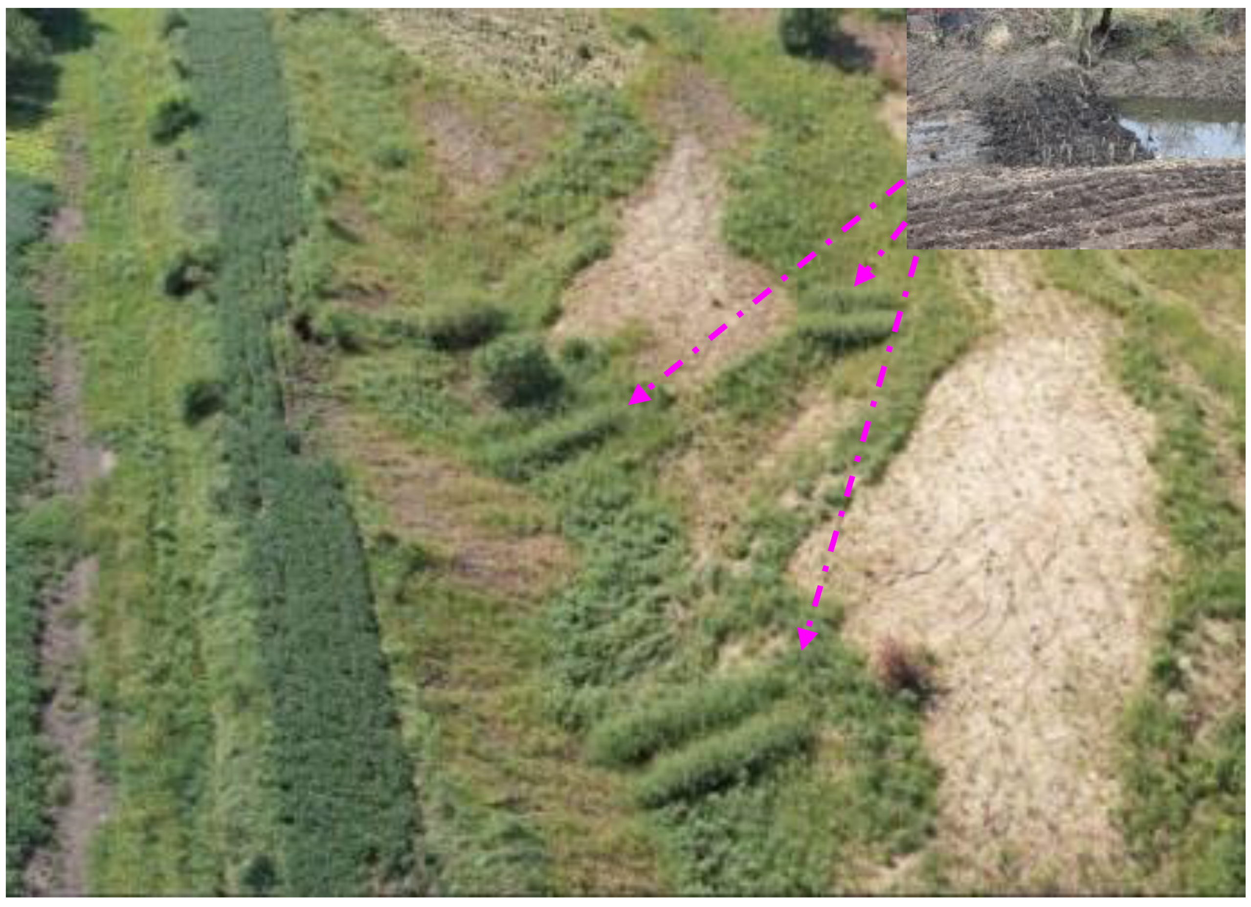
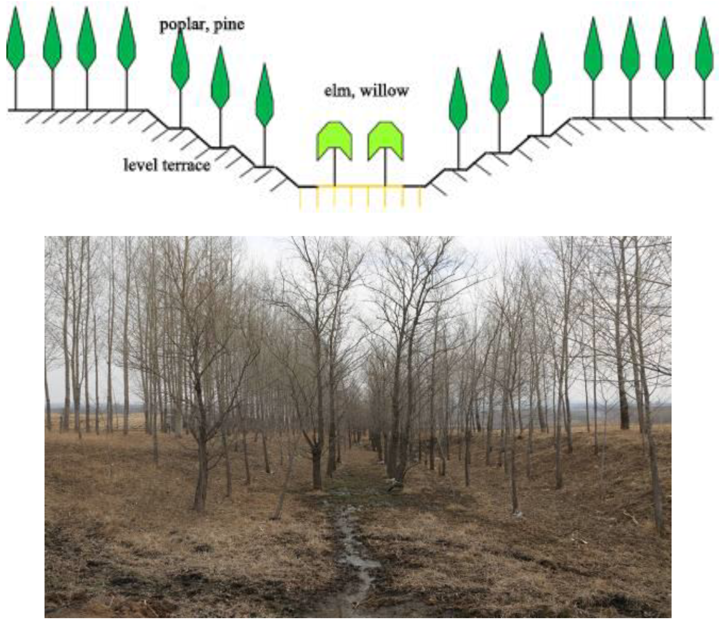
5.1. Continuous Live Wicker

This practice has been used to successfully implement over 1000 gullies in Baiquan County, Heilongjiang Province for the past 4 decades, which has saved at least 50 km2 soil loss area and is being gradually implemented in the northeastern black soil areas. It is either set up from headcut to gully end continuously or arranged in sections according to soil and moisture conditions. The wide-arc-shaped structure ensures that all water flows through the continuous wicker. The wicker must be alive. The slope of the gully bank is regraded below 35°; interval spacing of the live wicker row is 0.5 m (Figure 12). The wicker trunk should be over 2 cm in diameter (5-years old willow) and is inserted 30 cm deep in soil. The above-ground part of the wicker should have at least two buds, and the top surface of the wicker is sealed by paint to reduce transpiration. To implement this practice, it is better to transplant the wicker within 3 days after cutting. If conditions do not allow timely transplanting, bury them in wet soil or soak them in water for short-term preservation. Regrading the slopeness is a must for the successful implementation of this practice. This practice is applicable to gullies inside farmland with better soil fertility and more rainfall, small gullies along roads or branch gullies among medium- and large-sized gullies.

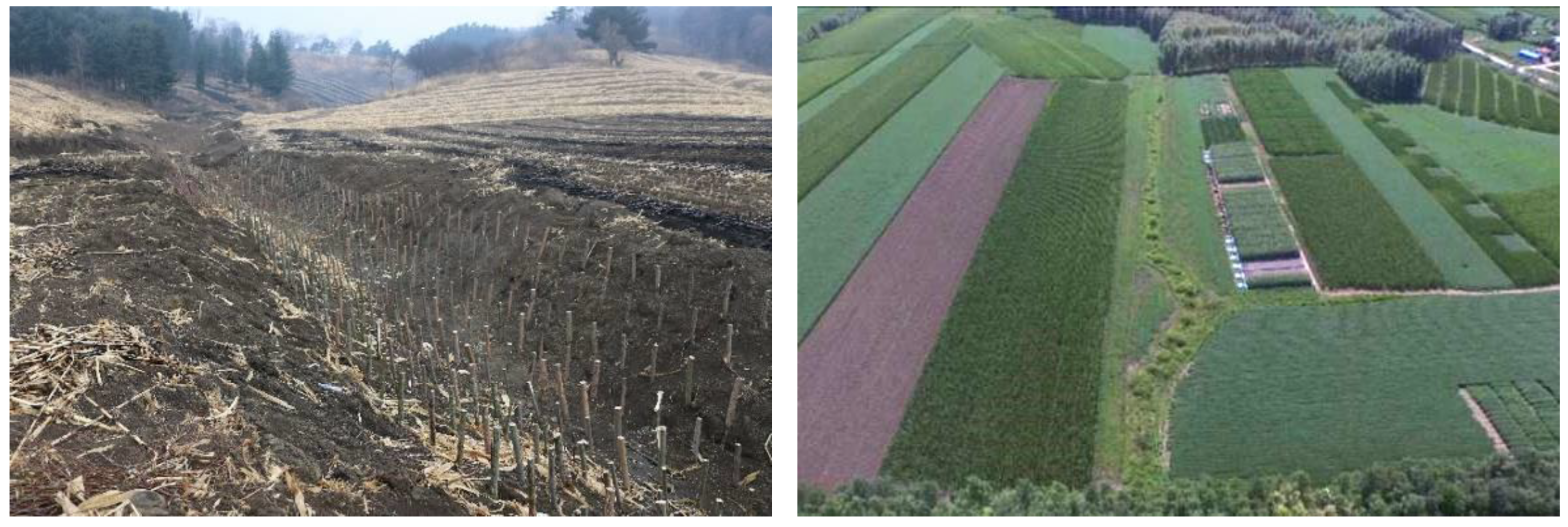
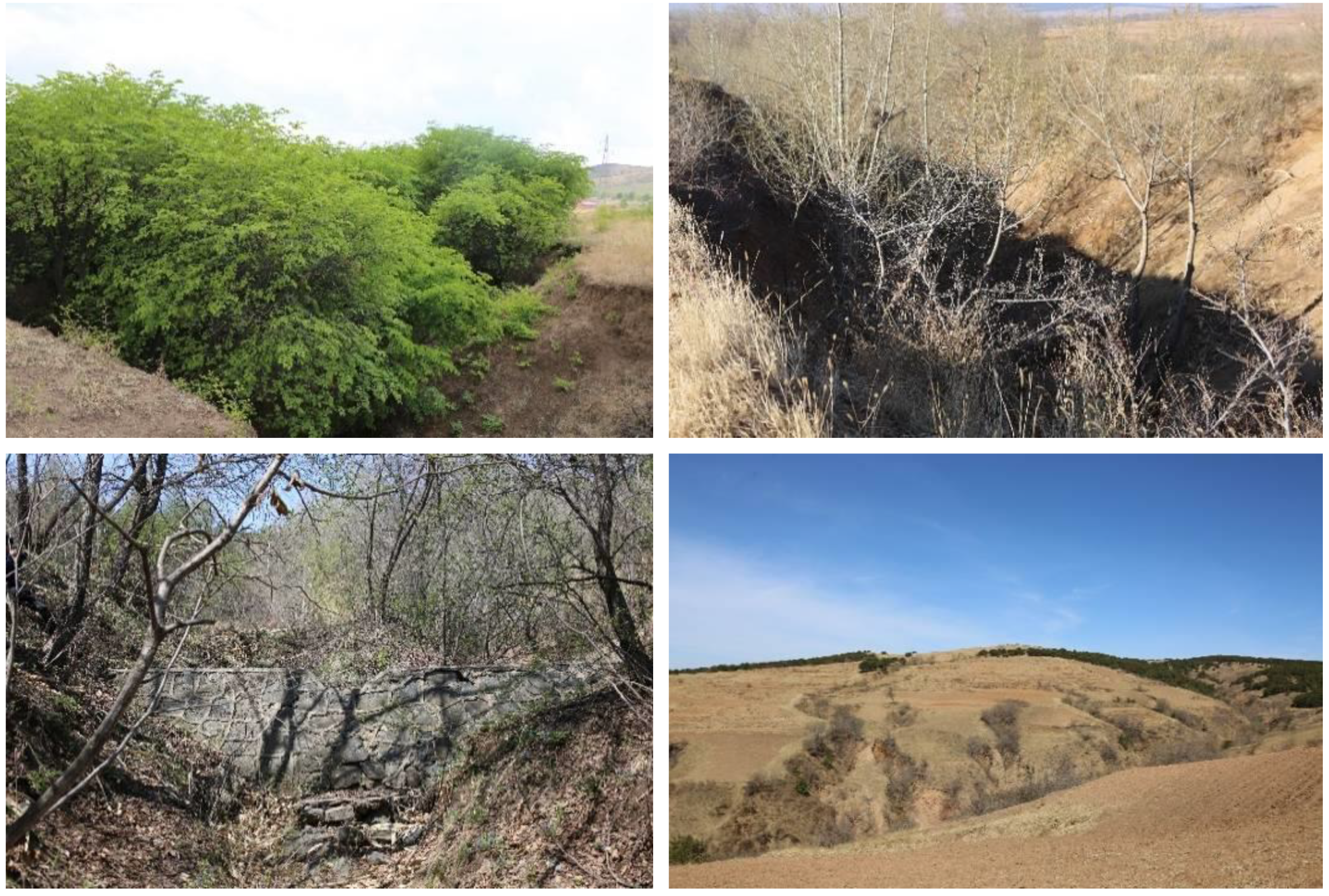
5.2. Shrub Plant Enclosure

Instead of the continuous live wicker, shrub plants are also adopted. To actively developing gullies, shrub drop structures at the headcut with several shrub check dams inside the gully are often established after grading the gullies. The shrub drop structure at the headcut is composed of cross wickers with 20–40 cm spacing downward, and wicker check dams constructed every 5–10 m along the gully bed. Among the dams, live wickers are planted appropriately (Figure 13). For stabilized gullies, simultaneously some shrub plants, such as sea buckthorn (Hippohgae rhamnoides L), caragana-pea tree (Caragana microphylla Lam), hazel (Corylus heterophylla Fisch), shrub lespedeza (Lespedeza bicolor Turcz), false indigo (Amorpha fruticosa L.), and raspberry (Rubus idaeus L.) are planted in the gully bank or down the slope (Figure 13). This practice can develop a system with shrub plants enclosing the whole gully.
Under the current intensive land use scenario in Northeast China, planting shrub plants along the gully bank in the farmland does not affect crop growth and yield, and thus, it is an ecological restoration practice in gully control and is accepted by local farmers.

5.3. Arbor Plant Enclosure

This practice forms a patch of forest. Arbor plants are planted along the gully bank and in the gully bottom. Planting density is denser than a cash forest. If conditions allow, shrubs such as sea buckthorn and shrub lespedeza are interplanted with arbor in a spacing of 1 m. Generally, arbor is planted with 1.5 m × 1.5 m spacings, while shrubs are planted with 0.5 m × 0.5 m spacing. Arbor willow (Salix babylonica L.), and elm (Ulmus pumila L) are planted on the flow path, while poplar (Populus tremula L), pine (Larix gmelinii (Rupr.) Kuzen) and eucalyptus are planted on both sides of the gully wall (Figure 14). Shrubs grow faster and can cover the ground quickly, which is beneficial to the initial management for the gully protection. Thus, it can quickly rehabilitate the vegetation of the gully.
This practice is applicable to medium- and large-sized gullies, particularly gullies along the road and in abandoned land. Depending on the gully site conditions, the artificial forestation by reasonable assembly of arbor trees or mixed with shrub can rehabilitate the ecological environment while managing gully erosion. Although vegetation has an excellent potential to trap sediments, it cannot stop the upslope migration of the gully headcut, but it likely controls gully incision.

6. Discussion

Land must be protected against gully erosion to remain a viable resource indefinitely. Many practices have been developed to mitigate gully erosion in Northeast China. The typical practices constructed at headcuts in a permanent gully are diversion structures and drop structures, which can stabilize the gully head and thus decrease sediment load and concentration [29,48]. At least seven drop structures are available in the region, and their effectiveness is dependent on terrain and gully size. However, the outlets of drop structures for headcut control need to be protected from downstream scour. These problems can gradually be resolved with the improvement of design specification and the layout theory [5], while adoption of reduced tillage and straw mulching could also compliment the effectiveness [49].
There are mainly four types of check dams for controlling gully bed erosion in Northeast China. The immediate application of these dams depends on the topography, gully size, and local economy. Unfortunately, there is a lack of scientific investigations and surveys on the long-term effectiveness of these dams in the region. Further, assessing the changes in the resilience of the available practices to the dynamics of social and natural changes is urgently required.
The larger reduction in gullies with check dams and vegetation can be attributed to the sediments deposited behind the check dams and to the presence of vegetation in the channel that reduces runoff velocity and increases infiltration [38,39]. There are also indications that check dams induce local erosion processes [40,50] and affect the sediment budget at the catchment scale. Do the check dams have the similar consequences in Northeast China? This has to be answered in the future, as no data are available now.
Several researchers indicated that disturbances induced by check dams can be negative when induced erosion is high, or when they create a false stabilization image [38,51]. Nevertheless, the positive effects of subsurface dams on the stability of the check dams can improve the societal perception of the success of gully rehabilitation schemes [35].
In our survey, we also observed the occurrence of collapsed check dams or bypassed check dams in the region, which discouraged the implementations of check dams by local farmers. Therefore, scientific information is required to understand if the detrimental effects of check dams exist in Northeast China.
Bioengineering techniques in Northeast China, such as continuous live wicker, shrub plant enclosures, and arbor plant enclosures, are highly effective in controlling gully erosion. These practices develop a well-planned water management system, which is critical to avoid excessive rill and gully erosion easily occurring on the bare soils and steep slopes. However, only environmentally conscious farmers are willing to support such practices on their fields, because bioengineering techniques are nonprofitable in the short-term. In this regard, future gully erosion management planning should therefore be well designed and developed that could benefit local farmers’ household and income [48].
Practices demonstrated that poor installation defeats the best of practices; thus, technical specifications for gully erosion control practices are required. However, maintenance should not be neglected after the installation of the practices in the region. The local population may abandon conservation practices almost immediately after installation because the local farmers cannot or will not maintain them. Hence, the practices should be inspected periodically and repaired promptly if failure occurs.
Additionally, in accelerating the implementation of gully erosion control practices, policies encouraging individuals and local governments to adopt available practices ought to be established, such as a cost-sharing incentive-based program. Moreover, gully erosion control practices must fit the land, soil characteristics, and socioeconomic conditions where they are applied. The identification of cost-effective gully stabilization practices is still a great challenge in the region.

7. Conclusions

Hillslope erosion and gully erosion are seriously threatening agricultural production and environmental stability in Northeast China. Biological and engineering systems have been developed for controlling gully erosion. The typical practices constructed at headcuts in a permanent gully are diversion structures and drop structures. At least seven drop structures are available in the region, and their effectiveness is dependent on terrain and gully size. There are mainly four types of check dams for controlling gully bed erosion. They are soil check dams, masonry check dams, gabion check dams, and wicker check dams. The application of these dams depends on the topography, gully size, and local economy. Bioengineering techniques in Northeast China, such as continuous live wicker, shrub plant enclosures, and arbor plant enclosures, are highly effective in controlling gully erosion. The critical procedures controlling gully are regrading the gully head and banks, placing riprap on the regraded head and banks, planting various plants (shrub and arbor) on the banks, head or inside gully to enclose relevant area, and thus stabilizing the gully. Sustainable gully erosion management should be based on the participation of local people that recognize and protect traditional land management knowledge. The full understanding of drivers and mechanisms of gully erosion processes will help to achieve sustainable gully management in Northeast China.

Author Contributions

X.L., X.Z.—Concept, discussion and write up; H.L., S.Z.—data collection, analysis, and photo treatments; R.M.C.—Review and write up.

Funding

This research was partially funded by the National Key R&D Program of China [2017YFC0504200] and the National Natural Science Foundation of China [41601289].

Conflicts of Interest

The authors declare no conflict of interest.

References

  1. Valentin, C.; Poesen, J.; Li, Y. Gully erosion: Impacts, factors and control. Catena 2005, 63, 132–153. [Google Scholar] [CrossRef]
  2. Simon, A.; Pollen-Bankhead, N.; Thomas, R.E. Development and application of a deterministic bank stability and toe erosion model for stream restoration. Stream Restor. Dyn. Fluv. Syst. 2011, 453–474. [Google Scholar] [CrossRef]
  3. Ionita, I.; Fullen, M.A.; Zgłobicki, W.; Poesen, J. Gully Erosion as a Natural and Human-Induced Hazard; Springer: Berlin/Heidelberg, Germany, 2015. [Google Scholar]
  4. Shellberg, J.; Spencer, J.; Brooks, A.; Pietsch, T. Degradation of the Mitchell River fluvial megafan by alluvial gully erosion increased by post-European land use change, Queensland, Australia. Geomorphology 2016, 266, 105–120. [Google Scholar] [CrossRef] [Green Version]
  5. Liu, X.; Zhang, X. Gully erosion: Diversity, processes and prospects. Soils Crops 2018, 7, 13. [Google Scholar] [CrossRef]
  6. Chalise, D.; Kumar, L.; Kristiansen, P. Land degradation by soil erosion in Nepal: A review. Soil Syst. 2019, 3, 12. [Google Scholar] [CrossRef]
  7. Takken, I.; Croke, J.; Lane, P. Thresholds for channel initiation at road drain outlets. Catena 2008, 75, 257–267. [Google Scholar] [CrossRef]
  8. Ma, H.; Zhao, H. United Nations: Convention to combat desertification in those countries experiencing serious drought and/or desertification, particularly in Africa. Int. Leg. Mater. 1994, 33, 1328–1382. [Google Scholar] [CrossRef]
  9. Lal, R. Soil degradation by erosion. Land Degrad. Dev. 2001, 12, 519–539. [Google Scholar] [CrossRef]
  10. Yitbarek, T.; Belliethathan, S.; Stringer, L. The onsite cost of gully erosion and cost-benefit of gully rehabilitation: A case study in Ethiopia. Land Degrad. Dev. 2012, 23, 157–166. [Google Scholar] [CrossRef]
  11. Kidane, D.; Alemu, B. The effect of upstream land use practices on soil erosion and sedimentation in the Upper Blue Nile Basin, Ethiopia. Res. J. Agric. Environ. Manag. 2015, 4, 55–68. [Google Scholar]
  12. Ayele, G.K.; Gessess, A.A.; Addisie, M.B.; Tilshun, S.A.; Tenessa, D.B.; Langendoen, E.J.; Steenhuis, T.S.; Nicholson, C.F. The economic cost of upland and gully erosion on subsistence agriculture for a watershed in the Ethiopian highlands. Afr. J. Agric. Resour. Econ. 2015, 10, 265. [Google Scholar]
  13. Mararakanye, N.; Sumner, P.D. Gully erosion: A comparison of contributing factors in two catchments in South Africa. Geomorphology 2017, 288, 99–110. [Google Scholar] [CrossRef] [Green Version]
  14. Zegeye, A.D.; Langendoen, E.J.; Guzman, C.D.; Dagnew, D.C.; Amare, S.D.; Tilahun, S.A.; Steenhuis, T.S. Gullies, a critical link in landscape soil loss: A case study in the subhumid highlands of Ethiopia. Land Degrad. Dev. 2018, 29, 1222–1232. [Google Scholar] [CrossRef]
  15. Chalise, D.; Kumar, L.; Shriwastav, C.P.; Lamichhane, S. Spatial assessment of soil erosion in a hilly watershed of Western Nepal. Environ. Earth Sci. 2018, 77, 685. [Google Scholar] [CrossRef]
  16. Liu, X.; Zhang, X.; Wang, Y.; Sui, Y.; Zhang, S.; Herbert, S.; Ding, G. Soil degradation: A problem threatening the sustainable development of agriculture in Northeast China. Plant Soil Environ. 2010, 56, 87–97. [Google Scholar] [CrossRef]
  17. Liu, X.; Lee Burras, C.; Kravchenko, Y.S.; Duran, A.; Huffman, T.; Morras, H.; Studdert, G.; Zhang, X.; Cruse, R.M.; Yuan, X. Overview of Mollisols in the world: Distribution, land use and management. Can. J. Soil Sci. 2012, 92, 383–402. [Google Scholar] [CrossRef]
  18. Li, W.; Zhang, P.; Song, Y. Analysis on Land Development and Causes in Northeast China during Qing Dynasty. Sci. Geogr. Sin. 2005, 25, 7–16. [Google Scholar] [CrossRef]
  19. Zhang, X.; Liang, A.; Shen, Y. Erosion characteristics of black soils in Northeast China. Sci. Geogr. Sin. 2006, 26, 692. [Google Scholar]
  20. Song, Y. Eco-environment protection and construction of green community in northeast China. Sci. Geogr. Sin./Dili Kexue 2002, 22, 659–668. [Google Scholar] [CrossRef]
  21. Liu, B.; Yan, B.; Shen, B.; Wang, Z.; Wei, X. Current status and comprehensive control strategies of soil erosion for cultivated land in the Northeastern black soil area of China. Sci. Soil Water Conserv. 2008, 6, 8. [Google Scholar] [CrossRef]
  22. Fan, H.; Gu, G.; Wang, Y. Characteristics of eroded gully development and environment of black soil region in Northeast China. Soil Water Conserv. China 2013, 10, 75–79. [Google Scholar] [CrossRef]
  23. Li, Z.; Wang, Y.; Liu, X.; Liu, J. Survey methods and results of erosion gullies in black soil areas of northeastern China. Sci. Soil Water Conserv. 2013, 11, 5. [Google Scholar] [CrossRef]
  24. Bai, J.; Hui, L. Preliminary investigation on gully development and harm in Black Soil Region of Northeast China. Soil Water Conserv. China 2015, 8, 3. [Google Scholar] [CrossRef]
  25. Wang, Y.; Xie, Y.; Wang, P. Analysis on the causes of soil erosion in black soil region of Northeast China. Sci. Tech. Inf. Soil Water Conserv. 2002, 3, 27–29. [Google Scholar] [CrossRef]
  26. Wang, W.; Zhang, S.; Deng, R. Gully status and relationship with landscape pattern in black soil area of Northeast China. Trans. Chin. Soc. Agric. Eng. 2011, 27, 192–198. [Google Scholar] [CrossRef]
  27. Liu, X.; Yan, B. Soil erosion and food security in Northeast China. Chin. J. Soil Water Conserv. 2009, 1, 17–19. [Google Scholar] [CrossRef]
  28. Yang, J.; Zhang, S.; Chang, L.; Li, F.; Li, T.; Gao, Y. Gully erosion regionalization of black soil area in northeastern China. Chin. Geogr. Sci. 2017, 27, 78–87. [Google Scholar] [CrossRef] [Green Version]
  29. Zhang, X.; Hui, L. The Achievement of Comprehensive Soil Erosion Control in Northeast China; China Water Power Press: Beijing, China, 2015. [Google Scholar]
  30. Ceballos, A.; Cerda, A.; Schnabel, S. Runoff production and erosion processes on a dehesa in western Spain. Geogr. Rev. 2002, 92, 333–353. [Google Scholar] [CrossRef]
  31. Poesen Vandekerckhove, L.; Nachtergaele, J.; Oostwoud Wijdenes, D.; Verstraeten, G.; Van Wesmael, B. Gully Erosion in Dryland Environments. Dryland Rivers: Hydrology and Geomorphology of Semi-Arid; John Wiley Sons Ltd.: Chichester, UK, 2002. [Google Scholar]
  32. Toy, T.J.; Foster, G.R.; Renard, K.G. Soil Erosion: Processes, Prediction, Measurement, and Control; John Wiley Sons: Hoboken, NJ, USA, 2002. [Google Scholar]
  33. Ziadat, F.M.; Taimeh, A. Effect of rainfall intensity, slope, land use and antecedent soil moisture on soil erosion in an arid environment. Land Degrad. Dev. 2013, 24, 582–590. [Google Scholar] [CrossRef]
  34. SSAJ. Glossary of Soil Science Terms 2008; The American Society of Agronomy-Crop Science Society of America-Soil Science Society of America: Madison, WI, USA, 2008. [Google Scholar]
  35. Frankl, A.; Poesen, J.; Haile, M.; Deckers, J.; Nyssen, J. Quantifying long-term changes in gully networks and volumes in dryland environments: The case of Northern Ethiopia. Geomorphology 2013, 201, 254–263. [Google Scholar] [CrossRef] [Green Version]
  36. Huang, J.; Hinokidani, O.; Yasuda, H.; Ojha, C.S.; Kajikawa, Y.; Li, S. Effects of the check dam system on water redistribution in the Chinese Loess Plateau. J. Hydrol. Eng. 2012, 18, 929–940. [Google Scholar] [CrossRef]
  37. Nyssen, J.; Veyret-Picot, M.; Poesen, J.; Moeyersons, J.; Haile, M.; Deckers, J.; Govers, G. The effectiveness of loose rock check dams for gully control in Tigray, northern Ethiopia. Soil Use Manag. 2004, 20, 55–64. [Google Scholar] [CrossRef]
  38. Borja, P.; Molina, A.; Govers, G.; Vanacker, V. Check dams and afforestation reducing sediment mobilization in active gully systems in the Andean mountains. Catena 2018, 165, 42–53. [Google Scholar] [CrossRef]
  39. Castillo, V.; Mosch, W.; García, C.C.; Barberá, G.; Cano, J.N.; López-Bermúdez, F. Effectiveness and geomorphological impacts of check dams for soil erosion control in a semiarid Mediterranean catchment: El Cárcavo (Murcia, Spain). Catena 2007, 70, 416–427. [Google Scholar] [CrossRef]
  40. Hassanli, A.M.; Nameghi, A.E.; Beecham, S. Evaluation of the effect of porous check dam location on fine sediment retention (a case study). Environ. Monit. Assess. 2009, 152, 319–326. [Google Scholar] [CrossRef] [PubMed]
  41. Nyssen, J.; Clymans, W.; Descheemaeker, K.; Poesen, J.; Vandecasteele, I.; Vanmaercke, M.; Zenebe, A.; Van Camp, M.; Haile, M.; Haregeweyn, N. Impact of soil and water conservation measures on catchment hydrological response—A case in north Ethiopia. Hydrol. Process. 2010, 24, 1880–1895. [Google Scholar] [CrossRef]
  42. Polyakov, V.; Nichols, M.; McClaran, M.; Nearing, M. Effect of check dams on runoff, sediment yield, and retention on small semiarid watersheds. J. Soil Water Conserv. 2014, 69, 414–421. [Google Scholar] [CrossRef] [Green Version]
  43. Remaître, A.; Van Asch, T.W.; Malet, J.-P.; Maquaire, O. Influence of check dams on debris-flow run-out intensity. Nat. Hazards Earth Syst. Sci. 2008, 8, 1403–1416. [Google Scholar] [CrossRef]
  44. Xu, X.; Zhang, H.; Zhang, O. Development of check-dam systems in gullies on the Loess Plateau, China. Environ. Sci. Policy 2004, 7, 79–86. [Google Scholar] [CrossRef]
  45. Feng, G. The key to bring the Yellow River under control is to speed up construction of check-dams in the Sandy and Grit Areas. Sci. Technol. Rev. 2000, 145, 53–57. [Google Scholar] [CrossRef]
  46. Ran, D.; Luo, Q.; Zhou, Z.; Wang, G.; Zhang, X. Sediment retention by check dams in the Hekouzhen-Longmen Section of the Yellow River. Int. J. Sediment Res. 2008, 23, 159–166. [Google Scholar] [CrossRef]
  47. Atreya, K.; Sharma, S.; Bajracharya, R.M.; Rajbhandari, N.P. Developing a sustainable agro-system for central Nepal using reduced tillage and straw mulching. J. Environ. Manag. 2008, 88, 547–555. [Google Scholar] [CrossRef]
  48. Assefa, E.; Hans-Rudolf, B. Farmers’ perception of land degradation and traditional knowledge in Southern Ethiopia—resilience and stability. Land Degrad. Dev. 2016, 27, 1552–1561. [Google Scholar]
  49. Porto, P.; Gessler, J. Ultimate bed slope in Calabrian streams upstream of check dams: Field study. J. Hydraul. Eng. 1999, 125, 1231–1242. [Google Scholar] [CrossRef]
  50. Boix-Fayos, C.; de Vente, J.; Martínez-Mena, M.; Barberá, G.G.; Castillo, V. The impact of land use change and check-dams on catchment sediment yield. Hydrol. Process. Int. J. 2008, 22, 4922–4935. [Google Scholar] [CrossRef]
  51. Bewket, W. Soil and water conservation intervention with conventional technologies in northwestern highlands of Ethiopia: Acceptance and adoption by farmers. Land Use Policy 2007, 24, 404–416. [Google Scholar] [CrossRef]
Figure 1. Gully erosion regionalization map of black soil area in Northeastern China (Yang et al., 2017).
Sustainability 11 05065 g001
Figure 2. Biological system for gully control (photo taken by Dr. H. Li in May 2016, Bawuwu State farm, Heilongjiang Province).
Sustainability 11 05065 g002
Figure 3. Engineering system for gully control (photo taken by Dr. X.Y. Zhang in July 2018, Arongqi County, Inner Mongolia Autonomous Region).
Sustainability 11 05065 g003
Figure 4. Arc-reinforced concrete and arc-concentrated and diversion masonry drop structure (photo taken by Dr. X.Y. Zhang in July 2018, Wulanhaote City, Inner Mongolia Autonomous Region).
Sustainability 11 05065 g004
Figure 5. Masonry drop structure for medium-sized (left) and large-sized gullies (right) (photos taken by Dr. X.Y. Zhang in June 2018, Hailin County, Heilongjiang Province).
Sustainability 11 05065 g005
Figure 6. Drop structures with small-sized gabion (left), medium-sized gabion (middle), and large-sized gabion (right) (left and middle photos taken by Dr. X.Y. Zhang in April 2018, Dunhua City, Jilin Province; right photo taken by Dr. H. Li in June 2016, Hailun City, Heilongjiang Province).
Sustainability 11 05065 g006
Figure 7. Typical soil check dams (photos taken by Dr. X.Y. Zhang in May 2018, Zhangwu County, Liaoning Province).
Sustainability 11 05065 g007
Figure 8. Step (left) and inverted trapezoid (right) type masonry check dam with cement surface (photos taken by Dr. X.Y. Zhang in May 2018, Zhangwu County, Liaoning Province and in August 2018, Hailin City, Hielongjiang Province).
Sustainability 11 05065 g008
Figure 9. Rectangle type masonry check dam with cement surface (left) and masonry check dam supplement drop structure (right) (photos taken by Dr. X.Y. Zhang in April 2018, Liuhe County and Dongliao County, Jilin Province).
Sustainability 11 05065 g009
Figure 10. Gabion check dam with step body without an overfall outlet (left), double overfall outlets and riprap (middle), and footpath with a cement cover (right) (a, spillway; b, revetment; c, apron extension) (left, middle, and right photos taken by Dr. X.Y. Zhang in June 2018, Fuxin City; in July 2018, Kaiyuan City; and in April 2018, Fushun County, Liaoning Province).
Sustainability 11 05065 g010
Figure 11. Typical wicker check dams (upper right corner, check dam establishment) (photo taken by Dr. X.Y. Zhang in July 2018, Kaiyuan City, Liaoning Province).
Sustainability 11 05065 g011
Figure 12. Shrub plant enclosure part view (left) and overall view (right) (left photo taken by Dr. XY Zhang in April 2017, Kaiyuan County, Liaoning Province; right photo taken by Dr. H. Li in May 2016, Hailun County, Heilongjiang Province).
Sustainability 11 05065 g012
Figure 13. Shrub plants enclosing the gullies (upper left, sea buckthorn; upper right, hazel; lower left, false indigo; lower right, caragana-pea tree) (photos taken by Dr. X.Y. Zhang in April 2018, Tonghua City, Dunhua County, Liuhe County, Jilin Province and Fuxin City, Liaoning Province).
Sustainability 11 05065 g013
Figure 14. Arbor plant enclosure (upper, diagram; lower, 10 years after arbor enclosure) (photo taken by Dr. X.Y. Zhang in April 2015, Hailun County, Heilongjiang Province).
Sustainability 11 05065 g014

