Article

Hydrological Condition Constrains Vegetation Dynamics for Wintering Waterfowl in China’s East Dongting Lake Wetland

1
State Cultivation Base of Eco-agriculture for Southwest Mountainous Land, Southwest University, Chongqing 400715, China
2
Chongqing Engineering Research Center for Remote Sensing Big Data Application, School of Geographical Sciences, Southwest University, Chongqing 400715, China
3
Poyang Lake Wetland and Watershed Research (Jiangxi Normal University), Ministry of Education, Nanchang 330022, China
*
Authors to whom correspondence should be addressed.
Sustainability 2019, 11(18), 4936; https://doi.org/10.3390/su11184936
Submission received: 7 August 2019 / Revised: 28 August 2019 / Accepted: 6 September 2019 / Published: 10 September 2019
(This article belongs to the Section Sustainable Agriculture)

Abstract

:
As an internationally important wintering region for waterfowls on the East Asian–Australasian Flyway, the national reserve of China’s East Dongting Lake wetland is abundant in animal and plant resources during winter. The hydrological regimes, as well as vegetation dynamics, in the wetland have experienced substantial changes due to global climate change and anthropogenic disturbances, such as the construction of hydroelectric dams. However, few studies have investigated how the wetland vegetation has changed over time, particularly during the wintering season, and how this has directly affected habitat suitability for migratory waterfowl. Thus, it is necessary to monitor the spatio-temporal dynamics of vegetation in the protected wetland and explore the potential factors that alter it. In this study, the data set of time-series Moderate Resolution Imaging Spectroradiometer (MODIS) normalized difference vegetation index (NDVI) from 2000 to 2018 was used to analyze the seasonal dynamics and interannual trends of vegetation over the wintering period from October to January. The results showed that the average NDVI exhibited an overall increasing trend, with the trend rising slowly in recent years. The largest monthly mean NDVI generally occurred in November, which is pertinent to the quantity of wintering waterfowl in the East Dongting Lake wetland. Meanwhile, the mean NDVI in the wintering season is significantly correlated to temperature and water area, with apparent lagging effects. Long-term stability analysis presented a gradually decreasing pattern from the central body of water to the surrounding area. All analyses will help the government to make appropriate management strategies to protect the habitat of wintering waterfowl in the wetland.

1. Introduction

Wetland is recognized as one of the most important ecosystems on earth and is generally distributed in the transitional zone between land and water, which has irreplaceable ecological value for protecting species and maintaining biodiversity [1]. Wetlands are dynamic and diverse in not only spatial patterns but also in hydrological conditions and vegetation communities [2]. Understanding the interrelations between vegetation distribution and hydrologic regimes can assist in their effective management. As a key component of wetland ecosystems, vegetation plays a vital role in environmental functions [3,4]. In particular, diverse plant communities can provide good breeding, habitat, wintering, and foraging sites for waterfowls [5,6]. Therefore, an in-depth study upon the underlying mechanism of vegetation dynamics is helpful for understanding the necessary processes to ensure the stability of wetland ecosystems and protecting the habitat of wintering waterfowl.
Traditional vegetation survey methods generally require intensive field work, and are laborious, time consuming, and inaccessible. Cumulatively, such issues can lead to them only being used to assess relatively small areas [7]. Alternatively, satellite remote sensing offers an economical and effective approach to monitor the dynamics of wetland vegetation at multiple spatial and temporal scales [8]. In addition, the associated data can be easily integrated into a geographic information system (GIS) for spatial analysis [9]. The vegetation index is considered as a relatively mature remote sensing estimation method with simple calculation and high accuracy [10], which has been applied in many researches. As a typical vegetation index, the normalized difference vegetation index (NDVI) is not only an important parameter reflecting vegetation growth status and coverage but also can represent the food abundance for wintering waterfowl [11,12]. Hence, the application of remote sensing technology to monitor wetland vegetation plays an important role in biodiversity protection, habitat assessment, and wetland resource management for overwintering waterfowl.
The East Dongting Lake wetland is one of the most important wintering regions in the Yangtze River floodplain for hundreds of thousands of migratory waterfowl traversing the East Asian–Australasian Flyway [13]. Waterfowls are good indicators of environmental changes and natural resources of great ecological value [14], whose abundance is positively related with the availability of wetland habitats [15,16], such as food resources [17,18], habitat size and structure [19], water level fluctuations [20], human disturbance [21], competitors [22], and so on. Among these factors, water regimes and food availability are considered to be the most important factors that influence the distribution and abundance of individual species of waterfowl [23,24]. Affected by global climate change and annual monsoonal flooding followed by water level recession in Yangtze River Floodplain [25,26], East Dongting Lake forms a unique landscape feature, which is open water in summer and a wetland landform in winter. The specific hydrological cycle and climatic factor create extensive, ephemeral, and highly productive wetlands [27]. However, with the operation of the Three Gorges Dam (TGD) and climatic changes over the past few decades, the hydrological regime of East Dongting Lake has endured obvious changes [28,29,30,31]. These have, in turn, severely impacted ecosystem services of the wetland [32,33,34,35]. Under the dual effects of changes in the natural environment and human activities [36], the vegetation characteristics and the carrying capacity of migratory birds of the East Dongting Lake wetland are inevitably altered. Hence, in recent years, it has become a central issue in ecology to study the effects of the hydrological regime and climatic change on the important East Dongting Lake wetland [37].
Changes in the wetland vegetation are of great significance to ensure the biodiversity and the restoration of wintering waterfowl habitats, as well as the rational management of wetland resources. Previous studies have explored the environmental factors that affect waterfowl habitats as a whole, including the effect of vegetation on an annual time scale [38]. However, in-depth analysis of vegetation dynamics, as well as the driving forces and the related analysis of wintering waterfowl from the perspective of the wintering season remain scarce. This is regrettable because the wintering season is a critical period for waterfowl, which influences the water conditions, and thereby the spring departure time and subsequent reproductive success [39]. To address this gap in the existent knowledge, the remote sensing and GIS techniques were integrated to address the seasonal and interannual dynamics of spatial vegetation in the East Dongting Lake wetland during the wintering season of waterfowl, from 2000 to 2018, and the interactions between climate change, hydrological conditions, and vegetation dynamics were explored. The results provide insights into the strategies of wetland management and the conservation of waterfowl habitats in the middle Yangtze River floodplains.

2. Materials and Methods
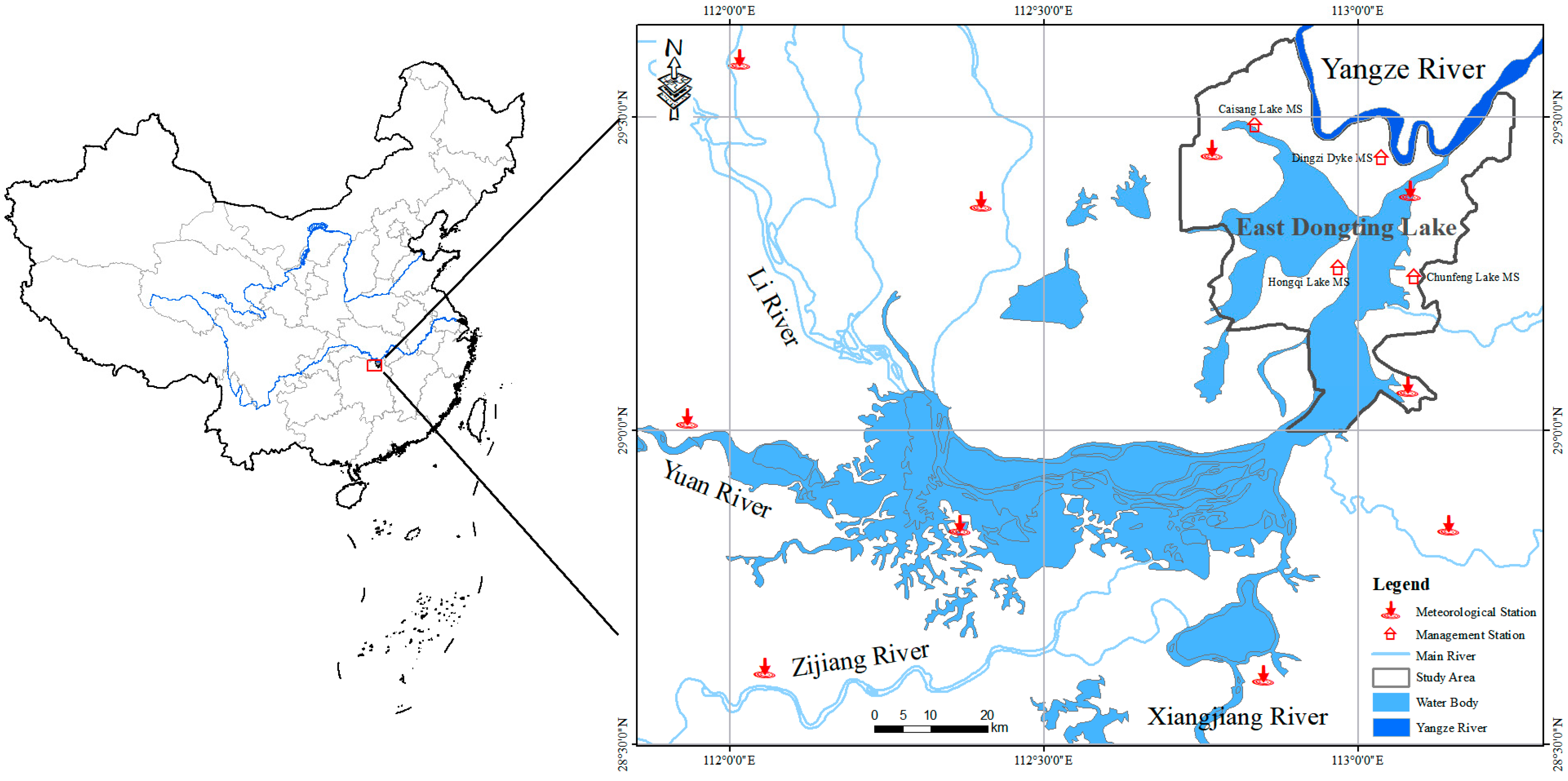
2.1. Study Area

This study was conducted at the East Dongting Lake National Nature Reserve (Figure 1), which lies on the southern bank of the middle Yangtze River, China [40]. The region possesses a subtropical monsoon climate. The annual mean temperature ranges from 16.4 to 17.0 °C, and annual precipitations range from 1200 to 1330 mm. The wetland is about 1900 km2, and includes freshwater lakes, marshes, and seasonally submerged moss meadows. As a seasonally inundated water body, the water level fluctuates seasonally and annually, thereby creating and maintaining a dynamic landscape of marshlands in winter and flood plains in summer [41,42]. There are abundant vegetation resources, with more than 1000 species.
In addition, as the major part of the Dongting Lake, the East Dongting Lake is influenced by the periodic fluctuation of water levels of the Yangtze River, the Xiangjiang River, the Zi River, the Yuan River, and the Li River systems. The landforms of the East Dongting Lake vary greatly throughout one year, with the wet season from May to June, the retreating season from October to December, and the dry season from January to March in the following year. The maximum water level drop in one year can reach 17 m. Especially when the water level reduces in winter, large areas of resultant recessional mudflats and sedge meadow provide critical habitat and food resources for herbivorous Anatidae species [43,44], with the largest population among the waterfowls. The East Dongting Lake wetland has become an important wintering habitat for migratory birds. It has recorded 14 orders, 50 families, and 335 species of birds over the last few decades. Every year, about 30% of waterfowls reach the East Dongting Lake wetland in October and then spread to surrounding areas; about 60% come to the East Donting Lake to roost in November. Nearly 10% of the total waterfowls gather in this winter habitat before migrating.

2.2. Satellite Data

NDVI is one of the most widely used parameters for vegetation remote sensing, and is also an important indicator of vegetation growth status. Its formula is:
NDVI = N I R R N I R + R ,
where NIR and R represent the reflectance in MODIS near infrared (841–876 nm) and red (620–670 nm) bands, respectively. The remote sensing data in this study are from the MODIS-Terra MOD13Q1 product provided by the United States Geological Survey. We used the 16-day MODIS NDVI and MODIS NIR composites with a 250-m spatial resolution in a sinusoidal projection due to their capacity to detect time-series vegetation dynamics and water areas. The product is generated using a maximum value compositing method (MVC) in order to limit residual cloud and atmospheric effects. We finally obtained 432 MOD13Q1 images for the period from October 2000 to January 2018 (inclusive), for MODIS tiles h27v05, h27v06, and h28v06. As MOD13Q1 belongs to the MODIS level 3 data product, the data is calibrated and distortion-corrected. Therefore, in this study, the MODIS Re -Projection Tools (MRT) software was used to perform splicing, format, and projection conversion. Thereafter, the area of the East Dongting Lake Nature Reserve was used for mask cutting to obtain the study area.
Finally, the MVC method was used to synthesize the monthly data in order to obtain the best state of the wetland vegetation on a monthly time scale. The NDVI value of each wintering season was calculated from the average value of the four months during October, November, December, and January.

2.3. Meteorological Data

Climate factors are considered to be the important environmental factors that affect vegetation dynamics [45]. The temperature and precipitation data were derived from the National Meteorological Information Center, which undergoes strict quality control, extreme value tests, and time consistency tests. We obtained data from a total of 10 meteorological stations in and around the study area from October 2000 to January 2018. The long-term temperature and precipitation data were used to analyze its impact on vegetation changes. The daily temperature and cumulative precipitation were respectively averaged and accumulated on different time scales (monthly and seasonal). Then, the spatial analysis tool of ArcGIS was used to carry out spatial interpolation processing on these meteorological data using the inverse distance weighted interpolation method, with a spatial resolution of 250 m, so that the final interpolation results matched the MOD13Q1 data.

2.4. Liner Trend Analysis

In order to study the spatial trends of the vegetation dynamics in the East Dongting Lake wetland during a series of wintering seasons, the linear trend analysis method was used to simulate the changes of the NDVI value for each pixel. The variation degree in NDVI is expressed by the slope of the linear regression equation, with one variable obtained by the least square method:
slope = n × i = 1 n i × N D V I i i = 1 n i × i = 1 n N D V I i n × i = 1 n i 2 ( i = 1 n i ) 2 ,
where n is the number of wintering seasons, NDVIi is the NDVI value of the i-th wintering season; if the slope > 0, it indicates that the NDVI value has an increasing trend during n years; otherwise, if the slope < 0, it exhibits a decreasing trend. The trends of interannual NDVI were subjected to a significance test, with significantly decreased (θ < 0, p ≤ 0.01), slightly decreased (θ < 0, 0.01 < p ≤ 0.05), basically unchanged (θ < 0 or θ > 0, p > 0.05), slightly increased (θ > 0, 0.01 < p ≤ 0.05), and significantly increased (θ > 0, p ≤ 0.01) [46]. This enabled the vegetation trend map of the East Dongting Lake wetland during the wintering season from 2000 to 2018 to be constructed, as well as the area statistics.

2.5. Stability Analysis

To analyze the spatial fluctuations of long-term vegetation NDVI, the variation coefficients of seasonal and monthly mean NDVI in the East Dongting Lake wetland during wintering seasons were calculated on the pixel scale to evaluate the stability:
C v = δ / x ¯ ,
where Cv is the variation coefficient, δ is the standard deviation, x ¯ is the average value, and Cv represents the dispersion of the data distribution. It follows that the smaller the value of Cv indicates that the data distribution is relatively compact, the data is steady on the time series scale, and the vegetation community state is stable. In contrast, it reflects poor stability. In this study, the stability was divided into six grades, with C1 (0 ≤ Cv < 0.05), C2 (0.05 ≤ Cv < 0.10), C3 (0.10 ≤ Cv < 0.15), C4 (0.15 ≤ Cv < 0.20), C5 (0.20 ≤Cv < 0.25), and C6 (0.25 ≤Cv < 0.30) [47].

3. Results

3.1. Temporal Analysis of Vegetation Variation

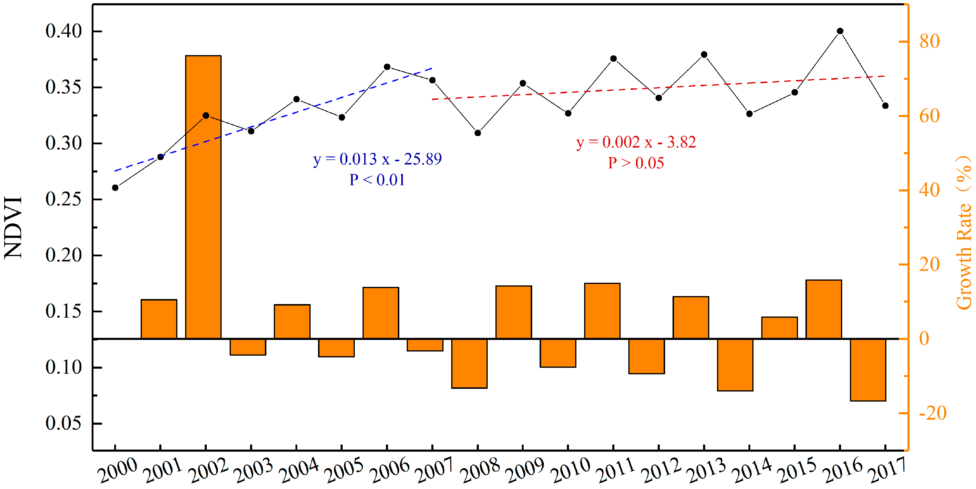
3.1.1. Interannual Variations

The mean NDVI during the wintering season for waterfowls was calculated to assess the vegetation dynamics over the past 18 years. Annual mean NDVI ranged from 0.25 to 0.41 (Figure 2). The relatively low NDVI was attributed to the large area of water distributed in the study area. In addition, the overall trend showed a slow increase with fluctuations, but the increasing trend was not significant over the entire period.
Generally, the variability in NDVI during the wintering period from 2000 to 2018 can be divided into two stages: The first rapid growth period from 2000 to 2006 and the insignificant growth period with fluctuations from 2007 to 2018. Among them, the NDVI value increased from 0.260 in 2000 to 0.325 in 2002, and the year-on-year growth rate of the NDVI value in the wintering seasons of 2001 to 2002 reached 76.26%, which was the highest in the 18 years. In the wintering season of 2003, the NDVI decreased slightly to 0.311 and then gradually increased to 0.368 in 2006. The full operation of the TGD and the commencement of water storage in 2003 reduced the amount of water released and reduced the area of the East Dongting Lake. This, in turn, led to the early explosion of sedge meadows and mudflats, which is conducive to the growth of Carex plants and other water plants, such as reeds, in low-lying beaches. From 2007 to 2017, the NDVI increased, with large fluctuations. During this period, the NDVI value changed in the range of 0.309 to 0.400, fluctuating alternately in a stable range. Because the clear water discharge of the TGD will reduce the sedimentation rate and sediment volume in the East Dongting Lake, the nutrient content obtained by the wetland plants and animals from the sediments from the Yangtze River is also reduced, and the vegetation coverage fluctuates with regulation and storage works. In summary, during the past 18 years, the average NDVI in the wintering season at the East Dongting Lake wetland exhibited a generally slow growth, indicating that the overall trend of vegetation was more suitable to wintering waterfowls.

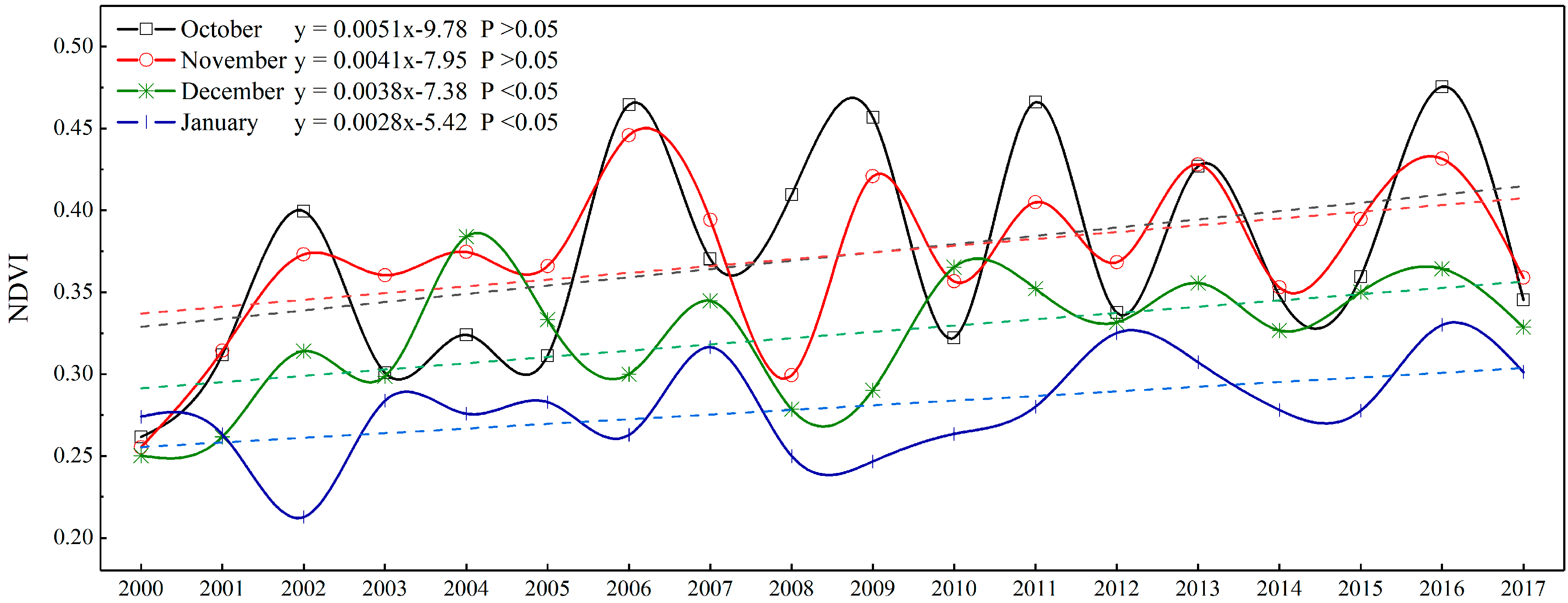
3.1.2. Inter-Monthly Dynamics

According to the statistics of monthly NDVI during wintering seasons, the multi-year mean NDVI in October, November, December, and January of the following year were 0.371, 0.373, 0.324, and 0.280, respectively (Figure 3). The maximum monthly average NDVI in the study area generally occurred in November, followed by October, December, and January. Among them, the trends of monthly mean NDVI in October and November were similar and fluctuated greatly. The trends were consistent to the interannual variations in NDVI with two apparent stages (Figure 2). The study also indicated a steady increase in the monthly mean NDVI in October and January during the past decades.

3.2. Spatial Analysis of Vegetation Variation

3.2.1. Spatial Trend Analysis

The trend analysis of annual mean NDVI reflected the spatial pattern of vegetation dynamics in the study area over the past 18 years. Among them, the area of vegetation exhibiting improvement was 956.5 km2, accounting for 52.81% of the total wetland. The area of obvious improvement in vegetation was much larger than that of moderate improvement and slight improvement (Figure 4). Generally, the improvement regions were mainly distributed in the mudflat wetlands and grassland wetlands adjacent to the water body of the wetland. The total area of vegetation degradation is about 120.6 km2, accounting for 6.66% of the study region. The distribution is relatively scattered, with the most degraded areas lying in the reed wetland near the Luhu Lake and the Chunfeng Lake. In the wintering season, reed harvesting led to a decrease of the NDVI and the degradation of vegetation. The area of land with basically unchanged vegetation is 734.0 km2, accounting for 44.53% of the total area. It is mainly concentrated in the water and grassland wetland away from the central water body. Overall, vegetation of the East Dongting Lake wetland improved substantially from 2000 to 2018.

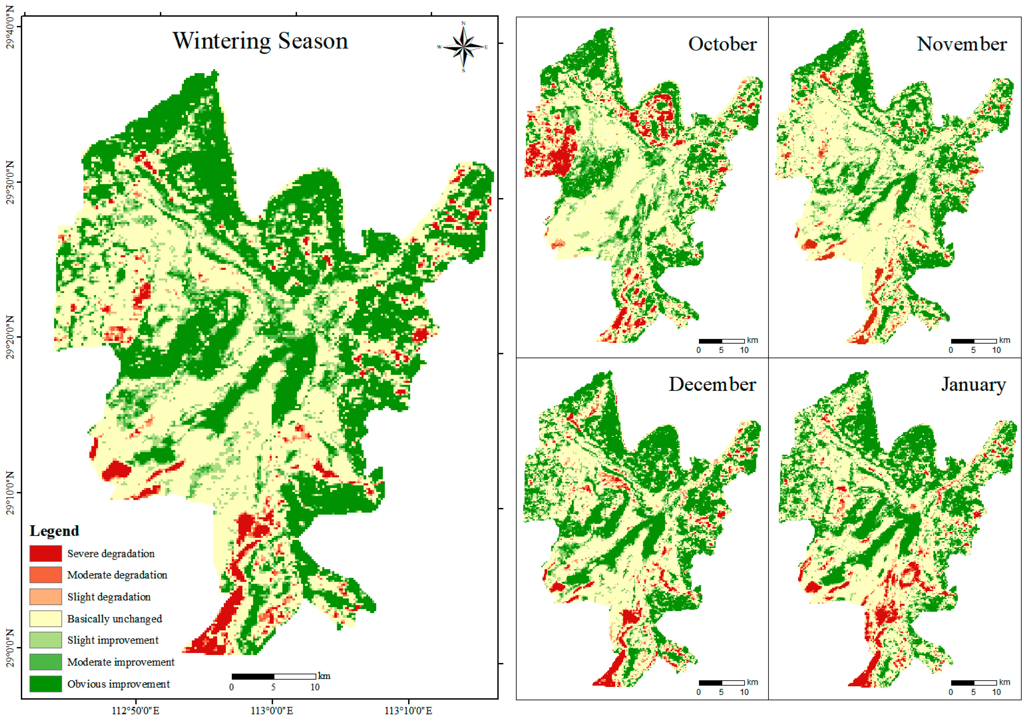
3.2.2. Stability Analysis

Using the stability analysis method, the variation coefficients of the seasonal and monthly mean NDVI at the East Dongting Lake wetland between 2000 and 2018 were examined. On the annual time scale, the area proportion of the variation coefficient greater than 0.10 was 79.61% (Figure 5), which was concentrated in the central water body, mudflat wetland, and grassland wetland close to water. The aquatic vegetation in these parts of the region changed greatly and had poor stability. The variation coefficient showed a decreasing pattern from the central water body to surrounding areas. The variation coefficient of 0 to 0.10 accounted for 20.39% of the study area, concentrated in the grassy marshes far away from the central water body. It showed that in the past 18 years, the stability of vegetation NDVI in only a few areas at the East Dongting Lake wetland has improved significantly.
In terms of monthly time scale, the stability of NDVI in the East Dongting Lake wetland was significantly different over the four months. During the past 18 years, the area proportions with NDVI variation coefficient less than 0.10 were 9.58% in October, 3.80% in November, 1.66% in December, and 0.90% in January. The areas with an NDVI variation coefficient larger than 0.20 were 58.99% in October, 57.69% in November, 63.66% in December, and 64.32% in January, respectively.

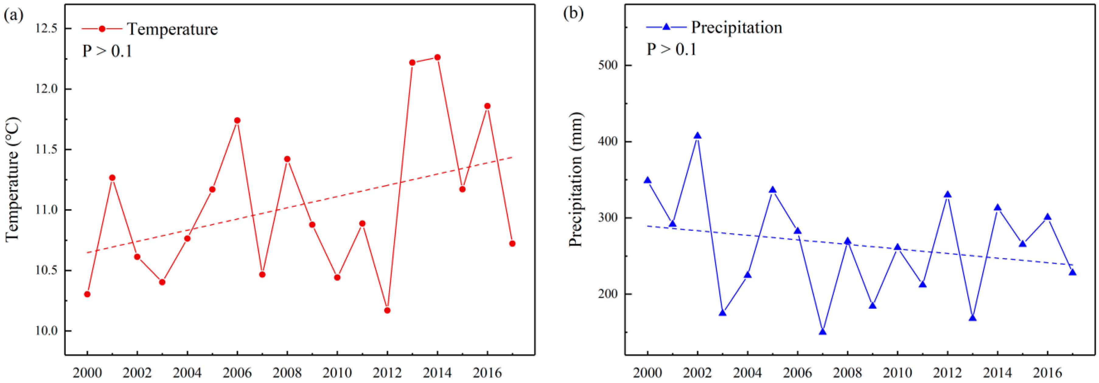
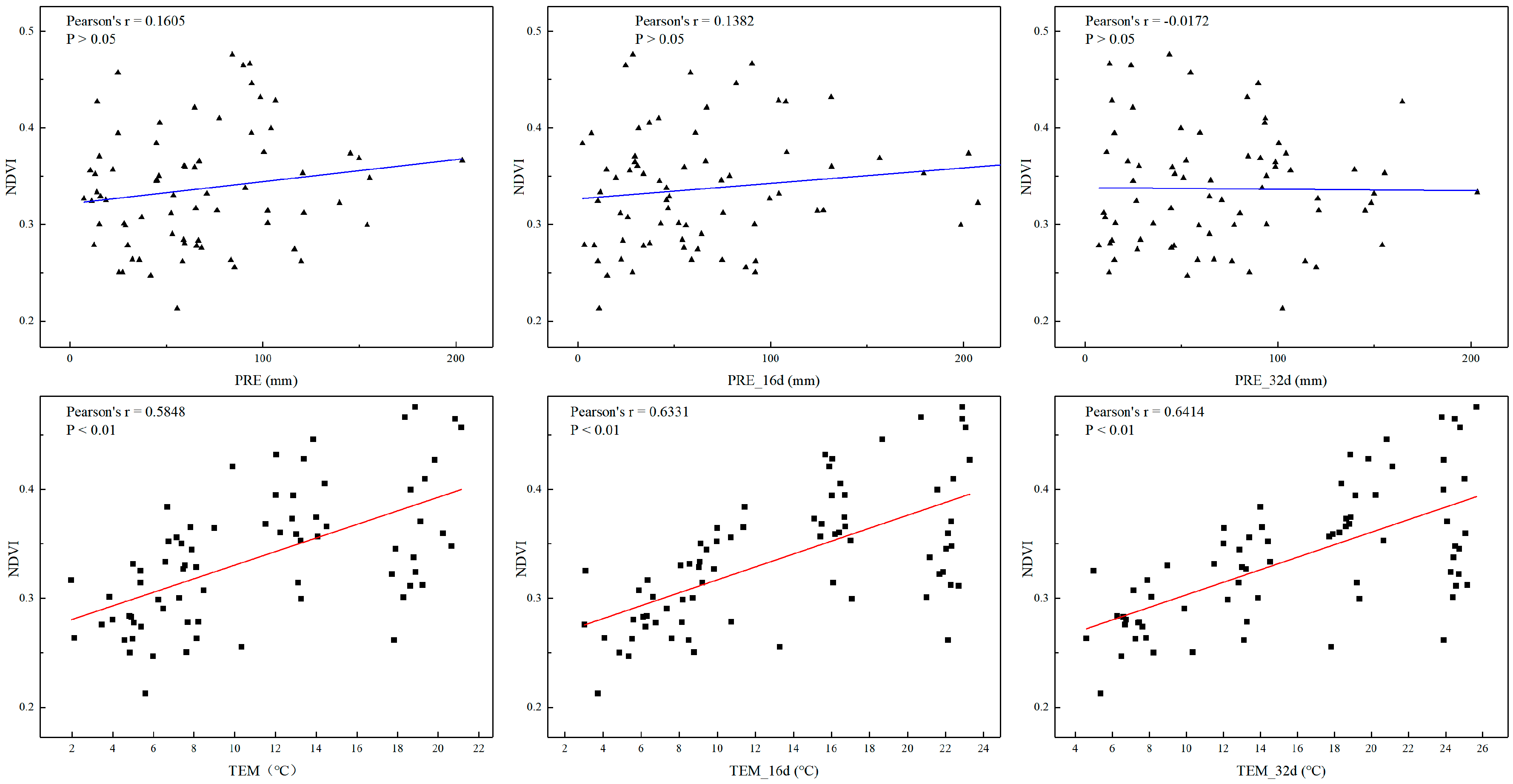
3.3. Effect of Climate Factors on Vegetation Dynamics

Climate change plays an important role in dominating the growth of wetland vegetation. The multi-year mean temperature in the East Dongting Lake wetland during the wintering season is 11.04 ℃. The temperature showed an upward trend, despite fluctuations from October 2003 to January 2013 (Figure 6). Especially, the temperature increased obviously from 2012 to 2013 by about 2 ℃ in magnitude, which was attributed to the abnormal cold weather in the winter of 2012 in China. The hydrological recharge effect after precipitation forms surface runoff and its contribution to the hydrological cycle also affects the distribution and function of wetlands. The accumulated precipitation in the East Dongting Lake wetland during the wintering season presents an obvious fluctuating trend, with a multi-year mean value of 263.72 mm. The precipitation reached a peak in 2002, with 407.43 mm, followed by 2005 with 336.18 mm and 2012 with 330.20 mm.
After analyzing the dynamics in the temperature and precipitation during the past decades, this study analyzed the correlations between the monthly mean vegetation NDVI and the associated meteorological factors. The effects of climate controls were also examined at a 16-d lag and a 32-d lag. Temperature generally exhibited a strong and positive relationship with the variability in NDVI. Especially, the correlation coefficient between the monthly average NDVI and a lag of 32 d in temperature reached a peak of 0.6414 (Figure 7). Generally, the precipitation showed no significant correlations with the monthly mean NDVI. All analyses showed that compared with precipitation, the variability in NDVI was more significantly correlated with temperature, which is the dominant factor controlling the vegetation growth in the East Dongting Lake wetland during the wintering periods.

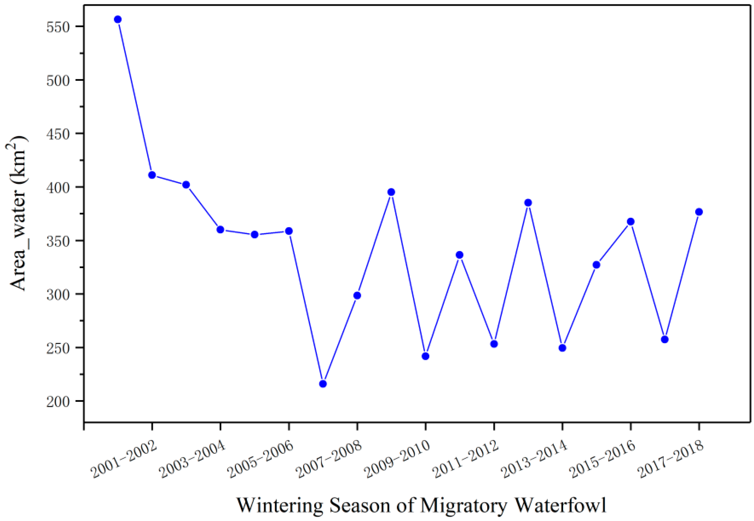
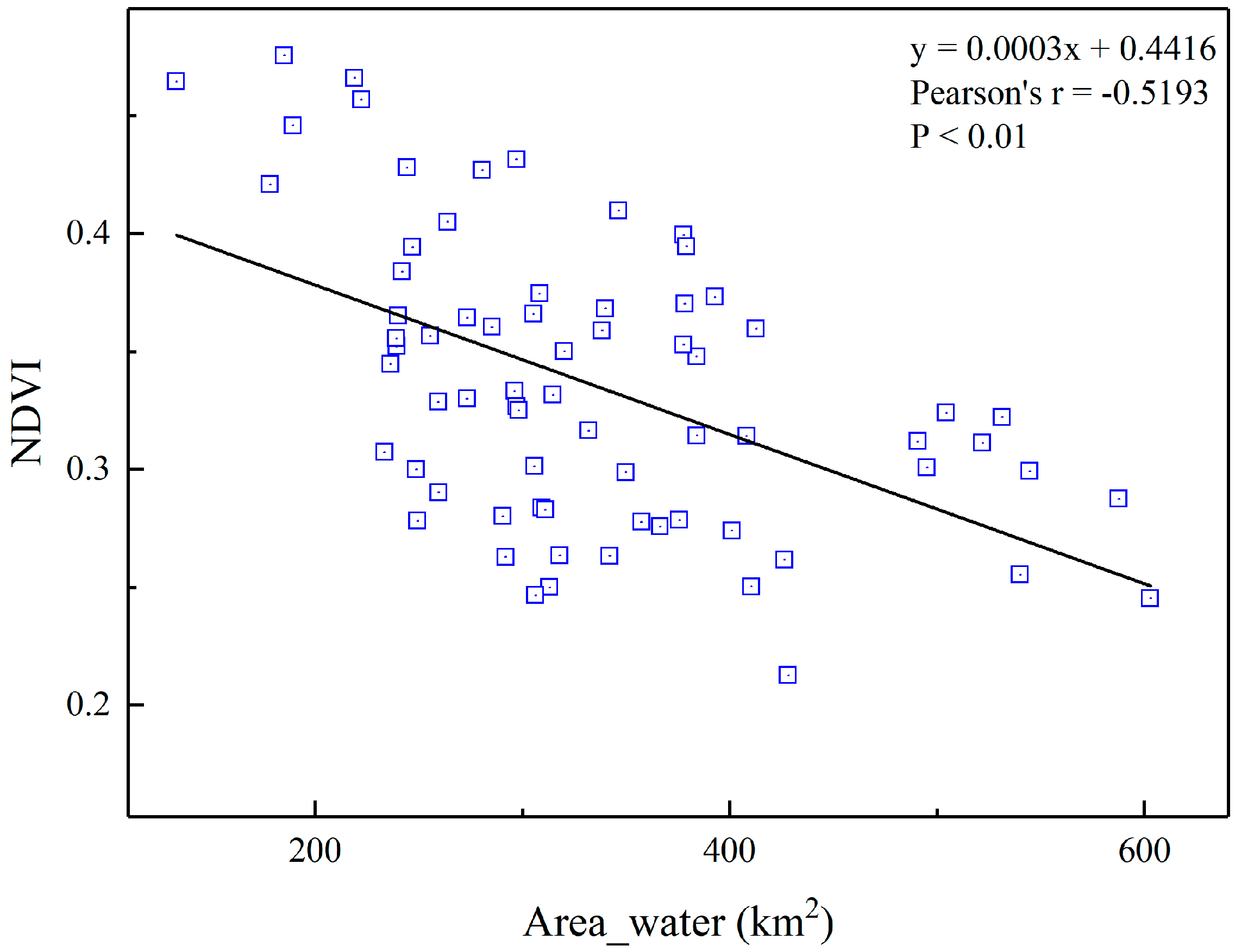
3.4. Effects of Hydrological Regime on Vegetation Dynamics

Over the past 18 years, the water area varied from 216 to 395 km2 during the wintering season at the East Dongting Lake wetland (Figure 8). It showed a significant decreasing trend from the wintering season of 2000 to 2003. This trend ended in 2004 but fell again in 2006. Since then, the water area has fluctuated with remarkable regularity. After the operation of the TGD in 2003, the sediments of the reservoir alleviated the shrinkage of East Dongting Lake. The water area of the East Dongting Lake decreased significantly in the wintering season of 2003, 2006, and 2009. During these years, the TGD experienced important water storage. The water area of the river-communicating lake in the middle and lower reaches of the Yangtze River, such as the East Dongting Lake, decreased significantly during the water storage period. In addition, the unprecedented drought events in 2011 and 2013 reduced the water area of East Dongting Lake.
The effects of hydrologibal conditions on wetland vegetation are presented in Figure 9. The variability in NDVI at the East Dongting Lake wetland showed a significant negative correlation with the water area. The shrinking lake area, in turn, increased the area of exposed mudflat wetlands and grassland wetlands. In addition, vegetated areas, such as the Carex, expanded, with increasing vegetation coverage. Conversely, when the water area increased, the lake area expanded, leading to more areas close to the water body being submerged, which was adverse for the vegetation growth for wintering waterfowls.

4. Discussion

4.1. Vegetation Response to Environmental Controls

Vegetation dynamics are affected by a variety of environmental factors. Climate change is generally recognized as the decisive factor dominating vegetation patterns. Among all the meteorological factors, vegetation is especially sensitive to temperature and precipitation [48]. In the East Dongting Lake wetland, temperature plays a leading role in the vegetation growth during the wintering period for waterfowls. When the temperature is low, vegetation growth will be inhibited. Precipitation decreases in the wintering season, but still meets the water consumption required for the normal growth of vegetation in wetland, thus contributing to the persistent high level of NDVI. Previous studies have pointed out that many environmental factors affected the East Dongting Lake wetland in the past decades, but the specific response to temperature and precipitation usually has a certain time lag [49,50], which is also reflected in the results of this study. October is the beginning of the wintering season, and the temperature is relatively suitable for vegetation growth. However, due to the lagging response of vegetation to climate, the vegetation coverage in the study area in November is better than that in October. After November, the vegetation enters a recession, but the reduction in vegetation coverage in the late wintering season decreases slightly. The vegetation types in the East Dongting Lake wetland are mainly Carex, Artemisia, and Reed, and the growth of these hygrophytes is less affected by precipitation due to their plant habits and growth rules [51]. Climate change will reduce or even eliminate the range of some wetland plants and expand the range of others. Future research should strengthen the comparative study of climate scenario improvement and different methods, strengthen the test of prediction methods, and carry out research on the response of plant species diversity and richness to climate change, so as to formulate more-resilient strategies for sustainable development.
However, the driving factors for changes in vegetation include solar radiation, human activities, and extreme climate [52]. In 2016, the El Niño phenomenon was strong. Due to warming of the ocean, the winter winds weakened, so the East Dongting Lake showed signs of a warm winter [53], which will be conducive to the growth of vegetation and the overwintering of waterfowl. At the same time, the water area of East Dongting Lake in the wintering season of 2016 is smaller than that of 2015 and 2017. The decrease of the water area provides more growth space for wetland vegetation, such as Carex, so the NDVI in the wintering season of 2016 was apparently higher than that in the winters of 2015 and 2017.
In addition, extensive disturbances from human activities, such as ecological protection measures and the construction of hydroelectric dams, have exerted severe impacts on the hydrological regimes, as well as vegetation dynamics, in the East Dongting Lake region [30]. Natural subsidence and ecological protection policies, such as returning farmland to lakes [54], led to a significant increase in vegetation cover between 2000 and 2002. The TGD is a dominant factor affecting the water conditions in the East Dongting Lake and the middle and lower reaches of the Yangtze River, which plays an important role in the trends of vegetation over different years. The TGD begins to store water in October, and the whole impoundment process takes about two months through to early December. During the storage period in October and November, the NDVI trend change is basically the same, and the water level in the lake area decreases rapidly. The water area decreases, and the large area of exposed mudflat quickly develops into grassy marshes. Therefore, the monthly average NDVI in October and November is larger than that in the other two months, and with the increase of the water storage time, the monthly average NDVI in November is slightly larger than that in October. Falling water levels in early October expose sedge meadows and allow them to rapidly grow, providing a major food source for wintering waterfowls when they arrive to the wetland.

4.2. Potential Effects on Waterfowl Populations

During the wintering seasons in past decades, the number of migratory birds in the East Dongting Lake wetland showed a cyclical change from a decline to a rise, with an overall upward trend (Figure 10). The policy of returning farmland to lake has enabled typical wetland plants to replace the original artificial crops. This has not only attracted more migratory birds but also made the wetland area of East Dongting Lake larger. This process directly provided more habitats for wild waterfowls and thus increased their quantity. After impoundment of the TGD, the sediment transport volume dropped sharply [55,56], the amount of sediment entering the lake decreased, and the area of the East Dongting Lake wetland increased. It also indirectly attracted more wetland waterfowl. In recent years, the implementation of many measures to protect waterfowl in the East Dongting Lake wetland is another reason for their proliferation.
In the winters of 2006 and 2011, the East Dongting Lake wetland experienced severe droughts. The wetland waterfowl populations were obviously affected in January 2007 and January 2012. In January 2007, the water area decreased by 19.13 km2 compared with January 2006, and in January 2012, the water area decreased by 83.08 km2 compared with January 2011. Thus, it can be concluded that the East Dongting Lake was severely disturbed by extreme weather events. Drought also occurred in 2009, but the number of waterfowl still increased in the second year. The specific reason may be that the drought in 2009 was not as serious as those hitherto mentioned and ended in January 2010. The number of waterfowl in the wetland in January 2013 was basically the same as that recorded in January 2012. Because the drought in 2011 was severe and its impacts lasted until January 2013, another severe spring drought in 2014 made the number of migratory birds in the East Dongting Lake wetland plummet once more. Thankfully, the number of wintering waterfowl in the wetland has gradually increased, reaching a maximum in January 2018.
Previous studies found that wintering waterfowl exhibited spatio-temporal variations in distribution, abundance, richness and diversity, and composition. Such variations are not only influenced by internal factors of species characteristics, such as feeding habits and individual development, but also driven by the wetland habitat quality in the East Dongting Lake [57,58,59]. This paper primarily discussed the temporal and spatial dynamic changes of wetland vegetation and its impact on waterfowl during the wintering period. In previous studies on wetland waterfowls, environmental factors mainly included vegetation cover [60,61], sunshine [62], rainfall [33], hydrological regime [63,64,65], food availability, and human disturbance [66,67]. The impact of environmental factors on waterfowls may be significantly different among species. Such concerns do, however, lie beyond the scope of this paper. However, in the East Dongting Lake wetland, the wintering waterfowl are predominantly comprised of Anseriformes, while the water regime and food resource are considered to be the most important factors affecting the distribution and quantity of waterfowls in wintering periods. The herbivorous Anseriformes feed on recessional short grassland and sedge meadows as food resources. Thus, study on the vegetation dynamics and its driving factors during wintering seasons is of great significance to the suitability evaluation for waterfowl habitats.

5. Conclusions

Wetland ecosystems comprise a whole interaction between the biological environment and the non-biological environment. Meanwhile, the impact of human activities on wetland ecosystems cannot be ignored, which exert severe effects on the wildlife and biodiversity, especially with rapid development of the economy. This paper used the long-term sequence of remote sensing data to objectively analyze vegetation dynamics during the wintering period of waterfowls in the East Dongting Lake wetland. The results showed that in the past decades, the NDVI of the protected area exhibited an overall increasing trend during wintering seasons, which indicated more suitable habitats can be provided for wintering waterfowls. We also found that the NDVI in November reached the maximum value, which is relevant to the quantity of wintering waterfowls because the well-growing vegetation provides sufficient food resources and favorable shelter. In addition, the NDVI in wintering seasons exhibited lagging effects of temperature responses. This study revealed that the variability in the NDVI during wintering periods is mainly altered by the water conditions. Such research on the impact of environmental controls on vegetation in the reserve can, therefore, provide scientific support for improving the suitability of waterfowl habitats during winter and maintaining the stability of wetland ecosystems.

Author Contributions

M.W. analyzed the data and wrote the manuscript. Q.G., J.S. and G.L. helped to review and revise the manuscript. X.T. designed and J.S. supported the study.

Funding

The study was jointly supported by the National Natural Science Foundation in China (41961004), the Fundamental Research Funds for the Central Universities (XDJK2019B008), Chongqing Basic and Frontier Research Program (cstc2018jcyjAX0056) and the Innovative Research Program for Graduates of Chongqing (CYS19074). The meteorological dataset is shared by the Data Center for Resources and Environmental Sciences, Chinese Academy of Sciences (RESDC). We are also grateful to the Distributed Active Archive Center of the Oak Ridge National Laboratory, and the Earth Observing System Data for making these MODIS products available. Thanks to Bertie Dockerill in the University of Liverpool for commenting on an early draft of this paper. The East Dongting Lake Natural Reserve administration provided us the valuable data of wintering waterfowls.

Conflicts of Interest

The authors declare no conflict of interest.

References

  1. Withey, P.; Van Kooten, G.C. The effect of climate change on optimal wetlands and waterfowl management in Western Canada. Ecol. Econ. 2011, 70, 798–805. [Google Scholar] [CrossRef]
  2. Zhiqiang, T.; Qi, Z.; Mengfan, L.; Yunliang, L.; Xiuli, X.; Jiahu, J. A study of the relationship between wetland vegetation communities and water regimes using a combined remote sensing and hydraulic modeling approach. Hydrol. Res. 2016, 47, 278–292. [Google Scholar] [CrossRef] [Green Version]
  3. Fu, W.; Li, P.; Wu, Y. Mechanism of the plant community succession process in the Zhenjiang Waterfront Wetland. Plant Ecol. 2011, 212, 1339–1347. [Google Scholar] [CrossRef]
  4. Palanisamy, B.; Chui, T.F.M. Understanding wetland plant dynamics in response to water table changes through ecohydrological modelling. Ecohydrology 2013, 6, 287–296. [Google Scholar] [CrossRef]
  5. Celdrán, P.F.; Aymerich, F.R. Structure and Distribution of the Waterbird Community in the Mar Menor Coastal Lagoon (SE Spain) and Relationships with Environmental Gradients. Waterbirds 2010, 33, 479–494. [Google Scholar] [CrossRef]
  6. Paillisson, J.-M.; Reeber, S.; Marion, L. Bird assemblages as bio-indicators of water regime management and hunting disturbance in natural wet grasslands. Boil. Conserv. 2002, 106, 115–127. [Google Scholar] [CrossRef]
  7. Lyon, J.G.; McCarthy, J. Wetland and Environmental Applications of GIS; CRC Press: Boca Raton, FL, USA, 1995. [Google Scholar]
  8. Shaikh, M.; Green, D.; Cross, H. A remote sensing approach to determine environmental flows for wetlands of the Lower Darling River, New South Wales, Australia. Int. J. Remote. Sens. 2001, 22, 1737–1751. [Google Scholar] [CrossRef]
  9. Ozesmi, S.L.; Bauer, M.E. Satellite remote sensing of wetlands. Wetl. Ecol. Manag. 2002, 10, 381–402. [Google Scholar] [CrossRef]
  10. Seto, K.C.; Fleishman, E.; Fay, J.P.; Betrus, C.J. Linking spatial patterns of bird and butterfly species richness with Landsat TM derived NDVI. Int. J. Remote. Sens. 2004, 25, 4309–4324. [Google Scholar] [CrossRef]
  11. Zu-Kui, L.; Zhang, W.-H.; Hou, Y.; Li, X.-Y.; Liu, W.; Li, Z.-J. Seasonal dynamics and habitat selection of Ruddy Shelduck (Tadorna ferruginea) (Anseriformes: Anatidae) in alpine wetland ecosystem of Southwest China. Acta Zool. Bulg. 2013, 65, 469–478. [Google Scholar]
  12. Liang, J.; Hua, S.; Zeng, G.; Yuan, Y.; Lai, X.; Li, X.; Li, F.; Wu, H.; Huang, L.; Yu, X. Application of weight method based on canonical correspondence analysis for assessment of Anatidae habitat suitability: A case study in East Dongting Lake, Middle China. Ecol. Eng. 2015, 77, 119–126. [Google Scholar] [CrossRef]
  13. Cao, L.; Barter, M.; Lei, G. New Anatidae population estimates for eastern China: Implications for current flyway estimates. Boil. Conserv. 2008, 141, 2301–2309. [Google Scholar] [CrossRef]
  14. Mistry, J.; Berardi, A.; Simpson, M. Birds as indicators of wetland status and change in the North Rupununi, Guyana. Biodivers. Conserv. 2008, 17, 2383–2409. [Google Scholar] [CrossRef] [Green Version]
  15. Meehan, T.D.; Hurlbert, A.H.; Gratton, C. Bird communities in future bioenergy landscapes of the Upper Midwest. Proc. Natl. Acad. Sci. USA 2010, 107, 18533–18538. [Google Scholar] [CrossRef] [PubMed] [Green Version]
  16. Szostek, K.L.; Becker, P.H. Survival and local recruitment are driven by environmental carry-over effects from the wintering area in a migratory seabird. Oecologia 2015, 178, 643–657. [Google Scholar] [CrossRef] [PubMed]
  17. Durant, D.; Fritz, H.; Duncan, P. Feeding patch selection by herbivorous Anatidae: The influence of body size, and of plant quantity and quality. J. Avian Boil. 2004, 35, 144–152. [Google Scholar] [CrossRef]
  18. Si, Y.; Skidmore, A.K.; Wang, T.; de Boer, W.F.; Toxopeus, A.G.; Schlerf, M.; Oudshoorn, M.; Zwerver, S.; van der Jeugd, H.; Exo, K.-M. Distribution of Barnacle Geese Branta leucopsis in relation to food resources, distance to roosts, and the location of refuges. Ardea 2011, 99, 217–226. [Google Scholar] [CrossRef]
  19. Gan, X.; Choi, C.Y.; Wang, Y.; Ma, Z.; Chen, J.; Li, B. Alteration of Habitat Structure and Food Resources by Invasive Smooth Cordgrass Affects Habitat Use by Wintering Saltmarsh Birds at Chongming Dongtan, East China. Auk 2010, 127, 317–327. [Google Scholar] [CrossRef]
  20. Rajashekara, S.; Venkatesha, M. Eco-spatial and temporal variation in waterbirds composition and their relationship with habitat characteristics of Urban Lakes of Bengaluru city, India. Int. J. Adv. Res. 2014, 2, 60–80. [Google Scholar]
  21. Cardoni, D.; Favero, M.; Isacch, J. Recreational activities affecting the habitat use by birds in Pampa’s wetlands, Argentina: Implications for waterbird conservation. Boil. Conserv. 2008, 141, 797–806. [Google Scholar] [CrossRef]
  22. Zhao, M.; Cao, L.; Klaassen, M.; Zhang, Y.; Fox, A.D. Avoiding Competition? Site Use, Diet and Foraging Behaviours in Two Similarly Sized Geese Wintering in China. Ardea 2015, 103, 27–39. [Google Scholar] [CrossRef]
  23. Dronova, I.; Beissinger, S.R.; Burnham, J.W.; Gong, P. Landscape-Level Associations of Wintering Waterbird Diversity and Abundance from Remotely Sensed Wetland Characteristics of Poyang Lake. Remote. Sens. 2016, 8, 462. [Google Scholar] [CrossRef]
  24. Xia, S.; Liu, Y.; Chen, B.; Jia, Y.; Zhang, H.; Liu, G.; Yu, X. Effect of water level fluctuations on wintering goose abundance in Poyang Lake wetlands of China. Chin. Geogr. Sci. 2017, 27, 248–258. [Google Scholar] [CrossRef]
  25. Fang, J.; Wang, Z.; Zhao, S.; Li, Y.; Tang, Z.; Yu, D.; Ni, L.; Liu, H.; Xie, P.; Da, L.; et al. Biodiversity changes in the lakes of the Central Yangtze. Front. Ecol. Environ. 2006, 4, 369–377. [Google Scholar] [CrossRef]
  26. David, S.; Qiaoli, L. Landscape changes and increasing flood frequency in China’s Lake Poyang Region. Prof. Geogr. 2003, 55, 434–445. [Google Scholar]
  27. He, Y.; Zhang, M.-X. Study on wetland loss and its reasons in China. Chin. Geogr. Sci. 2001, 11, 241–245. [Google Scholar] [CrossRef]
  28. Dai, M.; Wang, J.; Zhang, M.; Chen, X. Impact of the Three Gorges Project operation on the water exchange between Dongting Lake and the Yangtze River. Int. J. Sedim. Res. 2017, 32, 506–514. [Google Scholar] [CrossRef]
  29. Lu, C.; Jia, Y.; Jing, L.; Zeng, Q.; Lei, J.; Zhang, S.; Lei, G.; Wen, L. Shifts in river-floodplain relationship reveal the impacts of river regulation: A case study of Dongting Lake in China. J. Hydrol. 2018, 559, 932–941. [Google Scholar] [CrossRef]
  30. Xie, Y.H.; Yue, T.; Xin-sheng, C.; Feng, L.; Zheng-miao, D. The impact of Three Gorges Dam on the downstream eco-hydrological environment and vegetation distribution of East Dongting Lake. Ecohydrology 2015, 8, 738–746. [Google Scholar] [CrossRef]
  31. Yuan, Y.; Zeng, G.; Liang, J.; Huang, L.; Hua, S.; Li, F.; Zhu, Y.; Wu, H.; Liu, J.; He, X.; et al. Variation of water level in Dongting Lake over a 50-year period: Implications for the impacts of anthropogenic and climatic factors. J. Hydrol. 2015, 525, 450–456. [Google Scholar] [CrossRef]
  32. Wang, X.; Fox, A.D.; Cong, P.; Cao, L. Food constraints explain the restricted distribution of wintering Lesser White-fronted Geese Anser erythropus in China. IBIS 2013, 155, 576–592. [Google Scholar] [CrossRef]
  33. Zhang, C.; Yuan, Y.; Zeng, G.; Liang, J.; Guo, S.; Huang, L.; Hua, S.; Wu, H.; Zhu, Y.; An, H.; et al. Influence of hydrological regime and climatic factor on waterbird abundance in Dongting Lake Wetland, China: Implications for biological conservation. Ecol. Eng. 2016, 90, 473–481. [Google Scholar] [CrossRef]
  34. Zhang, P.; Zou, Y.; Xie, Y.; Zhang, H.; Liu, X.; Gao, D.; Yi, F. Shifts in distribution of herbivorous geese relative to hydrological variation in East Dongting Lake wetland, China. Sci. Total. Environ. 2018, 636, 30–38. [Google Scholar] [CrossRef] [PubMed]
  35. Zou, Y.-A.; Tang, Y.; Xie, Y.-H.; Zhao, Q.-H.; Zhang, H. Response of herbivorous geese to wintering habitat changes: Conservation insights from long-term population monitoring in the East Dongting Lake, China. Reg. Environ. Chang. 2017, 17, 879–888. [Google Scholar] [CrossRef]
  36. Harrison, N.; Whitehouse, M. Drivers of songbird productivity at a restored gravel pit: Influence of seasonal flooding and rainfall patterns and implications for habitat management. Agric. Ecosyst. Environ. 2012, 162, 138–143. [Google Scholar] [CrossRef]
  37. Reid, J.R.; Colloff, M.J.; Arthur, A.D.; McGinness, H.M. Influence of Catchment Condition and water resource development on waterbird assemblages in the Murray-Darling Basin, Australia. Boil. Conserv. 2013, 165, 25–34. [Google Scholar] [CrossRef]
  38. Tang, X.; Li, H.; Xu, X.; Yang, G.; Liu, G.; Li, X.; Chen, D. Changing land use and its impact on the habitat suitability for wintering Anseriformes in China’s Poyang Lake region. Sci. Total Environ. 2016, 557, 296–306. [Google Scholar] [CrossRef]
  39. Norris, D.R.; Marra, P.P.; Kyser, T.K.; Sherry, T.W.; Ratcliffe, L.M. Tropical winter habitat limits reproductive success on the temperate breeding grounds in a migratory bird. Proc. R. Soc. Lond. Ser. B Biol. Sci. 2004, 271, 59–64. [Google Scholar] [CrossRef] [Green Version]
  40. Li, F.; Huang, J.; Zeng, G.; Yuan, X.; Li, X.; Liang, J.; Wang, X.; Tang, X.; Bai, B. Spatial risk assessment and sources identification of heavy metals in surface sediments from the Dongting Lake, Middle China. J. Geochem. Explor. 2013, 132, 75–83. [Google Scholar] [CrossRef]
  41. Shankman, D.; Keim, B.D.; Song, J. Flood frequency in China’s Poyang Lake region: Trends and teleconnections. Int. J. Clim. 2006, 26, 1255–1266. [Google Scholar] [CrossRef]
  42. Hui, F.; Xu, B.; Huang, H.; Yu, Q.; Gong, P. Modelling spatial-temporal change of Poyang Lake using multitemporal Landsat imagery. Int. J. Remote. Sens. 2008, 29, 5767–5784. [Google Scholar] [CrossRef]
  43. Guan, L.; Lei, J.; Zuo, A.; Zhang, H.; Lei, G.; Wen, L. Optimizing the timing of water level recession for conservation of wintering geese in Dongting Lake, China. Ecol. Eng. 2016, 88, 90–98. [Google Scholar] [CrossRef]
  44. Wang, X.; Zhang, Y.; Zhao, M.; Cao, L.; Fox, A.D. The benefits of being big: Effects of body size on energy budgets of three wintering goose species grazing Carex beds in the Yangtze River floodplain, China. J. Ornithol. 2013, 154, 1095–1103. [Google Scholar] [CrossRef]
  45. Li, Z.; Chen, Y.; Li, W.; Deng, H.; Fang, G. Potential impacts of climate change on vegetation dynamics in Central Asia. J. Geophys. Res. Atmos. 2015, 120, 12345–12356. [Google Scholar] [CrossRef]
  46. He, Y.; Fan, G.; Zhang, X.; Li, Z.; Gao, D. Vegetation phenological variation and its response to climate changes in Zhejiang province. J. Nat. Resour. 2013, 2, 220–233. [Google Scholar]
  47. Wang, Y.; Shen, Y.; Chen, Y.; Ying, G. Vegetation dynamics and their response to hydroclimatic factors in the Tarim River Basin, China. Ecohydrology 2013, 6, 927–936. [Google Scholar] [CrossRef]
  48. Bing, L.X.; Shi, P.J. Sensitivity analysis of variation in ndvi, temperature and precipitation in typical vegetation types across china. Acta Phytoecol. Sin. 2000, 31, 987–994. [Google Scholar]
  49. Wu, D.; Zhao, X.; Liang, S.; Zhou, T.; Huang, K.; Tang, B.; Zhao, W. Time-lag effects of global vegetation responses to climate change. Glob. Chang. Boil. 2015, 21, 3520–3531. [Google Scholar] [CrossRef]
  50. Chen, X.; Hu, B.; Yu, R. Spatial and temporal variation of phenological growing season and climate change impacts in temperate eastern China. Glob. Chang. Boil. 2005, 11, 1118–1130. [Google Scholar] [CrossRef]
  51. Li, W.; Wang, X.; Pang, Y.W.; Liu, Y.Z.; He, L.; Zhang, H.; Ying, Z.X.; Liu, Y.; Ge, G. Effects of different water depths on the growth and vegetative reproductive characteristics of wetland vegetation in Lake Poyang. Acta Ecol. 2018, 38, 3014–3021. [Google Scholar]
  52. Poiani, K.A.; Johnson, W.C. Global Warming and Prairie Wetlands. Bioscience 1991, 41, 611–618. [Google Scholar] [CrossRef]
  53. Chen, S.; Chen, W.; Wei, K. Recent trends in winter temperature extremes in eastern China and their relationship with the Arctic Oscillation and ENSO. Adv. Atmos. Sci. 2013, 30, 1712–1724. [Google Scholar] [CrossRef]
  54. Li, S.; Yan, J.; Liu, X.; Wan, J. Response of vegetation restoration to climate change and human activities in Shaanxi-Gansu-Ningxia Region. J. Geogr. Sci. 2013, 23, 98–112. [Google Scholar] [CrossRef]
  55. Wang, J.; Guo, W.; Xu, H.T. Research on Sediment Problem in Dam Area of Three Gorges Project; Applied Mechanics and Materials; Trans Tech Publishers: Zurich, Switzerland, 2014; pp. 770–773. [Google Scholar]
  56. Zhang, Q.; Singh, V.P.; Chen, X. Influence of Three Gorges Dam on streamflow and sediment load of the middle Yangtze River, China. Stoch. Environ. Res. Risk Assess. 2012, 26, 569–579. [Google Scholar] [CrossRef]
  57. González-Gajardo, A.; Sepúlveda, P.V.; Schlatter, R. Waterbird Assemblages and Habitat Characteristics in Wetlands: Influence of Temporal Variability on Species-Habitat Relationships. Waterbirds 2009, 32, 225–234. [Google Scholar] [CrossRef]
  58. Johnson, S.R.; Noel, L.E. Temperature and Predation Effects on Abundance and Distribution of Lesser Snow Geese in the Sagavanirktok River Delta, Alaska. Waterbirds 2005, 28, 292–301. [Google Scholar] [CrossRef]
  59. Wang, W.; Fraser, J.D.; Chen, J. Wintering waterbirds in the middle and lower Yangtze River floodplain: Changes in abundance and distribution. Bird Conserv. Int. 2017, 27, 167–186. [Google Scholar] [CrossRef]
  60. Glisson, W.J.; Brady, R.S.; Paulios, A.T.; Jacobi, S.K.; Larkin, D.J. Sensitivity of secretive marsh birds to vegetation condition in natural and restored wetlands in Wisconsin. J. Wildl. Manag. 2015, 79, 1101–1116. [Google Scholar] [CrossRef]
  61. Wu, X.; Lv, M.; Jin, Z.; Michishita, R.; Chen, J.; Tian, H.; Tu, X.; Zhao, H.; Niu, Z.; Chen, X.; et al. Normalized difference vegetation index dynamic and spatiotemporal distribution of migratory birds in the Poyang Lake wetland, China. Ecol. Indic. 2014, 47, 219–230. [Google Scholar] [CrossRef]
  62. Carr, J.M.; Lima, S.L. Wintering birds avoid warm sunshine: Predation and the costs of foraging in sunlight. Oecologia 2014, 174, 713–721. [Google Scholar] [CrossRef]
  63. Yuan, Y.; Zeng, G.; Liang, J.; Li, X.; Li, Z.; Zhang, C.; Huang, L.; Lai, X.; Lu, L.; Wu, H.; et al. Effects of landscape structure, habitat and human disturbance on birds: A case study in East Dongting Lake wetland. Ecol. Eng. 2014, 67, 67–75. [Google Scholar] [CrossRef]
  64. Forcey, G.; Linz, G.; Thogmartin, W.; Bleier, W.; Thogmartin, W. Influence of land use and climate on wetland breeding birds in the Prairie Pothole region of Canada. Can. J. Zoöl. 2007, 85, 421–436. [Google Scholar] [CrossRef] [Green Version]
  65. Causarano, F.; Battisti, C. Effect of seasonal water level decrease on a sensitive bird assemblage in a Mediterranean wetland. Rend. Lincei 2009, 20, 211–218. [Google Scholar] [CrossRef]
  66. Knapton, R.W.; Petrie, S.A.; Herring, G. Human disturbance of diving ducks on Long Point Bay, Lake Erie. Wildl. Soc. Bull. 2000, 28, 923–930. [Google Scholar]
  67. Gill, J.A. Approaches to measuring the effects of human disturbance on birds. IBIS 2007, 149, 9–14. [Google Scholar] [CrossRef]
Figure 1. Geographical location of the East Dongting Lake National Natural Reserve, Hunan Province, People’s Republic of China.
Sustainability 11 04936 g001
Figure 2. The changing trend in the annual mean NDVI of the East Dongting Lake wetland during the wintering seasons between 2000 and 2018.
Sustainability 11 04936 g002
Figure 3. The changing trends in monthly mean NDVI at the East Dongting Lake wetland from 2000 to 2018.
Sustainability 11 04936 g003
Figure 4. Spatial trend analysis of the annual and monthly mean NDVI at the East Dongting Lake wetland during the wintering period from 2000 to 2018.
Sustainability 11 04936 g004
Figure 5. The area proportions of different NDVI stability at the East Dongting Lake wetland from 2000 to 2018.
Sustainability 11 04936 g005
Figure 6. Changes in temperate (a) and precipitation (b) during the wintering period of migratory waterfowl in the East Dongting Lake wetland over the past 18 years.
Sustainability 11 04936 g006
Figure 7. Correlation diagram between the meteorological factors and vegetation NDVI over different lag periods at the East Dongting Lake wetland.
Sustainability 11 04936 g007
Figure 8. Changes in water area during the wintering period of migratory waterfowl in the East Dongting Lake wetland over the past 18 years.
Sustainability 11 04936 g008
Figure 9. Correlation analysis between the water area and vegetation NDVI during the wintering period from 2000 to 2018 at the East Dongting Lake wetland.
Sustainability 11 04936 g009
Figure 10. The populations of wintering waterfowls in January from 2006 to 2018 at the East Dongting Lake wetland.
Sustainability 11 04936 g010

