Influence of Urbanization Processes on the Dynamics and Scale of Spatial Transformations in the Mazowiecki Landscape Park


Abstract
1. Introduction
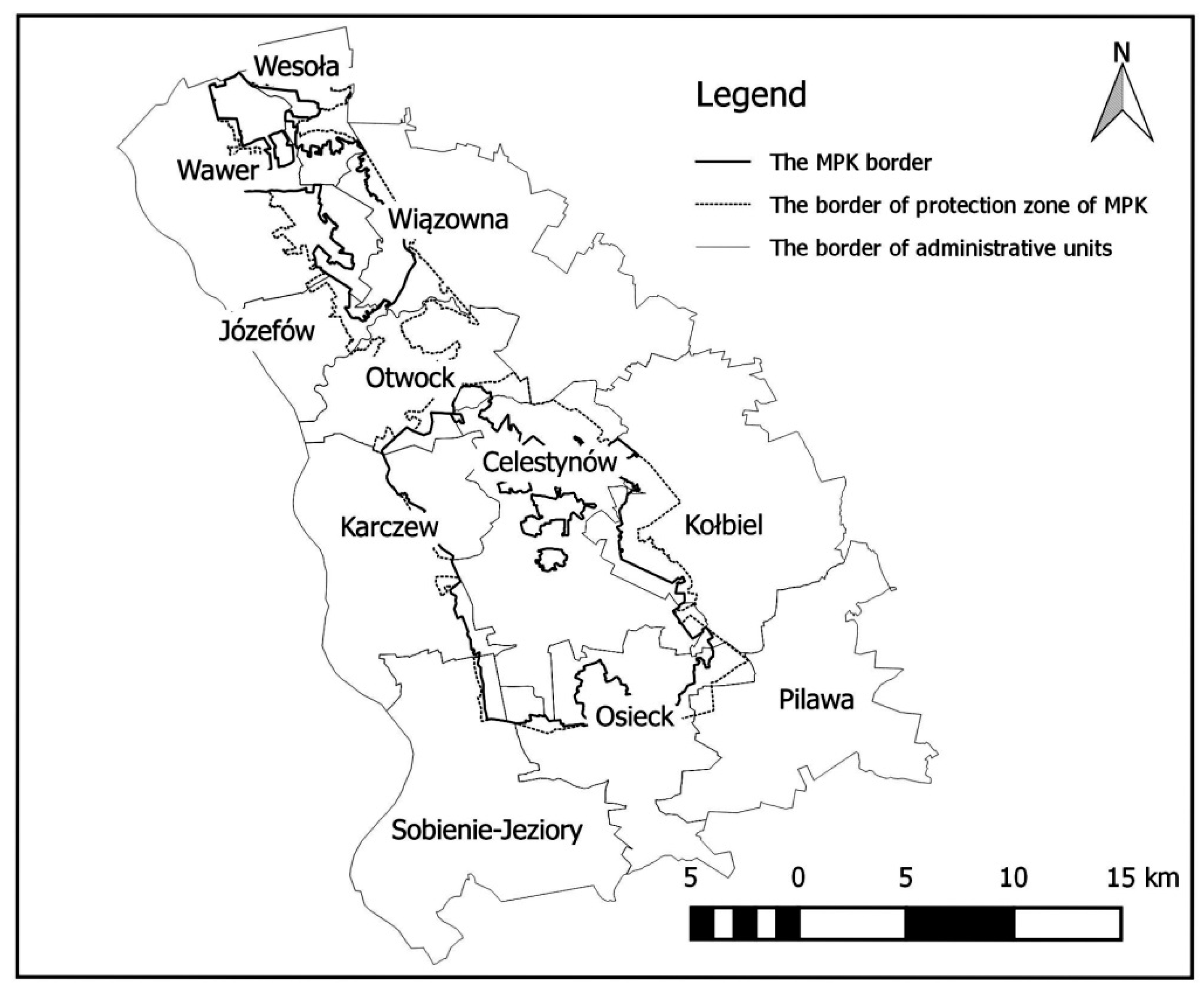
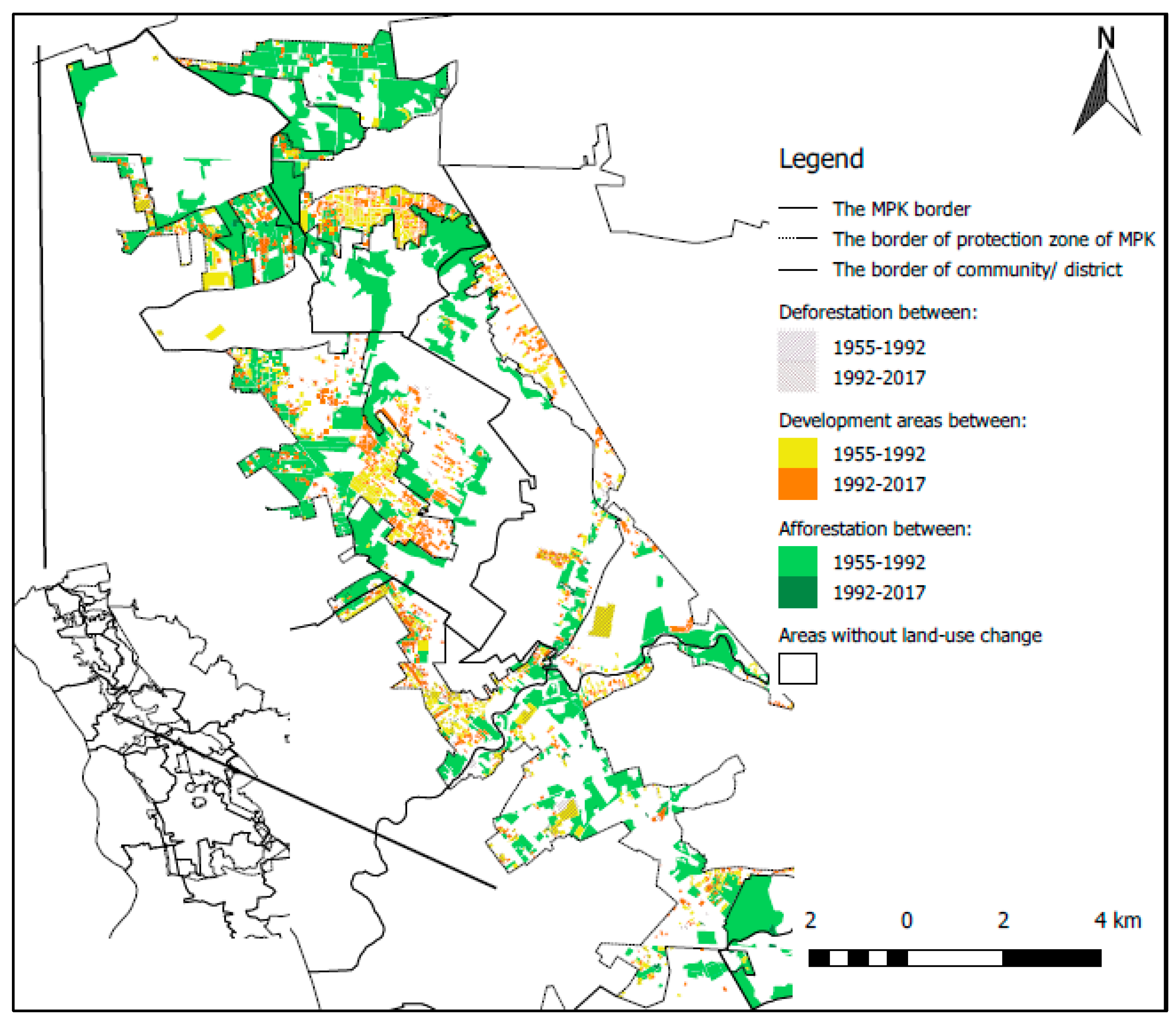
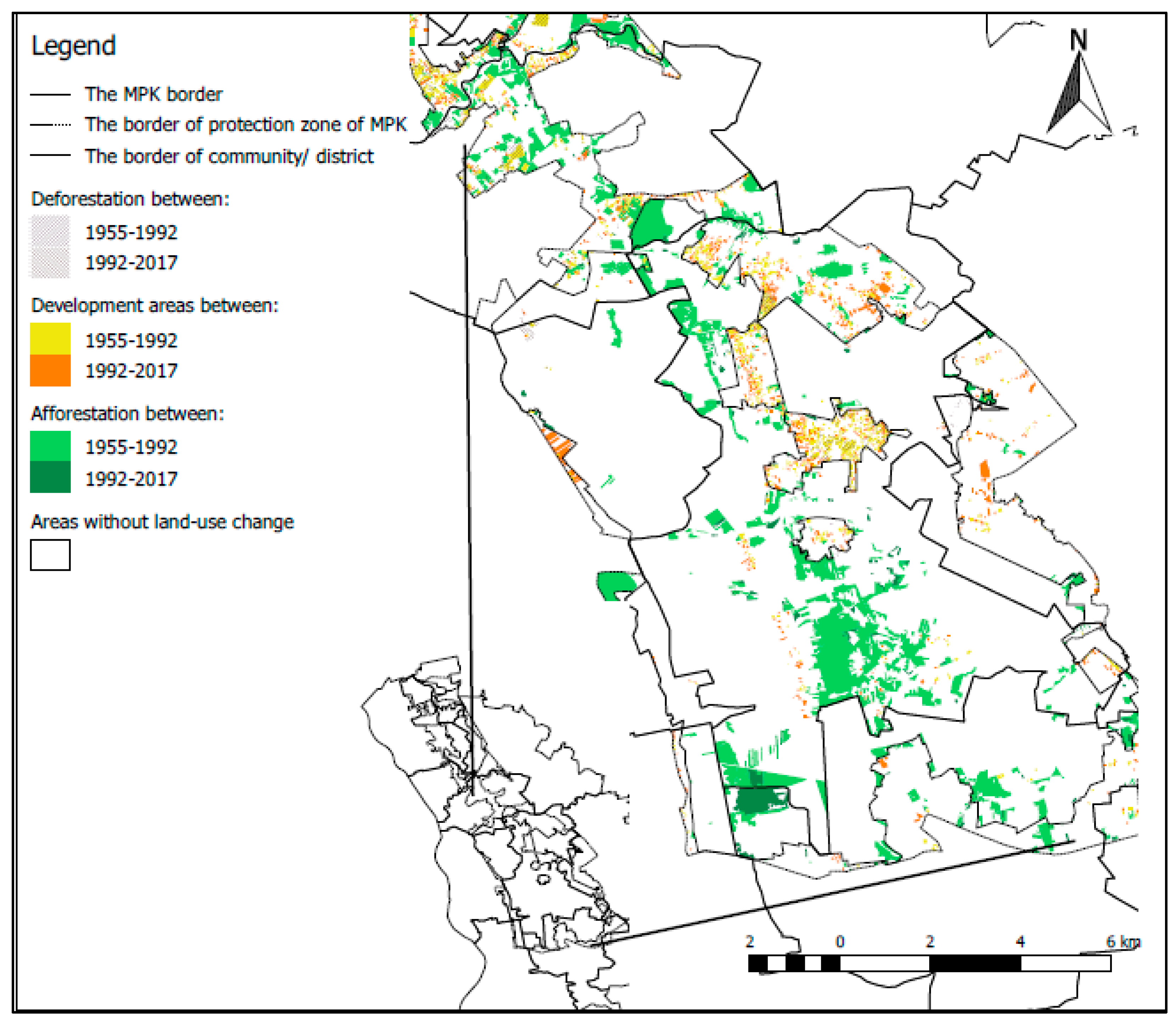
2. Methods
- Analog aerial photographs from 1955–1960, black and white, made vertically (approximately 250 pieces). Photos were taken from the park’s archives.
- Diapositive aerial photos from 1992 in the form of plates—red color, made vertically (approximately 100 pieces). Photos were taken from the park’s archives.
- Ortophotomap from 2010 with real geographical representation, multi-colored, WMS overlays (Web Map System) with a current land and building register (as of December 2017).
3. Results
4. Discussion
5. Summary
Author Contributions
Funding
Conflicts of Interest
References
- Abass, K.; Adanu, S.K.; Agyemang, S. Periurbanisation and loss of arable land in Kumasi Metropolis in three decades: Evidence from remote sensing image analysis. Land Use Policy 2018, 72, 470–479. [Google Scholar] [CrossRef]
- Hoogstra, M.A.; Schanz, H.; Wiersum, K.F. The future of European forestry—Between urbanization and rural development. For. Policy Econ. 2004, 6, 441–445. [Google Scholar] [CrossRef]
- Konijnendijk, C.C. A decade of urban forestry in Europe. For. Policy Econ. 2003, 5, 173–186. [Google Scholar] [CrossRef]
- Trzyna, T. Global Urbanization and Protected Areas: Challenges and Opportunities Posed by a Major Factor of Global Change- and Creative Ways of Responding; California Institute of Public Affairs: Sacramento, CA, USA, 2007; Available online: http://webdoc.sub.gwdg.de/ebook/mon/2008/ppn%20566501791.pdf (accessed on 10 March 2019).
- Botkin, D.B.; Beverige, C.E. Cities as environments. Urban Ecosyst. 1997, 1, 3–19. [Google Scholar] [CrossRef]
- Raddad, S.; Salleh, A.G.; Samat, N. Determinants of agriculture land use change in Palestinian urban environment: Urban planners at local governments perspective. Am. Eurasian J. Sustain. Agric. 2010, 4, 30–38. [Google Scholar]
- Wilson, B.; Chakraborty, A. The Environmental Impacts of Sprawl: Emergent Themes from the Past Decade of Planning Research. Sustainability 2013, 5, 3302–3327. [Google Scholar] [CrossRef]
- Atmis, E.; Özden, S.; Lise, W. Urbanization pressure on the natural forests in Turkey: An overview. Urban For. Urban Green. 2007, 6, 83–92. [Google Scholar] [CrossRef]
- Chen, J.; Chang, K.; Karacsonyi, D.; Zhang, X. Comparing urban land expansion and its driving factors in Shenzhen and Dongguan, China. Habitat Int. 2014, 43, 61–71. [Google Scholar] [CrossRef]
- Patterson, M.E.; Montag, J.M.; Williams, D.R. The urbanization of wildlife management: Social science, conflict, and decision making. Urban For. Urban Green 2003, 1, 171–183. [Google Scholar] [CrossRef]
- Melliger, R.L.; Bratscher, B.; Rusterholz, H.P.; Baur, B. Diverse effects of degree of urbanisation and forest size on species richness and functional diversity of plants, and ground surface-active ants and spiders. PLoS ONE 2018, 13, e0199245. [Google Scholar] [CrossRef]
- Coles, R.W.; Millman, Z. Landscape, Wellbeing and Environment; Routledge: Abingdon, UK, 2013. [Google Scholar]
- Pankau, F.; Markesic, I.; Pletruszewski, J. Suburbanisation and shaping the spatial order and quality of the urban environment on the example of the metropolitan area of the Tricity. In Problem Suburbanisation; Lorens, P., Ed.; Urbanista: Warsaw, Poland, 2005; pp. 181–190. [Google Scholar]
- Strzałkowska, J.; Hurba, M. Effectiveness of environmental protection of suburban space on the example of the Lublin agglomeration. Probl. Ekol. Kraj. XII 2008, 22, 323–333. [Google Scholar]
- Małek, J. Historical and contemporary conditions of suburbanization processes. Przestrzeń i Forma 2011, 16, 431–442. [Google Scholar]
- Zborowski, A.; Raźniak, P. Residential suburbanisation in Poland—Evaluation of the process. Studia Miejskie Krakow 2013, 9, 37–50. [Google Scholar]
- Kurek, S.; Gałka, J.; Wójtowicz, M. Influence of Suburbanisation on Changes in Selected Demographic Structures and Functional-Spatial Links in the Kraków Metropolitan Area; Monographic Works; Pedagogical University of the Commission for National Education in Kraków: Kraków, Poland, 2013; p. 724. [Google Scholar]
- Denis, M.; Majewska, A. Warsaw suburbanization—An answer to urban living conditions? In Ekologia a Budownictwo; PZIiTB: Bielsko-Biała, Poland, 2011; pp. 29–40. [Google Scholar]
- Samie, A.; Deng, X.; Jia, S.; Chen, D. Scenario-Based Simulation on Dynamics of Land-Use-Land-Cover Change in Punjab Province. Pak. Sustain. 2017, 9, 1285. [Google Scholar] [CrossRef]
- Karakus, C.B.; Cerit, O.; Kavak, K.S. Determination of Land Use/Cover Changes and Land Use Potentials of Sivas City and its Surroundings Using Geographical Information Systems (GIS) and Remote Sensing (RS). Procedia Earth Planet. Sci. 2015, 15, 454–461. [Google Scholar] [CrossRef]
- Magliocca, N.R.; Rudel, T.K.; Verburg, P.H.; McConnell, W.J.; Mertz, O.; Gerstner, K.; Heinimann, A.; Ellis, E.C. Synthesis in land change science: Methodological patterns, challenges, and guidelines Reg. Environ. Chang. 2015, 15, 211–226. [Google Scholar] [CrossRef]
- Nature Conservation Act of 16 April 2004 (Journal of Laws from 2004 No. 92, Item 880, as Amended). Available online: http://prawo.sejm.gov.pl/isap.nsf/download.xsp/WDU20040920880/U/D20040880Lj.pdf (accessed on 11 March 2019).
- Poławski, Z.F. Changes in the land use in Poland in last two centuries. Teledetekcja Środowiska 2009, 42, 69–82. [Google Scholar]
- Bański, J. Transformations of Agricultural Land Use in Poland in 1975–1988; Geographical Works No. 168; Institute of Geography and Spatial Management, Polish Academy of Sciences: Wrocław, Poland, 1997. [Google Scholar]
- Śleszyński, P.; Andrzejewska, M.; Cerić, D.; Deręgowska, A.; Komornicki, T.; Rusztecka, M.J.; Solon, P.; Sudra, B.; Zielińska, B. Analysis of the Condition and Conditioning of Planning Works in Communities in 2014; Commissioned by the Ministry of Infrastructure and Development; Synthesis, Institute of Geography and Spatial Management PAS, UNEP/GRID Center Warsaw: Warsaw, Poland, 2016. [Google Scholar]
- Śleszyński, P.; Komornicki, T.; Deręgowska, A.; Zielińska, B. Analysis of the Condition and Conditioning of Planning Works in Communities in 2012; Commissioned by the Ministry of Infrastructure and Development; Institute of Geography and Spatial Management of the Polish Academy of Sciences: Warsaw, Poland, 2014. [Google Scholar]
- Andam, K.S.; Ferraro, P.J.; Pfaff, A.S.P.; Sanchez-Azofeifa, G.A. Protected Areas and Avoided Deforestation: A Statistical Evaluation, Draft Final Report. 2007. Available online: http://people.duke.edu/~asp9/files/ParksImpacts-GEFreport-AndamEtal.pdf (accessed on 10 March 2018).
- Miranda, J.J.; Corral, L.; Blackman, A.; Asner, G.; Lima, E. Effects of Protected Areas on Forest Cover Change and Local Communities: Evidence from the Peruvian Amazon. World Dev. 2016, 78, 288–307. [Google Scholar] [CrossRef]
- Heino, M.; Kummu, M.; Makkonen, M.; Mulligan, M.; Verburg, P.H.; Jalava, M.; Räsänen, T.A. Forest Loss in Protected Areas and Intact Forest Landscapes: A Global Analysis. PLoS ONE 2015, 10, e0138918. [Google Scholar] [CrossRef]
- Kwaw, S.A.; Ferraro, P.J.; Pfaff, A.; Sanchez-Azofeifa, A.S.; Robalino, J.A. Measuring the effectiveness of protected area networks in reducing deforestation. Proc. Natl. Acad. Sci. USA 2008, 105, 16089–16094. [Google Scholar]
- Hayes, T.M.; Parks, S. People, and Forest Protection: An Institutional Assessment of the Effectiveness of Protected Areas. World Dev. 2006, 34, 2064–2075. [Google Scholar] [CrossRef]
- Regulation No. 13 of the Mazovian Voivode of 16 April 2004 on the Establishment of the Protection Plan for the Czesław Łaszek Masovian Landscape Park for 20 Years Period (Journal of Laws of Mazovia Voivodship No. 87 of 16 April 2004). Available online: http://parkiotwock.pl/images/parki/mazowiecki-zespol/rozporzadzenia/planochmpk.pdf (accessed on 2 March 2019).
- Kacprzak, E.; Staszewska, S. Influence of suburbanisation on rural settlement structures. Studia Miejskie Poznań 2011, 3, 99–112. [Google Scholar]
- Bajwoluk, T. Shaping the space in the suburban zone. Tech. J. 2008, 5-A, 105–113. [Google Scholar]
- Kacprzak, E.; Staszewska, S. Influence of Residential Areas on Naturally Valuable Areas; Institute of Geography and Spatial Management PAS: Warsaw, Poland, 2008; pp. 136–142. [Google Scholar]
- Pazúr, R.; Feranec, J.; Štych, P.; Kopecká, M.; Holman, L. Changes of urbanised landscape identified and assessed by the Urban Atlas data: Case study of Prague and Bratislava. Land Use Policy 2017, 61, 135–146. [Google Scholar] [CrossRef]
- Heffner, K. The process of suburbanisation and urban policy in Poland. In City-Region-Economy in Geographical Research; Publishing House of the University of Łódź: Łódź, Poland, 2016; pp. 75–110. [Google Scholar]
- Zydroń, A.; Antkowiak, M.; Lisiak, M.; Szczepański, P. Analysis of Urban Pressure on Protected Areas on the Example of Puszczykowo Commune; Studia i Prace WNEIZ; University of Szczecin: Szczecin, Poland, 2016; pp. 409–421. [Google Scholar]
- Szczepańska, M.; Szczepański, M. Transformation of the landscape around Lake Kierskie in Wielkopolska. Recreational landscapes—Shaping, use, transformation. Probl. Ekol. Kraj. 2010, XXVII, 353–361. [Google Scholar]
- Janeczko, E.; Woźnicka, M.; Tomusiak, R.; Dawidziuk, A.; Kargul-Plewa, D.; Janeczko, K. Social preferences regarding recreation in the forests of the Masovian Landscape Park in 2000 and 2012. Sylwan 2017, 161, 422–429. [Google Scholar]
- Sutherland, A.; Nash, J.E. Animal Rights as a New Environmental Cosmology. Qual. Sociol. 1994, 17, 171–186. [Google Scholar] [CrossRef]
- Mutuga, F. The Effect of Urbanization on Protected Areas. The Impact of Urban Growth on a Wildlife Protected Area: A Case Study of Nairobi National Park; Lund University: Lund, Sweden, 2006; Available online: http://lup.lub.lu.se/luur/download?func=downloadFile&recordOId=1513631&fileOId=1513632 (accessed on 10 March 2019).
- Hersperger, A.M.; Oliveira, E.; Pagliarin, S.; Palka, G.; Verburg, P.; Bolliger, J.; Grădinaru, S. Urban land-use change: The role of strategic spatial planning. Glob. Environ. Chang. 2018, 51, 32–42. [Google Scholar] [CrossRef]
- Gawroński, K.; Popławski, Ł. Problems of spatial management in ecologically protected areas on the example of the Poprad Landscape Park. Acta Sci. Pol. Adm. Locorum 2003, 2, 45–56. [Google Scholar]
- Verburg, P.H.; Erb, K.H.; Mertz, O.; Espindola, G. Land system science: Between global challenges and local realities. Curr. Opin. Environ. Sustain. 2013, 5, 433–437. [Google Scholar] [CrossRef]
- Feltynowski, M. The change in the forest land share in communes threatened by suburbanisation and the sustainable development principle. Geomat. Landmanag. Landsc. 2015. [Google Scholar] [CrossRef]
- Supreme Chamber of Control. Information on Control Results: The System of Management of the Commune’s Space as a Public Good; Supreme Chamber of Control: Warsaw, Poland, 2017. [Google Scholar]
- Food and Agriculture Organisation of the United Nations. FAO Global Forest Resource Assessment; Food and Agriculture Organisation of the United Nations: Rome, Italy, 2010. [Google Scholar]
- DeFries, R.S.; Rudel, T.; Uriarte, M.; Hansen, M. Deforestation driven by urban population growth and agricultural trade in the twenty-first century. Nat. Geosci. 2010, 3, 178–181. [Google Scholar] [CrossRef]
- Ferretti-Gallon, K.; Busch, J. What Drives Deforestation and What Stops It? A Meta-Analysis of Spatially Explicit Econometric Studies; Center for Global Development: Washington, DC, USA, 2014. [Google Scholar]
- Commission Announcement to the Council. The European Parliament, the European Economic and Social Committee and the Regions Committee towards a Thematic Strategy for the Urban Environment; European Communities Commission, Commission Announcement to the Council: Brussels, Belgium, 2004. [Google Scholar]
- The Act of February 3, 1995 on the Protection of Agricultural and Forest Land. Available online: http://prawo.sejm.gov.pl/isap.nsf/download.xsp/WDU19950160078/U/D19950078Lj.pdf (accessed on 28 April 2019).


| Administration Area | Building Area (ha) | Changes in Area (ha) | ||||||||
|---|---|---|---|---|---|---|---|---|---|---|
| Changes in Area (%) | ||||||||||
| 1955 | 1992 | 2017 | 1955–1992 | 1922–2017 | ||||||
| P * | PZ * | P | PZ | P | PZ | P | PZ | P | PZ | |
| Warsaw | 9.89 | 73.95 | 21.02 | 219.73 | 42.43 | 349.46 | 11.13 | 145.78 | 21.41 | 129.73 |
| +112.5 | 197 | +101.9 | +59.0 | |||||||
| Urban communes | 8.21 | 114.56 | 9.28 | 216.35 | 10.3 | 277.62 | 1.07 | 101.79 | 1.02 | 61.27 |
| 13 | +88.8 | +11.0 | +28.3 | |||||||
| Rural communes | 43.75 | 179.41 | 62.53 | 357.4 | 85.35 | 525.52 | 18.78 | 177.99 | 22.82 | 168.12 |
| +42.9 | +99.2 | +36.5 | +47.0 | |||||||
| Urban–rural communes | 2.04 | 0.0 | 2.55 | 1.45 | 3.42 | 21.33 | 0.51 | 1.45 | 0.87 | 19.88 |
| 25 | - | +34.1 | over 13× | |||||||
| Altogether | 63.89 | 367.92 | 95.38 | 794.93 | 141.5 | 1173.93 | 31.49 | 427.01 | 46.12 | 379 |
| +49.3 | +116.1 | +48.4 | +47.7 | |||||||
| Administration Area | Forest Area (ha) | Changes in Area (ha) | ||||||||
|---|---|---|---|---|---|---|---|---|---|---|
| Changes in Area (%) | ||||||||||
| 1955 | 1992 | 2017 | 1955–1992 | 1922–2017 | ||||||
| P * | PZ * | P | PZ | P | PZ | P | PZ | P | PZ | |
| Warsaw | 1809.69 | 245.33 | 2362.5 | 830.15 | 2362.41 | 752.07 | 552.81 | 584.82 | 0.09 | 78.08 |
| +30.5 | +238.3 | −1 | −9.5 | |||||||
| Urban communes | 400.61 | 765.17 | 489.28 | 1020.37 | 489.1 | 971.69 | 88.67 | 255.2 | 0.18 | 48.68 |
| +22.1 | +33.3 | −1 | −4.8 | |||||||
| Rural communes | 6343.99 | 576.81 | 7371.65 | 682.19 | 7470.46 | 691.44 | 1027.66 | 105.38 | 98.81 | 9.25 |
| +16.2 | +18.3 | +1.3 | +1.3 | |||||||
| Urban–rural communes | 1737.43 | 0.0 | 1751.85 | 47.57 | 1745.28 | 48.89 | 14.42 | 47.57 | 6.57 | 1.32 |
| +0.8 | - | −0.4 | +2.7 | |||||||
| Altogether | 10,291.72 | 1587.31 | 11,975.28 | 2580.28 | 12,067.25 | 2464.09 | 1683.56 | 992.97 | 91.97 | 116.19 |
| +16.4 | +62.6 | +0.7 | −4.5 | |||||||
| Administration Area | Agricultural Land (ha) | Changes in Area (ha) | ||||||||
|---|---|---|---|---|---|---|---|---|---|---|
| Changes in Area (%) | ||||||||||
| 1955 | 1992 | 2017 | 1955–1992 | 1922–2017 | ||||||
| P* | PZ* | P | PZ | P | PZ | P | PZ | P | PZ | |
| Warsaw | 722.01 | 1167.06 | 164.14 | 364.88 | 131.93 | 222.27 | 557.87 | 802.18 | 32.21 | 142.61 |
| −77.3 | −68.7 | −19.6 | −39.1 | |||||||
| Urban communes | 89.11 | 628.03 | 1.93 | 260.76 | 0.49 | 224.42 | 87.18 | 367.27 | 1.44 | 36.34 |
| −97.8 | −58.5 | −74.6 | −13.9 | |||||||
| Rural communes | 3819.2 | 3665.92 | 2807.82 | 3376.98 | 2645.75 | 3190.25 | 1011.38 | 288.94 | 162.07 | 186.73 |
| −26.5 | −7.9 | −5.8 | −5.5 | |||||||
| Urban–rural communes | 363.57 | 151.05 | 346.33 | 101.73 | 342.77 | 80.6 | 17.24 | 49.32 | 3.56 | 21.13 |
| −4.7 | −32.7 | −1 | −20.8 | |||||||
| Altogether | 4993.89 | 5612.06 | 3320.22 | 4104.35 | 3120.94 | 3717.54 | 1673.67 | 1507.71 | 199.28 | 386.81 |
| −33.5 | −26.9 | −6 | −9.4 | |||||||
© 2019 by the authors. Licensee MDPI, Basel, Switzerland. This article is an open access article distributed under the terms and conditions of the Creative Commons Attribution (CC BY) license (http://creativecommons.org/licenses/by/4.0/).
Share and Cite
Janeczko, E.; Dąbrowski, R.; Budnicka-Kosior, J.; Woźnicka, M. Influence of Urbanization Processes on the Dynamics and Scale of Spatial Transformations in the Mazowiecki Landscape Park. Sustainability 2019, 11, 3007. https://doi.org/10.3390/su11113007
Janeczko E, Dąbrowski R, Budnicka-Kosior J, Woźnicka M. Influence of Urbanization Processes on the Dynamics and Scale of Spatial Transformations in the Mazowiecki Landscape Park. Sustainability. 2019; 11(11):3007. https://doi.org/10.3390/su11113007
Chicago/Turabian StyleJaneczko, Emilia, Radosław Dąbrowski, Joanna Budnicka-Kosior, and Małgorzata Woźnicka. 2019. "Influence of Urbanization Processes on the Dynamics and Scale of Spatial Transformations in the Mazowiecki Landscape Park" Sustainability 11, no. 11: 3007. https://doi.org/10.3390/su11113007
APA StyleJaneczko, E., Dąbrowski, R., Budnicka-Kosior, J., & Woźnicka, M. (2019). Influence of Urbanization Processes on the Dynamics and Scale of Spatial Transformations in the Mazowiecki Landscape Park. Sustainability, 11(11), 3007. https://doi.org/10.3390/su11113007