Article

Precondition Cloud and Maximum Entropy Principle Coupling Model-Based Approach for the Comprehensive Assessment of Drought Risk

1
State Key Laboratory Base of Eco-Hydraulic Engineering in Arid Area, Xi’an University of Technology, Xi’an 710048, China
2
School of Mechanical and Vehicle Engineering, Bengbu University, Bengbu 233030, China
3
School of Civil Engineering, Hefei University of Technology, Hefei 230009, China
*
Author to whom correspondence should be addressed.
Sustainability 2018, 10(9), 3236; https://doi.org/10.3390/su10093236
Submission received: 8 July 2018 / Revised: 30 August 2018 / Accepted: 31 August 2018 / Published: 10 September 2018

Abstract

:
As a frequently occurring natural disaster, drought will cause great damage to agricultural production and the sustainable development of a social economy, and it is vital to reasonably evaluate the comprehensive risk level of drought for constructing regional drought-resistant strategies. Therefore, to objectively expound the uncertainty of a drought risk system, the precondition cloud and maximum entropy principle coupling model (PCMEP) for drought risk assessment is proposed, which utilizes the principle of maximum entropy to estimate the probability distribution of cloud drops, and the two-dimensional precondition cloud algorithm to determine the certainty degree of drought risk. Moreover, the established PCMEP model is further applied in a drought risk assessment study in Kunming city covering 1956–2011, and the results indicate that (1) the probability of drought events for different levels exhibits a slight increasing trend among the 56 historical years; and (2) both the integrated certainty degree and its component of drought risk are more evident, which will be more beneficial to determine the drought risk level. In general, the proposed PCMEP model provides a new reliable idea to evaluate the comprehensive risk level of drought from a more objective and systematic perspective.

1. Introduction

Drought is defined as a recurring natural disaster and primarily characterized as a water deficit that has a critical and far-reaching impact on natural habitats, ecosystems, and many social and economic sectors [1,2]. Drought risk assessment is a fundamental research topic for building up the drought disaster risk management framework, and its key research difficulty is how to construct an integrated drought index so as to describe the multi-dimensional characteristics of drought, and then reasonably recognize the drought risk level [3]. To date, much work has been done focusing on the establishment of an intelligent assessment theoretical framework for drought risk, as indicated by a meteorological drought index [4,5], a hydrologic drought index [6], an agricultural drought index [7], and other integrated drought indices [8,9,10]. The Copula method is a widely used tool to describe the randomness of drought risk by combining multiple drought indicators [11,12], and radial basis function artificial neural network (RBF-ANN) [13], the variable fuzzy algorithm [5] and entropy theory [12] have also been introduced in the drought risk assessment field.
Additionally, the Cloud model is an effective mathematical cognitive tool, which combines randomness with fuzziness to further describe the uncertainty throughout a system’s evolution process, and has been extensively applied in the drought risk assessment field [14]. The application of the Cloud model in complex system risk assessment is actually the generation process of cloud drops based on the forward precondition cloud algorithm, and this has been demonstrated in a number of studies; for instance, J. F. Chen et al. (2012) established a drought disaster risk assessment model which combined the Cloud model with the entropy weight method based on the drought indices of disaster-affected rate and disaster-damaged rate [15]; Q. W. Zhang et al. (2014) applied the Cloud model in a reservoir-induced earthquake risk assessment study, and proposed an improved multi-hierarchy fuzzy comprehensive risk evaluation model [16]; D. F. Liu et al. (2014) developed a risk assessment model for urban water hazards based on an RBF artificial neural network and the Cloud model according to the nonlinear, random, and fuzzy characteristics in water hazards [13]; D. Wang et al. (2015) established a hybrid wavelet analysis and Cloud model coupling approach for meteorological and hydrologic data relying on the time-frequency localization features of wavelet analysis and the strong robustness of the Cloud model [17]; D. Wang et al. (2016) proposed a multi-dimensional normal cloud model for water quality assessment based on the hypothesis of normally distributed indices [18,19]; and Q. Fu et al. (2016) constructed a cloud-model-based method for sustainable development and utilization schemes assessment for regional water resources [20].
To sum up, considerable efforts have been devoted to understanding the randomness and fuzziness of uncertainty in drought systems. However, little work has been done to explore the uncertainty of drought occurrence by combining probabilistic properties with fuzzy features, which is exactly the ultimate motivation of the present study. In this paper, drought is described by the indicators of anomaly percentages of precipitation and streamflow, and the division standard of drought level based on the two indicators is expressed by cloud characteristics, then the comprehensive certainty degree belonging to different drought levels is defined as the drought risk. Therefore, the remainder of the paper is structured as follows. Firstly, the methodologies, including the cloud model and entropy theory, are briefly introduced. Secondly, the precondition cloud and maximum entropy principle coupling model-based approach (PCMEP) is put forward to determine the integrated certainty degree of drought risk level. Finally, the PCMEP model is applied as an example in the drought risk assessment study of Kunming city in Yunnan province, China, 1956–2011, to further validate its availability and reliability.

2. Methodologies

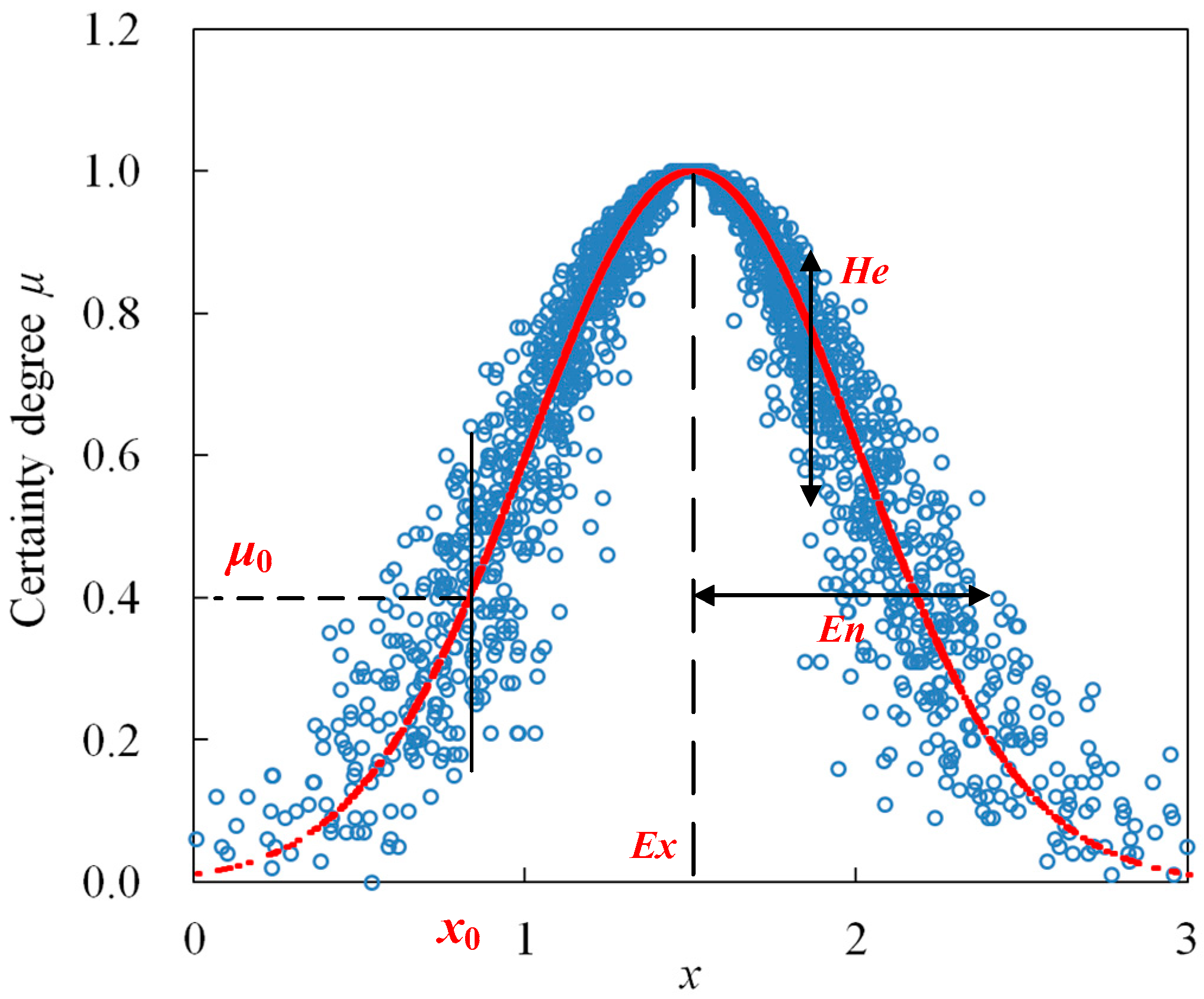
2.1. Precondition Cloud Generator Algorithm

The Cloud model, proposed by the Chinese scholar D. Y. Li, is an effective mathematical cognitive tool for describing the uncertain transforming mechanism between a qualitative concept and its quantitative expression [14]. The Cloud model combines a probability feature with fuzzy properties so as to further expound system uncertainty, and applies three numerical characteristics to depict the uncertain concept: expectation Ex, entropy En, and hyper-entropy He, and their definition can be expressed as follows [15,17,19]:
Let U be a universal set denoted by precise data, and C be the qualitative concept related to U, if the distribution of random variable x (xU) satisfies xN(Ex, En′) and En′∊N(En, He), then x can be considered as a sample of concept C, and its certainty degree μ belonging to concept C can be determined as follows:
μ = exp [ ( x E x ) 2 2 ( E n ) 2 ]
Besides this, the distribution of random variable x in the universe U is defined as a one-dimension normal cloud, and point [x, μ(x)] is defined as a cloud drop, which denotes a fuzzy realization of random variable x. Figure 1 shows the distribution of cloud drops belonging to concept C, in which, Ex = 1.5, En = 0.5, and He = 0.1.
As shown in Figure 1, expectation Ex is the most representative and typical sample of qualitative concept C. Entropy En is relevant to the uncertainty of concept C, which reflects both the random dispersing extent of cloud drops and the average accepted scope of concept C. Hyper-entropy He is the uncertainty degree of entropy En, which makes all cloud drops uniformly distribute on both sides of expectation curve of a normal cloud [14]. The value of Ex, En, and He can be obtained from the interval boundaries of concept C according to the “3En” principle; this principle reflects the dispersion degree and distribution range of a specific cloud concept, and indicates that most of the cloud drops that contribute to the specific qualitative cloud concept will mainly fall in [Ex − 3En, Ex + 3En]. For details, the readers can refer to [14,16].
The application of the Cloud model in drought risk assessment is actually the generation process of cloud drops based on the precondition cloud algorithm. For example, supposing X0 = [P0, R0] denotes a given drought sample (as shown in Figure 1), the membership degree of X0 belonging to specific drought risk level C0 can be obtained by the certainty degree μ of multiple drought drops [14,17]. Figure 2 illustrates the calculation procedure of the certainty degree for cloud drops when employing the anomaly percentage of precipitation P and streamflow R to describe the drought risk properties.
As shown in Figure 2, let C0 = [CGP(ExP, EnP, HeP), CGR(ExR, EnR, HeR)] denote a specific drought risk level cloud expressed by the anomaly percentage of precipitation P and streamflow R, and then the two-dimensional precondition cloud algorithm can be achieved as the following steps:
Step 1:
generate two normally distributed random numbers EnP′ and EnR′ satisfying EnP′∊N(EnP, HeP) and EnR′∊N(EnR, HeR), respectively.
Step 2:
calculate the certainty degree μ0 of the given drought sample X0 = [P0, R0] belonging to specific drought risk level cloud C0 as follows
μ 0 = exp { [ ( P 0 E x p ) 2 2 ( E n p ) 2 + ( R 0 E x R ) 2 2 ( E n R ) 2 ] }
Step 3:
repeat Step 1 and Step 2 until generating Nc cloud drops, and then the final certainty degree can be obtained by the average of Nc cloud drops.

2.2. Principle of Maximum Entropy

Uncertainty is one of the fundamental properties of the hydrologic process. As an important measuring index of uncertainty for a stochastic variable, the concept of entropy was first formulated by Shannon [21,22], and so far has been extensively and effectively applied in the hydrologic uncertainty analysis field [22].
The Shannon entropy H(x) of probability density function f(x) for a continuous variable X = {x1, x2, …, xn} can be defined as
H ( x ) = H n ( p 1 ,   p 2 ,   ,   p n ) = a b f ( x ) ln f ( x ) d x  
where a and b denote the lower and upper limits of X, respectively [11,22]. The entropy H(x) represents the uncertainty of X, i.e., the larger the entropy H(x) of variable X is, the greater its uncertainty becomes, and the more disorderly its distribution will be. Therefore, an important application of Shannon entropy is to estimate the probability distribution of X when its accurate distribution function cannot be attained based on the existing understanding, and this is exactly the essence of the principle of maximum entropy (POME) [23]. According to the POME, the probability distribution function of X with the maximum entropy in terms of given constraints is so far the most accurate and reasonable. Generally, the POME can be accomplished by solving the following optimization model.
max H = a b f ( x ) ln f ( x ) d x s . t . f ( x ) > 0    x [ a ,   b ] C 0 = a b f ( x ) d x = 1 C r = a b g r ( x ) f ( x ) d x = E r ( x )    ( r = 1 ,   2 ,   ,   n )
where constraint C0 states that the probability density function f(x) must satisfy the total probability theorem, Cr denotes the other given constraints gr(x) of X, n represents the number of constraints, and Er(x) denotes the expectation of constraints gr(x). The above optimization model can be solved through the Lagrange multiplier method [11,23]) and the Accelerating Genetic Algorithm (AGA), which is a simple and frequently applied intelligent algorithm for optimization modelling [24].
If applying the Lagrange multiplier method to calculate the optimal probability distribution f(x), the Lagrangian function L, which is subjected to the constraints expressed in Equation (4), can be written as [11]
L = a b f ( x ) ln f ( x ) d x ( λ 0 1 ) [ a b f ( x ) d x 1 ] r = 1 n λ 0 [ a b g r ( x ) f ( x ) d x E r ( x )   ]  
where λr denotes the Lagrange multipliers. f(x) can be attained through maximizing the function L, and therefore one differentiates L with respect to f(x) being equal to zero.
L f = 0 [ 1 + ln f ( x ) ] ( λ 0 1 ) r = 1 n λ r g r ( x ) = 0  
Hence, the resulting maximum-entropy-based probability distribution f(x) of X in terms of the given constraints can be written as
f ( x ) = exp [ λ 0 r = 1 n λ r g r ( x ) ]  
The probability distribution f(x) of X in Equation (7) is expressed by the Lagrange multipliers λr. After the determination of the Lagrange multipliers λr by inserting Equation (7) into the original constraints in Equation (4), then we can obtain [23]
f ( x ) = 1 r = 1 n E r ( x ) exp ( x r = 1 n E r ( x ) )  
So, it is obvious that variable X follows a negative exponential distribution pattern when satisfying the POME, and this estimation method is only applicable when the expectation Er(x) of the constraints is finite.

2.3. Construction of the Precondition Cloud and Maximum Entropy Principle (PCMEP) Coupling Model for Drought Risk Assessment

The drought risk is usually described by multiple drought indicators, and the Copula-based approach is widely used to combine multiple drought indicators to reveal the randomness of a drought risk system [25,26,27]. Comparatively, the PCMEP model mainly focuses on the exploration of the fuzziness of a drought risk system by the generation of cloud drops. Therefore, if the observed drought sample is not enough to fit the distribution function of the drought indicators, the PCMEP model can be applied to determine the drought risk from a fuzzy analysis perspective. Generally, the cloud drops for a specific drought sample generated by the precondition cloud algorithm are all assumed to be uniformly distributed, while this conclusion cannot be proved based on the existing understanding of the Cloud model. Therefore, the POME can be introduced to estimate the probability distribution of cloud drops belonging to different drought risk levels. Then, the PCMEP coupling model for drought risk assessment can be established according to the following steps:
Step 1:
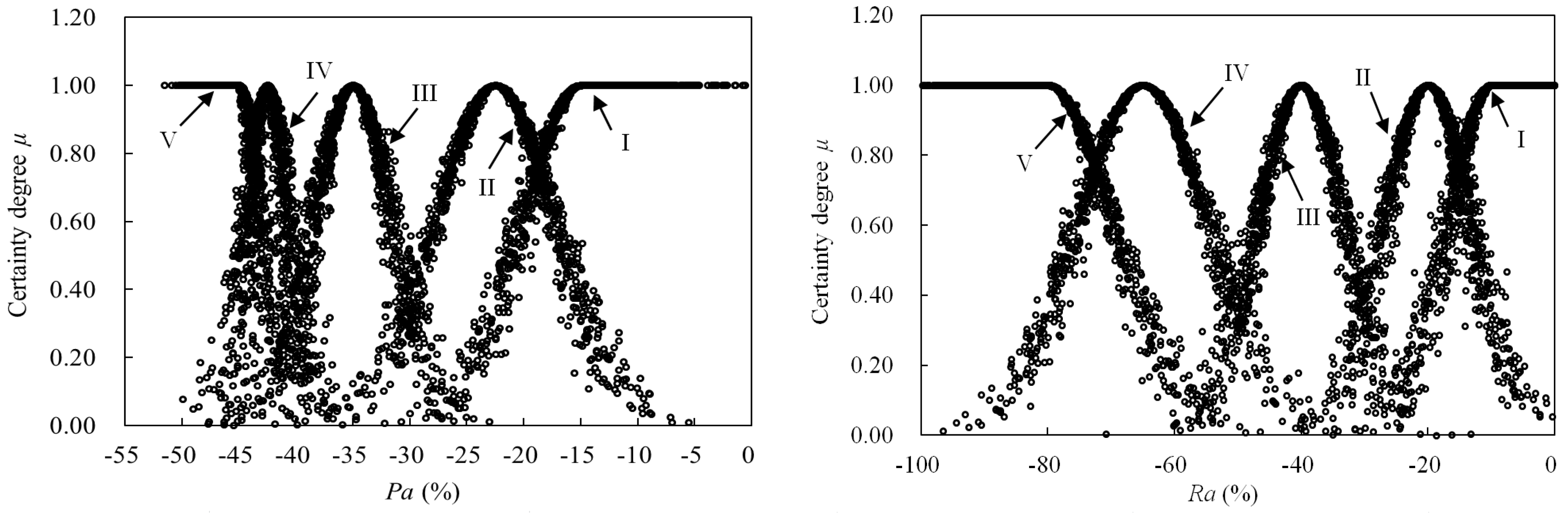
Construction of assessment sample, indices, and standard data set for drought risk. Considering the availability and representativeness of the drought index data series, the anomaly percentage of precipitation P and streamflow R are employed to indicate the drought risk, then the cloud characteristics for each drought risk level can be obtained from the traditional interval standard, and finally the drought risk assessment sample set can be established and denoted as X = {(Pi, Ri)|i = 1 − M}, where M represents the number of drought samples.
Step 2:
Calculation of the certainty degree belonging to each drought risk level by the precondition cloud algorithm. If hypothesizing that uijk denotes the certainty degree of the ith drought sample and the jth cloud drop belonging to the kth drought risk level, then the final certainty degree matrix can be denoted as U = {uijk|i = 1 − M, j = 1 − N, k = 1 − K}, where N and K represent the number of cloud drops and drought risk levels, respectively.
Step 3:
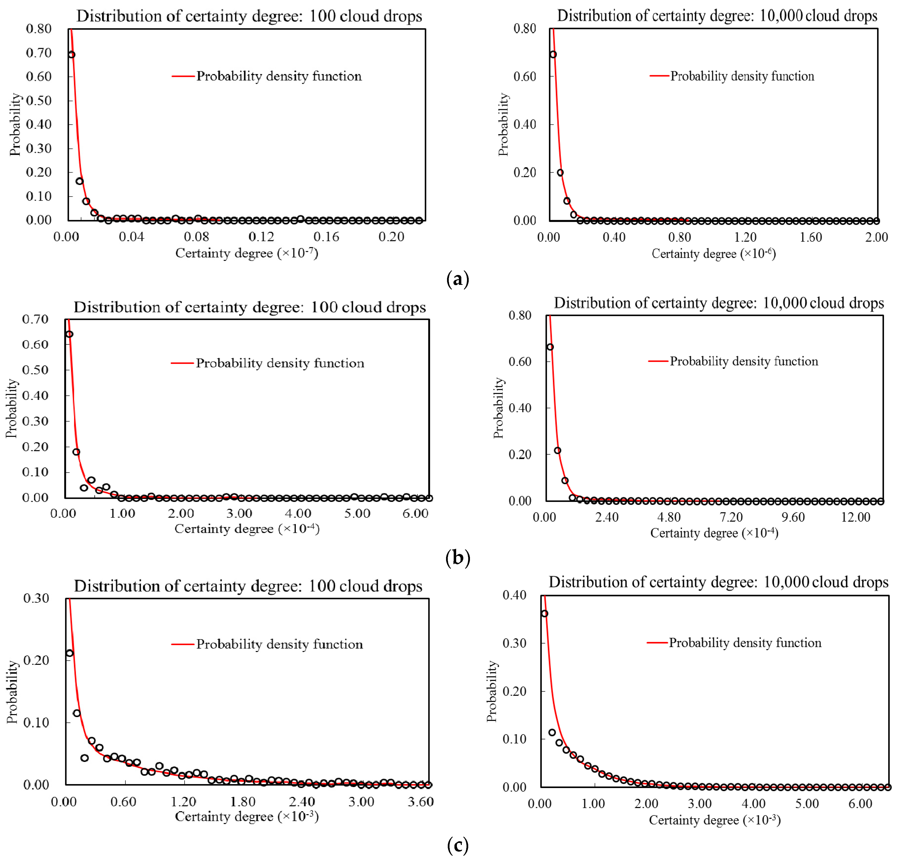
Computation of the certainty degree component matrix V = {vik|i = 1 − M, k = 1 − K}. Supposing vik denotes the certainty degree component of the ith drought sample belonging to the kth drought risk level, then vik can be obtained based on the probability distribution of Nc cloud drops that follows a negative exponential distribution rather than a uniform distribution, as follows
v i k = j = 1 N p i j u i j k
where pij is determined by Equation (8) and represents the probability of the ith drought sample and the jth cloud drop.
Step 4:
Determination of the drought risk level for the drought sample set. If denoting di as the characteristic value of drought risk level for the ith drought sample, then it becomes
d i = k = 1 K k v i k
So, the trend of drought risk level characteristic di can be utilized to analyze the varying of drought risk conditions and its relationship with the drought indicators.

3. Case Study

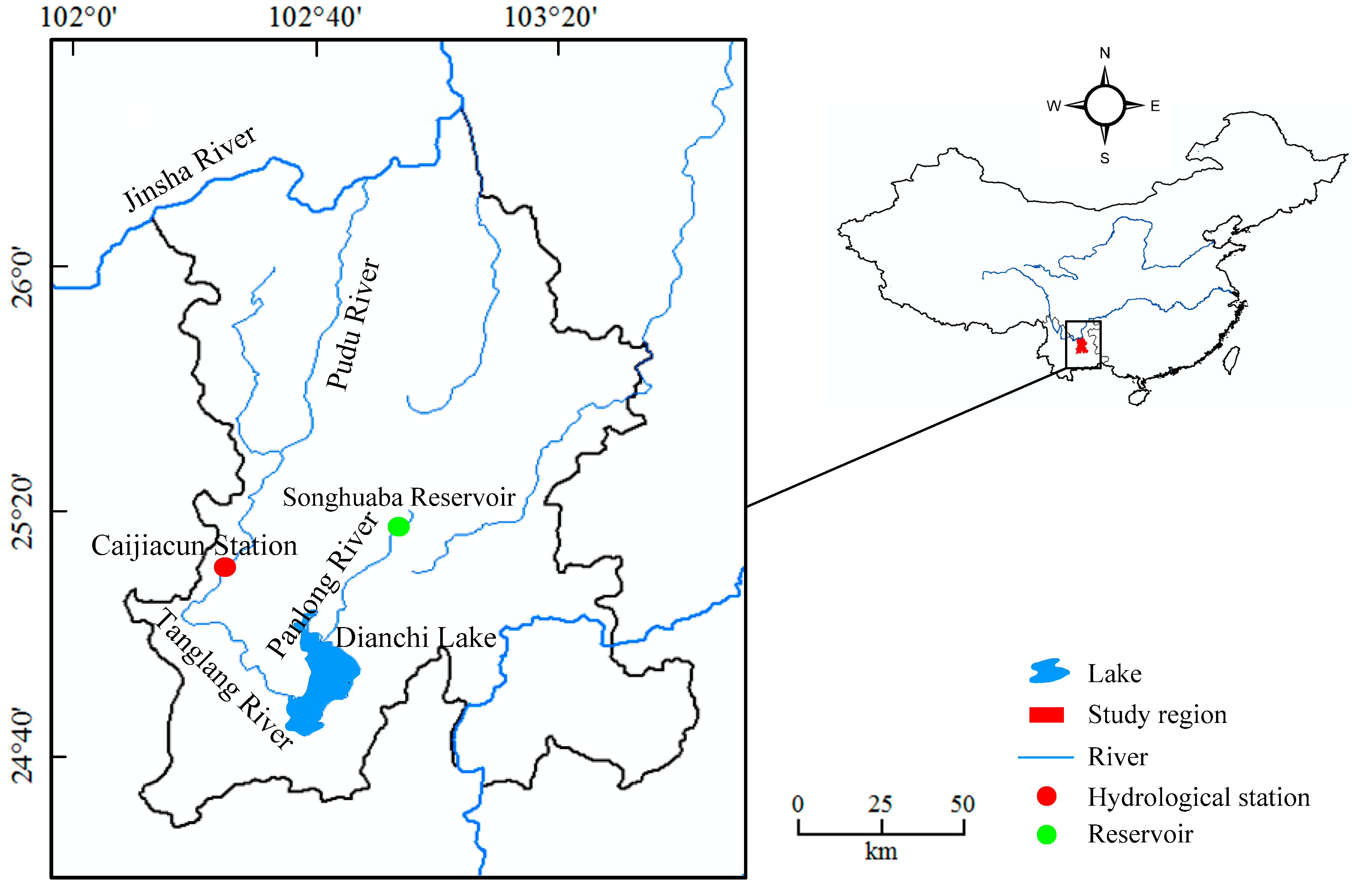
3.1. Data and Study Area

Kunming city, the capital city of Yunnan Province, is located in the southwest of China, which has a distinct difference between the dry season and the wet season, and the precipitation within the wet season accounts for 88% of the total. Recently, the occurrence of drought disasters has been frequent in Kunming city, and the frequency and extent of drought disasters have become more and more severe. Especially, in 2010, the Yunnan Province experienced an extremely serious drought disaster loss with the return period of 100 years [28]. Figure 3 shows the location of Kunming city and its surrounding water system distribution.
As shown in Figure 3, as the upper reaches of the Yangtse River, the Jinsha River flows along the northern boundary of Kunming city, and the Pudu River is one of the major tributaries of the Jinsha River, which consists of the Panlong River in the upper, the Tanglang River in the middle, and the Pudu River in the lower Jinsha River. The Caijiacun hydrological station, located in the middle of Pudu River, E 102°26′ and N 25°10′, is an important national hydrological station in the lower Jinsha river, which undertakes the observation task of flow from Dianchi Lake (the biggest plateau lake in the upper Yangtse River) and Songhuaba Reservoir (the primary water-supply source of Kunming city). Therefore, considering the availability of the drought level division standard released by the China Meteorological Administration in 2006, the anomaly percentage of precipitation and streamflow were selected as the drought indicators in this study, and the annual average precipitation of Kunming city and observed streamflow data of Caijiacun station covering 1956 to 2011 were collected to describe the drought risk features of Kunming city. Additionally, the relationship between the trend of drought indicators and the drought risk assessment result is discussed in this study. Figure 4 illustrates the evolutional trend of precipitation and streamflow covering 1956 to 2011, which has a good consistency with each other, and the Kendall correlation coefficient τ is 0.5468.

3.2. Drought Risk Assessment of Kunming City, 1956–2011, by PCMEP

Table 1 shows the hydrologic drought classification benchmark indicated by the anomaly percentage of precipitation and streamflow, where the drought risk is categorized into five levels, i.e., level I (normal), level II (light drought), level III (moderate drought), level IV (severe drought), and level V (extreme drought) [29]. Correspondingly, three cloud characteristics Ex, En, and He for each drought risk level can be obtained from its interval threshold based on the “3 En” principle of normal cloud distribution, which is listed in Table 2.
In this study, the standard interval of drought level I and V for each drought indicator is not inclusive; therefore, it is hypothesized that the cloud distribution patterns of drought risk level I and V are all semi-cloud distribution patterns. Additionally, the entropy value En of level I and V is considered to be equal to that of its neighboring level II and IV. Therefore, the entire cloud distribution pattern of each drought risk level indicated by the anomaly percentage of precipitation and streamflow can be demonstrated as shown in Figure 5.
Based on the drought risk classification standard expressed by the cloud characteristics, the drought risk level of Kunming city, 1956–2011, can be evaluated by applying the proposed PCMEP model. In order to further verify the rationality of PCMEP, the AGA, the traditional precondition cloud model (PCM, i.e., supposing Nc cloud drops are uniformly distributed), and the traditional Cloud model (CM, i.e., supposing the weight of each index is equal) were also applied to calculate the drought risk level of Kunming city, 1956–2011, and the results are listed in Table 3.

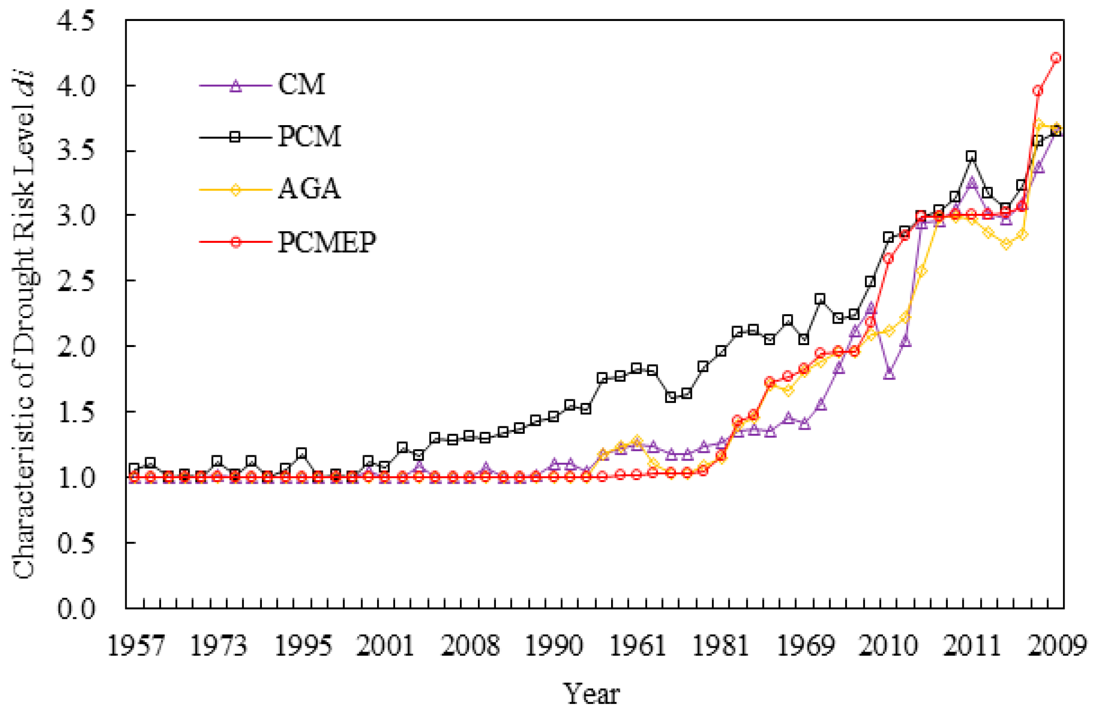
3.3. Result Analysis of Drought Risk Assessment in Kunming City, 1956–2011

As indicated in Table 3, according to the calculation result by the PCMEP method, amongst the 56 historical years of Kunming city, there are 38 years with drought level I, 7 years with drought level II, 9 years with drought level III, and 2 years with drought level IV. The varying trend of drought risk determined by PCMEP is generally consistent with that of CM, PCM, and AGA as illustrated in Figure 6. Furthermore, the variance of the drought risk assessment result of Kunming city, 1956–2011, determined by PCMEP, AGA, PCM, and CM is 0.7758, 0.6307, 0.5197, and 0.6119, respectively. Thus, it can be concluded that the difference of drought risk characteristics calculated by PCMEP is more evident than that of AGA, PCM, and CM, so the PCMEP model is expected to be more beneficial to recognize an accurate drought risk level of each drought sample.
Additionally, owing to the drought risk being represented by the indicators of the anomaly percentage of precipitation and streamflow, the calculation result of drought risk level over the historical years should be consistent with the varying trend of drought indices. To verify this, the correlation between drought risk characteristics and drought indices was calculated statistically as shown in Table 4.
As shown in Table 4, the correlation coefficient between the drought risk characteristics of Kunming city, 1956–2011, calculated by PCMEP and the drought indices series is −0.8121 and −0.8003, respectively, which are higher than that of the AGA, PCM, and CM methods. Therefore, it can be deduced that the PCMEP model can better reveal the drought risk properties described by precipitation and streamflow and estimate the distribution of cloud drops, and the final calculation result is more reasonable and reliable than that of the AGA, PCM, and CM methods.

3.4. Result Analysis of Drought Risk Assessment in Kunming City, 2009

As shown in Table 3, the characteristic value of drought risk of Kunming city in 2009 is the highest (level IV) among the 56 historical years. Hence, the calculation result in 2009 is specifically selected to further elaborate the rationality of the PCMEP model in this study. So, if hypothesizing that the number of cloud drops is 100 and 10,000, then the probability distribution of cloud drops corresponding to different drought risk levels when applying the PCMEP model to calculate the drought risk level in 2009 can be illustrated as in Figure 7.
In can be seen that: (1) as shown in Table 3, the certainty degree component for different drought risk levels in 2009 as determined by PCMEP is 0.0000, 0.0000, 0.0267, 0.7417, and 0.2316, respectively, and the certainty degree component for level IV is the highest. This is consistent with the certainty degree distribution of level IV as shown in Figure 7; (2) as a result of the POME constraint, the cloud drops for each drought risk level determined by PCMEP are negatively and exponentially distributed. Additionally, it can be evidently testified that the greater the number of cloud drops is, the smoother its distribution curve becomes, especially for levels IV, III, and V.
Moreover, the certainty degree of the cloud drops itself determined by PCMEP, AGA, and PCM is essentially the same; the primary difference among the three models is that a different distribution probability of cloud drops is applied to integrate the final certainty degree. Specifically, the certainty degree component and distribution differences of cloud drops for each level determined by PCMEP, AGA, and PCM are exhibited in comparison with CM as shown in Table 5 and Figure 8.
It can be indicated from Table 5 and Figure 8 that (1) the distribution interval of cloud drops determined by PCMEP, AGA, and PCM is comparatively more wider than that of the CM model, but the average for levels IV and III are 0.6254 and 0.4077, respectively, which are higher than that of the CM model. Besides this, the average of the certainty degree for level V determined by PCMEP, AGA, and PCM is much lower than that of the CM model. Therefore, the distribution pattern of cloud drops determined by PCMEP, AGA, and PCM can further magnify the difference in the certainty degree of different levels, which is more advantageous to recognize an accurate drought risk level; (2) as for the PCMEP, AGA, and PCM models, the certainty degree component especially for levels IV and III calculated by PCMEP is higher than that of the other models. So, it is revealed that the hypothesis of cloud drops following a negative and exponential distribution for PCMEP is more beneficial to integrate and identify the final drought risk level.

4. Conclusions

Drought risk assessment is fundamental to natural disaster risk management. In this paper, the cloud model and entropy theory were utilized to quantify the uncertainty of a drought risk system, and then a precondition cloud and maximum entropy principle coupling model-based approach (PCMEP) was proposed to evaluate the comprehensive drought risk level. The primary novelty of the study is to recognize the drought risk level more reliably and objectively by employing the drought indices described by cloud characteristics to quantify drought risk, and utilizing the principle of maximum entropy to optimize the generation of cloud drops. Additionally, based on the application of PCMEP in the drought risk assessment of Kunming city from 1956 to 2011, the major conclusions are shown as follows:
(1)
The drought risk assessment result determined by PCMEP indicates that there are 38 years with level I, 7 years with level II, 9 years with level III, and 2 years with level IV, and the drought risk level in 2009 is the highest from 1956 to 2011 in Kunming city.
(2)
Meanwhile, the varying trend of the drought risk calculation result by PCMEP for historical years agrees well with that of the observed precipitation and streamflow data series, which indicates that the PCMEP coupling approach can better capture the characteristics of different drought indices, and the assessment result is more sensitive and reliable.
(3)
Furthermore, as a result of the consideration of the probability distribution for cloud drops subjected to the principle of maximum entropy, the drought risk assessment result of PCMEP is more beneficial and advantageous for decision-makers to recognize an accurate drought level. All in all, although the physical mechanism of the conversion from the internal division standard of the drought level into cloud characteristics is not clear, the PCMEP model is still an effective drought risk assessment approach to reveal the fuzziness of drought risk systems. It can be further extended and applied in combination with the randomness of a drought risk system so as to characterize the drought features from a more comprehensive and systematic perspective in the future work.

Author Contributions

In this paper, the establishment and computation of PCMEP model were accomplished by X.B. and Y.W., the framework and application results of PCMEP model were verified by J.J., and the English writing and grammar were revised by X.Q. and C.W.

Funding

This research was funded by National Key Research and Development Program of China with Grant No. 2016YFC0400900, 2016YFC0401305 and 2016YFC0401303, the National Natural Science Foundation of China with Grant No. 51479045 and 51579059), and the University Natural Science Research Project of Anhui Province with Grant No. 113052015KJ04.

Conflicts of Interest

The authors declare no conflicts of interest.

References

  1. Yuan, W.P.; Zhou, G.S. Theoratical study and research prospect on drought indices. Adv. Earth Sci. 2004, 19, 982–991. [Google Scholar]
  2. Mishra, K.; Singh, V.P. A review of drought concepts. J. Hydrol. 2010, 391, 202–216. [Google Scholar] [CrossRef]
  3. Wilhite, A.; Hayes, M.J.; Knutson, C.; Smith, K.H. Planning for drought: Moving from crisis to risk management. J. Am. Water Resourc. Assoc. 2000, 36, 697–710. [Google Scholar] [CrossRef]
  4. Mckee, T.B.; Doesken, N.J.; Kleist, J. The relationship of drought frequency and duration to time scales. In Proceedings of the 8th Conference on Applied Climatology, Anaheim, CA, USA, 17–22 January 1993; Volume 17, pp. 179–183. [Google Scholar]
  5. Sun, P.; Zhang, Q.; Bai, Y.G.; Zhang, J.H. Variable fuzzy algorithm-based risk evaluation of droughts over the Tarim River Basin. J. Nat. Disasters 2014, 23, 148–155. (In Chinese) [Google Scholar]
  6. Zhou, Y.L.; Lai, C.G.; Wang, Z.L.; Chen, X.H.; Zeng, Z.Y.; Chen, J.C.; Bai, X.Y. Quantitative Evaluation of the Impact of Climate Change and Human Activity on Runoff Change in the Dongjiang River Basin, China. Water 2018, 10, 571. [Google Scholar] [CrossRef]
  7. Zhou, Y.L.; Liu, L.; Zhou, P.; Jin, J.L.; Li, J.Q.; Wu, C.G. Identification of drought and frequency analysis of drought characteristics based on palmer drought severity index model. Trans. Chin. Soc. Agric. Eng. 2014, 30, 175–184. [Google Scholar]
  8. Palmer, W.C. Meteorologic Drought; Research Paper No. 45; US Department of Commerce, Weather Bureau: Silver Spring, MD, USA, 1965.
  9. Wang, Z.L.; Li, J.; Lai, C.G.; Zeng, Z.Y.; Zhong, R.D.; Chen, X.H.; Zhou, X.W.; Wang, M.Y. Does drought in China show a significant decreasing trend from 1961 to 2009. Sci. Total Environ. 2017, 579, 314–324. [Google Scholar] [CrossRef] [PubMed]
  10. Wang, Z.L.; Zhong, R.D.; Lai, C.G.; Zeng, Z.Y.; Lian, Y.Q.; Bai, X.Y. Climate change enhances the severity and variability of drought in the Pearl River Basin in South China in the 21st century. Agric. For. Meteorol. 2018, 249, 149–162. [Google Scholar] [CrossRef]
  11. Guo, A.J.; Chang, J.X.; Wang, Y.M.; Huang, Q.; Guo, Z.H. Maximum Entropy-Copula Method for Hydrological Risk Analysis under Uncertainty: A Case Study on the Loess Plateau, China. Entropy 2016, 19, 609. [Google Scholar] [CrossRef]
  12. Fan, Y.R.; Huang, W.W.; Huang, G.H.; Huang, K.; Li, Y.P.; Kong, X.M. Bivariate hydrologic risk analysis based on a coupled entropy-copula method for the Xiangxi River in the Three Gorges Reservoir area, China. Theor. Appl. Climatol. 2016, 125, 381–397. [Google Scholar] [CrossRef]
  13. Liu, D.F.; Wang, D.; Wu, J.C.; Wang, Y.K.; Wang, L.C.; Zou, X.Q.; Chen, Y.F.; Chen, X. A risk assessment method based on RBF artificial neural network-cloud model for urban water hazard. J. Intell. Fuzzy Syst. 2014, 27, 2409–2416. [Google Scholar]
  14. Li, D.Y.; Du, Y. Artificial Intelligence with Uncertainty; National Defence Industry Press: Beijing, China, 2005. (In Chinese) [Google Scholar]
  15. Chen, J.F.; Zhao, S.F.; Shao, Q.X.; Wang, H.M. Risk Assessment on drought disaster in China based on integrative cloud model. Res. J. Appl. Sci. Eng. Technol. 2012, 4, 1137–1146. [Google Scholar]
  16. Zhang, Q.W.; Zhang, Y.Z.; Zhong, M. A cloud model based approach for multi-hierarchy fuzzy comprehensive evaluation of reservoir-induced seismic risk. J. Hydraul. Eng. 2014, 45, 87–95. (In Chinese) [Google Scholar]
  17. Wang, D.; Ding, H.; Singh, V.P.; Shang, X.S.; Liu, D.F.; Wang, Y.K.; Zeng, X.K.; Wu, J.C.; Wang, L.C.; Zou, X.Q. A hybrid wavelet analysis-cloud model data-extending approach formeteorologic and hydrologic time series. J. Geophys. Res. Atmos. 2015, 120, 1038–1047. [Google Scholar]
  18. Wang, D.; Liu, D.F.; Ding, H.; Singh, V.P.; Wang, Y.K.; Zeng, X.K.; Wu, J.C.; Wang, L.C. A cloud model-based approach for water quality assessment. Environ. Res. 2016, 148, 24–35. [Google Scholar] [CrossRef] [PubMed]
  19. Wang, D.; Zeng, D.B.; Singh, V.P.; Xu, P.C.; Liu, D.F.; Wang, Y.K.; Zeng, X.K.; Wu, J.C.; Wang, L.C. A multidimension cloud model-based approach for water quality assessment. Environ. Res. 2016, 149, 113–121. [Google Scholar] [CrossRef] [PubMed]
  20. Fu, Q.; Meng, F.X.; Li, T.X.; Liu, D.; Gong, F.L.; Amgad, O.; Li, Y.T. Cloud model-based analysis of regional sustainable water resource utilization schemes. Int. J. Agric. Biol. Eng. 2016, 9, 67–75. [Google Scholar]
  21. Shannon, C.E. A mathematical theory of communications. Bell Syst. Tech. J. 1948, 27, 379–423. [Google Scholar] [CrossRef]
  22. Karmeshu, J. Entropy Measures, Maximum Entropy Principle and Emerging Applications; Springer: New York, NY, USA, 2003. [Google Scholar]
  23. Feng, S.Y. Information entropy and the principle of maximun entropy. Water Conserv. Hydropower Technol. 1995, 22, 24–29. [Google Scholar]
  24. Jin, J.L.; Ding, J. Water Resources Systems Engineering; Sichuan Science and Technology Publishing House: Chengdu, China, 2002. (In Chinese) [Google Scholar]
  25. Yang, J.; Chang, J.X.; Wang, Y.M.; Li, Y.Y.; Hu, H.; Chen, Y.T.; Huang, Q.; Yao, J. Comprehensive drought characteristics analysis based on a nonlinear multivariate drought index. J. Hydrol. 2018, 557, 651–667. [Google Scholar] [CrossRef]
  26. Huang, S.Z.; Hou, B.B.; Chang, J.X.; Huang, Q.; Chen, Y.T. Spatial-temporal change in precipitation patterns based on the cloud model across the Wei River Basin, China. Theor. Appl. Climatol. 2015, 120, 391–401. [Google Scholar] [CrossRef]
  27. Fischer, T.; Gemmer, M.; Su, B.; Scholten, T. Hydrological long-term dry and wet periods in the Xijiang River basin, South China. Hydrol. Earth Syst. Sci. 2013, 17, 135–148. [Google Scholar] [CrossRef] [Green Version]
  28. Zhou, Y.L.; Zhou, P.; Jin, J.L.; Li, J. Establishment of hydrological drought index based on sources of regional water supply and its application to drought frequency analysis for Kunming. J. Hydraul. Eng. 2014, 45, 1075–1083. (In Chinese) [Google Scholar]
  29. China Meteorological Administration. Classification of Meteorological Drought, GB/T20481-2006; China Meteorological Administration: Beijing, China, 2006. (In Chinese)
Figure 1. Cloud map of qualitative concept C (1.5, 0.5, 0.1).
Sustainability 10 03236 g001
Figure 2. Procedure of two-dimensional precondition cloud generator algorithm.
Sustainability 10 03236 g002
Figure 3. Location of the Caijiacun hydrologic station and Kunming city.
Sustainability 10 03236 g003
Figure 4. Trend of precipitation and streamflow in Kunming city, 1956–2011.
Sustainability 10 03236 g004
Figure 5. Cloud distribution patterns for the anomaly percentage of precipitation and streamflow.
Sustainability 10 03236 g005
Figure 6. Trend of drought risk assessment result in Kunming city, 1956–2011.
Sustainability 10 03236 g006
Figure 7. Probability distribution of cloud drops for different drought risk levels in 2009. (a) Drought risk level: I; (b) drought risk level: II; (c) drought risk level: III; (d) drought risk level: IV; (e) drought risk level: V.
Sustainability 10 03236 g007aSustainability 10 03236 g007b
Figure 8. Distribution of the certainty degree for cloud drops determined by PCMEP, AGA, PCM, and CM. (a) PCMEP, AGA, and PCM. (b) CM.
Sustainability 10 03236 g008
Table 1. Division standard of drought level (%).
Drought IndexIIIIIIIVV
Anomaly Percentage of Precipitation (Pa)−15 < Pa−30 < Pa ≤ −15−40 < Pa ≤ −30−45 < Pa ≤ −40Pa ≤ −45
Anomaly Percentage of Streamflow (Ra)−10 < Ra−30 < Ra ≤ −10−50 < Ra ≤ −30−80 < Ra ≤ −50Ra ≤ −80
Table 2. Cloud characteristic value of drought level based on the anomaly percentage of precipitation and streamflow.
LevelsPaRa
ExEnHeExEnHe
I−15.005.200.01−10.006.930.01
II−22.505.200.01−20.006.930.01
III−35.003.470.01−40.006.930.01
IV−42.501.730.01−65.0010.400.01
V−45.001.730.01−80.0010.400.01
Table 3. Drought risk assessment result of Kunming city, 1956–2011.
YearCertainty Degree ComponentDrought Risk Level Characteristics diDrought Risk Levels
IIIIIIIVVPCMEPAGAPCMCMPCMEPAGAPCMCM
19560.99930.00070.00000.00000.00001.00071.00091.55121.1002IIIII
19571.00000.00000.00000.00000.00001.00001.00001.06571.0000IIII
19580.96680.03320.00000.00000.00001.03321.03511.60861.1812IIIII
19590.53170.46830.00000.00000.00001.46831.45342.12131.3764IIIII
19600.00000.00010.48820.61870.00313.95002.20113.56773.3698IVIIIVIII
19610.97610.02390.00000.00000.00001.02391.28971.83251.2584IIIII
19620.99920.00080.00000.00000.00001.00081.00091.52301.0410IIIII
19630.00020.15850.83810.00330.00002.84452.22532.87932.0469IIIIIIIIII
19640.97370.02630.00000.00000.00001.02631.10431.81981.2320IIIII
19651.00000.00000.00000.00000.00001.00001.00001.10201.0000IIII
19661.00000.00000.00000.00000.00001.00001.00001.00521.0000IIII
19670.27460.72530.00000.00000.00001.72541.71392.05081.3546IIIIIII
19681.00000.00000.00000.00000.00001.00001.00001.02441.0000IIII
19690.16790.83210.00010.00000.00001.83221.81962.04641.4142IIIIIII
19701.00000.00000.00000.00000.00001.00001.00001.22221.0000IIII
19711.00000.00000.00000.00000.00001.00001.00001.00941.0000IIII
19720.94700.05300.00000.00000.00001.05301.08391.83811.2430IIIII
19731.00000.00000.00000.00000.00001.00001.00001.12801.0120IIII
19741.00000.00000.00000.00000.00001.00001.00001.02401.0000IIII
19750.22740.77250.00010.00000.00001.77271.66482.19231.4541IIIIIII
19761.00000.00000.00000.00000.00001.00001.00001.17171.0896IIII
19770.00510.80830.18660.00000.00002.18152.09012.49422.2963IIIIIIII
19781.00000.00000.00000.00000.00001.00001.00001.28321.0006IIII
19791.00000.00000.00000.00000.00001.00001.00001.34401.0032IIII
19800.06060.93640.00310.00000.00001.94251.88192.35901.5577IIIIIIII
19810.83190.16810.00000.00000.00001.16811.15361.96141.2711IIIII
19820.00000.00320.99560.00120.00002.99802.58082.98862.9413IIIIIIIIIIII
19831.00000.00000.00000.00000.00001.00001.00001.12341.0057IIII
19840.04300.95630.00070.00000.00001.95761.95572.20801.8471IIIIIIII
19850.99170.00830.00000.00000.00001.00831.18521.75901.1729IIIII
19861.00000.00000.00000.00000.00001.00001.00001.00911.0000IIII
19870.00000.00020.99930.00050.00003.00032.98983.13733.0560IIIIIIIIIIII
19880.00000.00020.93730.05720.00533.06762.85403.22123.0913IIIIIIIIIIII
19890.00000.00110.97480.02330.00073.02362.78493.05022.9807IIIIIIIIIIII
19900.99960.00040.00000.00000.00001.00041.00031.45571.1071IIII
19911.00000.00000.00000.00000.00001.00001.00001.30101.0767IIII
19920.00000.00160.99830.00010.00002.99852.99783.03212.9583IIIIIIIIIIII
19930.00000.00060.99110.00770.00063.00832.87553.16273.0284IIIIIIIIIIII
19941.00000.00000.00000.00000.00001.00001.00001.06601.0000IIII
19951.00000.00000.00000.00000.00001.00001.00001.17291.0001IIII
19960.96200.03800.00000.00000.00001.03801.03741.63761.1760IIIII
19971.00000.00000.00000.00000.00001.00001.00001.00931.0000IIII
19981.00000.00000.00000.00000.00001.00001.00001.01511.0000IIII
19991.00000.00000.00000.00000.00001.00001.00001.00171.0000IIII
20001.00000.00000.00000.00000.00001.00001.00001.11851.0401IIII
20011.00000.00000.00000.00000.00001.00001.00001.07901.0000IIII
20021.00000.00000.00000.00000.00001.00001.00001.29171.0033IIII
20030.03630.96060.00310.00000.00001.96681.96022.24272.1218IIIIIIII
20040.98840.01160.00000.00000.00001.01161.23181.76561.2164IIIII
20051.00000.00000.00000.00000.00001.00001.00001.37271.0041IIII
20060.56430.43570.00000.00000.00001.43571.40732.10961.3524IIIII
20070.99990.00010.00000.00000.00001.00011.00011.43061.0130IIII
20081.00000.00000.00000.00000.00001.00001.00001.31461.0008IIII
20090.00000.00000.02670.74170.23164.20493.67003.64563.6555IVIVIVIV
20100.00210.33070.66730.00000.00002.66522.12272.82881.7955IIIIIIIIII
20110.00000.00000.99770.00230.00003.00232.97603.45683.2522IIIIIIIIIIII
PCMEP, precondition cloud and maximum entropy principle; AGA, Accelerating Genetic Algorithm; PCM, precondition cloud model; CM, cloud model.
Table 4. Correlation coefficient between drought level characteristics and drought indices.
Drought IndexPCMEPAGAPCMCM
Anomaly Percentage of Precipitation−0.8121−0.7512−0.7414−0.7572
Anomaly Percentage of Streamflow−0.8003−0.6877−0.6559−0.6516
Table 5. Statistics of the certainty degree component and Boxplot parameters.
Drought Risk LevelIIIIIIIVV
Certainty Degree ComponentPCMEP0.00000.00020.41820.66460.0070
AGA0.00000.00020.39000.61760.0070
PCM0.00000.00010.41500.59400.0062
CM0.00000.00370.40550.42690.1245
Boxplot ParametersPCMEP
AGA
PCM
Maximum0.00000.01200.99890.99970.4347
Upper quartiles0.00000.00010.62960.83890.0071
Median0.00000.00000.43420.56290.0035
Lower quartiles0.00000.00000.15150.36250.0009
Minimum0.00000.00000.00000.00000.0000
CMMaximum0.00120.02550.86840.53730.4364
Upper quartiles0.00000.00480.47330.46590.2536
Median0.00000.00280.41310.40090.1932
Lower quartiles0.00000.00170.37120.36950.0572
Minimum0.00000.00010.32360.02590.0001

