Comparing the Hydrological Responses of Conceptual and Process-Based Models with Varying Rain Gauge Density and Distribution


Abstract
1. Introduction
2. Materials and Methods
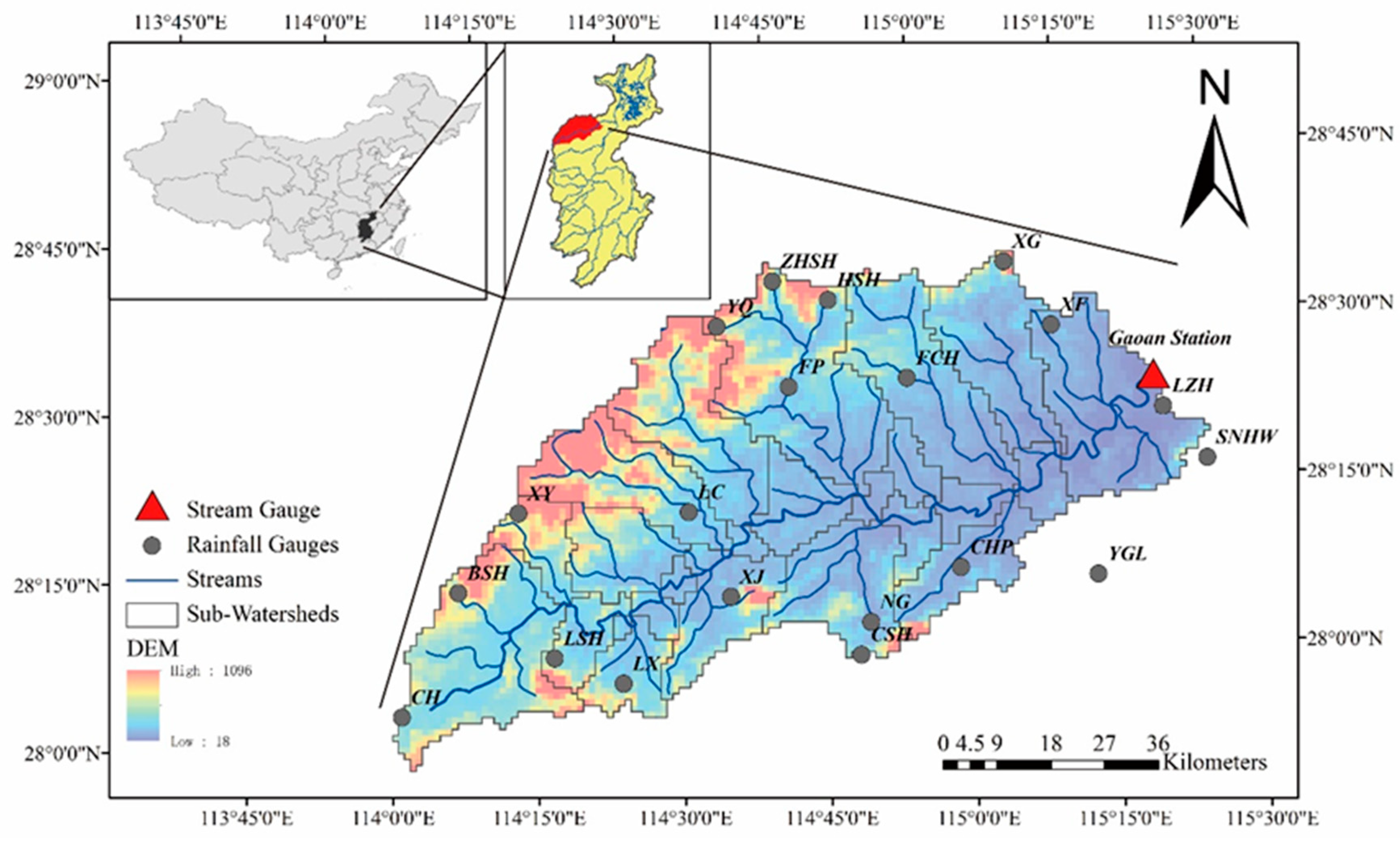
2.1. Study Area
2.2. Datasets
2.3. Models
2.3.1. Hydrologic Model (HYMOD)
2.3.2. Xinanjiang Model (XAJ)
2.3.3. Water and Energy Transfer Between Soil, Plants and Atmosphere Model (WetSpa)
2.3.4. Model Calibration and Validation
2.3.5. Scenario Settings
3. Results
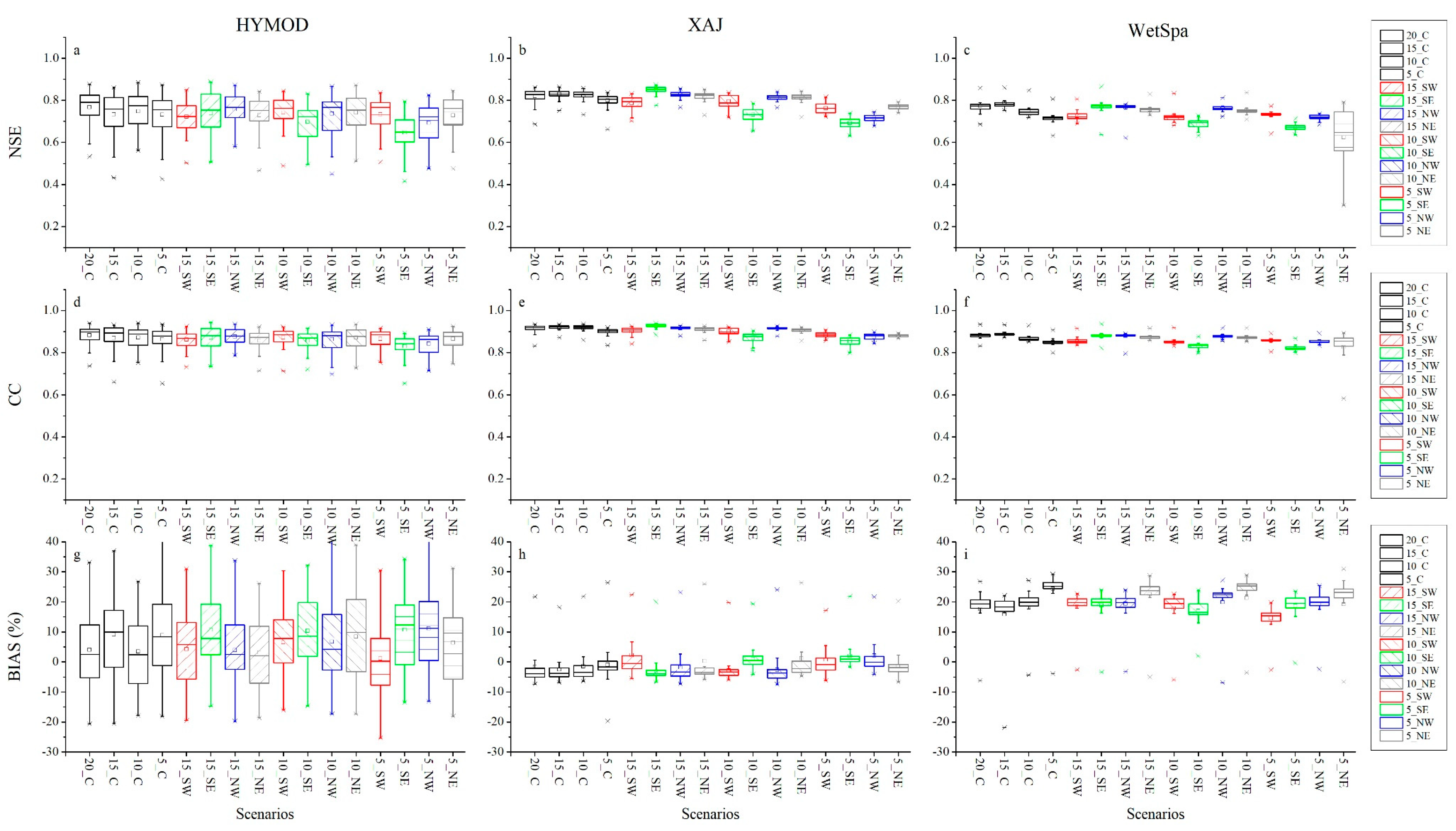
3.1. Model Performance in the Calibration and Validation Period
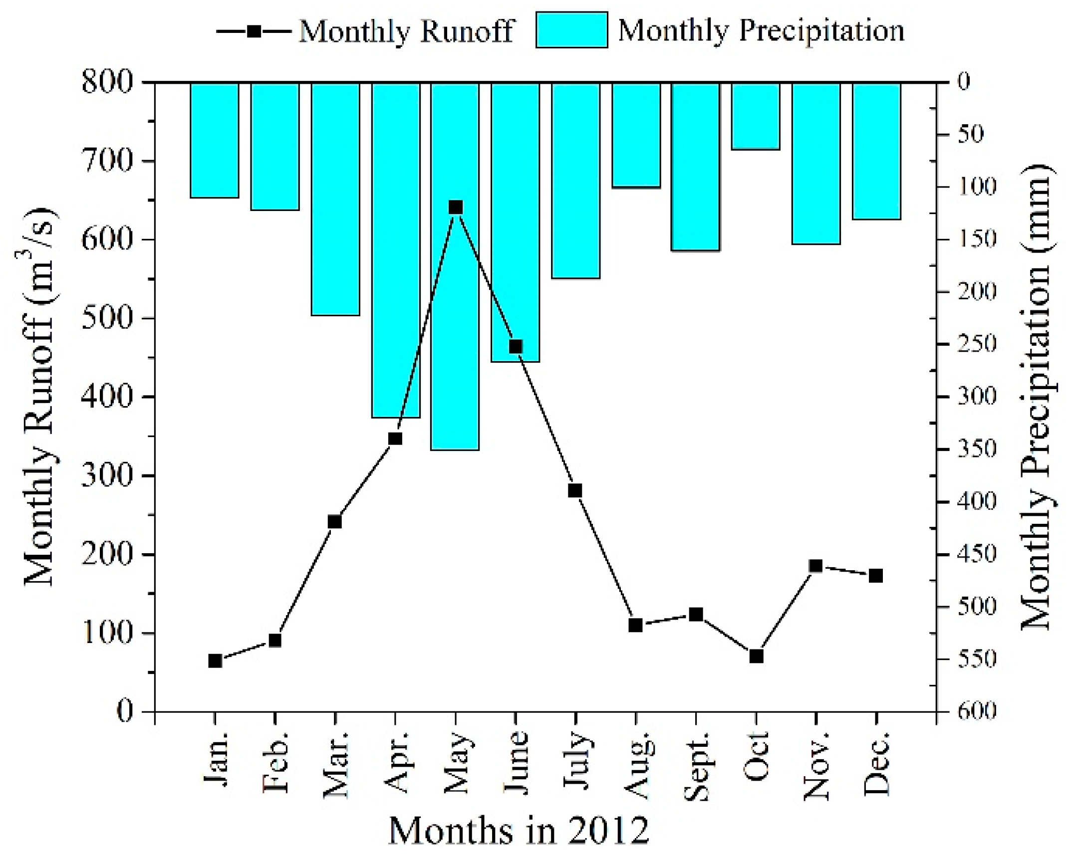
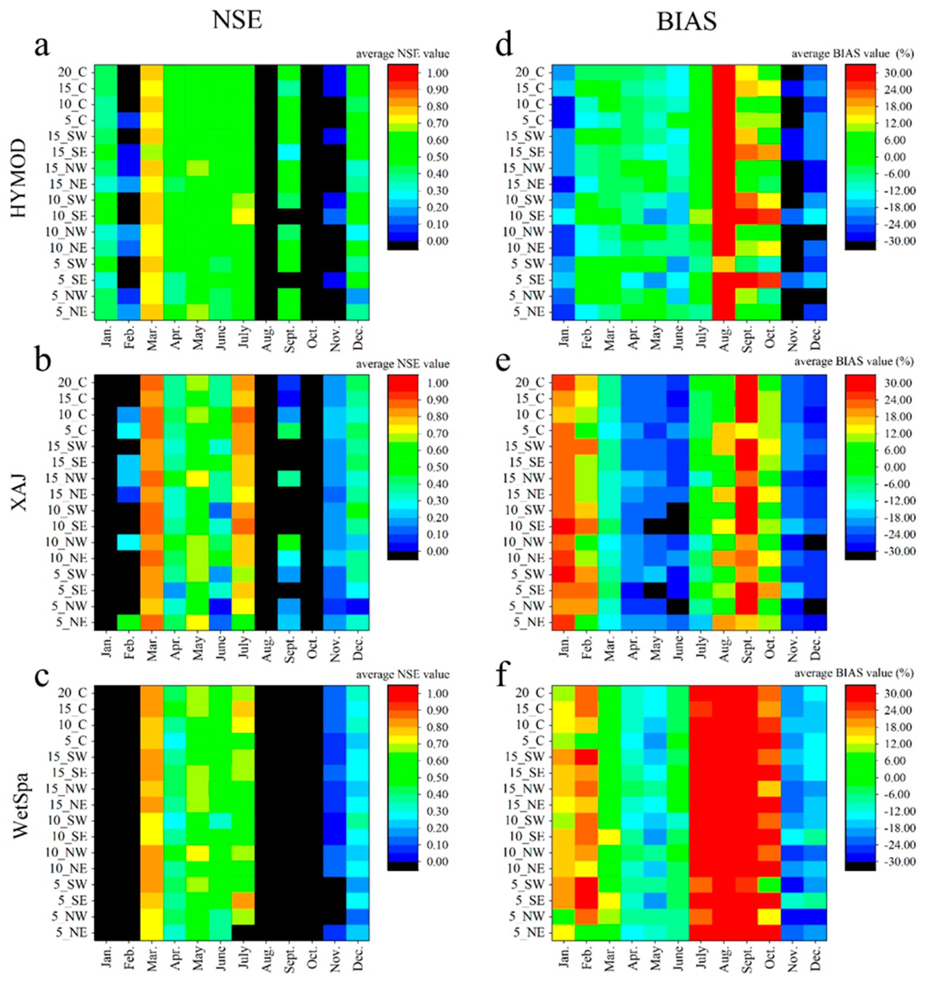
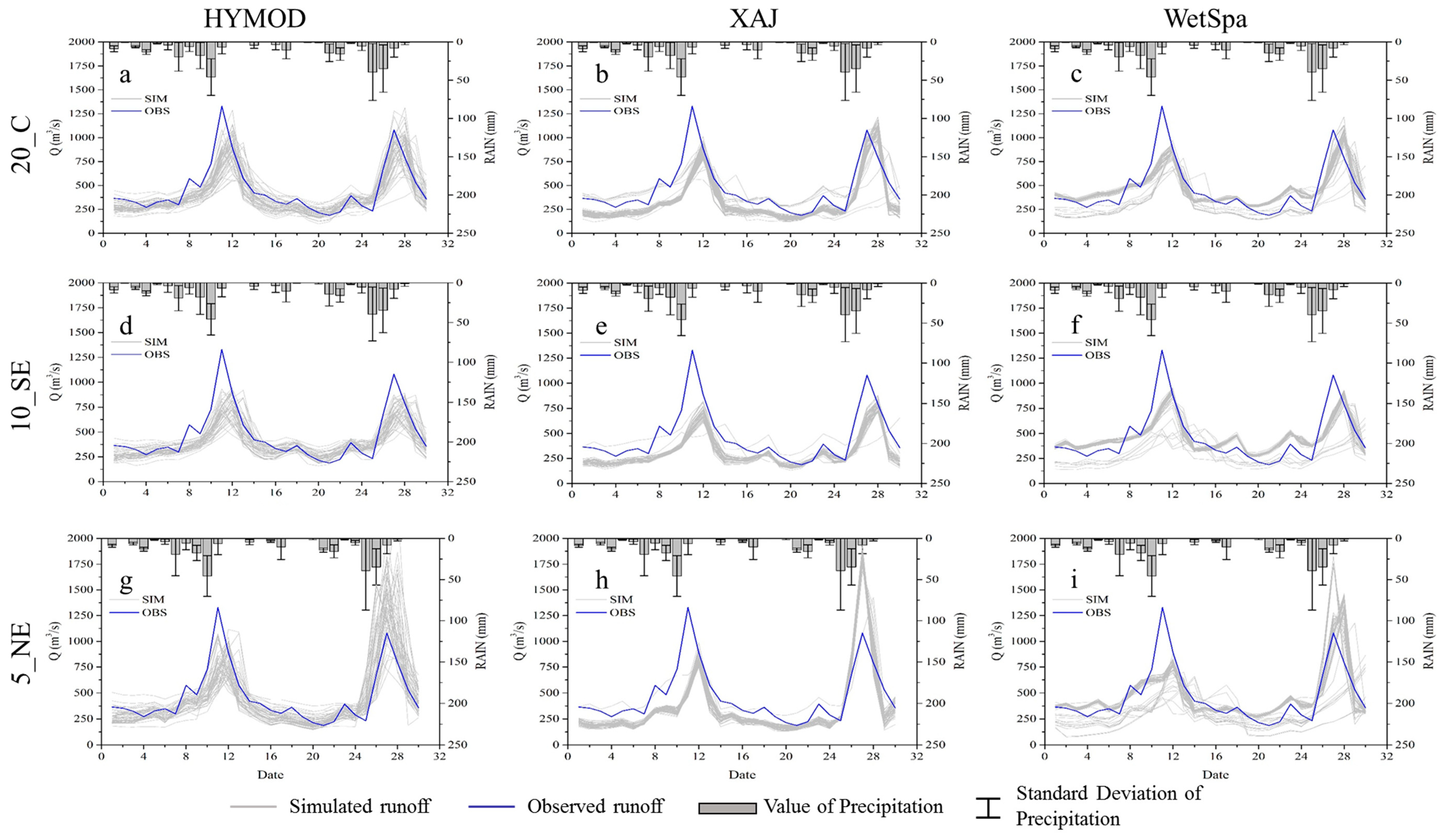
3.2. Monthly Analysis for 2012
3.3. Model Performance in June 2012
4. Discussion
4.1. Influence of Rain Gauge Distribution
4.2. Comparing Different Model Structures
4.3. Detailed Discussion on Model Performance
5. Conclusions
Author Contributions
Funding
Acknowledgments
Conflicts of Interest
References
- Syed, K.H.; Goodrich, D.C.; Myers, D.E.; Sorooshian, S. Spatial characteristics of thunderstorm rainfall fields and their relation to runoff. J. Hydrol. 2003, 271, 1–21. [Google Scholar] [CrossRef]
- Zehe, E.; Becker, R.; Bardossy, A.; Plate, E. Uncertainty of simulated catchment runoff response in the presence of threshold processes: Role of initial soil moisture and precipitation. J. Hydrol. 2005, 315, 183–202. [Google Scholar] [CrossRef]
- Bardossy, A.; Plate, E.J. Space-time model for daily rainfall using atmospheric circulation patterns. Water Resour. Res. 1992, 28, 1247–1259. [Google Scholar] [CrossRef]
- Krajewski, W.F.; Ciach, G.J.; Habib, E. An analysis of small-scale rainfall variability in different climatic regimes. Hydrol. Sci. J. 2003, 48, 151–162. [Google Scholar] [CrossRef]
- Ben Daoud, A.; Sauquet, E.; Bontron, G.; Obled, C.; Lang, M. Daily quantitative precipitation forecasts based on the analogue method: Improvements and application to a French large river basin. Atmos. Res. 2016, 169, 147–159. [Google Scholar] [CrossRef]
- Fu, G.; Charles, S.P.; Chiew, F.H.S.; Ekstrom, M.; Potter, N.J. Uncertainties of statistical downscaling from predictor selection: Equifinality and transferability. Atmos. Res. 2018, 203, 130–140. [Google Scholar] [CrossRef]
- Wen, X.; Liu, Z.; Lei, X.; Lin, R.; Fang, G.; Tan, Q.; Wang, C.; Tian, Y.; Quan, J. Future changes in Yuan River ecohydrology: Individual and cumulative impacts of climates change and cascade hydropower development on runoff and aquatic habitat quality. Sci. Total Environ. 2018, 633, 1403–1417. [Google Scholar] [CrossRef] [PubMed]
- Wilson, C.B.; Valdes, J.B.; Rodriguez-Iturbe, I. INFLUENCE OF THE SPATIAL-DISTRIBUTION OF RAINFALL ON STORM RUNOFF. Water Resour. Res. 1979, 15, 321–328. [Google Scholar] [CrossRef]
- Singh, V.P. Effect of spatial and temporal variability in rainfall and watershed characteristics on stream flow hydrograph. Hydrol. Process. 1997, 11, 1649–1669. [Google Scholar] [CrossRef]
- Sun, H.; Cornish, P.S.; Daniell, T.M. Spatial variability in hydrologic modeling using rainfall-runoff model and digital elevation model. J. Hydrol. Eng. 2002, 7, 404–412. [Google Scholar] [CrossRef]
- Shen, Z.; Chen, L.; Liao, Q.; Liu, R.; Hong, Q. Impact of spatial rainfall variability on hydrology and nonpoint source pollution modeling. J. Hydrol. 2012, 472–473, 205–215. [Google Scholar] [CrossRef]
- Emmanuel, I.; Payrastre, O.; Andrieu, H.; Zuber, F. A method for assessing the influence of rainfall spatial variability on hydrograph modeling. First case study in the Cevennes Region, southern France. J. Hydrol. 2017, 555, 314–322. [Google Scholar] [CrossRef]
- Li, D.; Christakos, G.; Ding, X.; Wu, J. Adequacy of TRMM satellite rainfall data in driving the SWAT modeling of Tiaoxi catchment (Taihu lake basin, China). J. Hydrol. 2018, 556, 1139–1152. [Google Scholar] [CrossRef]
- Sikorska, A.E.; Seibert, J. Value of different precipitation data for flood prediction in an alpine catchment: A Bayesian approach. J. Hydrol. 2018, 556, 961–971. [Google Scholar] [CrossRef]
- Lei, X.; Liao, W.; Wang, Y.; Jiang, Y.; Wang, H.; Tian, Y. Development and Application of a Distributed Hydrological Model: EasyDHM. J. Hydrol. Eng. 2014, 19, 44–59. [Google Scholar] [CrossRef]
- Huang, X.; Liao, W.; Lei, X.; Jia, Y.; Wang, Y.; Wang, X.; Jiang, Y.; Wang, H. Parameter optimization of distributed hydrological model with a modified dynamically dimensioned search algorithm. Environ. Model. Softw. 2014, 52, 98–110. [Google Scholar] [CrossRef]
- Anache, J.A.A.; Flanagan, D.C.; Srivastava, A.; Wendland, E.C. Land use and climate change impacts on runoff and soil erosion at the hillslope scale in the Brazilian Cerrado. Sci. Total Environ. 2018, 622, 140–151. [Google Scholar] [CrossRef] [PubMed]
- Brown, P.E.; Diggle, P.J.; Lord, M.E.; Young, P.C. Space-time calibration of radar rainfall data. J. R. Stat. Soc. Ser. C Appl. Stat. 2001, 50, 221–241. [Google Scholar] [CrossRef]
- Brussolo, E.; Von Hardenberg, J.; Ferraris, L.; Rebora, N.; Provenzale, A. Verification of Quantitative Precipitation Forecasts via Stochastic Downscaling. J. Hydrometeorol. 2008, 9, 1084–1094. [Google Scholar] [CrossRef]
- Xie, P.; Yatagai, A.; Chen, M.; Hayasaka, T.; Fukushima, Y.; Liu, C.; Yang, S. A Gauge-based analysis of daily precipitation over East Asia. J. Hydrometeorol. 2007, 8, 607–626. [Google Scholar] [CrossRef]
- Pardo-Iguzquiza, E. Optimal selection of number and location of rainfall gauges for areal rainfall estimation using geostatistics and simulated annealing. J. Hydrol. 1998, 210, 206–220. [Google Scholar] [CrossRef]
- Chen, D.; Ou, T.; Gong, L.; Xu, C.-Y.; Li, W.; Ho, C.-H.; Qian, W. Spatial Interpolation of Daily Precipitation in China: 1951–2005. Adv. Atmos. Sci. 2010, 27, 1221–1232. [Google Scholar] [CrossRef]
- Xu, H.; Xu, C.-Y.; Chen, H.; Zhang, Z.; Li, L. Assessing the influence of rain gauge density and distribution on hydrological model performance in a humid region of China. J. Hydrol. 2013, 505, 1–12. [Google Scholar] [CrossRef]
- Girons Lopez, M.; Wennerstrom, H.; Norden, L.-A.; Seibert, J. Location and density of rain gauges for the estimation of spatial varying precipitation. Geogr. Ann. Ser. A Phys. Geogr. 2015, 97, 167–179. [Google Scholar] [CrossRef]
- Michaud, J.D.; Sorooshian, S. Effect of rainfall-sampling errors on simulations of desert flash floods. Water Resour. Res. 1994, 30, 2765–2775. [Google Scholar] [CrossRef]
- Chaplot, V.; Saleh, A.; Jaynes, D.B. Effect of the accuracy of spatial rainfall information on the modeling of water, sediment, and NO3–N loads at the watershed level. J. Hydrol. 2005, 312, 223–234. [Google Scholar] [CrossRef]
- Andreassian, V.; Perrin, C.; Michel, C.; Usart-Sanchez, I.; Lavabre, J. Impact of imperfect rainfall knowledge on the efficiency and the parameters of watershed models. J. Hydrol. 2001, 250, 206–223. [Google Scholar] [CrossRef]
- Anctil, F.; Lauzon, N.; Andréassian, V.; Oudin, L.; Perrin, C. Improvement of rainfall-runoff forecasts through mean areal rainfall optimization. J. Hydrol. 2006, 328, 717–725. [Google Scholar] [CrossRef]
- Drogue, G.; Ben Khediri, W. Catchment model regionalization approach based on spatial proximity: Does a neighbor catchment-based rainfall input strengthen the method? J. Hydrol. Reg. Stud. 2016, 8, 26–42. [Google Scholar] [CrossRef]
- Bardossy, A.; Das, T. Influence of rainfall observation network on model calibration and application. Hydrol. Earth Syst. Sci. 2008, 12, 77–89. [Google Scholar] [CrossRef]
- Chang, C.L.; Chao, Y.C. Effects of spatial data resolution on runoff predictions by the BASINS model. Int. J. Environ. Sci. Technol. 2013, 11, 1563–1570. [Google Scholar] [CrossRef]
- Zhang, J.; Han, D. Assessment of rainfall spatial variability and its influence on runoff modelling: A case study in the Brue catchment, UK. Hydrol. Process. 2017, 31, 2972–2981. [Google Scholar] [CrossRef]
- Xu, H.; Xu, C.-Y.; Sælthun, N.R.; Xu, Y.; Zhou, B.; Chen, H. Entropy theory based multi-criteria resampling of rain gauge networks for hydrological modelling—A case study of humid area in southern China. J. Hydrol. 2015, 525, 138–151. [Google Scholar] [CrossRef]
- Thiessen, A.H. Precipitation Averages for Large Areas. Mon. Weather Rev. 1911, 39, 1082–1084. [Google Scholar] [CrossRef]
- Meng, X. China Meteorological Assimilation Driving Datasets for the SWAT Model, 1st ed.; version 1; Cold and Arid Regions Science Data Center at Lanzhou: Lanzhou, China, 2016. [Google Scholar] [CrossRef]
- Meng, X.; Wang, H. Significance of the China Meteorological Assimilation Driving Datasets for the SWAT Model (CMADS) of East Asia. Water 2017, 9, 765. [Google Scholar] [CrossRef]
- Meng, X.-Y.; Wang, H.; Cai, S.-Y.; Zhang, X.-S.; Leng, G.-Y.; Lei, X.-H.; Shi, C.-X.; Liu, S.-Y.; Shang, Y. The China Meteorological Assimilation Driving Datasets for the SWAT Model (CMADS) Application in China: A Case Study in Heihe River Basin. PearlRiver 2016. [Google Scholar] [CrossRef]
- Meng, X.; Wang, H.; Lei, X.; Cai, S.; Wu, H.; Ji, X.; Wang, J. Hydrological modeling in the Manas River Basin using soil and water assessment tool driven by CMADS. Teh. Vjesn. 2017, 24, 525–534. [Google Scholar]
- Zhang, L.; Wang, H.; Meng, X. Application of SWAT Model Driven by CMADS in Hunhe River Basin in Liaoning Province. J. North China Univ. Water Resour. Electr. Power 2017, 5, 1–9. [Google Scholar]
- Moore, R.J. The probability-distributed principle and runoff production at point and basin scales. Hydrol. Sci. J. 1985, 30, 273–297. [Google Scholar] [CrossRef]
- Zhao, R.J.; Zhang, Y.L.; Fang, L.R.; Liu, X.R.; Zhang, Q.S. The Xinanjiang model. Proc. Oxf. Symp. Hydrol. Forecast. Iahs Publ. 1980, 135, 371–381. [Google Scholar]
- Wang, Z.M.; Batelaan, O.; DeSmedt, F. A Distributed Model for Water and Energy Transfer between Soil, Plants and Atmosphere (WetSpa); Pergamon Press Ltd.: Oxford, UK, 1996; Volume 21, pp. 189–193. [Google Scholar]
- Wagener, T.; Boyle, D.P.; Lees, M.J.; Wheater, H.S.; Gupta, H.V.; Sorooshian, S. A framework for development and application of hydrological models. Hydrol. Earth Syst. Sci. 2001, 5, 13–26. [Google Scholar] [CrossRef]
- Vrugt, J.A.; Diks, C.G.H.; Gupta, H.V.; Bouten, W.; Verstraten, J.M. Improved treatment of uncertainty in hydrologic modeling: Combining the strengths of global optimization and data assimilation. Water Resour. Res. 2005, 41. [Google Scholar] [CrossRef]
- Moradkhani, H.; Hsu, K.-L.; Gupta, H.; Sorooshian, S. Uncertainty assessment of hydrologic model states and parameters: Sequential data assimilation using the particle filter. Water Resour. Res. 2005, 41. [Google Scholar] [CrossRef]
- Quan, Z.; Teng, J.; Sun, W.; Cheng, T.; Zhang, J. Evaluation of the HYMOD model for rainfall–runoff simulation using the GLUE method. Proc. Int. Assoc. Hydrol. Sci. 2015, 368, 180–185. [Google Scholar] [CrossRef]
- Ren-Jun, Z. The Xinanjiang model applied in China. J. Hydrol. 1992, 135, 371–381. [Google Scholar] [CrossRef]
- Lu, J.; Guo, J.; Yang, L.; Xu, X. Research of reservoir watershed fine zoning and flood forecasting method. Nat. Hazards 2017, 89, 1291–1306. [Google Scholar] [CrossRef]
- Jie, M.-X.; Chen, H.; Xu, C.-Y.; Zeng, Q.; Chen, J.; Kim, J.-S.; Guo, S.-l.; Guo, F.-Q. Transferability of Conceptual Hydrological Models Across Temporal Resolutions: Approach and Application. Water Resour. Manag. 2017, 32, 1367–1381. [Google Scholar] [CrossRef]
- Li, H.; Zhang, Y.; Chiew, F.H.S.; Xu, S. Predicting runoff in ungauged catchments by using Xinanjiang model with MODIS leaf area index. J. Hydrol. 2009, 370, 155–162. [Google Scholar] [CrossRef]
- De Smedt, F.; Yongbo, L.; Gebremeskel, S. Hydrologic modelling on a catchment scale using GIS and remote sensed land use information. In Risk Analysis Ii; Brebbia, C.A., Ed.; Wit Press: Southampton, UK, 2000; Volume 3, pp. 295–304. [Google Scholar]
- Safari, A.; De Smedt, F.; Moreda, F. WetSpa model application in the Distributed Model Intercomparison Project (DMIP2). J. Hydrol. 2012, 418–419, 78–89. [Google Scholar] [CrossRef]
- Tavakoli, M.; De Smedt, F. Validation of soil moisture simulation with a distributed hydrologic model (WetSpa). Environ. Earth Sci. 2012, 69, 739–747. [Google Scholar] [CrossRef]
- Safari, A.; De Smedt, F. Improving WetSpa model to predict streamflows for gaged and ungaged catchments. J. Hydroinform. 2014, 16, 758–771. [Google Scholar] [CrossRef]
- Tolson, B.A.; Shoemaker, C.A. Dynamically dimensioned search algorithm for computationally efficient watershed model calibration. Water Resour. Res. 2007, 43. [Google Scholar] [CrossRef]
- Clark, M.P.; Rupp, D.E.; Woods, R.A.; Zheng, X.; Ibbitt, R.P.; Slater, A.G.; Schmidt, J.; Uddstrom, M.J. Hydrological data assimilation with the ensemble Kalman filter: Use of streamflow observations to update states in a distributed hydrological model. Adv. Water Resour. 2008, 31, 1309–1324. [Google Scholar] [CrossRef]
- Gaborit, É.; Fortin, V.; Xu, X.; Seglenieks, F.; Tolson, B.; Fry, L.M.; Hunter, T.; Anctil, F.; Gronewold, A.D. A hydrological prediction system based on the SVS land-surface scheme: Efficient calibration of GEM-Hydro for streamflow simulation over the Lake Ontario basin. Hydrol. Earth Syst. Sci. 2017, 21, 4825–4839. [Google Scholar] [CrossRef]
- Nash, J.E.; Sutcliffe, J.V. River flow forecasting through conceptual models part I—A discussion of principles. J. Hydrol. 1970, 10, 282–290. [Google Scholar] [CrossRef]
- Lü, H.; Hou, T.; Horton, R.; Zhu, Y.; Chen, X.; Jia, Y.; Wang, W.; Fu, X. The streamflow estimation using the Xinanjiang rainfall runoff model and dual state-parameter estimation method. J. Hydrol. 2013, 480, 102–114. [Google Scholar] [CrossRef]
- Shafii, M.; De Smedt, F. Multi-objective calibration of a distributed hydrological model (WetSpa) using a genetic algorithm. Hydrol. Earth Syst. Sci. 2009, 13, 2137–2149. [Google Scholar] [CrossRef]
- Beven, K. A manifesto for the equifinality thesis. J. Hydrol. 2006, 320, 18–36. [Google Scholar] [CrossRef]
- Tang, Y.; Marshall, L.; Sharma, A.; Ajami, H. A Bayesian alternative for multi-objective ecohydrological model specification. J. Hydrol. 2018, 556, 25–38. [Google Scholar] [CrossRef]
- Jung, D.; Choi, Y.; Kim, J. Multiobjective Automatic Parameter Calibration of a Hydrological Model. Water 2017, 9, 187. [Google Scholar] [CrossRef]
- Wu, Q.; Liu, S.; Cai, Y.; Li, X.; Jiang, Y. Improvement of hydrological model calibration by selecting multiple parameter ranges. Hydrol. Earth Syst. Sci. 2017, 21, 393–407. [Google Scholar] [CrossRef]
- Sun, Y.; Bao, W.; Jiang, P.; Si, W.; Zhou, J.; Zhang, Q. Development of a Regularized Dynamic System Response Curve for Real-Time Flood Forecasting Correction. Water 2018, 10, 450. [Google Scholar] [CrossRef]


| Model | Parameter | Description | Range |
|---|---|---|---|
| HYMOD * | Alpha | Partitioning factor between quick and slow flow | 0.60~0.99 |
| bexp | Degree of spatial variability of soil moisture capacity in the catchment | 0.00~2.00 | |
| Cmax (mm) | Maximum soil moisture capacity in the catchment | 0.00~1000 | |
| Rq (day) | Residence time of the linear quick flow tanks | 0.00~0.99 | |
| Rs (day) | Residence time of the linear slow flow tank | 0.001~0.10 | |
| XAJ * | UM (mm) | Averaged soil moisture storage capacity of the upper layer | 5~100 |
| LM (mm) | Averaged soil moisture storage capacity of the lower layer | 50~300 | |
| DM (mm) | Averaged soil moisture storage capacity of the deep layer | 5~100 | |
| B | Exponential of the distribution to tension water capacity | 0~1 | |
| Im (%) | Percentage of impervious and saturated areas in the catchment | 0~0.1 | |
| C | Coefficient of the deep layer | 0.15 | |
| Sm (mm) | Areal mean free water capacity of the surface soil layer | 5~100 | |
| Ex | Exponent of the free water capacity curve influencing the development of the saturated area | 1.0~1.5 | |
| Kg | Outflow coefficients of the free water storage to groundwater relationships | 0.05~0.70 | |
| Ki | Outflow coefficients of the free water storage to interflow relationships | Kg + Ki = 0.7~0.8 | |
| Cg | Recession constants for groundwater storage | 0.9~0.999 | |
| Ci | Recession constants for lower interflow storage | 0.05~0.95 | |
| Cs | Recession constant in the lag and route method for routing through the channel system within each sub-basin | 0.001~0.8 | |
| L (day) | Lag in time empirical value | 0~3 | |
| WetSpa * | Ki | Interflow scaling factor | 0~10 |
| Kg (day−1) | Groundwater recession coefficient | 0~0.05 | |
| Ks | Initial soil moisture factor | 0~2 | |
| Ke | Correction factor for potential evapotranspiration | 0~2 | |
| Kgi (mm) | Initial groundwater storage | 0~500 | |
| Kgm (mm) | Groundwater storage scaling factor | 0~2000 | |
| Kt (°C) | Base temperature for snowmelt | −1~1 | |
| Ktd (mm °C−1 day−1) | Temperature degree-day coefficient | 0~10 | |
| Krd (°C−1 day−1) | Rainfall degree-day coefficient | 0~0.05 | |
| Km | Surface runoff coefficient | 0~5 | |
| Kp (mm) | Rainfall scaling factor | 0~500 |
| Gauge Name | CC_0 * | CC_1 | CC_2 | CC_3 | 20_C ** | 15_C | 10_C | 5_C | 15_SW | 15_SE | 15_NW | 15_NE | 10_SW | 10_SE | 10_NW | 10_NE | 5_SW | 5_SE | 5_NW | 5_NE |
|---|---|---|---|---|---|---|---|---|---|---|---|---|---|---|---|---|---|---|---|---|
| BSH | 0.142 | 0.492 | 0.581 | 0.360 | √ *** | √ | √ | √ | √ | √ | √ | |||||||||
| CSH | 0.131 | 0.496 | 0.532 | 0.328 | √ | √ | √ | √ | √ | √ | √ | √ | ||||||||
| CHP | 0.139 | 0.548 | 0.575 | 0.363 | √ | √ | √ | √ | √ | √ | √ | √ | √ | √ | ||||||
| CH | 0.145 | 0.459 | 0.538 | 0.356 | √ | √ | √ | √ | √ | √ | √ | √ | √ | √ | √ | √ | √ | |||
| FCH | 0.158 | 0.564 | 0.589 | 0.378 | √ | √ | √ | √ | √ | √ | √ | √ | √ | |||||||
| FP | 0.140 | 0.538 | 0.574 | 0.403 | √ | √ | √ | √ | √ | √ | √ | √ | ||||||||
| HSH | 0.143 | 0.478 | 0.568 | 0.365 | √ | √ | √ | √ | √ | √ | √ | √ | ||||||||
| LSH | 0.151 | 0.512 | 0.589 | 0.376 | √ | √ | √ | √ | √ | √ | √ | √ | ||||||||
| LX | 0.147 | 0.512 | 0.569 | 0.361 | √ | √ | √ | √ | √ | √ | √ | √ | √ | |||||||
| LZH | 0.143 | 0.534 | 0.537 | 0.337 | √ | √ | √ | √ | √ | √ | √ | √ | √ | √ | √ | √ | √ | |||
| LC | 0.143 | 0.562 | 0.584 | 0.355 | √ | √ | √ | √ | √ | √ | √ | √ | √ | √ | √ | √ | ||||
| NG | 0.128 | 0.513 | 0.547 | 0.337 | √ | √ | √ | √ | √ | √ | √ | √ | √ | |||||||
| SNHW | 0.136 | 0.523 | 0.547 | 0.346 | √ | √ | √ | √ | √ | √ | ||||||||||
| XG | 0.148 | 0.510 | 0.548 | 0.357 | √ | √ | √ | √ | √ | √ | √ | √ | √ | |||||||
| XY | 0.151 | 0.497 | 0.592 | 0.386 | √ | √ | √ | √ | √ | √ | √ | √ | ||||||||
| XF | 0.155 | 0.568 | 0.569 | 0.361 | √ | √ | √ | √ | √ | √ | √ | |||||||||
| XJ | 0.140 | 0.539 | 0.593 | 0.373 | √ | √ | √ | √ | √ | |||||||||||
| YGL | 0.161 | 0.548 | 0.552 | 0.355 | √ | √ | √ | √ | √ | |||||||||||
| YQ | 0.145 | 0.478 | 0.569 | 0.383 | √ | √ | √ | √ | √ | √ | √ | √ | √ | √ | √ | |||||
| ZHSH | 0.142 | 0.492 | 0.581 | 0.360 | √ | √ | √ | √ | √ | √ | √ |
| Scenarios | Calibration | Validation | ||||||||||||||||
|---|---|---|---|---|---|---|---|---|---|---|---|---|---|---|---|---|---|---|
| Nash–Sutcliffe Efficiency (NSE) | CC | Relative bias (BIAS) (%) | NSE | CC | BIAS (%) | |||||||||||||
| Mean * | Q1 ** | Q3 *** | Mean | Q1 | Q3 | Mean | Q1 | Q3 | Mean | Q1 | Q3 | Mean | Q1 | Q3 | Mean | Q1 | Q3 | |
| 20_C ** | 0.773 | 0.739 | 0.835 | 0.888 | 0.868 | 0.919 | 19.003 | 8.889 | 26.535 | 0.768 | 0.732 | 0.823 | 0.883 | 0.862 | 0.909 | 4.020 | −4.890 | 12.174 |
| 15_C | 0.735 | 0.674 | 0.815 | 0.870 | 0.856 | 0.915 | 22.206 | 12.316 | 33.722 | 0.735 | 0.676 | 0.815 | 0.871 | 0.855 | 0.916 | 9.154 | −1.015 | 17.154 |
| 10_C | 0.748 | 0.681 | 0.818 | 0.876 | 0.842 | 0.914 | 17.914 | 8.661 | 27.312 | 0.748 | 0.691 | 0.818 | 0.871 | 0.837 | 0.907 | 3.471 | −6.971 | 11.868 |
| 5_C | 0.751 | 0.695 | 0.823 | 0.876 | 0.852 | 0.917 | 20.961 | 9.556 | 32.543 | 0.732 | 0.677 | 0.799 | 0.864 | 0.845 | 0.901 | 8.857 | −0.621 | 18.546 |
| 15_SW | 0.734 | 0.666 | 0.797 | 0.869 | 0.836 | 0.901 | 17.086 | 5.113 | 27.538 | 0.723 | 0.670 | 0.775 | 0.861 | 0.834 | 0.888 | 4.292 | −5.733 | 13.162 |
| 15_SE | 0.739 | 0.685 | 0.828 | 0.870 | 0.833 | 0.918 | 25.110 | 14.905 | 32.557 | 0.738 | 0.675 | 0.829 | 0.871 | 0.835 | 0.914 | 10.662 | 2.633 | 18.726 |
| 15_NW | 0.763 | 0.721 | 0.830 | 0.881 | 0.860 | 0.915 | 19.716 | 9.529 | 28.525 | 0.758 | 0.719 | 0.817 | 0.877 | 0.850 | 0.909 | 3.906 | −2.408 | 12.315 |
| 15_NE | 0.745 | 0.721 | 0.810 | 0.868 | 0.855 | 0.905 | 17.639 | 7.819 | 23.752 | 0.730 | 0.703 | 0.796 | 0.857 | 0.842 | 0.892 | 3.095 | −7.043 | 11.833 |
| 10_SW | 0.770 | 0.743 | 0.829 | 0.887 | 0.870 | 0.917 | 18.232 | 10.583 | 26.310 | 0.743 | 0.715 | 0.801 | 0.871 | 0.852 | 0.901 | 6.524 | 0.183 | 13.724 |
| 10_SE | 0.742 | 0.689 | 0.814 | 0.871 | 0.851 | 0.907 | 24.799 | 13.924 | 34.437 | 0.698 | 0.634 | 0.751 | 0.858 | 0.834 | 0.888 | 10.390 | 1.893 | 19.676 |
| 10_NW | 0.725 | 0.657 | 0.797 | 0.861 | 0.829 | 0.900 | 28.033 | 19.387 | 38.300 | 0.737 | 0.672 | 0.792 | 0.863 | 0.830 | 0.896 | 6.797 | −2.554 | 15.573 |
| 10_NE | 0.759 | 0.702 | 0.824 | 0.881 | 0.847 | 0.920 | 22.330 | 12.071 | 34.628 | 0.742 | 0.684 | 0.810 | 0.871 | 0.836 | 0.907 | 8.496 | −2.363 | 20.696 |
| 5_SW | 0.730 | 0.684 | 0.789 | 0.861 | 0.837 | 0.892 | 12.749 | 5.435 | 19.056 | 0.734 | 0.688 | 0.789 | 0.864 | 0.839 | 0.899 | 1.092 | −7.768 | 7.817 |
| 5_SE | 0.718 | 0.690 | 0.795 | 0.857 | 0.843 | 0.903 | 27.811 | 14.713 | 37.411 | 0.647 | 0.603 | 0.707 | 0.829 | 0.817 | 0.865 | 10.722 | −0.366 | 18.679 |
| 5_NW | 0.685 | 0.635 | 0.764 | 0.843 | 0.817 | 0.890 | 33.136 | 22.002 | 42.193 | 0.693 | 0.627 | 0.760 | 0.842 | 0.807 | 0.879 | 11.204 | 1.114 | 19.273 |
| 5_NE | 0.747 | 0.716 | 0.817 | 0.872 | 0.855 | 0.911 | 20.740 | 8.448 | 29.119 | 0.729 | 0.683 | 0.802 | 0.866 | 0.836 | 0.897 | 6.427 | −5.730 | 14.650 |
| Scenarios | Calibration | Validation | ||||||||||||||||
|---|---|---|---|---|---|---|---|---|---|---|---|---|---|---|---|---|---|---|
| NSE | CC | BIAS (%) | NSE | CC | BIAS (%) | |||||||||||||
| Mean | Q1 | Q3 | Mean | Q1 | Q3 | Mean | Q1 | Q3 | Mean | Q1 | Q3 | Mean | Q1 | Q3 | Mean | Q1 | Q3 | |
| 20_C | 0.805 | 0.796 | 0.832 | 0.899 | 0.893 | 0.913 | 14.042 | 8.603 | 14.491 | 0.821 | 0.809 | 0.842 | 0.914 | 0.910 | 0.926 | −1.604 | −5.024 | −2.210 |
| 15_C | 0.811 | 0.806 | 0.830 | 0.903 | 0.899 | 0.912 | 11.314 | 7.758 | 12.817 | 0.829 | 0.822 | 0.843 | 0.919 | 0.915 | 0.927 | −2.446 | −4.804 | −1.964 |
| 10_C | 0.812 | 0.811 | 0.831 | 0.905 | 0.903 | 0.914 | 12.109 | 8.325 | 12.440 | 0.823 | 0.816 | 0.840 | 0.917 | 0.915 | 0.927 | −1.447 | −4.769 | −1.340 |
| 5_C | 0.782 | 0.772 | 0.806 | 0.886 | 0.879 | 0.898 | 11.608 | 9.602 | 13.865 | 0.800 | 0.788 | 0.818 | 0.900 | 0.895 | 0.909 | −0.904 | −2.673 | 0.318 |
| 15_SW | 0.791 | 0.787 | 0.818 | 0.893 | 0.887 | 0.906 | 15.946 | 11.028 | 14.928 | 0.787 | 0.773 | 0.812 | 0.900 | 0.898 | 0.915 | 2.202 | −2.183 | 1.754 |
| 15_SE | 0.827 | 0.821 | 0.843 | 0.911 | 0.907 | 0.919 | 10.877 | 8.629 | 11.750 | 0.848 | 0.843 | 0.861 | 0.926 | 0.924 | 0.934 | −2.908 | −4.482 | −2.859 |
| 15_NW | 0.801 | 0.791 | 0.821 | 0.897 | 0.889 | 0.907 | 12.844 | 8.187 | 14.691 | 0.827 | 0.822 | 0.837 | 0.915 | 0.914 | 0.922 | −1.877 | −4.747 | −1.036 |
| 15_NE | 0.804 | 0.800 | 0.824 | 0.899 | 0.895 | 0.908 | 14.371 | 9.922 | 13.640 | 0.815 | 0.813 | 0.831 | 0.908 | 0.907 | 0.917 | 0.270 | −4.015 | −2.031 |
| 10_SW | 0.783 | 0.768 | 0.803 | 0.887 | 0.879 | 0.898 | 9.549 | 7.081 | 10.841 | 0.795 | 0.774 | 0.823 | 0.900 | 0.890 | 0.916 | −2.834 | −4.469 | −2.588 |
| 10_SE | 0.804 | 0.787 | 0.824 | 0.898 | 0.889 | 0.910 | 15.185 | 11.525 | 17.249 | 0.731 | 0.712 | 0.755 | 0.872 | 0.858 | 0.887 | 0.933 | −0.783 | 1.984 |
| 10_NW | 0.795 | 0.789 | 0.814 | 0.893 | 0.889 | 0.903 | 15.176 | 10.870 | 16.050 | 0.810 | 0.806 | 0.821 | 0.913 | 0.913 | 0.919 | −2.662 | −5.331 | −2.555 |
| 10_NE | 0.809 | 0.806 | 0.833 | 0.901 | 0.899 | 0.915 | 14.417 | 10.269 | 14.019 | 0.810 | 0.806 | 0.825 | 0.904 | 0.902 | 0.913 | 1.236 | −3.459 | 0.220 |
| 5_SW | 0.700 | 0.681 | 0.722 | 0.838 | 0.826 | 0.850 | 15.713 | 11.123 | 17.517 | 0.764 | 0.740 | 0.783 | 0.883 | 0.875 | 0.893 | 0.763 | −2.717 | 1.300 |
| 5_SE | 0.818 | 0.809 | 0.838 | 0.906 | 0.900 | 0.917 | 17.197 | 14.761 | 18.063 | 0.692 | 0.675 | 0.710 | 0.853 | 0.840 | 0.869 | 2.038 | 0.162 | 1.821 |
| 5_NW | 0.765 | 0.765 | 0.794 | 0.880 | 0.875 | 0.893 | 22.487 | 18.422 | 20.941 | 0.715 | 0.705 | 0.728 | 0.876 | 0.866 | 0.887 | 2.164 | −1.466 | 1.757 |
| 5_NE | 0.767 | 0.752 | 0.786 | 0.876 | 0.867 | 0.887 | 13.463 | 11.373 | 14.930 | 0.769 | 0.761 | 0.778 | 0.881 | 0.876 | 0.885 | −1.531 | −2.978 | −0.898 |
| Scenarios | Calibration | Validation | ||||||||||||||||
|---|---|---|---|---|---|---|---|---|---|---|---|---|---|---|---|---|---|---|
| NSE | CC | BIAS (%) | NSE | CC | BIAS (%) | |||||||||||||
| Mean | Q1 | Q3 | Mean | Q1 | Q3 | Mean | Q1 | Q3 | Mean | Q1 | Q3 | Mean | Q1 | Q3 | Mean | Q1 | Q3 | |
| 20_C | 0.736 | 0.726 | 0.738 | 0.873 | 0.867 | 0.877 | 37.173 | 37.888 | 41.076 | 0.773 | 0.761 | 0.781 | 0.883 | 0.877 | 0.886 | 17.625 | 17.879 | 20.637 |
| 15_C | 0.739 | 0.723 | 0.737 | 0.874 | 0.867 | 0.873 | 32.699 | 35.497 | 37.932 | 0.787 | 0.773 | 0.789 | 0.890 | 0.883 | 0.890 | 15.920 | 16.891 | 20.185 |
| 10_C | 0.722 | 0.707 | 0.724 | 0.870 | 0.862 | 0.870 | 38.330 | 39.602 | 42.736 | 0.751 | 0.733 | 0.756 | 0.870 | 0.860 | 0.872 | 18.092 | 18.701 | 21.349 |
| 5_C | 0.661 | 0.645 | 0.664 | 0.839 | 0.831 | 0.843 | 38.849 | 38.624 | 41.266 | 0.716 | 0.709 | 0.722 | 0.850 | 0.845 | 0.854 | 24.333 | 24.460 | 26.359 |
| 15_SW | 0.702 | 0.678 | 0.709 | 0.860 | 0.854 | 0.863 | 35.191 | 35.874 | 38.798 | 0.726 | 0.713 | 0.734 | 0.856 | 0.847 | 0.860 | 18.333 | 18.784 | 21.025 |
| 15_SE | 0.726 | 0.722 | 0.733 | 0.869 | 0.866 | 0.874 | 36.658 | 36.733 | 39.689 | 0.772 | 0.765 | 0.778 | 0.882 | 0.878 | 0.885 | 18.837 | 18.737 | 21.060 |
| 15_NW | 0.703 | 0.701 | 0.714 | 0.860 | 0.860 | 0.866 | 39.389 | 38.772 | 41.964 | 0.767 | 0.767 | 0.775 | 0.880 | 0.880 | 0.885 | 19.420 | 18.159 | 21.041 |
| 15_NE | 0.734 | 0.726 | 0.737 | 0.874 | 0.869 | 0.877 | 39.874 | 40.299 | 42.661 | 0.756 | 0.747 | 0.761 | 0.874 | 0.867 | 0.877 | 22.542 | 22.429 | 25.017 |
| 10_SW | 0.727 | 0.713 | 0.731 | 0.865 | 0.860 | 0.869 | 34.026 | 34.220 | 37.596 | 0.723 | 0.710 | 0.726 | 0.853 | 0.846 | 0.855 | 17.859 | 17.903 | 20.967 |
| 10_SE | 0.706 | 0.696 | 0.715 | 0.864 | 0.859 | 0.867 | 38.548 | 37.182 | 40.586 | 0.687 | 0.676 | 0.702 | 0.831 | 0.824 | 0.839 | 17.035 | 15.835 | 19.296 |
| 10_NW | 0.692 | 0.675 | 0.696 | 0.855 | 0.848 | 0.859 | 43.935 | 45.957 | 47.672 | 0.763 | 0.757 | 0.770 | 0.879 | 0.874 | 0.882 | 19.956 | 21.523 | 22.941 |
| 10_NE | 0.726 | 0.710 | 0.726 | 0.869 | 0.862 | 0.870 | 36.227 | 38.853 | 41.945 | 0.754 | 0.744 | 0.755 | 0.874 | 0.868 | 0.876 | 21.285 | 23.789 | 25.982 |
| 5_SW | 0.647 | 0.650 | 0.655 | 0.814 | 0.817 | 0.819 | 31.600 | 31.541 | 33.406 | 0.733 | 0.730 | 0.737 | 0.858 | 0.856 | 0.860 | 14.480 | 13.847 | 16.308 |
| 5_SE | 0.718 | 0.704 | 0.722 | 0.872 | 0.866 | 0.875 | 40.607 | 40.459 | 42.972 | 0.673 | 0.663 | 0.679 | 0.823 | 0.816 | 0.826 | 18.699 | 18.012 | 21.161 |
| 5_NW | 0.651 | 0.635 | 0.654 | 0.837 | 0.829 | 0.840 | 46.650 | 47.065 | 50.304 | 0.720 | 0.714 | 0.729 | 0.854 | 0.848 | 0.857 | 19.128 | 18.735 | 21.488 |
| 5_NE | 0.615 | 0.617 | 0.666 | 0.799 | 0.811 | 0.831 | 36.948 | 36.992 | 43.946 | 0.624 | 0.564 | 0.746 | 0.827 | 0.834 | 0.868 | 19.305 | 21.478 | 24.260 |
| Selected Flood | Total Average Rainfall (mm) | HYMOD | XAJ | WetSpa | ||||||||
|---|---|---|---|---|---|---|---|---|---|---|---|---|
| Start Date | End Date | Actual Peak Flow (m3/s) | Delay 1 (day) | BIASp 2 (%) | BIASv 3 (%) | Delay (day) | BIASp (%) | BIASv (%) | Delay (day) | BIASp (%) | BIASv (%) | |
| 29 February 2012 | 13 March 2012 | 842 | 148.3 | 0 | −4.9 | −9.8 | 0 | −6.5 | −12.7 | 0 | −2.5 | −8.3 |
| 9 June 2012 | 14 June 2012 | 1330 | 74.3 | 1 | −32.1 | −21.1 | 1 | −37.4 | −33.3 | 1 | −36.3 | −21.3 |
| 25 June 2012 | 1 July 2012 | 1080 | 83.0 | 1 | −12.2 | −4.1 | 1 | −2.7 | −14.7 | 1 | −7.0 | −4.9 |
| 4 April 2013 | 9 April 2013 | 726 | 62.9 | 0 | −9.8 | −10.6 | 0 | −12.1 | −11.9 | 0 | −9.2 | −6.0 |
| 14 May 2013 | 21 May 2013 | 772 | 96.3 | 0 | −11.2 | 1.8 | 0 | −11.5 | −8.6 | 1 | −5.9 | 2.8 |
© 2018 by the authors. Licensee MDPI, Basel, Switzerland. This article is an open access article distributed under the terms and conditions of the Creative Commons Attribution (CC BY) license (http://creativecommons.org/licenses/by/4.0/).
Share and Cite
Yin, Z.; Liao, W.; Lei, X.; Wang, H.; Wang, R. Comparing the Hydrological Responses of Conceptual and Process-Based Models with Varying Rain Gauge Density and Distribution. Sustainability 2018, 10, 3209. https://doi.org/10.3390/su10093209
Yin Z, Liao W, Lei X, Wang H, Wang R. Comparing the Hydrological Responses of Conceptual and Process-Based Models with Varying Rain Gauge Density and Distribution. Sustainability. 2018; 10(9):3209. https://doi.org/10.3390/su10093209
Chicago/Turabian StyleYin, Zhaokai, Weihong Liao, Xiaohui Lei, Hao Wang, and Ruojia Wang. 2018. "Comparing the Hydrological Responses of Conceptual and Process-Based Models with Varying Rain Gauge Density and Distribution" Sustainability 10, no. 9: 3209. https://doi.org/10.3390/su10093209
APA StyleYin, Z., Liao, W., Lei, X., Wang, H., & Wang, R. (2018). Comparing the Hydrological Responses of Conceptual and Process-Based Models with Varying Rain Gauge Density and Distribution. Sustainability, 10(9), 3209. https://doi.org/10.3390/su10093209