Soil and Water Conservation in Burkina Faso, West Africa

Abstract
1. Introduction
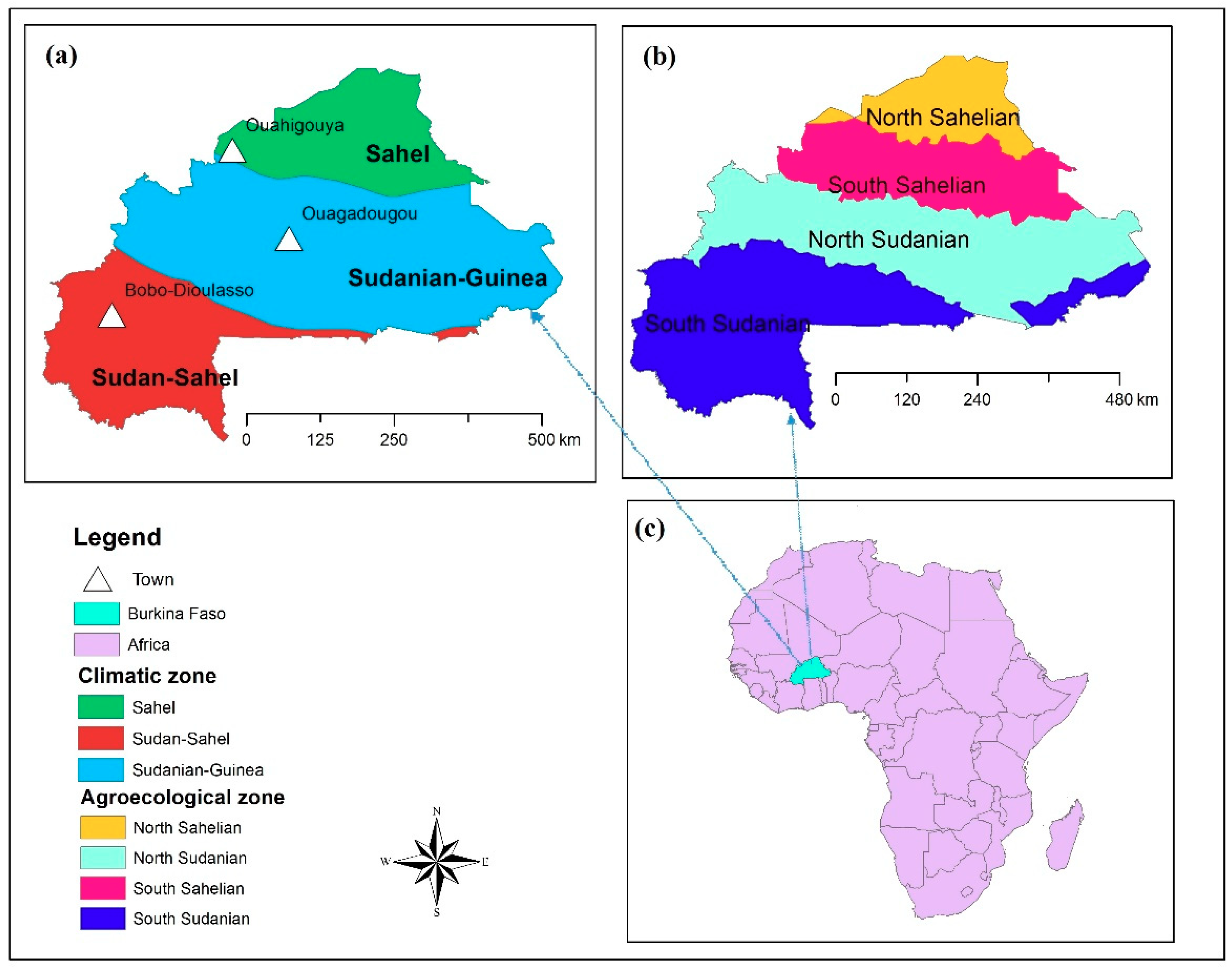
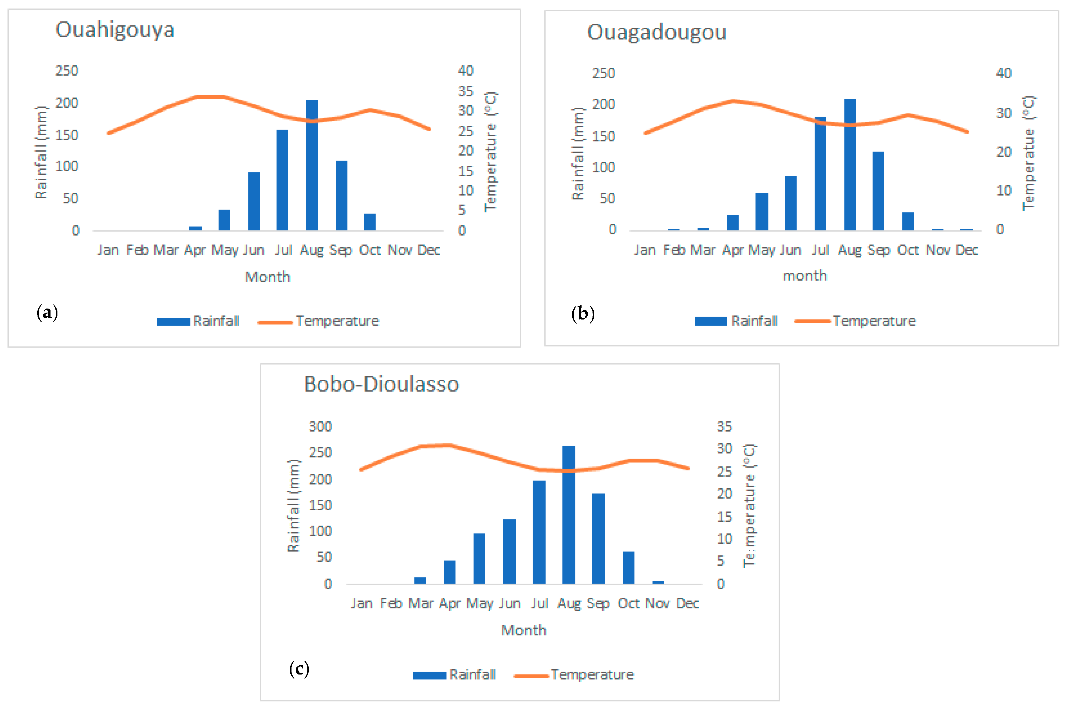
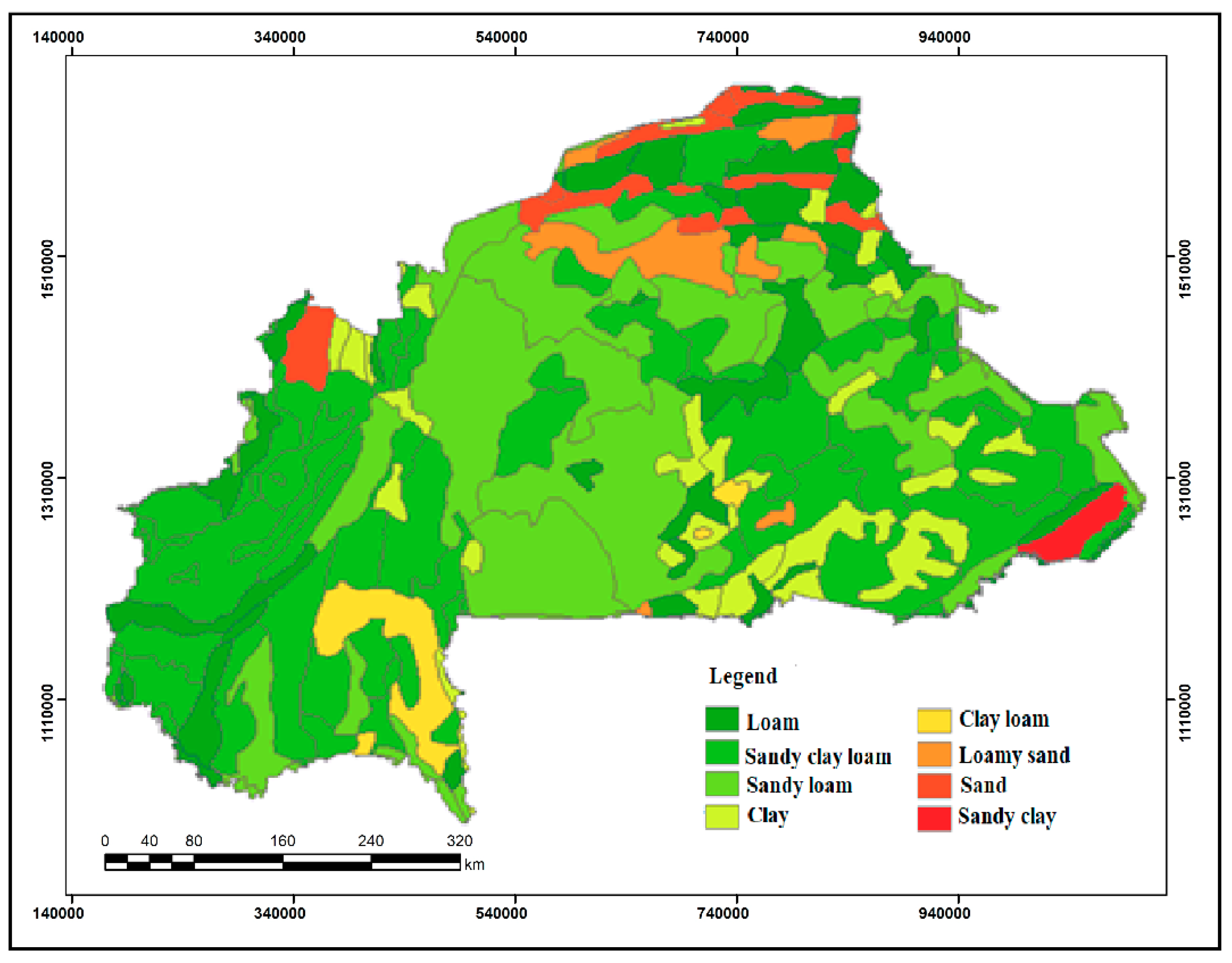
2. Study Area
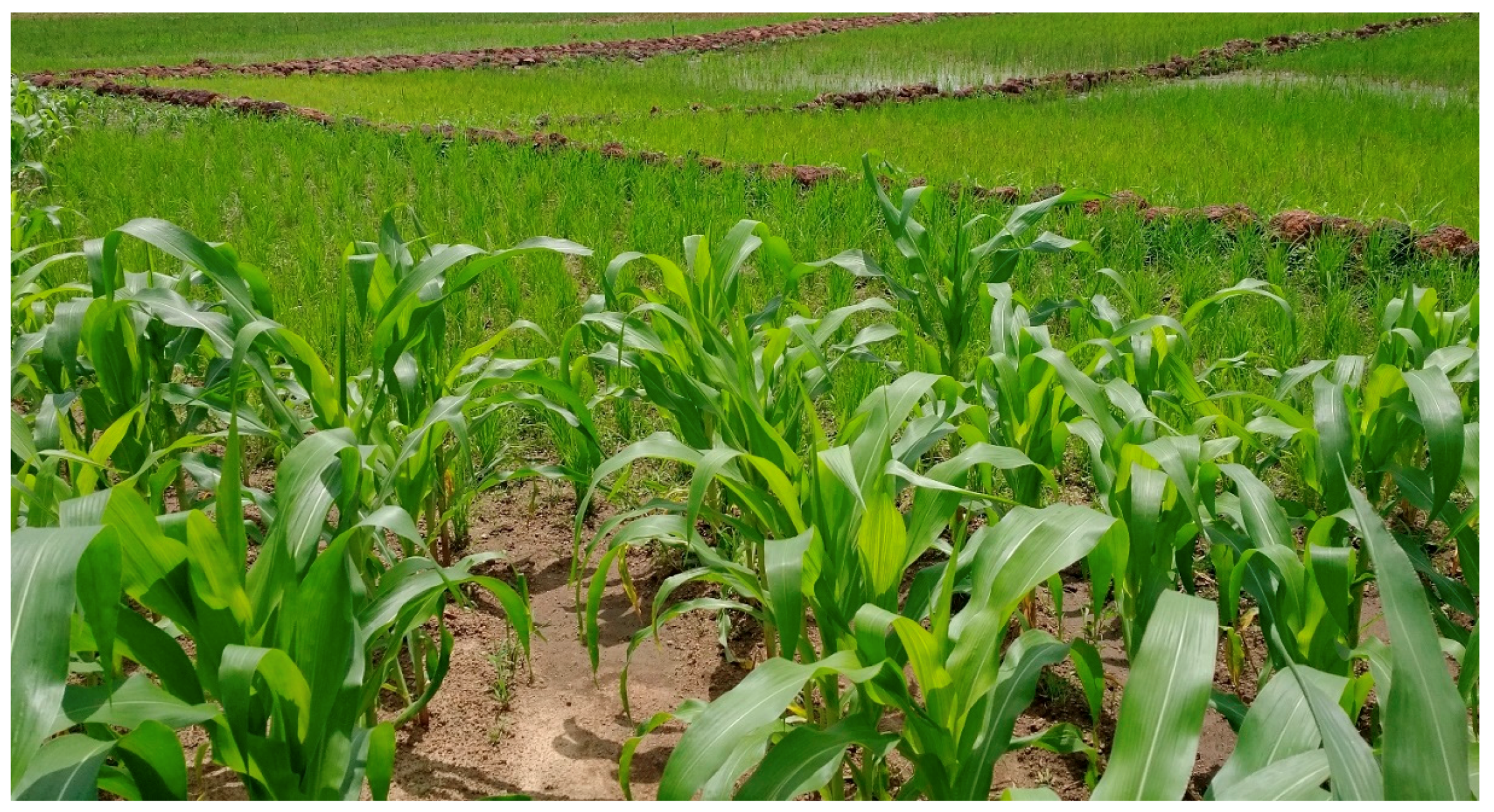
3. Soil and Water Conservation Initiatives in Burkina Faso
3.1. Types of Soil and Water Conservation Measures in Burkina Faso
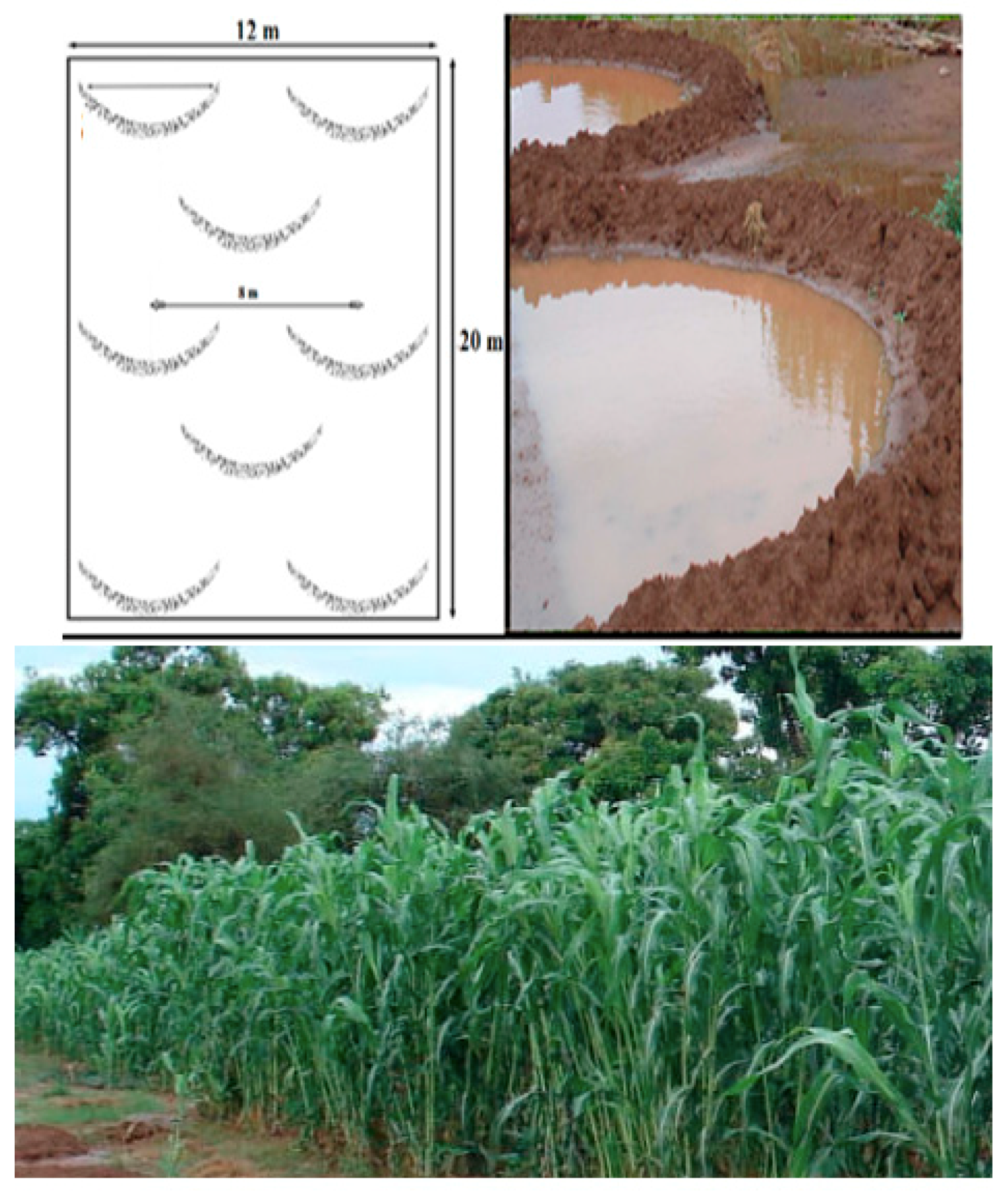
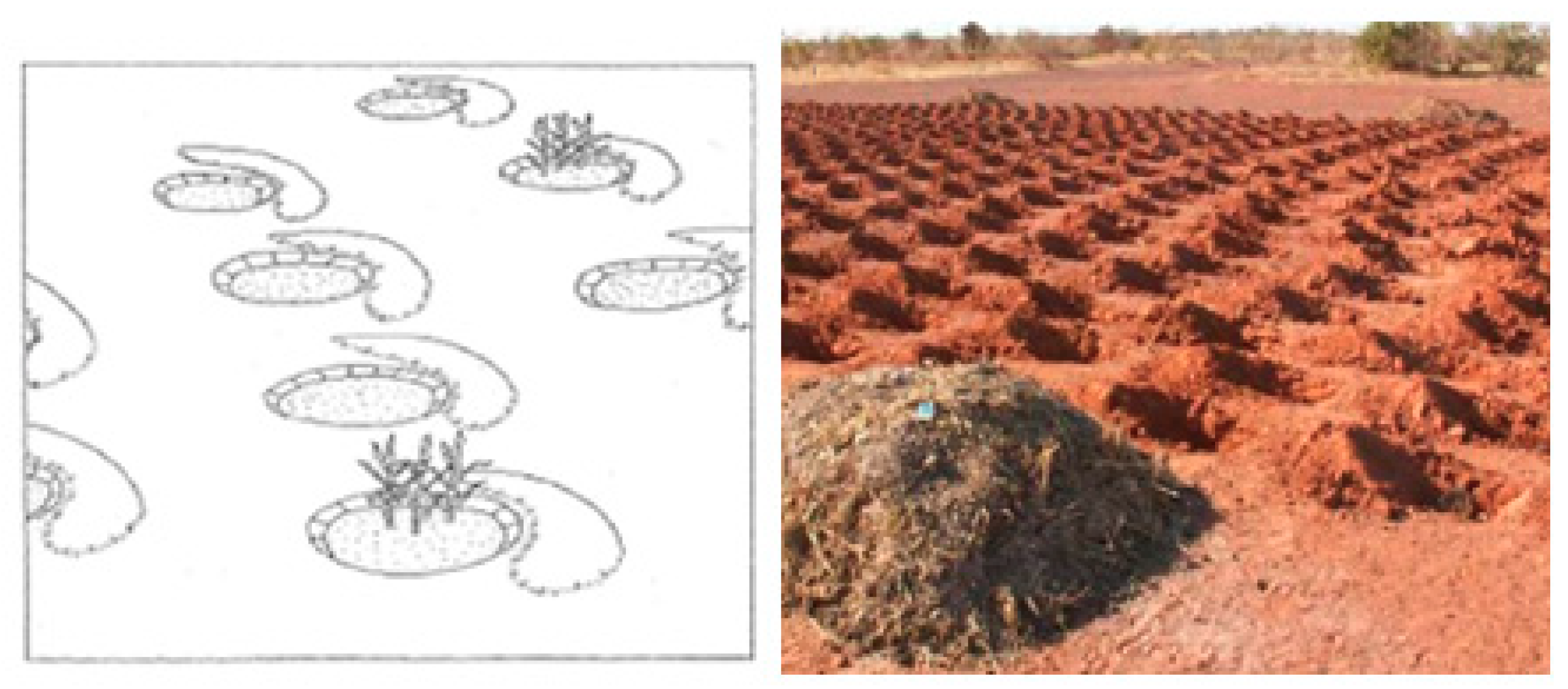
3.1.1. Half-Moons
3.1.2. Improved Traditional Planting Pits (Zai)
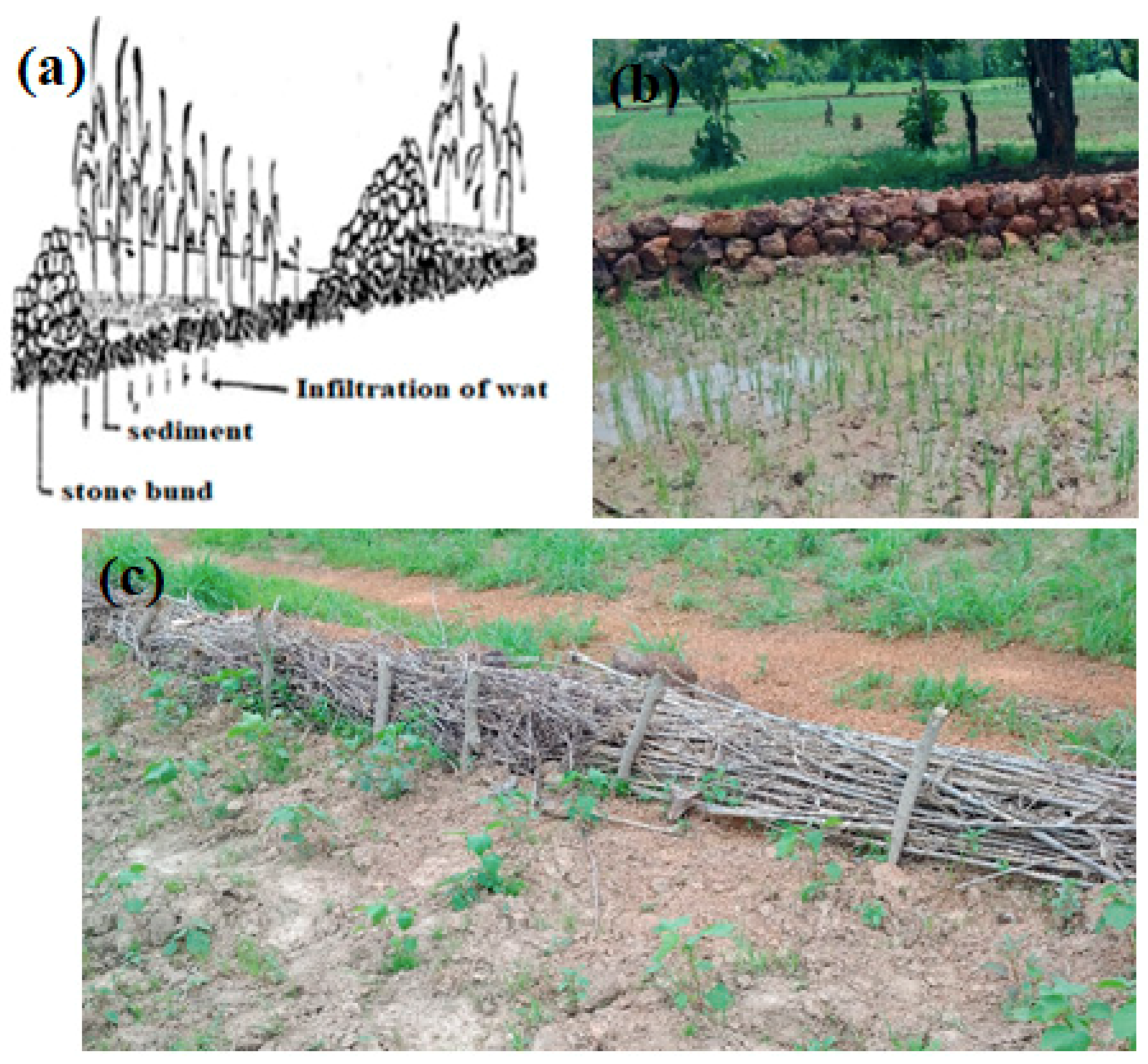
3.1.3. Stone Bunds
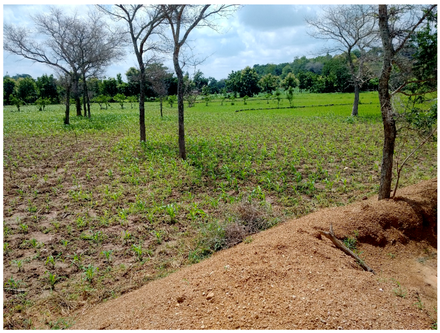
3.1.4. Agroforestry
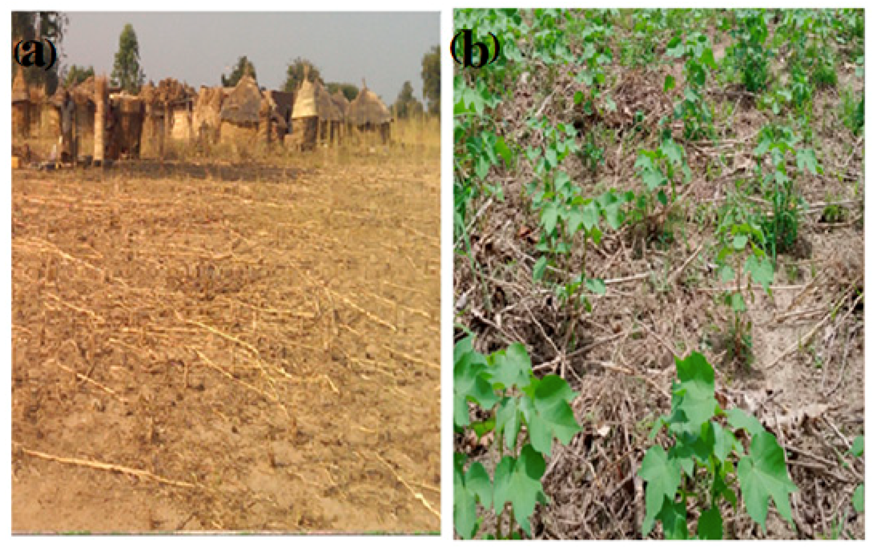
3.1.5. Mulching
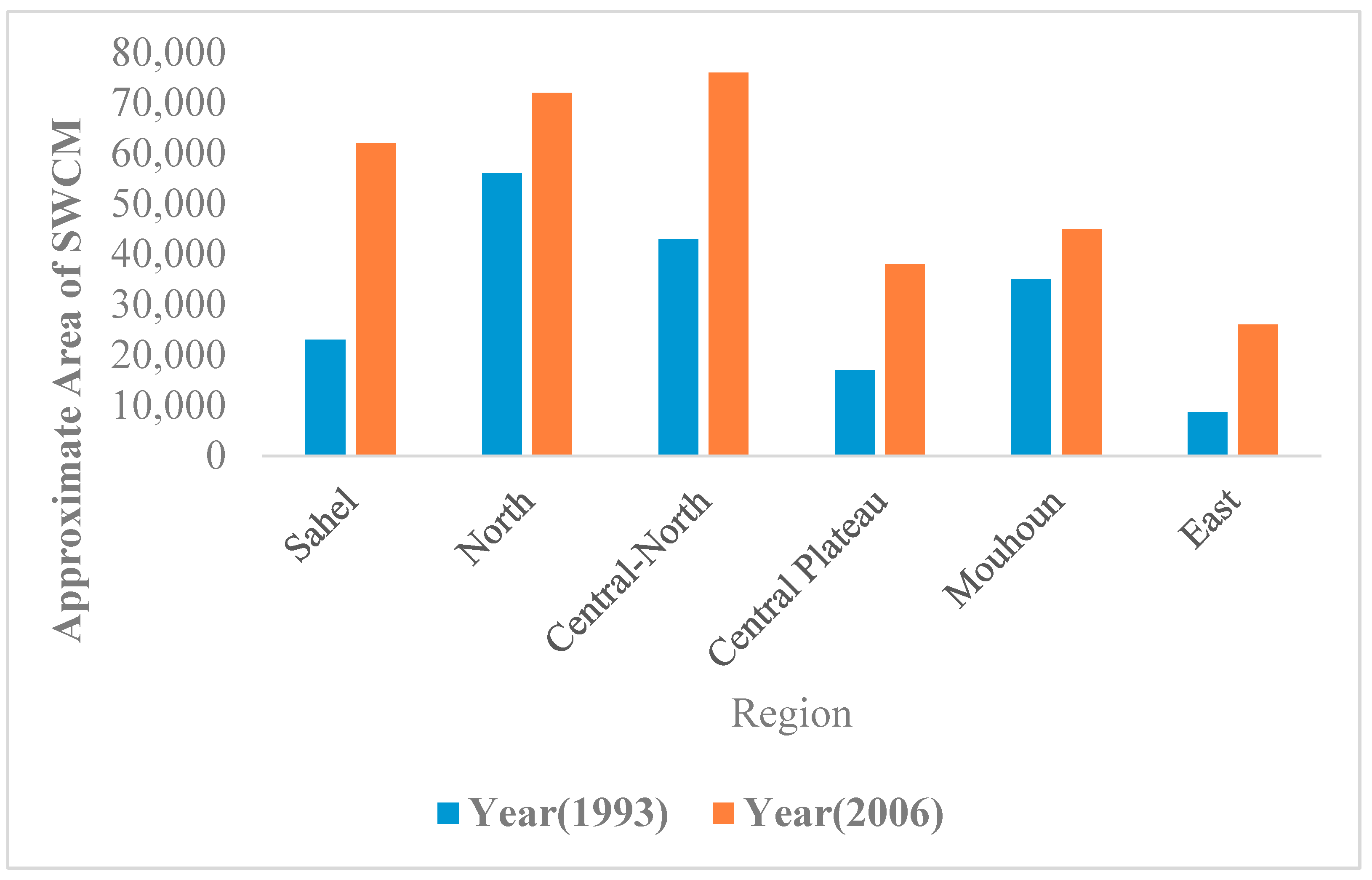
4. Soil Erosion and Sediment Yield
5. Effectiveness of the Soil and Water Conservation Measures
6. Factors That Affect Soil and Water Conservation in Burkina Faso
6.1. Migration of Work Force
6.2. Cultivation of Cash Crops
6.3. Land Tenure Security
7. Results and Discussion
8. Conclusions
Author Contributions
Acknowledgments
Conflicts of Interest
References
- Lanckriet, S.; Derudder, B.; Naudts, J.; Bauer, H.; Deckers, J.; Haile, M.; Nyssen, J.A. Political Ecology Perspective of Land Degradation in the North Ethiopian Highlands. Land Degrad. Dev. 2015, 26, 521–530. [Google Scholar] [CrossRef]
- United Nations. Millennium Development Goal; United Nations: New York, NY, USA, 2015. [Google Scholar]
- Oldeman, I. Soil Resilience and Sustainable Land Use; ISRIC: Wageningen, The Netherlands, 1994; pp. 19–36. [Google Scholar]
- ICOLD. Sedimentation and Sustainable Use of Reservoirs and River Systems; Draft Icold Bulletin; International Commission on Large Dams (ICOLD): Paris, France, 2009. [Google Scholar]
- FAO. The State of the World’s Land and Water Resources for Food and Agriculture (SOLAW): Managing Systems at Risk; Food and Agricultural Organization of the United Nations Report: Rome, Italy, 2011. [Google Scholar]
- IAEA (International Atomic Energy Agency). Guidelines for Using Fallout Radionuclides to Assess Erosion and Effectiveness of Soil Conservation Strategies; IAEA: Vienna, Austria, 2014. [Google Scholar]
- Collins, A.L.; Walling, D.E.; Sichingabula, H.; Leeks, G.J. Using 137Cs measurements to quantify soil erosion and redistribution rates for areas under different land use in the Upper Kaleya River basin, southern Zambia. Geoderma 2001, 104, 299–323. [Google Scholar] [CrossRef]
- Morgan, R.P. Soil Erosion and Conservation, 3rd ed.; Wiley: Oxford, UK, 2005; ISBN 13 9781405117814. [Google Scholar]
- Okou, F.A.Y.; Tente, B.; Bachmann, Y.; Sinsin, B. Regional erosion risk mapping for decision support: A case study from West Africa. Land Use Policy 2016, 56, 27–37. [Google Scholar] [CrossRef]
- Smith, P.; House, J.I.; Bustamante, M.; Sobocká, J.; Harper, R.; Pan, G.; West, P.C.; Clark, J.M.; Adhya, T.; Rumpel, C.; et al. Global change pressures on soils from land use and management. Glob. Chang. Biol. 2016, 22, 1008–1028. [Google Scholar] [CrossRef] [PubMed]
- Agboola, A.A.; Aiyelari, E.A. Land degradation and soil fertility decline in Africa. Afr. Soils 2000, 31, 35–53. [Google Scholar]
- Bationo, A.; Kihara, J.; Vanlauwe, B.W.; Kimetu, J. Soil organic carbon dynamics, functions and management in West African agro-ecosystems. Agric. Syst. 2007, 94, 13–25. [Google Scholar] [CrossRef]
- Sivakumar, M.V.K. Interactions between climate and desertification. Agric. For. Meteorol. 2007, 142, 143–155. [Google Scholar] [CrossRef]
- Cobo, J.G.; Dercon, G.; Cadisch, G. Nutrient balances in African land use systems across different spatial scales: A review of approaches, challenges and progress. Agric. Ecosyst. Environ. 2010, 136, 1–15. [Google Scholar] [CrossRef]
- Lal, R. Soil degradation by erosion. Land Degrad. Dev. 2001, 12, 519–539. [Google Scholar] [CrossRef]
- Toy, T.J.; Foster, G.R.; Renard, K.G. Soil Erosion: Processes, Prediction, Measurement, and Control; John Wiley & Sons: New York, NY, USA, 2002; ISBN 071383694. [Google Scholar]
- United Nations Environmental Programme (UNEP). Global Environment Outlook 4: UNEP; UNEP: Valletta, Malta, 2012. [Google Scholar]
- IRIN. Burkina Faso: Population Growth Outstrips Economic Gains. 2009. Available online: http://www.irinnews.org/report/82501/ (accessed on 8 March 2018).
- World Population Review. Burkina Faso Population. 2018. Available online: http://worldpopulationreview.com/countries/burkina-faso-population/ (accessed on 8 March 2018).
- Lenhardt, A.; Glennie, J.; Intscher, N.; Ali, A.; Morin, G. A Greener Burkina: Sustainable Farming Techniques, Land Reclamation and Improved Livelihoods; The Overseas Development Institute: London, UK, 2014. [Google Scholar]
- Green, J. The Effects of Population Growth on Land Use; American Society of Landscape Architects: Washington, DC, USA, 2009. [Google Scholar]
- Forkuor, G.; Conrad, C.; Thiel, M.; Ullmann, T.; Zoungrana, E. Integration of optical and Synthetic Aperture Radar imagery for improving crop mapping in Northwestern Benin, West Africa. Remote Sens. 2014, 6, 6472–6499. [Google Scholar] [CrossRef]
- Zoungrana, B.J.-B.; Conrad, C.; Thiel, M.; Amekudzi, L.K.; Da, E. MODIS NDVI trends and fractional land cover change for improved assessments of vegetation degradation in Burkina Faso, West Africa. J. Arid Environ. 2018, 153, 66–75. [Google Scholar] [CrossRef]
- Bandre, P. Soil and Water Conservation Techniques in Burkina Faso; Oakland Institute: Oakland, CA, USA, 2002; pp. 30–31. [Google Scholar]
- Szabo, S. Urbanisation and Food Insecurity Risks: Assessing the Role of Human Development. Oxf. Dev. Stud. 2015, 44, 28–48. [Google Scholar] [CrossRef]
- Pimentel, D. Soil erosion: A food and environmental threat. Environ. Dev. Sustain. 2006, 8, 119–137. [Google Scholar] [CrossRef]
- Lal, R. Enhancing crop yield in the developing countries through restoration of soil organic carbon pool in agricultural lands. Land Degrad. Dev. 2006, 17, 197–209. [Google Scholar] [CrossRef]
- Pimentel, D.; Satkiewicz, P. Soil Erosion Threatens Food Production. Agriculture 2013, 3, 443–463. [Google Scholar] [CrossRef]
- Ritsema, C.J.; Van Lynden, G.W.J.; Jetten, V.G.; de Jong, S.M. Degradation. In Encyclopedia of Soils in the Environment, 1st ed.; Hillel, D., Rosenzweig, C., Powlson, D., Scow, K., Singer, M., Sparks, D., Eds.; Academic Press: Cambridge, MA, USA, 2005; pp. 370–377. [Google Scholar]
- Dialla, B.E. The Adoption of Soil Conservation Practices in Burkina Faso: The Role of Indigenous Knowledge, Social Structure and Institutional Support. Ph.D. Thesis, Iowa State University, Ames, IA, USA, 1992. [Google Scholar]
- Forkuor, G.; Hounkpatin, O.K.L.; Welp, G.; Thiel, M. High Resolution Mapping of Soil Properties Using Remote Sensing Variables in South-West Burkina Faso: A Comparison of Machine Learning and Multiple Linear Regression Models. PLoS ONE 2017, 12, e0170478. [Google Scholar] [CrossRef] [PubMed]
- Reij, C.; Tappan, G.; Smale, M. Re-greening the Sahel: Farmer-led innovation in Burkina Faso and Niger. In Millions Fed: Proven Successes in Agricultural Development; Spielman, D.J., Pandya-Lorchpp, R., Eds.; International Food Policy Research Institute: Washington, DC, USA, 2009; pp. 53–58. [Google Scholar]
- Youngers, S.D.; Bonkougou, E.G. Burkina Faso: The Project Agro-Forestier, a case study of agricultural research and extension. In Successful Development in Africa: Case Studies of Projects, Programs, and Policies; EDI Development Policy Case Series; Analytical Case Studies No. 1; The World Bank: Washington, DC, USA, 1989. [Google Scholar]
- Nyssen, J.; Clymans, W.; Poesen, J.; Vandescasteele, I.; De Baets, S.; Haregeweyn, N.; Naudts, J.; Hadera, A.; Moeyersons, J. How soil conservation affects the catchment sediment budget: A comprehensive study in the north Ethiopian highlands. Earth Surf. Process. Landf. 2009, 34, 1216–1233. [Google Scholar] [CrossRef]
- Taye, G.; Poesen, J.; Wesemael, B.; Vanmaercke, M.; Teka, D.; Deckers, J.; Haregeweyn, N. Effects of land use, slope gradient, and soil and water conservation structures on runoff and soil loss in semi-arid Northern Ethiopia. Phys. Geogr. 2013, 34, 236–259. [Google Scholar] [CrossRef]
- Descheemaeker, K.; Nyssen, J.; Rossi, J.; Poesen, J.; Haile, M.; Raes, D.; Muys, B.; Moeyersons, J.; Deckers, S. Sediment deposition and pedogenesis in exclosures in the Tigray Highlands, Ethiopia. Geoderma 2006, 132, 291–314. [Google Scholar] [CrossRef]
- Haregeweyn, N.; Poesen, J.; Deckers, J.; Nyssen, J.; Haile, M.; Govers, G.; Verstraeten, G.; Moeyersons, J. Sediment-bound nutrient export and associated costs from micro-dam catchments of Northern Ethiopia. Land Degrad. Dev. 2008, 19, 136–152. [Google Scholar] [CrossRef]
- Amsalu, A.; de Graaff, J. Farmers’ views of soil erosion problems and their conservation knowledge at Beressa watershed, central highlands of Ethiopia. Agric. Hum. Values 2006, 23, 99–108. [Google Scholar] [CrossRef]
- Tefera, B.; Sterk, G. Land management, erosion problems and soil and water conservation in Fincha’a watershed, western Ethiopia. Land Use Policy 2010, 27, 1027–1037. [Google Scholar] [CrossRef]
- Burkina Faso INDC. Intended Nationally Determined Contribution (INDC) in Burkina Faso. 2015. Available online: http://www4.unfccc.int/ndcregistry/PublishedDocuments/Burkina Faso First/INDC Burkina_ENG.version_finale.pdf (accessed on 23 February 2018).
- Hiernaux, P.; Ayantunde, A.; Kalilou, A.; Mougin, E.; Gérard, B.; Baup, F.; Grippa, M. Trends in produ ctivity of crops, fallow and rangelands in Southwest Niger: Impact of land use, management and variable rainfall. J. Hydrol. 2009, 375, 65–77. [Google Scholar] [CrossRef]
- Brandt, M.; Hiernaux, P.; Tagesson, T.; Verger, A.; Rasmussen, K.; Diouf, A.A.; Mbow, C.; Mougin, E.; Fensholt, R. Woody plant cover estimation in drylands from Earth Observation based seasonal metrics. Remote Sens. Environ. 2016, 172, 28–38. [Google Scholar] [CrossRef]
- Boffa, J.M. Agroforestry Parkland in Sub-Saharan Africa: FAO Conservation Guide 34; Food and Agriculture Organization of the United Nations: Rome, Italy, 1999. [Google Scholar]
- Callo-Concha, D.; Gaiser, T.; Webber, H.; Tischbein, B.; Müller, M.; Ewert, F. Farming in the West African Sudan Savanna: Insights in the context of climate change. Afr. J. Agric. Res. 2013, 8, 4693–4705. [Google Scholar] [CrossRef]
- Bossard, L. Regional Atlas on West Africa; OECD Publishing: Paris, France, 2009. [Google Scholar]
- Knauer, K.; Gessner, U.; Fensholt, R.; Forkuor, G.; Kuenzer, C. Monitoring agricultural expansion in Burkina Faso over 14 years with 30 m resolution time series: The role of population growth and implications for the environment. Remote Sens. 2017, 9, 132. [Google Scholar] [CrossRef]
- Hijmans, R.J.; Cameron, S.E.; Parra, J.L.; Jones, P.G.; Jarvis, A. Very high resolution interpolated climate surfaces for global land areas. Int. J. Clim. 2005, 25, 1965–1978. [Google Scholar] [CrossRef]
- Jenness, J.; Dooley, J. GIS Based Tools for Inland Acquatic Resource Management: Concept and Application Case Studies; CIFA Technical Paper 33/1; International Food Policy Research Institute: Washington, DC, USA, 2007. [Google Scholar]
- FAO. World Reference Base for Soil Resources: International Soil Classification System for Naming and Creating Legends for Soil Maps; FAO: Rome, Italy, 2015. [Google Scholar]
- Ministry of Agriculture. Climatic and Agro-ecological Zones of Burkina Faso; Ministry of Agriculture: Ouagadougou, Burkina Faso, 2017.
- Meterological Agency. Rainfall and Temperature Data of Burkina Faso; Meterological Agency: Ouagadougou, Burkina Faso, 2018.
- WOCAT. Where the Land Is Greener: Case Studies and Analysis of Soil and Water Conservation Initiatives Worldwide; CTA: Wageningen, The Netherlands, 2007. [Google Scholar]
- Critchley, W.R.S.; Reij, C.; Willcoks, T.J. Indigenous soil and water conservation: A Review of the state of knowledge and prospects for building on traditions. Land Degrad. Dev. 1994, 5, 293–314. [Google Scholar] [CrossRef]
- Pretty, J.; Shaw, P. Making soil and water conservation sustainable: From coercion and control to partnerships and participation. Land Degrad. Dev. 1997, 8, 39–58. [Google Scholar] [CrossRef]
- Reij, C. Indigenous Soil and Water Conservation in Africa; IIED Gatekeeper Series No. 27; IIED: London, UK, 1991. [Google Scholar]
- Critchley, W.R.S.; Graham, O. Looking after Our Land. New Approaches to Soil and Water Conservation in Dryland Africa; Oxfam Publication: Oxford, UK, 1991. [Google Scholar]
- Pacey, A.; Cullis, A. Rainwater Harvesting; Intermediate Technology Publications: London, UK, 1986. [Google Scholar]
- Sawadogo, H. Using soil and water conservation techniques to rehabilitate degraded lands in Northwestern Burkina Faso. Int. J. Agric. Sustain. 2011, 9, 120–128. [Google Scholar] [CrossRef]
- Dabiré, F. Revolutionary Conservation: Villages Successfully Use Stones against Erosion. West Africa, September 1989; 11–17. [Google Scholar]
- Reij, C. Soil and Water Conservation in Sub-Saharan Africa: The Need for a Bottom-Up Approach; IFAD: Rome, Italy, 1987. [Google Scholar]
- Warren, D.M.; Cashman, K. Indigenous Knowledge for Agriculture and Rural Development; Sustainable Agriculture Programme, International Institute for Environment and Development (IIED): London, UK, 1988. [Google Scholar]
- Cashman, K. Agricultural research centers and indigenous knowledge systems: In a worldwide perspective: Where do we go from here? In Indigenous Knowledge Systems: Implications for Agriculture and International; Warren, D.M., Slikkerveer, L.J., Titilola, S.O., Eds.; Studies in TSC Series, No. 11; TSC Program; AGRIS: Rome, Italy, 1989. [Google Scholar]
- Richards, P. Indigenous agricultural knowledge and international agricultural research. In Indigenous Knowledge Systems for Agriculture and Rural Development: The CIKARD Inaugural Lectures (Studies in TSC Series, No. 13); Richards, P., Slikkerveer, L.J., Phillips, A.O., Eds.; Iowa State University: Ames, IA, USA, 1989; pp. 4–18. [Google Scholar]
- Gladwin, C. Ethnographic Decision Tree Modeling: Qualitative Research Methods Series; SAGE Publications: London, UK, 1989. [Google Scholar]
- Sawadogo, S.; Ouattara, K.; Ouédraogo, I.; Balima, M.; Sawadogo, M.; Traoré, S.; Gowing, J. Burkina Faso: Cradle of Farm Scale Technologies. In Water Harvesting in Sub-Saharan Africa; Taylor & Francis: Milton Park, Didcot, UK, 2012. [Google Scholar]
- Zougmoré, R.; Jalloh, A.; Tioro, A. Climate-smart soil water and nutrient management options in semiarid West Africa: A review of evidence and analysis of stone bunds and zaï techniques. Agric. Food. Secur. 2014, 3, 16. [Google Scholar] [CrossRef]
- Serme, I.; Ouattara, K.; Logah, V.; Taonda, J.B.; Pale, S.; Quansah, C.; Abaidoo, C.R. Impact of tillage and fertility management options on selected soil physical properties and sorghum yield. Int. J. Biol. Chem. Sci. 2015, 9, 1154–1170. [Google Scholar] [CrossRef]
- Sawadogo, H.; Bock, L.; Lacroix, D.; Zombre, N.P. Restauration des potentialites de sols dégradés à l’aide du zaı et du compost dans le Yatenga (Burkina Faso). Biotechnol. Agron. Soc. Environ. 2008, 12, 279–290. (In French) [Google Scholar]
- Sawadogo, H. Fertilisation Organique et Phosphate’e en Systeme de Culture zaı, en Milieu Soudano Sahelien du Burkina Faso. Ph.D. Thesis, Faculte Universitaire des Sciences Agronomiques de Gembloux, Gembloux, Belgium, 2006. (In French). [Google Scholar]
- Zougmoré, R.; Kaboré, D.; Lowenberg-Deboer, J. Optimal Spacing of Soil Conservation Barriers: Example of Rock Bunds in Burkina Faso. Agric. J. 2000, 92, 361–368. [Google Scholar]
- Zougmoré, R.B. Integrated Water and Nutrient Management for Sorghum Production in Semi-Arid Burkina Faso. Ph.D. Thesis, Wageningen University, Wageningen, The Netherlands, 2003. [Google Scholar]
- Zougmoré, R.; Mando, A.; Ringersma, J.; Stroosnijder, L. Effect of combined water and nutrient management on runoff and soil erosion in semi-arid Burkina Faso. Soil Use Manag. 2003, 19, 257–264. [Google Scholar] [CrossRef]
- Zougmoré, R.; Zida, Z.; Kambou, N.F. Réhabilitation des sols dégradés: Rôles des amendements dans le succès des techniques de demi-lune et de Zaï au Sahel. Bull. Rés. Eros. 1999, 19, 536–550. (In French) [Google Scholar]
- CPP. Burkina Faso—Sub-Programme of the Nothern Region under Partnership Programme for Sustainable Land Management. 2007. Available online: https://www.thegef.org/project/cpp-burkina-faso-sub-programme-northern-region-under-partnership-programme-sustainable-land (accessed on 13 April 2018).
- Reij, C.; Tappan, G.; Belemviré, A. Changing land management practices and vegetation in the Central Plateau of Burkina Faso (1968–2002). J. Arid Environ. 2005, 63, 642–659. [Google Scholar] [CrossRef]
- Kaboré, P.D.; Reij, C. The Emergence and Spreading of an Improved Traditional Soil and Water Conservation in Burkina Faso; Environment and Production Technology Division Discussion Paper; International Food Policy Research Institute: Washington, DC, USA, 2004. [Google Scholar]
- Ouedraogo, A.; Sawadogo, H. Three Models of Extension by Farmer Innovators in Burkina Faso. In Farmer Innovation in Africa: A Source of Inspiration for Agricultural Development; Reij, C., Waters-Bayer, A., Eds.; Earthscan: London, UK, 2001; pp. 213–217. [Google Scholar]
- Motis, T.; D’Aiuto, C.; Lingbeek, B. Zai Pit System; ECHO Technical Note 78; ECHO: North Fort Myers, FL, USA, 2013. [Google Scholar]
- Ouédraogo, M.; Kaboré, V. The “zai”: A traditional technique for the rehabilitation of degraded land in the Yatenga, Burkina Faso. In Sustainig the Soil. Indigenous Soil and Water Conservation in Africa; Reij, C., Scoones, I., Toulmin, C., Eds.; IIED: London, UK, 1996; pp. 80–92. [Google Scholar]
- Botoni, E.; Reij, C. Silent Transformation of Environment and Production Systems in the Sahel: Impacts of Public and Private Investments in Natural Resource Management; IFPRI Discussion Paper; CILSS: Ouagadougou, Burkina Faso, 2009; p. 43. [Google Scholar]
- Sawadogo, H.; Hien, F.; Sohoro, A.; Kambou, F. Pits for trees: How farmers in semi-arid Burkina Faso increase and diversify plant biomas. In Farmer Innovation in Africa: A Source of Inspiration for Agricultural Development; Reij, C., Waters-Bayer, A., Eds.; Earthscan: London, UK, 2001. [Google Scholar]
- Maatman, A.; Sawadogo, H.; Scheigman, C.; Ouedraogo, A. Application of rock bunds and Zai in the North-West region of Burkina Faso: Study of its impact on household level by using linear programing model. Neth. J. Agric. Sci. 1998, 46, 123–136. [Google Scholar]
- Kessler, J.J.; Geerling, C. Profile Environmental du Burkina Faso; Agricultural University of Wageningen, Department of Nature Conservation: Wageningen, The Netherlands, 1994. [Google Scholar]
- Wright, P. La conservation des eaux et des sols par les paysans. In Technologies Appropriees Pour les Paysans des Zones Semi-Arides de L’afrique de l’Ouest; Ohm, W., Ed.; Purdue University: West Lafayette, IN, USA, 1985. (In French) [Google Scholar]
- Zougmoré, R.; Mando, A.; Stroosnijder, L. Rôle des nutriments dans le succès des techniques de conservation des eaux et des sols (cordons pierreux, bandes enherbées, zaï et demi-lunes) au Burkina Faso. Sécheresse 2004, 15, 41–48. (In French) [Google Scholar]
- Schönbrodt-Stitt, S.; Behrens, T.; Schmidt, K.; Shi, X.; Scholten, T. Degradation of cultivated bench terraces in the Three Gorges Area: Field mapping and data mapping. Ecol. Indic. 2013, 34, 478–493. [Google Scholar] [CrossRef]
- Nyssen, J.; Poessen, J.; Gebremichael, D.; Vancampenhout, K.; D’aes, M.; Yihdego, G.; Govers, G.; Leirs, H.; Moeyersons, J.; Naudts, J.; et al. Interdisciplinary on-site evaluation of stone bunds to control soil erosion on cropland in northern Ethiopia. Soil Tillage Res. 2007, 94, 151–163. [Google Scholar] [CrossRef]
- Sabet, Y. Techniques pour la Conservation des Eaux de Ruissellement et la Restauration des sols au Niger; Forestry Project IDA/FAC/CCCE; Ministry of Agriculture and the Environment: Niamey, Niger, 1989; p. 57. (In French)
- Zougmoré, R.; Mando, A.; Stroosnijder, L. Soil nutrient and sediment loss as affected by erosion barriers and nutrient source in semi-arid Burkina Faso. Arid Land Res. Manag. 2009, 23, 85–101. [Google Scholar] [CrossRef]
- Zoungrana, J.B. Vegetation Dynamics in the Southwest of Burkina Faso in Response to Rainfall Variability and Land Use. Ph.D. Thesis, Kwame Nkrumah University of Science and Technology, Kumasi, Ghana, 2016. [Google Scholar]
- Belemvire, A. Impact de la Conservation de l’Eau et des Sols sur la Regeneration Naturelle Assistée. Developpement Rural et Environment au Burkina Faso: La Rehbilitation de la Capacite des Terroirs sur la Partie Nord du Plateau Central Entre 1980 et 2000; Rapport de Travail No. 1; Conseil National pour la Gestion de I’ Environment: Ouagadougou, Burkina Faso, 2003. (In French) [Google Scholar]
- Mando, A.; Brussaard, L.; Stroonsnijder, L. Termites and mulch mediated rehabilitation of vegetation on crusted soil in West Africa. Rest. Ecol. 1999, 7, 33–41. [Google Scholar] [CrossRef]
- Schmengler, A.C. Modeling Soil Erosion and Reservoir Sedimentation at Hillslope and Catchment Scale in Semi-Arid Burkina Faso. Ph.D. Thesis, University of Bonn, Bonn, Germany, 2011. [Google Scholar]
- Hajigholizadeh, M.; Melesse, A.M.; Fuentes, H. Erosion and Sediment Transport Modelling in Shallow Waters: A Review on Approaches, Models and Applications. Int. J. Environ. Res. Public Health 2018, 15, 518. [Google Scholar] [CrossRef] [PubMed]
- White, S. Sediment yield prediction and modelling. Hydrol. Process. 2005, 19, 3053–3057. [Google Scholar] [CrossRef]
- Oostveen, N. Modelling Soil Erosion and Reservoir Sedimentation Using USLE Case Study of The Tandjari Catchment in the Gourma Region. Bachelor’s Thesis, Van Hall Larenstein University of Applied Sciences, Velp, The Netherlands, 2017. [Google Scholar]
- Visser, S.M.; Sterk, G.; Karssenberg, D. Modelling water erosion in the Sahel: Application of a physically based soil erosion model in a gentle sloping environment. Earth Surf. Process. Landf. 2005, 30, 1547–1566. [Google Scholar] [CrossRef]
- De Hipt, F.O.; Diekkrüger, B.; Steup, G.; Yira, Y.; Hoffmann, T.; Rode, M. Applying SHETRAN in a tropical west African catchment (Dano, Burkina Faso)—Calibration, validation, uncertainty assessment. Water 2017, 9, 101. [Google Scholar] [CrossRef]
- Kinnel, P.I. Event soil loss, runoff and the Universal Soil Loss Equation family of models: A review. J. Hydrol. 2010, 385, 384–397. [Google Scholar] [CrossRef]
- Boardman, J. Soil erosion science: Reflections on the limitations of current approaches. Catena 2006, 68, 73–86. [Google Scholar] [CrossRef]
- Flanagan, D.C.; Livingstone, S.J. Water Erosion Prediction Project: User Summary; NSERL Report No. 11; USDA-ARS National Soil Erosion Research Laboratory: West Lafayette, IN, USA, 1995.
- Alberts, E.E.; Nearing, M.A.; Weltz, M.A.; Risse, L.M.; Pierson, F.B.; Zhang, X.C.; Laflen, J.M.; Simanton, J.J. Soil component. In USDA-Water Erosion Prediction Project (WEPP). Hillslope Profile and Watershed Model Documentation; Flanagan, D.C., Nearing, M.A., Eds.; NSERL Report No. 10; USDA-ARS National Soil Erosion Research Laboratory: West Lafayette, IN, USA, 1995. [Google Scholar]
- Beven, K. Changing ideas in hydrology—The case of physically-based models. J. Hydrol. 1989, 105, 157–172. [Google Scholar] [CrossRef]
- Zougmoré, R.; Mando, A.; Stroosnijder, L. Effect of soil and water conservation and nutrient management on the soil-plant water balance in semi-arid Burkina Faso. Agric. Water Manag. 2004, 65, 103–120. [Google Scholar] [CrossRef]
- Lamachère, J.M.; Serpanie, G. Valorisation agricole des eaux de ruissellement et lutte contre l’érosion sur champs cultives en mil en zone soudano-sahélienne Burkina Faso—Province du Yatenga—Région de Bidi. In Utilisation Rationnelle de L’eau et des Petits Bassins Versants en Zone Aride; J. Libbey Eurotext: Paris, France, 1990; pp. 88–104. (In French) [Google Scholar]
- Karambiri, H.; Ribolzi, O. Identification of Sediment Sources in a Small Grazed Sahelian Catchment, Burkina Faso; IAHS-AISH P291; IAHS Press: Wallingford, CT, USA, 2005. [Google Scholar]
- Dumas, R.; Claude, J. Mesures des Transports Solides de la Volta Blanche au site de Niaogho. Campagne 1977; ORSTROM: Ouagadougou, Burkina Faso, 1977. (In French) [Google Scholar]
- H.E.R. Service Hydrologie. Etude Hydrologique de la Kompienga: Campagne de Measures 1980; World Bank: Washington, DC, USA, 1981. (In French) [Google Scholar]
- Mietton, M. Méthodes et efficacité de la lutte contre l’érosion hydrique au Burkina Faso. Cah ORSTOM Sér. Pédol. 1986, 12, 181–196. [Google Scholar]
- Zougmoré, R.; Mando, A.; Stroosnijder, L.; Ouédraogo, E. Economic benefits of combining soil and water conservation measures with nutrient management in semiarid Burkina Faso. Nutr. Cycl. Agroecosyst. 2004, 70, 261. [Google Scholar] [CrossRef]
- Frankl, A.; Poesen, J.; Deckers, J.; Haile, M.; Nyssen, J. Gully head retreat rates in the semi-arid highlands of Northern Ethiopia. Geomorphology 2012, 173–174, 185–195. [Google Scholar] [CrossRef]
- Frankl, A.; Poesen, J.; Haile, M.; Deckers, J.; Nyssen, J. Quantifying long-term changes in gully networks and volumes in dryland environments: The case of Northern Ethiopia. Geomorphology 2013, 201, 254–263. [Google Scholar] [CrossRef]
- Frankl, A.; Nyssen, J.; De Dapper, M.; Haile, M.; Billi, P.; Munro, N.; Deckers, J.; Poesen, J. Linking long-term gully and river channel dynamics to environmental change using repeat photography (North Ethiopia). Geomorphology 2011, 129, 238–251. [Google Scholar] [CrossRef]
- Sawadogo, H. Impact des Aménagements sur les Systèmes de Production, les Rendements et la Sécurité Alimentaire des Exploitations Agricoles; Etude Plateau Central. Rapport de Travail No. 2; CILSS: Ouagadougou, Burkina Faso, 2003. (In French) [Google Scholar]
- Ouedraogo, I. Land Use Dynamics and Demographic Change in Southern Burkina Faso. Ph.D. Thesis, Swedish University of Agricultural Sciences, Uppsala, Sweden, 2010. [Google Scholar]
- Bayala, J.; Sileshi, G.W.; Kalinganire, A.; Tchoundjeu, Z.; Sinclair, F.; Garrity, D. Cereal yield response to conservation agriculture practices in drylands of West Africa: A quantitative synthesis. J. Arid Environ. 2012, 78, 13–25. [Google Scholar] [CrossRef]
- Onyango, S. Using Agroforestry and Forestry Management to Mitigate and Adapt to Climate Change in Cassou Area, Burkina Faso. Agroforestry World, 2015. Available online: http://blog.worldagroforestry.org/index.php/2015/06/01/using-agroforestry-and-forestry-management-to-mitigate-and-adapt-to-climate-change-in-cassou-area-burkina-faso/ (accessed on 15 May 2017).
- Alliance for Food Sovereignty in Africa (AFSA). Soil Water Conservation Techniques in Burkina Faso. 2015. Available online: https://www.oaklandinstitute.org/soil-and-water-conservation (accessed on 8 November 2017).
- Reij, C.; Thiombiano, T. Developpment Rural et Environment au Burkina Faso: La Rehabilitation de la Capacite Productive des Terroirs sur la Partie nord du Plateau Central Entre 1980 et 2001; Ambassade des Pays-Bas: Ouagadougou, Burkina Faso, 2003. (In French) [Google Scholar]
- Grimaldi, S.; Angeluccetti, I.; Coviello, V.; Vezza, P. Cost-effectiveness of soil and water conservation measures on the catchment sediment budget—The Laaba Watershed case study, Burkina Faso. Land Degrad. Dev. 2015, 26, 737–747. [Google Scholar] [CrossRef]
- Verstraeten, G.; Poesen, J.; De Vente, J.; Koninckx, X. Sediment variability in Spain: A quantitative and semi-quantitative analysis using reservoir sedimentation rates. Geomorphology 2003, 50, 327–348. [Google Scholar] [CrossRef]
- Tamene, L.; Park, S.J.; Dikau, R.; Vlek, P.L.G. Reservoir siltation in the semi-arid highlands of northern Ethiopia: Sediment yield-catchment area relationship and a semi-quantitative approach for predicting sediment yield. Earth Surf. Process. Landf. 2006, 31, 1364–1383. [Google Scholar] [CrossRef]
- Beauchemin, C.; Schoumaker, B. Migration to Cities in Burkina Faso: Does the Level of Development in Sending Areas Matter? World Dev. 2005, 33, 1129–1152. [Google Scholar] [CrossRef]
- Black, R.; Bennett, S.R.G.; Thomas, S.M.; Beddington, J. Climate change: Migration as adaptation. Nature 2011, 478, 447–449. [Google Scholar] [CrossRef] [PubMed]
- Scheffran, J.; Marmer, E.; Sow, P. Migration as a contribution to resilience and innovation in climate adaptation: Social networks and co-development in Northwest Africa. Appl. Geogr. 2012, 33, 119–127. [Google Scholar] [CrossRef]
- Anarfi, J.; Kwankye, S.; Ababio, O.-M.; Tiemoko, R. Migration from and to Ghana (A Background Paper); Development Research Centre on Migration, Globalization and Poverty: University of Sussex, Brighton, UK, 2003. [Google Scholar]
- Wouterse, F. Migration in Rural Burkina Faso; CUL Initiatives in Publishing: Ithaca, NY, USA, 2007. [Google Scholar]
- Ouédraogo, M.; Barry, S.; Zougmoré, R.; Partey, S.; Somé, L.; Baki, G. Farmers’ Willingness to Pay for Climate Information Services: Evidence from Cowpea and Sesame Producers in Northern Burkina Faso. Sustainability 2018, 10, 611. [Google Scholar] [CrossRef]
- Millennium Ecosystem Assessment (MEA). Ecosystem and Human Well-Being: Desertification Synthesis; Island Press: Washington, DC, USA, 2005. [Google Scholar]
- McIntyre, B.; Herren, H.; Wakhungu, J.; Watson, R. Agriculture at a Crossroads: International Assessment of Agricultural Knowledge; Science and Technology for Development (IAASTD): Washington, DC, USA, 2009. [Google Scholar]
- Lester, M.P. Half-Moon Farming Nourishes Crops in Burkina Faso. 2016. Available online: https://reliefweb.int/report/burkina-faso/half-moon-farming-nourishes-crops-burkina-faso (accessed on 7 March 2018).
- Lee, L.K. The Impacts of Landownership Factors on Soil Conservation. Am. J. Agric. Econ. 1983, 65, 63–67. [Google Scholar] [CrossRef]
- Besley, T. Property Rights and Investments Incentives: Theory and Evidence from Ghana. J. Political Econ. 1995, 103, 903–937. [Google Scholar] [CrossRef]
- Feder, G.; Just, R.E.; Zilberman, D. Adoption of Agricultural Innovations in Developing Countries. Econ. Dev. Cult. Chang. 1985, 33, 255–298. [Google Scholar] [CrossRef]
- Li, G.; Rozelle, S.; Brandt, L. Tenure, Land Rights and Farmer Investment Incentives in China. Agric. Econ. 1998, 19, 63–71. [Google Scholar] [CrossRef]
- Lee, L.K.; Stewart, W.H. Landownership and the Adoption of Minimum Tillage. Am. J. Agric. Econ. 1983, 65, 256–264. [Google Scholar] [CrossRef]
- Barbier, B.; Yacouba, H.; Karambiri, H.; Zoromé, M.; Somé, B. Human Vulnerability to Climate Variability in the Sahel: Farmers’ Adaptation Strategies in Northern Burkina Faso. Environ. Manag. 2009, 43, 790–803. [Google Scholar] [CrossRef] [PubMed]
- Morris, J.; Barron, J. Agricultural Water Management Technology Expansion and Impact on Crop Yields in Northern Burkina Faso (1980–2010): A Review; R4D Series 10; CGIAR Challenge Program on Water and Food: Colombo, Sri Lanka, 2014. [Google Scholar]
- International Fund for Agricultural Development (IFAD). Burkina Faso—Programme Spécial Conservation des Eaux et des Sols—Agroforesterie (PS CES/AGF); Rapport d’Évaluation Intermédiaire, N°1471-BF; IFAD: Rome, Italy, 2004. [Google Scholar]
- Mahrh, D. Resultats Définitifs de la Campagne Agricole 2004/2005 (EPA); Ministere de L’agriculture Ressources Halieutiques: Ouagadougou, Burkina Faso, 2006. (In French)
- Auerswald, K.; Schimmack, W. Element-pool balances in soils containing significant rock fragments. Catena 2000, 40, 279–290. [Google Scholar] [CrossRef]
- Poesen, J.; Lavee, H. Rock fragments in topsoil: Significance and processes. Catena 1994, 23, 1–28. [Google Scholar] [CrossRef]
- Poesen, J. Surface sealing as influenced by slope angle and position of simulated stones in the toplayer of loose sediments. Earth Surf. Process. Landf. 1994, 11, 1–10. [Google Scholar] [CrossRef]


| Name of Initiative | Year of Implementation | Objective | SWC Measures Implemented | Area of Implementation |
|---|---|---|---|---|
| Agrarian Land Re-organization (ALR) | 1984 | Tenure security | Agroforestry (wind breaks), stone bund, zai | Nationwide |
| Five-year Popular Development Program | 1986 | Environmental conservation, protection, and restoration | Stone bund, zai, half-moon and agroforestry | Nationwide |
| National Program for Combating Desertification (PNLCD) | 1986 | Conservation of natural resources | Mulching, agroforestry, zai and half-moon | Nationwide |
| Program Sahel Burkina (PSB) & Combating Desertification in Burkina Faso (LUCODEB) | 1992 | Restoration of soil and combat desertification | Zai and half-moon | Sahel and Sudan-Sahel |
| National Program for the Management of Rural Areas (PNGT) | 1992 | Control and reverse the process of land degradation | Agroforestry, zai, half-moon and mulching | Nationwide |
| Village Forestry | 1997 | Reduce excessive woodcutting and restore damaged eco-systems | Agroforestry | Nationwide |
| SWC | Year of Implementation | Climatic Zone Commonly Found | Purpose |
|---|---|---|---|
| half-moon (see Section 3.1.1) | 1958 | Sahel and Sudan-Sahel | Collects run-off water and increase infiltration |
| zai (Section 3.1.2) | 1980 | Some part of Sahel and part of Sudan-Sahel | Rehabilitates barren and highly degraded soils |
| stone bund (Section 3.1.3) | Late 1970s and early 1980s | Sahel, Sudan-Sahel, and Sudan-Guinea | Water harvesting technique, reduces runoff and improves infiltration |
| agroforestry (Section 3.1.4) | 1970 | Sahel, Sudan-Sahel, and Sudan-Guinea | Improves soil fertility and increase crop production |
| mulching (Section 3.1.5) | Not known | Mostly in the Sudan-Sahel | Fertilizing the soil and attracts termites, which dig holes into the soil with the effect of increasing soil porosity and permeability |
| Period | Type of SWCM | Town/Province/Region | Sorghum Yield (kg ha−1) | Reference |
|---|---|---|---|---|
| 2004–2006 | zai | Togou | 428–482 | [137] |
| 2006–2008 | zai | Leeba/Yatenga | 900–1200 | [58] |
| 2006–2008 | stone bund | Leeba | 700–1100 | [58] |
| 1984–2004 | half-moon | Northwest | 1400–2000 | [58] |
| 1986– | zai | - | 500–1000 | [138] |
| 1982–1984 | stone bunds | North | Increment of 100 annually | [70] |
| 1980–1988 | zai/stone bund/half-moon | North and Sahel | 600–700 | [82] |
| 1986–2000 | zai/half-moon | sahel | 1000–1500 | [85,100] |
| 1984–2001 | zai/stone bunds/half-moon | Centre-north/North | 611–793 | [71,73] |
| 1975–1985 | zai | Central plateau | 400–500 | [118] |
© 2018 by the authors. Licensee MDPI, Basel, Switzerland. This article is an open access article distributed under the terms and conditions of the Creative Commons Attribution (CC BY) license (http://creativecommons.org/licenses/by/4.0/).
Share and Cite
Nyamekye, C.; Thiel, M.; Schönbrodt-Stitt, S.; Zoungrana, B.J.-B.; Amekudzi, L.K. Soil and Water Conservation in Burkina Faso, West Africa. Sustainability 2018, 10, 3182. https://doi.org/10.3390/su10093182
Nyamekye C, Thiel M, Schönbrodt-Stitt S, Zoungrana BJ-B, Amekudzi LK. Soil and Water Conservation in Burkina Faso, West Africa. Sustainability. 2018; 10(9):3182. https://doi.org/10.3390/su10093182
Chicago/Turabian StyleNyamekye, Clement, Michael Thiel, Sarah Schönbrodt-Stitt, Benewinde J.-B. Zoungrana, and Leonard K. Amekudzi. 2018. "Soil and Water Conservation in Burkina Faso, West Africa" Sustainability 10, no. 9: 3182. https://doi.org/10.3390/su10093182
APA StyleNyamekye, C., Thiel, M., Schönbrodt-Stitt, S., Zoungrana, B. J.-B., & Amekudzi, L. K. (2018). Soil and Water Conservation in Burkina Faso, West Africa. Sustainability, 10(9), 3182. https://doi.org/10.3390/su10093182