Article

The Change Mechanism of Human-Environment Interactions from the Perspective of Contextualization: A Case Study of the Honghe Hani Rice Terraces as a World Cultural Heritage Site

1
School of Tourism and Geography, Yunnan Normal University, Kunming 650500, China
2
School of Geography, Beijing Normal University, Beijing 100875, China
*
Authors to whom correspondence should be addressed.
Sustainability 2018, 10(7), 2230; https://doi.org/10.3390/su10072230
Submission received: 31 May 2018 / Revised: 23 June 2018 / Accepted: 25 June 2018 / Published: 28 June 2018
(This article belongs to the Special Issue Local Heritage and Sustainability)

Abstract

:
The importance of special contexts and historical contingency in explaining the mechanism of human-environment interactions is being increasingly emphasized by human geographers. However, their studies lack appropriate theories and an operational framework to apply a “contextualization” epistemology to explain human-environment interactions. Based on the theory of event ecology, this study establishes a new framework and illustrates it by presenting a case study of the world heritage site of the Honghe Hani Rice Terraces (HHRT). This case study demonstrates that in the HHRT, although it is overwhelmingly believed that the sharp increase in the numbers of restaurants and hotels resulted in increased water usage and, consequently, a decreased amount of water for irrigation, in fact, the dry local terraces were mainly caused by continuously decreased precipitation, the planting of water-consuming crops in forests and deforestation in recent years. These factors were not objectively considered primarily because the unbalanced opportunities for residents to participate in tourism led to significant conflicts in the local community. Thus, the locals exaggerated the contribution of tourism to the dry terraces because they wanted the outsiders pay more attention to these conflicts. This study suggests that the new research framework can effectively avoid presupposition and presumption caused by the prior cognition among researchers and local people to objectively recognize the causes of changes in human-environment interactions. In addition, this study demonstrates that it is necessary to analyze the mechanism for changes in human-environment interactions in detail from the perspectives of local political, economic, and social contexts to enhance the sustainable development of cultural landscape heritage sites.

1. Introduction

Human-environment interaction research by geographers is always dependent on the degree of human activity, the information obtained and the concepts of humans and the environment [1]. With rapidly growing global economics and continuously increased mobility, the complexity of the human-environment system also increases, thus demanding further interdisciplinary studies on human-environment interactions [2]. Such studies must adopt interdisciplinary methods beyond the simplified causal interpretations based on previous traditional frameworks [3]. Judkins notes that the logic of the causal interpretation based on determinism always plays a role in studying human-environment interactions from the period of environmental determinism to the cultural “possibilism” period and throughout the periods of system theory, behaviorism and structuralism, during which people always searched for a simplified, dominant, but abstract factor to explain the change mechanism of human-environment interactions. However, studies in recent decades have shown that human-environment interaction is an interactive complexity, and such a simplified causal interpretation is insufficient to analyze the mechanism of human-environment interactions. Thus, a new interpretative framework should avoid presupposition and presumption as well as the simplified interpretations of previous studies [4]. Vayda and Walters note that with the “historical turn” of ecological studies and the “contextualization turn” of the social sciences, human geographers have paid increasingly more attention to the importance of special contexts and historical contingency in the interpretation of the mechanism of human-environment interactions [5,6]. Vogt and Epstein conclude that human-environment interactions are the product of natural environments, actors, and management systems in varying social, economic, and political contexts; they also note that the framework for human-environment research should reflect the interaction mechanism among these factors in different contexts [7,8]. Buttimer further notes that since many traditional scientific theories in the 1960s have been questioned, researchers should interpret and analyze their objects of study in specific contexts; studying human-environment interactions from the perspective of contextualization should be one of the primary geographic research directions [9,10]. To date, however, there remains no analytical framework that can be used to apply “contextualization” to study human-environment interactions.
The cultural landscape is an external representation of human-environment interactions; thus, it is of great importance to have an in-depth understanding of the mechanism that causes the changes in human-environment interactions beneath the cultural landscape. However, this fact is not well recognized, and in turn, many cultural landscapes face the challenges of coexisting protection and degradation [11,12]. The terraces, as an example, are a common and representative cultural landscape in Asia. In 1995, the cultural landscape of the terraces in the Cordilleras in the Ifugao Province of the Philippines became a world heritage site. However, because of enhanced communication with the outside world and the rapid development of local tourism economics, the traditional use and distribution of resources have been continuously changing, resulting in serious degradation of the terrace landscape [13,14]. Until 2001, because approximately 30% of the terraces had become degraded [15], the world heritage committees listed the Ifugao Terraces as a world heritage site in danger [16]. Subsequently, owing to the efforts of many organizations, the Ifugao Terraces have returned to the list of world cultural heritage landscapes. The development of the Ifugao Terraces thus provides alarming guidance for the subsequent protection of cultural landscapes. Concurrently, the underlying mechanism that causes cultural landscape degradation has become a hot topic for discussion. Guimbatan and Baguilat note that the change in the Ifugao Terraces resulted primarily from the change in the ecological relationship between locals and the terraces; by viewing the terraces as a “fixed landscape,” the mechanism for the change in the relationship between the locals and the environment was not sufficiently recognized, and the effects of social, economic and cultural processes on changes in traditional human-environment interactions were also ignored [17].
The Honghe Hani Rice Terraces (HHRT) were the second terraced cultural landscape heritage site in the world, following the Ifugao Terraces. It is thus urgent to understand how to incorporate the lessons learned from protecting the Ifugao Terraces to achieve sustainable development of the local cultural landscape. The HHRT are the most representative agricultural-type cultural landscape in the mountainous region of southwest China. While applying for recognition as a world cultural heritage site for nearly 14 years, the HHRT became a famous tourism site [18]. In addition, the HHRT were listed an as important global agricultural heritage site by the Food and Agriculture Organization (FAO) of the United Nations in 2010. Consequently, the outside world has paid increasingly more attention, and the openness of local communities has also increased. In 2013, the Hani Terraces successfully became a world cultural heritage site, which boosted the rapid development of tourism. During this process, with communities being continuously opened, constant external attention and rapidly developing tourism, many landscapes in the HHRT site have also become continuously degraded [19]. There are numerous similarities between the HHRT and the Ifugao Terraces in terms of landscape elements, spatial structure, and human-environment interactions in addition to development processes. Thus, we should pay great attention to the lessons learned from the Ifugao Terraces and perform an in-depth analysis of the effects of special historical processes and important social and economic cultural contexts to shaping the relationship between locals and environments to provide a basis for effectively protecting the cultural landscape.
This study aims primarily to search for appropriate theories to construct a framework for studying the human-environment interactions based on contextualization. Studying this world cultural landscape heritage site, the HHRT, we discuss the mechanism that determines the interaction between locals and the environment to provide a new methodology for studies on protecting terraced cultural landscapes in Asia and similar landscapes in other regions.

2. Theoretical Basis and Research Framework

2.1. Event Ecology

Event ecology is the theoretical basis for this study. Event ecology was proposed by Walters and Vayda based on their long-term studies on causes that resulted in the planting of Philippine mangrove forests. In the late 1990s, the Philippine government encouraged local people to grow mangrove forests and be responsible for their subsequent management to decrease damage by thunderstorms to the coastal environment [20]. Influenced by this policy, the area of mangrove forests continued to increase in many regions; the government’s aim of protecting the environment seems to have been achieved. However, the study of Walters and Vayda finds that in the so-called successful cases, the environmental benefits were not obvious because the planted mangrove forests mainly consisted of a single species that cannot equal the primary forests in function [21,22]. In addition, these single species forests rapidly expanded, resulting in threats and damage to the environment of the primary mangrove forests [23]. That study determined that during the process of re-planting mangrove forests, the residents were mainly motivated by avoiding damage to their fishponds along the coastal line by thunderstorms, obtaining more firewood and ensuring their land-use rights rather than achieving the government’s environmental goals [24]. This fact illustrates that although it is commonly believed that local people are the main actors in effectively enhancing the sustainable development of the environment, this common sense cannot be applied to different socioeconomic contexts. Thus, Walters and Vayda proposed the event ecology method to explain the mechanism that is responsible for human and environment interactions in a specific context [25].
Event ecology is a method of explaining the mechanism causing changes in human-environment interactions by analyzing specific contexts and events that are related to these changes [26,27]. There is no presupposition in event ecology theory. Instead, it is based on some important events to collect information and reconstruct the causal history of the interaction between human activities and the natural environment by temporally and spatially extrapolating the social, economic, biological, and physical information related to the changing process of human-environment interactions. Then, by abductive reasoning, the plausible causes can be deleted to ultimately determine the key mechanism that causes changes in human-environment interactions [28,29]. During this process, general mechanism or driving factors that cause human-environment interactions to change are not prioritized or dominant; instead, they become background knowledge that can be related to the events occurring in a certain place, allowing researchers to search for interpretations. Many case studies based on event ecology reveal that some of the “general” interpretations of human-environment interactions cannot be applied to real socioeconomic contexts. For instance, Walters applies the event ecology method to analyze the mechanism that caused the change in the forest landscape of St. Lucia. Although previous studies concluded that immigration and the land use pattern were the primary factors that caused the forest landscape to change, which was widely accepted, analysis based on event ecology demonstrated that the change in the local forest landscape was closely related to World Trade Organization (WTO) policy and the underrepresented socio-status of the agricultural population [30]. Nielsen and Reenberg also apply the event ecology method to analyze the causes of the agricultural change in the Sahel region, in which the local view of development and economic circulation were identified as the primary factors; thus, the climate, although traditionally thought to be the dominant factor, in fact, did not play a major role in this case [31].

2.2. Research Framework for Human-Environment Interactions Based on Event Ecology

2.2.1. The Methods in Event Ecology

Based on the philosophy of pragmatism, event ecology provides a causal explanation of the interactions between human activities and changes in ecological processes. From the perspective of pragmatism, no causal relationships are assumed in advance because the causal relationship varies according to the context [32]. People generally assume that reality and decision-making background are unchangeable when they face difficult practical problems. In fact, the opposite is true: the complexity and variability of the empirical situation render it quite difficult for general principles to explain the problem. Thus, pragmatism opposes clinging to a priority principle or model when interpreting an issue. A more open mind reduces people’s confirmation bias (the researcher’s preference for pre-existing theories and beliefs) and the causal assumptions that bias creates [33]. The models and theories that people develop can only offer potential help accompanied by explanatory assumptions. Causal historical analysis and abductive reasoning have become the two major analytical methods of event ecology [6], allowing researchers to obtain as much causal explanatory information as possible.
Causal historical analysis is an approach used to explain specific events caused by human activities and a changing environment. In event ecology, an event occurs in a real and describable environment that can be observed by experience, and research is guided by open-ended questions about why specific events of environmental change have occurred. In previous studies, events were often simply defined as actions that occurred at a certain location at a particular time. However, event ecology, to obtain a causal explanation, seeks to explain such changes by making causal connections to events, thus constructing causal chains backward in time and generally outward in space from effects to causes. To avoid a transcendental hypothesis based on prior theories and principles, it is necessary to collect as much social, economic, and biophysical information connected to the event as possible and to synthesize different evidence according to the logic of this information to form a causal history related to the event.
Abductive reasoning is obtaining a reliable explanation through a causal historical analysis that provides information related to the events. However, this does not mean that all the possible causes must be considered, whether they are close to or remote from the events. On the contrary, the possible causes that we consider and seek evidence for are identified and evaluated using a kind of eliminative inference that is similar to legal and diagnostic reasoning. This process is critical, where counterfactual reasoning is the primary means of identifying reliable causal explanations.

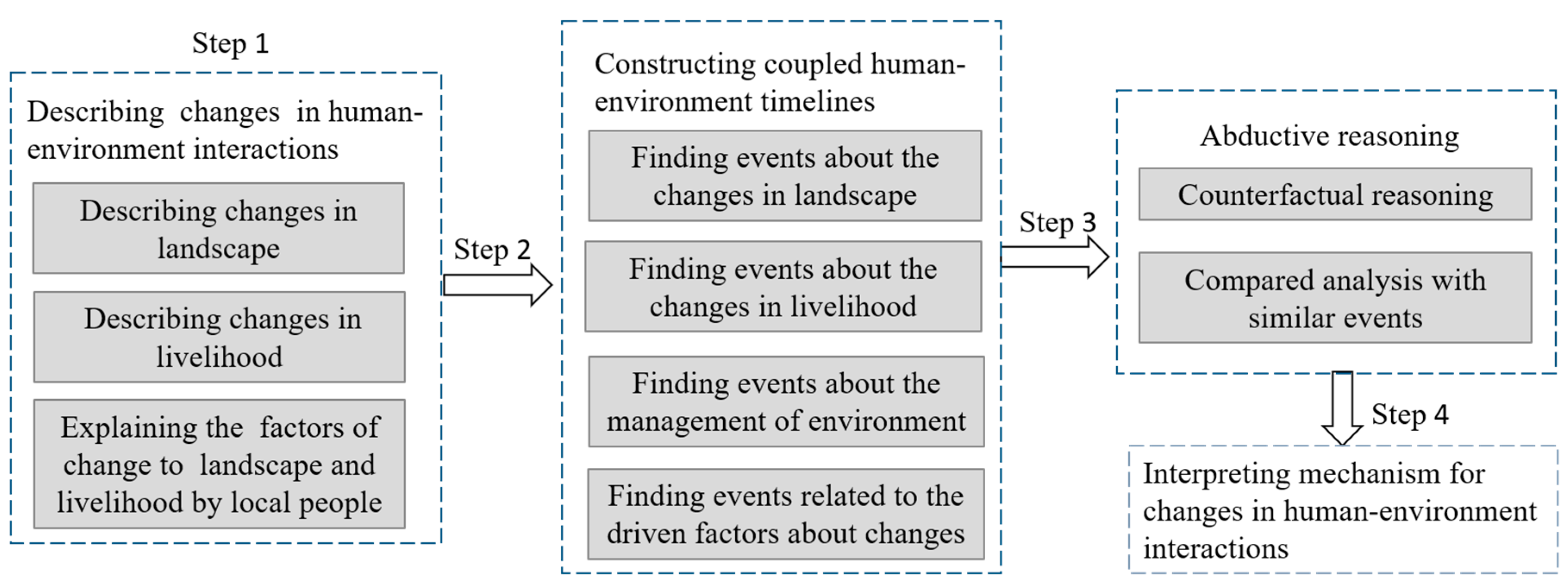
2.2.2. Research Framework

Event ecology proposes to eliminate the constraints on the capabilities of researchers to reason and observe so that researchers may quickly provide an appropriate interpretation of a specific relationship between human-environment interactions with an open mind [34]. However, how to apply the analytical method based on the causal history and abductive reasoning to interpret the changes in human-environment interactions in detail remains unclear. In other words, a clear analytical framework that can be used to describe detailed changes in human-environment interactions, perform a complete analysis of the causal history and explain the rationality of the abductive reasoning is lacking. Thus, we seek to construct a framework for studying human-environment interactions based on event ecology by combining the study of human-environment interactions with the methodology of anthropology topology. The new analytical framework includes the following contents and steps (Figure 1).
First, we describe the detailed changes in human-environment interactions based on the local landscape and livelihood. Human-environment interactions are a complicated, abstract concept that includes a wide range of themes and contents. Given that event ecology requires the events to be practical, observable, and experiential, the indices to describe the changes in human-environment interactions must also be practical and observable. In the framework of human-environment interactions proposed by Buttimer, human-environment interactions include the natural environment, the landscape, and values. The landscape, a dynamic intersurface that connects the natural environment to human values, can temporally and spatially represent the interaction between human activities and the environment. From the temporal perspective, the landscape is a “recorder” that records historical experiences, and it is also a symbol of spiritual values and the complete ecological environment [35]. In addition, Buttimer notes that the means of livelihood connect social organizations and cultural traditions to specific natural environments, and each means of livelihood includes symbolic, functional, and biophysical environmental experiences that are all interactively correlated. The environmental experience on each level embodies a series of spatial and temporal characteristics, which, in turn, are affected by temporal evolution and varying techniques and systems over time [36]. To summarize, the special characteristics of the landscape and the means of livelihood satisfy the requirement of event ecology that events of landscape and livelihood must be studied extensively in time and space. Thus, in the new research framework, we adopt variations in the landscape and the means of livelihood as primary indices to characterize changes in the human-environment interactions.
Second, we analyze the events related to human-environment interactions based completely on causal historical analysis. However, the process lacks a detailed procedure for performing causal historical analysis. Topology is a new direction in anthropology, and its theory and method are generally consistent with event ecology. In general, topological studies involve research that objectively describes regional landscapes. Currently, the topology used by anthropologists is different from that used in traditional anthropology; instead, anthropologists describe topology as a method and comprehensive knowledge that include geography, living, political boundaries, laws, past historical tracers, and regions in a specific space. Topological studies can recover political, legal, economic, or geographic materials with new meanings based on which the landscape and its changing mechanism can be “completely interpreted” [37]. The achievement of “complete interpretation” must originate in a world that includes three aspects of the surrounding world, the interviewees’ discourse and the researcher’s interpreters, which are interactively connected. Specifically, the three aspects of the surrounding world are the landscape and livelihood [38] and the object to be explained in topology. Descriptions and views from residents regarding related events are the interviewees’ discourse, and researchers’ interpreters sufficiently explain the related landscape by participating in the observation and combining the public expressions of residents. Based on the human-environment interactions framework suggested by Buttimer and the “complete interpretation” based on topology, the newly constructed framework for studying human-environment interactions requires describing the changes in the landscape, the means of livelihood and the interpretation of residents of the changes in the landscape and means of livelihood, thus providing interpreters with sufficient information. This is the first step in constructing the research framework (Figure 1).
Third, for topological studies in anthropology, a complete interpretation can only be achieved if it is closely related to temporality. Such time-dependent studies typically require long-term experiences and observations of the historical evolution in a place, which are difficult to achieve for most studies but can be recalled and traced by revisiting [39]. The study by Reenberg and Nielsen presents a good example of the revisiting method, from which they conclude that the changes in human-environment interactions are related to structural limitations, geographic factors, political economy, and biophysical information in addition to the associated historical context. Thus, the trajectory of the changes in human-environment interactions may be interpreted through the temporal and spatial evolutions of the driving factors that caused changes in the landscape and the means of livelihood; in addition, the temporal and spatial evolutions of the driving factors may be studied by establishing a “coupled human-environment timeline” based on the revisiting method [40]. To analyze human-environment interactions based on event ecology, we adopt the “coupled human-environment timeline” to construct the causal history, which is the second step in constructing the research framework (Figure 1).
Finally, changes in human-environment interactions must be explained by abductive reasoning based on causal historical analysis. Walters and Vayda propose that counterfactual reasoning is the most effective method for reducing the causal chain. A detailed example of counterfactual reasoning is that if the existing factor/context does not exist, then does this context remain the same? If the answer is negative, then the corresponding factor is advantageous in explaining the causal relationship. However, the answer for a counterfactual question is typically unclear; thus, comparison with similar events in similar regions is necessary for a definitive conclusion. In summary, abductive reasoning and the final causal interpretation of human-environment interactions are the third and fourth steps, respectively, in constructing the new framework (Figure 1).

3. Study Area and Information Collection
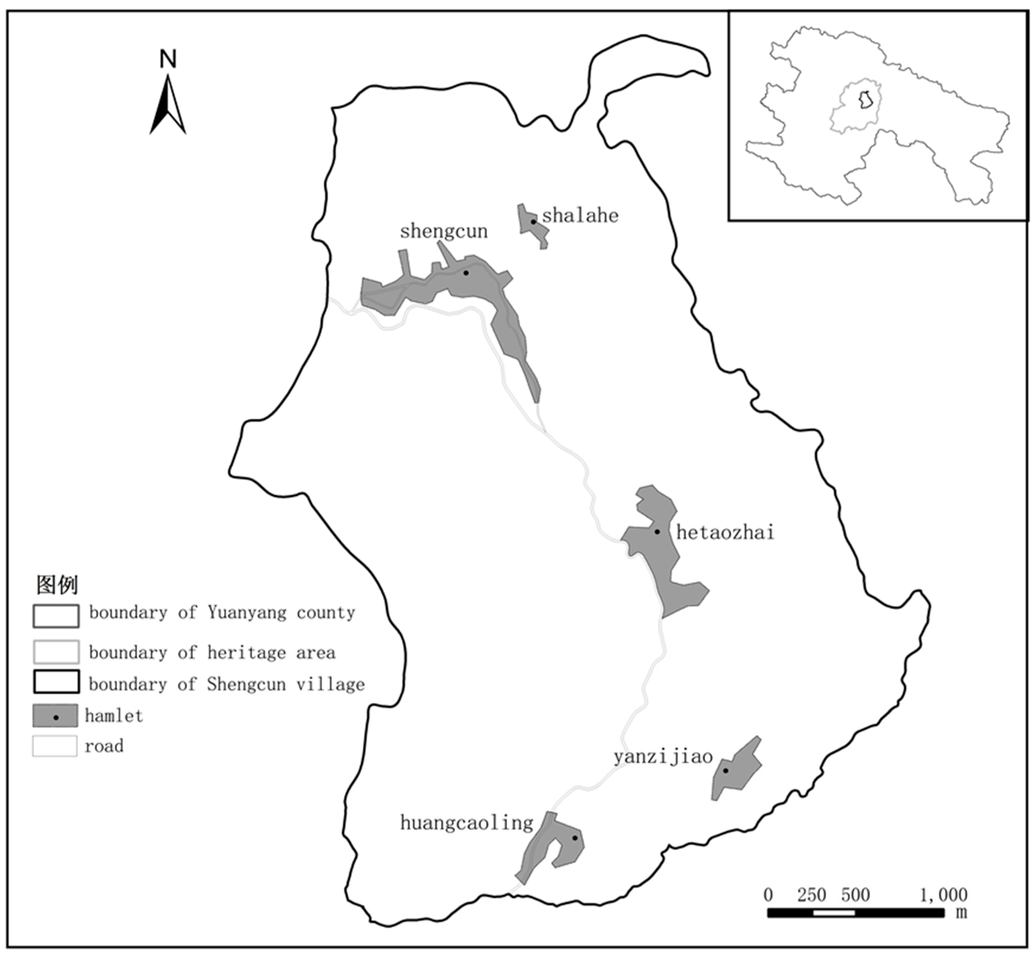
3.1. Study Area

The Honghe Hani Rice Terraces are widely distributed along the southern bank of the Honghe River and the southern piedmont of the Ailao Mountains in southern Yunnan in China, specifically distributed in Yuanyang County, Honghe County, Luchun County and Jinping County. This area has a sub-tropical monsoon climate, and the wet and dry seasons are distinctly different. The rainfall period is between May and October, and the dry season is between November and April. The World Heritage Site of the HHRT is in Yuanyang County (see Figure 2), which has a total area of 46,100 hectares, of which 8866.82 hectares are terraced rice fields. Four rivers pass through the protected area, including the Malizhai, Dawazhe, Geta and Amengkong Rivers. Three areas of terraces, Bada, Duoyishu and Laohuzui, within three river basins, Malizhai, Dawazhe and Amengkong-Geta, are the largest and best protected rice terraces in HHRT. The heritage site includes one town named Xinjie, two townships named Panzhihua and Huangcaoling, 18 villages and 82 hamlets.
The research site, the village committee of Shengcun, is in the town of Xinjie and is an important village in the heritage area. Xinjie includes five hamlets, Shengcun, Shalahe, Hetaozhai, Yanzijiao and Huangcaoling, of which Shengcun and Yanzijiao belong to the Yi minority and the other three villages belong to the Hani minority. The administrative division of the Shengcun committee was Shengcun Township from 1988–2007, which was disbanded in 2007 due to the “township-dismiss and town-combination” policy of the Chinese government; thus, Shengcun Township became an administrative village that was combined with Xinjie Towns, and the original township government moved and merged with the government of Xinjie Towns. The hamlet of Shengcun, approximately 18.6 km from Xinjie Town, is the important administrative center in which the previous township government and the current village committee are located, and it is also an important traditional rural market; thus, the population is more condensed, and the village is more developed than other hamlets. Shengcun hamlet is also well equipped with facilities and departments such as rural credit cooperatives, an industrial and commercial administration bureau, local police stations, high schools, elementary schools, health centers and indemnificatory apartments. Since the Hani Terraces became a world heritage site in 2013, Shengcun has become one of the three tourist service centers in the heritage area providing dining, tourist lodging and family accommodation services, because of its prior historical accumulation and high degree of development. Shengcun hamlet can be spatially divided into two sub-regions: the eastern region is the traditional village, and the western region is where the departments of the original township government were located. In 1991, the government took over residents’ farmland and built a farmers’ market in the western region; later, the government also brought the rural market close to the farmers’ market to accelerate the degree of gathering the population and increasing development in the western region. With the continuous development of heritage tourism in recent years, urbanization driven by tourism has become quite characteristic, and restaurants and hotels continue to increase around the farmers’ market and the rural market. Simultaneously, the situations in which the rice terraces near the western region have become dry lands or people have given up farming have continued to deteriorate. Water for irrigating terrace lands in the western region primarily comes from a gully called Mipumozuo (local language). In the last 10 years, water resources have become insufficient, resulting in a water crisis and multiple conflicts. For instance, in March 2016, farmers cut down water pipes to some of the hotels to irrigate their farmlands in the western region, and fights occurred because local farmers believed that the water use by some of the hotels resulted in reduced water for their terrace irrigation, and they argued that these hotels should not use water from the Mipumozuo gully. This event is the most extreme case of the water crisis in recent years. We focus on the western region of the Shengcun hamlet to analyze changes in human-environment interactions and the corresponding mechanism (Figure 2).

3.2. Information Collection

We collected most of the research data and materials in May and July 2016. To obtain data, we used remote sensing imaging of the land surface, door-to-door private interviews and group interviews. The remote sensing imaging of 2005, 2010 and 2015 were the basic data for analyzing the changes in the terraces landscape. The landscape changes were primarily investigated based on the change from rice terraces to dry lands as well as the change in the building land. In addition, the change in the terraced landscape was also investigated by field investigation to identify the source of the water supply and its corresponding irrigation canals and coverage range via global positioning system (GPS). In addition, with the assistance of a local guide, we identified the corresponding householder of each dried-up terrace. To obtain information about changes in the landscape and the means of livelihood and interpretations of these changes by local residents, we conducted semi-structured interviews with 36 households whose terraces became dry lands in the western region (88% of affected households). During the interviews, participants were asked to describe the changes in the landscape and their means of livelihood in the last 10 years and to preliminarily identify the driving factors. Finally, to construct a local coupled human-environment timeline, we further interviewed three important groups: one group comprising senior males, including 14 people aged 65–87; one group comprising senior females, including eight people aged 68–79; and a final group comprising the village committee leader, village head, forest manager and water manager. The interviews of these three groups sought to obtain in-depth information regarding events related to the ecological environment, socioeconomics, means of livelihood, landscape change and the method of resource distribution to amass more clues regarding the changes in local human-environment interactions.

4. Results

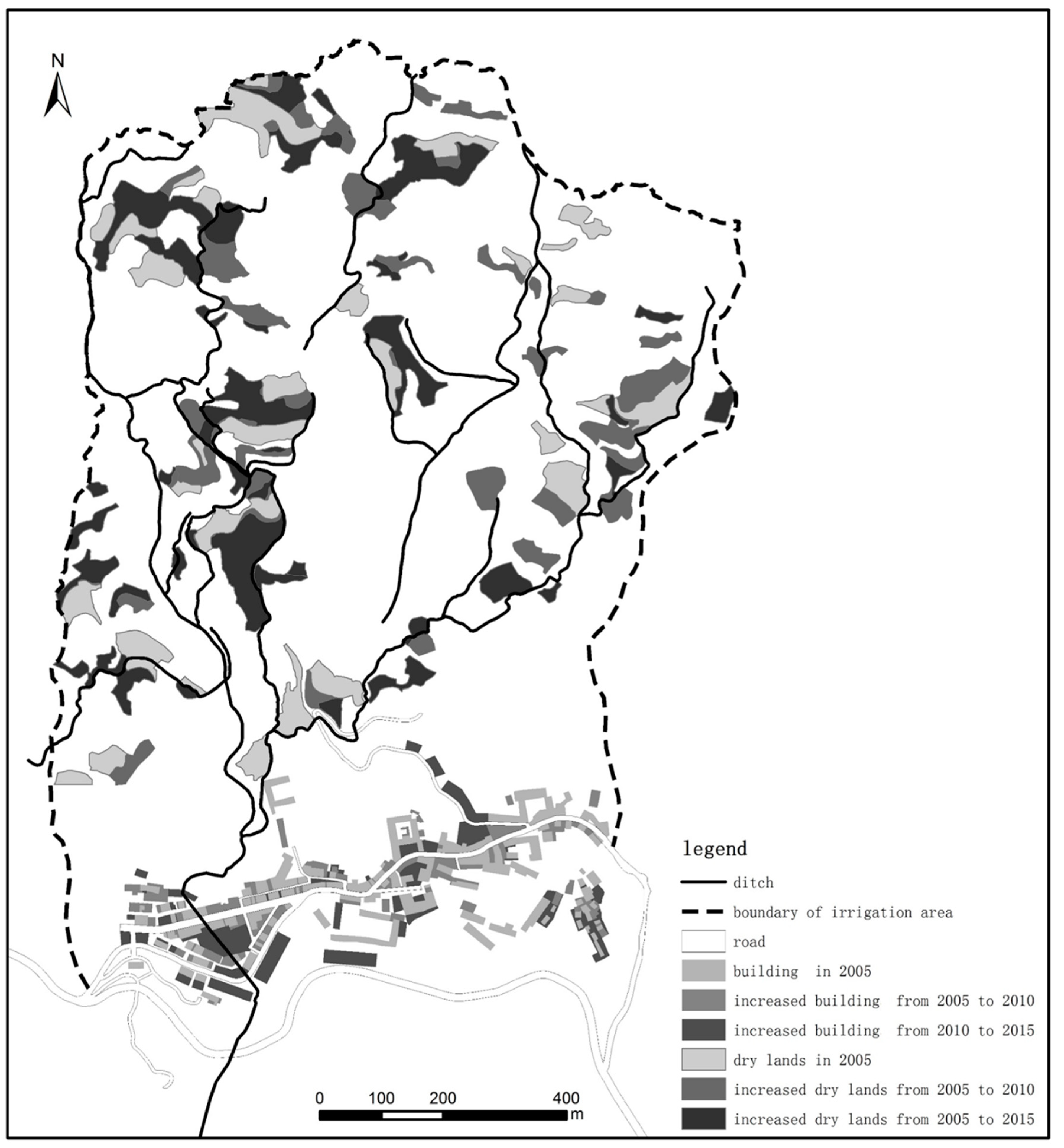
4.1. Changes in Landscape and Means of Livelihood

The most obvious landscape changes were that rice terraces dried up and restaurants and hotels continued to increase with the development of tourism. The remote sensing images during three periods in 2005, 2010 and 2015 processed by the ArcGIS, combined with the field investigation, showed dynamic variations in the dried-up terraces and changes in restaurants and hotels during different periods of time (Figure 3). Figure 3 shows the water source for terrace irrigation in the western region of Sengcun, the Mipumozuo gully, and its irrigation coverage region. The figure clearly shows that from 2005 to 2015, the area of dried-up terraces continued to increase in Shengcun; from 2005 to 2010, 8.6-hectare rice terraces became dry land, and from 2010 to 2015, this number increased to 17.33 hectares. The information gathered from the door-to-door private interviews indicates that the terraces of 20 households been dry lands for 2–5 years, those of 11 households had been dry lands for 5–10 years, and those of only five households had been dry lands for more than 10 years. In addition, the figure shows that the construction area and the building density also continued to increase. From 2005 to 2010, the increased building area was 13,319 m2, and from 2010 to 2015, this number increased to 20,903 m2. According to the field investigation, the types of increased buildings included hotels, family accommodations and restaurants.
In most cases, the means of livelihood in Shengcun is growing corn instead of rice in dried-up terraces, and other farmers also grow cedar and black cardamom. Most households feed pigs with corn and then sell the pigs to buy rice or sell the corn directly to buy rice. Similarly, the growth of cedar and black cardamom by some of the farmers is not for economic purposes but rather for reducing management costs and claiming their rights of land ownership. Because numerous villagers in Shengcun have travelled outside for a living since the 1980s, such wage income became the primary means of livelihood, and only a small percentage of farmers cannot travel for outside work as short-term contractors in nearby villages to help other farmers plant or harvest crops. Consequently, the change in livelihood caused by dried-up terrace lands is not obvious.

4.2. Causes of the Changes in Landscape and Residents’ Means of Livelihood

The water crisis was the direct cause of terraces becoming dry lands. During the semi-structured interviews with 36 household farmers whose terraces became dry lands, 30 householders noted that the water crisis was the main reason for not growing paddies, and six concluded that the dry lands were a result of both water and labor shortages. During the interviews, we asked for the farmers’ assessments of the causes of the water crisis (could be multiple causes), which were sorted based on the frequencies with which they were noted during the interviews (high to low): (1) increased water use caused by increased hotels and restaurants near the farmers’ market in the western region (22 households, 61%); (2) decreased precipitation (12 households, 33%); (3) decreased forest water production caused by growing black cardamom in headwater forests (seven households, 11%); (4) unknown reasons (seven households, 19%); (5) decreased forest water production caused by planting cedar in the county and township forestry center (four households, 11%); (6) decreased forest water storage due to extensive deforestation in the township forestry station (three households, 8%) and (7) the failure of the traditional water distribution system (three households, 6%). The statistical results indicated that the overwhelming opinion of residents was “increased hotels in the western region resulted in increased water use and thus decreased the amount of water for irrigation”.
The residents’ overwhelming opinion was not entirely accurate; some other factors should be considered. The water source for terraces around the western region is the Mipumozuo gully, and its irrigation coverage is shown in Figure 3. The period from January to April of each year is the season with the lowest precipitation, but it is also the season for preparing for transplanting rice seedlings, requiring the greatest amount of water for irrigation. However, it is the hot tourist season; thus, water consumption by tourists also increases. According to the field studies and investigation, 38 hotels with 800 beds are generally fully booked during Spring Festival (generally in February). The amount of tap water supplied by the government cannot satisfy the consumption by these hotels; thus, some of them have constructed pipes to transport water directly from the Mipumozuo gully. During the interviews, we learned that when the government took over land for planning the western region, it took over the farmlands of many residents, which resulted in complaints concerning the compensation provided by the government. In addition, the fact that some of the hotels use water from the gully encroaches on the collective water rights of residents. Thus, villagers paid great attention and are sensitive to the development of the western region. Under the influence of all these factors, villagers drew the conclusion that the increased number of hotels in the western region resulted in increased water use and thus decreased the amount of water for irrigation. To identify the cause of the water crisis from a broader view and objectively digest the causes of the water shortage provided by the villagers, we constructed a coupled human-environment timeline pertaining to the dried-up terraces to examine the timing of relevant events and explore the causal history.

4.3. Causal Historical Analysis for Changes in Landscape and Human-Environment Interaction

We established a “coupled human-environment timeline” related to terraced land becoming arid land. The choice of time nodes for the “coupled human-environment timeline” began in 1980. After 1980, the pattern of social organization in all villages changed from “integration of government administration and commune management” to “separation of government administration from commune management.” The economic system changed from a planned economy to a market economy, coupled with the implementation of the government’s forest tenure reforms, and some policies and effects of natural resource management began to emerge. According to the research framework in Figure 1, to establish the “coupled human-environment timeline,” it was necessary to first sort out the events related to landscape changes, which primarily involved issues related to local tourism and socio-economic development. Second, it was necessary to sort out the events related to livelihood changes, which primarily involved important events in which terrace production was the primary means of livelihood. Third, it was necessary to sort out events related to the management of natural resources, which primarily involved the management of important local resources such as forests and water sources. Finally, it was necessary to sort out the natural factors related to the changes in landscapes, livelihoods, and natural resources management, which primarily involved the important events that governed the changes in the natural environment. After conducting group interviews with the elderly men, elderly women and the group comprising village committee leaders, village heads, forest managers and water managers in Shengcun Village, we learned about the important events in the village over the past 30 years and established the “coupled human-environment timeline” (Figure 4).
From the perspective of tourism development, the appearance of tourists in Shengcun was an important event in local socioeconomic development. Since the 1990s, the Honghe Hani Terraces have become known in the outside world, resulting in tourist visits. During the early period, tourists were quite rare; thus, hotels were also sparse. In 2003, hotels first appeared in Shengcun, and the number of hotels increased rapidly after the Hani Terraces became a world heritage site in 2013. For instance, from 2015 to mid-2016, eight new hotels opened. The eastern region was traditionally the region of villagers, and visitors were not allowed to stay in this region; thus, nearly all the hotels are distributed in the western region of Shengcun.
From the perspective of socioeconomic development, the development of the western region was an important social and economic event. Prior to 1991, there was no farmers’ market in the western region; only the traditional rural market was held in the eastern region. In 1992, the government took over the farmlands of local residents in the western region to build a farmers’ market and moved the traditional rural market to the western region. From 1992 to 1998, lands were circulating between farmers and the government and then between the government and businessmen. After 1998, the number of private stores and hotels continued to increase. In addition, since the Hani Terraces became a world heritage site in 2013, banks, large hotels, and indemnificatory apartments have continuously been built in Shengcun because it is a key tourist service center in the heritage area.
From the perspective of environmental factors, decreased precipitation since 2009 has been a random event in the last 50 years. According to statistics [41], from 1965 to 1995, precipitation was stable in Yuanyang County, and the annual precipitation was approximately 1,400 mm. From 1995 to 2008, precipitation showed large fluctuations with a decreasing trend and only reached 649.6 mm in 2009, the lowest amount in history. The precipitation from 2009 to 2014 was also the lowest in the last 50 years.
From the perspective of forest resources and management, several special events caused by human activities affected the current water storage and water production capabilities of the forests. In 1957, the forest coverage in Yuanyang County was 57% and decreased to 20.8% in 1982 [42] due to the “the nationwide iron and steel production campaign” in 1958 and the “emulating Dazhai on agriculture” in 1972. In 1982, guided by the “three legalizations” and “two mountains” forestry policy, the forest rights were designated, and forests began to be planted, with cedar being the primary species in Yuanyang County. The reforestation continued until 2005. From 2002 to 2005, the “grain for green” project was undertaken. In 2004, the township forestry station began contracting projects for villagers to grow black cardamom (economic crops), with a contract period of 50 years. From 2007–2015, the black cardamom growing area reached its maximum, nearly 40 hectares. Between 2007 and 2010, the swamps nearly completely disappeared in the forests, leaving no water behind. In 2010, extensive deforestation began in the township forestry station, and the deforested area reached 45.59 hectare. Except for areas near the gullies due to geographic barriers, the forests in other areas were completely deforested in the township forestry station; the current forests are generally cedar seedlings that were transplanted after the deforestation.
From the perspective of water resource management, after the people’s commune and cooperative were founded, the traditional management system for water resources was weakened. Under the traditional management system, “woodcut water-distribution” was implemented, which means that each water source corresponded to a terrace land for irrigation and could not be used for other terrace lands. The distribution of the amounts of water was determined by consultation. Once it was determined, the amount of water was strictly distributed according to the corresponding sizes of the water channels, which were managed by a channel supervisor. After the people’s commune (1958–1966) and cooperative (1967–1984), water continued to be distributed according to the “woodcut water-distribution” policy, although there was no longer an assigned channel supervisor. After the cooperative, the “woodcut water-distribution” policy was abandoned. From 2005 to 2015, because there was no assigned channel supervisor, the water channels lacked proper maintenance, and some of them were damaged. Consequently, people fought for water because of the water crisis. After 2009, water nearly disappeared in some of the water channels.
Thus, the dried-up terrace lands are the result of the cross effects of the multiple events listed above, which also show a certain variation trend. In 1995, terraces began to become dry lands, and the change rate continued to increase from 2005–2010, peaking between 2010 and 2015. Accordingly, we conducted abductive reasoning to explain the cause of the water crisis based on the historical processes discussed above and the perspectives of local residents.

4.4. Abductive Reasoning and the Results

Land circulation during the construction of the farmers’ market and the proliferation of hotels and restaurants driven by tourism in this region were the superficial causes of the water crisis for terrace irrigation. To build the farmers’ market, farmlands were taken over, and subsequently, some of the lands were returned to farmers for building houses as compensation. In 1998, the remaining lands belonged to the government, which had the right to freely trade the lands. However, farmers in good financial condition and farmers from other villages bought lands to build houses, some of which later became hotels with the development of tourism. Thus, the time when the terraces were rapidly drying up coincided with the rapid development of hotels. However, according to our field investigation, only six hotels were supplied with water from the gully whereas water for other hotels and enterprises primarily came from nearby reservoirs. In addition, hotels are fully booked mainly during the Spring Festival holiday each year and predominantly vacant from March to May. Because the period from March to May is the time for irrigating the terraces and transplanting seedlings, we concluded that the increase in hotels was not the direct driving force for the terrace water crisis as local residents believed.
From “the coupled human-environment timeline,” the time when terraces began to become dry lands clearly corresponds to the times when precipitation began to fluctuate and decrease and when precipitation severely decreased. Additionally, according to our investigation of other villages at the same sea altitude, we determined that since 2000, all villages have been facing the same context in which decreased water resources resulted in some untillable farmlands. Thus, we conclude that decreased precipitation is an important natural driving force resulting in the terrace water crisis.
Planting black cardamom in forests and deforestation also resulted in reduced forest water storage and therefore were an internal driving force of the water shortage for terrace irrigation. First, Figure 4 shows that the time of planting black cardamom coincided with the period when terraces were rapidly changing into dry lands. According to local villagers, the production of black cardamom is relatively high in cool and humid areas of the forests. Thus, many low-lying swamps in the forests were drained to grow black cardamom, resulting in the disappearance of swamps and a reduced capability of forest water storage. Because of the lack of definitive biophysical information on the effect of growing black cardamom on forest water storage capability, it is difficult to directly determine the resultant effects of planting black cardamom. However, when we applied the counterfactual reasoning and asked the villagers if the water in the forests would increase if they did not grow black cardamom, we received positive answers from some of the villagers whereas others were less certain. In nearby villages with similar situations, some villages dug out the growing black cardamom approximately 3 to 4 years ago due to reduced forest water production, which indicates that it is generally believed that growing black cardamom results in decreased forest water production capability. Furthermore, since the township government moved out in 2007, the township forestry station was fully deforested in 2011 (45.59 ha involved); however, the forests are in fact important for conserving water for the water source, the “Mipumozuo” gully. In theory, deforestation typically results in decreased forest water production capability. Finally, local residents noted that the cedars planted by the government’s forestry station resulted in decreased forest water production because cedars cannot compete with the local tree species in water production and storage. This interpretation seems reasonable but does not hold true according to the timeline. Prior to growing cedar and the “grain for green” project, the forest coverage rate was extremely low. Although cedar may not be not as good as the local species at producing water, cedars nevertheless rapidly increased the forest coverage. Thus, based on the timeline, it is not true that growing cedars resulted in the decreased water production of the forests.
The abandoned traditional water-distribution system did not cause the water crisis for terrace irrigation. Although it was only after the demise of the “woodcut water-distribution” system that terraces began to become dry lands and people started to fight for water, terrace degradation cannot be directly attributed to the demise of the traditional water-distribution system. First, in the timeline, the demise of the “woodcut water-distribution” system does not correspond to the degradation of the terraces. Furthermore, in addition to the additional water resources distributed to tourists and businesses, the terrace water crisis resulted primarily from the reduced water production by the forests caused by variations in the natural environment and human activities. The traditional consultation-based water-distribution system did not involve any of these actors. Thus, even if the traditional water-distribution system still existed, it would not be able to handle this situation. Please note that we do not deny the importance of the traditional water-distribution system; however, a water-distribution system created based on the traditional system will play a key role in the future.
In summary, although it is overwhelmingly thought that the sharp increase in the number of restaurants and hotels resulted in increased water usage and, consequently, a decreased amount of water for irrigation, in fact, the dry local terraces were primarily caused by continuously decreasing precipitation, the planting of water-consuming crops in forests and deforestation in recent years. These factors were not objectively considered mainly because the unbalanced opportunities for residents to participate in tourism were the focus of conflicts in the local community. Thus, the locals exaggerated the contribution of tourism to the dry terraces because they wanted these conflicts to involve outsiders.

5. Discussion and Conclusions

The framework for studying human-environment interactions based on event ecology responded to the emphasis on the role of special events and historical contingency in the interpretation mechanism of changes in human-environment interactions. The framework seeks to address the conflicts between empiricism and positivism for human-environment research to “face the facts” and focus on practical and urgent problems, improving the efficiency of interpretation. In event ecology, different types of evidence must be combined according to the causal historical analysis so that this evidence does not originate from a preexisting common theory to produce corresponding conclusions that are typically viewed as irrational empiricism. In fact, in abductive reasoning, deleting causes requires more prior knowledge than interpreting results based on rules and certain theoretical guidelines. Thus, the framework constructed in this study is an effective method of combining empiricism and positivism to clearly understand the underlying mechanism that affects human-environment interactions. Walters and Vayda applied the analytical method in event ecology to study the actions of forestation and deforestation in St. Lucia and their causes; they questioned the common assumption that property determined the use of resources and environmental production, and they also noted that in addition to property, other factors also affected forestation and deforestation, including the regional topography [43], the varying business market, the labor market, immigration policy and world trading behavior [44]. The case studies further demonstrated the effectiveness of event ecology in explaining the interaction between human activities and environmental changes in complicated contexts.
The framework for studying human-environment interactions based on event ecology is an effective methodology and can also provide guidance to reveal the mechanisms that cause changes in human-environment interactions. Globally, most protected areas are also tourist destinations, and current studies generally conclude that tourism development results in resource damage, landscape degradation and changes in the means of livelihood in protected areas [45,46]. However, this study shows that such a perspective is incomplete [47]. The tortuous process of protecting the Ifugao Terraces in the Philippines reminds us that when studying the changes in landscape and the changes in human-environment interactions in protected areas, in addition to tourism, we must analyze the changes from a broad perspective by considering the natural, social, and economic contexts and paying attention to the effects of historical contingency on human-environment interactions. Our study of the changes in human-environment interactions in the Honghe Hani Rice Terraces based on this research framework demonstrates that the increased number of hotels as a result of tourism development are only a superficial cause and that, instead, decreased precipitation, the growth of economic crops in the forests and deforestation were the primary driving forces that resulted in terrace degradation and changes in human-environment interactions, which contradicts the consensus reached by local residents. This contradiction illustrates that in the research framework, the “coupled human-environment timeline” was effective in overcoming the limitation of the traditional method so that some of the important factors will not be ignored and other superficial but widely accepted factors will not dominate, resulting in a complete interpretation of the mechanism. In addition, the primary reason local residents attributed the dried-up terraces to tourism is that they did not receive equal opportunities and benefits in the process of heritage development and were therefore willing to link the problem to tourism to obtain additional rights. Thus, we must consider the detailed politics and social background to analyze the mechanism that causes changes in world heritage sites to determine the questions that must be asked in the future to achieve sustainable development of the heritage sites. These are the questions that must be taken seriously for world heritage development and protection.
According to the development history of human-environment interaction research, event ecology was developed based on a critique of political ecology [48]. Event ecology suggests that focusing on the effects of politics on the ecosystem and environmental change is extremely important. However, Vayda and Walters argue that it is problematic to assume that the broad political and economic system is more important than other factors, which simplifies the complexity of a problem and thus misses other factors in varying contexts. Thus, empiricism should be used as guidance, and multiple possibilities must be explored to explain a problem [49,50]. Presupposition and presumption, however, cannot be completely avoided because of the different knowledge backgrounds and experiences of researchers and different research subjects, which affect the types of events observed, the questions asked, and the final conclusions drawn. Robbins notes that it is advantageous to explain human-environment interactions from a broad contextualization to identify diverse causes; however, to understand the relationships among diverse causes, the problem must be investigated in an even broader structure [51]. Further investigations are required to explore how to combine structural forces with the effect of specific local events on human-environment interactions to further improve the research framework proposed in this study.

Author Contributions

S.Z. provided the epistemology framework of this project. H.H. performed the field survey, analyzed the fieldwork information, and wrote major parts of this article. Z.D. performed the field survey and created the figures; Y.P. contributed to the conceptual framework of the methodology.

Funding

This research received no external funding.

Acknowledgments

This research was supported by the Projects of NSFC (No. 41771148 and No. 41671148), the Project of the Humanities & Social Sciences of the Ministry of Education (No. 13YJCZH053) and the Project of. geopolitical environment of Southwest China and frontier development synergy innovation center.

Conflicts of Interest

The authors declare no conflicts of interest.

References

  1. Harden, C.P. Framing and Reframing Questions of Human–environment Interactions. Ann. Assoc. Am. Geogr. 2012, 102, 737–747. [Google Scholar] [CrossRef]
  2. Moran, E.F.; Lopez, M.C. Future Directions in Human-environment Research. Environ. Res. 2016, 144, 1–7. [Google Scholar] [CrossRef] [PubMed]
  3. Young, O.R.; Lambin, E.F.; Alcock, F.; Haberl, H.; Karlsson, S.I.; McConnell, W.J.; Myint, T.; Pahl-Wostl, C.; Polsky, C.; Ramakrishnan, P.S. A Portfolio Approach to Analyzing Complex Human-environment Interactions: Institutions and Land Change. Ecol. Soc. 2006, 2, 31. Available online: http://www.ecologyandsociety.org/vol11/iss2/art31/ (accessed on 3 May 2017). [CrossRef]
  4. Judkins, G.; Smith, M.; Keys, E. Determinism Within Human-environment Research and the Rediscovery of Environmental Causation. Geogr. J. 2008, 174, 17–29. [Google Scholar] [CrossRef]
  5. Vayda, A.P. Progressive Contextualization: Methods for Research in Human Ecology. Hum. Ecol. 1983, 11, 265–281. [Google Scholar] [CrossRef]
  6. Walters, B.B.; Vayda, A.P. Event Ecology, Causal Historical Analysis, and Human-environment Research. Ann. Assoc. Am. Geogr. 2009, 99, 534–553. [Google Scholar] [CrossRef]
  7. Epstein, G.; Vogt, J.; Mincey, S.; Cox, M.; Fischer, B. Missing Ecology: Integrating Ecological Perspectives with the Social-ecological System Framework. Int. J. Commons 2013, 7, 432–453. [Google Scholar] [CrossRef]
  8. Vogt, J.M.; Epstein, G.B.; Mincey, S.K.; Burnell, C.; McCord, P. Putting the “E” in SES: Unpacking the Ecology in the Ostrom Social-ecological System Framework. Ecol. Soc. 2015, 20, 55. [Google Scholar] [CrossRef]
  9. Buttimer, A. Diverse Perspectives on Society and Environment—Plenary Lecture at the 32th International Geographical Congress. Prog. Geogr. 2013, 32, 323–340. [Google Scholar]
  10. Buttimer, A. Geography and the Human Spirit; Johns Hopkins University Press: Baltimore, MA, USA, 1993; pp. 11–35. ISBN 0-8018-4338-3. [Google Scholar]
  11. Aplin, G. World Heritage Cultural Landscapes. Int. J. Herit. Stud. 2007, 13, 427–446. [Google Scholar] [CrossRef]
  12. Akagawa, N.; Sirisrisak, T. Cultural Landscapes in Asia and the Pacific: Implications of the World Heritage Convention. Int. J. Herit. Stud. 2008, 14, 176–191. [Google Scholar] [CrossRef]
  13. Mananghaya, J.B. Heritage, Driver for Development and the Case of the Rice Terraces of the Philippine cordilleras. In Proceedings of the ICOMOS 17th General Assembly, Paris, France, 27 November–2 December 2011. [Google Scholar]
  14. Calderon, M.M.; Dizon, J.T.; Bantayan, N.C.; Sajise, A.J.U.; Codilan, A.L.; Salvador, M.G. Payments for Environmental and Cultural Services and the Conservation of the Ifugao Rice Terraces. Available online: https://www.researchgate.net/publication/265198476 (accessed on 2 June 2017).
  15. Bantayan, N.C.; Calderon, M.M.; Dizon, J.T. Estimating the Extent and Damage of the UNESCO World Heritage Sites of the Ifugao. J. Environ. Sci. Manag. 2012, 15, 459–481. [Google Scholar]
  16. UNESCO. Cultural Landscapes: The Challenges of Conservation. 2002. Available online: http://whc.unesco.org/venice2002 (accessed on 30 May 2015).
  17. Guimbatan, R.; Baguilat, T. Misunderstanding the Notion of Conservation in the Philippine Rice Terraces–Cultural Landscapes. Int. Soc. Sci. J. 2006, 58, 59–67. [Google Scholar] [CrossRef]
  18. Jiao, Y.; Li, X.; Liang, L.; Takeuchi, K.; Okuro, T.; Zhang, D.; Sun, L. Indigenous Ecological Knowledge and Natural Resource Management in the Cultural Landscape of China’s Hani Terraces. Ecol. Res. 2012, 27, 247–263. [Google Scholar] [CrossRef]
  19. Yuan, Z.; Lun, F.; He, L.; Cao, Z.; Min, Q.; Bai, Y.; Liu, M.C.; Cheng, S.K.; Li, W.H.; Fuller, A.M. Exploring the State of Retention of Traditional Ecological Knowledge in a Hani Rice Terrace Village, Southwest China. Sustainability 2014, 6, 4497–4513. [Google Scholar] [CrossRef]
  20. Walters, B.B. Human Ecological Questions for Tropical Restoration: Experiences from Planting Native Upland Trees and Mangroves in the Philippines. Forest Ecol. Manag. 1997, 99, 275–290. [Google Scholar] [CrossRef]
  21. Walters, B.B. People and mangroves in the Philippines: Fifty years of coastal environmental change. Environ. Conserv. 2003, 30, 293–303. [Google Scholar] [CrossRef]
  22. Walters, B.B. Ecological Effects of Small-scale Cutting of Philippine Mangrove Forests. Forest Ecol. Manag. 2005, 206, 331–348. [Google Scholar] [CrossRef]
  23. Walters, B.B. Local Management of Mangrove Forests in the Philippines: Successful Conservation or Efficient Resource Exploitation? Hum. Ecol. 2004, 32, 177–195. [Google Scholar] [CrossRef] [Green Version]
  24. Walters, B.B. Local Mangrove Planting in the Philippines: Are Fisherfolk and Fishpond Owners Effective Restorationists? Restor. Ecol. 2000, 8, 237–246. [Google Scholar] [CrossRef]
  25. Walters, B.B. An Event-based Methodology for Climate Change and Human-environment Research. Geogr. Tidsskr.-Dan. J. Geogr. 2012, 112, 135–143. [Google Scholar] [CrossRef]
  26. Vayda, A.P. Causal Explanation of Indonesian Forest Fires: Concepts, Applications, and Research Priorities. Hum. Ecol. 2006, 34, 615–635. [Google Scholar] [CrossRef]
  27. Walters, B.B. Events, Politics and Environmental Change. In Against the Grain: The Vayda Tradition in HumanEecology and Ecological Anthropology; Walters, B.B., Mc-Cay, B.J., West, P., Lees, S., Eds.; AltaMira Press: Lanham, MD, USA, 2008; pp. 67–79. ISBN 978-0-759-11172-1. [Google Scholar]
  28. Vayda, A.P. Causal Explanation as a Research Goal: A Pragmatic View. In Against the Grain: The Vayda Tradition in HumanEecology and Ecological Anthropology; Walters, B.B., Mc-Cay, B.J., West, P., Lees, S., Eds.; AltaMira Press: Lanham, MD, USA, 2008; pp. 317–367. ISBN 978-0-759-11172-1. [Google Scholar]
  29. Vayda, A.P.; Walters, B.B. Introduction: Pragmatic methods and causal-history explanations. In Causal Explanation for Social Scientists: A Reader; Vayda, A.P., Walters, B.B., Eds.; AltaMira Press: Lanham, MD, USA, 2011; pp. 1–21. ISBN 978-0-7591-1325-1. [Google Scholar]
  30. Walters, B.B. Migration, Land Use and Forest Change in St. Lucia, West Indies. Land Use Policy 2016, 51, 290–300. [Google Scholar] [CrossRef]
  31. Nielsen, J.Ø.; Reenberg, A. Temporality and the Problem with Singling Out Climate as a Current Driver of Change in a Small West African Village. J. Arid. Environ. 2010, 74, 464–474. [Google Scholar] [CrossRef]
  32. Vayda, A.P. Causal Explanation as a Research Goal: Dos and Don’ts. In Explaining Human Actions and Environment Changes; Vayda, A.P., Ed.; AltaMira Press: Lanham, MD, USA, 2009; pp. 1–47. ISBN 978-0-7591-0323-8. [Google Scholar]
  33. Minteer, B.A.; Corley, E.A.; Manning, R.E. Environmental Ethics Beyond Principle? The Case for a Pragmatic Contextualism. J. Agric. Environ. Ethics 2004, 17, 131–156. [Google Scholar] [CrossRef]
  34. Robbins, P.; Vayda, A.P.; Walters, B.B. (Eds.) Causal Explanation for Social Scientists. Hum. Ecol. 2012, 40, 657–659. [Google Scholar]
  35. Buttimer, A. Sustainable Development: Issues of Scale and Appropriateness. In Sustainable Landscapes and Lifeways: Scales and Appropriateness, 1st ed.; Buttimer, A., Ed.; Cork University Press: Cork, Ireland, 2001; pp. 24–28. ISBN 3-0623-1310-5. [Google Scholar]
  36. Buttimer, A. Landscape and Life: Appropriate Scales for Sustainable Development. Irish Geogr. 1998, 31, 1–33. [Google Scholar] [CrossRef]
  37. Zhu, X.Y. Black Land, Sick Land and Lost Land: The Topography of a Yunnan Village and a Critique of Scott. J. China Agric. Univ. 2008, 25, 22–48. [Google Scholar]
  38. Zhu, X.Y. The Forestry Tenure and the Topography: A Case Study of a Yunnan Village. J. China Agric. Univ. 2009, 26, 60–72. [Google Scholar]
  39. Zhu, X.Y. The Story of a Yunnan Village: Topography and Home; Peking University Press: Beijing, China, 2011; pp. 54–70. ISBN 978-7-301-18196-6. [Google Scholar]
  40. Reenberg, A.; Birch-Thomsen, T.; Mertz, O.; Fog, B.; Christiansen, S. Adaptation of Human Coping Strategies in a Small Island Society in the SW Pacific—50 Years of Change in the Coupled human–environment System on Bellona, Solomon Islands. Hum. Ecol. 2008, 36, 807–819. [Google Scholar] [CrossRef]
  41. The Bureau of Honghe Prefecture Statistics. Statistical Yearbook of Honghe Autonomous Prefecture; Yunnan Science and Technology Publishing Press: Kunming, China, 2015; pp. 15–60. ISBN 978-7-541-64191-6. [Google Scholar]
  42. Wang, Q.H. On the Culture of the Terraced Field; Yunnan University Press: Kunming, China, 2003; pp. 53–81. ISBN 7-81025-917-2/G·125. [Google Scholar]
  43. Walters, B.B.; Hansen, L. Farmed Landscapes, Trees and Forest Conservation in Saint Lucia (West Indies). Environ. Conserv. 2013, 40, 211–221. [Google Scholar] [CrossRef]
  44. Walters, B.B. Do Property Rights Matter for Conservation? Family Land, Forests and Trees in Saint Lucia, West Indies. Hum. Ecol. 2012, 40, 863–878. [Google Scholar] [CrossRef]
  45. Williams, P.W.; Ponsford, I.F. Confronting Tourism’s Environmental Paradox: Transitioning for Sustainable Tourism. Futures 2009, 41, 396–404. [Google Scholar] [CrossRef]
  46. Nyaupane, G.P.; Poudel, S. Linkages among Biodiversity, Livelihood, and Tourism. Anna Tour. Res. 2011, 38, 1344–1366. [Google Scholar] [CrossRef]
  47. Mbaiwa, J.E. Changes on Traditional Livelihood Activities and Lifestyles Caused by Tourism Development in the Okavango Delta, Botswana. Tour. Manag. 2011, 32, 1050–1060. [Google Scholar] [CrossRef]
  48. Smith, D.M. Explaining Human Actions and Environmental Changes. J. Ecol. Anthropol. 2010, 14, 101–102. [Google Scholar] [CrossRef] [Green Version]
  49. Vayda, A.P.; Walters, B.B. against Political Ecology. Hum. Ecol. 1999, 27, 167–179. [Google Scholar] [CrossRef]
  50. Walters, B.B. Explaining Rural Land Use Change and Reforestation: A Causal-Historical Approach. Land Use Policy 2017, 67, 608–624. [Google Scholar] [CrossRef]
  51. Robbins, P. Political Ecology: A Critical Introduction, 2nd ed.; John Wiley & Sons: Chichester, UK, 2011; pp. 46–48. ISBN 978-0-470-65732-4. [Google Scholar]
Figure 1. A framework for studying human-environment interactions based on event ecology.
Sustainability 10 02230 g001
Figure 2. Location of study area.
Sustainability 10 02230 g002
Figure 3. Changes of landscape in the western region of Shengcun hamlet.
Sustainability 10 02230 g003
Figure 4. A coupled human-environment timeline from 1980–2015 in Shengcun hamlet.
Sustainability 10 02230 g004

