Fine-Scale Evaluation of Giant Panda Habitats and Countermeasures against the Future Impacts of Climate Change and Human Disturbance (2015–2050): A Case Study in Ya’an, China


Abstract
:1. Introduction
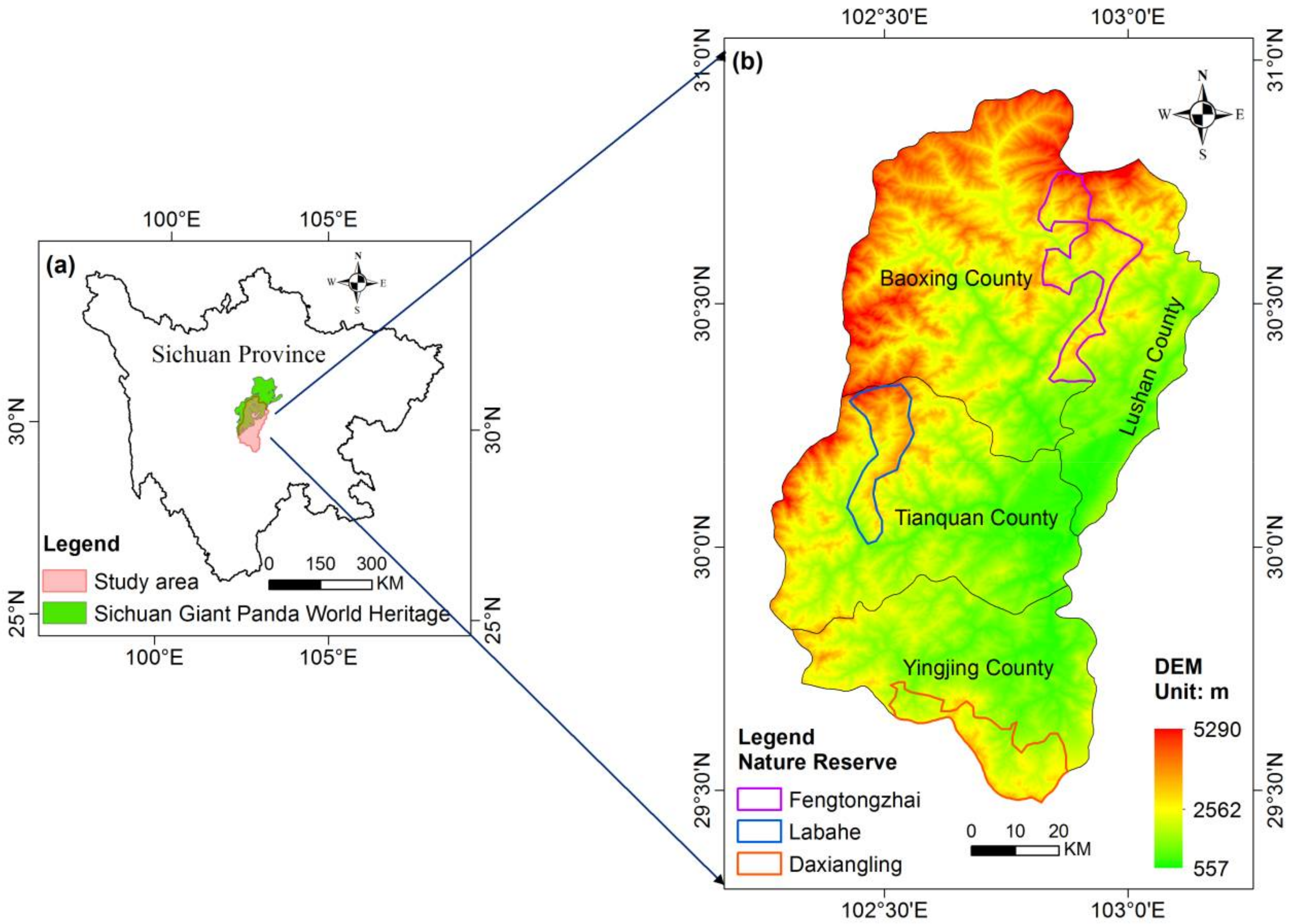
2. Study Area
3. Materials and Methods
3.1. Data Sources
3.1.1. Physical Environmental Data
3.1.2. Biological Factor Data
3.1.3. Human Disturbance Data
3.1.4. Bioclimatic Data
3.1.5. Remote-Sensing Data
3.1.6. Ground Investigation Data
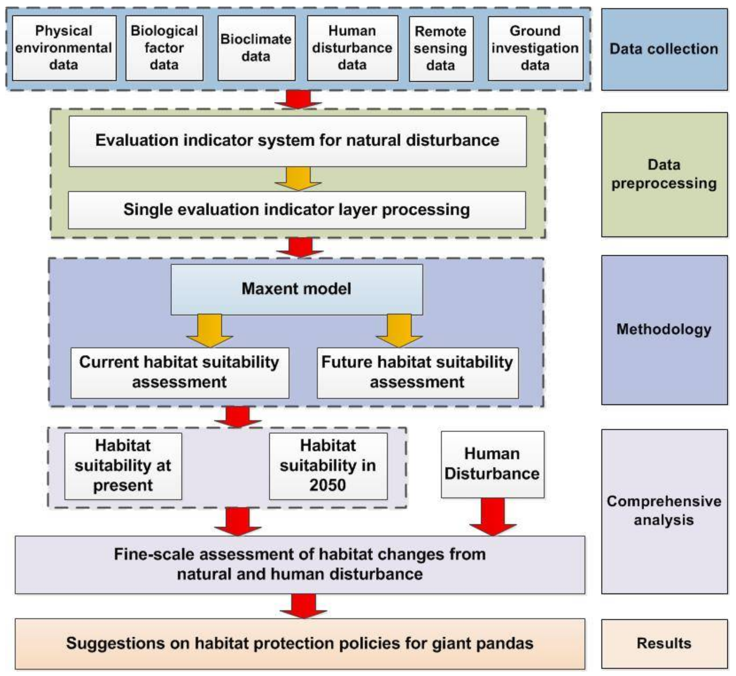
3.2. Research Method
4. Results and Discussion
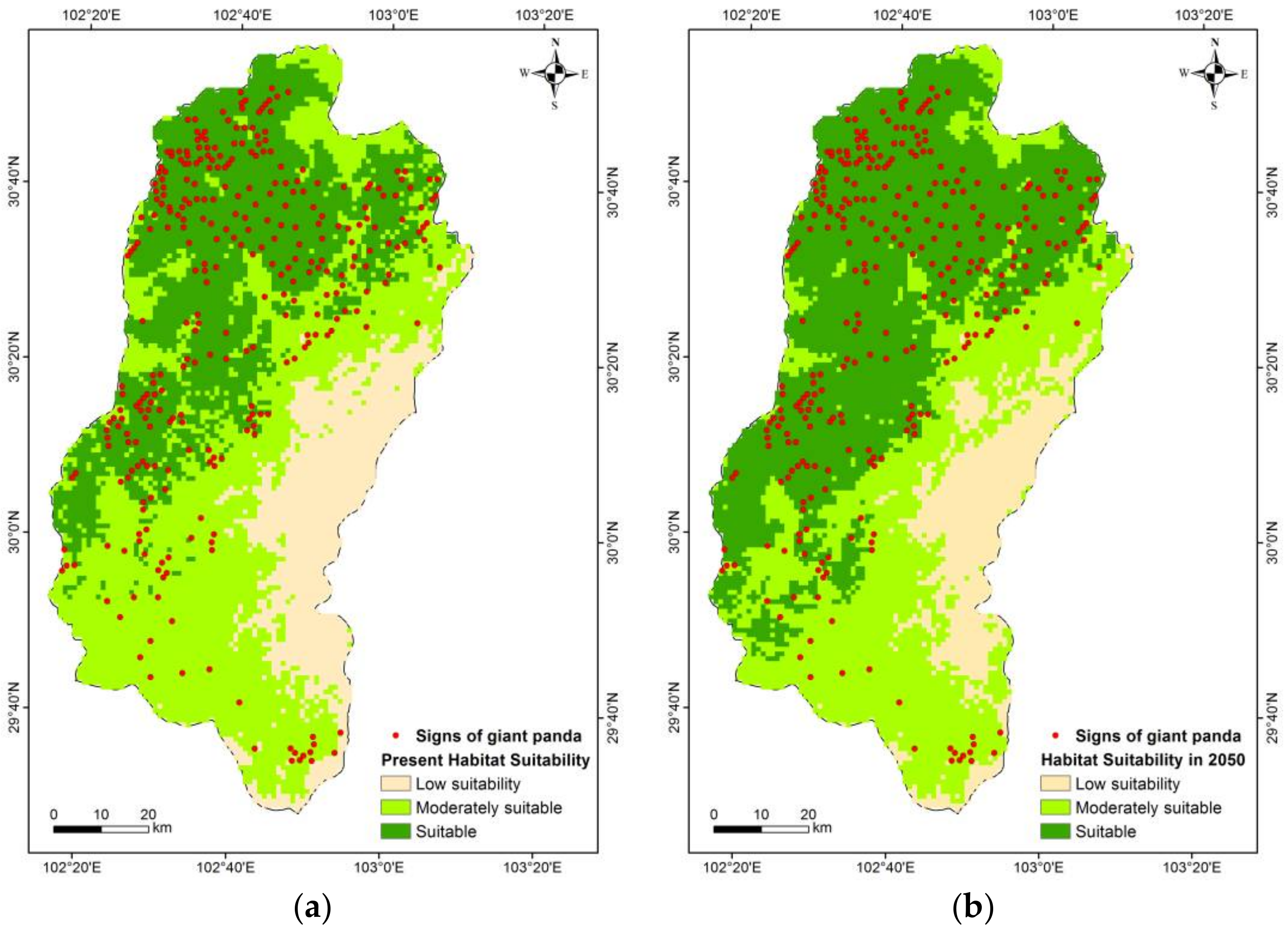
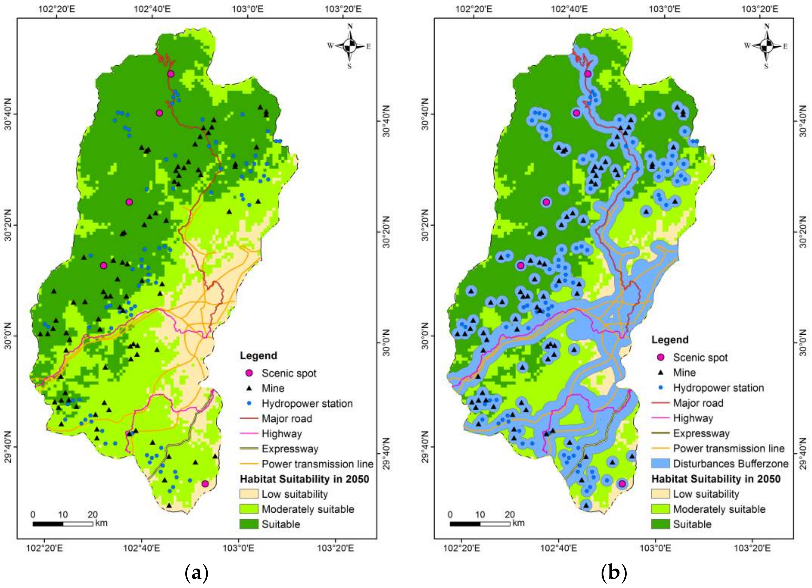
4.1. Habitat Suitability under Climate Change
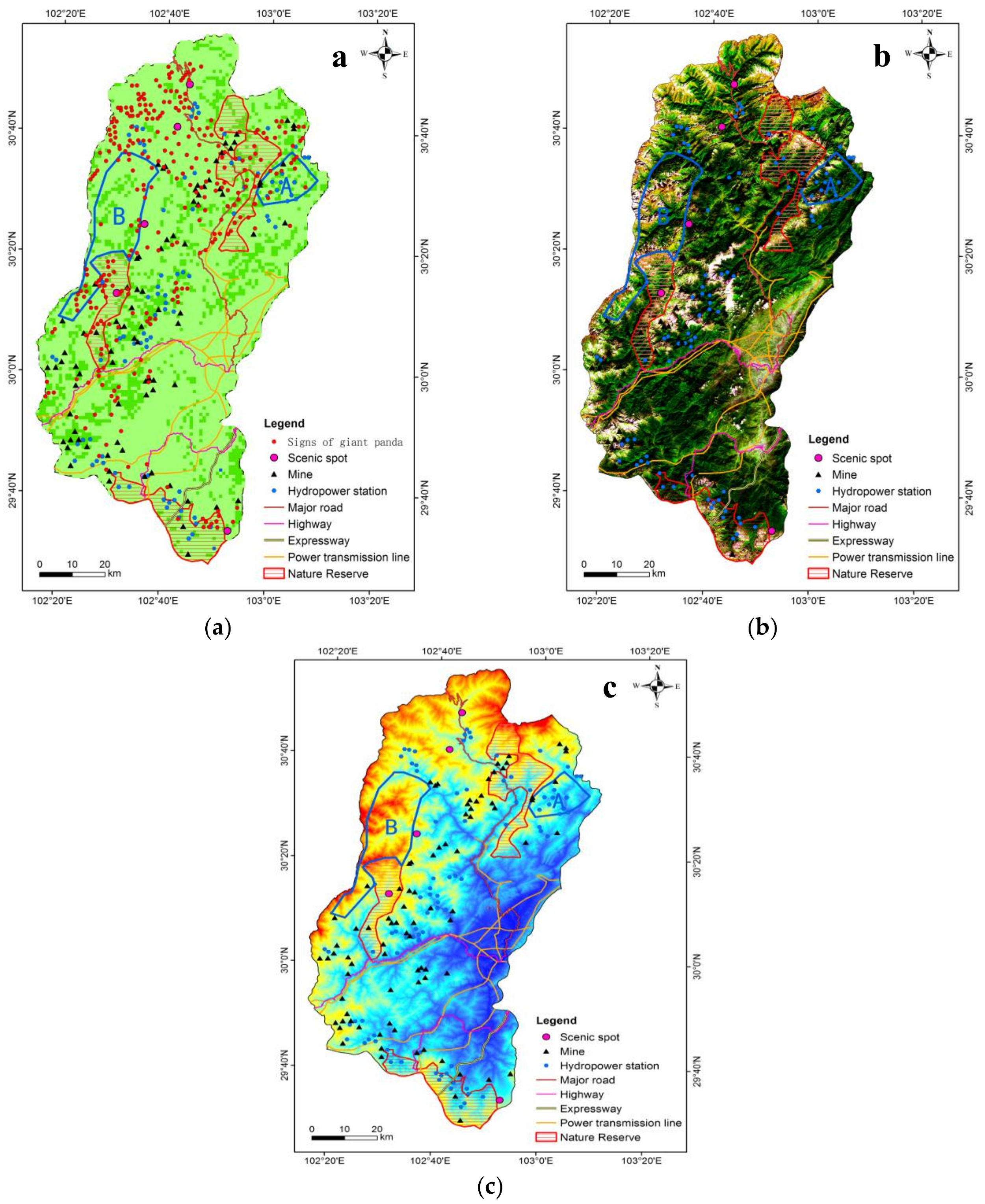
4.2. Habitat Suitability Changes under Combined Climate Change and Human Disturbance
4.3. Discussion
4.4. Suggestion
5. Conclusions
Acknowledgments
Author Contributions
Conflicts of Interest
References
- Intergovernmental Panel on Climate Change (IPCC). Climate Change 2014: Synthesis Report; IPCC: Geneva, Switzerland, 2014. [Google Scholar]
- Fan, J.; Li, J.; Xia, R.; Hu, L.; Wu, X.; Li, G. Assessing the impact of climate change on the habitat distribution of the giant panda in the qinling mountains of China. Ecol. Model. 2014, 274, 12–20. [Google Scholar] [CrossRef]
- Qin, A.; Liu, B.; Guo, Q.; Bussmann, R.W.; Ma, F.; Jian, Z.; Xu, G.; Pei, S. Maxent modeling for predicting impacts of climate change on the potential distribution of thuja sutchuenensis franch, an extremely endangered conifer from southwestern China. Glob. Ecol. Conserv. 2017, 10, 139–146. [Google Scholar] [CrossRef]
- Parmesan, C.; Yohe, G. A globally coherent fingerprint of climate change impacts across natural systems. Nature 2003, 421, 37–42. [Google Scholar] [CrossRef] [PubMed]
- Compilation Committee of the third national assessment report on climate change. The Third National Assessment Report on Climate Change; Science Press: Beijing, China, 2015. (In Chinese) [Google Scholar]
- Root, T.L.; Price, J.T.; Hall, K.R.; Schneider, S.H.; Rosenzweig, C.; Pounds, J.A. Fingerprints of global warming on wild animals and plants. Nature 2003, 421, 57–60. [Google Scholar] [CrossRef] [PubMed]
- Li, R.Q.; Xu, M.; Wong, M.H.G.; Qiu, S.; Li, X.H.; Ehrenfeld, D.; Li, D.M. Climate change threatens giant panda protection in the 21st century. Biol. Conserv. 2015, 182, 93–101. [Google Scholar] [CrossRef]
- Urban, M.C. Accelerating extinction risk from climate change. Science 2015, 348, 571–573. [Google Scholar] [CrossRef] [PubMed]
- Xu, W.; Viña, A.; Kong, L.; Pimm, S.L.; Zhang, J.; Yang, W.; Xiao, Y.; Zhang, L.; Chen, X.; Liu, J. Reassessing the conservation status of the giant panda using remote sensing. Nat. Ecol. Evol. 2017, 1, 1635–1638. [Google Scholar] [CrossRef] [PubMed]
- Wei, F.W.; Swaisgood, R.; Hu, Y.B.; Nie, Y.G.; Yan, L.; Zhang, Z.J.; Qi, D.W.; Zhu, L.F. Progress in the ecology and conservation of giant pandas. Conserv. Biol. 2015, 29, 1497–1507. [Google Scholar] [CrossRef] [PubMed]
- State Forestry Administration. The Third National Survey Report on Giant Panda in China, 1st ed.; Science Press: Beijing, China, 2006. (In Chinese) [Google Scholar]
- Hu, J.C.; Zhang, Z.J.; Wei, F.W. History, current situation and prospects on nature reserves for giant pandas (Ailuropoda melanoleuca) in China. Acta Theriol. Sin. 2011, 31, 10–14. [Google Scholar]
- Zhu, L.; Hu, Y.; Zhang, Z.; Wei, F. Effect of China’s rapid development on its iconic giant panda. Chin. Sci. Bull. 2013, 58, 2134–2139. [Google Scholar] [CrossRef]
- Harald, P.; Michael, G.; Karl, R.; Christian, K.; Georg, G. Signals of range expansions and contractions of vascular plants in the high alps: Observations (1994–2004) at the gloria * master site schrankogel, tyrol, austria. Glob. Chang. Biol. 2007, 13, 147–156. [Google Scholar]
- Wang, L.-E.; Zeng, Y.; Zhong, L. Impact of climate change on tourism on the qinghai-tibetan plateau: Research based on a literature review. Sustainability 2017, 9, 1539. [Google Scholar] [CrossRef]
- Shen, G.Z.; Pimm, S.L.; Feng, C.Y.; Ren, G.F.; Liu, Y.P.; Xu, W.T.; Li, J.Q.; Si, X.F.; Xie, Z.Q. Climate change challenges the current conservation strategy for the giant panda. Biol. Conserv. 2015, 190, 43–50. [Google Scholar] [CrossRef]
- Liu, J.; Ouyang, Z.; Taylor, W.W.; Groop, R.; Tan, Y.; Zhang, H. A framework for evaluating the effects of human factors on wildlife habitat: The case of giant pandas. Conserv. Biol. 1999, 13, 1360–1370. [Google Scholar] [CrossRef]
- O’Brien, S.J.; Pan, W.; Lu, Z. Pandas, people and policy. Nature 1994, 369, 179–180. [Google Scholar] [CrossRef] [PubMed]
- State Council Information Office of China. 2015. Available online: Http://www.Scio.Gov.Cn/xwfbh/gbwxwfbh/fbh/document/1395514/1395514.Htm (accessed on 9 March 2017).
- Kang, D.W.; Wang, X.R.; Yang, H.W.; Duan, L.J.; Li, J.Q. Habitat use by giant panda in relation to man-made forest in wanglang nature reserve of China. Environ. Sci. Pollut. Res. 2014, 21, 13440–13445. [Google Scholar] [CrossRef] [PubMed]
- Varotsos, C.A.; Franzke, C.L.E.; Efstathiou, M.N.; Degermendzhi, A.G. Evidence for two abrupt warming events of sst in the last century. Theor. Appl. Climatol. 2014, 116, 51–60. [Google Scholar] [CrossRef]
- Lin, Z.S.; Xian, S. Multi-scale analysis of global temperature changes and trend of a drop in temperature in the next 20 years. Meteorol. Atmos. Phys. 2007, 95, 115–121. [Google Scholar]
- Hu, J. The most affairs of giant panda. Wild Anim. 1984, 4, 1–5. (In Chinese) [Google Scholar]
- Songer, M.; Delion, M.; Biggs, A.; Huang, Q. Modeling impacts of climate change on giant panda habitat. Int. J. Ecol. 2012, 2012, 1–12. [Google Scholar] [CrossRef]
- Jian, J.; Jiang, H.; Jiang, Z.S.; Zhou, G.M.; Yu, S.Q.; Peng, S.L.; Liu, S.R.; Liu, S.Y.; Wang, J.X. Predicting giant panda habitat with climate data and calculated habitat suitability index (HSI) map. Meteorol. Appl. 2014, 21, 210–217. [Google Scholar] [CrossRef]
- Gong, M.; Guan, T.; Hou, M.; Liu, G.; Zhou, T. Hopes and challenges for giant panda conservation under climate change in the qinling mountains of China. Ecol. Evol. 2017, 7, 596–605. [Google Scholar] [CrossRef] [PubMed]
- Li, J.; Liu, F.; Xue, Y.D.; Zhang, Y.; Li, D.Q. Assessing vulnerability of giant pandas to climate change in the qinling mountains of China. Ecol. Evol. 2017, 7, 4003–4015. [Google Scholar] [CrossRef] [PubMed]
- Tuanmu, M.-N.; Vina, A.; Winkler, J.A.; Li, Y.; Xu, W.; Ouyang, Z.; Liu, J. Climate-change impacts on understorey bamboo species and giant pandas in China’s Qinling mountains. Nat. Clim. Chang. 2013, 3, 249–253. [Google Scholar] [CrossRef]
- Liu, G.; Guan, T.P.; Dai, Q.; Li, H.X.; Gong, M.H. Impacts of temperature on giant panda habitat in the north Minshan mountains. Ecol. Evol. 2016, 6, 987–996. [Google Scholar] [CrossRef] [PubMed]
- Zhao, C.; Yue, B.; Ran, J.; Timothy, M.; Hou, N.; Yang, X.; Gu, X. Relationship between human disturbance and endangered giant panda Ailuropoda melanoleuca habitat use in the Daxiangling mountains. Oryx 2016, 51, 146–152. [Google Scholar] [CrossRef]
- Song, J.W.; Wang, X.Y.; Liao, Y.; Zhen, J.; Ishwaran, N.; Guo, H.D.; Yang, R.X.; Liu, C.S.; Chang, C.; Zong, X. An improved neural network for regional giant panda habitat suitability mapping: A case study in Ya’an prefecture. Sustainability 2014, 6, 4059–4076. [Google Scholar] [CrossRef]
- World Wide Fund For Nature (WWF). History of the Giant Panda. 2004. Available online: http://wwf.panda.org/?13588/History-of-the-Giant-Panda (accessed on 10 May 2017).
- Sichuan Province Forestry Administration. The 4th Survey Report on Giant Panda in Sichuan Province; Sichuan Science Press: Chengdu, China, 2015. (In Chinese)
- Ouyang, Z.; Liu, J.; Xiao, H.; Tan, Y.C.; Zhang, H.M. An assessment of giant panda habitat in wolong nature reserve. Acta Ecol. Sin. 2001, 21, 1869–1874. [Google Scholar]
- Zhou, J. The Study on the Quality Evaluation System of Giant Panda Habitat. Ph.D. Thesis, Beijing Forestry University, Beijing, China, 2008. (In Chinese). [Google Scholar]
- Ouyang, Z.; Liu, J.; Zhang, H. Community structure analysis of giant panda habitat in Wolong. Acta Ecol. Sin. 2000, 20, 458–462. [Google Scholar]
- Zhang, W.; Tang, Z.; Dunwu, Q.I.; Yuanman, H.U.; Jinchu, H.U.; Dan, B. Comparison of two evaluation methods on wild animal habitat suitability: A case study of Ailuropoda melanoleuca in Daxiangling mountains. Chin. J. Ecol. 2006, 25, 1465–1469. [Google Scholar]
- Hull, V.; Zhang, J.D.; Huang, J.Y.; Zhou, S.Q.; Vina, A.; Shortridge, A.; Li, R.G.; Liu, D.A.; Xu, W.H.; Ouyang, Z.Y.; et al. Habitat use and selection by giant pandas. PLoS ONE 2016, 11, e0162266. [Google Scholar] [CrossRef] [PubMed]
- Zhao, S.; Zheng, P.; Dong, S.; Zhan, X.; Wu, Q.; Guo, X.; Hu, Y.; He, W.; Zhang, S.; Fan, W. Whole-genome sequencing of giant pandas provides insights into demographic history and local adaptation. Nat. Genet. 2013, 45, 67. [Google Scholar] [CrossRef] [PubMed]
- Dierenfeld, E.S.; Qiu, X.; Mainka, S.A.; Liu, W.X. Giant panda diets fed in five chinese facilities: An assessment. Zoo Biol. 1995, 14, 211–222. [Google Scholar] [CrossRef]
- Hu, J.; Deng, Q.; Yu, Z.; Zhou, S.; Tian, Z. Ecology and biology research on giant panda, golden monkey and other rare animals. J. Nanchong Norm. Univ. Nat. Sci. Ed. 1980, 2, 1–39+127–134. (In Chinese) [Google Scholar]
- Schipper, J.; Chanson, J.S.; Chiozza, F.; Cox, N.A.; Hoffmann, M.; Katariya, V.; Lamoreux, J.; Rodrigues, A.S.; Stuart, S.N.; Temple, H.J. The status of the world’s land and marine mammals: Diversity, threat, and knowledge. Science 2008, 322, 225. [Google Scholar] [CrossRef] [PubMed]
- Hu, J.C. Giant panda’s change during recent 40 years. J. Sichuan Teach. Coll. Nat. Sci. 1993, 14, 99–103. [Google Scholar]
- Qi, D.; Hu, Y.; Gu, X.; Yang, X.; Yang, G.; Wei, F. Quantifying landscape linkages among giant panda subpopulations in regional scale conservation. Integr. Zool. 2012, 7, 165–174. [Google Scholar] [CrossRef] [PubMed]
- Carr, L.W.; Fahrig, L.; Pope, S.E. Impacts of Landscape Transformation by Roads. In Applying Landscape Ecology in Biological Conservation; Springer: New York, NY, USA, 2002; pp. 225–243. [Google Scholar]
- Hijmans, R.J.; Cameron, S.E.; Parra, J.L.; Jones, P.G.; Jarvis, A. Very high resolution interpolated climate surfaces for global land areas. Int. J. Climatol. 2005, 25, 1965–1978. [Google Scholar] [CrossRef]
- Xin, X.; Wu, T.-W.; Zhang, J. Introduction of CMIP5 experiments carried out with the climate system models of beijing climate center. Adv. Clim. Chang. Res. 2013, 4, 41–49. [Google Scholar] [CrossRef]
- Hibbard, K.A. The next generation of scenarios for climate change research and assessment. Nature 2010, 463, 747–756. [Google Scholar]
- Meng, Q.K.; Miao, F.; Zhen, J.; Wang, X.Y.; Wang, A.; Peng, Y.; Fan, Q. Gis-based landslide susceptibility mapping with logistic regression, analytical hierarchy process, and combined fuzzy and support vector machine methods: A case study from wolong giant panda natural reserve, China. Bull. Eng. Geol. Environ. 2016, 75, 923–944. [Google Scholar] [CrossRef]
- Meng, Q.K.; Miao, F.; Zhen, J.; Huang, Y.; Wang, X.Y.; Peng, Y. Impact of earthquake-induced landslide on the habitat suitability of giant Panda in Wolong, China. J. Mt. Sci. 2016, 13, 1789–1805. [Google Scholar] [CrossRef]
- Tang, Y.W.; Jing, L.H.; Li, H.; Liu, Q.J.; Yan, Q.; Li, X.X. Bamboo classification using worldview-2 imagery of giant panda habitat in a large shaded area in Wolong, Sichuan province, China. Sensors 2016, 16, 1957. [Google Scholar] [CrossRef] [PubMed]
- Raxworthy, C.J.; Martinez-Meyer, E.; Horning, N.; Nussbaum, R.A.; Schneider, G.E.; Ortega-Huerta, M.A.; Peterson, A.T. Predicting distributions of known and unknown reptile species in madagascar. Nature 2003, 426, 837. [Google Scholar] [CrossRef] [PubMed]
- Anderson, R.P.; Martinez-Meyer, E. Modeling species’ geographic distributions for preliminary conservation assessments: An implementation with the spiny pocket mice (heteromys) of ecuador. Biol. Conserv. 2004, 116, 167–179. [Google Scholar] [CrossRef]
- Phillips, S.J.; Anderson, R.P.; Schapire, R.E. Maximum entropy modeling of species geographic distributions. Ecol. Model. 2006, 190, 231–259. [Google Scholar] [CrossRef]
- Elith, J.; Graham, C.H.; Anderson, R.P.; Dudík, M.; Ferrier, S.; Guisan, A.; Hijmans, R.J.; Huettmann, F.; Leathwick, J.R.; Lehmann, A. Novel methods improve prediction of species’ distributions from occurrence data. Ecography 2006, 29, 129–151. [Google Scholar] [CrossRef]
- Phillips, S.J.; Dudík, M. Modeling of species distributions with maxent: New extensions and a comprehensive evaluation. Ecography 2008, 31, 161–175. [Google Scholar] [CrossRef]
- Elith, J.; Phillips, S.J.; Hastie, T.; Dudík, M.; Chee, Y.E.; Yates, C.J. A statistical explanation of maxent for ecologists. Divers. Distrib. 2011, 17, 43–57. [Google Scholar] [CrossRef]
- Barrett, M.A.; Brown, J.L.; Junge, R.E.; Yoder, A.D. Climate change, predictive modeling and lemur health: Assessing impacts of changing climate on health and conservation in madagascar. Biol. Conserv. 2013, 157, 409–422. [Google Scholar] [CrossRef]
- Yackulic, C.B.; Chandler, R.; Zipkin, E.F.; Royle, J.A.; Nichols, J.D.; Grant, E.H.C.; Veran, S. Presence-only modelling using maxent: When can we trust the inferences? Methods Ecol. Evol. 2013, 4, 236–243. [Google Scholar] [CrossRef]
- Warren, D.L.; Seifert, S.N. Ecological niche modeling in maxent: The importance of model complexity and the performance of model selection criteria. Ecol. Appl. 2011, 21, 335–342. [Google Scholar] [CrossRef] [PubMed]
- Swets, J.A. Measuring the accuracy of diagnostic systems. Science 1988, 240, 1285. [Google Scholar] [CrossRef] [PubMed]
- Tanner, E.P.; Papes, M.; Elmore, R.D.; Fuhlendorf, S.D.; Davis, C.A. Incorporating abundance information and guiding variable selection for climate-based ensemble forecasting of species’ distributional shifts. PLoS ONE 2017, 12, e0184316. [Google Scholar] [CrossRef] [PubMed]
- Truong, T.T.A.; Hardy, G.E.S.; Andrew, M.E. Contemporary remotely sensed data products refine invasive plants risk mapping in data poor regions. Front. Plant Sci. 2017, 8. [Google Scholar] [CrossRef] [PubMed]
- Radosavljevic, A.; Anderson, R.P. Making better m axent models of species distributions: Complexity, overfitting and evaluation. J. Biogeogr. 2014, 41, 629–643. [Google Scholar] [CrossRef]
- Bean, W.T.; Brashares, J.S. The effects of small sample size and sample bias on threshold selection and accuracy assessment of species distribution models. Ecography 2012, 35, 250–258. [Google Scholar] [CrossRef]
- Efstathiou, M.N.; Varotsos, C.A. Intrinsic properties of sahel precipitation anomalies and rainfall. Theor. Appl. Climatol. 2012, 109, 627–633. [Google Scholar] [CrossRef]
- Chang, C.; Wang, X.; Yang, R.; Liu, C.; Luo, L.; Zhen, J.; Xiang, B.; Song, J.; Liao, Y. A quantitative characterization method for alpine vegetation zone based on dem and ndvi. Geogr. Res. 2015, 34, 2113–2123. [Google Scholar]
- Walther, G.R.; Post, E.; Convey, P.; Menzel, A.; Parmesan, C.; Beebee, T.J.; Fromentin, J.M.; Hoegh-Guldberg, O.; Bairlein, F. Ecological responses to recent climate change. Nature 2002, 416, 389–395. [Google Scholar] [CrossRef] [PubMed]
- Tang, Y.; Winkler, J.A.; Vina, A.; Liu, J.G.; Zhang, Y.B.; Zhang, X.F.; Li, X.H.; Wang, F.; Zhang, J.D.; Zhao, Z.Q. Uncertainty of future projections of species distributions in mountainous regions. PLoS ONE 2018, 13, e0189496. [Google Scholar] [CrossRef] [PubMed]
- Swaisgood, R.; Wang, D.; Wei, F. Ailuropoda Melanoleuca. Available online: http://www.iucnredlist.org/details/712/0 (accessed on 4 April 2017).
- Li, Y.; Vina, A.; Yang, W.; Chen, X.; Zhang, J.; Ouyang, Z.; Liang, Z.; Liu, J. Effects of conservation policies on forest cover change in giant panda habitat regions, China. Land Use Policy 2013, 33, 42–53. [Google Scholar] [CrossRef] [PubMed]


| Habitat Type | Suitable (km2) | Moderately Suitable (km2) | Low Suitability (km2) |
|---|---|---|---|
| Present | 3038.00 | 3922.00 | 1515.00 |
| 2050 | 4057.00 | 3241.00 | 1177.00 |
| Change | 1019.00 | −681.00 | −338.00 |
| Change rate (%) | 33.54 | −17.36 | −22.31 |
| Habitat Type | Suitable (km2) | Moderately Suitable (km2) |
|---|---|---|
| Present | 3038.00 | 3922.00 |
| 2050 | 4057.00 | 3241.00 |
| Buffer analysis of human disturbance | 1259.00 | 1479.00 |
| Change | −1779.00 | −2443.00 |
| Change rate (%) | −58.56 | −62.29 |
© 2018 by the authors. Licensee MDPI, Basel, Switzerland. This article is an open access article distributed under the terms and conditions of the Creative Commons Attribution (CC BY) license (http://creativecommons.org/licenses/by/4.0/).
Share and Cite
Zhen, J.; Wang, X.; Meng, Q.; Song, J.; Liao, Y.; Xiang, B.; Guo, H.; Liu, C.; Yang, R.; Luo, L. Fine-Scale Evaluation of Giant Panda Habitats and Countermeasures against the Future Impacts of Climate Change and Human Disturbance (2015–2050): A Case Study in Ya’an, China. Sustainability 2018, 10, 1081. https://doi.org/10.3390/su10041081
Zhen J, Wang X, Meng Q, Song J, Liao Y, Xiang B, Guo H, Liu C, Yang R, Luo L. Fine-Scale Evaluation of Giant Panda Habitats and Countermeasures against the Future Impacts of Climate Change and Human Disturbance (2015–2050): A Case Study in Ya’an, China. Sustainability. 2018; 10(4):1081. https://doi.org/10.3390/su10041081
Chicago/Turabian StyleZhen, Jing, Xinyuan Wang, Qingkai Meng, Jingwei Song, Ying Liao, Bo Xiang, Huadong Guo, Chuansheng Liu, Ruixia Yang, and Lei Luo. 2018. "Fine-Scale Evaluation of Giant Panda Habitats and Countermeasures against the Future Impacts of Climate Change and Human Disturbance (2015–2050): A Case Study in Ya’an, China" Sustainability 10, no. 4: 1081. https://doi.org/10.3390/su10041081
APA StyleZhen, J., Wang, X., Meng, Q., Song, J., Liao, Y., Xiang, B., Guo, H., Liu, C., Yang, R., & Luo, L. (2018). Fine-Scale Evaluation of Giant Panda Habitats and Countermeasures against the Future Impacts of Climate Change and Human Disturbance (2015–2050): A Case Study in Ya’an, China. Sustainability, 10(4), 1081. https://doi.org/10.3390/su10041081