1. Introduction
At the Rio+20 Conference in 2012, Sustainable Development Goals (SDGs) were proposed based on the Millennium Development Goals (MDGs). The SDGs include 17 goals and 167 targets related to society, economy, ecology, and the environment [
1]. The SDGs and targets provide broad guidelines for sustainable development that cover scales ranging from communities to regions, countries and the world.
The UN SDGs, as human development goals over next 15 years, were proposed on a global scale and are intended to promote coordinated planning and development for the planet to survive and thrive in multiple dimensions. These dimensions include time, space, society, the economy, ecology, and information. They differ from common sustainability research projects that are concerned with one or several specific problems and well-defined temporal and spatial scales in a specific region. In addition, the UN SDGs are extremely transdisciplinary, in that academic and non-academic sectors are involved in real-world societal issues [
2]; moreover, they consider a giant, open, complex system (the Earth system) that includes the exchange of matter, energy and information between its different components, as well as the co-evolution of different subsystems. Over the past 30 years, considerable effort toward global sustainable development has been made. Actions and multiple approaches have been applied to global sustainable development to eliminate poverty, end hunger, and improve health [
3], especially after the MDGs were launched. However, people appear to live in a less sustainable world today because of increasing population and consumption [
4], loss in biodiversity [
5], reduction in forest area [
6], the pollution of air and water [
7], the spread of diseases [
8], the threat of terrorism [
9,
10], extreme climate and hydrological events [
11,
12], and depletion of the stratospheric ozone layer [
13].
Accordingly, the implementation of the UN SDGs faces huge challenges that are concerned with ethics, politics, initiatives, policies and cognition which are closely related to human behavior and subject to high uncertainty. A small change in one aspect leads to a dramatic change in the interactions between the agents within the system, thus influencing progress toward the goals, targets, or indicators of the UN SDGs. Consequently, implementing the UN SDGs to reach an equilibrium state with the multiple interactive dimensions at an appropriate spatial scale is complex.
River basins are subsystems of the Earth’s system that play important roles in global development. From a natural science perspective, they are relatively independent geographical units; from a social science perspective, they are holistic and complex management units. Their morphology and boundaries are changed frequently due to natural processes, including tectonics, climate and hydrology, and a river’s morphology and hydrology can also be changed because of anthropogenic variables. Resource allocation in different dimensions (space (community, county, state, country), industry (industry, agriculture, service)) within a river basin is the main factor that affects the management and development of a region and river basin. However, management and development of the transboundary basins faces greater challenges, due to problems of resource allocation and trade made by geo-policy, than common river basins. In addition, transboundary basins play important roles in development, both regionally and globally, because there are 261 large transboundary basins, which contain 40% of the world’s population [
14], and account for 45.3% of the global land area [
15]. Various agents (governments, companies, organizations, stakeholders, and citizens) are linked by common interests within river basins, and these agents can cooperate and develop uniform policies to address many complex problems that affect the development of river basins more easily within these basins than they can on larger scales. Many research programs and observation plans at the river basin scale have promoted increased understanding of the interactions among different physical processes and between physical processes and human activities [
16]. These processes, which integrate society, water, ecology, the economy and landscape change, could be more scientifically simulated by using models and data [
17], which help to decrease the risk and uncertainties associated with decision-making.
Integrated river basin management (IRBM) is defined as the management of water-related resources of river basins in relation to social, economic and environment interests [
18] in an integrated approach. It requires interdisciplinary or transdisciplinary approaches that are based on science and effective and comprehensive cooperation between different agents (e.g., individuals, stakeholders, organizations, regions, and industries). Many studies have shown that the integrated approach facilitates increased understanding of the changes in natural processes, such as extreme hydrological events (flood) [
19] and extreme meteorological events (drought), especially due to climate change, and social behavior, such as hydraulic engineering and ecosystem engineering, caused by human activities and feedback mechanisms [
20], as well as improved planning and operation of river basins [
21,
22].
IRBM is also considered to be useful for the sustainable development of water and land resources at the scale of entire river basins [
23]. Many studies on the sustainable development of river basins have been carried out, such as the Watershed Sustainability Index (WSI) which is a function comprising hydrology, environment, policy and life [
24], ecological footprints [
25], and sustainability assessment indicators, including water, air, land, production, consumption and culture security [
26,
27]. These studies have been aimed at the sustainable development of water, environment and society to improve integrated management of river basins. Additional efforts have been undertaken to advance sustainable development at the river basin scale as contributions to the programs of the Food and Agriculture Organization (FAO) that address sustainable mountain development and watershed management [
28], and the corresponding approaches are described in [
29,
30,
31,
32,
33]. In addition, Integrated Water Resources Management (IWRM) was used to promote the management and development of land, water and related areas for sustainable river basin management in the Asia-Pacific region [
34]. The Sustainable Rivers Audit (SRA) plays an important role in sustainable river basin management through performing integrated assessments of river ecosystems [
11].
However, many of the practical results of IRBM have been disappointing [
35] due to their lack of implementation ability. The pressure from human activities has reached maximum sustainable levels in nearly all river basins [
18]. The major reasons include the insufficiency of administrative structures, faulty implementation and management [
36], the failure of cooperation and coordination, imbalances in regional economic development and differences in decision-making capacity. Accordingly, the integrated river basin management requires the integration of the water–ecological–social–economic system, unambiguous development goals and high capacity for decision-making. Meanwhile, unambiguous development goals and capacity for decision-making are considered to be key determinants of implementation ability. The SDGs provides a comprehensive framework that can guide the establishment of the sustainable development of river basin along with human development goals, although goals and targets of SDGs cannot be directly applied to an individual river basin because too many principles, industries, sectors, regions and problems are intertwined into SDGs from multi-dimensions. Accordingly, the SDGs need to be downscaled according to the features of the river basin and the sustainable development problems that it faces, which can not only improve the integrated river basin management but also promote the implementation of SDGs.
The study regarding the downscaling of SDGs to a river basin consisted of two parts that contribute to the methodology of how to downscale SDGs for the sustainable development of a river basin in an integrated approach and demonstrate how to put the approach into action to guide river basin management and planning. This paper emphasizes methodology regarding how to establish a framework for implementation of the UN SDGs at the river basin scale, through which an integrated approach is proposed for promoting the operationalization of SDGs on a global scale. The key purpose of the framework is to seek a reasonable decision-making scheme to improve the implementation ability by means of using a scientific integrated model, scenario analysis, sustainable development assessment model, decision-making model and unambiguous river basin development goals based on SDGs.
In the rest of this paper, we first describe how SDGs are converted into goals, targets and indicators for IRBM; these are then evaluated using integrated models considering hydrological, ecological and economic processes driven by hybrid scenarios. The outcomes from various development pathways feedback to goals, targets and indicators of sustainable development to validate the quality of the decisions made. The approach is expected to aid stakeholders in establishing SDGs for river basins and to assist decision makers in formulating development plans, establishing policies and improving the efficiency and effectiveness of decision-making during the implementation of the UN SDGs.
2. Framework of Implementation of the UN SDGs at the River Basin Scale
2.1. Framework
Decision makers experience great difficulty in selecting development pathways for the uncertain future, due to the challenges involved in making predictions and the complex interactions among the relevant factors. The core of the framework presented below bridges the relationship between decision-making and sustainability by integrating decision-making and scenario analysis to steer development pathways toward SDGs using a multi-scenario analysis during the implementation and feedback from potential implementation plans to decision-makers. Although this approach cannot accurately predict future changes in development, it can lead to improved understanding of the causal links between the diverse goals, targets and indicators by anticipating future development processes. The framework consists of three parts that contribute to the establishment of SDGs in river basins, specifically the construction and simulation of combined scenarios and the production of decision-making schemes.
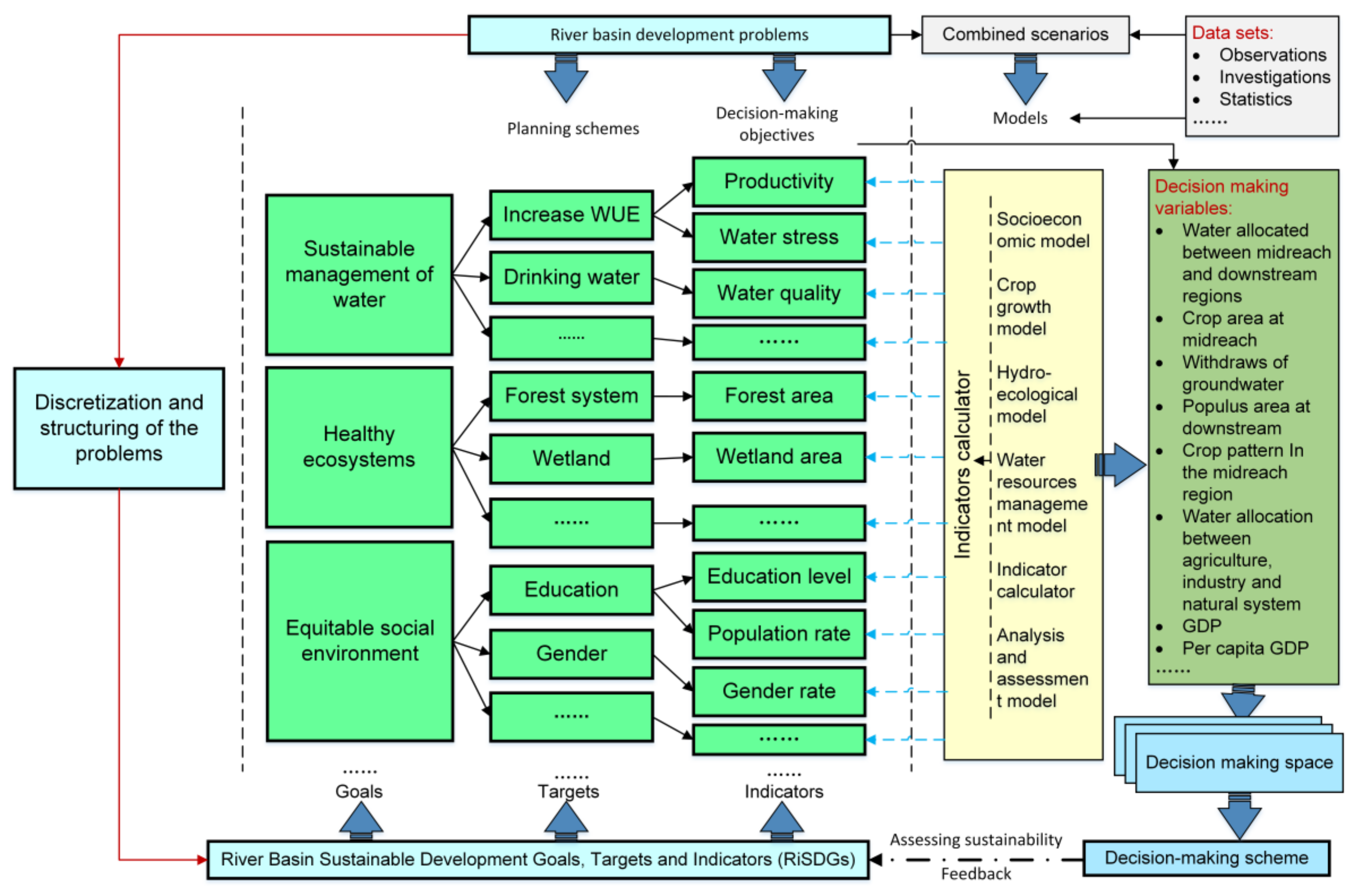
In the first part, river basin sustainable development goals (RiSDGs) are created by downscaling the SDGs to the river basin by means of seeking relationships between SDGs and the problems to dominate the sustainable development of the river basin. River basins are confronted with diverse key development problems. Examples include poverty, water scarcity, conflicts over water, losses of biodiversity, land deterioration, and environmental degeneration. All of these development problems (see light cyan box at top of
Figure 1) need to be embodied in the RiSDGs. However, in general, it is very different to directly quantify these problems because of ambiguous and little structure. Accordingly, these problems will initially be broken down into distinct questions that can be expressed quantitatively by means of the approaches—discretization and structuring of the problems (see light cyan box at left of
Figure 1)—that include Bayesian networks, cognitive or causal maps and decision maps [
37]. Then, these basic questions can provide a crucial link with goals, targets and indicators of the SDGs (see light cyan box at bottom of
Figure 1). In addition, river basic development problems can be quantified with planning schemes corresponding to targets of RiSDGs and decision-making objectives corresponding to indicators of RiSDGs (see green box at middle of
Figure 1). Thereby, sustainable development goals, targets and indicators are merged into decision-making processes by means of building relationships between decision-making, river basin development problems and sustainable development goals.
In addition, the changing demands of the development of river basins pose challenges for dealing with unpredictable events, especially extreme climatic, hydrological, and economic events and health-related events. Thus, the RiSDGs must have sufficient flexibility to adapt to the changing demands of the development of river basins. This flexibility indicates that stakeholders or decision makers can customize the RiSDGs freely in response to the problems that are faced in different stages of development. From a technique-based perspective, two approaches, which are large indicator spaces and integrated indicators, can be used to improve the flexibility of the overall method. The first approach provides indicators that are adequate for stakeholders or decision makers to build the RiSDGs. These indicators, which include not only the UN SDGs, but also other indicators identified by previous sustainable development research, cover nearly all of the problems involved in the development of river basins. The other approach can help the stakeholders or decision makers to add new indicators to the framework.
Scenarios are always created in response to river basin development problems. A tentative approach to promote better understanding of potential processes involved in the questions can be provided by means of analyzing the combined scenarios (see gray box at top of
Figure 1). The goal of constructing the combined scenarios is to identify the potential assumptions involved in quantifying the RiSDGs indicators. These assumptions are consistent with the goals and targets of sustainable development. Thus, decision makers can analyze the interactions between different elements of the natural and socioeconomic systems by proposing various assumptions. Accordingly, the scenario simulation helps in understanding how different possible strategies dominate the development process and result in the overcoming of cognitive biases regarding the effects of different decision variables on socioeconomic development.
However, scenario simulations require the support of models, and a hydrological model, an ecological model, a water resources management model and a socioeconomic model are integrated in the framework (see yellow box at middle of
Figure 1). These models can provide scientific estimates of key physical parameters and the rates of change in socioeconomic variables [
38,
39]. Thus, they simulate the interactions between natural and socioeconomic processes over a wide range of spatial and temporal scales. The results of these models can provide reliable information or data for use in decision-making processes, in that they calculate the state of each indicator included in the RiSDGs in different periods using the indicator calculator (see yellow box at middle of
Figure 1). For instance, crop water productivity is an agricultural economic indicator that is generated by the indicator calculator from crop yield and crop water demand, which can be estimated by the socioeconomic model. Note that the control variables that dominate the models are both key parameters of the scenarios and decision variables. The objective is to build a bridge between decision-making and sustainable development, i.e., decision makers can govern the trend of development of a river basin by selecting different decision-making strategies that affect the scenario parameters.
Making decisions is the basis of social behavior and steers development toward sustainability. However, when the scenario parameters change, a diverse array of decision-making schemes are generated, all of which correspond to decision variables (see dark green box at right of
Figure 1) that produce a unique development pathway. The sets of all of decision-making schemes make up the decision-making space (see light blue box at bottom of
Figure 1). The comparison of the goals that decision makers expect to achieve in the RiSDGs and the results from the models driven by a set of the parameters in a combined scenario shows whether the initial assumption on the scenario setting meets the requirements of sustainable development of a river basin. Sometimes, the overall performance of the coupled natural and socioeconomic systems may not be optimal, even though all of the indicators meet the requirements of development. By analyzing the tradeoffs among all parameters of the combined scenarios, an optimal decision-making scheme with high implementation capacity toward an adaptive development pathway can be identified (see light blue box at bottom of
Figure 1).
Consequently, by means of the integration of structured development problems, scenario analysis, modeling, the indicator calculator, the assessment of the level of sustainable development and decision-making processes, the performance of each indicator on the dimensions of the development of the coupled natural and human system is estimated; moreover, the sustainability of development of the RiSDGs at different levels (indicators, targets and goals) that cover a wide range of scales from individual communities to the river basin is measured in a broad sense. In addition, depending on the available data sets, which include observations, investigations and statistics, the state of any development stage (such as year resolution) can be obtained based on this framework to monitor the implementation of the RiSDGs. By monitoring the states of goals, targets and indicators of RiSDGs, some potential problems (such as water quality, groundwater table, etc.) can be founded in time; then, some key parameters of the scenarios can be adjusted to make a new adaptive decision-making scheme for the future. The supervisory mechanism can promote the implementation of decision-making schemes.
2.2. River Basin Sustainable Development Goals (RiSDGs) Based on the UN SDGs
RiSDGs provide common assessment indexes of sustainable development that estimate the sustainability of development within certain domains. The purpose of building RiSDGs is to improve the implementation of the UN SDGs at the river basin scale, rather than only performing assessments of sustainability. In general, assessment indexes of sustainability include the watershed sustainability index [
24], the ecoregion sustainable development index [
40], the water poverty index [
41], the livelihood vulnerability index [
42] and the human development index [
43]. These indexes can help decision makers or governments to better comprehend the current state of development, rather than to understand the causal relationships between goals and targets for the future. Nevertheless, to enable the implementation of the UN SDGs, recognizing the structure of goals, targets and indicators and the relationships between these features are vital prerequisites.
However, there are 17 goals, 169 targets and more than 230 indicators in the UN SDGs [
44], all of which were developed simultaneously to enable achievement of the goals in all of the relevant dimensions within the past 15 years. It is very difficult to complete this task. Accordingly, for the implementation of SDGs, it is more feasible to prioritize the different goals, targets and indicators according to their necessity and the importance of their contributions to sustainable human development and to examine these indicators at the scale of individual river basins. In addition, the following principles were followed in selecting the indicators: all of the indicators had to be (1) quantifiable, (2) rooted in the problems of interest, and (3) mutually independent.
Many studies have shown that the problems facing river basins are primarily related to water, ecosystems, the environment and socioeconomic factors. In particular, water is the root of all of these problems. Water is a primary concern in many studies on IRBM [
45]; water plays a vital role in most river basins, and it dominates economic, ecological and social development. However, ecosystems and socioeconomic activities are two agents that consume water. Previous studies have shown that the rapid development of one agent restricts other agents [
46,
47,
48,
49,
50], i.e., the development of two agents will show a seesaw pattern. Sustainable development is intended to seek tradeoffs between pairs of agents at the river basin scale which will require the development of abilities. Therefore, we present five categories of RiSDGs from a system viewpoint in order to simulate the seesaw pattern between indicators from different systems (hydrology, ecology, society, economic, data), which are water-related, ecosystem-related, socioeconomic-related, ability-related and data-related RiSDGs (
Table S1).
Most of the goals, targets and indicators that are involved in the first three categories can be found in SDGs. Four goals related to water (Goals 6, 11, 12 and 14) were proposed in the SDGs, which are described in detail as nine targets and 11 indicators. These indicators cover various socioeconomic segments that range from the basic demands of living to international cooperation. Examples include the safety of drinking water, water-use efficiency, water withdrawal and supply, integrated water management, water-related ecosystems, the participation of local communities in water management and water-borne diseases. In addition, ecosystems are embodied by two goals (14 and 15) related to SDGs, covering 17 indicators, which emphasize the protection of biodiversity, the sustainable utilization of fisheries and the protection and restoration of land- and ocean-based ecosystems. Almost every SDG can be related with socioeconomic issues. Most of the concrete indicators (such as water use efficiency, proportion of population below the international poverty line, maternal mortality ratio, forest area as a proportion of total land area, etc.) can be directly applied to a river basin, or an even smaller spatial scale (such as county, community). However, some indicators need to be further clarified according to the features and the socioeconomic conditions of the individual river basin. For example, for indicator 2.1.1—the prevalence of undernourishment, standards of undernourishment need to be defined more clearly according to socioeconomic conditions at the river basin. In indicator 15.2.1—progress towards sustainable forest management, some quantifiable indicators, such as forest protected areas, forest monitoring network coverage area, etc., are taken into account in the related-ecosystem indicators rather than sustainable forest management which is an ambiguous conception.
In addition, we think that ability-related and data-related indicators also play important roles during the implementation of RiSDGs. Abilities include both soft abilities and hard abilities. Soft abilities focus on combinations of cognition, innovation, decision-making and implementation capacity, whereas hard abilities emphasize observations, infrastructure, education and production that are related with action-related behaviors. Meanwhile, the soft abilities can be estimated by the indicators including a proportion of the employed scientific and technological personnel in the total population, a proportion of the research budget allocated to science and technology in GDP, etc. (see
Table S1). In addition, there are some indicators contributing to hydraulic engineering, ecological engineering, environmental engineering, various observation system (such as hydrology, ecosystem, meteorology, etc.), etc., that can indicate the development of the hard abilities of a river basin (see
Table S1).
Data plays a critical role in river basin development in regard to decision-making, planning, strategic options, policy formulation and assessment. However, lots of data is not applied in river basin management because it is controlled by agencies (e.g., networked big data, satellite data, and socioeconomic data), scientists (e.g., in situ observations, reanalysis data, and simulation output), and engineers (e.g., engineering data and reports on manufacturing, design, and processes). Data sharing, processing, quality testing and use efficiency will become the key indicators that influence the implementation of RiSDGs.
2.3. Examples of RiSDGs
Although the RiSDGs were proposed based on the UN SDGs, not all of the goals and targets are adaptable to each river basin. Both of the general RiSDGs characteristics and problems of each river basin determine the goals and targets for particular basins.
For open river basins where the river water enters into the ocean or estuaries, sustaining estuarine or coastal ecosystems and preventing salinity intrusions should be taken into account [
51,
52] in addition to the goals regarding economic growth, social equity, biodiversity protection, etc. Examples of such river basins include the Amazon, Mississippi, Nile, Yangtze, and Yellow River Basins. However, within closed (endorheic) river basins, the SDGs and targets focus on integrated water resources management, economic growth, biodiversity protection, social equity, the ecological environment and co-development among the upstream, middle and lower reaches [
47,
53,
54,
55,
56], as well as reaching the international poverty line of
$1.25 per day and water resources per capita. Examples include Lake Eyre, Chad River, and Heihe River Basins. In addition, many transboundary river basins exist that contain parts of different administrative regions, including counties, states and countries. The grand challenges for sustainable development of these river basins include addressing the socioeconomic and ecological problems of each administrative region at the river basin scale, reasonable allocation of water resources to the administrative regions, and protecting and restoring the life support system at all levels [
55,
57]. In these cases, the SDGs and targets are concerned with cooperation, integrated water management, economic growth, ecological protection, preventing losses in biodiversity, sustainable production and consumption that are implemented on all levels.
The key goals and targets of the sustainable development of the three river basins that contribute to the Amazon (
Table S2), Nile (
Table S3) and Heihe river (
Table S4) basins are described according to the various roles that the river basins play in the natural and socioeconomic systems to guide the establishment of SDGs in river basins around the world.
(1) Amazon River Basin
The Amazon River Basin contributes 15–20% of the global freshwater flowing into the oceans [
58] and plays a crucial role in the global climate system, biodiversity, the carbon cycle and questions of national and international security. In recent decades, human activities, including deforestation, mineral extraction, hydraulic engineering, agriculture and immigration have caused substantial negative impacts on hydro-geological processes (including soil erosion and the hydrological cycle) and biochemical processes (including the carbon and nitrogen cycles and water pollution). Accordingly, water resources management, ecosystem protection, sustainable economic activities and population growth are the major factors that influence the sustainable development of this basin. The intricate interplay among these factors creates new challenges for responding to the UN SDGs, the implementation of which requires long-term cooperation and support from various agents, including governments, organizations, economic agents and everyone on community, county, national and global scales. The key goals and targets are described in detail in
Table S2 in order of priority.
(2) Nile River Basin
The Nile River Basin is drained by the Nile River, which is the longest transboundary river in the world. This basin includes parts of 11 riparian countries that feed 257 million people [
55]. It plays an important role in the socioeconomic system of Africa because the Nile River is the source of culture and benefits. Agriculture dominates the socioeconomic development of many states in the Nile River Basin; this basin contributes between 12% and 43% of the Gross Domestic Product (GDP) and between 32% and 94% of the labor force of these states [
53]. The GDP of all of the basin states is increasing with a high growth rate. However, poverty is still a major social problem in the Nile River Basin; more than 40% of the population lives under the international poverty line of 1.25 dollars per day. In addition, increasing population and economic growth drive changes in land cover, especially increases in the area of irrigated agricultural land. These changes lead to environmental degradation and high demand for water, energy, food and services [
47,
54,
56]. The enormous dependence on water increases vulnerability to climate-related extreme events and the uncertainty of water resources management. Accordingly, sustainable water resources management has become a vital factor that influences economic development, the environment and social stability. Many policies and strategies have been developed by the Nile River Basin Initiative (NBI) under the Nile River Basin Sustainability Framework [
59], including environmental flow management, wetland management strategies, climate change strategies and environmental and social policies. Based on the UN SDGs, some key goals and targets are proposed in
Table S3 for improving the implementation of sustainable development in the Nile River Basin.
(3) Heihe River Basin
The Heihe River Basin is the second largest endorheic drainage basin in China. It is characterized by a variety of landscape types, including forested mountains, artificial oases and desert areas. From the upstream area to the lower reaches, it is crossed by the Heihe River, which has its source in the Qilian Mountains and flows into a terminal lake (Lake Juyan). Within the basin, the consumption of water resources occurs primarily in the middle reaches. Due to climate change and human activities, the surface area of Lake Juyan has decreased rapidly since the middle of the last century, and the lake dried up in 1992 [
60]. In addition, increases in population and economic growth have led to over withdrawal of water resources and consequently, the degradation of ecosystems and frequent sandstorms in the lower reaches of the basin. In addition, the conflicts of water use among life, industry, agriculture and ecology have become major challenges to socioeconomic development in whole river basin. Although a water saving technique and water agreement have been applied in the Heihe River Basin over the past decades, problems including water conflict and ecosystem deterioration have not be alleviated. Accordingly, indicators, such as water allocation between sectors and regions, ecosystem protection, industrial structure adjustment, etc., will become the key determinants that influence sustainable development of the basin. The key goals and targets for sustainable development of the Heihe River Basin are described in
Table S4.
3. Implementation of SDGs at the River Basin Scale
Implementation of the RiSDGs requires actions that depend essentially upon appropriate decision-making schemes. Decision-making plays a very important role in sustainable development because it is a key driver of the behavior and actions of societies and individuals including, but not limited to, policy formulation, strategic planning, economic activity, management, communication, and living. Decision makers need to understand the risks and uncertainties of future conditions to make better choices, since it is usually costly to reverse the outcome of any decisions.
Scenario analysis, which is a virtual programming method, helps us to understand the causally linked relationships between the elements contained in development and to separate certainties from uncertain factors. Hypotheses are the core of scenario analysis; nevertheless, scenario analysis is based on complex cognitive processes that integrate post-experience and cognitive facilities into future developments. Scenario analysis is intended to result in greater understanding of the interrelationship of intertwined goals, targets and indicators and to analyze their impacts on one another and the relevant uncertainties. Close connections exist between scenarios and indicators. In the framework used in this study, there are five types of scenarios for decision analysis that include climate change, water resources management, land use change, socioeconomic development and industrial and urban development. These scenario types form various combinations of scenarios, depending on the needs of decision makers. Each combined scenario provides a set of parameters that determine the trend of development of corresponding indicators by means of the models that contribute to socioeconomic and hydro-ecological development in parallel. Moreover, each combined scenario corresponds to a specific decision-making scheme. Based on different parameterizations of those combined scenarios and the simulated results and consequences, improved development pathways can be identified.
3.1. Construct Combined Scenarios
A climate change scenario is regarded as an independent factor that affects ecosystems and socioeconomic systems via precipitation and temperature. In the literature, future changes in temperature and precipitation have been simulated using greenhouse gas emission scenarios developed for Representative Concentration Pathways (RCPs) [
61], for example, RCP8.5, RCP6, RCP4.5 and RCP3. These scenarios represent different levels of radiative forcing after 2100. The temperature and precipitation changes are further used to drive hydrological models, and individual hydrological processes are assessed in terms of surface run-off, ground run-off, soil moisture, evapotranspiration, etc.
Many river basins face problems regarding water management, such as water use conflicts among regions and sectors, life and property losses caused by extreme hydrological and climatic events, water-related diseases caused by polluted water [
62], ecosystem degradation [
63,
64], socioeconomic impacts [
65], and water quality in drinking water supply [
66], etc. In addition, water is also an important reason for cooperation between regions and sectors. Therefore, following the hydroclimatic scenarios, water resources management scenarios are integrated into the framework.
The water resources management scenario consists of four sub-scenarios that include water allocation among the regions and sectors, improvements in hydraulic engineering techniques, water resources management methods and safe drinking water for all (see
Table 1). The objective of the water resources management scenario is to analyze the impacts of water policies, water rights, water demand, water supply and water-related education on the development of river basins by means of the integrated hydro-ecological model. Key parameters contained in the sub-scenarios are also the control parameters of the models and the central factors that influence the development of river basins (see
Table 1), for example, water rights are considered to be an agreement among the water-use agents to allocate water [
67,
68]; water demand between regions or sectors also influences water allocation that is decision variable. They can then further increase the availability and productivity of water according to the water market. Changes in water rights among different water-use agents may influence industrial structure and ecosystems and even causes conflicts over water, which then alter the track of development of river basins.
The socioeconomic development scenario focuses on understanding how social behaviors and the economic system affect the co-development of natural and human systems in river basins by coupling the socio-economic model, land use model, water resources management model and hydro-ecological model. Thereinto, the integrated model can simulate how individual and social behaviors (deforestation, wildlife trade, policy, etc.) influence hydro-ecosystems (biodiversity, the ocean biological stock, water quality, precipitation, run-off, etc.) and socio-economic systems (resources allocation, GDP growth, human welfare, pollutant discharges, population growth, etc.). Accordingly, there are three sub-scenarios in the socioeconomic development scenario, which specifically cover population development, economic development and societal progress. We think that the increasing population and GDP are the main drivers that cause the problems in ecosystems, the environment and society. In addition, water productivity, and the structure and education level of the population also play important roles in the development of river basins. These factors, as key parameters, are combined in the socioeconomic development scenario and are also inputs of integrated model (see
Table 1).
Furthermore, two sub-scenarios—the optimization of industry structure and urban development—are included in the industry and urban development scenario. Industry structure is a significant indicator for measuring economic development level of river basin and also a key factor of dominating the trade-off between economic growth and ecosystem system. Adjustment of industry structure can lead to profound effects on the distribution of precipitation and temperature in space and time [
69,
70,
71], water resources management [
72], socioeconomic systems [
73], ecosystems and biodiversity [
74,
75]. In addition, some economic policies on adjustment of industry structure, such as shrinking area of farmland, developing low-carbon industrial sectors, etc., can reduce the conflict regarding water use between the industrial, agricultural and environmental sectors. In addition, the rate of progress in science and technology is a key determinant of economic growth; scientific and technological innovation substantially increases economic productivity, improves health systems and infrastructure and alters the means by which humans connect and communicate, thus affecting the entire socioeconomic system. Moreover, these key parameters are also control variables (input variables) in an integrated hydro-eco-socioeconomic (HESE) model [
76,
77,
78].
Land use changes are considered to be a key indicator of human impacts on nature. The land use scenario includes two sub-scenarios that involve land use structure and land use change, respectively. The former focuses on land use types—approximately 48 land use types that correspond to different industrial sectors are considered. Examples include farmlands, wetlands, educational areas, cultural and entertainment districts, banking businesses, manufacturing facilities, etc., as well as non-productive land use types, particularly deserts, forests, rivers, lakes, reservoirs, etc. Nevertheless, subsequent concerns with the rates of change of different land use types imply changes in industrial structure and development policies. Two key parameters are the input variables of the land use model.
Various combined scenarios can be constructed by mixing the sub-scenarios and selecting different parameterizations, according to the needs of the decision makers and the development-related features of the river basin. Each combined scenario then is fed into the HESE model and results in a data set that indicates the state of development of the river basin. In addition, the data set is also a basis for choosing pathways of sustainable development.
3.2. Selection of Changing Development Pathways
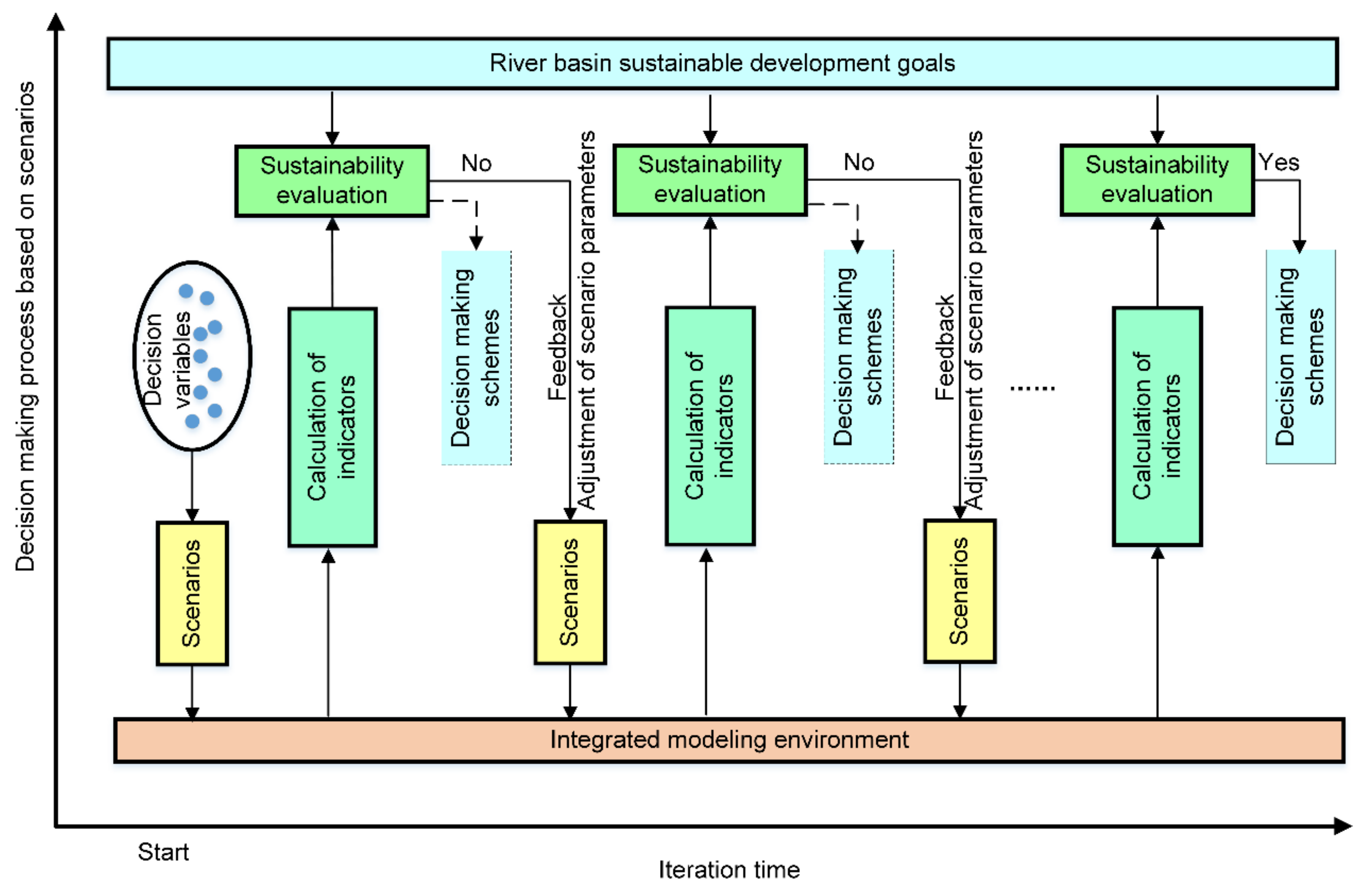
Decision-making involves a process of optimization and making better choices from changing development pathways. In the framework, an integrated dynamic parameter adjustment approach is used to regulate the key parameters of the sub-scenarios within allowed intervals to steer the trend of development according to feedback from the results of the models at different points in time (see
Figure 2). We initially assume a set of values for the parameters of the scenarios according to experience and the decision-making problem being considered. Next, these parameters are entered into the HESE model, and another set of values that are consistent with the indicators is generated by the indicator calculator based on the results of the HESE model. A state of sustainable development is then estimated in the first development stage (such as first year, first month) by using the sustainability assessment model after comparing the predefined target value and the results from the HESE model. If this state meets the requirements of sustainable development of the river basin, the previously assumed scenario parameters become a decision-making scheme; otherwise, the values of these parameters are adjusted and fed back into the HESE model. By means of this cycle, a set of scenario-related parameters is eventually identified that corresponds to the requirements of sustainable development of the river basin, and an appropriate decision-making scheme is formed (see
Figure 2). In the cycle selection process, the interaction mechanism between the hydrology, ecosystem and socioeconomic systems can be better understood by the decision makers or stakeholders by means of regulating the key parameters of the scenarios to reduce the uncertainty of their perceptions. Moreover, the results from the scientific models can provide many key elements, such as run-off, water demand, GDP, etc., to assist the decision makers or stakeholders to make choices regarding river basin management and planning, to reduce the risks of decision-making. As part of this process, two factors—the sensitivities of the key parameters and the weights of the indicators—play important roles in the regulation of these parameters and the calculation of the indicators.
The sensitivities of the parameters considered in this process influence the dynamic adjustment of the parameters, and the different adjustment increments for each parameter are determined by their sensitivities. A global sensitivity analysis approach, the Extended Fourier Amplitude Sensitivity Test (EFAST), can be used to determine the sensitivity distribution of the key parameters of the sub-scenarios by means of analyzing the relationships between their first-order sensitivity index (FSI) and total sensitivity index (TSI) values [
79]. These values are calculated to guide the parameter adjustment process. In addition, EFAST also is applied to quantify the sensitivity of each indicator to the target and to quantitatively describe the relationships among the indicators.
The weight determinations are divided into three weighting systems that correspond to goals, targets and indicators, respectively. Decision makers can provide subjective assessments of the initial weights for the different weighting systems, according to the development demand of individual sectors or river basins. These subjectively assigned weights are also primary evidence that exposes the preferences of the decision makers. When subjective weight values are lacking, objective weight values can be identified through TSI normalization [
79]. In long-term assessments, the importance of the goals, targets and indicators may vary between the different development periods (for example, 1-year, 5-year, and 10-year periods); thus, a matrix of weights must be created for the different weighting systems during different development periods using the TSI values from the different development periods.
4. Conclusions
The goals, targets and indicators of the SDGs cover nearly all aspects of hydrological–ecological–socioeconomic systems at the river basin scale. However, the SDGs must be downscaled to enable IRBM. In the paper, we proposed that river basins are an appropriate spatial scale to promote the post-2015 development agenda of the UN and presented a framework that aids decision makers or policy makers to downscale the SDGs to a river basin level to facilitate the implementation of the SDGs by means of the features and problems of river basins. The framework includes two main parts that consist of establishing RiSDGs by converting the indicators of the SDGs into the sustainable development of a river basin based on the features and the problems of the basin and exploring sustainable development pathways by means of integration of the models and the scenarios analysis.
Based on analysis of the SDGs, we defined RiSDGs by five aspects, specifically water, ecosystems, socioeconomic development, capabilities and data, based on the special features of a class of river basin. Many indicators in the SDGs can be directly used to guide the sustainable development of a river basin; however, some indicators need to be further clarified according to the features and the socioeconomic conditions of an individual river basin before they can be applied. These goals, targets and indicators correspond to the practical problems of river basin development at multiple levels and scales. In addition, data-related indicators can be considered to be important roles in monitoring the implementation of the RiSDGs and supporting decision-making. Data sharing, processing, quality testing and use efficiency will become the key indicators in RiSDGs. Three examples have been presented, specifically the Amazon, Nile and Heihe River Basins. Although the RiSDGs cannot cover all issues encountered in river basin development, we expect that they can guide decision makers or stakeholders to establish SDGs that are consistent with the features of their own river basins.
In addition, an approach for promoting actions based on the RiSDGs was integrated into the framework. This integration yields an appropriate scheme for decision-making that guides development toward the expected pathway by combining scenario analysis and decision-making processes. The scenario environment included five scenarios, 17 sub-scenarios and 29 key parameters. The scenarios and sub-scenarios can be assembled with a diverse array of combined scenarios to adapt to the changing problems of river basins. Each combined scenario corresponded to a set of decision variables that were contained in a decision scheme. By adjusting the key parameters of the scenarios, a number of feasible resolutions that are consistent with the goals of sustainable development were generated. In essence, this approach helps decision makers to understand future risks and uncertainties and then formulate a sustainable plan of action for IRBM. Furthermore, to enable better simulation of decision-making processes, the EFAST model was included in the framework to test the sensitivity to key scenario parameters.

 ,
, 


