

Spatial Pattern of Residential Carbon Dioxide Emissions in a Rapidly Urbanizing Chinese City and Its Mismatch Effect



 ,
,  and
and
Abstract
1. Introduction
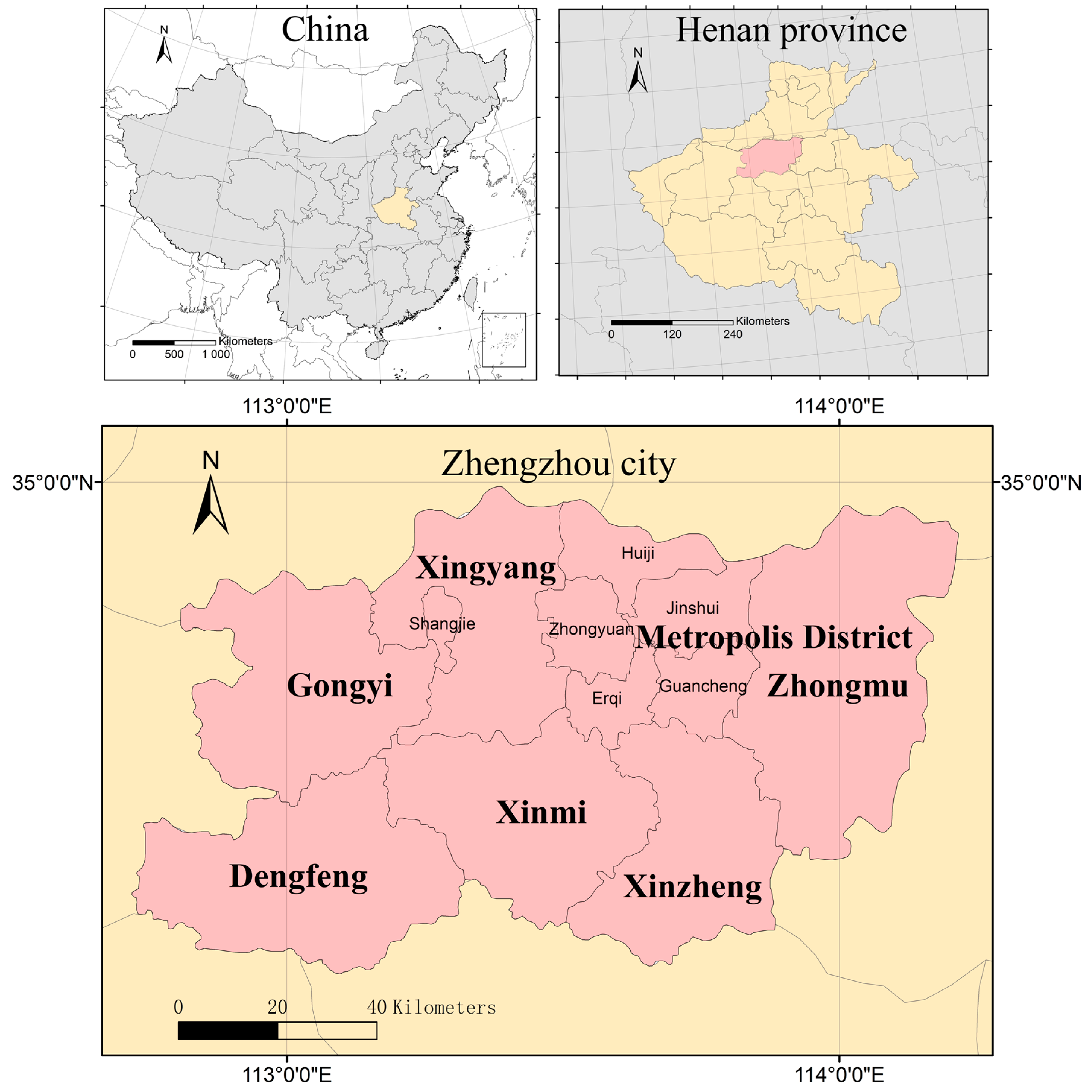
2. Research Area
3. Methods
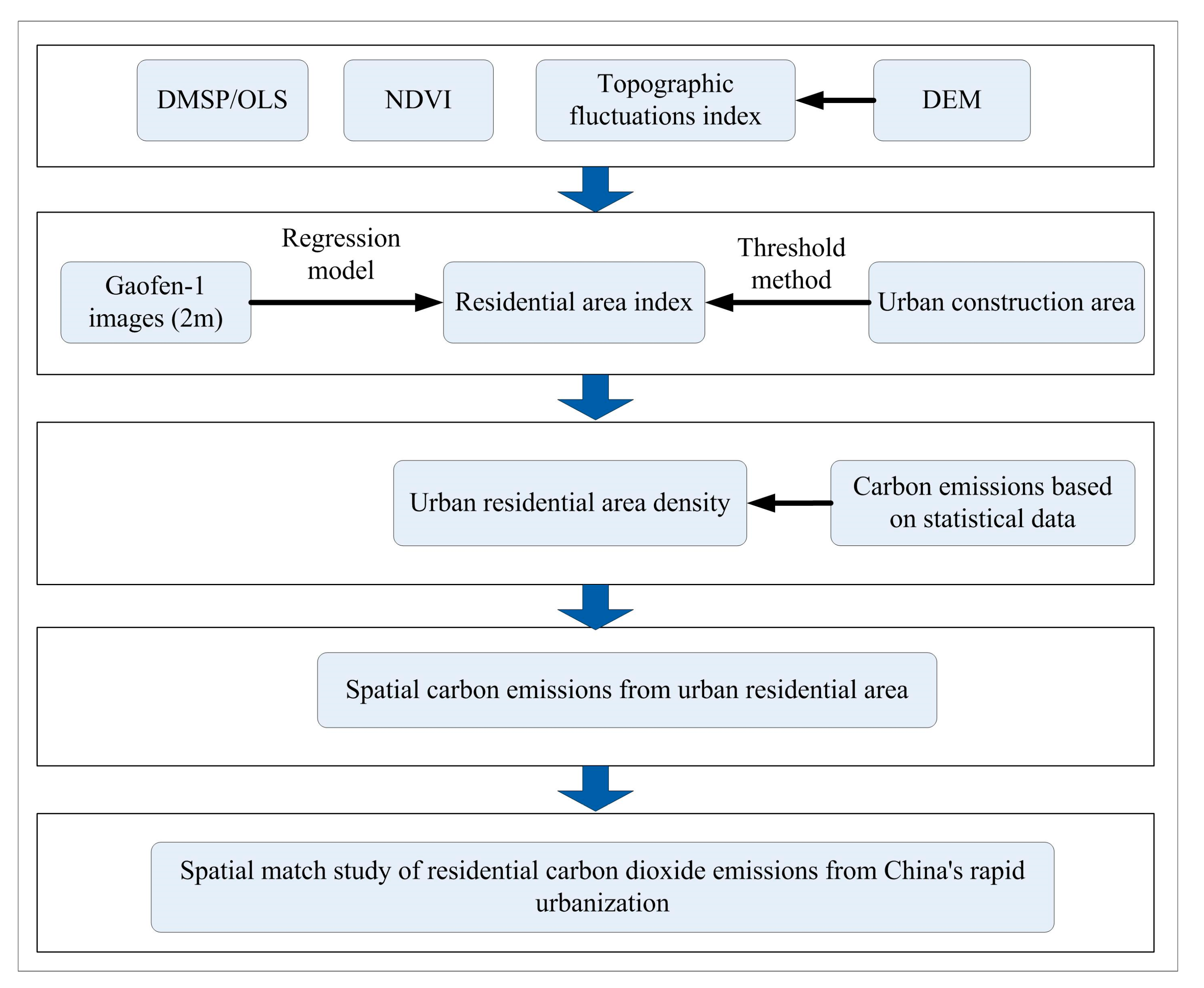
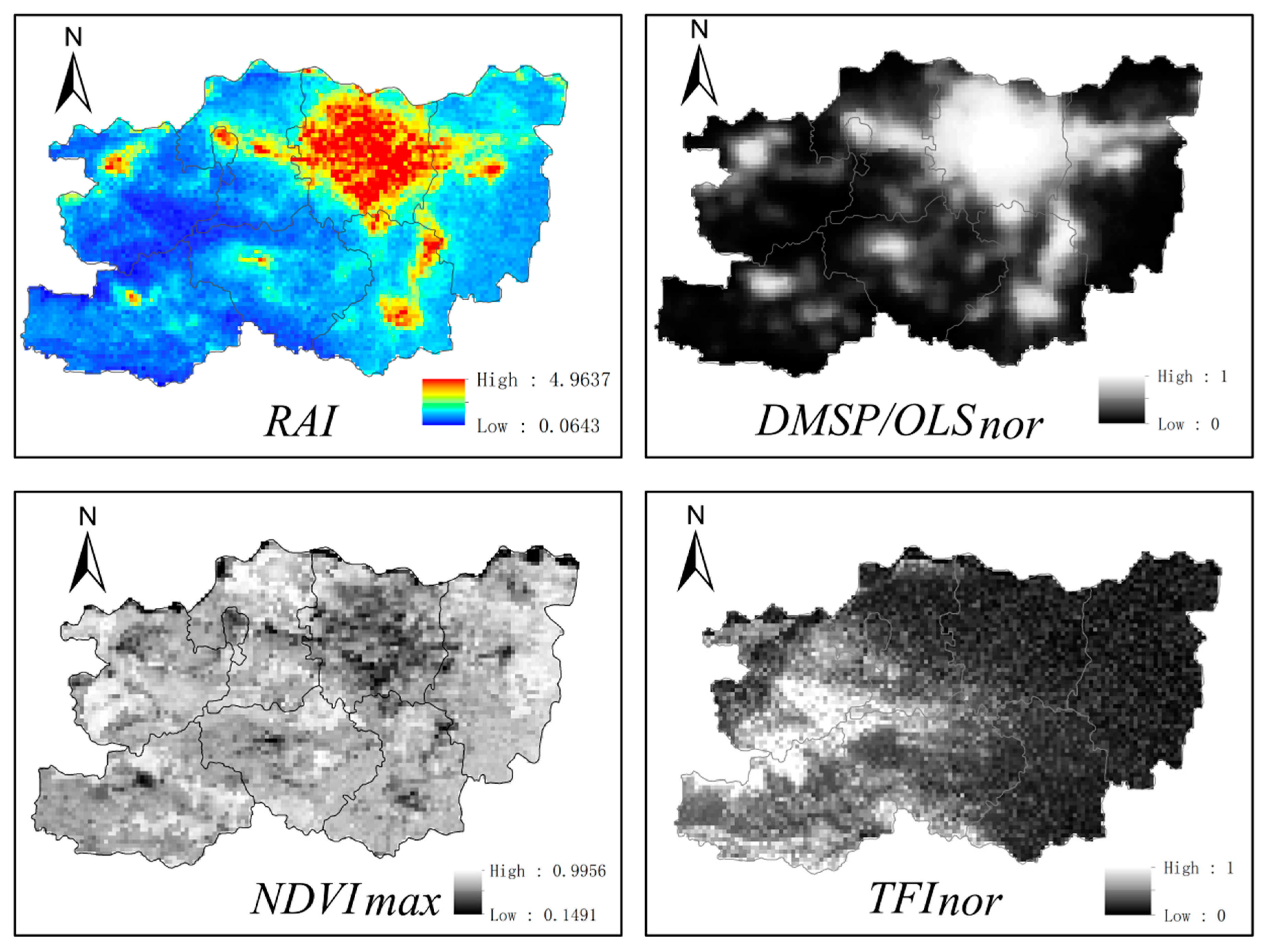
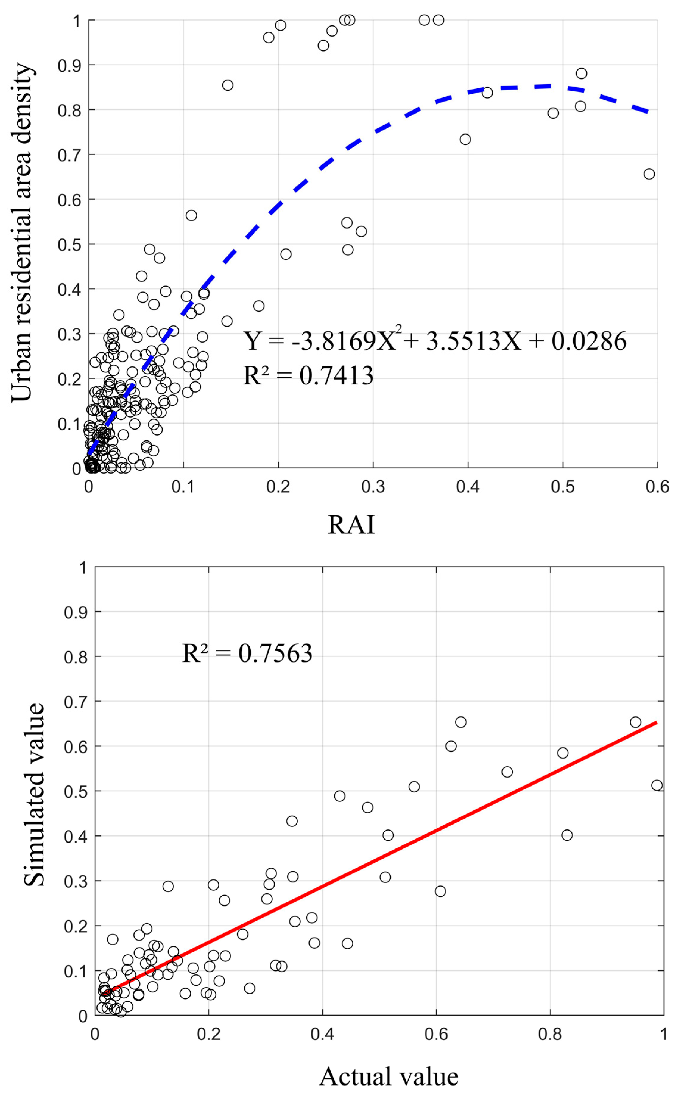
3.1. Urban Residential Area
3.2. Spatial Carbon Emissions
3.3. Identifying Spatial Patterns Using SDE
4. Results and Discussion
4.1. Urban Residential Carbon Emissions
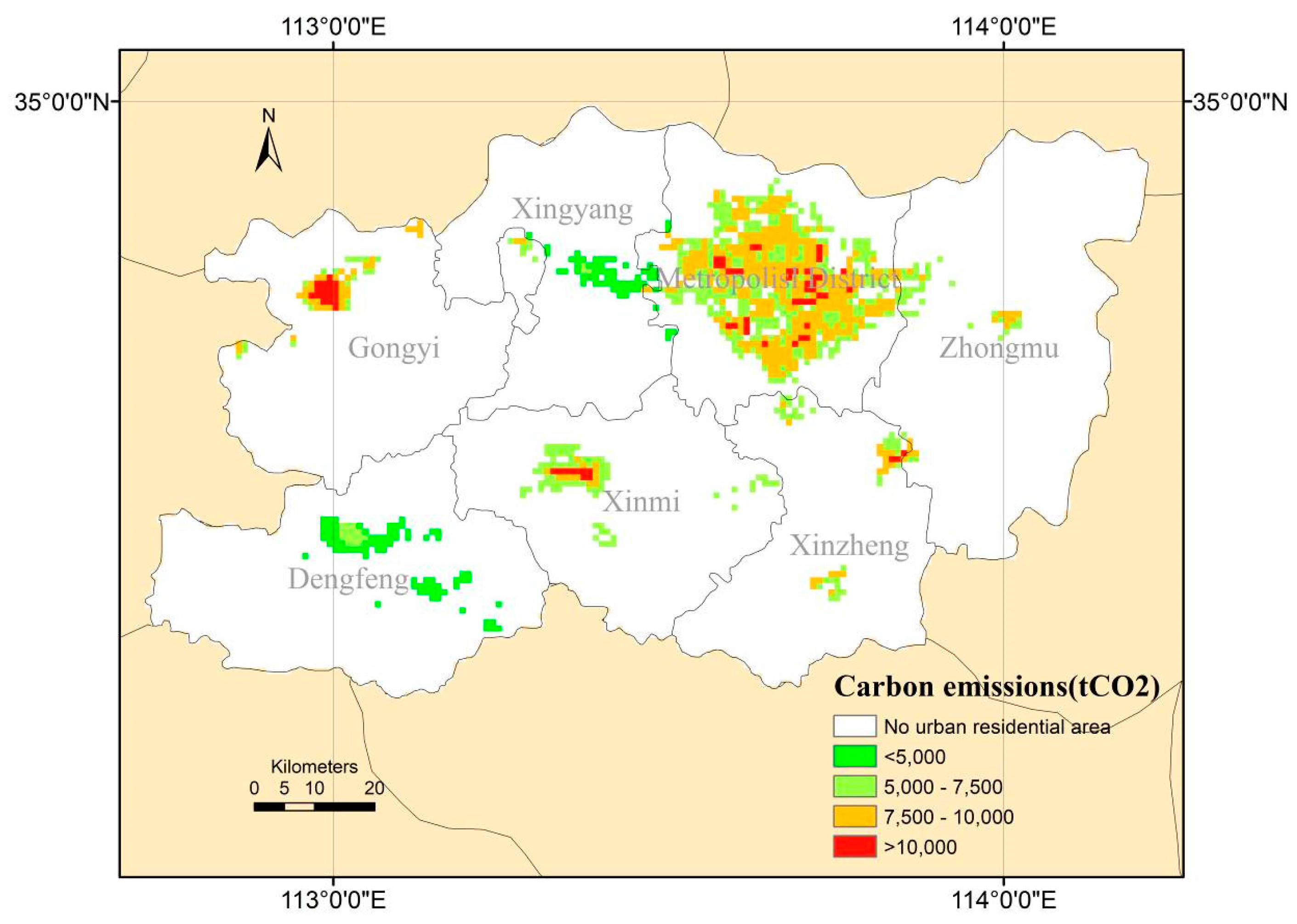
4.2. Spatial Carbon Emissions from Urban Residential Area
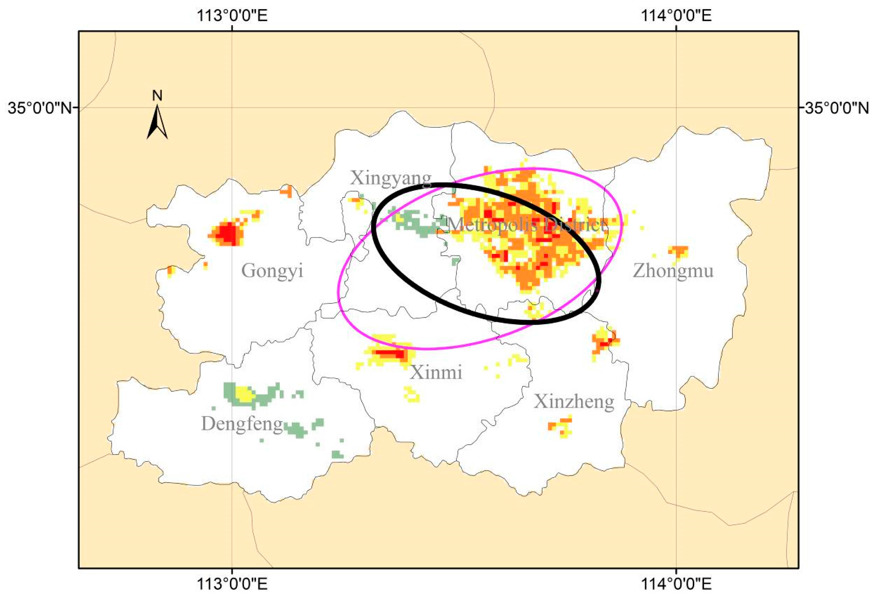
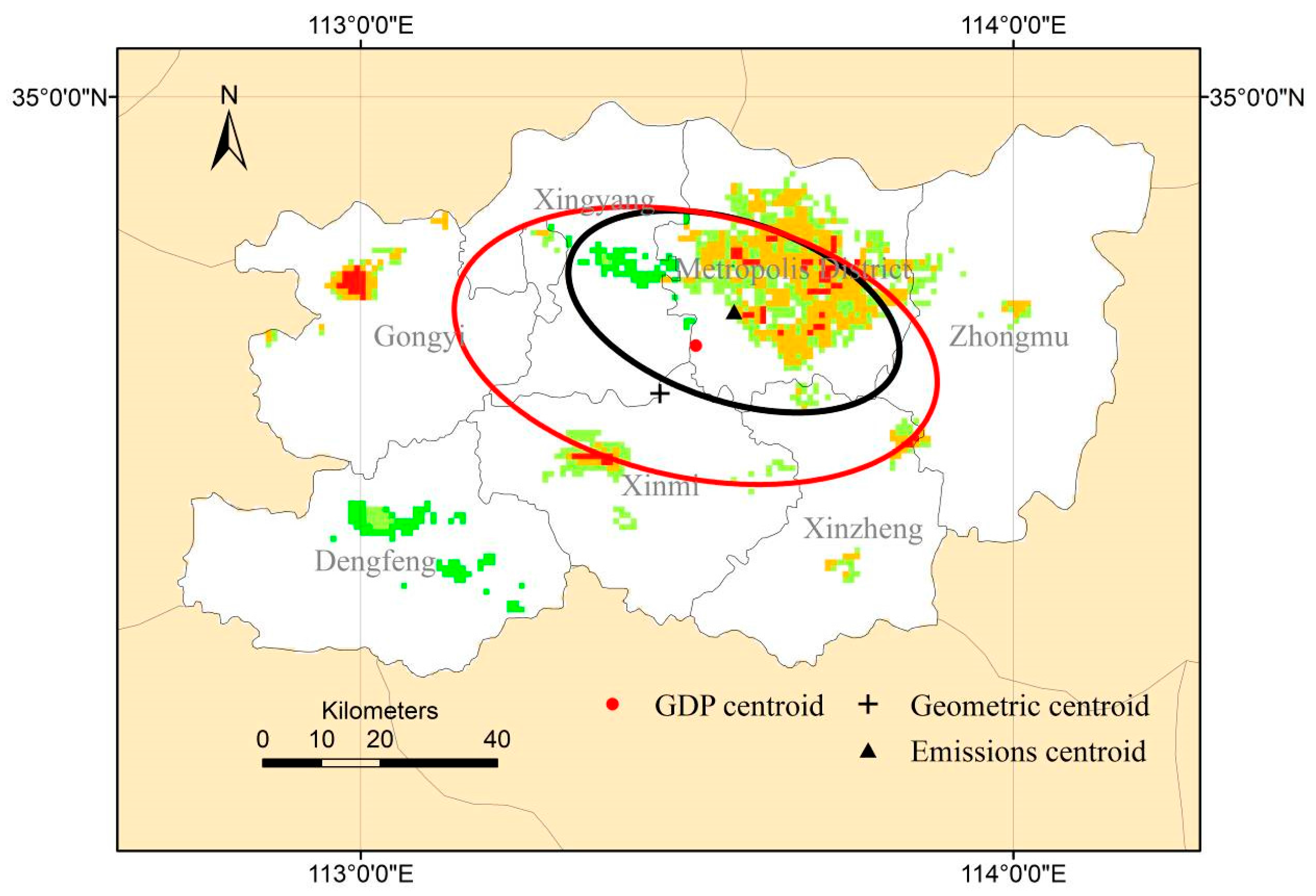
4.3. Spatial Patterns Identified with SDE
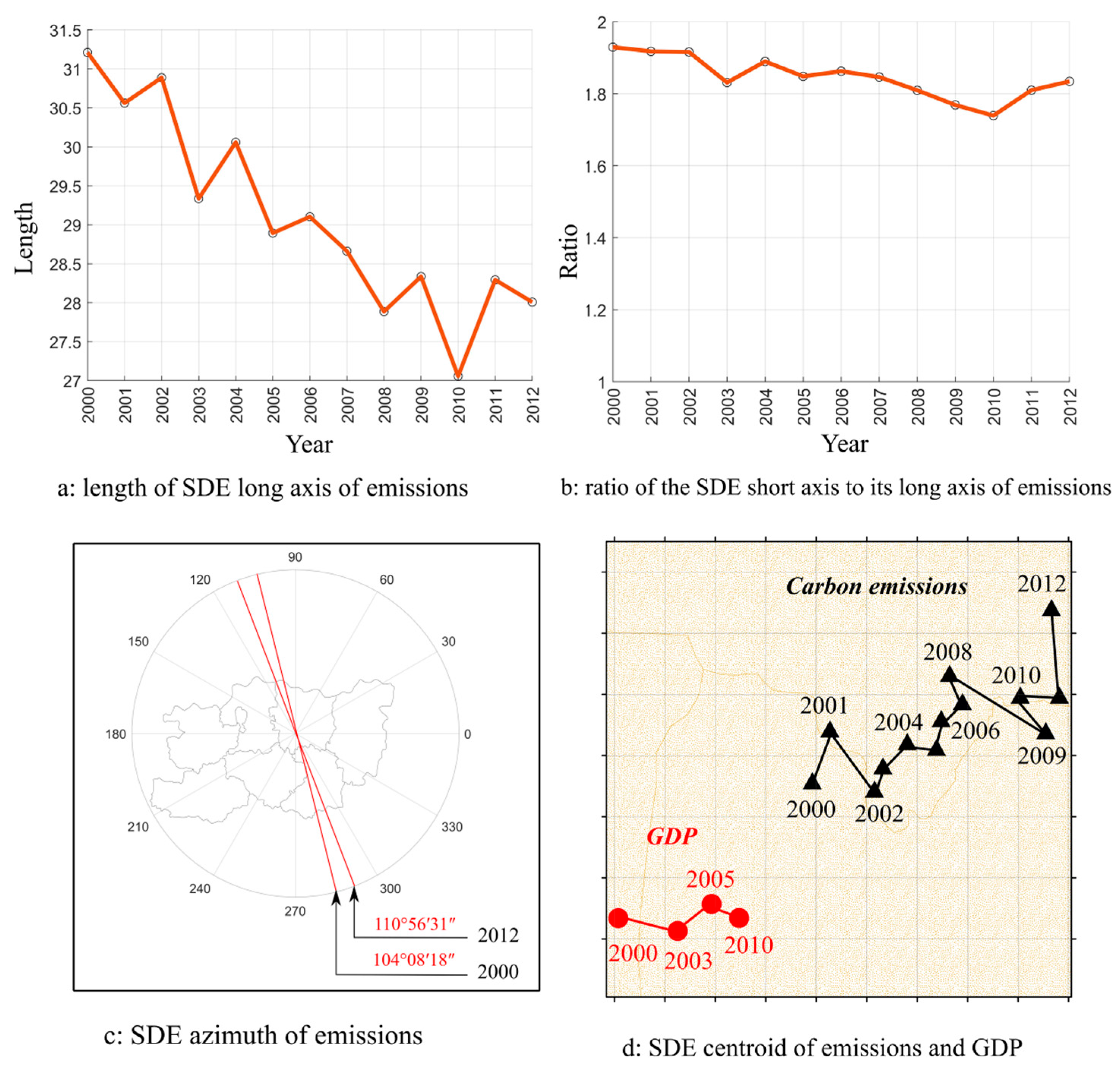
4.4. Spatial Patterns Evolution Identified with SDE
5. Conclusions
- (1)
- The traditional method of analyzing spatial carbon emission patterns, based on statistical data, cannot accurately reflect these heterogeneous patterns during rapid urban development. For example, since 1990, the Ministry of Land and Resources has been releasing annual data on urban areas within China’s territories. However, the data are only at the level of the country’s administrative units and lack detailed spatial information. The new type of remote sensing data based on night-time lights served as the data source for our study, which allowed us to address the issue of heterogeneity to a certain extent.
- (2)
- Zhengzhou is undergoing rapid urbanization, which is accompanied by fast expansion of built-up areas and consequently of spatial patterns of emissions. This is especially true for ZNA and ZAEZ, in which urbanization has been faster than scheduled. This makes the acquisition of timely and accurate urban spatial information, for example carbon emissions from urban residential areas, more difficult. It is always necessary to have information on the amount of energy used for both night-time lights method and traditional statistical method. However, the former could reflect the spatial characteristics of emissions which are directly associated to urban density change in a more timely and high spatial resolution manner compared to the latter since the emission intensity at a pixel was scaled by multiplying the normalized density with the total emission of a district. This information is of significant contribution when promoting the development of low-carbon cities and reducing the risks of rapid urbanization.
- (3)
- An important issue is why spatial mismatch between emissions and GDP would exist in Zhengzhou of a rapidly urbanizing Chinese city. In addressing this question, it is important to understand that the local government in China runs key sectors of the urbanization process directly and the rest indirectly and thus, inevitably, exercises a decisive role in the development of the urban system [59]. As such urbanization in Zhengzhou features the government-directed migration process of the population organizing in urban areas, which influences the spatial distribution of residential emissions. One of the “side-effects” generated in that process is the lagging of economic activities such as GDP. As a result there is evident mismatch in spatial pattern between emissions and GDP.
Acknowledgments
Author Contributions
Conflicts of Interest
References
- Henderson, J.V. Cities and development. J. Reg. Sci. 2010, 50, 515–540. [Google Scholar] [CrossRef] [Scilit] [PubMed]
- National Development and Reform Commission. Population and Social Development Review 2014: Population Changes and Public Services, 2014; National Development and Reform Commission: Beijing, China, 2015. [Google Scholar]
- Northam, R.M. Urban Geography; John Wiley & Sons: New York, NY, USA, 1979. [Google Scholar]
- Wei, Y.D.; Ye, X. Urbanization, Land Use, and Sustainable Development in China. Stoch. Environ. Res. Risk Assess. 2014, 28, 755. [Google Scholar] [CrossRef] [Scilit]
- Gao, J.; Wei, Y.H.D.; Chen, W.; Yenneti, K. Urban land expansion and structural change in the Yangtze River Delta, China. Sustainability 2015, 7, 10281–10370. [Google Scholar] [CrossRef] [Scilit]
- Qian, J.; Peng, Y.; Luo, C.; Wu, C.; Du, Q. Urban land expansion and sustainable land use policy in Shenzhen: A case study of China’s rapid urbanization. Sustainability 2016, 8, 16. [Google Scholar] [CrossRef] [Scilit]
- Wan, L.; Ye, X.; Lee, J.; Lu, X.; Zheng, L.; Wu, K. Effects of Urbanization on Ecosystem Service Values in a Mineral Resource-Based City. Habitat Int. 2015, 46, 54–63. [Google Scholar] [CrossRef] [Scilit]
- Cheng, Y.; Wang, Z.; Ye, X.; Wei, Y.D. Spatiotemporal Dynamics of Carbon Intensity from Energy Consumption in China. J. Geogr. Sci. 2014, 24, 631–650. [Google Scholar] [CrossRef] [Scilit]
- Kain, J.F. Housing segregation, negro employment, and metropolitan decentralization. Q. J. Econ. 1968, 82, 175–197. [Google Scholar] [CrossRef] [Scilit]
- Giuliano, G. Is jobs-housing balance a transportation issues? Transp. Res. Rec. 1991, 13, 305–312. [Google Scholar]
- Cervero, R. Jobs-housing balance revisited: Trends and impacts in the San Francisco Bay Area. J. Am. Plan. Assoc. 1996, 62, 492–511. [Google Scholar] [CrossRef] [Scilit]
- Handel, M.J.; Valerio, A.; Sánchez Puerta, M.L. Accounting for Mismatch in Low-and Middle-Income Countries; World Bank: Washington, DC, USA, 2016. [Google Scholar]
- Lowe, K.; Mosby, K. The conceptual mismatch: A qualitative analysis of transportation costs and stressors for low-income adults. Transp. Policy 2016, 49, 1–8. [Google Scholar] [CrossRef] [Scilit]
- Wang, L.; Duan, X.J.; Tian, F.; Qin, X.H. Study on the relationship between population and economic spatial distribution in Yangtze River Delta. Econ. Geogr. 2009, 29, 1619–1623. [Google Scholar]
- Zhou, Y.; Tu, J.J.; Lu, D.B.; Yan, X.; Wu, J.T. Study on the relationship between population and economic spatial distribution and its dynamic in Chongqing. Econ. Geogr. 2011, 31, 1781–1785. [Google Scholar]
- Ihlanfeldt, K.R.; Sjoquist, D.L. The spatial mismatch hypothesis: A review of recent studies and their implications for welfare reform. Hous. Policy Debate 1998, 9, 849–892. [Google Scholar] [CrossRef] [Scilit]
- Baumgartner, D.; Schulz, T.; Seidl, I. Quantifying entrepreneurship and its impact on local economic performance: A spatial assessment in rural Switzerland. Entrep. Reg. Dev. 2013, 25, 222–250. [Google Scholar] [CrossRef] [Scilit]
- Taylor, B.D.; Ong, P.M. Spatial mismatch or automobile mismatch? An examination of race, residence and commuting in US metropolitan areas. Urban Stud. 1995, 32, 1453–1473. [Google Scholar] [CrossRef] [Scilit]
- Jeremy, W. Cities, Redistribution, and Authoritarian Regime Survival. J. Politics 2013, 75, 632–645. [Google Scholar]
- Brueckner, J.K.; Zenou, Y. Space and unemployment: The labor-market effects of spatial mismatch. J. Labor Econ. 2003, 21, 242–262. [Google Scholar] [CrossRef] [Scilit]
- McLafferty, S.; Preston, V. Spatial Mismatch and Employment in a Decade of Restructuring. Prof. Geogr. 1996, 48, 420–431. [Google Scholar] [CrossRef] [Scilit]
- Ihlanfeldt, K.R. The Spatial Mismatch between Jobs and Residential Locations within Urban Areas. Cityscape 1994, 1, 219–244. [Google Scholar]
- Hawkes, A.; Munuera, L.; Strbac, G. Low Carbon Residential Heating: Grantham Briefing Paper No.6; Imperial College London: London, UK, 2011; Available online: http://www.imperial.ac.uk/grantham/ (accessed on 20 December 2017).
- Kiss, B.; Neij, L. The importance of learning when supporting emergent technologies for energy efficiency—A case study on policy intervention for learning for the development of energy efficient windows in Sweden. Energy Policy 2011, 39, 6514–6524. [Google Scholar] [CrossRef] [Scilit]
- Schubert, J.; Wolbring, T.; Gill, B. Settlement Structures and Carbon Emissions in Germany: The Effects of Social and Physical Concentration on Carbon Emissions in Rural and Urban Residential Areas. Environ. Policy Gov. 2013, 23, 13–29. [Google Scholar] [CrossRef] [Scilit]
- Nejat, P.; Jomehzadeh, F.; Taheri, M.M.; Gohari, M.; Majid, M.Z.A. Global review of energy consumption, CO2 emissions and policy in the residential sector. Renew. Sustain. Energy Rev. 2015, 43, 843–862. [Google Scholar] [CrossRef] [Scilit]
- Mittal, S.; Dai, H.; Shukla, P.R. Low carbon urban transport scenarios for China and India: A comparative assessment. Transp. Res. Part D 2016, 44, 266–276. [Google Scholar] [CrossRef] [Scilit]
- Ishii, S.; Tabushi, S.; Aramaki, T.; Hanaki, K. Impact of Future Urban Form on the Potential to Reduce Greenhouse Gas Emissions from Residential, Commercial and Public Buildings in Utsunomiya, Japan. Energy Policy 2010, 38, 4888–4896. [Google Scholar] [CrossRef] [Scilit]
- IPCC. 2006 IPCC Guidelines for National Greenhouse Gas Inventories, Prepared by the National Greenhouse Gas Inventories Programme; Eggleston, H.S., Buendia, L., Miwa, K., Ngara, T., Tanabe, K., Eds.; IGES: Kanagawa, Japan, 2006; Volume 2, Available online: http://www.ipcc-nggip.iges.or.jp/public/2006gl/ (accessed on 14 March 2018).
- Norman, J.; Maclean, H.L.; Kennedy, C.A. Comparing High and Low Residential Density: Life-Cycle Analysis of Energy Use and Greenhouse Gas Emissions. J. Urban Plan. Dev. 2006, 132, 10–21. [Google Scholar] [CrossRef] [Scilit]
- Lesiv, M.; Bun, R.; Shpak, N.; Danylo, O.; Topylko, P. Spatial Analysis of Ghg Emissions in Eastern Polish Regions: Energy Production and Residential Sector. Econtechmod 2012, 1, 17–23. [Google Scholar]
- Meier, H.; Rehdanz, K. Determinants of Residential Space Heating Expenditures in Great Britain. Energy Econ. 2010, 32, 949–959. [Google Scholar] [CrossRef] [Scilit]
- Mann, M.L.; Melaas, E.K.; Malik, A. Using VIIRS Day/Night Band to Measure Electricity Supply Reliability: Preliminary Results from Maharashtra, India. Remote Sens. 2016, 8, 711. [Google Scholar] [CrossRef] [Scilit]
- Prasad, V.K.; Kant, Y.; Gupta, P.K.; Elvidge, C.; Badarinath, K.V.S. Biomass Burning and Related Trace Gas Emissions from Tropical Dry Deciduous Forests of India: A Study Using DMSP-OLS Data and Ground-Based Measurements. Int. J. Remote Sens. 2002, 23, 2837–2851. [Google Scholar] [CrossRef] [Scilit]
- Ghosh, T.; Elvidge, C.D.; Sutton, P.C.; Baugh, K.E.; Ziskin, D.; Tuttle, B.T. Creating a global grid of distributed fossil fuel CO2 emissions from nighttime satellite imagery. Energies 2010, 3, 1895–1913. [Google Scholar] [CrossRef] [Scilit]
- Tripathy, B.R.; Sajjad, H.; Elvidge, C.D.; Ting, Y.; Pandey, P.C.; Rani, M.; Kumar, P. Modeling of Electric Demand for Sustainable Energy and Management in India Using Spatio-Temporal DMSP-OLS Night-Time Data. Environ. Manag. 2017, 4, 615–623. Available online: https://link.springer.com/article/10.1007/s00267-017-0978-1 (accessed on 20 December 2017). [CrossRef] [Scilit] [PubMed]
- Chand, T.R.K.; Badarinath, K.V.S.; Elvidge, C.D.; Tuttle, B.T. Spatial characterization of electrical power consumption patterns over India using temporal DMSP-OLS night-time satellite data. Int. J. Remote Sens. 2009, 30, 647–661. [Google Scholar] [CrossRef] [Scilit]
- Kort, E.A.; Frankenberg, C.; Miller, C.E.; Oda, T. Space-based observations of megacity carbon dioxide. Geophys. Res. Lett. 2012, 39, L17806. [Google Scholar] [CrossRef] [Scilit]
- Small, C.; Pozzi, F.; Elvidge, C.D. Spatial analysis of global urban extent from DMSP-OLS night lights. Remote Sens. Environ. 2005, 96, 277–291. [Google Scholar] [CrossRef] [Scilit]
- Doll, C.N.H.; Muller, J.P.; Elvidge, C.D. Night-time imagery as a tool for global mapping of socioeconomic parameters and greenhouse gas emissions. AMBIO 2000, 29, 157–162. [Google Scholar] [CrossRef]
- Oda, T.; Maksyutov, S. A very high-resolution global fossil fuel CO2 emission inventory derived using a point source database and satellite observations of nighttime lights, 1980–2007. Atmos. Chem. Phys. 2010, 10, 16307–16344. [Google Scholar] [CrossRef] [Scilit]
- Lu, H.; Liu, G. Spatial effects of carbon dioxide emissions from residential energy consumption: A county-level study using enhanced nocturnal lighting. Appl. Energy 2014, 131, 297–306. [Google Scholar] [CrossRef] [Scilit]
- Wang, S.; Liu, X. China’s city-level energy-related CO2 emissions: Spatiotemporal patterns and driving forces. Appl. Energy 2017, 200, 204–214. [Google Scholar] [CrossRef] [Scilit]
- An, Q. Studies on Urban Production of Space Mechanism of Rapid Urbanization Based on Zhengzhou City. Ph.D. Thesis, Henan University, Kaifeng, China, 2012. [Google Scholar]
- Estel, S.; Kuemmerle, T.; Levers, C.; Baumann, M.; Hostert, P. Mapping cropland-use intensity across Europe using MODIS NDVI time series. Environ. Res. Lett. 2016, 11, 024015. [Google Scholar] [CrossRef] [Scilit]
- Skakun, S.; Franch, B.; Vermote, E.; Roger, J.C.; Becker-Reshef, I.; Justice, C.; Kussul, N. Early season large-area winter crop mapping using MODIS NDVI data, growing degree days information and a Gaussian mixture model. Remote Sens. Environ. 2017, 195, 244–258. [Google Scholar] [CrossRef] [Scilit]
- Bookhagen, B.; Strecker, M.R. Orographic barriers, high-resolution TRMM rainfall, and relief variations along the eastern Andes. Geophys. Res. Lett. 2008, 35, L06403. [Google Scholar] [CrossRef] [Scilit]
- Dikau, R. The application of a digital relief model to landform analysis in geomorphology. In Three Dimensional Applications in Geographical Information Systems; Taylor & Francis: London, UK, 1989; pp. 51–77. [Google Scholar]
- Moore, I.D.; Turner, A.K.; Wilson, J.P.; Jenson, S.K.; Band, L.E. GIS and land-surface-subsurface process modeling. In Environmental Modeling with GIS; Oxford University Press: Oxford, UK, 1993; Volume 20, pp. 196–230. [Google Scholar]
- Hengl, T.; Evans, I.S. Mathematical and digital models of the land surface. Dev. Soil Sci. 2009, 33, 31–63. [Google Scholar]
- Xiong, H.; Zou, G.; Cui, J. Influences of Topographic Factors on Change of Urban Spatial Structure in the Process of Urbanization: A Case Study of Urumqi City. Areal Res. Dev. 2012, 31, 55–59. [Google Scholar]
- Lu, D.; Tian, H.; Zhou, G.; Ge, H. Regional mapping of human settlements in southeastern China with multisensor remotely sensed data. Remote Sens. Environ. 2008, 112, 3668–3679. [Google Scholar] [CrossRef] [Scilit]
- Dare, P.M. Shadow analysis in high-resolution satellite imagery of urban areas. Photogramm. Eng. Remote Sens. 2005, 71, 169–177. [Google Scholar] [CrossRef] [Scilit]
- Kent, J.; Michael, L. Efficacy of Standard Deviational Ellipses in the Application of Criminal Geographic Profiling. J. Investig. Psychol. Offender Profiling 2007, 4, 147–165. [Google Scholar] [CrossRef] [Scilit]
- Scott, L.M.; Janikas, M.V. Spatial Statistics in ArcGIS. In Handbook of Applied Spatial Analysis: Software Tools, Methods and Applications; Fischer, M.M., Getis, A., Eds.; Springer: Berlin, Germany, 2010; pp. 27–41. [Google Scholar]
- Lefever, D.W. Measuring geographic concentration by means of the standard deviational ellipse. Am. J. Sociol. 1926, 32, 88–94. [Google Scholar] [CrossRef] [Scilit]
- Rukmana, D. The Spatial Origins of the Homeless: How the Homeless Vary in Their Geographic Distribution. Ph.D. Thesis, The Florida State University, Tallahassee, FL, USA. 2006; pp. 35–54. [Google Scholar]
- Dörry, S.; Walther, O.J. Relational Policy Spaces in Border Regions (10 November 2013). Luxembourg Institute of Socio-Economic Research (LISER) Working Paper Series 2013-23. SSRN. Available online: https://papers.ssrn.com/sol3/papers.cfm?abstract_id=2593027 (accessed on 20 July 2017).
- Chan, K. Fundamentals of China’s urbanization and policy. China Rev. 2010, 10, 63–93. [Google Scholar]

| Type | Parameter | ||
|---|---|---|---|
| Coal gas | Residential consumption | 3673 | 104 m3 |
| Low calorific value | 17.066 | MJ/m³ | |
| Carbon emission factor | 0.0561 | kgCO2/MJ | |
| Natural gas | Residential consumption | 23,314 | 104 m3 |
| Low calorific value | 38.931 | MJ/m³ | |
| Carbon emission factor | 0.0444 | kgCO2/MJ | |
| LPG | Residential consumption | 57,445 | t |
| Low calorific value | 50.179 | MJ/kg | |
| Carbon emission factor | 0.06307 | kgCO2/MJ | |
| Electricity | Residential consumption for daily living | 600,759 | 104 kWh |
| Carbon emission factor | 1.0021 | tCO2/MWh | |
| Central heating | Residential area for heating | 3100 | 104 m2 |
| Coal consumption index | 9.4 | kg/m2 | |
| Standard coal and carbon emission factor | 2.46 | kgCO2/kg | |
| District | Total Emissions (ktCO2) | Percentage (%) | Value | Standard Deviation | ||
|---|---|---|---|---|---|---|
| Minimum | Maximum | Mean | ||||
| Zhengzhou metropolis | 5309.77 | 67.03 | 6.38 | 12.00 | 7.96 | 1.14 |
| Gongyi | 643.62 | 8.12 | 6.89 | 13.95 | 8.91 | 1.77 |
| Xingyang | 226.14 | 2.85 | 3.03 | 5.68 | 3.64 | 0.59 |
| Xinmi | 627.71 | 7.92 | 5.12 | 13.46 | 6.65 | 1.79 |
| Xinzheng | 419.36 | 5.29 | 6.68 | 10.45 | 7.60 | 0.98 |
| Dengfeng | 328.02 | 4.14 | 2.49 | 7.26 | 3.51 | 1.22 |
| Zhongmu | 367.30 | 4.64 | 6.45 | 9.29 | 7.33 | 0.68 |
| Total | 7921.93 | 100 | 2.46 | 13.95 | 7.23 | 1.99 |
© 2018 by the authors. Licensee MDPI, Basel, Switzerland. This article is an open access article distributed under the terms and conditions of the Creative Commons Attribution (CC BY) license (http://creativecommons.org/licenses/by/4.0/).
Share and Cite
Lu, H.; Liu, G.; Miao, C.; Zhang, C.; Cui, Y.; Zhao, J. Spatial Pattern of Residential Carbon Dioxide Emissions in a Rapidly Urbanizing Chinese City and Its Mismatch Effect. Sustainability 2018, 10, 827. https://doi.org/10.3390/su10030827
Lu H, Liu G, Miao C, Zhang C, Cui Y, Zhao J. Spatial Pattern of Residential Carbon Dioxide Emissions in a Rapidly Urbanizing Chinese City and Its Mismatch Effect. Sustainability. 2018; 10(3):827. https://doi.org/10.3390/su10030827
Chicago/Turabian StyleLu, Heli, Guifang Liu, Changhong Miao, Chuanrong Zhang, Yaoping Cui, and Jincai Zhao. 2018. "Spatial Pattern of Residential Carbon Dioxide Emissions in a Rapidly Urbanizing Chinese City and Its Mismatch Effect" Sustainability 10, no. 3: 827. https://doi.org/10.3390/su10030827
APA StyleLu, H., Liu, G., Miao, C., Zhang, C., Cui, Y., & Zhao, J. (2018). Spatial Pattern of Residential Carbon Dioxide Emissions in a Rapidly Urbanizing Chinese City and Its Mismatch Effect. Sustainability, 10(3), 827. https://doi.org/10.3390/su10030827

