In-Between Sprawl and Neo-Rurality: Sparse Settlements and the Evolution of Socio-Demographic Local Context in a Mediterranean Region


Abstract
1. Introduction
2. Methodology
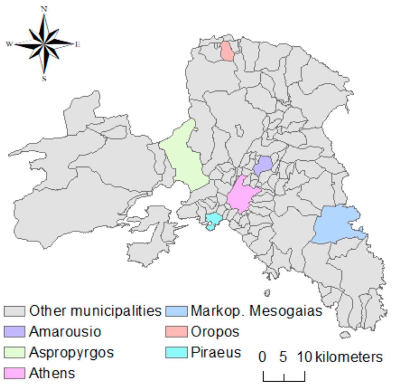
2.1. Study Area
2.2. Statistical Indicators
2.3. Data Analysis
3. Results
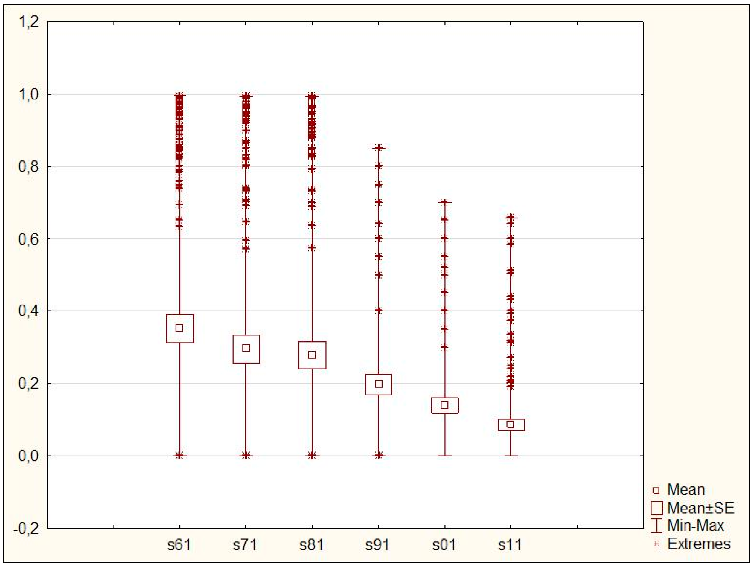
3.1. Descriptive Analysis of Sparse Settlements in Attica
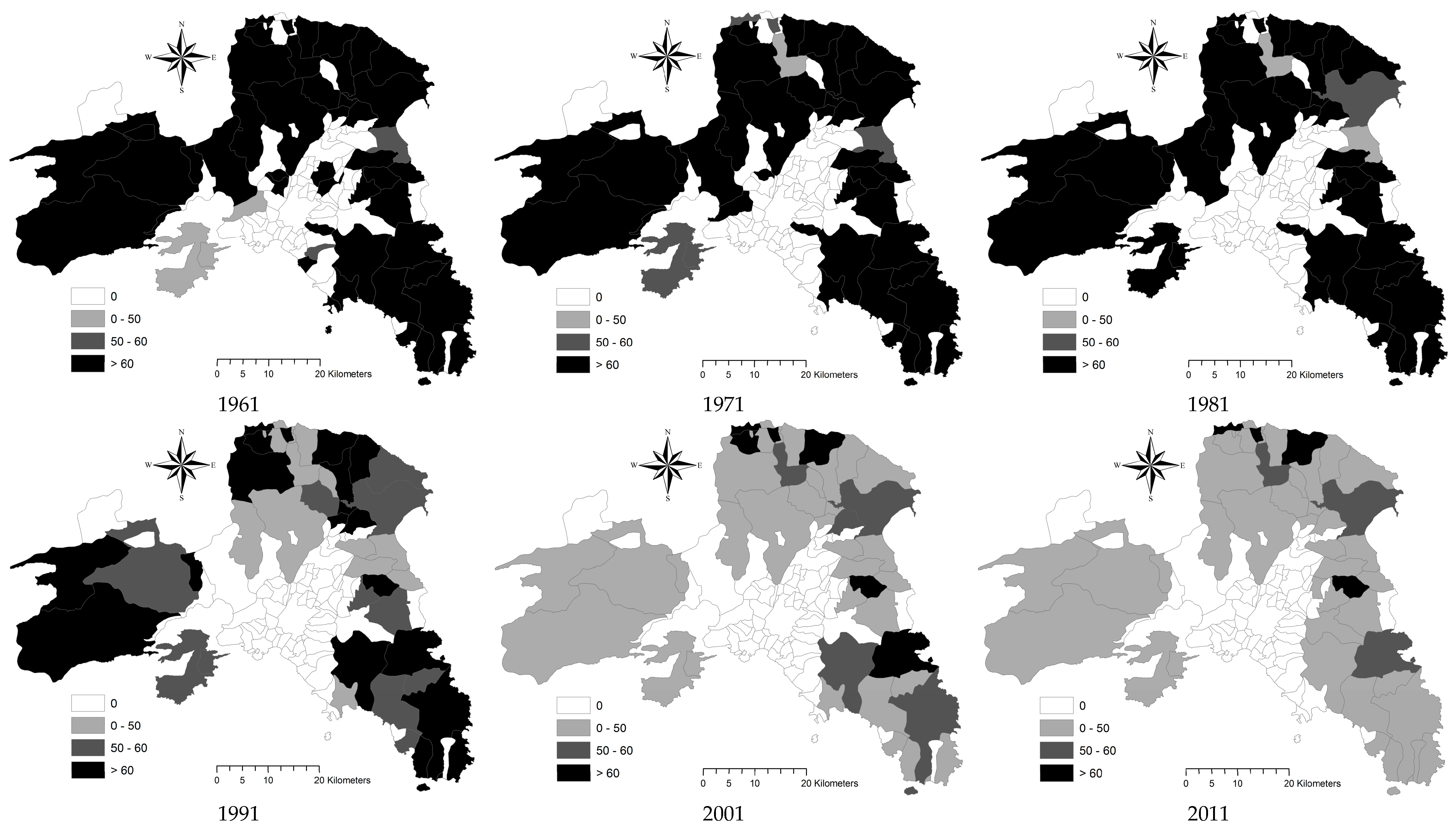
3.2. Spatial Distribution of Sparse Population in Attica
3.3. A Step-Wise Regression of Socioeconomic Predictors of Sparse Population in Attica
4. Discussion
5. Conclusions
Author Contributions
Funding
Conflicts of Interest
References
- Cecchini, M.; Zambon, I.; Pontrandolfi, A.; Turco, R.; Colantoni, A.; Mavrakis, A.; Salvati, L. Urban sprawl and the ‘olive’landscape: Sustainable land management for ‘crisis’ cities. GeoJournal 2018, 1–19. [Google Scholar] [CrossRef]
- Colantoni, A.; Delfanti, L.; Recanatesi, F.; Tolli, M.; Lord, R. Land use planning for utilizing biomass residues in Tuscia Romana (central Italy): Preliminary results of a multi criteria analysis to create an agro-energy district. Land Use Policy 2016, 50, 125–133. [Google Scholar] [CrossRef]
- Salvati, L. Agro-forest landscape and the ‘fringe’city: A multivariate assessment of land-use changes in a sprawling region and implications for planning. Sci. Total. Environ. 2014, 490, 715–723. [Google Scholar] [CrossRef] [PubMed]
- Salvati, L. From Sprawl to Compactness and Back: Long-term Population Dynamics (1848–2011) and the Economic Structure of a Mediterranean city. GeoJournal 2016, 81, 319–332. [Google Scholar] [CrossRef]
- Salvati, L.; Ferrara, C. Do changes in vegetation quality precede urban sprawl? Area 2013, 45, 365–375. [Google Scholar] [CrossRef]
- Salvati, L.; Zitti, M.; Sateriano, A. Changes in city vertical profile as an indicator of sprawl: Evidence from a Mediterranean urban region. Habitat Int. 2013, 38, 119–125. [Google Scholar] [CrossRef]
- Zambon, I.; Sauri, D.; Serra, P.; Carlucci, M.; Salvati, L. Beyond the ‘Mediterranean city’: Socioeconomic disparities and urban sprawl in three Southern European cities. Geogr. Ann. Ser. B Hum. Geogr. 2017, 99, 319–337. [Google Scholar] [CrossRef]
- Duvernoy, I.; Zambon, I.; Sateriano, A.; Salvati, L. Pictures from the Other Side of the Fringe: Urban Growth and Peri-urban Agriculture in a Post-industrial City (Toulouse, France). J. Rural. Stud. 2018, 57, 25–35. [Google Scholar] [CrossRef]
- Ferrara, A.; Salvati, L.; Sateriano, A.; Carlucci, M.; Gitas, I.; Biasi, R. Unraveling the “stable” landscape: A multi-factor analysis of unchanged agricultural and forest land (1987–2007) in a rapidly-expanding urban region. Urban Ecosyst. 2016, 19, 835–848. [Google Scholar] [CrossRef]
- Gkartzios, M.; Remoundou, K.; Garrod, G. Emerging geographies of mobility: The role of regional towns in Greece’s ‘counterurbanisation story’. J. Rural. Stud. 2017, 55, 22–32. [Google Scholar] [CrossRef]
- Gospodini, A. Portraying, classifying and understanding the emerging landscapes in the post-industrial city. Cities 2006, 23, 311–330. [Google Scholar] [CrossRef]
- Kizos, T.; Vakoufaris, H. Valorisation of local asset: The case of olive oil on Lesvos Island, Greece. Food Policy 2011, 36, 705–714. [Google Scholar] [CrossRef]
- Kristensen, S.P.; Thenail, C.; Kristensen, L. Farmers’ involvement in landscape: An analysis of the relationship between farm location, farm characteristics and landscape changes in two study areas in Jutlund, Denmark. J. Environ. Manag. 2001, 61, 301–318. [Google Scholar] [CrossRef] [PubMed]
- Makhzoumi, J.M. The changing role of rural landscapes: Olive and carob multi-use tree plantations in the semiarid Mediterranean. Landsc. Urban Plan. 1997, 37, 115–122. [Google Scholar] [CrossRef]
- Sabbi, A.; Salvati, L. Seeking for a Downward Spiral? Soil Erosion Risk, Agro-forest landscape and Socioeconomic Conditions in Italian local communities. Land Use Policy 2015, 41, 388–396. [Google Scholar] [CrossRef]
- Salvati, L.; Ferrara, A. Do land cover changes shape sensitivity to forest fires in peri-urban areas? Urban For. Urban Green. 2014, 13, 571–575. [Google Scholar] [CrossRef]
- Salvati, L.; Gasparella, L.; Munafò, M.M.; Romano, R.; Barbati, A. Figuring the features of the Roman Campagna: Recent landscape structural transformations of Rome’s countryside. Ann. Silvic. Res. 2017, 41, 20–28. [Google Scholar]
- Serra, P.; Pons, X.; Saurì, D. Land-cover and land-use change in a Mediterranean landscape: A spatial analysis of driving forces integrating biophysical and human factors. Appl. Geogr. 2008, 28, 189–209. [Google Scholar] [CrossRef]
- Colantoni, A.; Mavrakis, A.; Sorgi, T.; Salvati, L. Towards a ‘polycentric’ landscape? Reconnecting fragments into an integrated network of coastal forests in Rome. Rendiconti Accademia Nazionale dei Lincei 2015, 26, 615–624. [Google Scholar] [CrossRef]
- Estel, S.; Kuemmerle, T.; Alcántara, C.; Levers, C.; Prishchepov, A.; Hostert, P. Mapping farmland abandonment and recultivation across Europe using MODIS NDVI time series. Remote. Sens. Environ. 2015, 163, 312–325. [Google Scholar] [CrossRef]
- Kizos, T. Multifunctionality of farm households in Greece. Nor. Geogr. Tidsskr. Nor. J. Geogr. 2010, 64, 105–116. [Google Scholar] [CrossRef]
- Kizos, T.; Vasdeki, M.; Chatzikiriakou, C.; Dimitriou, D. ‘For my children’: Different functions of the agricultural landscape and attitudes of farmers on different areas of Greece towards small scale landscape change. Geogr. Tidsskr. Dan. J. Geogr. 2011, 111, 117–130. [Google Scholar] [CrossRef]
- Zambon, I.; Ferrara, A.; Salvia, R.; Mosconi, E.M.; Fici, L.; Turco, R.; Salvati, L. Rural Districts between Urbanization and Land Abandonment: Undermining Long-Term Changes in Mediterranean Landscapes. Sustainability 2018, 10, 1159. [Google Scholar] [CrossRef]
- Baró, F.; Palomo, I.; Zulian, G.; Vizcaino, P.; Haase, D.; Gómez-Baggethun, E. Mapping ecosystem service capacity, flow and demand for landscape and urban planning: A case study in the Barcelona metropolitan region. Land Use Policy 2016, 57, 405–417. [Google Scholar] [CrossRef]
- Ceccarelli, T.; Bajocco, S.; Perini, L.; Salvati, L. Urbanisation and Land Take of High Quality Agricultural Soils—Exploring Long-term Land Use Changes and Land Capability in Northern Italy. Int. J. Environ. Res. 2014, 8, 181–192. [Google Scholar]
- Salvati, L.; Ferrara, A.; Tombolini, I.; Gemmiti, R.; Colantoni, A.; Perini, L. Desperately Seeking Sustainability: Urban Shrinkage, Land Consumption and Regional Planning in a Mediterranean Metropolitan Area. Sustainability 2015, 7, 11980–11997. [Google Scholar] [CrossRef]
- Colantoni, A.; Ferrara, C.; Perini, L.; Salvati, L. Assessing Trends in Climate Aridity and Vulnerability to Soil Degradation in Italy. Ecol. Indic. 2015, 48, 599–604. [Google Scholar] [CrossRef]
- Colantoni, A.; Grigoriadis, E.; Sateriano, A.; Venanzoni, G.; Salvati, L. Cities as selective land predators? A lesson on urban growth, deregulated planning and sprawl containment. Sci. Total. Environ. 2016, 545, 329–339. [Google Scholar] [CrossRef] [PubMed]
- Colantoni, A.; Grigoriadis, E.; Sateriano, A.; Sarantakou, E.; Salvati, L. Back to Von Thunen: A Southern European perspective on mono-centric urban growth, economic structure and non-urban land decline. Int. Plan. Stud. 2017, 22, 173–188. [Google Scholar] [CrossRef]
- Tanrivermis, H. Agricultural land use change and sustainable use of land resources in the Mediterranean region of Turkey. J. Arid. Environ. 2003, 54, 553–564. [Google Scholar] [CrossRef]
- Zambon, I.; Colantoni, A.; Carlucci, M.; Morrow, N.; Sateriano, A.; Salvati, L. Land quality, sustainable development and environmental degradation in agricultural districts: A computational approach based on entropy indexes. Environ. Impact Assess. Rev. 2017, 64, 37–46. [Google Scholar] [CrossRef]
- Garcia Latorre, J.; Garcia-Latorre, J.; Sanchez-Picon, A. Dealing with aridity: Socio-economic structures and environmental changes in an arid Mediterranean region. Land Use Policy 2001, 18, 53–64. [Google Scholar] [CrossRef]
- Schneider, A.; Woodcock, C.E. Compact, dispersed, fragmented, extensive? A comparison of urban growth in twenty-five global cities using remotely sensed data, pattern metrics and census information. Urban Stud. 2008, 45, 659–692. [Google Scholar] [CrossRef]
- Salvati, L.; Tombolini, I.; Gemmiti, R.; Carlucci, M.; Bajocco, S.; Perini, L.; Ferrara, A.; Colantoni, A. Complexity in action: Untangling latent relationships between land quality, economic structures and socio-spatial patterns in Italy. PLoS ONE 2015, 12, e0177853. [Google Scholar] [CrossRef] [PubMed]
- Salvati, L. Urban expansion and high-quality soil consumption—An inevitable spiral? Cities 2013, 31, 349–356. [Google Scholar] [CrossRef]
- Pereira, P.; Brevik, E.C.; Muñoz-Rojas, M.; Miller, B.A.; Smetanova, A.; Depellegrin, D.; Misiune, I.; Novara, A.; Cerdà, A. Chapter 2—Soil Mapping and Processes Modeling for Sustainable Land Management. Soil Map. Process Model. Sustain. Land Use Manag. 2017, 29–60. [Google Scholar] [CrossRef]
- Salvati, L.; Bajocco, S.; Ceccarelli, T.; Zitti, M.; Perini, L. Towards a process-based evaluation of soil vulnerability to degradation: A spatio-temporal approach in Italy. Ecol. Indic. 2011, 11, 1216–1227. [Google Scholar] [CrossRef]
- Mavrakis, A.; Colantoni, A.; Salvati, L. Soil degradation, landscape and climate variations in a Mediterranean agro-forest system (Thriasio, Greece): Proposal for a desertification indicator using time series analysis. Int. J. Agric. Resour. Gov. Ecol. 2014, 10, 335–343. [Google Scholar] [CrossRef]
- Zambon, I.; Benedetti, A.; Ferrara, C.; Salvati, L. Soil Matters? A Multivariate Analysis of Socioeconomic Constraints to Urban Expansion in Mediterranean Europe. Ecol. Econ. 2018, 146, 173–183. [Google Scholar] [CrossRef]
- Hall, P. The future of the metropolis and its form. Reg. Stud. 1997, 31, 211–220. [Google Scholar] [CrossRef]
- Parr, J. The Regional Economy, Spatial Structure and Regional Urban Systems. Reg. Stud. 2014, 48, 1926–1938. [Google Scholar] [CrossRef]
- Salvati, L.; Serra, P. Estimating rapidity of change in complex urban systems: A multidimensional, local-scale approach. Geogr. Anal. 2016, 48, 132–156. [Google Scholar] [CrossRef]
- Arapoglou, V.P.; Sayas, J. New facets of urban segregation in Southern Europe. Eur. Urban Reg. Stud. 2009, 16, 345–362. [Google Scholar] [CrossRef]
- Di Feliciantonio, C.; Salvati, L. ‘Southern’ alternatives of urban diffusion: Investigating settlement characteristics and socioeconomic patterns in three Mediterranean regions. Tijdschr. Econ. Soc. Geogr. 2015, 106, 453–470. [Google Scholar] [CrossRef]
- Maloutas, T. Segregation and residential mobility: Spatially entrapped social mobility and its impact on segregation in Athens. Eur. Urban Reg. Stud. 2004, 11, 195–211. [Google Scholar] [CrossRef]
- Carlucci, M.; Grigoriadis, E.; Rontos, K.; Salvati, L. Revisiting an Hegemonic Concept: Long-term ‘Mediterranean Urbanization’ in between city re-polarization and metropolitan decline. Appl. Spat. Anal. Policy 2017, 10, 347–362. [Google Scholar] [CrossRef]
- Chorianopoulos, I.; Pagonis, T.; Koukoulas, S.; Drymoniti, S. Planning, competitiveness and sprawl in the Mediterranean city: The case of Athens. Cities 2010, 27, 249–259. [Google Scholar] [CrossRef]
- Chorianopoulos, I.; Tsilimigkas, G.; Koukoulas, S.; Balatsos, T. The shift to competitiveness and a new phase of sprawl in the Mediterranean city: Enterprises guiding growth in Messoghia—Athens. Cities 2014, 39, 133–143. [Google Scholar] [CrossRef]
- Gkartzios, M. ‘Leaving Athens’: Narratives of counterurbanisation in times of crisis. J. Rural. Stud. 2013, 32, 158–167. [Google Scholar] [CrossRef]
- Rontos, K.; Grigoriadis, E.; Sateriano, A.; Syrmali, M.; Vavouras, I.; Salvati, L. Lost in protest, found in segregation: Divided cities in the light of the 2015 “Oχι” referendum in Greece. City Cult. Soc. 2016, 7, 139–148. [Google Scholar] [CrossRef]
- Souliotis, N. Cultural economy, sovereign debt crisis and the importance of local contexts: The case of Athens. Cities 2013, 33, 61–68. [Google Scholar] [CrossRef]
- Zitti, M.; Ferrara, C.; Perini, L.; Carlucci, M.; Salvati, L. Long-term urban growth and land use efficiency in Southern Europe: Implications for sustainable land management. Sustainability 2015, 7, 3359–3385. [Google Scholar] [CrossRef]
- Ferrara, C.; Carlucci, M.; Grigoriadis, E.; Corona, P.; Salvati, L. A comprehensive insight into the geography of forest cover in Italy: Exploring the importance of socioeconomic local contexts. For. Policy Econ. 2017, 75, 12–22. [Google Scholar] [CrossRef]
- Rontos, K.; Zitti, M.; Salvati, L. Past, Present and Future: Expansion with (and without) growth in urban systems under a structural crisis. Theor. Empir. Res. Urban Manag. 2017, 12, 16–31. [Google Scholar]
- Gkartzios, M.; Remoundou, K. Language struggles: Representations of the countryside and the city in an era of mobilities. Geoforum 2018, 93, 1–10. [Google Scholar] [CrossRef]
- Bell, M.M.; Osti, G. Mobilities and ruralities: An introduction. Sociol. Rural. 2010, 50, 199–204. [Google Scholar] [CrossRef]
- Stockdale, A. Contemporary and ‘messy’rural in-migration processes: Comparing counterurban and lateral rural migration. Popul. Space Place 2016, 22, 599–616. [Google Scholar] [CrossRef]
- Milbourne, P. Re-populating rural studies: Migrations, movements and mobilities. J. Rural Stud. 2007, 23, 381–386. [Google Scholar] [CrossRef]
- Benson, M.; O’reilly, K. Migration and the search for a better way of life: A critical exploration of lifestyle migration. Sociol. Rev. 2009, 57, 608–625. [Google Scholar] [CrossRef]
- Gkartzios, M.; Scott, K. A Cultural Panic in the Province? Counterurban Mobilities, Creativity, and Crisis in Greece. Popul. Space Place 2015, 21, 843–855. [Google Scholar] [CrossRef]
- Murdoch, J.; Lowe, P.; Ward, N. The Differentiated Countryside; Routledge: Abingdon, UK, 2003. [Google Scholar]
- Gkartzios, M.; Scott, M. Placing housing in rural development: Exogenous, endogenous and neo-endogenous approaches. Sociol. Rural. 2014, 54, 241–265. [Google Scholar] [CrossRef]
- Gargiulo Morelli, V.; Rontos, K.; Salvati, L. Between suburbanisation and re-urbanisation? Revisiting the Urban Life Cycle in a Mediterranean Compact City. Urban Res. Pract. 2014, 7, 74–88. [Google Scholar] [CrossRef]
- Kallis, G. Co-evolution in water resource development. The vicious cycle of water supply and demand in Athens, Greece. Ecol. Econ. 2010, 69, 796–809. [Google Scholar] [CrossRef]
- De Rosa, S.; Salvati, L. Beyond a ‘side street story’? Naples from spontaneous centrality to entropic polycentricism, towards a ‘crisis city’. Cities 2016, 51, 74–83. [Google Scholar] [CrossRef]
- Kaika, M. The economic crisis seen from the everyday. City 2012, 16, 422–430. [Google Scholar] [CrossRef]
- Remoundou, K.; Gkartzios, M.; Garrod, G. Conceptualizing mobility in times of crisis: Towards crisis-led counterurbanization? Reg. Stud. 2016, 50, 1663–1674. [Google Scholar] [CrossRef]
- Moissidis, A.; Duquenne, M.-N. Peri-urban rural areas in Greece: The case of Attica. Sociol. Rural. 1997, 37, 228–239. [Google Scholar] [CrossRef]
- Aretano, R.; Petrosillo, I.; Zaccarelli, N.; Semeraro, T.; Zurlini, G. People perception of landscape change effects on ecosystem services in small Mediterranean islands: A combination of subjective and objective assessments. Landsc. Urban Plan. 2013, 112, 63–73. [Google Scholar] [CrossRef]
- Beriatos, E.; Gospodini, A. Glocalising urban landscapes: Athens and the 2004 Olympics. Cities 2004, 21, 187–202. [Google Scholar] [CrossRef]
- Biasi, R.; Colantoni, A.; Ferrara, C.; Ranalli, F.; Salvati, L. In-between Sprawl and Fires: Long-term Forest Expansion and Settlement Dynamics at the Wildland-Urban Interface in Rome, Italy. Int. J. Sustain. Dev. World Ecol. 2015, 22, 467–475. [Google Scholar] [CrossRef]
- Cimini, D.; Tomao, A.; Mattioli, W.; Barbati, A.; Corona, P. Assessing impact of forest cover change dynamics on high nature value farmland in Mediterranean mountain landscape. Ann. Silvic. Res. 2013, 37, 29–37. [Google Scholar]
- Cohen, M.; Bilodeau, C.; Alexandre, F.; Godron, M.; Andrieu, J.; Gresillon, E.; Garlatti, F.; Morganti, A. What is the plant biodiversity in a cultural landscape? A comparative, multi-scale and interdisciplinary study in olive groves and vineyards (Mediterranean France). Agric. Ecosyst. Environ. 2015, 212, 175–186. [Google Scholar] [CrossRef]
- Economidou, E. The Attic landscape throughout the centuries and its human degradation. Landsc. Urban Plan. 1993, 24, 33–37. [Google Scholar] [CrossRef]
- Raudsepp-Hearne, C.; Peterson, G.D.; Bennett, E.M. Ecosystem service bundles for analyzing tradeoffs in diverse landscapes. Proc. Natl. Acad. Sci. USA. 2010, 107, 5242–5247. [Google Scholar] [CrossRef] [PubMed]
- Salvati, L.; Zitti, M.; Carlucci, M. ‘Locked’ systems, territorial disparities and sustainability: Economic structure and soil degradation in Italy. Sustainability 2014, 6, 3086–3104. [Google Scholar] [CrossRef]
- Tsilimigkas, G.; Kizos, T. Space, pressures and the management of the Greek landscape. Geogr. Ann. Ser. B Hum. Geogr. 2014, 96, 159–175. [Google Scholar] [CrossRef]
- Vieri, M. Traditional olive crop mechanization in areas with a high landscape value. Results of tests with new olive picking equipment. Adv. Hortic. Sci. 2002, 16, 235–239. [Google Scholar]
- Zambon, I.; Colantoni, A.; Cecchini, M.; Mosconi, E.M. Rethinking sustainability within the viticulture realities integrating economy, landscape and energy. Sustainability 2018, 10, 320. [Google Scholar] [CrossRef]
- Barbati, A.; Corona, P.; Salvati, L.; Gasparella, L. Natural forest expansion into suburban countryside: Gained ground for a green infrastructure? Urban For. Urban Green. 2013, 12, 36–43. [Google Scholar] [CrossRef]
- Orsini, S. Landscape polarisation, hobby farmers and valuable hills in Tuscany: Understanding landscape dynamics in a peri-urban context. Geogr. Tidsskr. Dan. J. Geogr. 2013, 113, 54–64. [Google Scholar] [CrossRef]
- Delladetsima, P.M. The emerging property development pattern in Greece and its impact on spatial development. Eur. Urban Reg. Stud. 2006, 13, 245–278. [Google Scholar] [CrossRef]
- Giannakourou, G. Planning regulation, property protection, and regulatory takings in the Greek planning law. Wash. Univ. Glob. Stud. Law Rev. 2006, 5, 534–557. [Google Scholar]
- Cuadrado-Ciuraneta, S.; Durà-Guimerà, A.; Salvati, L. Not only tourism: Unravelling suburbanization, second-home expansion and “rural” sprawl in Catalonia, Spain. Urban Geogr. 2017, 38, 66–89. [Google Scholar] [CrossRef]
- Fregolent, L.; Vettoretto, L. Land use regulation and social regulation: An unexplored link. Some reflections on the origins and evolution of sprawl in the Veneto “città diffusa”. Land Use Policy 2017, 69, 149–159. [Google Scholar] [CrossRef]
- Boubaker, K.; Colantoni, A.; Marucci, A.; Longo, L.; Gambella, F.; Cividino, S.; Cecchini, M. Perspective and potential of CO2: A focus on potentials for renewable energy conversion in the Mediterranean basin. Renew. Energy 2016, 90, 248–256. [Google Scholar] [CrossRef]
- Delfanti, L.; Colantoni, A.; Recanatesi, F.; Bencardino, M.; Sateriano, A.; Zambon, I.; Salvati, L. Solar plants, environmental degradation and local socioeconomic contexts: A case study in a Mediterranean country. Environ. Impact Assess. Rev. 2016, 61, 88–93. [Google Scholar] [CrossRef]
- Colantoni, A.; Allegrini, E.; Boubaker, K.; Longo, L.; Di Giacinto, S.; Biondi, P. New insights for renewable energy hybrid photovoltaic/wind installations in Tunisia through a mathematical model. Energy Convers. Manag. 2013, 75, 398–401. [Google Scholar] [CrossRef]
- Monarca, D.; Cecchini, M.; Guerrieri, M.; Colantoni, A. Conventional and alternative use of biomasses derived by hazelnut cultivation and processing. In Proceedings of the VII International Congress on Hazelnut, Viterbo, Italy, 23–27 June 2008; Volume 845, pp. 627–634. [Google Scholar]
- Di Felice, V.; Bessa, E.R.D.J.S.; Mancinelli, R.; Batista, J.G.F.; Campiglia, E. Rurality and agroecosystem sustainability: A case study at farm-field level in Terceira Island (Portugal) and in Viterbo Province (Italy). Renew. Agric. Food Syst. 2014, 29, 265–276. [Google Scholar] [CrossRef]
- Ferrara, A.; Salvati, L.; Sabbi, A.; Colantoni, A. Urbanization, Soil Quality and Rural Areas: Towards a Spatial Mismatch? Sci. Total. Environ. 2014, 478, 116–122. [Google Scholar] [CrossRef] [PubMed]
- Monarca, D.; Cecchini, M.; Colantoni, A.; Marucci, A. Feasibility of the electric energy production through gasification processes of biomass: Technical and economic aspects. In Proceedings of the International Conference on Computational Science and Its Applications, San Francisco, CA, USA, 19–21 October 2011; Springer: Berlin/Heidelberg, Germany, 2011; pp. 307–315. [Google Scholar]
- Colantoni, A.; Marucci, A.; Monarca, D.; Pagniello, B.; Cecchini, M.; Bedini, R. The risk of musculoskeletal disorders due to repetitive movements of upper limbs for workers employed to vegetable grafting. J. Food Agric. Environ. 2012, 10, 14–18. [Google Scholar]
- Giourga, C.; Loumou, A. Assessing the impact of pluriactivity on sustainable agriculture. A case study in rural areas of Beotia in Greece. Environ. Manag. 2006, 37, 753–763. [Google Scholar] [CrossRef] [PubMed]
- Marchetti, M.; Vizzarri, M.; Lasserre, B.; Sallustio, L.; Tavone, A. Natural capital and bioeconomy: Challenges and opportunities for forestry. Ann. Silvic. Res. 2015, 38, 62–73. [Google Scholar]
- Marucci, A.; Zambon, I.; Colantoni, A.; Monarca, D. A combination of agricultural and energy purposes: Evaluation of a prototype of photovoltaic greenhouse tunnel. Renew. Sustain. Energy Rev. 2018, 82, 1178–1186. [Google Scholar] [CrossRef]
- Nuissl, H.; Haase, D.; Lanzendorf, M.; Wittmer, H. Environmental impact assessment of urban land use transitions—A context-sensitive approach. Land Use Policy 2009, 26, 414–424. [Google Scholar] [CrossRef]
- Pili, S.; Grigoriadis, E.; Carlucci, M.; Clemente, M.; Salvati, L. Towards Sustainable Growth? A Multi-criteria Assessment of (Changing) Urban Forms. Ecol. Indic. 2017, 76, 71–80. [Google Scholar] [CrossRef]
- Salvati, L.; Carlucci, M. The economic and environmental performances of rural districts in Italy: Are competitiveness and sustainability compatible targets? Ecol. Econ. 2011, 70, 2446–2453. [Google Scholar] [CrossRef]
- Zambon, I.; Monarca, D.; Cecchini, M.; Bedini, R.; Longo, L.; Romagnoli, M.; Marucci, A. Alternative energy and the development of local rural contexts: An approach to improve the degree of smart cities in the Central-Southern Italy. Contemp. Eng. Sci 2016, 9, 1371–1386. [Google Scholar] [CrossRef]
- Zambon, I.; Colantoni, A.; Monarca, D.; Cecchini, M.; Salvati, L. Characterizing Population Dynamics And Early Processes of Urbanization in Rural Tuscia, Central Italy. Rom. J. Reg. Sci. 2017, 11, 76–101. [Google Scholar]
- Monarca, D.; Cecchini, M.; Colantoni, A. Plant for the production of chips and pellet: Technical and economic aspects of an case study in the central Italy. In International Conference on Computational Science and Its Applications (ICCSA 2011); Springer: Berlin/Heidelberg, Germany, 2011; pp. 296–306. [Google Scholar]
- Corona, P. Forestry research to support the transition towards a bio-based economy. Ann. Silvic. Res. 2015, 38, 37–38. [Google Scholar]
- Salvati, L. Neither Ordinary nor Global: A Reflection on the ‘Extra-ordinary’ Expansion of Athens. Urban Plan. Transp. Res. 2014, 2, 49–56. [Google Scholar] [CrossRef]
- Giannakourou, G. Transforming spatial planning policy in Mediterranean countries: Europeanization and domestic change. Eur. Plan. Stud. 2005, 13, 319–331. [Google Scholar] [CrossRef]
- Tsilimigkas, G.; Stathakis, D.; Pafi, M. Evaluating the land use patterns of medium-sized Hellenic cities. Urban Res. Pract. 2015, 9, 181–203. [Google Scholar] [CrossRef]
- Kizos, T.; Tsilimigkas, G.; Karampela, S. What Drives Built-Up Area Expansion on Islands? Using Soil Sealing Indicators to Estimate Built-Up Area Patterns on Aegean Islands, Greece. Tijdschr. Econ. Soc. Geogr. 2017, 12, 35–52. [Google Scholar] [CrossRef]
- Amato, F.; Maimone, B.A.; Martellozzo, F.; Nolè, G.; Murgante, B. The Effects of Urban Policies on the Development of Urban Areas. Sustainability 2016, 8, 297. [Google Scholar] [CrossRef]
- Amato, F.; Tonini, M.; Murgante, B.; Kanevski, M. Fuzzy definition of Rural Urban Interface: An application based on land use change scenarios in Portugal. Environ. Model. Softw. 2018, 104, 171–187. [Google Scholar] [CrossRef]
- Aubry, R.J.; Abat, M.-H.; Ramamonjisoa, J.; Dabat, M.H.; Rakotoarisoa, J.; Rakotondraibe, J.; Rabeharisoa, L. Urban agriculture and land use in cities: An approach with multi-functionality and sustainsability concepts in the case of Antananarivo (Madagascar). Land Use Policy 2012, 29, 429–439. [Google Scholar] [CrossRef]
- Audsley, E.; Pearn, K.R.; Simota, C.; Cojocaru, G.; Koutsidou, E.; Rounsevell, M.D.A.; Trnka, M.; Alexandrov, V. What can scenario modelling tell us aboutfuture European scale agricultural land use and what not? Environ. Sci. Policy 2006, 9, 148–162. [Google Scholar] [CrossRef]
- Biasi, R.; Brunori, E.; Smiraglia, D.; Salvati, L. Linking traditional tree-crop landscapes and agro-biodiversity in Central Italy using a database of typical and traditional products: A multiple risk assessment through a data mining analysis. Biodivers. Conserv. 2015, 24, 3009–3031. [Google Scholar] [CrossRef]
- Kelly, C.; Ferrara, A.; Wilson, G.A.; Ripullone, F.; Nolè, A.; Harmer, N.; Salvati, L. Community resilience and land degradation in forest and shrubland socio-ecological systems: Evidence in Gorgoglione, Basilicata, Italy. Land Use Policy 2015, 46, 11–20. [Google Scholar] [CrossRef]
- Mosquera-Losada, M.R.; Santiago Freijanes, J.J.; Pisanelli, A.; Rois, M.; Smith, J.; den Herder, M.; Ferreiro Domínguez, N. Extent and Success of Current Policy Measures to Promote Agroforestry Across Europe; AGFORWARD European Project Policy Report: Bruxelles, Belgium, 2016. [Google Scholar]
- Paul, V.; Haslam Mckenzie, F. Peri-urban farmland conservation and development of alternative food networks: Insights from a case study area in metropolitan Barcelona (Catalonia, Spain). Land Use Policy 2013, 30, 94–105. [Google Scholar] [CrossRef]
- Serra, P.; Vera, A.; Tulla, A.F.; Salvati, L. Beyond urban-rural dichotomy: Exploring socioeconomic and land-use processes of change in Spain (1991–2011). Appl. Geogr. 2014, 55, 71–81. [Google Scholar] [CrossRef]


| Variab. | 1961 | 1971 | 1981 | |||||||||
| B | SE | t(108) | p | B | SE | t(110) | p | B | SE | t(110) | p | |
| dAth | 0.905 | 0.236 | 3.84 | 0.0002 ** | 1.056 | 0.231 | 4.56 | 0.0000 ** | 0.998 | 0.225 | 4.44 | 0.0000 ** |
| Area | 0.332 | 0.081 | 4.12 | 0.0001 ** | 0.339 | 0.080 | 4.23 | 0.0000 ** | 0.390 | 0.078 | 5.00 | 0.0000 ** |
| dMak | −0.620 | 0.187 | −3.31 | 0.0013 * | −0.632 | 0.186 | −3.39 | 0.0010 * | −0.630 | 0.181 | −3.48 | 0.0007 ** |
| dAsp | −0.483 | 0.207 | −2.33 | 0.0215 * | −0.531 | 0.206 | −2.58 | 0.0112 * | −0.478 | 0.200 | −2.39 | 0.0186 * |
| t | 0.190 | 0.070 | 2.71 | 0.0079* | ||||||||
| Afs | 0.190 | 0.082 | 2.31 | 0.0226 * | ||||||||
| Adj-R2 | 0.454 | 0.455 | 0.486 | |||||||||
| DW test* | 1.90 | 1.98 | 1.91 | |||||||||
| 1991 | 2001 | 2011 | ||||||||||
| B | SE | t(110) | p | B | SE | t(110) | p | B | SE | t(108) | p | |
| dAth | 0.663 | 0.081 | 8.18 | 0.0000 ** | ||||||||
| Area | 0.362 | 0.076 | 4.75 | 0.0000 ** | 0.318 | 0.073 | 4.34 | 0.0000 ** | 0.412 | 0.107 | 3.85 | 0.0002 ** |
| dMak | −0.368 | 0.089 | −4.15 | 0.0001 ** | −0.740 | 0.109 | −6.76 | 0.0000 ** | −0.358 | 0.203 | −1.77 | 0.0800 * |
| dAsp | 0.307 | 0.149 | 2.06 | 0.0414 * | ||||||||
| dOro | −0.189 | 0.077 | −2.47 | 0.0149 * | −0.758 | 0.100 | −7.58 | 0.0000 ** | −0.734 | 0.123 | −5.98 | 0.0000 ** |
| dMar | 1.000 | 0.106 | 9.39 | 0.0000 ** | 0.566 | 0.218 | 2.60 | 0.0107 * | ||||
| Ele | −0.275 | 0.099 | −2.78 | 0.0063 * | ||||||||
| Adj-R2 | 0.535 | 0.548 | 0.509 | |||||||||
| DW test* | 1.96 | 1.97 | 1.96 | |||||||||
© 2018 by the authors. Licensee MDPI, Basel, Switzerland. This article is an open access article distributed under the terms and conditions of the Creative Commons Attribution (CC BY) license (http://creativecommons.org/licenses/by/4.0/).
Share and Cite
Salvia, R.; Serra, P.; Zambon, I.; Cecchini, M.; Salvati, L. In-Between Sprawl and Neo-Rurality: Sparse Settlements and the Evolution of Socio-Demographic Local Context in a Mediterranean Region. Sustainability 2018, 10, 3670. https://doi.org/10.3390/su10103670
Salvia R, Serra P, Zambon I, Cecchini M, Salvati L. In-Between Sprawl and Neo-Rurality: Sparse Settlements and the Evolution of Socio-Demographic Local Context in a Mediterranean Region. Sustainability. 2018; 10(10):3670. https://doi.org/10.3390/su10103670
Chicago/Turabian StyleSalvia, Rosanna, Pere Serra, Ilaria Zambon, Massimo Cecchini, and Luca Salvati. 2018. "In-Between Sprawl and Neo-Rurality: Sparse Settlements and the Evolution of Socio-Demographic Local Context in a Mediterranean Region" Sustainability 10, no. 10: 3670. https://doi.org/10.3390/su10103670
APA StyleSalvia, R., Serra, P., Zambon, I., Cecchini, M., & Salvati, L. (2018). In-Between Sprawl and Neo-Rurality: Sparse Settlements and the Evolution of Socio-Demographic Local Context in a Mediterranean Region. Sustainability, 10(10), 3670. https://doi.org/10.3390/su10103670