Article

The Use of Big Data in Regenerative Planning

by
Dorota Kamrowska-Zaluska
* and
Hanna Obracht-Prondzyńska
*
Department of Urban Design and Regional Planning, Gdansk University of Technology, 80-384 Gdansk, Poland
*
Authors to whom correspondence should be addressed.
Sustainability 2018, 10(10), 3668; https://doi.org/10.3390/su10103668
Submission received: 9 August 2018 / Revised: 7 October 2018 / Accepted: 11 October 2018 / Published: 13 October 2018
(This article belongs to the Special Issue Transition towards Low-Impact and Regenerative Human Settlements)

Abstract

:
With the increasing significance of Big Data sources and their reliability for studying current urban development processes, new possibilities have appeared for analyzing the urban planning of contemporary cities. At the same time, the new urban development paradigm related to regenerative sustainability requires a new approach and hence a better understanding of the processes changing cities today, which will allow more efficient solutions to be designed and implemented. It results in the need to search for tools which will allow more advanced analyses while assessing the planning projects supporting regenerative development. Therefore, in this paper, the authors study the role of Big Data retrieved from sensor systems, social media, GPS, institutional data, or customer and transaction records. The study includes an enquiry into how Big Data relates to the ecosystem and to human activities, in supporting the development of regenerative human settlements. The aim of the study is to assess the possibilities created by Big Data-based tools in supporting regenerative design and planning and the role they can play in urban projects. In order to do this, frameworks allowing for the assessment of planning projects were analyzed according to their potential to support a regenerative approach. This has been followed by an analysis of the accessibility and reliability of the data sources. Finally, Big Data-based projects were mapped upon aspects of regenerative planning according to the introduced framework.

1. Introduction

The world is changing and technology influences the development of cities in many areas. Big Data is more and more present and can potentially be used to help in the planning of more sustainable human settlements. With rapidly developing new technologies and instruments based on Big Data, a large amount of information concerning social, economic, and spatial data is being collected in smart cities, including both the public realm and buildings [1], allowing a more accurate analysis of the processes shaping contemporary urban environments. With the possibilities resulting from the globalization and digitization of data, the range and precision of the analysis of urban structures is increasing. Open access to large datasets allows for a broader understanding of phenomena that determine the development of cities [2] and the way they influence urban ecosystems and their services as a direct contribution to human well-being, supporting the survival and quality of life of city dwellers [3,4]. At the same time, with the increasing functional and virtual connectivity of urban space, as well as the growing knowledge of the causes of climate change, numerous communities are adopting various smart and innovative solutions to strengthen the sustainability and resilience of cities [5].
In this paper, the authors inquire into the possibilities provided by Big Data-based tools in supporting regenerative design and planning, by seeking answers to the following questions:
  • Can Big Data, when used considering an eco-systemic approach, help in shaping policies and support the development of cities?
  • What is the potential of Big Data-based tools in supporting and assessing the regenerative design of urban spaces?
  • Under what conditions can Big Data be integrated into regenerative design and sustainable planning?
The methodological approach of the study is based on gap analysis identifying opportunities and barriers, which can possibly prevent or foster the use of Big Data to support the emerging regenerative sustainability paradigm. In the frame of the research, the evolution of frameworks for assessing sustainability and case studies focusing on the data sources, and scale of intervention, as well as the phase of the planning process, were analyzed. As a core of the study, a conceptual framework of the model for the use of Big Data in the regenerative planning projects was introduced, preceded by three phases of research (Figure 1). The first phase includes an analysis of already existing frameworks for assessing sustainability and the choice of the one most suitable for a regenerative approach to planning. Furthermore, some key elements, such as creating a positive balance and a holistic and circular approach, as well as assessing flows, were defined (phase 2). Moreover, the data sources which are used or could be potentially supportive and useful in this process were examined. This study, through the introduction of challenges appearing when implementing Big Data instruments in spatial analysis, allows for the evaluation of their usability and effectiveness for assessing regenerative planning projects including the aspect of reliability and accessibility of data. In this paper, the use of Big Data based tools in regenerative planning projects and their further verification in the context of changes in the regenerative paradigm is discussed. It concludes with recommendations for possible ways of using Big Data in regenerative design and planning (phase 3).
The paper is divided into nine main sections, starting from the introduction, which gives an outline of the study. In the second section, a literature review is introduced with a strong focus on state-of-the-art thinking on regenerative sustainability and the use of the Big Data-based tools. The next two parts include an outline of the research design, including the aim, objectives, conceptual framework of the study, and methodology. They are followed by a description of the evolution of frameworks for assessing sustainability. Further, a review of the processes and mechanisms for using Big Data in the built environment is conducted, while in section seven, the classification of data sources supporting regenerative planning is described. The core of this paper includes an introduction of the model of analysis to implement Big Data use in sustainable design and planning processes. Finally, the research ends with cognitive conclusions and implementation recommendations.
The aim of this paper is to analyze the possibilities given by the Big Data-based tools in order to support regenerative design and planning. Such solutions can play a vital role in assessing the development of regenerative features of urban settlements, while going beyond the “smart” approach to sustainability. The authors explore how Big Data, when related to the ecosystem and human activities, helps in shaping policies and evaluation tools to support the regenerative development of cities (objective 1). Thus, while studying successfully implemented initiatives, the authors analyze possible uses of Big Data in supporting the regenerative design of urban spaces (objective 2). At the same time, the authors try to define the necessary conditions which allow for the integration of Big Data-based tools with regenerative design and sustainable planning (objective 3).

2. Background—Regenerative Sustainability, Its Assessment, and the Opportunity to Use Big Data

In current strategies for enhancing sustainability in the built environment, ICT has been gaining prominence [6]. At the same time, the neo-functionalist narrative can still be observed very often, limiting this approach to matching energy demand and supply, enhancing the efficiency of the distribution systems, and nurturing the market for smart appliances [7]. Smart built environments already have multiple systems for capturing and monitoring data about human-ecosystem relations [8,9], such as mobility, environmental conditions, energy usage and efficiency, service quality, health, etc., although these systems are too often not integrated with one another [10]. On top of that, those data are seldom harmonized, meaning that they need to be processed to achieve similar standards, qualities, and ranges for them to be used together, to be compared, and to be used in the same calculations and statistical analyses [11].
Reliance on ICT solutions makes the narrative of smart buildings and smart cities proceed, beyond any evidence of failure [12], till the moment in which a shift to a more regenerative approach occurs. Although theoretical bases are established, in praxis, the assessment of a smart build environment is still often narrowed to technological aspects only. Therefore, there is a need to move from a narrow focus on building energy performance, mitigation strategies, and the minimization of environmental impacts, to a broader framework that enriches places, people, ecology, culture, and climate at the core of the restorative design call [13,14].
To support this shift, within this study, the question about ways of assessing the regenerative feature of settlements is being asked in terms of:
  • self-sufficiency in most aspects, leading to a judicious use of the local resources within the context of community lives;
  • the wide introduction of conservation technologies in areas of water, energy, and appropriate building materials (positive energy and material flows);
  • respecting natural conditions, avoiding loss of the natural landscape and most importantly, of all un-checked consumption, including fighting the urban sprawl (sustainable land use);
  • promoting the mixed-land use and multi-level use in urban areas to reduce the energy consumption of the transportation sector while at the same time;
  • adding to vibrant urban life, which is a base for community development and an important aspect in building social cohesion;
  • creating inclusive spaces for different age groups and cultures, developing social capital building on the identity of the place—its ‘genius loci’ (authors’ own elaboration based on work of Heynen (et al.) [15] and Conte and Monno [16]).
The above-mentioned features not only allow us to sustain the state environment, but also to move to a regenerative approach, at the same time focusing on strengthening human-nature relations. Those features also promote a holistic, process-based approach to planning human settlements.
Even though those features of regenerative settlements remain deeply rooted in the area of sustainability, the shift greatly affects the way that Big Data could be used as a tool for supporting regenerative design. A regenerative approach can be defined as one leading to restore social and ecological systems to a healthy state, and enabling social and ecological systems to maintain a healthy state and to evolve [17]. At this stage of development, sustaining our environment is considered by a body of literature as “not enough”. An emerging position is that there is a need to start thinking of regenerative, rather than just sustainable, development. Du Plessis [18] argued that the ‘dominant sustainability paradigms are reaching the limitations of their usefulness due to their conceptual foundation in an inappropriate mechanistic worldview’ [19,20], and ‘their tacit support of a modernization project that prevents effective engagement with a complex, dynamic and living world’. The year 2015 was an important period in the process of broadening the sustainability concept, including the regenerative shift, because at that time, two major international policies—the Sustainable Development Goals (SDGs) [21] and the Paris Agreement [22]—were ratified. A massive global political mandate for change was put in place, setting clear targets and objectives to change the status quo of unsustainable development. However, those policies do not offer the mechanisms for achieving the required shift [23], due to the difficulty of measuring the efficiency, including the overall and tangible equity of the SDGs. The complexity envisaged in the concept of the regenerative development and the parallel rise of Big Data availability, calls for the support of an evaluation, helped by introducing a more effective framework to assess the regenerative sustainability of projects and a wiser use of Big Data-based instruments. This assessment tool should allow for an evaluation of aspects not considered in former studies, such as the creation of a positive balance (instead of reducing the negative impact), a holistic and circular approach, and the assessment of flows (instead of states).

3. Methodological Approach

In order to address the aim of the paper—to assess how Big Data-based analyses can contribute to the effectiveness of regenerative design and sustainable planning—the authors introduced a conceptual framework for the use of Big Data in contributing to and supporting regenerative planning projects. The paper presents exploratory research analysing implemented projects using Big Data-based tools in various areas aiming to improve urban sustainability.
To achieve the defined objectives, the research is divided into several steps, visualised in Figure 2, using the following research methods:
  • The first phase of the study is based on gap analysis, allowing the identification of opportunities and barriers that could possibly prevent or foster the use of Big Data in relation to the emerging regenerative sustainability paradigm. While exploring features of regenerative settlements (described in Section 2), the authors identify which frameworks can be considered as the most useful for such an approach in designing and assessing planning processes. The paper specifically connects the above mentioned frameworks to the possibilities emerging from the use of Big Data.
  • Further, a review of current processes where Big Data-based tools are used in the projects aiming to improve urban sustainability has been performed. As a result, based on the typology by Thakuriah et al. [24], a classification of data sources potentially supporting regenerative planning has been introduced (Section 6).
  • To answer the questions outlined in the introduction, a comparative analysis of the mechanisms supporting regenerative planning using Big Data was conducted. As a result, the crucial factors determining the usability of those tools for the assessment of projects which support regenerative planning were identified in order to create a base framework for the model of analysis.
  • The next part of the research is based on case studies analysis. The criteria for selecting projects were identified according to the approach introduced by Seawright and Gerring [25], who indicated seven methods of cross-case selection and analysis allowing the definition of: typical, diverse, extreme, deviant, influential, most similar, and most different cases. For this research, the first two—typicality and diversity of studied projects—were identified as the crucial factors for allowing researchers to get a full picture of how the planning of regenerative human settlements can be supported by Big Data-based tools.
  • As a next step of the research, the following criteria for the analysis of case studies were adopted:
    -
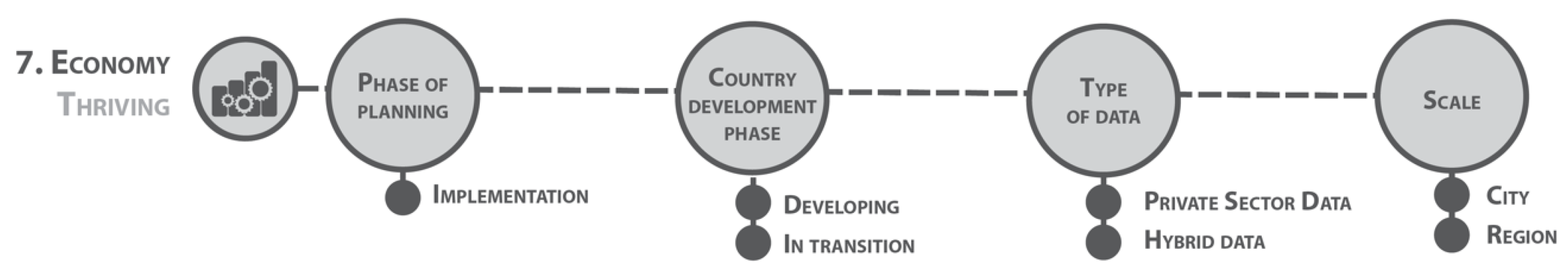
    (1) Scale—Depending on what kind of action is needed, the area defined for intervention can vary; therefore, selected case studies are supposed to give the possibility of implementation on various scales.
    -
    (2) Type of data—For each planning process, individual studies and solutions are designed; therefore, each project requires a different type of data from different sources and owners.
    -
    (3) Country development phase—Each place has a different specificity and capacity, so the case studies present projects from different continents and countries: still developing, in transition, and developed.
    -
    (4) Phase of planningThe circular approach requires that not only tools for planning and implementation, but also for evaluation and finally for improving existing solutions, are analyzed.
    -
    (5) Thematic area—Most importantly, based on the holistic approach, all aspects of city planning should be covered; therefore, the case studies described below address all the goals of the selected framework (introduced in Section 4).
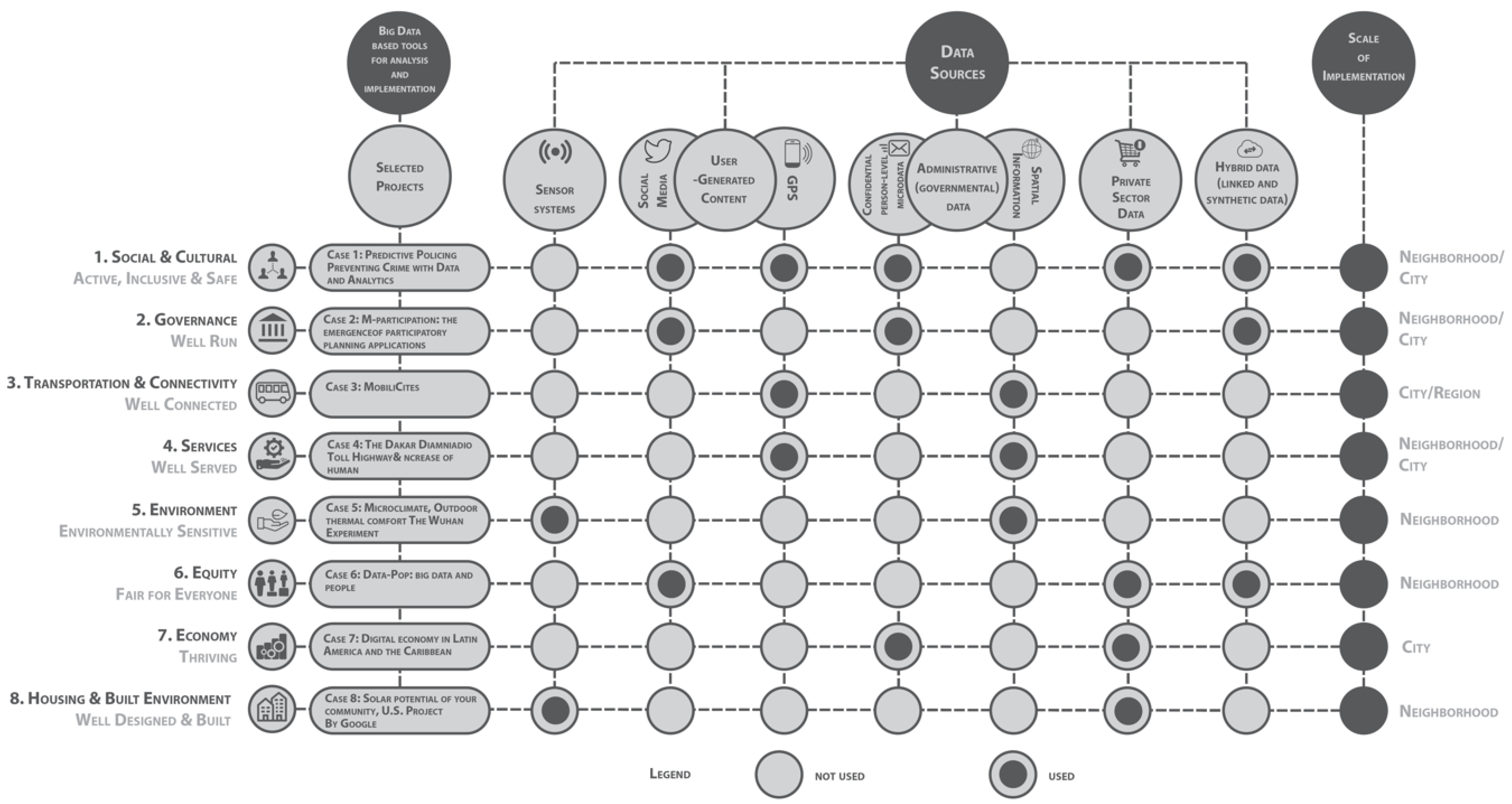
  • Using Urban informatics term as a key word in the conducted literature study, the authors, taking into consideration the above mentioned criteria, studied over 50 examples of projects applying Big Data tools. The search was conducted within projects and publications of or related to the most known data centres, such as the UCL Centre for Advanced Spatial Analysis, MIT Media Lab, MIT Senseable City Lab, Future Cities Laboratory, and Urban Big Data Centre.
  • To further the aim of recognizing the potential usability of Big Data in supporting regenerative planning projects, the conceptual framework for a model was introduced and tested as the main result of the research. The most suitable Big Data-based projects allowing for analysis aimed at enhancing design sustainability were mapped upon these aspects according to the developed model.
  • Finally, the test run for a model’s usability allowed us to draw conclusions on how projects using Big Data-based tools support a regenerative approach in the present, as well as in which areas their role could be enhanced.

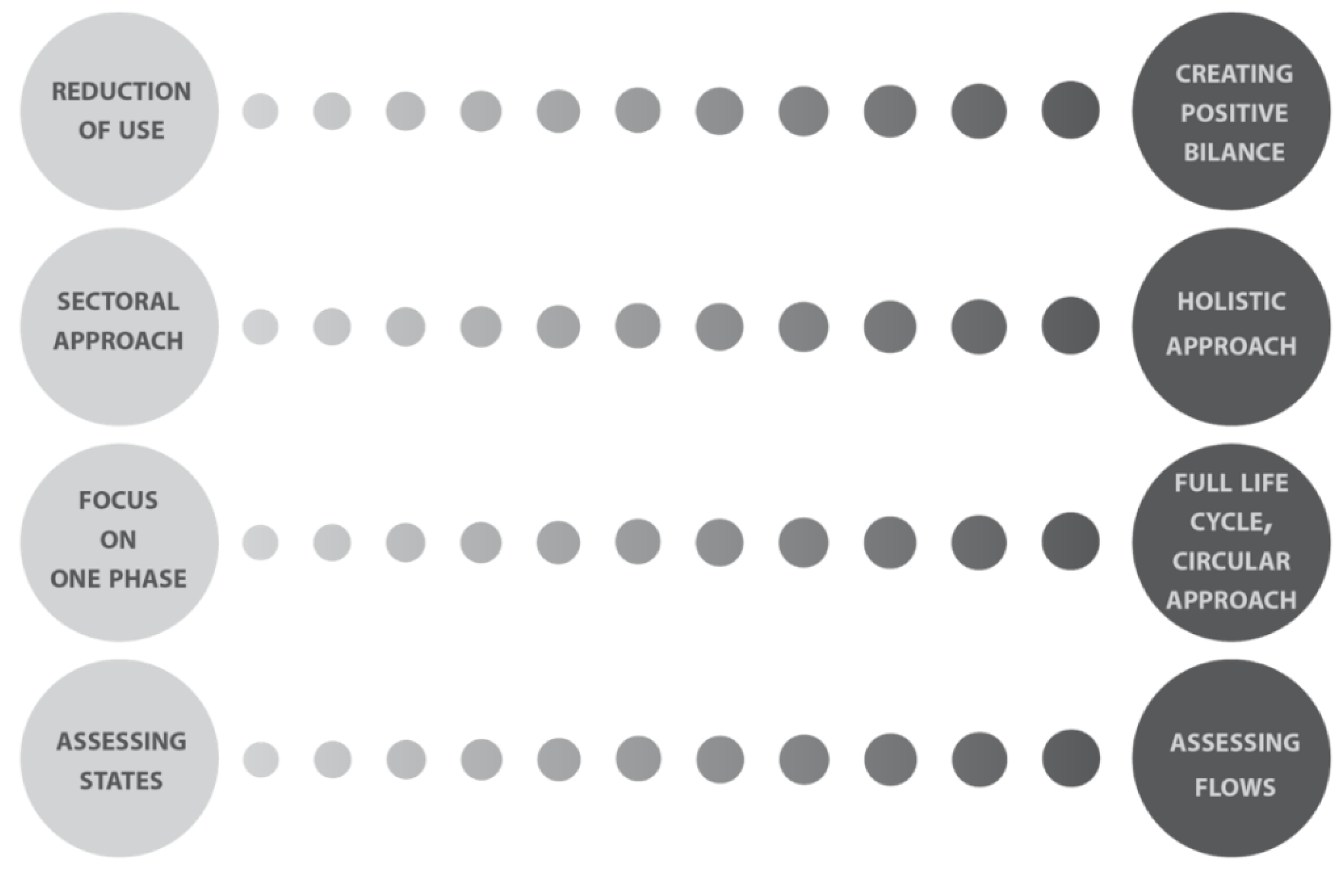
4. Evolution of Frameworks for Assessing Sustainability

Local Agendas 21 [26,27], introduced at the Earth Summit 1992, is an example which became a holistic instrument, allowing the measurement of the actual state and future directions of urban development. In parallel, other standards and sets of indicators used to measure sustainability at the global level were introduced. Probably, the most-known are the Sustainable Development Goals [21], adopted in 2015 and further operationalized on the local scale. However, their usability in assessing single projects is limited. For the purpose of our studies, we analysed other important sets of indicators. Our main criteria of selection were their level of comprehensiveness and universality of use. Important sets of indicators were introduced within initiatives such as: City Blueprint (Waternet Amsterdam; KWR Water; Cycle Research Institute), European Green City Index (Economist Intelligence Unit; Siemens), and Urban Ecosystem Europe (International Council for Local Environmental Initiatives (ICLEI)), focusing primarily on environmental issues. Significant frameworks used to assess the implementation of urban regeneration projects are, among others: The China Urban Sustainability Index (Urban China Initiative), the Indicators for Sustainability (Sustainable Cities International), the Reference Framework for Sustainable Cities (RFSC), and STAR Community Rating System Sustainability Tools for Assessing and Rating Communities.
The table below identifies which frameworks can be considered as the most useful for assessing regenerative approaches in designing and planning processes. To create the table, frameworks were assessed in terms of the extent to which they measure features of regenerative settlements (described in Section 2).
In recent years, various instruments supporting regenerative sustainability at the building level were introduced, of which the most important are the Living Building Challenge, The Living Environments in Natural, Social and Economic Systems (LENSES) Framework [28,29], and The Regenesis Frameworks [30,31], but their use on an urban scale is still limited. Therefore, they were not taken into consideration during the analysis conducted above.
One of the most widely used approaches to assess sustainability at the community level is the Egan Wheel (developed as part of the Egan Review [32]). It identifies the skills needed to deliver sustainable communities within eight sectors, allowing a relatively easy analysis of various aspects of sustainability, also introduced in the Bristol Accord [33]:
  • (1) active, inclusive, and safe—fair, tolerant, and cohesive with a strong local culture and other shared community activities;
  • (2) well-run—with effective and inclusive participation, representation, and leadership;
  • (3) well-connected—with good transport services and communication linking people to jobs, schools, and health and other services;
  • (4) well-served—with public, private, community, and voluntary services that are appropriate to people’s needs and accessible to all;
  • (5) environmentally sensitive—providing places for people to live that are considerate of the environment;
  • (6) equity—fair for everyone;
  • (7) thriving—with a flourishing, diverse, and innovative local economy;
  • (8) well-designed and -built—featuring quality built and natural environment.
Even though the goals introduced in Egan Wheel are deeply rooted in the traditional sustainability approach, from the analysis above (Figure 3), we can see that they have the potential to be transformed into a more regenerative approach. According to our analysis, Egan Wheel can be used to assess nearly all the aspects of regenerative settlements (although some to a larger extent then others). It is especially very well-suited to assess aspects such as ‘inclusive spaces’, ‘vibrant urban life’, and ‘mixed-land use’, and well-suited to assess ‘sustainable land use’ and ‘positive energy and material flows’. However, it only partly allows an assessment of self-sufficiency. An analysis of existing frameworks has shown that the Egan Wheel is the tool which provides the widest possibilities in measuring features of regenerative settlements on a larger scale (urban and regional). That is why, within this research, the Egan Wheel became a starting point for sustainability assessment, although to transform human settlements to more regenerative ones, we need to use a contextually-based approach created for the purpose of regenerative sustainability assessment. The main aspects distinguishing traditional sustainability assessment frameworks from approaches based on regenerative principles are described below (Figure 4).

5. Review of Current Processes, Tools, and Mechanism of Using Big Data in the Built Environment

The Big Data term, which for the first time appeared in the 90’s [34], was built on the notion of 3 V, which stands for ‘High volume, velocity and variety’ [35]. Today, it is defined as ‘a large-volume, heterogeneous, autonomous data sources with distributed and decentralized control, and seeks to explore complex and evolving relationships among data’ [36]. Many researchers focus on answering the question of what are the possibilities for the future analysis of urban processes, which have emerged with the wider access to large databases [37]. The Big Data term is used to describe a wide spectrum of “naturally-occurring” data generated through transactional, operational, planning, and social activities that are not specifically designed for research [38]. Therefore, next to numerous research identifying opportunities, in many studies, the question about the reliability of Big Data as a source of information is asked [39]. Some researchers even question if Big Data can be considered a reliable enough source that can be used, without verifying this with other research methods, as a base for scientific research. A critical discussion on this subject has been presented in numerous studies [40].
In urban studies, the possibilities of utilizing Big Data are still not fully recognized; however, the results of Big Data-based analysis in chosen sectors of city development have been described in the literature, such as in the work of Shekhar (et al.) [38], Bays and Callanan [41], or Somani and Deka [42]. It is important to mention the publications by Hinssen [43] and Batty [44] considering the potential of Big Data for smart cities’ planning, which mostly recognized the field of use of Big Data in urban studies.
Furthermore, various researchers describe areas where Big Data-based analysis is used or can be used in spatial planning, environmental quality and pollution assessment, and outdoor climate and human well-being studies, based on projects implemented in various parts of the world, all aiming to support sustainable planning. What is noticeable is the quite limited number of projects where a holistic approach to sustainable development based on Big Data was introduced [45]. Most of them are only focused on selected issues and goals, and more importantly, almost none of them focus on regenerative design in city planning [9].
So far, Big Data-based tools have been applied as a supportive solution in many projects oriented on sustainable development that was widely described by, e.g., F. Hu (et al.) [46]. Such data is often a base for shaping sustainable polices [47]; however, its usability in regenerative planning is still, to a large extent, not recognised.

6. Classification of Data Sources Supporting Regenerative Planning

Before introducing a holistic approach to analyzing urban processes using Big Data-based tools, a full recognition and classification of data sources is needed. The typology of urban Big Data, which gave a base for this research, has been introduced, among others, by Thakuriah et al. [24]:
  • Sensor systems gathered data (infrastructure-based or moving object sensors)—most often including information on environmental issues, as well as blue and green infrastructure, provided by the public sector and completed by researchers.
  • User-Generated Content (“social” or “human” sensors)—information generated by online activity, including social media, but also when using GPS systems. Databases are organized by private business; however, quite often with open access, since collected data is provided by Internet users.
  • Administrative (governmental) data, both open and confidential micro-data—accessible in Europe due to the implementation of the INSPIRE directive, managed by public institutions, consisting of information such as: (bank) transactions, taxes etc.; but also confidential (on the level of the individual micro-data), concerning, e.g., employment and health. The important aspect of such data is spatial information infrastructure supporting most urban analyses.
  • Private Sector Data (customer and transactions records)—with limited access provided by the private business, e.g., financial institutions, including information on business records and customer profile.
  • Hybrid data (linked and synthetic data)—linked with Big Data although completed with surveys or census-administrative records conducted by, e.g., planning institutions, as well as governmental organizations.
In order to enable a holistic approach to design and planning, there is a need to integrate those data sources and combine them with other more traditional methods of urban assessment.

7. Model of Analysis to Implement Big Data Use in the Sustainable Design and Planning Process

The literature review shows [48,49] that there are many opportunities to enhance regenerative design when using assessment tools by combining clear cases of regenerative implementation with already proven solutions (such as traditional GIS analyses or surveys). The Big Data-based tools provide interoperable databases, allowing different data to be linked together, which can be a support for regenerative planning. Additionally, Big Data, above all, gives a chance for easier access to the opinions of space users. Therefore, tools based on such data are often considered an important source of information for introducing solutions strengthening participation in planning.
All of the above-mentioned phases shaped a model allowing an analysis of the Big Data-based tools potentially supporting regenerative planning. For the test run of its usability, the case studies were selected according to the adopted criteria described in Section 3 and briefly introduced below. The summary of the testing part is presented in Figure 5, where data sources, the type of project, and the scale of its implementation were analyzed. This scheme was further developed by introducing the case studies described following Bristol Accord goals, and enriched with information such as the phases of planning the project support and country of implementation development phase in relation to selected criteria.
Internet users, by posting their opinions about places they visit on social media, quite often, even unconsciously, value the space and produce information which can become a base for analysis conducted by city planners and researchers. Based on such possibilities, the team from MIT designed an algorithm—Street Score [50]—which analyses, thanks to both Google Street View and inhabitants’ responses, the safety of particular spaces. The results allow the shaping of a map which shows a hierarchy of streets of cities such as New York, Chicago, Boston, or Philadelphia, explaining which places are perceived as requiring intervention. Similarly, the project introducing a platform for predictive policing and crime prevention with data analysis, answers the first goal of the Egan Wheel. The tool is designed to support prevention, criminal justice, and law enforcement strategies. The platform consists of three components oriented to the analysis of space, time, and social networks [51]. Another example is a project gathering geo-located opinions, which provides a database useful for monitoring needs regarding healthcare and introducing preventive projects in locations where they are required [52].
In case studies related to social and cultural aspects (Figure 6), there is a possibility to use all types of data: user-generated content, administrative data, private sector data, and hybrid data. It is also worth noticing that data related to social aspects can only be collected in the location where studied activity appears. Much data is connected with social phenomena occurring in the urban realm and is gathered by different agents; however, its use in planning is still not fully recognized. One can say that the range of its use is still limited in comparison to the other aspects, such as transportation and connectivity or environmental aspects.
The research project on M-Participation described by Erito [53] can be considered as a useful tool for the implementation of the second goal of the Egan Wheel. It is focused on introducing better management and governance, which was created in order to support neighbourhood planning, based on a participatory approach, where the information gathered from social media is further analyzed using sentiment analysis. It is worth noting that social media data provides a solid base for seeking recommendations for strengthening governance and introducing better management, as has been presented in the research by, among others: Michels [54], McAfee and Brynjolfsson [55], and Provost and Fawcett [56].
In this aspect, Big Data is mostly used in the analytical, pre-design phase and during the evaluation of the process (Figure 7); however, there are also significant case studies involving the participatory design process. The most valuable data in this area related to users’ opinions which can support decision-making processes in the city. Such data in the majority of cases can be retrieved from social media; however, their reliability is unfortunately limited, as it often only shows the opinions of a chosen group. The most useful data for such projects is that gathered by the private sector; however, its access is often costly or even impeded.
The most common applications of Big Data-based tools are in transportation models (Figure 8). Therefore, many examples of already implemented solutions can be found. It is more common to use such a solution in the organization of traffic in a city and for improving the quality of public transportation, as has been done, among others, in the project MobiliCities [57]. The tool allows for improving the traffic in cities and regions in France, including reorganization and increasing the efficiency of public transportation. When implementing such solutions, it is necessary to analyse the flows of residents in the city. Since the majority of the population uses smartphones with open access for tracking their location, with time, this task is becoming easier.
Big Data-based tools are used in the majority of cases for evaluating and improving existing solutions. There is also potential to use them for new investments during the planning phase; however, during this study, no such cases were identified.
The majority of projects dealing with traffic infrastructure are based on data gathered from users’ mobile devices (Figure 9), as was done in the analysis conducted within the Dakar Diaminia, where Fetzer and Sy [58] assessed how new urban development is changing mobility patterns and improving the accessibility of different parts of the city. The aim of this research was to analyze how the highways are changing the behaviour of residents, as well as to define to what extent accessibility to particular parts of the metropolitan area, offering numerous jobs, has changed.
The majority of studies where Big Data is used to assess access to services are conducted by the private sector only (e.g., analysis of shopping centre catchment areas) and unfortunately, such tools are not commonly used in the planning process. In order to strengthen the use of Big Data in this field, it would be beneficial to build cross-sector cooperation. It is also a reason why such analysis, in the better part of cases, only covers a limited area of the city. Such solutions are mostly tested as pilot projects, and there is a need for their wider roll-out in the future.
The next most recognized group of projects includes those using Big Data analysis for environmental studies (Figure 10). As a relevant example, the experiment conducted by Huang (et al.) [59] can be mentioned. By using a sensors system, the research team analyzed the microclimate and outdoor thermal comfort of urban spaces where new investments were implemented or searched for locations where they are needed. In such projects, Big Data is most often used as a source for analysis to evaluate changes appearing in the public spaces of neighbourhoods. Another example, although of a different nature, is a platform which was created in New York for inventorying trees to recognize areas where greenery requires intervention and to control changes taking place in the natural environment of the city. Thanks to the involvement of volunteers and with the strong support of Google Street View, the resulting database is constantly updated [60].
Projects from this aspect are very often based on sensor systems, which limits their coverage and may generate high costs of additional data gathering infrastructure, if wider implementation is needed. At the same time, environmental databases are all over the world better structured and more often updated than in other aspects of planning, as in the area of environmental analysis, Big Data tools were used much earlier. Additionally, solutions are more systemic, as data (as e.g., flood protection data) is gathered by public administration.
The project which uses Big Data as a tool for fulfilling goal 6 of the Egan Wheel (Figure 11) is undoubtedly the proposal presented by the team from Harvard Humanitarian Initiative and MIT Media Lab, where Big Data is used as a supporting tool aiming to identify local needs and to improve decision-making and political processes in the researched areas [61]. The strategic goal of the project is to show how the data and tools serve the interests of people across the globe, especially of marginalized and vulnerable populations, by empowering them to use Big Data to improve decision-making processes.
Such projects have a key role to play, especially in areas with a high level of disparities, as a supportive tool for fighting poverty and improving the quality of life. However, it is also worth mentioning examples of projects enhancing social inclusion in developed countries. Two main areas where they occur are: equalizing access to services and widely understood regeneration of blighted areas. They can be used in all phases of the planning process; however, there are more examples where such tools are used when conducting analysis or while implementing solutions. Among analyzed case studies, we have not found any projects in the phase of evaluation.
An interesting tool was introduced in the Caribbean and Latin America, where Big Data is used to improve the national capabilities for measuring and fostering the digital economy, which corresponds with goal 7 of the Egan Wheel (Figure 12). The research showed that the region’s main challenge is establishing a true dialogue between the national statistics offices and the most important Big Data actors, who are mostly private. Most of the conducted analyses were studying relationships between the digital economic components and socio-demographic variables related to development and inclusion (such as production structure, innovation intensity, employment, gender issues, etc.) [62].
Projects from this aspect require a close cooperation between sectors: private, public, and civic. There is a need to embed them strongly in public statistics. In order to foster economic growth, solutions need to be initiated by the governmental sector. It is worth noting that such projects are implemented in both developed and developing countries (in this situation, often with the support of global agents).
Within the project proposed by Google, using analysis based on the point cloud model, a map for chosen American cities was created, where the algorithm allows for recording the level of insulation and shows profitability in the use of solar panels for each building. At the same time, the user can find out where the sun operates the longest and how much energy at specific times of the year will be generated as a result of investing in a renewable energy source. A simulation showing the investment return period is also available. The project aims at energy savings and increasing environmental sensitivity while improving the quality of life in urban areas [63]. The same aim was adopted when designing The Atlas of ReUrbanism [64]—an evolving and expanding tool, allowing its users to explore the built environment block by block to review the age and technical condition of individual buildings in all American cities. At the same time, this tool makes it possible to define areas where intervention is most needed.
Such analyses are used in all scales of interventions, mostly at the early phases of planning (Figure 13). As the buildings are usually private, it is easier to use incentive tools to intervene in the urban tissue, such as in the case of the above-mentioned project in American cities. In areas where urban tissue already exists, it is certainly easier to involve stakeholders in the transformation of public space then intervene in buildings.
These selected examples of Big Data-based projects show how the sustainable planning processes can be supported by linking data from different sources and integrating different solutions. The authors argue that only when integrating the data sources and different sectoral interventions can we speak of a holistic approach to the use of Big Data to support enhancing the regenerative development of human settlements. Additionally, the case study analysis has shown that Big Data can be supportive at all phases of the design process, such as recognizing needs, programming solutions, and implementing them, as well as during the evaluation phase, which aims to improve the design.

8. Discussion

As pointed out by Erickson (et al.), Hancke&Hancke, and Zanella (et al.), the conducted study confirms that there are already multiple systems based on Big Data for capturing and monitoring human-ecosystem relations in urban space [8,9,65]; however, their range is often sectoral ((Figure 14). Analysis shows that the lack of integration of urban systems indicated by Tzoulas (et al.) [4] and by Shen (et al.), at the level of the building [10], is also reflected in the fact that there are no holistic projects using Big Data-based tools that integrate different systems of the city. From the definition, Big Data is seldom harmonized, and our study also confirmed that processing data to achieve similar standards, qualities, and ranges for them to be used together [11], is a boundary condition for their usefulness.
Thompson and Newman [23] point out that the implementation of regenerative planning requires a circular approach and a monitoring of the flows instead of states, and Big Data, by its very nature—describing the phenomenon continuously, not at given points in time—can be considered an appropriate tool for this issue.
The majority of analyzed projects do not focus only on the mitigation of negative phenomena, but are trying to create a positive balance, which is a major feature of the regenerative approach [17]. A valid example could be the project by Google of ‘Solar potential of your community U.S.’ [63] or ‘Data-Pop’ introduced by MIT Media Lab [61]. However, it is not common to all case studies, e.g., transport projects connected with transport—MobiliCities [57] focuses on the reduction of congestion, while not trying to influence the mobility patterns.

9. Conclusions

There is significant potential for using Big Data-based tools to support various phases and aspects of regenerative planning. It is important that such tools can be contextually-based and enhance participatory solutions. Analyzing selected case studies, it can be noted that there are relevant initiatives where Big Data is used to enhance chosen aspects of design sustainability, supporting the planning and design of more sustainable inclusive territories and places. Initiatives are based on multi-stakeholders and a co-creational approach, and allow the needs of populations to be met. At the same time, analyses performed during this study show that, unfortunately, so far, there have not been very many integrated solutions implemented or tested. There is a strong need to change the sectoral approach and propose more holistic solutions which utilise Big Data. Many solutions are based on a traditional sustainable approach aimed at the reduction of use, rather than creating a positive balance or improving the health of the systems.
If we want to implement Big Data tools to support more integrated solutions, there is a need for interoperability and data linking. So far, non-Big Data-based tools have provided the possibility of obtaining a full picture of any specific problems, although most of the instruments offer the possibility to compliment analysis using different kinds of tools and are open to new research fields, as well as new approaches, e.g., connected with sentiments analysis, which can be used for gathering preferences/perceptions of the users of urban spaces. Big Data sources can be considered useful (1) at the preliminary phase of the design process when conducting analyses; (2) while designing solutions strongly based on collected data; and (3) at the evaluation phase of particular solutions and design improvements.
Big Data-based tools can be used at various scales of intervention. They can also cover various aspects of sustainable development. However, there are also a lot of challenges which appear when implementing Big Data instruments in spatial analysis. Similarly to a critical discussion by Comber (et al.) [66], the biggest concerns are reliability and compatibility, but also the accessibility and security of the data, in the context of public and proprietary information. Additionally, the quantity of data does not allow for verifying possible mistakes or gaps [67]. Moreover, in many cases, the existing data does not fully cover all areas of analysed cities. For example, when using user generated data such as those from social media, the researcher cannot receive a full picture as the results only cover locations where the studied activity appears [59]. Also, sensor systems only allow the analyzing of limited areas and the costs of obtaining private sector generated data can impede the possibility of large-scale implementation of the tool which is using such data.
While evaluating the usability and the effectiveness of Big Data for spatial analysis, it can be seen that there is a strong potential for using Big Data-based tools for supporting regenerative solutions as they describe the process, not the state.
Big Data solutions related to regenerative design face different problems depending on the area of analysis. For example, when analysing projects related to social or governmental aspects, it can be noticed that data includes only part of the population. Therefore, any user-generated data, such as those obtained from social media, can only be considered as a source of additional information, as it is very difficult to obtain a statistical sample reflecting the entire population. At the same time, there are a number of examples showing how useful such data is while complementing analyses or implementing transport-related solutions. Similar situations can be pointed out when analyzing Big Data as a tool for strengthening management, crime prevention, or health monitoring.
Moreover, even though it should be noted that the specificity and accessibility of data limit its possible use in certain types of projects, there are many possible ways of using Big Data in regenerative design and planning. However, Big Data-based tools can only be considered as reliable when systematic solutions and database standards are introduced. To achieve this, it is vital to integrate instruments based on Big Data in regenerative design by focusing on newer interdisciplinary processes and digital tools.
The conducted research allowed the assessment of the possibilities created by Big Data-based tools in supporting regenerative design and planning; however, the study did not cover the analysis of Big Data tools. An analysis defining which tools are the most suitable for different types of projects should be conducted as a further step in the research. The assessment conducted during this study shows a lack of holistic projects (dealing with all the aspects of regenerative planning), which is why an analysis of the boundary conditions, which would support the implementation of integrated projects, might also be beneficiary. Finally, within a further step of this research, a system on the usage of Big Data in regenerative planning can be designed.

Author Contributions

Conceptualization, D.K.-Z. and H.O.-P. Methodology, D.K.-Z. and H.O.-P. Investigation, D.K.-Z. and H.O.-P.; Resources, D.K.-Z. and H.O.-P. Writing-Original Draft Preparation, D.K.-Z. and H.O.-P. Writing-Review & Editing, D.K.-Z. and H.O.-P. Visualization, H.O.-P.

Funding

This research was founded from statutory funds of Gdansk University og Technology, Architecture Department.

Acknowledgments

The article was developed in terms of the COST Action CA16114 ‘RESTORE: Rethinking Sustainability towards a Regenerative Economy’. More information can be found at www.eurestore.eu/. The authors would like to thank Emanuele Naboni (The Royal Danish Academy of Fine Arts Schools of Architecture, Design and Conservation, Copenhagen, Denmark) and Giulia Sonetti (Interuniversity Department of Regional & Urban Studies and Planning, Politecnico di Torino and Università di Torino, Turin, Italy) for their valuable feedback, notably in improving the structure of the paper and nuancing the discussion.

Conflicts of Interest

The authors declare no conflict of interest.

References

  1. Lohr, S. The age of Big Data. N.Y. Times 2012. Available online: http://www.nytimes.com/2012/02/12/sunday-review/big-datas-impact-in-the-world.html?_r=0j (accessed on 5 January 2018).
  2. Sassen, S. Agglomeration in Digital Era in: Cities in a World Economy; Pine Forge Press: London, UK, 2000. [Google Scholar]
  3. Boyd, J.; Banzhaf, S. What are ecosystem services? The need for standardized environmental accounting units. Ecol. Econ. 2007, 63, 2–3. [Google Scholar] [CrossRef]
  4. Sukhdev, P.; Wittmer, H.; Schröter-Schlaack, C.; Nesshöver, C.; Bishop, J.; Brink, P.T.; Gundimeda, H.; Kumar, P.; Simmons, B. The Economics of Ecosystems and Biodiversity: Mainstreaming the Economics of Nature: A Synthesis of the Approach, Conclusions and Recommendations of TEEB; UNEP: Mandaluyong, Philippines, 2010; Available online: http://doc.teebweb.org/wp-content/uploads/Study%20and%20Reports/Reports/Synthesis%20report/TEEB%20Synthesis%20Report%202010.pdf (accessed on 25 July 2018).
  5. Tzoulas, K.; Korpel, K.; Vennc, S.; Yli-Pelkonen, V.; Kaźmierczak, A.; Niemel, J.; James, P. Promoting ecosystem and human health in urban areas using Green Infrastructure: A literature review. Landsc. Urban Plan. 2007, 81, 167–178. [Google Scholar] [CrossRef] [Green Version]
  6. Pardo, T.A. Conceptualizing smart city with dimensions of technology, people, and institutions. In Proceedings of the 12th Annual International Digital Government Research Conference: Digital Government Innovation in Challenging Times, College Park, MD, USA, 12–15 June 2011; pp. 282–291. [Google Scholar]
  7. Sonetti, G. Di cosa parlano quando parlano di resilienza urbana. CRIOS 2016, 12. [Google Scholar] [CrossRef]
  8. Hancke, G.P.; Hancke, J.G.P. The role of advanced sensing in smart cities. Sensors 2012, 13, 393–425. [Google Scholar] [CrossRef] [PubMed]
  9. Zanella, A.; Bui, N.; Castellani, A.; Vangelista, L.; Zorzi, M. Internet of things for smart cities. IEEE Internet THINGS J. 2014, 1, 22–32. [Google Scholar] [CrossRef]
  10. Shen, W.; Hao, Q.; Mak, H.; Neelamkavil, J.; Xie, H.; Dickinson, J.; Thomas, R.; Pardasani, A.; Xue, H. Systems integration and collaboration in architecture, engineering, construction, and facilities management: A review. Adv. Eng. Inform. 2010, 24, 196–207. [Google Scholar] [CrossRef] [Green Version]
  11. Lombardi, P.; Osello, A.A.A.; Patti, E.; Macii, E.; Sonetti, G. Web and Cloud Management for Building Energy Reduction: Toward. In Handbook of Research on Demand-Driven Web Services: Theory, Technologies, and Applications: Theory, Technologies, and Applications; Sun, Z., Yearwoo, J., Eds.; IGI Global: Hershey, PA, USA, 2014. [Google Scholar]
  12. Hollands, R.G. Will the real smart city please stand up? Intelligent, progressive or entrepreneurial? City 2008, 12, 303–320. [Google Scholar] [CrossRef]
  13. Steiner, F. Frontiers in urban ecological design and planning research’, Landscape and urban planning. Landsc. Urban Plan. 2014, 125, 304–311. [Google Scholar] [CrossRef]
  14. Fink, H.S.; Kaltenegger, I. Integration of Mother Nature into Smart Buildings. In Integration of Nature and Technology for Smart Cities; Ahuja, A., Ed.; Springer: New York, NY, USA, 2016; pp. 225–261. [Google Scholar]
  15. Heynen, N.; Kaika, M.; Swyngedouw, E. Urban political ecology: Politicizing the production of urban natures. In The Nature of Cities: Urban Political Ecology and the Politics of Urban Metabolism; Heynen, N.C., Kaika, M., Swyngedouw, E., Eds.; Routledge: Abingdon, UK, 2006. [Google Scholar]
  16. Conte, E.; Monno, V. The regenerative approach to model an integrated urban-building evaluation method. Int. J. Sustain. Built Environ. 2016, 5, 12–22. [Google Scholar] [CrossRef]
  17. Brown, M. FutuREstorative: Working Towards a New Sustainability; RIBA Publishing: Newcastle, UK, 2016. [Google Scholar]
  18. Du Plessis, C. Towards a Regenerative Paradigm for the Built Environment. Build. Res. Inf. 2012, 40, 7–22. [Google Scholar] [CrossRef]
  19. Rees, W.E. Achieving Sustainability: Reform or Transformation. In The Earthscan Reader in Sustainable Cities; Satterhwaite, D., Ed.; Earthscan: London, UK, 1999; pp. 22–52. [Google Scholar]
  20. Capra, F. The Hidden Connections; HarperCollins: London, UK, 2002; Available online: http://beahrselp.berkeley.edu/wp-content/uploads/2010/06/Capra-Hidden-Connections-Ch-4.pdf (accessed on 5 January 2018).
  21. United Nations General Assembly. Transforming Our World: The 2030 Agenda for Sustainable Development; United Nations General Assembly: New York, NY, USA, 2015. [Google Scholar]
  22. United Nations. Habitat III New Urban Agenda; United Nations: Quito, Ecuador, 2016. [Google Scholar]
  23. Thomson, G.; Newman, P. Urban Fabrics and Urban Metabolism: From Sustainable to Regenerative Cities. Resour. Conserv. Recycl. 2017, 132, 218–229. [Google Scholar] [CrossRef]
  24. Thakuriah, P.; Tilahun, N.; Zellner, M. Big Data and Urban Informatics: Innovations and Challenges to Urban Planning and Knowledge Discovery. In Seeing Cities Through Big Data; Springer: Cham, Switzerland, 2015; pp. 4–32. [Google Scholar]
  25. Seawright, J.; Gerring, J. Case Selection Techniques in Case Study Research: A Menu of Qualitative and Quantitative Options. Polit. Res. Q. 2008, 61, 294–308. [Google Scholar] [CrossRef]
  26. UN-Habitat. Best Practices and Local Leadership Programme; UN-Habitat: Nairobi, Kenya, 2009. [Google Scholar]
  27. UN-Habitat. The Global Campaign on Urban Governance; UN-Habitat: Nairobi, Kenya, 2002. [Google Scholar]
  28. Plaut, J.; Dunbar, B.; Gotthelf, H.; Hes, D. Regenerative Development through LENSES with a case study of Seacombe West. EDG 2016, 88, 1–16. [Google Scholar]
  29. Plaut, J.M.; Dunbar, B.; Wackerman, A.; Hodgin, S. Regenerative design: The lenses framework for buildings and communities. Build. Res. Inf. 2012, 40, 112–122. [Google Scholar] [CrossRef]
  30. Mang, P.; Haggard, B. Regenerative Development and Design: A Framework for Evolving Sustainability; John Wiley & Sons, Inc.: Hoboken, NJ, USA, 2016. [Google Scholar]
  31. Regenesis. The Regenerative Practitioner™—What is Regenerative Development. 2017. Available online: http://www.regenesisgroup.com/wp-content/uploads/2015/03/What_is_Regenerative_Development.pdf (accessed on 5 January 2018).
  32. Office of the Deputy Prime Minister. The Egan Review. Skills for Sustainable Communities; Office of the Deputy Prime Minister: London, UK, 2004.
  33. Office of the Deputy Prime Minister. Bristol Accord. Conclusions of Ministerial Informal on Sustainable Communities in Europe UK PRESIDENCY; The Office of the Deputy Prime Minister: Bristol, UK, 2005.
  34. Weiss, S.; Indrukhya, N. Predictive Data Mining: A Practical Guide; Morgan Kaufmann: Burlington, NJ, USA, 1998. [Google Scholar]
  35. Laney, D. 3-D Data Management: Controlling Data Volume, Velocity, and Variety; META Group Research Note; META Group: Stamford, CT, USA, 2001. [Google Scholar]
  36. Xindong, W.; Xiangquan, Z.; Gong-Qing, W.; Wei, D. Data mining with Big Data. IEEE Trans. Knowl. Data Eng. 2013, 26, 97–107. [Google Scholar] [CrossRef]
  37. Fan, W.; Bifet, A. Mining Big Data: Current status and forecast to the future. SIGKDD Explor. 2012, 14, 1–5. [Google Scholar] [CrossRef]
  38. Shekhar, S.; Zhang, P.; Raju, V.R.; Huang, Y. Trends in Spatial Data Mining. In Next Generation Challenges and Future Directions. In Proceedings of the NSF 1st workshop on Future Directions in Data Mining; MIT Press: Boston, MA, USA, 2003. [Google Scholar]
  39. Mayer-Schönberger, V.; Cukier, K. Big Data: A Revolution That Will Transform How We Live, Work, and Think; Houghton Mifflin Harcourt: Boston, MA, USA, 2013. [Google Scholar]
  40. Kitchin, R. Big data and human geography Opportunities, challenges and risks. Hum. Geogr. 2013, 3, 262–267. [Google Scholar] [CrossRef]
  41. Bays, J.; Callanan, L. ‘Urban informatics’ can Help Cities Run more Efficiently; McKinsey on Society: New York, NY, USA, 2012; Available online: http://mckinseyonsociety.com/emerging-trends-in-urbaninformatics/ (accessed on 5 January 2018).
  42. Somani, A.K.; Deka, G.C. (Eds.) Big Data Analytics Tools and Technology for Effective Planning; Routledge: New York, NY, USA, 2017. [Google Scholar]
  43. Hinssen, P. (Ed.) Open Data, Power, Smart Cities How Big Data Turns Every City into a Data Capital; Across Technology: Mount Evelyn, Australia, 2012; Available online: http://datascienceseries.com/assets/blog/Greenplum-Open_Data_Power_Smart_Cities-web.pdf (accessed on 5 January 2018).
  44. Batty, M. Urban Informatics and Big Data. A Report to the ESRC Cities Expert Group. Available online: http://www.smartcitiesappg.com/wp-content/uploads/2014/10/Urban-Informatics-and-Big-Data.pdf (accessed on 5 January 2018).
  45. Taylor, L. Sustainable Data Science for Sustainable Cities: Big Data and the Challenge of Urban Development; Opinion Paper; EADI, chance2sustain: Bonn, Germany, 2014; Available online: http://www.chance2sustain.eu/fileadmin/Website/Dokumente/Dokumente/Publications/publications_2014/C2S_OP_No10_WP5_Sustainable_Data_Science_for_Sustainable_Cities.pdf (accessed on 5 January 2018).
  46. Hu, F.; Liu, W.; Tsai, S.B.; Gao, J.; Bin, N.; Chen, Q. An empirical study on visualizing the intellectual structure and hotspots of big data research from a sustainable perspective. Sustainability 2018, 10, 667. [Google Scholar] [CrossRef]
  47. Can, U.; Alatas, B. Big Social Network Data and Sustainable Economic Development. Sustainability 2017, 9, 2027. [Google Scholar] [CrossRef]
  48. Serras, J.; Bosredon, M.; Herranz, R.; Batty, M. Urban Planning and Big Data—Taking LUTi Models to the Next Levelø. Nordregio 2014, 1. Available online: http://www.nordregio.se/en/Metameny/Nordregio-News/2014/Planning-Tools-for-Urban-Sustainability/Reflection/%201/ (accessed on 5 January 2018).
  49. Castells, M. The Informational City: Information Technology, Economic Restructuring, and the Urban-Regional Process; Blackwell: Oxford, UK, 1989. [Google Scholar]
  50. StreetScore. Available online: http://streetscore.media.mit.edu/ (accessed on 5 January 2018).
  51. Bachner, J. Predictive Policing Preventing Crime with Data and Analytics; IBM Center for The Business of Government: Washington, DC, USA, 2013.
  52. Barrett, M.A.; Humblet, O.; Hiatt, R.A.; Adler, N.E. Big Data and Disease Prevention: From Quantified Self to Quantified Communities. Big Data 2013, 1, 168–175. [Google Scholar] [CrossRef] [PubMed]
  53. Ertio, T. M-participation: The Emergence of Participatory Planning Applications; Turku Urban Research Programme: Turku, Finland, 2013; Available online: https://www.turkuai.fi/sites/default/files/atoms/files/tutkimuskatsauksia_2013-6b.pdf (accessed on 5 January 2018).
  54. Michels, A. Innovations in democratic governance: How does citizen participation contribute to a better democracy? Int. Rev. Admin. Sci. 2011, 77, 275–293. [Google Scholar] [CrossRef]
  55. McAfee, A.; Brynjolfsson, E. Big Data: The Management Revolution. Harvard Bus. Rev. 2012, 90, 60–68. [Google Scholar]
  56. Provost, F.; Fawcett, T. Data Science and its Relationship to Big Data and Data-Driven Decision Making. Data Science. Big Data 2013, 1, 51–59. [Google Scholar] [CrossRef] [PubMed]
  57. MobiliCites. Available online: http://www.mobilicites.com/ (accessed on 5 January 2018).
  58. Fetzer, T.; Sy, A. Big Data and Sustainable Development: Evidence from the Dakar Metropolitan Area in Senegal. 2015. Available online: https://www.brookings.edu/blog/africa-in-focus/2015/04/23/big-data-and-sustainable-development-evidence-from-the-dakar-metropolitan-area-in-senegal/ (accessed on 5 January 2018).
  59. Huang, J.; Zhou, C.; Zhuo, Y.; Xu, L.; Jiang, Y. Outdoor Thermal Environments and Activities in Open Space: An Experiment Study in Humid Subtropical Climates. Build. Environ. 2016, 103, 238–249. [Google Scholar] [CrossRef]
  60. Tree Map. Available online: https://tree-map.nycgovparks.org/learn/about (accessed on 5 January 2018).
  61. Data-Pop: Big Data and People. Available online: https://www.odi.org/projects/2759-data-pop-big-data-and-people (accessed on 5 January 2018).
  62. Big Data Measuring and Fostering Digital Economy Latin America and Caribbean. Available online: https://www.cepal.org/en/projects/big-data-measuring-and-fostering-digital-economy-latin-america-and-caribbean (accessed on 5 January 2018).
  63. Google Project SunRoof. Available online: https://www.google.com/get/sunroof/data-explorer/ (accessed on 5 January 2018).
  64. The Atlas. Available online: http://forum.savingplaces.org/act/pgl/atlas/map (accessed on 5 January 2018).
  65. Erickson, V.L.; Carreira-Perpiñán, M.Á.; Cerpa, A.E. OBSERVE: Occupancy-based system for efficient reduction of HVAC energy. In Proceedings of the 10th International Conference on Information Processing in Sensor Networks (IPSN), Changsha, China, 12–14 April 2011; pp. 258–269. [Google Scholar]
  66. Comber, A.J.; Fisher, P.F.; Harvey, F.; Gahegan, M.; Wadsworth, R. Using metadata to link uncertainty and data quality assessments. In Progress in Spatial Data Handling; Riedl, A., Kainz, W., Elmes, G., Eds.; Springer: Berlin/Heidelberg, Germany, 2006; pp. 279–292. [Google Scholar]
  67. Goodchild, M.F. The quality of big (geo) data. Dialogues. Hum. Geogr. 2013, 3, 280–284. [Google Scholar] [CrossRef]
Figure 1. Phases of developing a conceptual framework of the model for the use of Big Data in assessing regenerative planning projects. Source: Authors’ own elaboration.
Sustainability 10 03668 g001
Figure 2. Conceptual framework for a model to assess the possibilities created by Big Data-based tools in supporting regenerative design and planning. Source: Authors’ own elaboration.
Sustainability 10 03668 g002
Figure 3. Analysis of frameworks for assessing sustainability in the context of their usability in regenerative approaches. Source: Authors’ own elaboration.
Sustainability 10 03668 g003
Figure 4. The transition from a sustainable to regenerative approach based on key elements shaping a regenerative approach. Source: Authors’ own elaboration.
Sustainability 10 03668 g004
Figure 5. Test of the model—case studies, data sources, and the scale of implementation. Source: Authors’ own elaboration.
Sustainability 10 03668 g005
Figure 6. Test of the model—elaboration of goal related to social and cultural aspects. Source: Authors’ own elaboration.
Sustainability 10 03668 g006
Figure 7. Test of the model—elaboration of goal related to governance aspect. Source: Authors’ own elaboration.
Sustainability 10 03668 g007
Figure 8. Test of the model—elaboration of goal related to transportation and connectivity aspect. Source: Authors’ own elaboration.
Sustainability 10 03668 g008
Figure 9. Test of the model—elaboration of goal related to service aspect. Source: Authors’ own elaboration.
Sustainability 10 03668 g009
Figure 10. Test of the model—elaboration of goal related to environmental aspect. Source: Authors’ own elaboration.
Sustainability 10 03668 g010
Figure 11. Test of the model—elaboration of goal related to equity aspect. Source: Authors’ own elaboration.
Sustainability 10 03668 g011
Figure 12. Test of the model—elaboration of goal related to economy aspect. Source: Authors’ own elaboration.
Sustainability 10 03668 g012
Figure 13. Test of the model—elaboration of goal related to housing aspect. Source: Authors’ own elaboration.
Sustainability 10 03668 g013
Figure 14. Research summary—Presence of key elements shaping the regenerative approach in analyzed projects. Source: Authors’ own elaboration.
Sustainability 10 03668 g014

