Comparative Changes of Influence Factors of Rural Residential Area Based on Spatial Econometric Regression Model: A Case Study of Lishan Township, Hubei Province, China

 , ,
, ,  and
and
Abstract
:1. Introduction
- This paper introduced the spatial regression model and selected five main influencing factors of rural residential areas: elevation, slope, water system, roads, and townships as the evaluation indexes, and quantified the influence degree of these factors.
- This paper made a comparative study on the change of the degree of the main influencing factors in rural residential areas in 2009, 2012, and 2015.
2. Data and Methods
2.1. Study Region
2.2. Data Sources and Processing
2.3. Methods
2.3.1. Near Analysis and Topographic Index
2.3.2. Kernel Density Estimation
2.3.3. Spatial Econometric Regression Model
3. Results and Analysis
3.1. Changes in the Rural Residential Areas
3.2. Topography Is of Vital Importance and the “Hydrophilicity” Is Abnormal
3.3. Traffic Access and Town Radiation Influence Increase
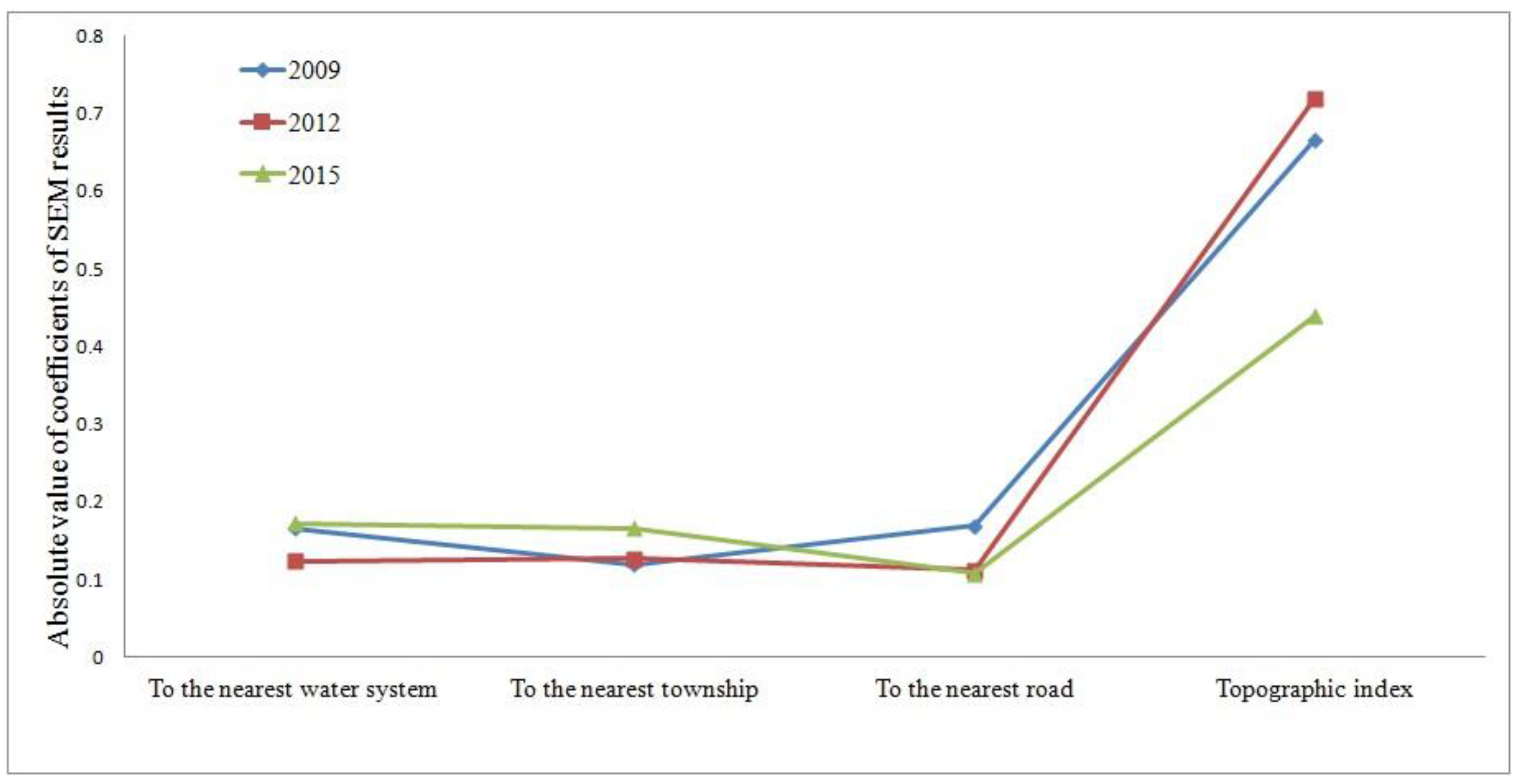
3.4. Comparison of Influencing Factors Change in 2009, 2012, and 2015
4. Discussion
5. Conclusions
Author Contributions
Funding
Conflicts of Interest
References
- Li, Y.R.; Liu, Y.S.; Long, H.L.; Cui, W.G. Community-based rural residential land consolidation and allocation can help to revitalize hollowed villages in traditional agricultural areas of China: Evidence from Dancheng County, Henan Province. Land Use Policy 2014, 39, 188–198. [Google Scholar] [CrossRef]
- Wang, H.; Wang, L.L.; Su, F.B.; Tao, R. Rural residential properties in China: Land use patterns, efficiency and prospects for reform. Habitat Int. 2011, 36, 201–209. [Google Scholar] [CrossRef]
- Ma, W.Q.; Jiang, G.H.; Zhang, R.J.; Li, Y.L.; Jiang, X.G. Achieving rural spatial restructuring in China: A suitable framework to understand how structural transitions in rural residential land differ across peri-urban interface? Land Use Policy 2018, 75, 583–593. [Google Scholar] [CrossRef]
- Shan, Z.Y.; Feng, C.C. The Redundancy of Residential Land in Rural China: The evolution process, current status and policy implications. Land Use Policy 2018, 74, 179–186. [Google Scholar] [CrossRef]
- Hong, X. Analysis and Countermeasures on Effective Land Use of Rural Residential Area in Jinan, Shandong Province. Chin. J. Popul. Resour. Environ. 2006, 4, 41–44. [Google Scholar] [CrossRef]
- Yan, W.; Xu, Y.M. Exchange of Rural Residential Land in China. Asian Soc. Sci. 2010, 6, 111. [Google Scholar] [CrossRef]
- Peng, Y.; Zhu, X.T.; Zhang, F.Y. Farmers’ risk perception of concentrated rural settlement development after the 5.12 Sichuan Earthquake. Habitat Int. 2018, 71, 169–176. [Google Scholar] [CrossRef]
- Wang, Y. A Sustainable Approach for Post-Disaster Rehabitation of Rural Heritage Settlements. Sustain. Dev. 2016, 24, 319–329. [Google Scholar] [CrossRef]
- Constantin, V.; Ştefănescu, L.; Kantor, C.-M. Vulnerability assessment methodology: A tool for policy makers in drafting a sustainable development strategy of rural mining settlements in the Apuseni Mountains, Romania. Environ. Sci. Policy 2015, 52, 129–139. [Google Scholar] [CrossRef]
- Peng, Y. A comparison of two approaches to develop concentrated rural settlements after the 5.12 Sichuan Earthquake in China. Habitat Int. 2015, 49, 230–242. [Google Scholar] [CrossRef]
- Yang, R.; Xu, Q.; Long, H.L. Spatial distribution characteristics and optimized reconstruction analysis of China’s rural settlements during the process of rapid urbanization. J. Rural Stud. 2016, 47, 413–424. [Google Scholar] [CrossRef] [Green Version]
- Lv, J.; Zhang, K.B. Type Analysis of Rural Settlements Development of Hadaqi Region in Heilongjiang Province. Appl. Mech. Mater. 2014, 587, 119–122. [Google Scholar] [CrossRef]
- Adekunle, I.M.; Adetunji, M.T.; Gbadebo, A.M.; Banjoko, O.P. Assessment of groundwater quality in a typical rural settlement in Southwest Nigeria. Int. J. Environ. Res. Public Health 2008, 4, 307–318. [Google Scholar] [CrossRef]
- Pan, Y.; Zhuo, X.L. The Study of Modern Evolution of Rural Settlement Pattern in Chaoshan—Case Study of Xinhe Village. Appl. Mech. Mater. 2014, 584, 497–500. [Google Scholar] [CrossRef]
- Qu, Y.B.; Jiang, G.H.; Zhao, Q.L. Geographic identification, spatial differentiation, and formation mechanism of multifunction of rural settlements: A case study of 804 typical villages in Shandong Province, China. J. Clean. Prod. 2017, 166, 1202–1215. [Google Scholar] [CrossRef]
- Cao, Y.G.; Bai, Z.K.; Sun, Q.; Zhou, W. Rural settlement changes in compound land use areas: Characteristics and reasons of changes in a mixed mining-rural-settlement area in Shanxi Province, China. Habitat Int. 2017, 61, 9–21. [Google Scholar] [CrossRef]
- Omoruyi, B.; Matongo, F.; Nkwetshana, N.T.; Green, E.; Clarke, A.M.; Ndip, R.N. Environmental and demographic risk factors associated with the prevalence of Cryptosporidium infection in the Alice rural settlements of the Eastern Cape Province of South Africa: A pilot study. Rev. Environ. Health 2011, 26, 127–133. [Google Scholar] [CrossRef] [PubMed]
- Long, H.L.; Liu, Y.S.; Wu, X.Q.; Dong, G.H. Spatio-temporal dynamic patterns of farmland and rural settlements in Su–Xi–Chang region: Implications for building a new countryside in coastal China. Land Use Policy 2008, 26, 322–333. [Google Scholar] [CrossRef]
- Altić, M.S. Physiognomic and Morphological Characteristics of the Rural Settlements of the Varaždin Generalate and Križevci County. Podrav. Sci. Multidiscip. Res. J. 2011, 10, 24–37. [Google Scholar]
- Liu, Y.S.; Yang, Y.Y.; Li, Y.R.; Li, J.T. Conversion from rural settlements and arable land under rapid urbanization in Beijing during 1985–2010. J. Rural Stud. 2017, 51, 141–150. [Google Scholar] [CrossRef]
- Tian, G.J.; Yang, Z.F.; Zhang, Y.Q. The Spatio-Temporal Dynamic Pattern of Rural Residential Land in China in the 1990s Using Landsat TM Images and GIS. Environ. Manag. 2007, 40, 803–813. [Google Scholar] [CrossRef] [PubMed]
- Liu, Q.Q.; Pan, Y.C.; Chen, B.S.; Li, S.H.; Guo, A.Q. Analysis on the Relationship and its Dynamics Between Rural Settlements and Linear Features Using Gis and Rs. Intell. Autom. Soft Comput. 2012, 18, 1053–1062. [Google Scholar] [CrossRef]
- Tian, Y.S.; Kong, X.S.; Liu, Y.L. Combining weighted daily life circles and land suitability for rural settlement reconstruction. Habitat Int. 2018, 76, 1–9. [Google Scholar] [CrossRef]
- Tian, Y.S.; Liu, Y.F.; Kong, X.S. Restructuring rural settlements based on mutualism at a patch scale: A case study of Huangpi District, central China. Appl. Geogr. 2018, 92, 74–84. [Google Scholar] [CrossRef]
- Tian, Y.S.; Liu, Y.F.; Liu, X.J.; Kong, X.S.; Liu, G.G. Restructuring rural settlements based on subjective well-being (SWB): A case study in Hubei province, central China. Land Use Policy 2017, 63, 255–265. [Google Scholar] [CrossRef]
- Xi, J.C.; Wang, X.G.; Kong, Q.Q.; Zhang, N. Spatial morphology evolution of rural settlements induced by tourism. J. Geogr. Sci. 2015, 25, 497–511. [Google Scholar] [CrossRef]
- The Bureau of Land Resource Suizhou. Available online: http://www.szgtzy.gov.cn/ (accessed on 2 August 2016).
- The Bureau of Land Resource Suixian. Available online: http://www.zgsuixian.gov.cn/sxgt/ (accessed on 25 June 2015).
- Suixian People’s Government. Available online: www.zgsuixian.gov.cn (accessed on 6 September 2016).
- Yu, H.; Zeng, H.; Jiang, Z.Y. Study on the distribution of landscape components on topographic gradient in rapidly urbanized areas. Geoscience 2001, 21, 64–69. [Google Scholar]
- Okabe, A.; Satoh, T.; Sugihara, K. A kernel density estimation method for networks, its computational method and a GIS-based tool. Int. J. Geogr. Inf. Sci. 2009, 23, 7–32. [Google Scholar] [CrossRef]
- Fleming, C.H.; Calabrese, J.M. A new kernel density estimator for accurate home-range and species-range area estimation. Methods Ecol. Evol. 2017, 8, 571–579. [Google Scholar] [CrossRef]
- Barry, R.P.; McIntyre, J. Estimating animal densities and home range in regions with irregular boundaries and holes: A lattice-based alternative to the kernel density estimator. Ecol. Model. 2011, 222, 1666–1672. [Google Scholar] [CrossRef] [Green Version]
- Junho, L.; Ronald, E.G.; Jun, Z. Cluster detection of spatial regression coefficients. Stat. Med. 2017, 36, 1118–1133. [Google Scholar]
- Mahara, G.; Wang, C.; Yang, K.; Chen, S.; Guo, J.; Gao, Q.; Wang, W.; Wang, Q.; Guo, X. The Association between Environmental Factors and Scarlet Fever Incidence in Beijing Region: Using GIS and Spatial Regression Models. Int. J. Environ. Res. Public Health 2016, 13, 1083. [Google Scholar] [CrossRef] [PubMed]
- Tian, W.; Song, J.T.; Li, Z.Y. Spatial regression analysis of domestic energy in urban areas. Energy 2014, 76, 629–640. [Google Scholar] [CrossRef]
- Yang, X.Y.; Jin, W. GIS-based spatial regression and prediction of water quality in river networks: A case study in Iowa. J. Environ. Manag. 2010, 91, 1943–1951. [Google Scholar] [CrossRef] [PubMed]
- Ren, P.; Hong, K.; Zhou, J.M. Research on spatio-temporal evolution and characteristics of rural settlements based on spatial autocorrelation model. Resour. Environ. Yangtze River Basin 2015, 24, 1993–2002. [Google Scholar]
- Wang, Y. An edge-suppressed points voting method for extracting rural residential areas from high spatial resolution images. Remote Sens. Lett. 2017, 8, 380–388. [Google Scholar] [CrossRef]
- Chee, K.L.; Catalán, F.; Torrico, S.A.; Kürner, T. Modeling tree scattering in rural residential areas at 3.5 GHz. Radio Sci. 2014, 49, 44–52. [Google Scholar] [CrossRef] [Green Version]
- Blaunstein, N.; Censor, D.; Katz, D.; Freedman, A.; Matityahu, I. Radio propagation in rural residential areas with vegetation—Abstract. J. Electromagn. Waves Appl. 2003, 17, 131–153. [Google Scholar] [CrossRef]
- Yao, Y.M.; Zhu, X.D.; Xu, Y.B.; Yang, H.Y.; Wu, X.; Li, Y.F.; Zhang, Y.F. Assessing the visual quality of green landscaping in rural residential areas: The case of Changzhou, China. Environ. Monit. Assess. 2012, 184, 951–967. [Google Scholar] [CrossRef] [PubMed]
- Anselin, L.; Florax, R.; Rey, S.J. Advances in Spatial Econometrics: Methodology, Tools and Applications; Springer: New York, NY, USA, 2004. [Google Scholar]


| Elevation (m) | Number of Rural Residential Areas | Area and Ratio (/hm2, %) | ||||
|---|---|---|---|---|---|---|
| In 2009 | In 2012 | In 2015 | In 2009 | In 2012 | In 2015 | |
| 57–102 (I) | 449 | 440 | 454 | 772.05 (60.28%) | 763.44 (60.44%) | 773.39 (60.74%) |
| 102~142 (II) | 390 | 385 | 386 | 484.55 (37.87%) | 473.14 (37.46%) | 473.38 (37.18%) |
| 142~211 (III) | 33 | 34 | 34 | 23.91 (1.87%) | 26.25 (2.08%) | 26.25 (2.06%) |
| 211~319 (IV) | 2 | 2 | 2 | 0.32 (0.02%) | 0.32 (0.03%) | 0.32 (0.03%) |
| 319~514 (V) | 0 | 0 | 0 | 0.00 (0.00%) | 0.00 (0.00%) | 0.00 (0.00%) |
| Total | 874 | 861 | 876 | 1280.83 (100%) | 1263.15 (100%) | 1273.34 (100%) |
| Slope (°) | Number of Rural Residential Areas | Area and Ratio (/hm2, %) | ||||
|---|---|---|---|---|---|---|
| In 2009 | In 2012 | In 2015 | In 2009 | In 2012 | In 2015 | |
| 0~5 (I) | 770 | 757 | 772 | 1190.98 (92.99%) | 1171.41 (92.74%) | 1181.84 (92.81%) |
| 5~10 (II) | 89 | 89 | 89 | 79.64 (6.22%) | 81.53 (6.45%) | 81.29 (3.38%) |
| 10~15 (III) | 9 | 9 | 9 | 6.19 (0.48%) | 6.18 (0.49%) | 6.18 (0.49%) |
| 15~25 (IV) | 6 | 6 | 6 | 4.02 (0.31%) | 4.03 (0.32%) | 4.03 (0.32%) |
| 25~37 (V) | 0 | 0 | 0 | 0.00 (0.00%) | 0.00 (0.00%) | 0.00 (0.00%) |
| Total | 874 | 861 | 876 | 1280.83 (100%) | 1263.15 (100%) | 1273.34 (100%) |
| Buffer (km) | Number of Rural Residential Areas | Area and Ratio (/hm2, %) | ||||
|---|---|---|---|---|---|---|
| In 2009 | In 2012 | In 2015 | In 2009 | In 2012 | In 2015 | |
| 0~1 (I) | 548 | 530 | 538 | 809.20 (63.18%) | 781.80 (61.89%) | 791.89 (62.19%) |
| 1~2 (II) | 241 | 246 | 253 | 340.45 (26.58%) | 350.14 (27.72%) | 350.25 (27.51%) |
| 2~3 (III) | 60 | 61 | 61 | 89.32 (6.97%) | 90.23 (7.14%) | 90.23 (7.09%) |
| 3~4 (IV) | 21 | 20 | 20 | 32.06 (2.50%) | 31.18 (2.47%) | 31.18 (2.45%) |
| 4~5 (V) | 4 | 4 | 4 | 9.80 (0.77%) | 9.79 (0.78%) | 9.79 (0.77%) |
| Total | 874 | 861 | 876 | 1280.83 (100%) | 1263.15 (100%) | 1273.34 (100%) |
| Buffer (km) | Number of Rural Residential Areas | Area and Ratio (/hm2, %) | ||||
|---|---|---|---|---|---|---|
| In 2009 | In 2012 | In 2015 | In 2009 | In 2012 | In 2015 | |
| 0~1 (I) | 508 | 495 | 568 | 680.96 (53.17%) | 666.45 (52.76%) | 812.68 (63.82%) |
| 1~2 (II) | 165 | 164 | 127 | 301.69 (23.55%) | 282.03 (22.33%) | 187.46 (14.72%) |
| 2~3 (III) | 115 | 115 | 100 | 181.81 (14.19%) | 192.75 (15.26%) | 159.49 (12.52%) |
| 3~4 (IV) | 59 | 60 | 54 | 82.62 (6.45%) | 88.16 (6.98%) | 79.96 (6.82%) |
| >4 (V) | 27 | 27 | 27 | 33.75 (2.46%) | 33.75 (2.67%) | 33.75 (2.65%) |
| Total | 874 | 861 | 876 | 1280.83 (100%) | 1263.15 (100%) | 1273.34 (100%) |
| Buffer (km) | Number of Rural Residential Areas | Area and Ratio (/hm2, %) | ||||
|---|---|---|---|---|---|---|
| In 2009 | In 2012 | In 2015 | In 2009 | In 2012 | In 2015 | |
| 0~2.5 (I) | 467 | 536 | 597 | 689.05 (53.80%) | 871.50 (68.99%) | 936.02 (75.51%) |
| 2.5~5 (II) | 240 | 191 | 156 | 387.71 (30.27%) | 257.31 (20.37%) | 218.42 (17.15%) |
| 5~7.5 (III) | 140 | 107 | 96 | 181.99 (14.21%) | 112.25 (8.89%) | 96.81 (7.60%) |
| 7.5~10 (IV) | 21 | 21 | 21 | 19.16 (1.50%) | 19.17 (1.52%) | 19.17 (1.51%) |
| 10–12.5 (V) | 6 | 6 | 6 | 2.92 (0.23%) | 2.92 (0.23%) | 2.92 (0.23%) |
| Total | 874 | 861 | 876 | 1280.83 (100%) | 1263.15 (100%) | 1273.34 (100%) |
| Variables | In 2009 | In 2012 | In 2015 | ||||||
|---|---|---|---|---|---|---|---|---|---|
| Coefficient | Standard Deviation | Z-Value | Coefficient | Standard Deviation | Z-Value | Coefficient | Standard Deviation | Z-Value | |
| Constant | 0.875 | 0.033 | 26.302 *** | 0.899 | 0.031 | 29.060 *** | 0.895 | 0.042 | 21.438 *** |
| Water system | 0.166 | 0.092 | 1.816 * | 0.124 | 0.091 | 1.366 | 0.173 | 0.100 | 1.724 ** |
| Town | 0.120 | 0.065 | 1.856 * | 0.127 | 0.064 | 1.980 * | 0.166 | 0.073 | 0.905 ** |
| Road | 0.170 | 0.062 | 2.738 *** | 0.112 | 0.056 | 1.988 * | 0.108 | 0.070 | 1.552 ** |
| Topographic index | 0.666 | 0.239 | 2.782 *** | 0.719 | 0.270 | 2.665 *** | 0.439 | 0.307 | 1.430 ** |
| LAMBDA | 0.058 | 0.307 | 0.189 | 0.055 | 0.296 | 0.187 | 0.244 | 0.269 | 0.911 |
© 2018 by the authors. Licensee MDPI, Basel, Switzerland. This article is an open access article distributed under the terms and conditions of the Creative Commons Attribution (CC BY) license (http://creativecommons.org/licenses/by/4.0/).
Share and Cite
Zhang, X.; He, J.; Deng, Z.; Ma, J.; Chen, G.; Zhang, M.; Li, D. Comparative Changes of Influence Factors of Rural Residential Area Based on Spatial Econometric Regression Model: A Case Study of Lishan Township, Hubei Province, China. Sustainability 2018, 10, 3403. https://doi.org/10.3390/su10103403
Zhang X, He J, Deng Z, Ma J, Chen G, Zhang M, Li D. Comparative Changes of Influence Factors of Rural Residential Area Based on Spatial Econometric Regression Model: A Case Study of Lishan Township, Hubei Province, China. Sustainability. 2018; 10(10):3403. https://doi.org/10.3390/su10103403
Chicago/Turabian StyleZhang, Xuesong, Ju He, Zhen Deng, Jiyue Ma, Guangping Chen, Maomao Zhang, and Deshou Li. 2018. "Comparative Changes of Influence Factors of Rural Residential Area Based on Spatial Econometric Regression Model: A Case Study of Lishan Township, Hubei Province, China" Sustainability 10, no. 10: 3403. https://doi.org/10.3390/su10103403
APA StyleZhang, X., He, J., Deng, Z., Ma, J., Chen, G., Zhang, M., & Li, D. (2018). Comparative Changes of Influence Factors of Rural Residential Area Based on Spatial Econometric Regression Model: A Case Study of Lishan Township, Hubei Province, China. Sustainability, 10(10), 3403. https://doi.org/10.3390/su10103403