
Bidirectional Adaptation of Shared Autonomous Vehicles and Old Towns’ Urban Spaces: The Views of Residents on the Present

 , ,
, ,  ,
,
Abstract
1. Introduction
- L0: No driving automation;
- L1: Driver assistance;
- L2: Partial driving automation;
- L3: Conditional driving automation;
- L4: High driving automation;
- L5: Full driving automation.
- This study contributes to the empirical enrichment of the ripple model by focusing on the user demand within the spatial context of old towns.
- It also explores the potential impacts of SAV technology on the spatial structures of old towns from the perspective of urban residents. Specifically, it proposes adaptive development strategies for Suzhou’s historic districts to promote the organic integration of SAVs with traditional urban environments.
- To investigate urban residents’ perceptions in the context of SAVs’ integration into old town environments and to identify key spatial renewal priorities during the transitional phase of technological adoption, based on user-centered insights.
- To provide complementary strategies for spatial optimization in urban stock renewal processes, offering a novel perspective tailored to the unique challenges of old town districts.
- While previous studies have examined the impacts of SAVs on urban transportation systems and land use patterns, few have addressed their spatial and socio-cultural implications within the historically layered environments of old town districts.
- Moreover, the majority of existing SAV research remains dominated by simulation-based modeling or large-scale quantitative datasets, often marginalizing the place-based experiences, perceptions, and needs of local residents.
2. Methodology
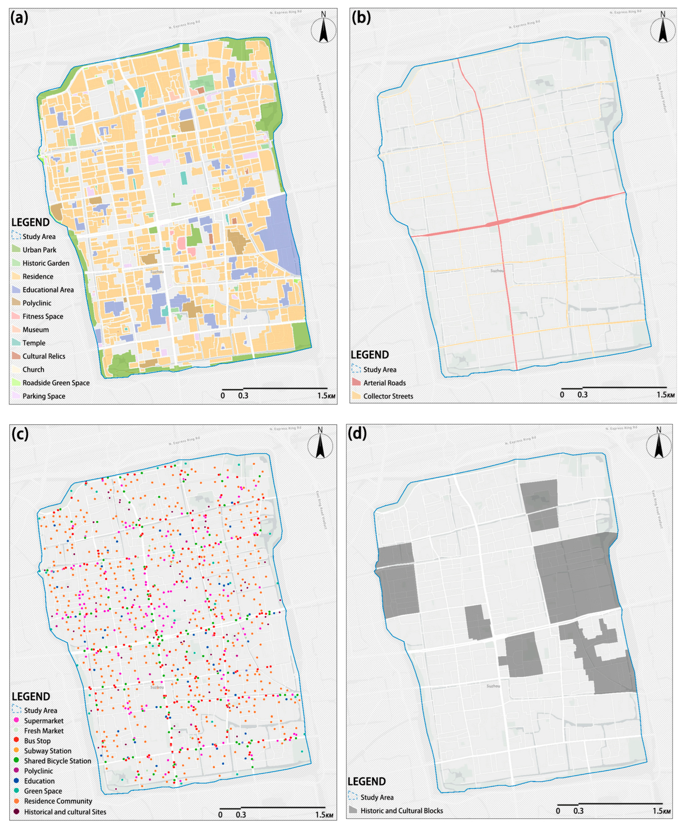
2.1. Study Area
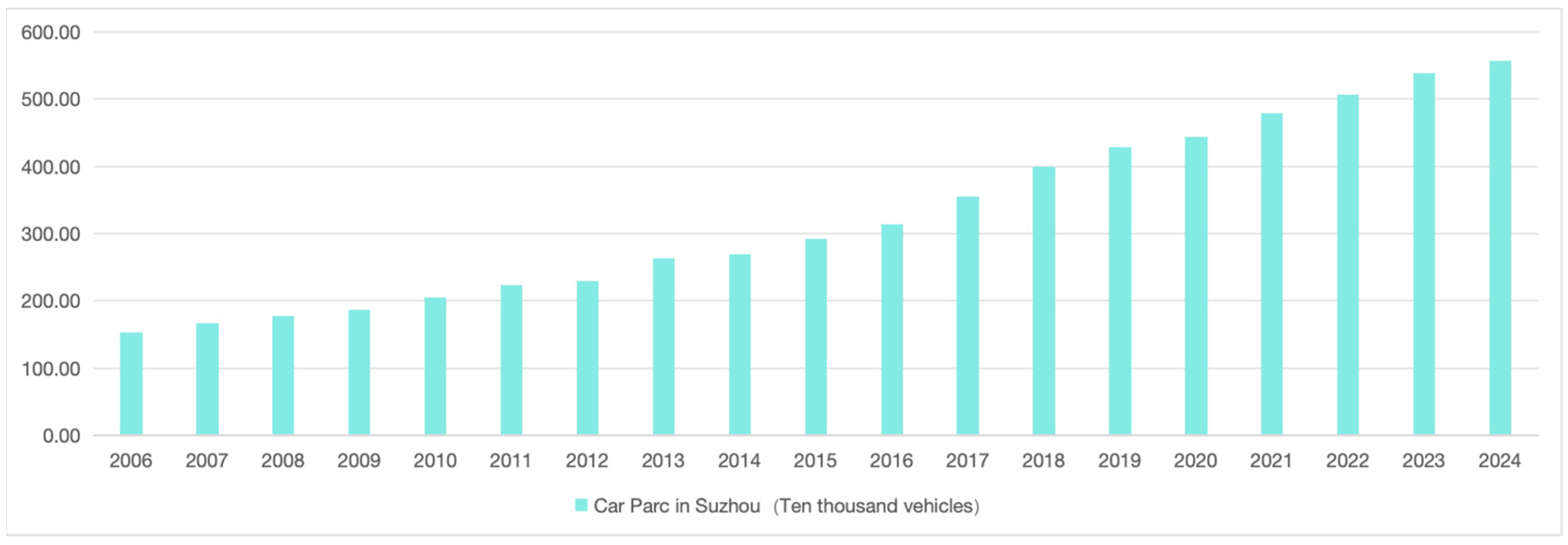
- Representative Urbanization Dynamics: Suzhou’s urbanization rate has reached 81.72%, marking an increase of 11.65% from the 70.07% recorded in the Sixth National Population Census. During this period, the permanent population grew from 10.45 million to 12.74 million, and the urban population increased from 7.32 million to 10.41 million [33]. As a typical representative of China’s densely urbanized regions and a national pilot city for urban–rural integration, Suzhou reflects the broader transition from separation to integration in urban–rural relations and the rationalization of planning paradigms [34]. Therefore, the study of Suzhou’s old town offers a valuable reference for similar contexts in East Asia and beyond.
- Strong Regional Identity and Historic Continuity: Suzhou’s old town retains a highly distinctive spatial identity. Over the past two millennia, its urban form and location have remained remarkably stable [32]. When compared to the historic “Pingjiang Map”, the city’s overall framework, primary water systems, and historic bridges and landmarks remain largely unchanged—an extremely rare phenomenon globally (see Figure 6d). Additionally, the old town’s traditional architectural façades, built heritage, and social customs embody rich cultural value, forming a diverse and distinctive urban landscape [34]. As such, investigating the spatial adaptation of SAVs in Suzhou’s old town offers valuable insights not only for local development but also for the adaptive renewal of historic urban cores across East Asia and other parts of the world.
2.2. Data Collection
- Sociodemographic information: including gender, age, possession of a personal driver’s license, and duration of residence in Suzhou [36];
- Basic understanding of autonomous driving technology;
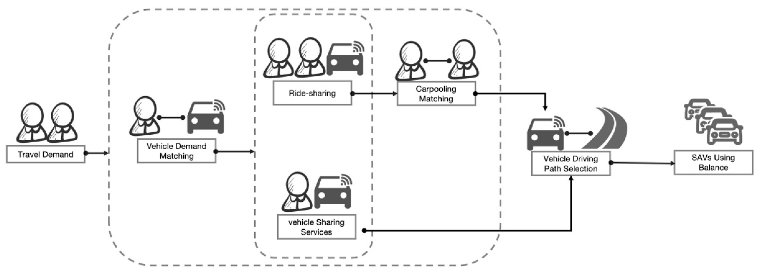
- Urban spatial issues related to the integration of SAVs, based on the ripple model framework;
- Open-ended questions aimed at eliciting broader perspectives.

| Element Layer | Interview Questions | Objective | Source |
|---|---|---|---|
| Basic Understanding | How familiar are you with SAVs? Have you ever experienced riding in an AVs? | To assess respondents’ basic level of knowledge about SAVs. | Etminani-Ghasrodashti et al., 2021 [37] |
| If SAVs were introduced more extensively in Suzhou’s old town, would you prefer using SAVs for your daily travel? Why or why not? | To explore whether the introduction of SAVs may alter residents’ or tourists’ travel behavior. | Etminani-Ghasrodashti et al., 2021 [37] | |
| Residential Population | Do you think the development of SAVs technology would influence your residential location choice? Would you be more willing to live in the city center or suburbs? Why? | To examine whether SAVs could affect the residential distribution, such as encouraging suburban living due to reduced commuting pressure. | Zhang W. et al., 2022 [12]; Zhang and Guhathakurta, 2018 [23] |
| Parking Land Use | Do you think the widespread use of SAVs would reduce the need for parking in the old town? Why or why not? | To investigate the potential reduction in parking demand and its implications for urban land use. | Zhang W. et al., 2022 [12]; Zhang W. et al., 2015 [38] |
| If parking demands were reduced, what types of facilities or spaces would you prefer to see replacing parking lots? | To collect preferences regarding alternative uses of urban land currently occupied by parking facilities. | Xia et al., 2021 [39] | |
| Regional Accessibility | In your opinion, will SAVs change the layout or location of parking facilities in the future? | To explore public perceptions of how SAVs may reshape the existing parking infrastructure. | Xia et al., 2021 [39]; Gu et al., 2023 [40] |
| Do you think SAVs development will improve the accessibility of certain urban areas? Which areas might become more accessible? | To determine whether SAVs might enhance access to remote or peripheral locations, possibly affecting mobility choices. | Milakis et al., 2017 [27] | |
| If SAVs improve accessibility across the city, what impacts would you hope to see on the distribution of commercial, residential, or public service facilities? | To explore expectations regarding how improved connectivity might influence the spatial distribution of urban functions. | Qin et al., 2019 [26]; Zhang W. et al., 2022 [12] | |
| Do you think SAVs will affect how easily tourists can access various urban attractions? Would it change your travel plans? Why or why not? | To understand the potential of SAVs to reshape tourism mobility and influence travel decisions. | Qin et al., 2019 [26]; Zhang W. et al., 2022 [12] | |
| Street Infrastructure and Environment | In your opinion, will the prevalence of SAVs change the design of city streets? | To explore whether the introduction of SAVs will create new demands for street layouts, especially regarding pedestrians and cyclists. | Qin et al., 2019 [26] |
| What aspects of the street environment would you like SAVs to help improve? | To understand expectations for SAVs in improving urban streetscapes (e.g., noise reduction, increased safety, environmental quality). | Ambühl et al., 2016 [21]; Zhang W. et al., 2022 [12] | |
| If SAVs significantly reduce traffic accidents, what changes do you think may occur in street infrastructure? | To guide a discussion of the potential reconfiguration of safety infrastructure and street design. | Qin et al., 2019 [26]; Zhang W. et al., 2022 [12] | |
| With the advancement of SAVs, what changes do you anticipate in the overall urban traffic layout? | To examine the broader urban planning implications of SAV integration, especially in terms of road design and space allocation. | Heinrichs, 2016 [41]; Zhang W. et al., 2022 [12] | |
| Open Perspective | Do you have any other thoughts or suggestions regarding how SAVs may influence the urban spatial structure of Suzhou’s old town? | To allow respondents to provide additional insights or raise points not captured by the structured questions. | Etminani-Ghasrodashti et al., 2021 [37] |
2.3. Data Analysis
- Transcription and Data Compilation
- 2.
- Extraction of Key Information
- 3.
- Unstructured Clustering Based on Affinity
- 4.
- Theme Identification and Categorization
- 5.
- Interpretation and Synthesis
- It facilitated the structuring of fragmented public perceptions into four spatial dimensions derived from the second layer of the ripple model—namely, the residential population distribution, parking land use, regional accessibility, and the street-level environmental quality.
- Through affinity-based clustering and abstraction, these perceptions were synthesized into actionable urban themes that reflected emergent tensions and opportunities in SAV deployment.
- The resulting themes served as a conceptual foundation for the development of targeted, scenario-based spatial strategies in Section 4.2.
2.4. Samples
2.5. Particaipants
2.6. Ethical Considerations
3. Results
3.1. Demographic Characteristics of Interview Participants
3.2. Analysis of Interviews
3.2.1. Interview Results
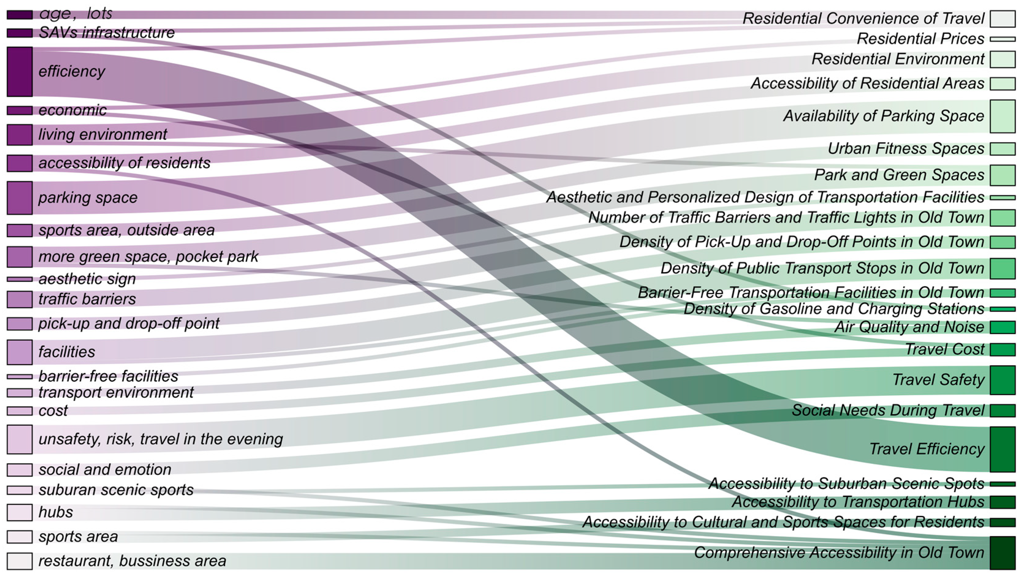
3.2.2. Classifying the Key Information of the Interviews Using the KJ Method
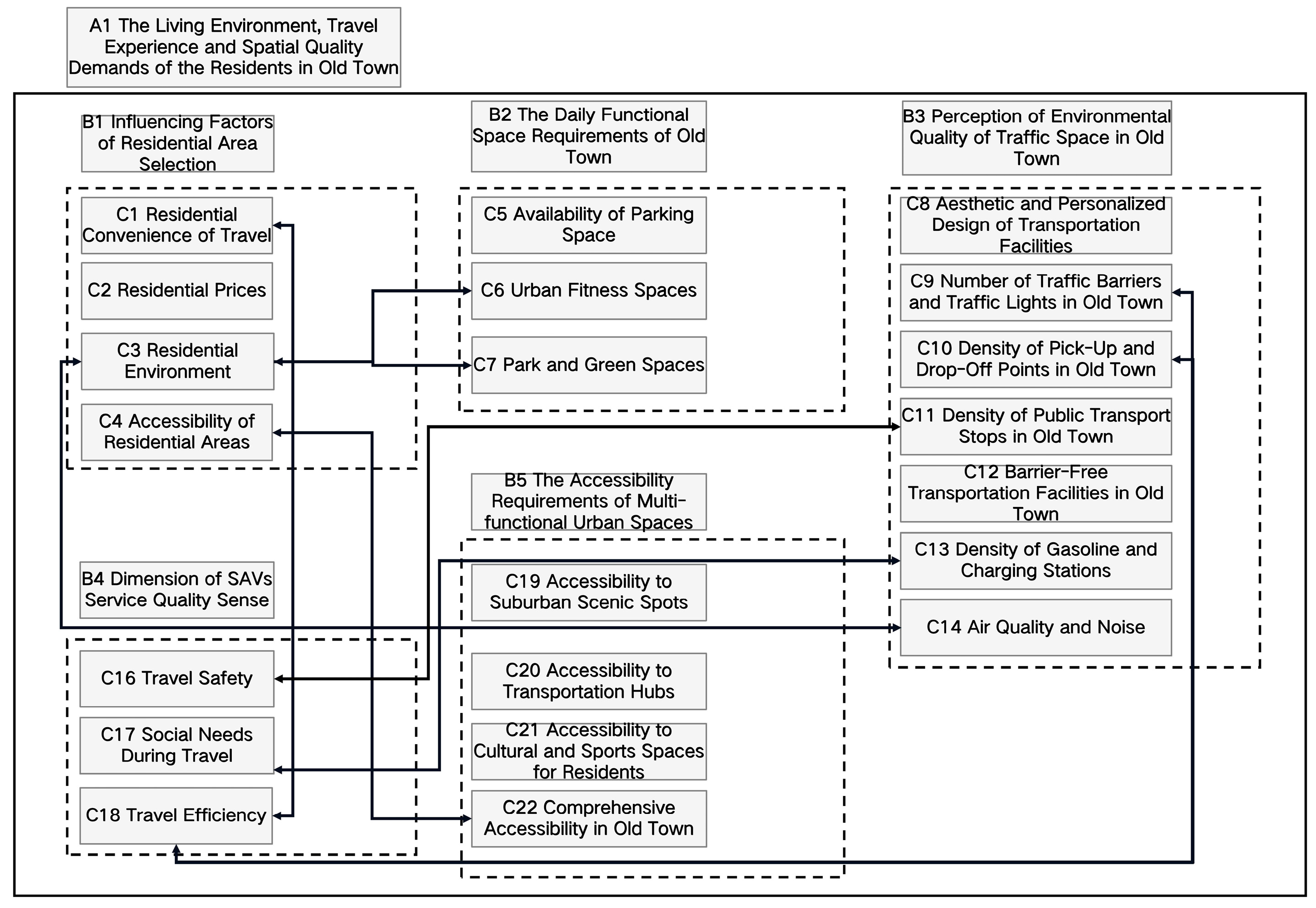
- A1. The living environment, travel experience, and spatial quality demands of the residents in the old town;
- B1. The influencing factors of residential area selection.
- C1. Commuting convenience;
- C2. Residential cost affordability;
- C3. Quality of housing environment;
- C4. Spatial accessibility of residential area.
- 3.
- B2. The daily functional space requirements of the old town.
- C5. Availability of parking spaces;
- C6. Access to fitness and exercise facilities;
- C7. Green and recreational open spaces (e.g., parks, pocket parks).
- 4.
- B3. Perceptions of the environmental quality of traffic spaces in the old town.
- C8. Street safety and orderliness;
- C9. Visual attractiveness and spatial aesthetics;
- C10. Reduction in noise pollution;
- C11. Improvements in air quality;
- C12. Human-centered and inclusive street design;
- C13. Compact and efficient infrastructure layout;
- C14. Harmony between mobility and livability.
- 5.
- B4. Dimension of SAV service quality.
- C15. Affordability and cost-effectiveness of SAVs;
- C16. Safety and risk management in SAV operations;
- C17. Efficiency and reliability of SAV services;
- C18. Emotional and psychological comfort during rides.
- 6.
- B5. The accessibility requirements of multi-functional urban spaces.
- C19. Accessibility to transportation hubs;
- C20. Access to public service facilities;
- C21. Reachability of leisure and tourist destinations;
- C22. Accessibility within and beyond the old town area.
4. Discussion and Conclusions
4.1. User Demand Characteristic Analysis Based on KJ Method
4.2. Practice Strategies
4.2.1. Proposed Strategy 1: Enhancing Public Trust Through Transparent Risk Assessment
- The integration of explainable artificial intelligence (XAI) frameworks is recommended to improve transparency in SAVs’ decision-making processes, thereby reducing public anxiety over so-called “black box” algorithms. In sensitive areas with historical heritage—such as Pingjiang Road—redundant control systems, including emergency manual override options, should be incorporated to minimize safety risks associated with technical malfunctions.
- Additionally, digital twin technologies can be employed to dynamically simulate the traffic flow in Suzhou’s Gusu District, optimizing SAVs’ operational strategies. By visually demonstrating the safety and efficiency of SAV deployment through real-time simulations, public acceptance and confidence in the technology can be significantly enhanced.
4.2.2. Proposed Strategy 2: Adopting a Polycentric Development Strategy to Enhance the Land Use Mix in the Old Town
4.2.3. Proposed Strategy 3: Hierarchical Street Renovation Strategy to Reconcile Traffic Efficiency and Heritage Conservation
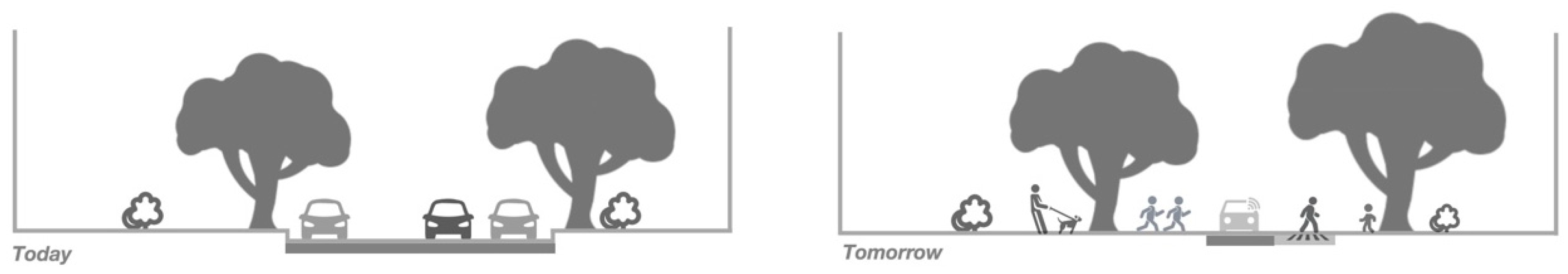
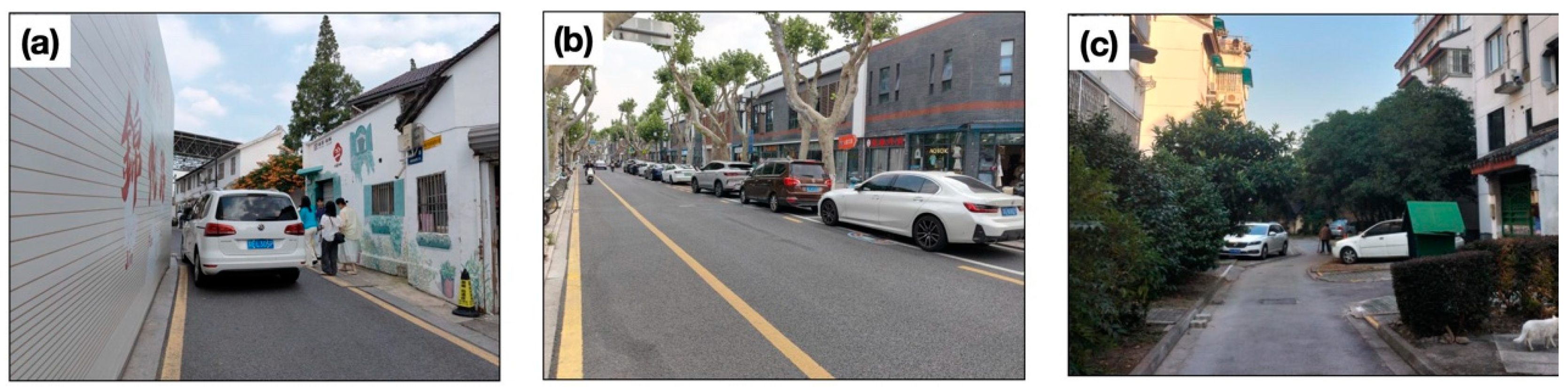
- Arterial Roads: For primary commuting corridors such as Ganjiang Road and Renmin Road (Figure 10b), the implementation of a time-variable lane allocation strategy is recommended. During peak hours, the existing traffic capacity should be maintained to ensure mobility, while, in off-peak periods, selected lanes can be dynamically repurposed as green buffers or pedestrian zones, thereby improving the streetscape quality. In addition, intelligent signal control systems should be deployed to optimize SAVs’ routing and ensure adaptability to fluctuating traffic conditions.
- Alleyways: In culturally sensitive alleyways (Figure 10d), motorized traffic should be strictly limited. Only low-speed SAVs (≤15 km/h) should be permitted, operating via subsurface optical guidance systems to enable minimally invasive navigation. This approach ensures the continuity of the pedestrian space while minimizing disruptions to the historical fabric and ambiance.
- Cultural Precincts: In core heritage zones, the establishment of zero-emission zones is advised. SAV transfer hubs should be located at the periphery to buffer the impact of motorized vehicles. Additionally, wayfinding systems should be enhanced using Suzhou-style aesthetic markers in place of standardized signage to ensure visual harmony with traditional cultural landscapes.
4.3. Limitations and Future Research Directions
- Data Source Limitations: The study relies primarily on in-depth interview data. While it captures residents’ multidimensional perceptions, it may not fully reflect the objective impacts of SAVs on the urban space—such as changes in traffic flow, parking turnover rates, or land use efficiency—which require further support from quantitative data and geospatial analytics.
- Sampling Bias: The findings may be subject to bias due to differences in respondents’ backgrounds, ages, and travel habits. Especially in the current phase, where SAVs have not been widely deployed, residents’ attitudes are largely shaped by hypothetical assumptions and subjective impressions, rather than lived experience.
- Technological Uncertainty: The research does not fully account for the dynamic nature of SAV technologies. Future breakthroughs in AI, changes in transportation policy, or shifts in social demand could significantly reshape the urban spatial landscape. Thus, the current conclusions may require adaptation over time.
- Geographical Specificity: The study focuses exclusively on Suzhou’s old town, whose historical, spatial, and demographic characteristics are unique. The generalizability of the findings to other cities or different urban typologies remains to be tested through comparative or multi-case research.
- Implementation Challenges: Given that SAV technologies are still in the developmental stages, real-world deployment may encounter a variety of complex challenges—including infrastructure retrofitting, legal and regulatory adaptation, and varying levels of market acceptance—which exceed the scope of this study.
5. Conclusions
Author Contributions
Funding
Institutional Review Board Statement
Informed Consent Statement
Data Availability Statement
Acknowledgments
Conflicts of Interest
Abbreviations
| AI | Artificial Intelligence |
| SAVs | Shared Autonomous Vehicles |
| IEEE | Institute of Electrical and Electronic Engineers |
| SAE | Society of Automotive Engineers |
| AVs | Autonomous Vehicles |
| V2X | Vehicle-to-Everything |
| VTT | Value of Travel Time |
| PAVs | Private Autonomous Vehicles |
| VKT | Vehicle Kilometers Traveled |
| XAI | Explainable Artificial Intelligence |
References
- Ji, L.; Zhang, W.; Sun, S. Urban spatial optimization and high-quality economic development: Empirical evidence based on district boundary reorganization. J. Finance Econ. 2023, 49, 4–18. [Google Scholar] [CrossRef]
- UN DESA. World Urbanization Prospects the 2018 Revision; United Nations Department of Economic and Social Affairs: New York, NY, USA, 2018. [Google Scholar]
- Wang, W.; Li, M.; Li, J.; Zhang, Y. Exploration on renewal and protection methods of historical and cultural cities: A case study of Suzhou CIM. Urban Dev. Stud. 2023, 30, 96–102. [Google Scholar]
- GB/T51328-2018; Standard for Urban Comprehensive Transport System Planning. CAUPD China Architecture & Building Press: Beijing, China, 2019.
- Suzhou Daily Suzhou Motor Vehicle Ownership Exceeded 5 Million. Available online: https://www.suzhou.gov.cn/szsrmzf/szyw/202210/3fc13e7b5b554fb289fddd9f7a34aa21.shtml (accessed on 21 March 2025).
- UITP. What Is the “New Normal” for Travel? UITP: Brussels, Belgium, 2023; pp. 1–12. [Google Scholar]
- Ipsos. Towards Zero Emissions Mobility: A Study on Urban Public Awareness, Behavior, and Drivers. 2022. Available online: https://www.efchina.org/Attachments/Report/report-comms-20220710/Towards-Zero-Emissions-Mobility-A-Study-on-Urban-Public-Awareness-Behavior-and-Drivers.pdf (accessed on 14 June 2025).
- Liu, P.; Zhang, N. Construction Path Exploration of Slow Driving System Based on Urban Material Space Characteristics. Available online: http://mp.weixin.qq.com/s?__biz=MzA3NTE1MjI5MA==&mid=2650850897&idx=2&sn=7e2ddfeb1ad89803751a75a7f2b4236c&chksm=854ef567013ac7fcb1f66b08e656e7551d85d743c34a9c8269e6e97532613c7a0335a12e1e46#rd (accessed on 21 March 2025).
- Stevens, P. Electric and Hybrid Vehicles Will Account for Nearly Half the Cars on the Road by 2040, Goldman Predicts. Available online: https://www.cnbc.com/2022/04/04/electric-and-hybrid-vehicles-will-account-for-nearly-half-the-cars-on-the-road-by-2040-goldman-predicts.html (accessed on 21 March 2025).
- Wang, W.; Zhu, J.; Zheng, S. The Characters of Urban Space in Automated Vehicle Era. Planners 2018, 34, 155–160. [Google Scholar]
- Shuttleworth, J. SAE Standards News: J3016 Automated-Driving Graphic Update. Available online: https://www.sae.org/site/news/2019/01/sae-updates-j3016-automated-driving-graphic (accessed on 24 March 2025).
- Zhang, W.; Chen, Y.; Jiang, Y. An Overview of the Impacts of Autonomous Vehicles on Urban Spatial Form. Urban Transp. China 2022, 20, 1–10. [Google Scholar] [CrossRef]
- Hawkins, J.; Nurul Habib, K. Integrated Models of Land Use and Transportation for the Autonomous Vehicle Revolution. Transp. Rev. 2019, 39, 66–83. [Google Scholar] [CrossRef]
- Narayanan, S.; Chaniotakis, E.; Antoniou, C. Shared Autonomous Vehicle Services: A Comprehensive Review. Transp. Res. Part C Emerg. Technol. 2020, 111, 255–293. [Google Scholar] [CrossRef]
- Nimish Biloria Autonomous Mobility in the Built Environment. In Intelligent Environments; North-Holland: Amsterdam, The Netherlands, 2023; pp. 351–394.
- Wikipedia. Old Town; Wikipedia: San Francisco, CA, USA, 2020. [Google Scholar]
- Wang, F.; Lv, Z.; Zhang, B.; Zhang, S.; Dong, W.; Liu, P.; Huang, Z.; Wu, B.; Lu, S.; Xu, F.; et al. Memory and homesickness in transition: Evolution mechanism and spatial logic of urban and rural memory. Geogr. Res. 2017, 36, 3–25. [Google Scholar]
- Yao, Y. Research on the Dilemma and Countermeasures of Urban Renewal in the Ancient City of Suzhou. Master’s Disseration, Soochow University, Suzhou, China, 2023. [Google Scholar]
- Li, S.; Sun, L. 2021 Urban Transport Travel Report: More Than 70% of Urban Residents’ Preferred Shared Travel Online Car Self-Driving or Bring Subversive Changes. Available online: https://www.nbd.com.cn/articles/2021-04-14/1696819.html (accessed on 26 March 2025).
- Stead, D.; Vaddadi, B. Automated Vehicles and How They May Affect Urban Form: A Review of Recent Scenario Studies. Cities 2019, 92, 125–133. [Google Scholar] [CrossRef]
- Ambühl, L.; Ciari, F.; Menendez, M. What About Space? A Simulation Based Assessment of AVs Impact on Road Space in Urban Areas. In Proceedings of the 16th Swiss Transport Research Conference, Ascona, Switzerland, 18–20 May 2016; pp. 1–9. [Google Scholar]
- Thakur, P.; Kinghorn, R.; Grace, R. Urban Form and Function in the Autonomous Era. In Proceedings of the 38th Australasian Transport Research Forum (ATRF 2016), Melbourne, Australia, 16–18 November 2016; ARRB: Victoria, Australia, 2016; pp. 1–15. [Google Scholar]
- Zhang, W.; Guhathakurta, S. Residential Location Choice in the Era of Shared Autonomous Vehicles. J. Plan. Educ. Res. 2018, 41, 135–148. [Google Scholar] [CrossRef]
- Stocker, A.; Shaheen, S. Shared Automated Vehicles: Review of Business Models; OECD: Paris, France, 2017; pp. 5–21. [Google Scholar]
- Yang, L.; Liang, Y.; Zhang, S.; Bai, J. Smart Street Design in the Era of Autonomous Driving: An Overview of Historical Evolution and Development Trends. Urban Plan. Int. 2024, 1–18. [Google Scholar] [CrossRef]
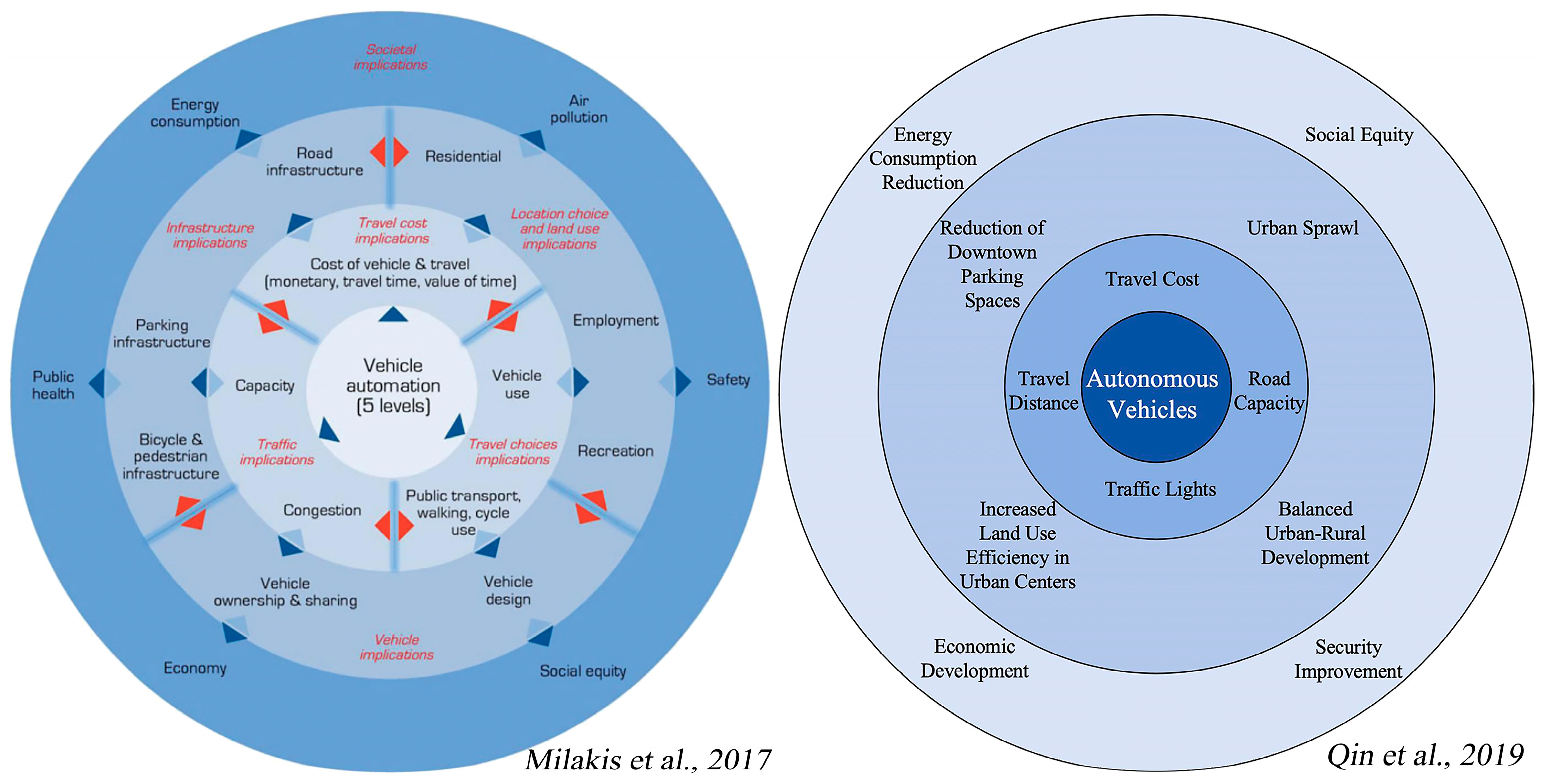
- Qin, B.; Chen, X.; Qu, S. The Impacts of Autonomous Vehicle on the Cities and Planning Responses: A Literature Review Based on Ripple Effect Model. Urban Plan. Int. 2019, 34, 108–114. [Google Scholar] [CrossRef]
- Milakis, D.; Van Arem, B.; Van Wee, B. Policy and Society Related Implications of Automated Driving: A Review of Literature and Directions for Future Research. J. Intell. Transp. Syst. 2017, 21, 324–348. [Google Scholar] [CrossRef]
- Katerinin, K.; Sanzhapov, B. Optimization of the Traffic Light Regulation Parameters on the Urban Road Network in Order to Minimize the Negative Environmental Impact. E3S Web Conf. 2019, 138, 1024. [Google Scholar] [CrossRef]
- He, Y.; Lin, H.; Liu, Y.; Yang, L.; Qu, X. Applications and Challenges of Reinforcement Learning. J. Tongji Univ. Sci. 2024, 52, 520–531. [Google Scholar] [CrossRef]
- Ou, J.; Wang, M. A study on the comprehensive evaluation and decision optimization of Suzhou old town capacity. City Plan. Rev. 2023, 47, 43–53. [Google Scholar]
- Yang, J.; Yang, Z. Adjustment and Optimization of the Carrying Capacity of the Ancient City of Suzhou for Social Sustainability. Urban Plan. Forum 2024, 283, 65–73. [Google Scholar] [CrossRef]
- Ruan, Y.; Liu, H. Gusu Xin Xu, 1st ed.; China Architecture & Building Press: Beijing, China, 2005. [Google Scholar]
- Suzhou Daily The 7th National Census Data of Suzhou City Was Released, and the Total Population, Population Increment and Growth Rate Were the First in the Province, The Number of Talents Accounted for the Second in the Province, and the Proportion of the Elderly Aged 65 and Above Was the Lowest in the Province. Available online: https://www.suzhou.gov.cn/szsrmzf/szyw/202105/d2f835220e41475da3cab680df16d7a2.shtml (accessed on 28 March 2025).
- Fan, L. Evolution and Reflection on Rural Planning of City-cluster Areas from the Perspective of Urban-rural Relationship: A Case Study of Suzhou. Urban Plan. Forum 2015, 6, 106–113. [Google Scholar] [CrossRef]
- Wandenkolk, I.; Winter, S.; Stetten, N.; Classen, S. Department of Veterans Affairs’ Transportation System: Stakeholder Perspectives on the Current and Future System, Including Electric Autonomous Ride-Sharing Services. World Electr. Veh. J. 2025, 16, 293. [Google Scholar] [CrossRef]
- Fu, X.; Nie, Q.; Liu, J.; Zhang, Z.; Jones, S. How Do College Students Perceive Future Shared Mobility with Autonomous Vehicles? A Survey of the University of Alabama Students. Int. J. Transp. Sci. Technol. 2022, 11, 189–204. [Google Scholar] [CrossRef]
- Etminani-Ghasrodashti, R.; Ketankumar Patel, R.; Kermanshachi, S.; Michael Rosenberger, J.; Weinreich, D.; Foss, A. Integration of Shared Autonomous Vehicles (SAVs) into Existing Transportation Services: A Focus Group Study. Transp. Res. Interdiscip. Perspect. 2021, 12, 100481. [Google Scholar] [CrossRef]
- Zhang, W.; Guhathakurta, S.; Fang, J.; Zhang, G. Exploring the Impact of Shared Autonomous Vehicles on Urban Parking Demand: An Agent-Based Simulation Approach. Sustain. Cities Soc. 2015, 19, 34–45. [Google Scholar] [CrossRef]
- Xia, B.; Wu, J.; Wang, J.; Fang, Y.; Shen, H.; Shen, J. Sustainable Renewal Methods of Urban Public Parking Spaces under the Scenario of Shared Autonomous Vehicles (SAV): A Review and a Proposal. Sustainability 2021, 13, 3629. [Google Scholar] [CrossRef]
- Gu, T.; Yang, X.; Jiang, W.; Yao, C.; Chen, S.; Tian, R. Supply-oriented demand control of private car use in central urban areas: An empirical study on typical cases. 2023, 1–15. [Google Scholar] [CrossRef]
- Heinrichs, D. Autonomous Driving and Urban Land Use. In Autonomous Driving; Maurer, M., Gerdes, J.C., Lenz, B., Winner, H., Eds.; Springer: Berlin/Heidelberg, Germany, 2016; pp. 213–231. ISBN 978-3-662-48845-4. [Google Scholar]
- Zhu, W.; Huang, W.; Yue, D.; Cheng, Y. Evaluation of Elderly-oriented Public Space Facilities in Old Neighborhoods. Packag. Eng. 2023, 44, 169–177, 200. [Google Scholar] [CrossRef]
- Viriyayudhakorn, K. Creativity Assistants and Social Influences in KJ-Method Creativity Support Groupware. Ph.D. Dissertation, Japan Advanced Institute of Science and Technology, Nomi, Japan, 2013. [Google Scholar]
- Huang, Z.; Yang, Z.; Liang, Y. Research on the Design of Public Facilities in Nandan Baiku Yao Scenic Area Based on Miryoku Engineering Theory. Packag. Eng. 2023, 44, 431–439. [Google Scholar] [CrossRef]
- Mason, M. Sample Size and Saturation in PhD Studies Using Qualitative Interviews. Forum Qual. Sozialforschung Forum Qual. Soc. Res. 2010, 11, 1–19. [Google Scholar] [CrossRef]
- SP Consulting The Market Size and Growth Trend of China’s Online Car Hailing in 2022. Available online: https://www.sohu.com/a/www.sohu.com/a/666196015_120245260 (accessed on 26 March 2025).
- National Bureau of Statistics How to Distinguish Between Permanent Residents and Floating Population? Available online: https://www.stats.gov.cn/zs/tjws/tjbz/202301/t20230101_1903796.html (accessed on 19 April 2025).
- Danilevičius, A.; Danilevičienė, I.; Karpenko, M.; Stosiak, M.; Skačkauskas, P. Determination of the Instantaneous Noise Level Using a Discrete Road Traffic Flow Method. Promet-Traffictransportation 2025, 37, 71–85. [Google Scholar] [CrossRef]
- Nazari, G.; Bobos, P.; MacDermid, J.C.; Birmingham, T. The Effectiveness of Instrument-Assisted Soft Tissue Mobilization in Athletes, Participants without Extremity or Spinal Conditions, and Individuals with Upper Extremity, Lower Extremity, and Spinal Conditions: A Systematic Review. Arch. Phys. Med. Rehabil. 2019, 100, 1726–1751. [Google Scholar] [CrossRef]
- Nyholm, S.; Smids, J. Automated Cars Meet Human Drivers: Responsible Human-Robot Coordination and the Ethics of Mixed Traffic. Ethics Inf. Technol. 2020, 22, 335–344. [Google Scholar] [CrossRef]
- Zmud, J.; Sener, I.N.; Wagner, J. Self-Driving Vehicles: Determinants of Adoption and Conditions of Usage. Transp. Res. Rec. J. Transp. Res. Board 2016, 2565, 57–64. [Google Scholar] [CrossRef]
- Zhong, X. From Algorithmic “ Black Box” to Algorithmic Transparency: A Dualistic Law Governance Model Based on “ Hard Law-Soft Law”. Chin. J. Marit. Law 2023, 34, 53–62. [Google Scholar]
- Bureau of Statistics of Gusu District Bulletin of the Seventh National Population Census of Gusu District. Available online: https://tjgb.hongheiku.com/12035.html (accessed on 29 April 2025).
- The Paper The Permanent Resident Population of Suzhou Increased by 47,400 Last Year, and the Total Number Continued to Rank First in Jiangsu Province. Available online: https://baijiahao.baidu.com/s?id=1793569016472174704&wfr=spider&for=pc (accessed on 29 April 2025).
- Fagnant, D.J.; Kockelman, K. Preparing a Nation for Autonomous Vehicles: Opportunities, Barriers and Policy Recommendations. Transp. Res. Part Policy Pract. 2015, 77, 167–181. [Google Scholar] [CrossRef]
- Millard-Ball, A. The Autonomous Vehicle Parking Problem. Transp. Policy 2019, 75, 99–108. [Google Scholar] [CrossRef]
- Karpenko, M.; Prentkovskis, O.; Skačkauskas, P. Analysing the Impact of Electric Kick-Scooters on Drivers: Vibration and Frequency Transmission during the Ride on Different Types of Urban Pavements. Eksploat. Niezawodn.—Maint. Reliab. 2025, 27, 2025. [Google Scholar] [CrossRef]
- Ma, H. Research on the Development and Evolution of Urban Renewal in China Based on Periodical Literature Statistics. Master’s Thesis, Xian University of Architecture and Technology, Xi’an, China, 2022. [Google Scholar]


| Interviewee ID | Gender | Age | Driver’s License | Years of Residence in Suzhou |
|---|---|---|---|---|
| 1 | Male | 22 | Yes | 3 |
| 2 | Male | 31 | Yes | 31 |
| 3 | Male | 24 | Yes | 4 |
| 4 | Male | 26 | No | 3 |
| 5 | Female | 21 | Yes | 20 |
| 6 | Female | 35 | No | 13 |
| 7 | Male | 32 | Yes | 7 |
| 8 | Female | 40 | Yes | 17 |
| 9 | Female | 34 | Yes | 8 |
| 10 | Male | 38 | Yes | 10 |
| 11 | Male | 43 | Yes | 31 |
| 12 | Female | 51 | Yes | 23 |
| 13 | Female | 28 | Yes | 10 |
| 14 | Male | 36 | Yes | 11 |
| 15 | Female | 55 | Yes | 40 |
| 16 | Male | 26 | Yes | 2 |
| 17 | Female | 61 | Yes | 61 |
| 18 | Female | 31 | Yes | 5 |
| 19 | Female | 52 | Yes | 35 |
| 20 | Male | 46 | Yes | 20 |
| 21 | Female | 31 | Yes | 31 |
| 22 | Male | 29 | Yes | 0.6 |
| 23 | Male | 40 | Yes | 30 |
| 24 | Male | 35 | Yes | 10 |
| 25 | Female | 33 | Yes | 8 |
| 26 | Female | 29 | Yes | 4 |
| 27 | Male | 37 | Yes | 37 |
| Category | Type | Number of Participants | Percentage (%) |
|---|---|---|---|
| Gender | Male | 14 | 52 |
| Female | 13 | 48 | |
| Age | 18–24 years | 3 | 11 |
| 25–29 years | 6 | 22 | |
| 30–39 years | 10 | 37 | |
| 40–49 years | 4 | 15 | |
| 50 years and above | 4 | 15 | |
| Driver’s License | Yes | 25 | 93 |
| No | 2 | 7 | |
| Years of Residence in Suzhou | 0.6–5 years | 7 | 26 |
| 6–10 years | 6 | 22 | |
| 11 years and above | 14 | 52 |
| Interview Theme | Interview Questions | Key Information |
|---|---|---|
| Basic Perceptions | If more SAVs were introduced into the city, would you be more inclined to use them? Why? | “Convenient travel; safety; lack of human interaction; flexible drop-off points; reduced traffic congestion; acceptable when not in a hurry; affordable pricing; sufficient time available; ability to handle emergencies; will not be the main mode of travel; unknown risks; lack of trust in autonomous driving; technological maturity concerns; no risk of collisions; no parking required; no social interaction needed; inability to get off in safe zones; AVs stopping in the middle of the road; system crashes; older adults’ slower reactions; responsibility in accidents; route optimization; system failure.” |
| Residential Preferences | Do you think the development of SAVs will influence your residential choices (e.g., city center vs. suburban)? Why? | “Housing prices; residential environment; partial population shift to suburbs; no immediate change but potential in the future; stronger correlation with income level; convenience for work–life balance; suburban quietness; improved non-driving mobility; SAVs as an additional travel option; preference for vibrant old town; older people preferring suburbs; urban congestion in old town; SAVs are only one factor among many; living environment and commuting convenience are primary factors.” |
| Parking Space | Will the widespread use of SAVs reduce the urban demand for parking spaces? Why? | “No reduction in short term; more cars with rising living standards; reasonable drop-off locations may reduce demand; parking space function changes with traffic flow; same number of vehicles means same demand; resource efficiency; reduction in private car ownership; people still prefer driving; central areas still need parking due to high foot traffic; SAVs are just one more option.” |
| If the parking demand decreases, how would you prefer parking land to be repurposed? | “Outdoor fitness areas; parks and public sports spaces; children’s playgrounds; urban green space; open spaces; pocket parks.” | |
| In your opinion, will SAVs change the layout of existing parking facilities? | “Compact parking spaces; conflict between SAVs and private vehicle parking; dedicated parking for AVs; reduced space demand when technology matures; skeptical due to past bike-sharing experience; intelligent vehicle control increases spatial efficiency; local adjustments first; concentrated vertical parking; simplified parking layouts.” | |
| Accessibility | Will the development of SAVs improve accessibility in certain areas? Which areas might see the most improvement? | “Improved access to remote and suburban residential areas; better access to transportation hubs (airports, stations); increased short-trip accessibility; suburban parks and green areas; non-central tourist attractions; sports centers; shopping malls; during peak congestion; scenic spots in outskirts; locations with limited parking; old towns and one-way streets; narrow spaces only small vehicles can enter.” |
| If SAVs improve accessibility, what impact would you expect on the distribution of commercial, residential, or public facilities? | “Polycentric urban development; centralized medical and commercial areas; easier return after drinking in dining spaces; SAVs reduce pressure in crowded areas; walkable access between residential and public service areas; commercial areas close yet slightly separated from residential zones; no expected change; mixed-use redevelopment after removing parking; lower FAR in residential zones; denser commercial areas; expectation for more livable environments.” | |
| Do you think SAVs will affect the ease of travel to city attractions? Will it change your travel plans? Why? | “Easier access to various attractions; better for short-distance connections from train/bus stations; increased preference for short trips; extended service range for inter-city commutes; nighttime mobility supplement; earlier departures needed; improved acceptance of remote destinations; reduced wait times; lower long-distance driving burden; some hesitation; more convenient; safety concerns; parking no longer a concern; can visit more places in one day; cost-effective; higher travel frequency; flexible route planning.” | |
| Street Infrastructure and Environment | Will the popularity of SAVs alter the design of urban streets? | “Wider sidewalks, more greenery, better signage, more cyclists; SAVs compress road space; concern for maintaining traditional street structure; streets should serve people, SAVs can’t replace traditional vehicles; improved urban environment; narrower roads with more green spaces; dispersed urban living, wider lanes, greener cities; dedicated lanes for SAVs (including shared taxis and buses); enlarged scale.” |
| What aspects of the street environment would you like SAVs to improve? | “Electric vehicles improve air quality; safety is the top priority, followed by noise and air pollution; most important is safety; noise reduction and safety; safety, speed, noise; reduced congestion, improved safety, optimized street space.” | |
| If traffic accidents decrease due to SAVs, what changes might occur in street infrastructure? | “Facilities shift from controlling vehicles to pedestrians and bikes; simplified signage; infrastructure remains due to mixed traffic; digital sensing systems aid AVs; no change; fewer barriers; more pedestrian space, fewer barriers; mixed traffic remains, limited change; decorative signage replaces standard signs; more landmarks; fewer traffic lights; flexible lights for low-traffic zones; not complete removal but reduction of guardrails and signals.” | |
| What changes might occur in the urban traffic layout as SAVs develop? | “Pick-up/drop-off zones near residential/offices; smaller bus stops replaced by AV stops; more pick-up/drop-off points in high-density areas; SAVs and shared public transport have independent road networks; SAVs and private vehicles separated; no reduction in traditional bus stops; some parking spaces repurposed; AVs replace certain stop areas; public transit remains essential; AV drop-off points need universal accessibility; centralized parking and charging hubs; enhance accessibility of old towns.” | |
| Open-Ended Perspectives | Do you have other thoughts or suggestions on how SAVs might reshape the urban space? | “Upgraded parking, fueling, and charging facilities; mixed feelings: interest and spatial concerns; more human-centered facilities; large events should be moved out of city centers to avoid congestion; more dense drop-off points but maintain aesthetic appeal; ensure passenger safety and accurate routing; more public amenities; avoid school zone congestion during peak hours; reduce parking lots, increase green spaces; strong anticipation; dedicated lanes; safety is key; increase spatial efficiency.” |
| Source (Key Information) | Target (Index) | Value (Word Frequency) |
|---|---|---|
| Age, | Residential convenience of travel | 4 |
| SAV infrastructure | 2 | |
| efficiency | 2 | |
| Economic | Residential prices | 2 |
| Living environment | Residential environment | 8 |
| Accessibility of residents | Accessibility of residential areas | 6 |
| Parking space | Availability of parking spaces | 14 |
| Sports areas, outside areas | Urban fitness spaces | 5 |
| More green space, pocket parks | Parks and green spaces | 7 |
| Living environment | 2 | |
| Aesthetic signs | Aesthetic and personalized design of transportation facilities | 2 |
| Traffic barriers | Number of traffic barriers and traffic lights in old town | 8 |
| Pick-up and drop-off points | Density of pick-up and drop-off points in old town | 6 |
| Facilities | Density of public transport stops in old town | 9 |
| Barrier-free facilities | Barrier-free transportation facilities in old town | 2 |
| Facilities | 2 | |
| SAV infrastructure | Density of gasoline and charging stations | 2 |
| Transport environment | Air quality and noise | 4 |
| More green space, pocket parks | 2 | |
| Cost | Travel cost | 4 |
| Economic | 2 | |
| Unsafety, risk, travel in the evening | Travel safety | 14 |
| Social and emotional | Social needs during travel | 6 |
| Efficiency | Travel efficiency | 17 |
| Suburban scenic spots | Accessibility to suburban scenic spots | 2 |
| Hubs | Accessibility to transportation hubs | 6 |
| Sports areas | Accessibility to cultural and sports spaces for residents | 4 |
| Restaurants, business areas | Comprehensive accessibility in old town | 7 |
| Suburban scenic spots | 2 | |
| Hubs | 2 | |
| Sports areas | 2 | |
| Accessibility of residents | 2 | |
| Total | 159 | |
| Objective (A) | Criterion Layer (B) | Index Layer (C) |
|---|---|---|
| A1. The Living Environment, Travel Experience and Spatial Quality Demands of the Residents in the Old Town | B1. Influencing Factors of Residential Area Selection | C1. Residential Convenience of Travel |
| C2. Residential Prices | ||
| C3. Residential Environment | ||
| C4. Accessibility of Residential Areas | ||
| B2. The Daily Functional Space Requirements of the Old Town | C5. Availability of Parking Spaces | |
| C6. Urban Fitness Spaces | ||
| C7. Parks and Green Spaces | ||
| B3. Perceptions of Environmental Quality of Traffic Spaces in Old Town | C8. Aesthetic and Personalized Design of Transportation Facilities | |
| C9. Number of Traffic Barriers and Traffic Lights in Old Town | ||
| C10. Density of Pick-Up and Drop-Off Points in Old Town | ||
| C11. Density of Public Transport Stops in Old Town | ||
| C12. Barrier-Free Transportation Facilities in Old Town | ||
| C13. Density of Gasoline and Charging Stations | ||
| C14. Air Quality and Noise | ||
| B4. Dimension of SAV Service Quality | C15. Travel Cost | |
| C16. Travel Safety (including vehicle driving safety, the safety of women using vehicles at night, and the risk of scratches on SAVs, etc.) | ||
| C17. Social Needs During Travel (non-carpooling SAV services can reduce contact with strangers, including unfamiliar passengers and drivers, and are more appealing to taxi-hailing users who have a fear of strangers) | ||
| C18. Travel Efficiency (including being able to hail a vehicle quickly and not refusing to pick up passengers in remote areas, etc.) | ||
| B5. The Accessibility Requirements of Multi-Functional Urban Spaces | C19. Accessibility to Suburban Scenic Spots | |
| C20. Accessibility to Transportation Hubs | ||
| C21. Accessibility to Cultural and Sports Spaces for Residents | ||
| C22. Comprehensive Accessibility in Old Town |
Disclaimer/Publisher’s Note: The statements, opinions and data contained in all publications are solely those of the individual author(s) and contributor(s) and not of MDPI and/or the editor(s). MDPI and/or the editor(s) disclaim responsibility for any injury to people or property resulting from any ideas, methods, instructions or products referred to in the content. |
© 2025 by the authors. Published by MDPI on behalf of the World Electric Vehicle Association. Licensee MDPI, Basel, Switzerland. This article is an open access article distributed under the terms and conditions of the Creative Commons Attribution (CC BY) license (https://creativecommons.org/licenses/by/4.0/).
Share and Cite
Yao, S.; Budthimedhee, K.; Teeravarunyou, S.; Chen, X.; Zhang, Z. Bidirectional Adaptation of Shared Autonomous Vehicles and Old Towns’ Urban Spaces: The Views of Residents on the Present. World Electr. Veh. J. 2025, 16, 395. https://doi.org/10.3390/wevj16070395
Yao S, Budthimedhee K, Teeravarunyou S, Chen X, Zhang Z. Bidirectional Adaptation of Shared Autonomous Vehicles and Old Towns’ Urban Spaces: The Views of Residents on the Present. World Electric Vehicle Journal. 2025; 16(7):395. https://doi.org/10.3390/wevj16070395
Chicago/Turabian StyleYao, Sucheng, Kanjanee Budthimedhee, Sakol Teeravarunyou, Xinhao Chen, and Ziqiang Zhang. 2025. "Bidirectional Adaptation of Shared Autonomous Vehicles and Old Towns’ Urban Spaces: The Views of Residents on the Present" World Electric Vehicle Journal 16, no. 7: 395. https://doi.org/10.3390/wevj16070395
APA StyleYao, S., Budthimedhee, K., Teeravarunyou, S., Chen, X., & Zhang, Z. (2025). Bidirectional Adaptation of Shared Autonomous Vehicles and Old Towns’ Urban Spaces: The Views of Residents on the Present. World Electric Vehicle Journal, 16(7), 395. https://doi.org/10.3390/wevj16070395