
Secondary Forest and Shrubland Dynamics in a Highly Transformed Landscape in the Northern Andes of Colombia (1985–2015)


Abstract
:1. Introduction
- (i)
- To map forest and shrub land using multi-temporal multispectral medium resolution satellite data covering 30 years.
- (ii)
- To quantify land cover change and fragmentation patterns for different types of vegetation.
- (iii)
- To identify the major environmental correlates of land-cover changes over time.
2. Materials and Methods
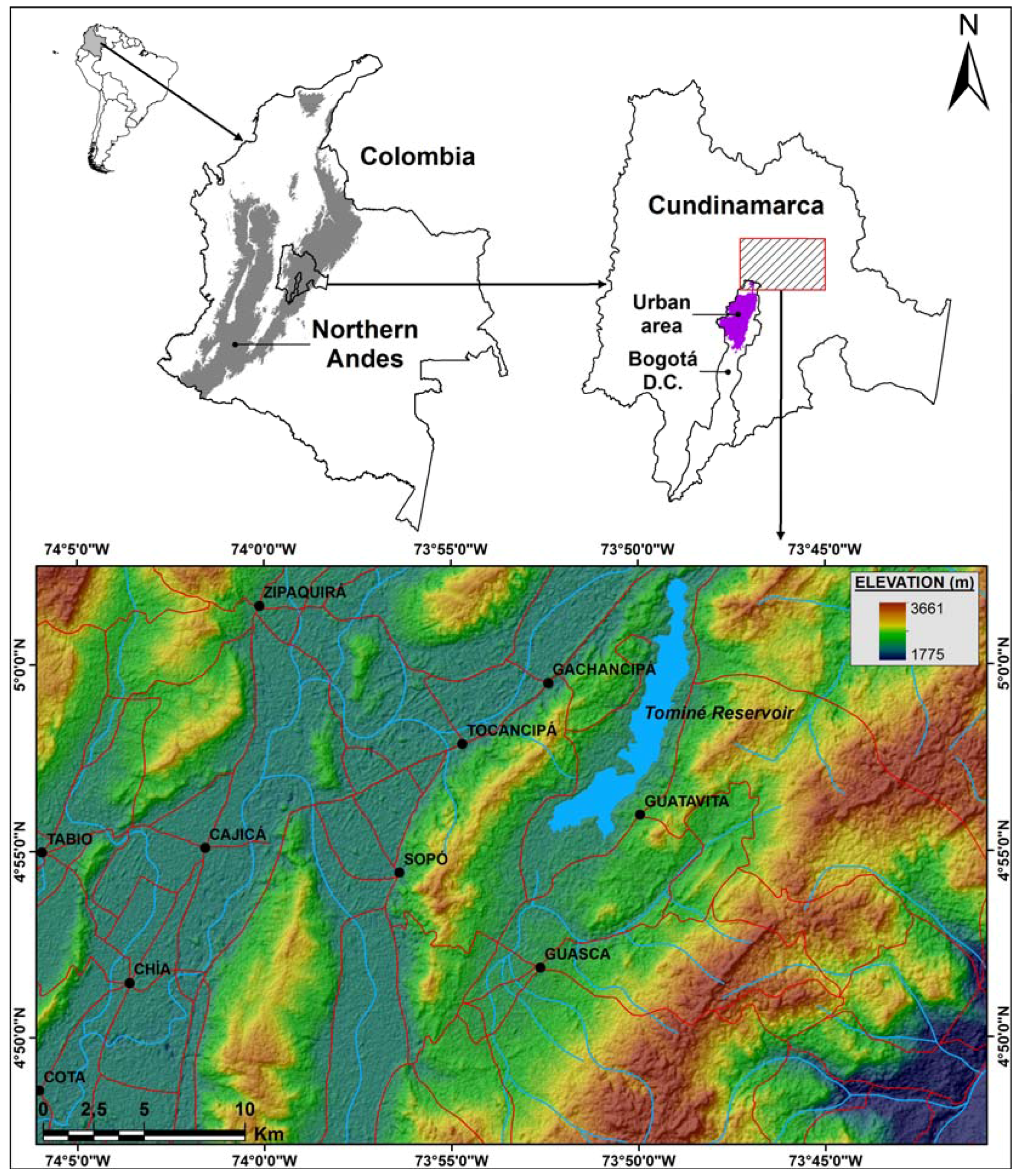
2.1. Study Area
2.2. Vegetation Cover Mapping
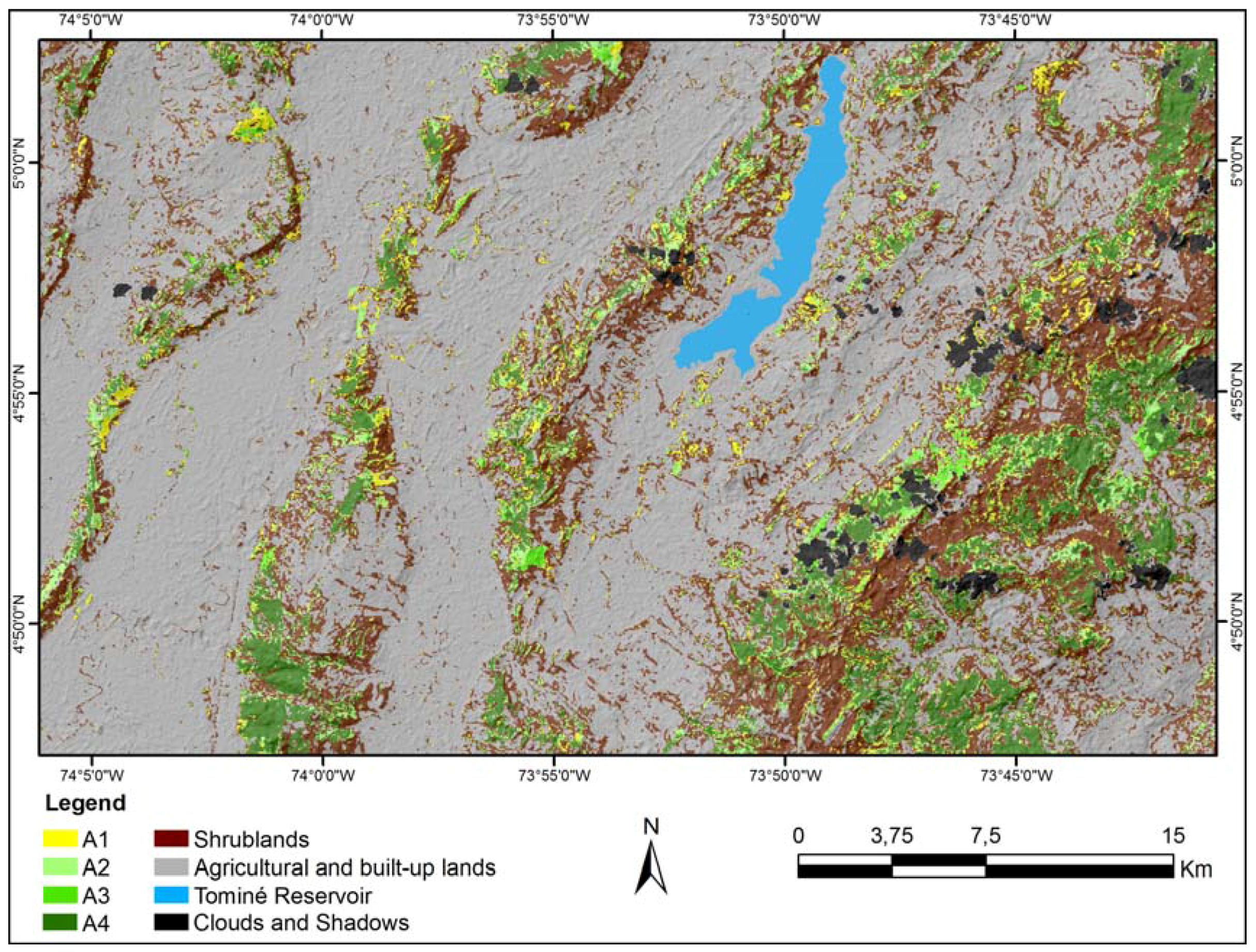
2.3. Landscape Change Analysis
- -
- A4: ≥30 years of presence.
- -
- A3: 24–30 years.
- -
- A2: 14–24 years.
- -
- A1: ≤14 years.
2.4. Geographical Factors and Change
3. Results
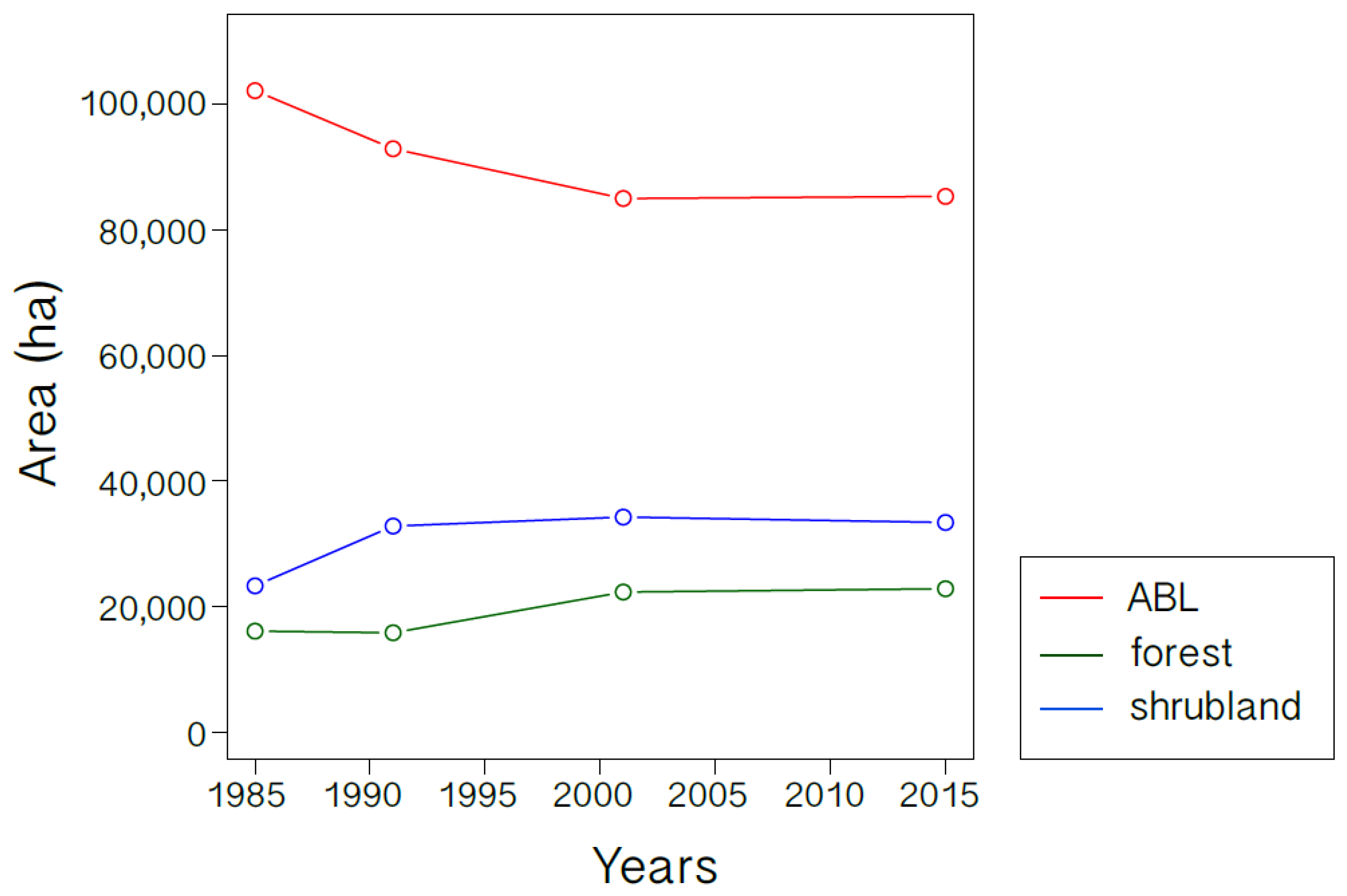
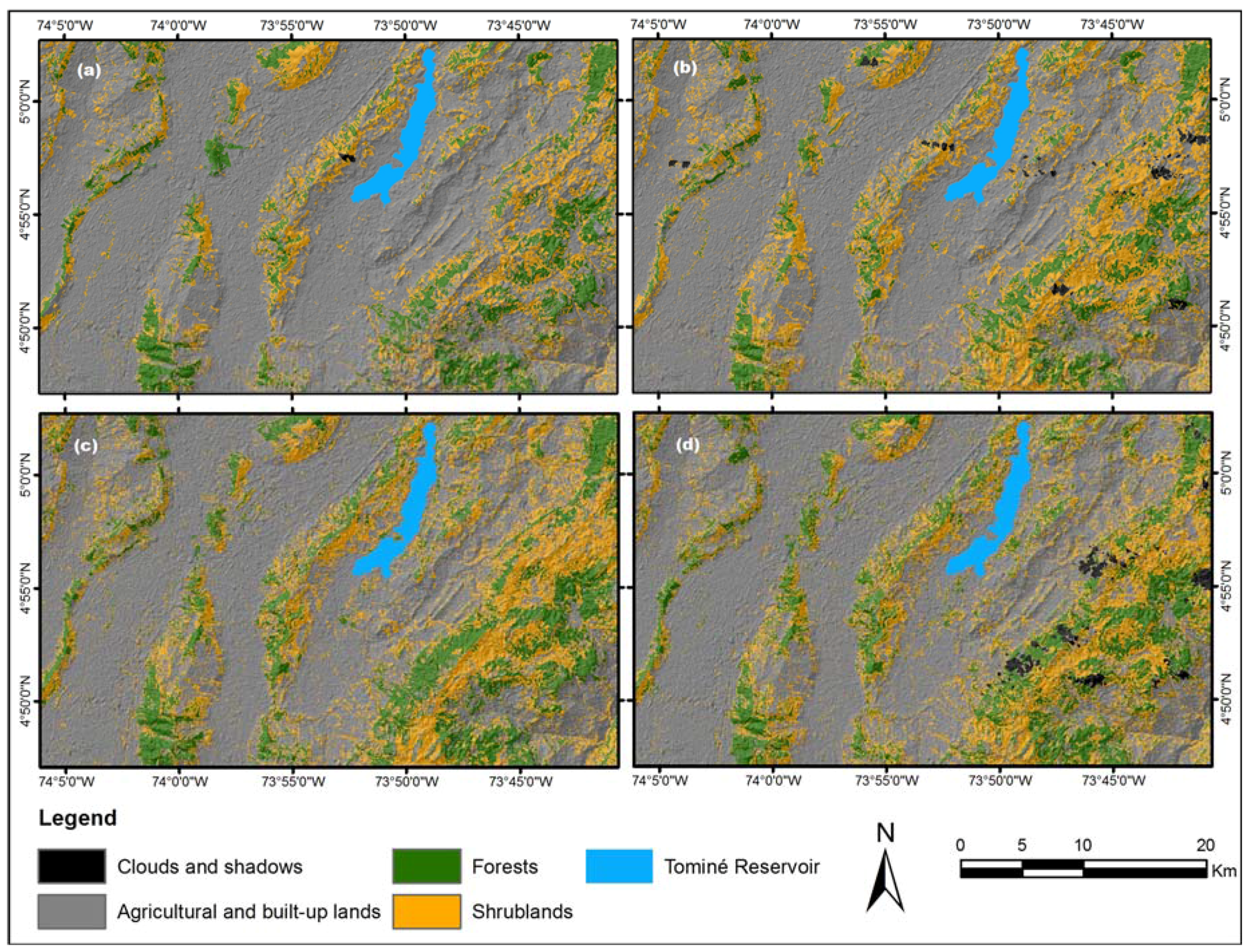
3.1. Land Cover Change Analysis
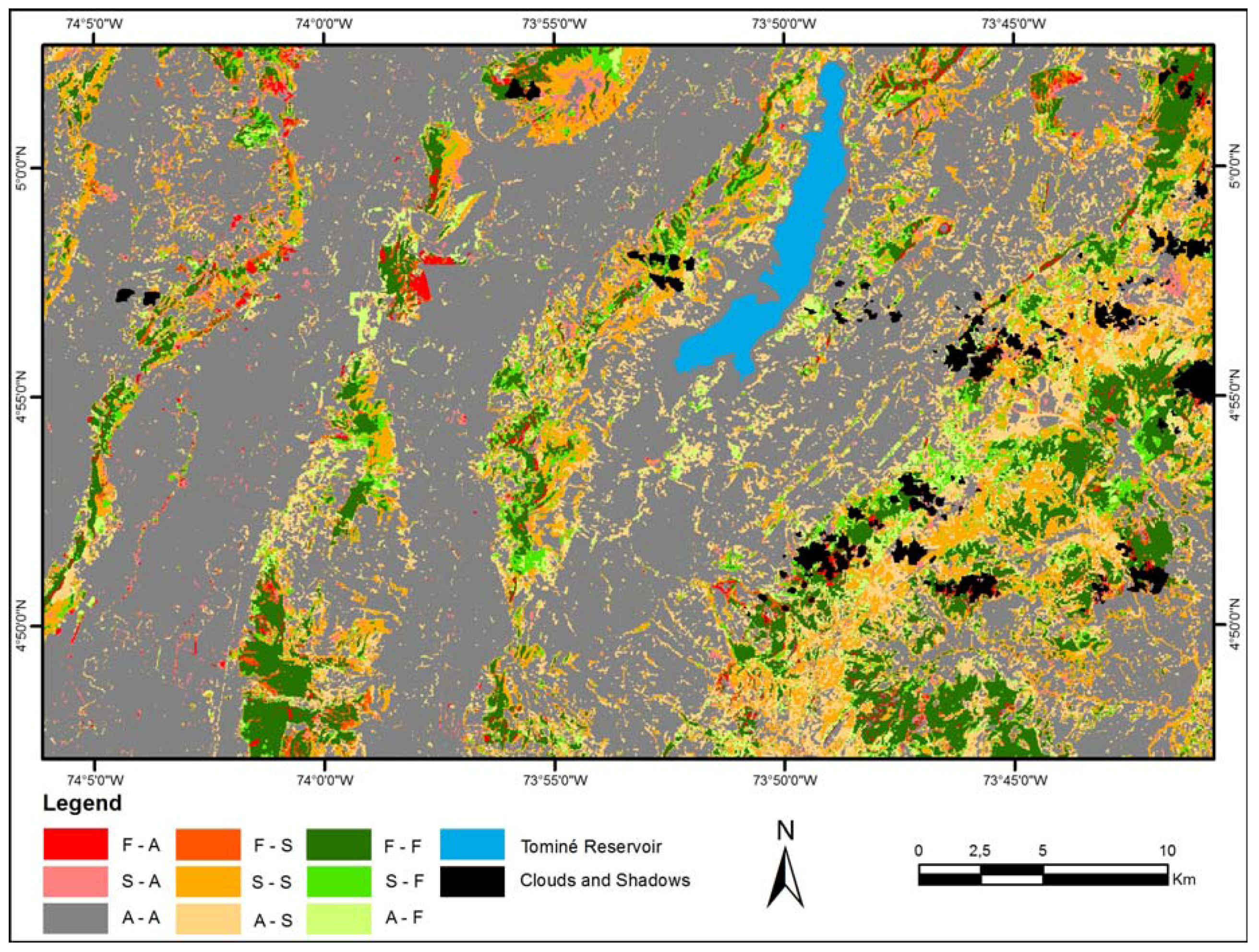
3.2. Patterns of Landscape Change
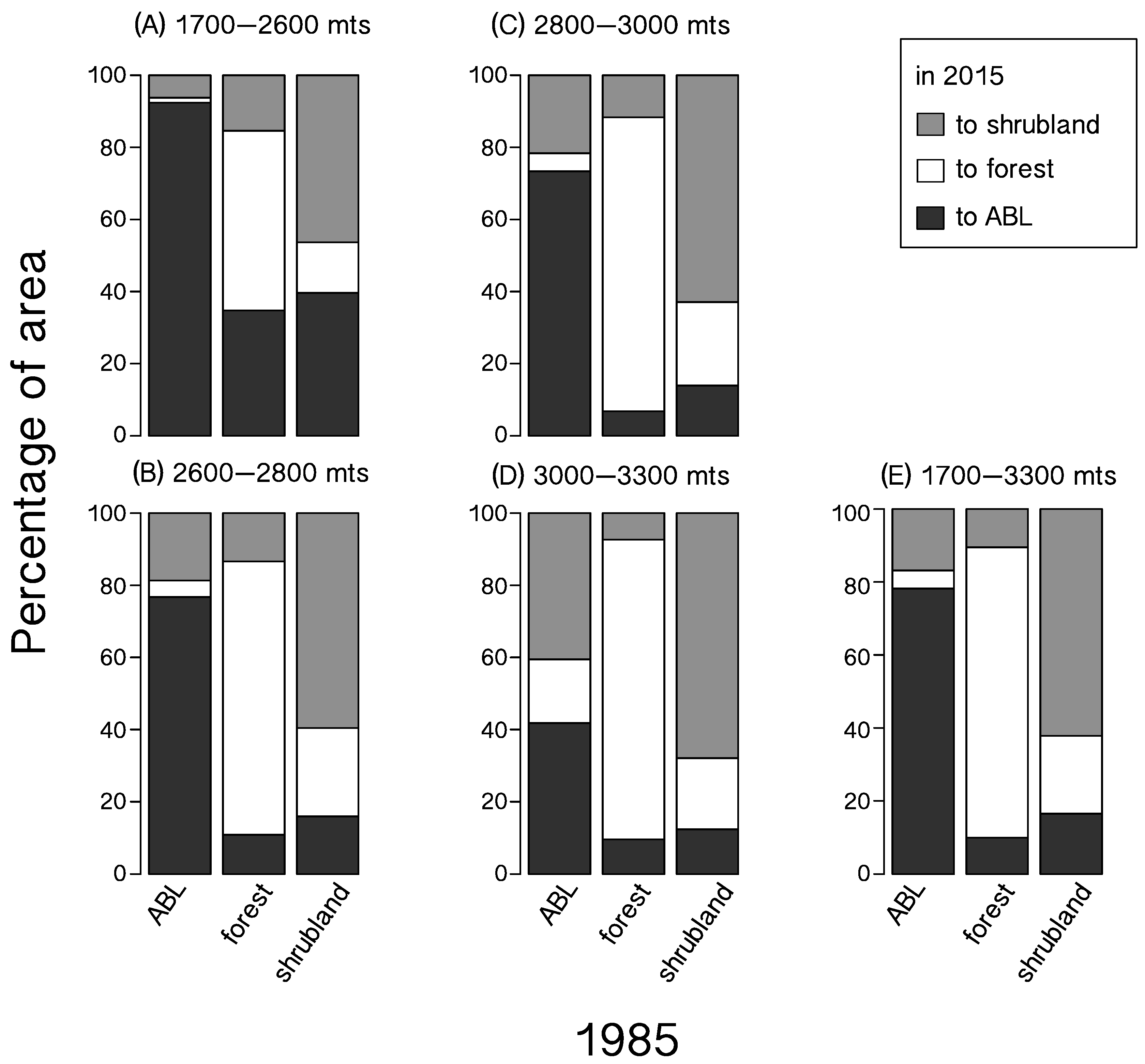
3.3. Landscape Change Correlates
4. Discussion
5. Conclusions
Supplementary Materials
Acknowledgments
Author Contributions
Conflicts of Interest
References
- Roberts, L. 9 Billion? Science 2011, 333, 540–543. [Google Scholar] [CrossRef] [PubMed]
- Grimm, N.B.; Faeth, S.H.; Golubiewski, N.E.; Redman, C.L.; Wu, J.; Bai, X.; Briggs, J.M. Global change and the ecology of cities. Science 2008, 319, 756–760. [Google Scholar] [CrossRef] [PubMed]
- Lambin, E.F.; Geist, H.J. Land-Use and Land-Cover Change: Local Processes and Global Impacts; Springer: Berlin, Germany, 2006. [Google Scholar]
- Foley, J.A.; DeFries, R.; Asner, G.P.; Barford, C.; Bonan, G.; Carpenter, S.R.; Chapin, F.S.; Coe, M.T.; Daily, G.C.; Gibbs, H.K.; et al. Global consequences of land use. Science 2005, 309, 570–574. [Google Scholar] [CrossRef] [PubMed]
- Lambin, E.F.; Geist, H.J.; Lepers, E. Dynamics of land-use and land-cover change in tropical regions. Annu. Rev. Environ. Resour. 2003, 28, 205–241. [Google Scholar] [CrossRef]
- Millennium Ecosystem Assessment. Ecosystems and Human Well-Being: Synthesis; Island Press: Washington, DC, USA, 2005. [Google Scholar]
- Vitousek, P.M.; Mooney, H.A.; Lubchenco, J.; Melillo, J.M. Human domination of Earth’s ecosystems. Science 1997, 277, 494–499. [Google Scholar] [CrossRef]
- Intergovernmental Panel on Climate Change (IPCC). Climate Change 2013: The Physical Science Basis. Contribution of Working Group I to the Fifth Assessment Report of the Intergovernmental Panel on Climate Change, 1st ed.; Cambridge University Press: New York, NY, USA, 2013. [Google Scholar]
- Mahmood, R.; Pielke, R.A.; Hubbard, K.G.; Niyogi, D.; Dirmeyer, P.A.; McAlpine, C.; Carleton, A.M.; Hale, R.; Gameda, S.; Beltrán-Przekurat, A.; et al. Land cover changes and their biogeophysical effects on climate. Int. J. Climatol. 2014, 34, 929–953. [Google Scholar] [CrossRef]
- Uriarte, M.; Schneider, L.; Rudel, T.K. Synthesis: Land transitions in the tropics. Biotropica 2010, 42, 59–62. [Google Scholar] [CrossRef]
- Orme, C.D.L.; Davies, R.G.; Burgess, M.; Eigenbrod, F.; Pickup, N.; Olson, V.A.; Webster, A.J.; Ding, T.-S.; Rasmussen, P.C.; Ridgely, R.S.; et al. Global hotspots of species richness are not congruent with endemism or threat. Nature 2005, 436, 1016–1019. [Google Scholar] [CrossRef] [PubMed]
- Grau, H.R.; Aide, T.M. Globalization and land-use transitions in Latin America. Ecol. Soc. 2008, 13, 16–27. [Google Scholar] [CrossRef]
- Ahmed, S.E.; Souza, C.M., Jr.; Ribeiro, J.; Ewers, R.M. Temporal patterns of road network development in the Brazilian Amazon. Reg. Environ. Chang. 2013, 13, 927–937. [Google Scholar] [CrossRef]
- Fraser, B. Deforestation: Carving up the Amazon. Nature 2014, 509, 418–419. [Google Scholar] [CrossRef] [PubMed]
- Achard, F.; Eva, H.D.; Stibig, H.-J.; Mayaux, P.; Gallego, J.; Richards, T.; Malingreau, J.-P. Determination of deforestation rates of the world's humid tropical forests. Science 2002, 297, 999–1002. [Google Scholar] [CrossRef] [PubMed]
- Achard, F.; Beuchle, R.; Mayaux, P.; Stibig, H.-J.; Bodart, C.; Brink, A.; Carboni, S.; Descleé, B.; Donnay, F.; Eva, H.D.; et al. Determination of tropical deforestation rates and related carbon losses from 1990 to 2010. Glob. Chang. Biol. 2014, 20, 2540–2554. [Google Scholar] [CrossRef] [PubMed]
- Laurance, W.F. Have we overstated the tropical biodiversity crisis? Trends Ecol. Evol. 2007, 22, 65–70. [Google Scholar] [CrossRef] [PubMed]
- Salazar, A.; Baldi, G.; Hirota, M.; Syktus, J.; McAlpine, C. Land use and land cover change impacts on the regional climate of non-Amazonian South America: A review. Glob. Planet. Chang. 2015, 128, 103–119. [Google Scholar] [CrossRef]
- Hansen, M.C.; Potapov, P.V.; Moore, R.; Hancher, M.; Turubanova, S.A.; Tyukavina, A.; Thau, D.; Stehman, S.V.; Goetz, S.J.; Loveland, T.R.; et al. High-Resolution Global Maps of 21st-Century Forest Cover Change. Science 2013, 342, 850–853. [Google Scholar] [CrossRef] [PubMed]
- Myers, N.; Mittermeier, R.A.; Mittermeier, C.G.; da Fonseca, G.A.B.; Kent, J. Biodiversity hotspots for conservation priorities. Nature 2000, 403, 853–858. [Google Scholar] [CrossRef] [PubMed]
- Romero, M.; Cabrera, E.; Ortiz, N. Informe Sobre el Estado de la Biodiversidad en Colombia 2006–2007; Instituto de Investigación de Recursos Biólogicos Alexander von Humboldt: Bogotá D.C., Colombia, 2008. [Google Scholar]
- Etter, A.; van Wyngaarden, W. Patterns of landscape transformation in Colombia, with emphasis in the Andean region. AMBIO 2000, 29, 432–439. [Google Scholar] [CrossRef]
- Cavelier, J.; Etter, A. Deforestation of montane forests in Colombia as a result of illegal opium plantations (Papaver somniferum). In Biodiversity and Conservation of Neotropical Montane Forests; Churchill, S.P., Balslev, H., Forero, E., Luteyn, J.L., Eds.; The New York Botanical Garden: New York, NY, USA, 1995; pp. 541–550. [Google Scholar]
- Chadid, M.A.; Dávalos, L.M.; Molina, J.; Armenteras, D. A Bayesian Spatial Model Highlights Distinct Dynamics in Deforestation from Coca and Pastures in an Andean Biodiversity Hotspot. Forests 2015, 6, 3828–3846. [Google Scholar] [CrossRef]
- Sánchez-Cuervo, A.M.; Aide, T.M. Consequences of the armed conflict, forced human displacement, and land abandonment on forest cover change in Colombia: A multi-scale analysis. Ecosystems 2013, 16, 1052–1070. [Google Scholar] [CrossRef]
- Etter, A.; McAlpine, C.; Possingham, H. Historical patterns and drivers of landscape change in Colombia since 1500: A regionalized spatial approach. Ann. Assoc. Am. Geogr. 2008, 98, 2–23. [Google Scholar] [CrossRef]
- Mendoza, J.E.; Etter, A. Multitemporal analysis (1940–1996) of land cover changes in the southwestern Bogotá High-plain. Landsc. Urban Plan. 2002, 59, 147–158. [Google Scholar] [CrossRef]
- Sánchez-Cuervo, A.M.; Aide, T.M.; Clark, M.L.; Etter, A. Land Cover Change in Colombia: Surprising Forest Recovery Trends between 2001 and 2010. PLoS ONE 2012, 7, e43943. [Google Scholar] [CrossRef] [PubMed]
- Norden, N.; Chazdon, R.L.; Chao, A.; Jiang, Y.-H.; Vílchez-Alvarado, B. Resilience of tropical rain forests: Tree community reassembly in secondary forests. Ecol. Lett. 2009, 12, 385–394. [Google Scholar] [CrossRef] [PubMed]
- Departamento Administrativo Nacional de Estadística (DANE). Available online: http://www.dane.gov.co/ (accessed on 15 October 2015).
- Secretaría Distrital de Planeación. Región Metropolitana de Bogotá: Una Visión de la Ocupación del Suelo; Alcaldía Mayor de Bogotá D.C.: Bogotá D.C., Colombia, 2014.
- Etter, A.; Villa, L.A. Andean forest and farming systems in part of the eastern cordillera (Colombia). Mt. Res. Dev. 2000, 20, 236–245. [Google Scholar] [CrossRef]
- Antonio-Fragala, F.; Obregón-Neira, N. Recharge estimation in aquifers of the Bogotá Savannah. Ing. Univ. 2011, 15, 145–169. [Google Scholar]
- Saldarriaga, A. Hubo una vez una Sabana: Aproximación al Estudio de la Transformación de la Sabana de Bogotá; Instituto Geográfico Agustín Codazzi: Bogotá D.C., Colombia, 1974.
- Van der Hammen, T. La sabana de Bogotá y su lago en el Pleniglacial Medio. Caldasia 1986, 15, 249–262. [Google Scholar]
- Cortés-S, S.P.; Van der Hammen, T.; Rangel-Ch, J.O. Comunidades vegetales y patrones de degradación y sucesión en la vegetación de los Cerros Occidentales de Chía-Cundinamarca-Colombia. Rev. Acad. Colomb. Cienc. 1999, 23, 529–554. [Google Scholar]
- Van der Hammen, T. Plan Ambiental de la Cuenca Alta del río Bogotá: Análisis y Orientación Para el Ordenamiento Territorial; CAR: Bogotá D.C., Colombia, 1998. [Google Scholar]
- United States Geological Survey. USGS Global Visualization Viewer. Available online: http://glovis.usgs.gov/ (accessed on 3 August 2015).
- Chander, G.; Markham, B.L.; Helder, D.L. Summary of current radiometric calibration coefficients for Landsat MSS, TM, ETM+, and EO-1 ALI sensors. Remote Sens. Environ. 2009, 113, 893–903. [Google Scholar] [CrossRef]
- Berk, A.; Bernstein, L.S.; Anderson, G.P.; Acharya, P.K.; Robertson, D.C.; Chetwynd, J.H.; Adler-Golden, S.M. MODTRAN Cloud and Multiple Scattering Upgrades with Application to AVIRIS. Remote Sens. Environ. 1998, 65, 367–375. [Google Scholar] [CrossRef]
- Matthew, M.W.; Addler-Golden, S.M.; Berk, A.; Richtsmeier, S.C.; Levine, R.Y.; Bernstein, L.S.; Acharya, P.K.; Anderson, G.P.; Felde, G.W.; Hoke, M.L.; et al. Status of Atmospheric Correction Using a MODTRAN4-based Algorithm. SPIE Proc. SPIE VI 2000, 4049, 99–207. [Google Scholar]
- Richards, J.A.; Xiuping, J. Remote Sensing Digital Image Analysis, 3rd ed.; Springer: Berlin/Heidelberg, Germany, 1999. [Google Scholar]
- Instituto Geográfico Agustín Codazzi (IGAC). Aerial Images 267, 269, Embalse de Tominé, Guatavita, Cundinamarca, Flight C-2275, 1985; Instituto Geográfico Agustín Codazzi: Bogotá, D.C., Colombia, 1985.
- Olofsson, P.; Foody, G.M.; Stehman, S.V.; Woodcock, C.E. Making better use of accuracy data in land change studies: Estimating accuracy and area and quantifying uncertainty using stratified estimation. Remote Sens. Environ. 2013, 129, 122–131. [Google Scholar] [CrossRef]
- Olofsson, P.; Foody, G.M.; Herold, M.; Stehman, S.V.; Woodcock, C.E.; Wulder, M.A. Good practices for estimating area and assessing accuracy of land change. Remote Sens. Environ. 2014, 148, 42–57. [Google Scholar] [CrossRef]
- Hoechstetter, S.; Walz, U.; Dang, L.H.; Thinh, N.X. Effects of topography and surface roughness in analyses of landscape structure—A proposal to modify the existing set of landscape metrics. Landsc. Online 2008, 1, 1–14. [Google Scholar] [CrossRef]
- Zhiming, Z.; van Coillie, F.; De Wulf, R.; De Clercq, E.V.; Xiaokun, O. Comparison of surface and planimetric landscape metrics for mountainous land cover pattern quantification in Lancang watershed, China. Mt. Res. Dev. 2012, 32, 213–225. [Google Scholar] [CrossRef]
- Jennes, J. DEM Surface Tools; Jennes Enterprises: Flagstaf, AZ, USA, 2013; Available online: http://www.jennessent.com/arcgis/surface_area.htm (accessed on 21 October 2015).
- Hayakawa, Y.S.; Oguchi, T.; Lin, Z. Comparison of new and existing global digital elevation models: ASTER G-DEM and SRTM-3. Geophys. Res. Lett. 2008, 35, 1–5. [Google Scholar] [CrossRef]
- Jennes, J. Calculating landscape surface area from digital elevation models. Wildlife Soc. B 2004, 32, 829–839. [Google Scholar] [CrossRef]
- Colditz, R.R.; Acosta-Velázquez, J.; Díaz Gallegos, J.R.; Vázquez Lule, A.D.; Rodríguez-Zúñiga, M.T.; Maeda, P.; Cruz López, M.I.; Ressl, R. Potential effects in multi-resolution post-classification change detection. Int. J. Remote Sens. 2012, 33, 6426–6445. [Google Scholar] [CrossRef]
- Etter, A.; McAlpine, C.; Pullar, D.; Possingham, H. Modelling the age of tropical moist forest fragments in heavily-cleared lowland landscapes of Colombia. For. Ecol. Manag. 2005, 298, 249–260. [Google Scholar] [CrossRef]
- Gillanders, S.N.; Coops, N.C.; Wulder, M.A.; Gergel, S.E.; Nelson, T. Multitemporal remote sensing of landscape dynamics and pattern change: Describing natural and anthropogenic trends. Prog. Phys. Geogr. 2008, 32, 503–528. [Google Scholar] [CrossRef]
- Cushman, S.A.; McGarigal, K.; Neel, M.C. Parsimony in landscape metrics: Strength, universality, and consistency. Ecol. Indic. 2008, 8, 691–703. [Google Scholar] [CrossRef]
- McGarigal, K. Fragstats 4.2 Help; University of Massachusetts: Amherst, MA, USA, 2013. [Google Scholar]
- Parra Sánchez, E.; Armenteras, D.; Retana, J. Edge Influence on Diversity of Orchids in Andean Cloud Forests. Forests 2016, 7, 63. [Google Scholar] [CrossRef]
- Etter, A.; McAlpine, C.; Wilson, K.; Phinn, S.; Possingham, H. Regional patterns of agricultural land use and deforestation in Colombia. Agric. Ecosyst. Environ. 2006, 114, 369–386. [Google Scholar] [CrossRef]
- IGAC. Soil Map of Colombia; Subdirección de Agrología: Bogotá D.C., Colombia, 2014. Available online: http://geoportal.igac.gov.co:8888/siga_sig/Agrologia.seam (accessed on 26 October 2015).
- IGAC. Planning and Land Management Geographical Information System of Colombia (SIGOT). Available online: http://sigotn.igac.gov.co (accessed on 23 September 2015).
- R Core Team. R: A Language and Environment for Statistical Computing. R Foundation for Statistical Computing: Vienna, Austria. Available online: https://www.R-project.org/ (accessed on 10 May 2017).
- Aide, T.M.; Clark, M.L.; Grau, H.R.; López-Carr, D.; Levy, M.A.; Redo, D.; Bonilla-Moheno, M.; Riner, G.; Andrade-Núñez, M.J.; Muñiz, M. Deforestation and reforestation of Latin America and the Caribbean (2001–2010). Biotropica 2013, 45, 262–271. [Google Scholar] [CrossRef]
- Grau, H.R.; Aide, T.M.; Zimmerman, J.K.; Thomlinson, J.R.; Helmer, E.; Zou, X. The ecological consequences of socioeconomic and land-use changes in postagriculture Puerto Rico. Bioscience 2003, 53, 1159–1168. [Google Scholar] [CrossRef]
- Hecht, S.B.; Kandel, S.; Gomes, I.; Cuellar, N.; Rosa, H. Globalization, forest resurgence, and environmental politics in El Salvador. World Dev. 2006, 34, 308–323. [Google Scholar] [CrossRef]
- Rudel, T.K.; Bates, D.; Machinguiashi, R. A tropical forest transition? Agricultural change, out-migration, and secondary forests in the Ecuadorian Amazon. Ann. Assoc. Am. Geogr. 2002, 92, 87–102. [Google Scholar] [CrossRef]
- Aide, T.M.; Grau, H.R. Globalization, migration and Latin American ecosystems. Science 2004, 305, 1915–1916. [Google Scholar] [CrossRef] [PubMed]
- Wright, S.J.; Muller-Landau, H.C. The future of tropical forest species. Biotropica 2006, 38, 287–301. [Google Scholar] [CrossRef]
- Meza, C.A. Encrucijada y conflicto. Urbanización, conservación y ruralidad en los cerros orientales de Bogotá. Rev. Colomb. Antropol. 2008, 44, 439–480. [Google Scholar]
- Harper, K.A.; Macdonald, S.E.; Burton, P.J.; Chen, J.; Brosofke, K.D.; Saunders, S.C.; Euskirchen, E.S.; Roberts, D.; Jaiteh, M.S.; Esseen, P.-A. Edge influence on forest structure and composition in fragmented landscapes. Conserv. Biol. 2005, 19, 768–782. [Google Scholar] [CrossRef]
- Fischer, J.; Lindenmayer, D.B. Landscape modification and habitat fragmentation: A synthesis. Glob. Ecol. Biogeogr. 2007, 16, 265–280. [Google Scholar] [CrossRef]
- Antrop, M. Landscape change and the urbanization process in Europe. Landsc. Urban Plan. 2004, 67, 9–26. [Google Scholar] [CrossRef]
- Ludeke, A.K.; Maggio, R.C.; Reid, L.M. An analysis of anthropogenic deforestation using logistic regression and GIS. J. Environ. Manag. 1990, 31, 247–259. [Google Scholar] [CrossRef]
- Munroeaic, D.K.; Southworth, J.; Tucker, C.M. The dynamics of land-cover change in western Honduras: Exploring spatial and temporal complexity. Agric. Econ. 2002, 27, 355–369. [Google Scholar] [CrossRef]
- Nepstad, D.; Carvalho, G.; Barros, A.C.; Alencar, A.; Capobianco, J.P.; Bishop, J.; Moutinho, P.; Lefebvre, P.; Silva, U.L., Jr.; Prins, E. Road paving, fire regime feedbacks, and the future of Amazon forests. For. Ecol. Manag. 2001, 154, 395–407. [Google Scholar] [CrossRef]
- Pfaff, A.S.P. What drives deforestation in the Brazilian Amazon? Evidence from satellite and socioeconomic data. J. Environ. Econ. Manag. 1999, 37, 26–43. [Google Scholar] [CrossRef]
- Read, J.M.; Denslow, J.S.; Guzman, S.M. Documenting land cover history of a humid tropical environment in northeastern Costa Rica using time-series remotely sensed data. In GIS and Remote Sensing Applications in Biogeography and Ecology; Millington, A.C., Walsh, S.J., Osborne, P.E., Eds.; Kluwer Academic Publishers: Boston, MA, USA, 2001; pp. 69–89. [Google Scholar]
- Soares-Filho, B.S.; Assunção, R.M.; Pantuzzo, A.E. Modeling the spatial transition probabilities of landscape dynamics in an Amazonian colonization frontier. Bioscience 2001, 51, 1059–1067. [Google Scholar] [CrossRef]
- Moran, E.F.; Brondizio, E.S.; Tucker, J.M.; da Silva-Forsberg, M.C.; McCracken, S.; Falesi, I. Effects of soil fertility and land-use on forest succession in Amazonia. For. Ecol. Manag. 2000, 139, 93–108. [Google Scholar] [CrossRef]
- Veldkamp, E.; Weitz, A.M.; Staritsky, I.G.; Huising, E.J. Deforestation trends in the Atlantic zone of Costa Rica: A case study. Land Degrad. Dev. 1992, 3, 71–84. [Google Scholar] [CrossRef]
- Chazdon, R.L. Second Growth: The Promise of Tropical Forest Regeneration in an Age of Deforestation; University of Chicago Press: Chicago, IL, USA, 2014. [Google Scholar]
- Norden, N.; Mesquita, R.C.; Bentos, T.V.; Chazdon, R.L.; Williamson, G.B. Contrasting community compensatory trends in alternative successional pathways in central Amazonia. Oikos 2011, 120, 143–151. [Google Scholar] [CrossRef]
- Turner, I.M.; Wong, Y.K.; Chew, P.T.; bin Ibrahim, A. Tree species richness in primary and old secondary tropical forest in Singapore. Biodivers. Conserv. 1997, 6, 537–543. [Google Scholar] [CrossRef]
- Gómez-Ruiz, P.A.; Linding-Cisneros, R.; Vargas-Ríos, O. Facilitation among plants: A strategy for ecological restoration of the high-andean forest (Bogotá, D.C.—Colombia). Ecol. Eng. 2013, 57, 267–275. [Google Scholar] [CrossRef]
- Mesquita, R.C.; Ickes, K.; Ganade, G.; Williamson, G.B. Alternative successional pathways in the Amazon Basin. J. Ecol. 2001, 89, 528–537. [Google Scholar] [CrossRef]
- Girardin, C.A.; Farfan-Rios, W.; Garcia, K.; Feeley, K.J.; Jørgensen, P.M.; Murakami, A.A.; Cayola Pérez, L.; Seidel, R.; Paniagua, N.; Fuentes Claros, A.F.; et al. Spatial patterns of above-ground structure, biomass and composition in a network of six Andean elevation transects. Plant Ecol. Divers. 2014, 7, 161–171. [Google Scholar] [CrossRef]


| Sensor | Scene ID | Date | Path-Row | Quality Flag |
|---|---|---|---|---|
| Landsat-5 TM | LT50080571985081XXX09 | 22 March 1985 | 8–57 | 7 |
| Landsat-5 TM | LT50080571991082XXX03 | 23 March 1991 | 8–57 | 9 |
| Landsat-5 TM | LT50080572001029XXX01 | 29 January 2001 | 8–57 | 9 |
| Landsat-8 OLI | LC80080572015052LGN00 | 21 February 2015 | 8–57 | 9 |
| Year | Land-Cover | User Accuracy | Producer Accuracy | Overall Accuracy | Cohen’s Kappa |
|---|---|---|---|---|---|
| 1985 | Forest | 60.0% | 66.7% | ||
| Shrubland | 90.2% | 59% | 89.0% | 0.718 | |
| Agricultural and built-up lands | 90.9% | 100% | |||
| 2001 | Forest | 88% | 89.6% | ||
| Shrubland | 74.3% | 68.2% | 82.2% | 0.724 | |
| Agricultural and built-up lands | 83.2% | 86.5% | |||
| 2015 | Forest | 85.2% | 75.4% | ||
| Shrubland | 68.9% | 70.8% | 83.6% | 0.723 | |
| Agricultural and built-up lands | 89.7% | 92.5% |
| 2015 | ||||||
| Agricultural and Built-Up Lands | Forest | Shrubland | Total Area (1985) | Proportion of Relative Class Area (1985) | ||
| 1985 | Agricultural and Built-Up Lands | 79,913 (78.2%) | 5068 (5%) | 17,217 (16.8%) | 102.197 | 72.2% |
| Forest | 1592 (9.9%) | 12,808 (79.6%) | 1692 (10.5%) | 16.092 | 11.4% | |
| Shrubland | 3843 (16.5%) | 4973 (21.3%) | 14,495 (62.2%) | 23.312 | 16.5% | |
| Total Area (2015) | 85.348 | 22.848 | 33.405 | |||
| Proportion of Relative Class Area (2015) | 60.3% | 16.1% | 23.6% | |||
| Forest | ||||
| 1985 | 1991 | 2001 | 2015 | |
| Number of patches | 4211 | 4899 | 5761 | 7435 |
| Mean patch size (ha) | 3.8 | 3.2 | 3.9 | 3.1 |
| Total core area (ha) | 7095.8 | 6318.8 | 9705.3 | 8637.4 |
| Mean core area per patch (ha) | 1.7 | 1.3 | 1.7 | 1.2 |
| Core area percentage of landscape | 5.01% | 4.46% | 6.85% | 6.10% |
| Shrublands | ||||
| 1985 | 1991 | 2001 | 2015 | |
| Number of patches | 12,094 | 12,148 | 15,099 | 15,980 |
| Mean patch size (ha) | 1.9 | 2.7 | 2.3 | 2.1 |
| Total core area (ha) | 4108.6 | 8205.2 | 8250.9 | 6173.3 |
| Mean core area per patch (ha) | 0.3 | 0.7 | 0.5 | 0.4 |
| Core area percentage of landscape | 2.90% | 5.79% | 5.83% | 4.36% |
| Forest Age Classes | ||||
| A1 | A2 | A3 | A4 | |
| Number of patches | 14,944 | 11,712 | 6225 | 3816 |
| Mean patch size (ha) | 0.3 | 0.5 | 0.3 | 2.7 |
| Total core area (ha) | 177.0 | 210.0 | 88.8 | 3445 |
| Mean core area per patch (ha) | 0.01 | 0.02 | 0.01 | 0.90 |
| Core area percentage of landscape | 0.13% | 0.15% | 0.06% | 2.43% |
| Intercept | Distance to Urban Centers | Distance to Roads | Slope | Soil Fertility | |
|---|---|---|---|---|---|
| Forest to shrubland | −0.60 (−0.79–−0.51) | −4.7 × 10⁻⁵ (−5.8 × 10⁻⁵–−4.2 × 10⁻⁵) | −1.6 × 10⁻⁴ (−2.1 × 10⁻⁴–−1.4 × 10⁻⁴) | 3.2 × 10⁻⁴ (−7.8 × 10⁻⁴–+2.2 × 10⁻³) | +0.04 (+0.02–+0.08) |
| Forest to cleared | −0.32 (−0.56–−0.22) | −5.9 × 10⁻⁵ (−7.1 × 10⁻⁵–−5.3 × 10⁻⁵) | −1.1 × 10⁻⁴ (−1.5 × 10⁻⁴–−7.6 × 10⁻⁴) | −0.01 (−0.02–−0.01) | +0.07 (+0.05–+0.12) |
| Shrubland to forest | −0.60 (−0.80–−0.51) | −4.7 × 10⁻⁵ (−5.9 × 10⁻⁵–−4.2 × 10⁻⁵) | −1.6 × 10⁻⁴ (−2.2 × 10⁻⁴–−1.4 × 10⁻⁴) | +3.5 × 10⁻⁴ (−6.7 × 10⁻⁴–+2.3 × 10⁻³) | +0.04 (+0.02–+0.09) |
| Shrubland to cleared | −0.32 (− 0.56–−0.21) | −5.9 × 10⁻⁵ (−7.5 × 10⁻⁵–−5.3 × 10⁻⁵) | −1.0 × 10⁻⁴ (−1.5 × 10⁻⁴–−7.4 × 10⁻⁴) | −1.7 × 10⁻² (−2.0 × 10⁻²–−1.5 × 10⁻²) | +0.07 (+0.05–+0.11) |
| Agricultural and built-up lands to forest | −4.03 (−4.15–−3.96) | +4.5 × 10⁻⁵ (+4.1 × 10⁻⁵–−+5.3 × 10⁻⁵) | +3.0 × 10⁻⁴ (+2.8 × 10⁻⁴–+3.4 × 10⁻⁴) | +3.4 × 10⁻² (+3.3 × 10⁻²–+3.7 × 10⁻²) | −0.09 (−0.12–−0.07) |
| Agricultural and built-up lands to shrubland | −2.84 (−2.93–−2.81) | +6.2 × 10⁻⁵ (+5.9 × 10⁻⁵–+6.8 × 10⁻⁵) | +3.1 × 10⁻⁴ (+3.0 × 10⁻⁴–+3.4 × 10⁻⁴) | +2.5 × 10⁻² (+2.4 × 10⁻²–+2.7 × 10⁻²) | −0.03 (−0.05–−0.02) |
| Intercept | Distance to Urban Centers | Distance to Roads | Slope | Soil Fertility | |
|---|---|---|---|---|---|
| Forest age classes A3 & A4 | −5.4 (−5.5–−0.53) | +1.3 × 10⁻⁴ (+1.2 × 10⁻⁴–+1.4 × 10⁻⁴) | +4.6 × 10⁻⁴ (+4.5 × 10⁻⁴–+4.9 × 10⁻⁴) | +4.1 × 10⁻² (+4.0 × 10⁻²–+4.3 × 10⁻²) | +0.14 (+0.12–+0.16) |
| Forest age classes A1 & A2 | −3.6 (−3.7–−3.5) | +5.5 × 10⁻⁵ (+5.2 × 10⁻⁵–+6.1 × 10⁻⁵) | +3.1 × 10⁻⁴ (+2.9 × 10⁻⁴–+3.4 × 10⁻⁴) | +3.7 × 10⁻² (+3.6 × 10⁻²–+3.8 × 10⁻²) | −0.02 (−0.04–−0.01) |
| Shrublands | −2.6 (−2.7–−2.5) | +7.8 × 10⁻⁵ (+7.8 × 10⁻⁵–−4.2 × 10⁻⁵) | +3.7 × 10⁻⁴ (+3.6 × 10⁻⁴–+4.0 × 10⁻⁴) | +3.0 × 10⁻² (+2.9 × 10⁻²–+3.1 × 10⁻³) | −0.04 (−0.05–−0.03) |
© 2017 by the authors. Licensee MDPI, Basel, Switzerland. This article is an open access article distributed under the terms and conditions of the Creative Commons Attribution (CC BY) license (http://creativecommons.org/licenses/by/4.0/).
Share and Cite
Rubiano, K.; Clerici, N.; Norden, N.; Etter, A. Secondary Forest and Shrubland Dynamics in a Highly Transformed Landscape in the Northern Andes of Colombia (1985–2015). Forests 2017, 8, 216. https://doi.org/10.3390/f8060216
Rubiano K, Clerici N, Norden N, Etter A. Secondary Forest and Shrubland Dynamics in a Highly Transformed Landscape in the Northern Andes of Colombia (1985–2015). Forests. 2017; 8(6):216. https://doi.org/10.3390/f8060216
Chicago/Turabian StyleRubiano, Kristian, Nicola Clerici, Natalia Norden, and Andrés Etter. 2017. "Secondary Forest and Shrubland Dynamics in a Highly Transformed Landscape in the Northern Andes of Colombia (1985–2015)" Forests 8, no. 6: 216. https://doi.org/10.3390/f8060216
APA StyleRubiano, K., Clerici, N., Norden, N., & Etter, A. (2017). Secondary Forest and Shrubland Dynamics in a Highly Transformed Landscape in the Northern Andes of Colombia (1985–2015). Forests, 8(6), 216. https://doi.org/10.3390/f8060216