Article

Evolving Protected-Area Impacts in Mexico: Political Shifts as Suggested by Impact Evaluations

by
Alexander Pfaff
1,*,†,
Francisco Santiago-Ávila
2,† and
Lucas Joppa
3
1
Duke University, 302 Towerview Drive, Durham NC 27708, USA
2
University of Wisconsin, 1220 Linden Drive, Madison, WI 53706, USA
3
Microsoft Research, One Microsoft Way, Redmond, WA 98052, USA
*
Author to whom correspondence should be addressed.
Co-lead authors.
Forests 2017, 8(1), 17; https://doi.org/10.3390/f8010017
Submission received: 8 October 2016 / Revised: 15 December 2016 / Accepted: 22 December 2016 / Published: 29 December 2016
(This article belongs to the Special Issue REDD+ Crossroads Post Paris: Politics, Lessons and Interplays)

Abstract

:
For protected areas (PAs), variation in forest impacts over space—including types of PA—are increasingly well documented, while shifts in impacts over time receive less attention. For Mexico, in the 1990s, PAs effectively were ‘paper parks’. Thus, achieving impacts on the forest would require shifts over time in the politics of PA siting and PA implementation. We rigorously analyze the impacts of Mexican PAs on 2000–2005 loss of natural land cover, using matching to reduce location bias caused by typical land-use economics and politics. We find a 3.2% lower loss, on average, due to PAs. Since politics often vary by type of PA, we also show that in Mexico stricter PAs are closer to cities and have greater impact than mixed-use PAs. These shifts in impacts suggest some potential for PAs to conserve forests.

1. Introduction

In recent decades, national and international efforts to reduce forest loss have had some impact but have not substantially slowed tropical forest loss. Adding climate change to concern about species, such forest losses now account for about one-sixth of anthropogenic greenhouse gas emissions. Climate-related incentives could enhance various programs and policies that affect deforestation, most likely by emphasizing performance with monitoring, reporting, and verification of outcomes. Such emphasis, with incentives, could increase policies’ deforestation impacts [1].
Understanding of past policy impact also supports greater future impacts, through better design. It is crucial for countries to know what has (not) worked to date in reducing forest loss, and why. Here, we follow a recent explosion of literature that has provided improved impact evaluations for conservation policies, such as protected areas (PAs—impacts reviewed in [2]). Improved methods often reduce estimates of average PA impacts, while also clearly demonstrating variation in impacts across space and PA types [3,4].
First, to highlight the actors and incentives relevant for variation in impacts of PAs upon forests, we present conceptual models of individual land-use choices and the political economy of PA siting. They suggest key influences on PAs’ impacts. Our results shed empirical light on those influences, suggesting that the politics of PA implementation in Mexico clearly have shifted over time.
We start with a classic land-use model, taking as given both the PAs’ locations and their enforcement. The clear prediction that typical landscapes vary in their baseline deforestation rates is the motivation for our efforts to control for characteristics of sites that affect individual decisions that yield deforestation. Only by removing the influence of such characteristics, which might well be expected to differ for protected versus unprotected locations [5], can we infer the impact of the PAs.
As to why PA locations might differ from unprotected sites in relevant characteristics, we highlight political and economic tradeoffs. Those tradeoffs predict variations in both locations and enforcement across PA types and, thus, also varied impacts [6]. In sum, these models suggest that, depending on the political economic context, either strict or mixed-use PAs can have more impact.
For Mexico, an important basis for comparison is recent work showing no PA impacts in the 1990s ([7] on ‘paper parks’). Thus, we consider PA impacts on more recent changes in land cover (2000–2005) after a shift in the politics of conservation in Mexico, with a change in administration in 2000 to President Fox, under whom Ernesto Enkerlin shifted management of PAs. In addition, GEF provided stable funds for some PAs (https://www.thegef.org/country/mexico). The time period we study, coming just after the 1990s, offers a useful window on a possible sharp shift in politics. We estimate the average PA impact and then differences in impacts between strict and mixed-use PAs.
Our application of matching to improve estimates of PA impact—following both of our models—reduces estimated impacts, as hypothesized, relative to when ignoring key location characteristics. Nonetheless, improved estimates show PAs in Mexico did lower land-cover change. Specifically, PAs across Mexico reduced the 2000–2005 loss of land cover by 3.2%, on average.
In comparing PA types, following the political economy model, we find that strict PAs avoid more land-cover change (5.2%) than mixed-use PAs (2.7%). That is intuitive, if enforcement is tougher. However, we show that greater impact from strict PAs is influenced by the relative locations of the PA types. That may seem counterintuitive but it is consistent with the PAs’ sites having been chosen at a time when PA enforcement was low.
The paper proceeds as follows. Section 2 provides background for Mexico and prior literature evaluating policy impacts. Section 3 presents both of the conceptual models just discussed above. Section 4 then describes our data and methods, Section 5 conveys results, and Section 6 concludes.

2. Background and Related Literature

Mexican forests cover 67 million hectares, about one-third of the country (198 million hectares). Along with agriculture and fishing, forestry accounted for about 5% of the country’s GDP in 2006. Agriculture and forestry are areas where greenhouse gas (GHG) emission can be reduced, having generated about 135 MtCO2e or 21% of Mexican emissions in 2002 [8], with two-thirds from the forest sector. Proximate causes of both deforestation and degradation are conversion to grassland, slash-and-burn agriculture, illegal logging, and fire. Underlying forces include a lack of investment in the forestry sector, low income from forest activities, multiple agricultural and livestock activities, uncertainty related to use rights, poverty, and a general lack of opportunities for forest owners [9]. The drivers are complex and they vary between regions.
It is widely acknowledged that successful forest interventions could not only reduce emissions but also generate ecosystem services, income, and employment—among other co-benefits [8]. Interventions such as reforestation and commercial plantations are what account for 85% of the state’s proposed mitigation in agriculture and forestry. Success would depend on institutional changes, better public financing, and sustainable forest product markets [8].
This direction for policy appears to have some support in Mexico, despite a large illegal timber market, a lack of financial and human resources for operational capability, and (drug-related) insecurity. Mexico currently is emphasizing a national, multi-functional and multi-scale mechanism for monitoring, reporting and verification (MRV) based on remote sensing and ground-based forest inventory methodologies [9]. It could include early detection for changes in land cover and land use [10]. Such a mechanism could provide the relevant authorities with more precise measures to address concern about detection of small-scale land-cover changes.

2.1. Evaluating PA Impacts

Joppa and Pfaff [2] review the PA literature—as do Naughton-Treves [11], Nagendra [12], and Campbell et al. [13]—emphasizing obstacles to inferring PA impacts on forest. This follows global documentation [5] that, at least on average, the locations of PAs across national landscapes are significantly biased in ways relevant to deforestation rates. They stress that observing fully forested PAs (e.g., [14,15]) falls short of observing impacts, as impacts require a comparison to what would have happened without PAs. Given that it is literally impossible to observe such ‘counterfactuals’—scenarios without PAs—one must estimate what would have happened on PA land without protection, using outcomes from unprotected sites. Siting bias means the average outcome for all unprotected lands (as in [16,17,18]) is a poor counterfactual estimate for PAs, since sites are different on average. Comparing to areas around PAs [15,19,20,21,22,23] can help. Yet, without explicitly comparing land characteristics, it is hard to know how similar they are. At least as troubling, those nearby lands could be affected by the establishment of the PA if that generates local spatial spillovers such as ‘leakage’.
Matching methods explicitly compare land characteristics between sites, aiming to increase the similarity of controls to PA observations. Andam et al. [24]’s application of matching to Costa Rican PAs reduces the estimated impact from about 44%, over decades, to about 11% of the protected area. Joppa and Pfaff [3] provide analogous results for each of over 100 countries around the globe. Given those average impacts, Pfaff et al. [4] revisit Costa Rican PAs in subsets, using matching, to confirm predicted variation in PAs’ impacts over the landscape. Impacts are higher near roads and cities and on flat land. Shah and Baylis [25] also show heterogeneous PA impacts on forest, for Indonesia, while Joppa and Pfaff [3] confirm such predictable variation in impacts in their global study of PAs.

2.2. Evaluating Conservation Impacts in Mexico

Early conservation evaluations for Mexico included payments by a federal agency to upstream land, which can affect water quality. Munoz [26] finds significant location bias in payments contracts, lowering impact. Alix-Garcia et al. [27] extend this with similar results while Alix-Garcia et al. [28], using additional data, consider both forest and poverty impacts of these hydro-services payments. Recently, Pfaff et al. [29] and Kaczan et al. [30] consider institutional adjustments in such payments.
Concerning PAs, Blackman et al. [7] is analogous to our study except for the time period, i.e., the 1990s, when it was widely asserted that PAs were under-resourced ‘paper parks’ (while Sims and Alix-Garcia 2016’s analogous ongoing work extends further forward in time and compares outcomes of PAs to PES [31]). Blackman et al. [7] find no PA effect. Figueroa and Sánchez-Cordero [32] also find limited effect for the 1990s. Low intention or ability to enforce can affect not only PA outcomes given PA sites but also PAs’ sites because, without enforcement, there is little reason for locals to push back. Mas [33] and Durán-Medina et al. [34] find some impact for particular PA sites, as do Honey-Roses et al. [35,36], for a site where PES and a PA are combined, while Miteva et al. [37] examine tenure.

3. Modeling PA Impact

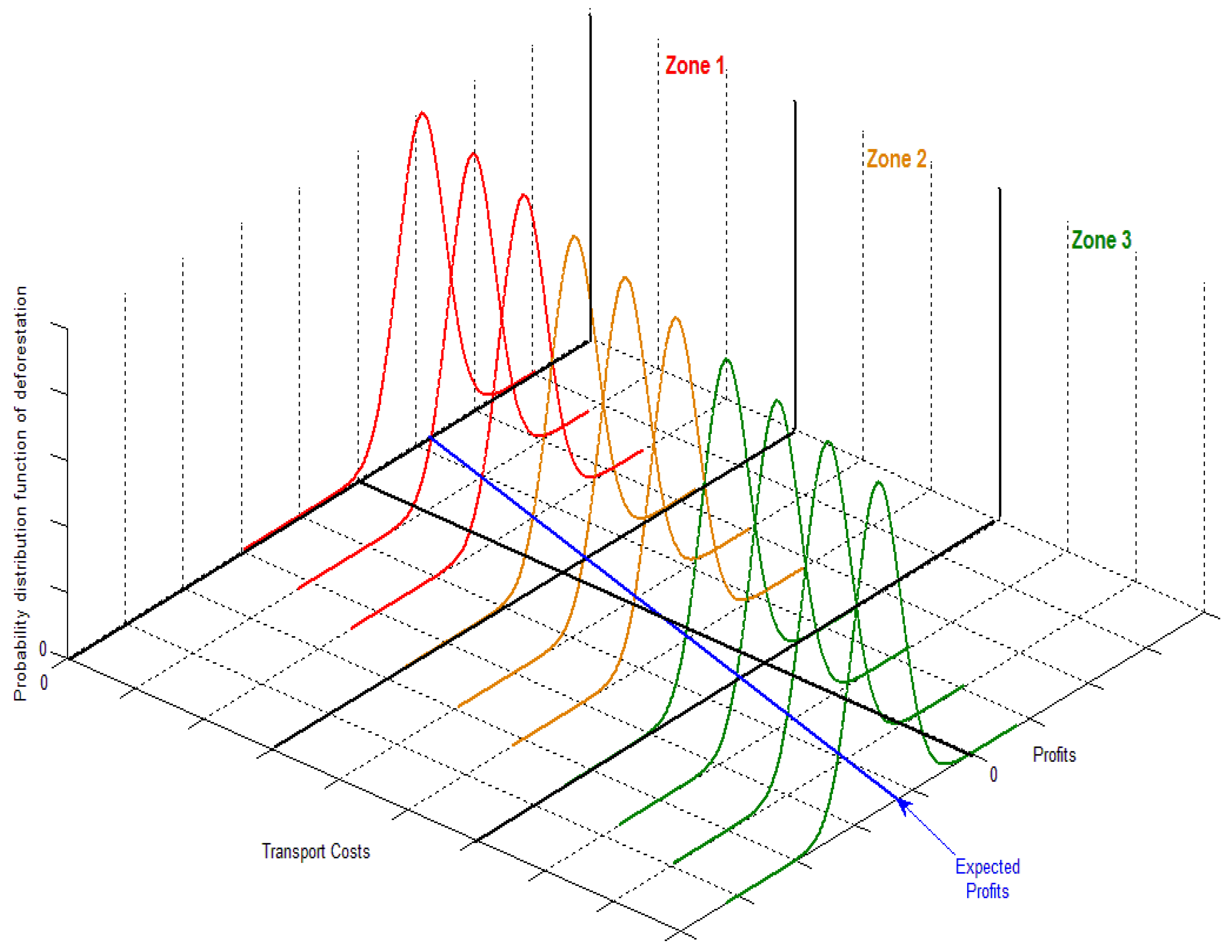
3.1. PA Impact by Location

From von Thunen [38] to the ‘monocentric model’, landscape analysts assert that the pressure to clear forest falls as we move outward from the market center (in Figure 1, a city where the axes cross). Transport costs imply falling profits from agricultural products to be sold in the city, as we move out. If all land is originally forested and only transport matters, forests will remain farther from markets (in Figure 1, forest will remain to the right of where the ‘Expected Profits’ line crosses the ‘0’axis).
Of course, factors other than transport also affect relative profits from agriculture versus forests: e.g., high slopes near markets may stay forested; and good soils far from market may be cleared. From an analyst’s point of view, some of these factors are observed while others are unobserved, as there are limits on all datasets. The empirical analyses we review include observable factors; however, Figure 1 does not explicitly depict the observables, focusing on representing unobserved factors in the form of a distribution, or varying density, of land-parcel profits around the Expected Profit line.
Conservation policies keep forests standing, using enforcement if there is pressure to clear forest. Without pressure, a fully forested PA does not imply impact, i.e., avoidance of baseline deforestation. Thus, if private pressure would not have led to clearing of the forest anyway, the policy did not have impact. More generally, a conservation policy’s impact equals the private or ‘baseline’ deforestation rate that would have arisen without the policy minus the deforestation rate observed with the policy. Within Figure 1, if transport cost is a significant factor in the private (or ‘baseline’) rate of clearing, then a PA that is far to the right may not have had much impact on the forest, even if fully forested.

3.2. PA Impact by Type

Given the underlying logic above, we can see that PA sites determine average PA impacts. Those sites will be affected by the political economy of development: PAs block production; thus, lobbying by producers tends to push PAs to low-profit locations. Where agricultural profit is high, lands are expensive to buy for conservation, plus lobbying against allocating public lands to conservation will be significant. Formally, a simple theory of PA location would be that for a PA to be established its cost—including local profit in Figure 1 that is foregone—must be below benefit (perceptions of which vary by decision maker, as World Bank [39] shows for Brazil). For any given level of PA benefit, this theory predicts that PA siting may avoid costs by avoiding pressures (as confirmed by, e.g., [5]).
The political economy can vary with the PA type, as well as by country and across time periods. Development tradeoffs for 'strict' PAs differ from those for mixed-use PAs that permit some local extraction and, therefore, induce less lobbying against the establishment of the PA. Thus, PA types can end up with different locations. For instance, if differences in PA regulations by type are actually enforced, we might well expect to see stricter PAs further to the right in Figure 1 [40,41].
Yet where public actors locate new PAs depends on whether they intend to enforce them. For instance, if locals believed that PAs in Mexico would not be enforced, i.e., expected the 1990s ‘paper parks’ outcome in [7], then they would have had little reason to lobby against a PA. Even strict PAs might be permitted near cities. Once PAs are sited, enforcement may occur but may fall with isolation [42,43]. Thus, interactions with pressure could produce varied patterns across space of PAs’ impacts.

4. Data and Matching Methods

4.1. Land Cover Data

Our data are from a global data set with land cover for 2000 [44] and land cover for 2005 (ESA) [45]. The 2000 data, GLC2000, have 23 classifications of land cover. They were reclassified to ‘natural’ or ‘human modified’, the latter including categories 16 (cultivated and managed areas), 17 (mosaic of cropland with tree cover or other natural vegetation), 18 (mosaics of cropland, with shrubs or grass cover), 19 (bare areas), and 22 (artificial surfaces and associated areas). The same was done for 2005 GLOBCOVER300 data. Again, multiple categories are placed into “natural” and “modified”, the latter including categories 11 (irrigated croplands), 14 (rainfed croplands), 20 (mosaic cropland (50%–70%)), 30 (mosaic cropland (20%–50%)), and 190 (urban areas >50%). These datasets were not constructed for precise intertemporal comparison, yet this transformation allows for a reasonable comparison of years. In each dataset, the spatial scale of land observations is 1-km2 polygons.
The change between the datasets—which we call ‘vegchange’—was calculated after that process. With the transformation, the data in principle track change from a ‘natural’ to a ‘human modified’ landscape and this 2000–2005 change is the dependent variable upon which we focus. We want to study recent changes that can be affected by the presence of PAs (though they are net changes, i.e., from ‘natural’ to ‘human modified’ and vice versa, which matters for indicators of species habitat). Given any issues with comparing datasets, we also analyze spatial patterns in the 2005 land cover.

4.2. Land Characteristics Data

Table 1 provides descriptive statistics for land characteristics in our analysis. Elevation (m) is from the Shuttle Radar Topography Mission [46], with slope in degrees from horizontal. The roads and urban areas used to compute distances (km) are from VMAP0 Roads of the World [47] and the Global Rural Urban Extent data [48]. While not the best quality, these VMAP0 data are all that is freely accessible to define the global road network.
PAs (protected areas) are from World Database on Protected Areas [49]. In these data, Categories I–II allow less human intervention, while Categories III–VI tend to be less protected, allowing for multiple uses. For any overlaps of categories, the polygon was categorized into the stricter category. We created three dummy variables: ‘protected’, for any protection (regardless of IUCN category); ‘mixed-use PA’ for IUCN categories III–VI; and ‘strict PA’, if the IUCN category is I or II. In order to check robustness, we also compared categories I–IV versus V–VI (following Joppa and Pfaff [3], as well as Nelson and Chomitz [40]). Also, for our time period, we used only the PAs created by 2000.
The World Wildlife Fund classified ecoregions [50]. Unclassified ecoregions were dropped (n = 1747) and we created dummy variables for the two ecoregions with the highest frequencies: ‘pineoakdum’ (10.7% of total) if the ecoregion is Sierra Madre Occidental Pine Oak Forest; and ‘chidesertdum’ (15.6% of total) if the ecoregion is Chihuahuan desert. The agricultural suitability is from International Institute for Applied Systems Analysis’ Global Agro-Ecological Zones data [51]. It uses climate, soil type, land cover, and slope to assign a value to each polygon, ranging from 0 (meaning no constraints) to 9 (severe constraints). We created two dummy variables: ‘low’ suitability for more agricultural constraints (i.e., agricultural suitability score of 8 or higher); and ‘high’ for situations with fewer agricultural constraints, (i.e., agricultural suitability score of 5 or lower). Additionally, as a robustness check, we use the full variable (which does not affect any of the results).
The fire variable, as a continuous metric, simply captures the number of fires from 2001 to 2006. The ‘firedum’ dummy we created takes a value of ‘1’ if that polygon experienced any fires (≥1). Finally, the distance-to-edge variable measures the distance to the edge of a protected area (km) from the polygon in question. A negative distance value indicates that the observation is inside of the PA.
These variables are not expected to fully explain land-cover change or the location of protection. Yet as all influence profit, they predict deforestation as well as the local resistance to protected areas. It is a combination of relevance to protection and deforestation that makes them useful for matching. The data contain approximately 1,935,301 observations (1-km2 polygons of land) and 13 variables. We have run many analyses with random 10% samples to confirm our results are robust to sampling. As noted, Table 1 presents summary statistics for all the aforementioned variables. For our results, we explore their impacts upon land-cover change as well as their significance for locations of PAs.

4.3. Matching Methods

If PAs were sited randomly, PA impacts would be easy to estimate using the differences between deforestation inside and outside of PAs. Deforestation outside would be an unbiased estimate of what would have been occurred inside PAs had there been no protection, as other factors would cancel out. Yet neither PAs in general, nor any PA type, seems to be distributed as if at random. Further, that non-randomness often appears to be along dimensions that can affect deforestation. To isolate PA impact by removing the influences of these differences, we use ‘matching’ methods to improve controls. One ‘matches’ each protected polygon with the most similar unprotected polygon(s) to get as close as possible to ‘apples-to-apples’ comparisons. Thus, PAs are compared not to all unprotected land but, instead, to the most similar unprotected land. Here, we apply propensity-score matching in our many initial analyses and then, for our final results, confirm robustness to covariate matching.
Propensity-score matching assesses the ‘similarity’ of sites using the predicted probability of a polygon being in a PA. PA polygons are then compared to unprotected polygons with similar enough characteristics to yield a similar probability of protection. Probabilities are generated by a probit model using factors in protection and deforestation to explain where protection occurred [52]. More weight is given, then, to the variables that are important determinants of protection. In covariate matching, similarity is assessed using the distance between polygons in the covariate space. For either method, we matched each treated polygon with the single most similar unprotected polygon.
However, selecting the most similar polygon does not guarantee that controls are, in fact, similar. Thus, we also check explicitly whether the selected unprotected polygons are similar to the protected. We examine balance, i.e., if the characteristics’ values are distinguishable between the protected and matched unprotected observations. Ideally, they should not be. Assuming large differences to begin with, we would expect at least a significant reduction in differences between groups, due to matching.
Given balanced characteristics, the deforestation in matched unprotected sites is an improved estimate of the deforestation that would have occurred at PA locations without the protection. PA impact is calculated as that counterfactual rate minus the observed deforestation (given protection). However, still there will be differences between these groups, in terms of characteristics relevant for deforestation. Thus, our preferred matching estimates involve first matching and then regressions. We refer to the latter as ‘bias adjustment’, as this addresses remaining differences in characteristics.
If the unobservable or omitted factors are correlated with “treatment”, i.e., with where PAs are, that could bias estimates of impact. Matching can control only for the included observable factors. For instance, we do not know anything about the populations in the PAs versus unprotected sites. We suspect that factors we do observe, however, such as the road and city distances, correlate with the unobservables. Thus, given our observables, we cannot be sure of the sign of any residual biases. As a robustness check, we compute ‘Rosenbaum bounds’ to estimate how sensitive are these results.

5. Results

5.1. Descriptive Statistics

Table 1 provides means for our outcomes variables as well as our metrics for drivers, including Mexico’s protection interventions—both in general and by PA type. Note that 79% of protection is a ‘mixed-use’ type, with an average IUCN category of 6, while 21% of the PA observations are stricter protection, having an average IUCN category of 1.3.
In terms of drivers of deforestation, Table 1 leads with a very important driver, urban distance. It is the driver that differs most in these data between PAs and unprotected polygons, and between the two types of PAs. Protected polygons are roughly three times as far as unprotected. Mixed-use PAs are roughly twice as far from cities as strict PAs—key for different PA impacts across types. We note that these relative locations of PA types in Mexico differ from the Brazilian Amazon [41] and from the averages across the globe (see Nelson and Chomitz [40] concerning PAs’ impacts on fires).
The relative location of PAs on average fits our political economy model in which, for a given societal benefit, opportunity costs drive PAs to relatively unprofitable sites. Table 1 shows this for urban distance and, to a lesser extent, for road distance, as well as for the fractions of high and low quality soils. Without considering such differences in location, Table 1’s last row provides a form of estimate of PAs’ average impact: there is a 2.9% loss of natural land cover in PAs, lower than the 9.2% loss for unprotected observations. Further, Table 1 suggests that there was actually some enforcement difference across stricter and mixed-use PAs during our time period (after alleged political shifts). The land-cover loss of 2.2% is lower for strict PAs, despite the fact that the only major difference in characteristics is that strict are closer to market (recall, siting occurred before our time period). However, actually estimating PA impact requires revisiting with control for all land characteristics.

5.2. Drivers of Protection

Table 2 uses regression to consider which locations are protected. Considering urban distance, PAs are further from urban areas even controlling for other influences. As expected from Table 1, the coefficient on urban distance for mixed-use PAs is larger than for strict, i.e., mixed-use are farther. For road distance, the smaller coefficients also support Table 1, i.e., the mixed-use PAs are closer (PAs may be near rural ejidos with road access, as 70% of land with forest is owned by ejidos, as Mexico’s 1992 Agrarian Law, Article 1 gave these communities legal status and land ownership and they can participate in conservation programs such as Mexico’s PES (The REDD Desk, 2012).) The other findings in Table 2, e.g., for agricultural suitability, also reflect the differences seen in Table 1.

5.3. Drivers of Land-Cover Change

Before estimating impacts of PAs on land cover, with controls for effects of other determinants, we would like to empirically confirm for our data what was driving the loss of natural land cover in Mexico in this time period. To do this, we examine rates of loss in just the unprotected locations. Table 3 presents OLS regressions of both land-cover loss and 2005 land cover on characteristics (note that we would expect the coefficients in these two outcomes columns to have the opposite signs).
In Table 3, as expected, urban distance has a significant effect on the profitability of land-cover loss. Also expected, road distance matters, even controlling for urban distance. Transport is critical. Higher elevation and slope also discourage whatever land uses involve the loss of natural cover, again as expected. Further, also expected, better conditions for agriculture increase the loss of cover. Both the Sierra Madre pine oak forest and the Chihuahuan desert are statistically significant controls.

5.4. Matching on Drivers of Land-Cover Change

Table 4 communicates whether our matching approach has actually made controls more similar. Again we start with the urban distance. For all PA polygons, or the strict and mixed-use subsets, Table 4 shows over 95% reductions in the differences between the PAs and unprotected controls. As the other differences noted in Table 1 were for road distance and high agricultural suitability, Table 4 shows similar reductions for them, as is the case for the significant and large ecoregions. These reductions in group differences are, we feel, a solid basis to claim improved estimates of PA impact.
That said, matching always leaves residual characteristics differences between treated and control, noting that we also tested matching ‘calipers’ of 0.01 and 0.001, yet that did not improve balances. Within Table 4, many differences are statistically significant, in part due to the very large sample (a reason we checked for robustness to random 10% samples (Supplemental Materials: Tables S1 and S2). Thus, the post-matching regressions that we have employed are well motivated in Table 4—but also we simply flag these residual differences (another reason we test robustness to covariate matching). Finally, we note that unobservable differences could also exist—always a key issue for matching.

5.5. Average PA Impact

For loss of natural land cover and the 2005 amount of land cover, Table 5 presents PAs’ impacts. The table’s first column presents average impact, i.e., the interventions are any kind of protection. We discuss here the 2000–2005 loss of natural land cover (as impacts upon 2005 cover are analogous).
Table 5’s first row shows means differences, analogous to the impact estimate implied by Table 1 (a little different because, as seen in Table 3’s first column, this outcome has fewer observations). Its second row introduces controls for the effects of other determinants of natural land-cover loss using regression analysis with all observations. This lower the estimated impact by almost half (as in Andam et al. [24] for Costa Rica and globally, for 141 countries, within Joppa and Pfaff [3]). The matching estimate in Table 5’s third row confirms robustness to matching’s use of observables, finding a 3.2% reduction in the 2000–2005 loss of land cover, using just the matched observations.

5.6. Impacts by PA Type

Table 5’s second and third columns separate the PA treatment into the strict versus mixed-use PAs. We note that enforcement choices are illuminated by simple differences in means, in the top row, where the loss rate in each PA type is compared to the loss rate within all unprotected polygons. Despite the fact that mixed-use PAs are further from cities, which should lower clearing pressures, more loss of natural land cover is occurring within mixed-use PAs. This simplest ‘impact estimate’ is lower for mixed-use PAs (6.1%) than for strict PAs (7.0%). Enforcement seems to occur on average and, it seems here, enforcement choices differed by PA type in that clearing differs across PA types.
The differences between Table 5’s first row and its second and third rows, which employ controls, in turn illuminate the different location choices for the two types of PAs. The more biased are PAs’ locations towards low pressure—as we predict given apparent enforcement on average for this time period (again, per Blackman et al. [7], such enforcement did not always occur)—the greater the reduction in estimated PA impact we should see when controlling for all the land characteristics.
When we control using observables, impact estimates for strict and mixed-use PAs both fall, consistent with the effect in the column for all of the PAs. The estimate for the mixed-use PAs falls by more, however, consistent with greater urban distance for mixed-use reducing the true impact, given the apparent impact. Given enforcement and locations, stricter PAs have greater impact (5.2% versus 2.7%, noting that this difference in estimated impacts across types is statistically significant). These results may be explained by siting in the ‘paper park’ era, before increases in enforcement.
These results are supported by our robustness checks making use of 10% samples, which also addresses potential issues with spatial autocorrelation. Further, calculation of Rosenbaum bounds, given that there could be important unobserved factors for which matching clearly cannot control, shows that to eliminate the significance of strict impacts requires unobserved factors to make non-PA sites almost three times as likely to be cleared–versus only twice as likely for impacts of all PAs.

6. Conclusions

With two goals in mind, we estimated a suite of PA impacts upon land-cover changes in Mexico. One motivation was to study a period after the 1990s, as conservation politics were alleged to have shifted and prior work had demonstrated that, during the 1990s, PAs functioned as ‘paper parks’. Another was to demonstrate the need to address how land-use decisions imply the possibility of bias in PA impact estimates and how the political economy of public PA choices implies its likelihood.
PAs did reduce losses of natural land cover within their boundaries during 2000–2005. Thus, it would appear that conservation politics shifted, at least as revealed by our impact assessment. Further, it was important in estimating the impacts to check for, and then control for, differences in characteristics of protected (versus unprotected) sites, as they directly influence deforestation. Controlling for them lowers the estimated average impact of PAs by about half. Further, controls generate different adjustments to the estimated impacts for the strict versus the mixed-use PAs.
Across PA types, a combination of siting and enforcement differences yielded different impacts, with strict PAs generating greater reductions in loss within their boundaries than mixed-use PAs. These results may reflect shifts over time in conservation politics, as PA locations seem consistent with a lack of intention to enforce during the 1990s that, as our results suggest, later was reversed.
Extensions could improve on these analyses. Our data for land cover are not ideal and Mexico’s new MRV mechanism may offer options. For moving forward to future analyses, e.g., INEGI has invested in data on roads and vegetation, for example, and the Nature Conservancy has invested in tracking sites and types of protection. Finally, more study of differences in dynamics across space could further contribute to an understanding of the conditions that drive the impacts of protection.

Supplementary Materials

The following are available online at www.mdpi.com/1999-4907/8/1/17/s1, Table S1: Rosenbaum Bounds, Table S2: 10% Samples.

Acknowledgments

We are grateful for helpful suggestions from Maria Carnovale and Elizabeth Shapiro. This paper derives from Francisco J. Santiago-Ávila’s master’s project (or MP) at Duke University, concluded in 2013.

Author Contributions

Alexander Pfaff conceived of the paper; all the authors designed analyses; Lucas Joppa organized most of the data; Francisco J. Santiago-Ávila performed the analyses with guidance from Alexander Pfaff and Lucas Joppa; and all of the authors wrote the paper.

Conflicts of Interest

The authors declare no conflict of interest.

References

  1. Pfaff, A.; Amacher, G.S.; Sills, E.O. Realistic REDD: Improving the forest impacts of domestic policies in different settings. Rev. Envir. Eco. Policy 2013, 7, 114–135. [Google Scholar] [CrossRef]
  2. Joppa, L.; Pfaff, A. Re-assessing the forest impacts of protection: The challenge of non-random protection & a corrective method. Annal. NY Acad. Sci 2010, 1185, 135–149. [Google Scholar]
  3. Joppa, L.; Pfaff, A. Global Park Impacts. Proc. Royal Society B. 2010. [Google Scholar] [CrossRef]
  4. Pfaff, A.; Robalino, J.A.; Sanchez-Azofeifa, G.A.; Andam, K.; Ferraro, P. Park Location Affects Forest Protection: Land Characteristics Cause Differences in Park Impacts across Costa Rica. BE J. Econ. Anal. Poli. 2009. Available online: http://www.bepress.com/bejeap/vol9/iss2/art5 (accessed on 24 December 2016).
  5. Joppa, L.; Pfaff, A. High & Far: Biases in the location of protected areas. PLoS ONE 2009, 4, e8273. [Google Scholar] [CrossRef]
  6. Pfaff, A.; Robalino, J. Protecting Forests, Biodiversity and the Climate: Predicting policy impact to improve policy choice. Oxford Rev. Econ. Policy 2012, 28, 164–179. [Google Scholar] [CrossRef]
  7. Blackman, A.; Pfaff, A.; Robalino, J. Paper Park Performance: Mexico’s natural protected areas in the 1990s. Glob. Environ. Chang. 2015, 31, 50–61. [Google Scholar] [CrossRef]
  8. Johnson, T.; Alatorre, C.; Romo, Z.; Feng, L. Low-Carbon Development for Mexico; The World Bank: Washington, DC, USA, 2010. [Google Scholar]
  9. The REDD Desk. REDD in Mexico. 2011. Available online: www.theredddesk.org/countries/mexico/readiness_overview (accessed on 3 February 2013).
  10. The Forest Carbon Partnership. REDD Readiness Progress Fact Sheet. 2012. Available online: www.forestcarbonpartnership.org/ (accessed on 3 February 2013).
  11. Naughton-Treves, L.; Holland, M.B.; Brandon, K. The role of protected areas in conserving biodiversity and sustaining local livelihoods. Annual Rev. Environ. Resour. 2005, 30, 219–252. [Google Scholar] [CrossRef]
  12. Nagendra, H. Do Parks Work? Impact of Protected Areas on Land Cover Clearing. Ambio 2008, 37, 330–337. [Google Scholar] [CrossRef] [PubMed]
  13. Campbell, A.; Clark, S.; Coad, L.; Miles, L.; Bolt, K.; Roe, D. Protecting the future: Carbon, forests, protected areas and local livelihoods. Biodiversity 2008, 9, 117–122. [Google Scholar] [CrossRef]
  14. Fuller, D.; Jessup, T.; Salim, A. Loss of forest cover in Kalimantan, Indonesia, since the 1997–1998 El Nino. Conserv. Biol. 2004, 18, 249–254. [Google Scholar] [CrossRef]
  15. Sanchez-Azofeifa, G.A.; Quesada-Mateo, C.; Gonzalez-Quesada, P.; Dayanandan, S.; Bawa, K.S. Protected areas and conservation of biodiversity in the tropics. Conserv. Biol. 1999, 13, 407–411. [Google Scholar] [CrossRef]
  16. DeFries, R.; Hansen, A.; Newton, A.C.; Hansen, M.C. Increasing isolation of protected areas in tropical forests over the past twenty years. Ecol. Appl. 2005, 15, 19–26. [Google Scholar] [CrossRef]
  17. Gaveau, D.L.A.; Wandono, H.; Setiabudi, F. Three decades of deforestation in southwest Sumatra: Have protected areas halted forest loss and logging, and promoted re-growth? Biol. Conserv. 2007, 134, 495–504. [Google Scholar] [CrossRef]
  18. Messina, J.P.; Walsh, S.J.; Mena, C.F.; Delamater, P.L. Land tenure and deforestation patterns in the Ecuadorian Amazon: Conflicts in land conservation in frontier settings. Appl. Geogra. 2006, 26, 113–128. [Google Scholar] [CrossRef]
  19. Bruner, A.; Gullison, R.E.; Rice, R.E.; Da Fonseca, G.A. Effectiveness of parks in protecting tropical biodiversity. Science 2001, 291, 125–128. [Google Scholar] [CrossRef] [PubMed]
  20. Curran, L.; Trigg, S.N.; McDonald, A.K.; Astiani, D.; Hardiono, Y.M.; Siregar, P.; Caniago, I.; Kasischke, E. Lowland forest loss in protected areas of Indonesian Borneo. Science 2004, 303, 1000–1003. [Google Scholar] [CrossRef] [PubMed]
  21. Kinnaird, M.F.; Sanderson, E.W.; O'Brien, T.G.; Wibisono, H.T.; Woolmer, G. Deforestation trends in a tropical landscape and implications for endangered large mammals. Conserv. Biol. 2003, 17, 245–257. [Google Scholar] [CrossRef]
  22. Liu, J.G.; Linderman, M.; Ouyang, Z.; An, L.; Yang, J.; Zhang, H. Ecological degradation in protected areas: The case of Wolong Nature Reserve for giant pandas. Science 2001, 292, 98–101. [Google Scholar] [CrossRef] [PubMed]
  23. Sader, S.; Hayes, D.J.; Hepinstall, J.A.; Coan, M.; Soza, C. Forest change monitoring of a remote biosphere reserve. Int. J. Remote Sens. 2001, 22, 1937–1950. [Google Scholar] [CrossRef]
  24. Andam, K.; Ferraro, P.J.; Pfaff, A.; Sanchez-Azofeifa, G.A.; Robalino, J.A. Measuring the effectiveness of protected area networks in reducing deforestation. Proc. Natl. Acad. Sci. USA 2008, 105, 16089–16094. [Google Scholar] [CrossRef] [PubMed]
  25. Shah, P.; Baylis, K. Evaluating Heterogeneous Conservation Effects of Forest Protection in Indonesia. PLoS ONE 2015, 10, e0124872. [Google Scholar] [CrossRef] [PubMed]
  26. Munoz-Pina, C.; Guevara, A.; Torres, J.M.; Brana, J. Paying for the hydrological services of Mexico’s forests: Analysis, negotiations and results. Ecol. Econ. 2008, 65, 725–736. [Google Scholar] [CrossRef]
  27. Alix-Garcia, J.M.; Shapiro, E.N.; Sims, K.R.E. Forest Conservation and Slippage: Evidence from Mexico’s National Payments for Ecosystem Services Program. Land Econ. 2012, 88, 613–638. [Google Scholar] [CrossRef]
  28. Alix-Garcia, J.M.; Sims, K.R.E.; Yanez-Pagans, P. Only One Tree from Each Seed? Environmental effectiveness and poverty alleviation in Mexico’s Payments for Ecosystem Services Program. Am. Econ. J. Econ. Policy 2015, 7, 1–40. [Google Scholar] [CrossRef]
  29. Rodriguez, L.A. On the Regulation of Small Actors: Three Experimental Essays about Policies based on Voluntary Compliance and Decentralized Monitoring. Ph.D. Thesis, Duke University, Durham, NC, USA, 2016. [Google Scholar]
  30. Kaczan, D.; Pfaff, A.; Rodriguez, L.; Shapiro, E.N. Increasing the Impact of Collective Incentives: Conditionality on additionality within PES in Mexico. Unpublished work. 2016. [Google Scholar]
  31. Sims, K.R.E.; Alix-Garcia, J.M. Parks versus PES: Evaluating direct and incentive-based land conservation in Mexico. J. Environ. Econ. Manag. 2016. [Google Scholar] [CrossRef]
  32. Figueroa, F.; Sánchez-Cordero, V. Effectiveness of Natural Protected Areas to Prevent Land Use and Land Cover Change in Mexico. Biodivers. Cons. 2008, 17, 3223–3240. [Google Scholar] [CrossRef]
  33. Mas, J.F. Assessing Protected Areas Effectiveness Using Surrounding (Buffer) Areas Environmentally Similar to the Target Area. Envir. Monit. Assess. 2005, 105, 69–80. [Google Scholar] [CrossRef]
  34. Durán, E.; Mas, J.F.; Velázquez, A. Land Use/Cover Change in Community-Based Forest Management Regions and Protected Areas in Mexico. In The Community Forests of Mexico; Bray, D.B., Merino-Pérez, L., Barry, D., Eds.; University of Texas Press: Austin, TX, USA, 2005; pp. 215–238. [Google Scholar]
  35. Honey-Roses, J.; Lopez-Garcia, J.; Rendon-Salinas, E.; Peralta-Higuera, A.; Galindo-Leal, C. To pay or not to pay? Monitoring performance and enforcing conditionality when paying for forest conservation in Mexico. Environ. Conserv. 2009, 36, 120–128. [Google Scholar] [CrossRef]
  36. Honey-Roses, J.; Baylis, K.; Ramirez, M.I. A Spatially Explicit Estimate of Avoided Forest Loss. Conserv. Biol. 2011, 25, 1032–1043. [Google Scholar] [CrossRef] [PubMed]
  37. Miteva, D.; Ellis, E.; Ellis, P.; Griscom, B. The role of property rights in resisting forest loss in the Yucatan Peninsula. Unpublished work. 2016. [Google Scholar]
  38. Von Thünen, J.H. Der Isolierte Staat in Beziehung der Landwirtschaft und Nationalökonomie (1996, trans.). In von Thünen’s The Isolated State; Hall, P., Ed.; Pergamon Press: Oxford, United Kingdom, 1826. [Google Scholar]
  39. World Bank. Policies and Deforestation in the Brazilian Amazon: Roads, Protected Areas, Their Interactions, and Their Impacts; Technical Paper; World Bank: Washington DC, USA, 2013. [Google Scholar]
  40. Nelson, A.; Chomitz, K. Effectiveness of Strict vs. Multiple Use Protected Areas in Reducing Tropical Forest Fires: A Global Analysis Using Matching Methods. PLoS ONE 2011, 6, 322722. [Google Scholar] [CrossRef] [PubMed]
  41. Pfaff, A.; Robalino, J.; Lima, E.; Sandoval, C.; Herrera, L.D. Governance, Location and Avoided Deforestation from Protected Areas: Greater restrictions can have lower impact, due to differences in location. World Develop. 2014. Available online: http://dx.doi.org/10.1016/j.worlddev.2013.01.011 (accessed on 24 December 2016).
  42. Albers, H.J. Spatial modeling of extraction and enforcement in developing country protected areas. Resour. Energy Econ. 2010, 32, 165–179. [Google Scholar] [CrossRef]
  43. Borner, J.; Kis-Katos, K.; Hargrave, J.; Konig, K. Post-Crackdown Effectiveness of Field-Based Forest Law Enforcement in the Brazilian Amazon. PLoS ONE 2015, 10, e0121544. [Google Scholar] [CrossRef] [PubMed]
  44. Bartholome, E.; Belward, A. GLC2000: A new approach to global land cover mapping from Earth observation data. Int. J. Remote Sens. 2005, 26, 1959–1977. [Google Scholar] [CrossRef]
  45. European Space Agency (ESA); ESA GlobeCover Project lead by MEDIAS-France. Ionia GlobCover. Available online: http://due.esrin.esa.int/page_globcover.php (accessed on 24 December 2009).
  46. United States Geological Survey. Shuttle Radar Topography Mission, 30 Arc Second scene SRTM_GTOPO_u30, Mosaic. 2006. Available online: http://www2.jpl.nasa.gov/srtm/ (accessed on 24 December 2008). [Google Scholar]
  47. National Imagery and Mapping Agency (NIMA). Vector Map Level. Available online: http://egsc.usgs.gov/nimamaps/ (accessed on 24 December 2010).
  48. United Nations Environment Program-Center for International Earth Science Information Network (UNEP-CIESEN). Global Rural-Urban Mapping Project (GRUMP), Alpha Version: Urban Extent. 2006. Available online: http://sedac.ciesin.columbia.edu/gpw/ancillaryfigures.jsp (accessed on 24 December 2010).
  49. World Conservation Monitoring Center. World Database on Protected Areas (WDPA). World Conservation Union (IUCN) and UNEP-World Conservation Monitoring Center Cambridge, UK. 2007. Available online: http://www.wdpa.org/ (accessed on 24 December 2010).
  50. Olson, D.; Dinerstein, E.; Wikramanayake, E.D.; Burgess, N.D.; Powell, G.V.; Underwood, E.C.; D’Amico, J.A.; Itoua, I.; Strand, H.E.; Morrison, J.C.; et al. Terrestrial ecoregions of the world: A new map of life on Earth. BioScience 2001, 51, 933–938. [Google Scholar] [CrossRef]
  51. Fischer, G.; van Velthuizen, H.; Nachtergaele, F.; Medow, S. Global Agro-Ecological Zones. 2002. Available online: http://www.fao.org/nr/gaez/en/ (accessed on 24 December 2010).
  52. Rosenbaum, P.R.; Rubin, D.B. The central role of the propensity score in observational studies for causal effects. Biometrika 1983, 70, 41–55. [Google Scholar] [CrossRef]
Figure 1. Expected Profits Across Landscape with Implications for PA Impact & Siting.
Forests 08 00017 g001
Table 1. Land characteristics and land cover (including PA type).
UnprotectedProtectedProtected–StricterProtected–Mixed-Use
Protected, Stricter Subset (1/0)00.2110
Protected, Mixed-use Subset (1/0)00.7901
IUCN Category (1–6)05.01.36.0
Distance Outside PA Edge (km)55.8−14.0−10.5−15.0
Urban Distance (km)35.695.758.4105.3
Road Distance (km)8.512.614.312.2
Elevation (m)1081622885554
Slope (degrees)2.812.853.422.70
Agricultural Suitability (0–9)6.176.816.576.88
Relatively Low Agric. Suitability (1/0)0.390.560.380.60
Relatively High Agric. Suitability (1/0)0.370.210.220.21
Fires (number detected in 2000–2006)0.0050.0030.0040.003
Dummy for Whether Any Fires (1/0)0.0050.0030.0040.003
Pine Oak Forest Dummy (1/0)0.1150.0030.0050.003
Chihuahua Desert Dummy (1/0)0.1630.0640.0120.078
GLC 2000 Natural Land Cover (1/0)0.8400.9200.9120.921
Globcover 2005 Natural Land Cover (1/0)0.8620.9570.9700.954
2000–2005 Loss of Natural Cover (1/0)0.0920.0290.0220.031
# observations1,801,935121,84725,09696,751
Table 2. Drivers of protection (including by type).
ProtectedProtected–Stricter SubsetProtected–Mixed-Use Subset
Urban Distance0.00251 ***0.00032 ***0.00248 ***
(0.000)(0.000)(0.000)
Road Distance0.00031 *0.00066 ***−0.00035 ***
(0.000)(0.000)(0.000)
Elevation−0.00001 ***0.00000 ***−0.00001 ***
(0.000)(0.000)(0.000)
Slope0.00120 ***0.00048 ***−0.00044 ***
(0.000)(0.000)(0.000)
High Agricultural Suitability−0.01533 ***−0.01053 ***−0.00564 ***
(0.000)(0.000)(0.000)
Pine Oak Forest−0.10585 ***−0.03090 ***−0.08272 ***
(0.000)(0.000)(0.000)
Chihuahuan Desert−0.10554 ***−0.03271 ***−0.08405 ***
(0.000)(0.000)(0.000)
constant−0.00390 ***−0.00566 ***0.00461 ***
(0.000)(0.000)(0.000)
# obs1,923,7821,827,0311,898,686
R20.1820.0210.196
Adjusted R20.1820.0210.196
Robust standard errors in parentheses: *** p < 0.001; ** p < 0.01; * p < 0.05.
Table 3. Drivers of natural land cover, explaining both loss & final amount (outside PAs).
Natural Land Cover Loss 2000–2005Natural Land Cover
Amount 2005
Urban Distance−0.00101 ***0.00137 ***
(0.000)(0.000)
Road Distance−0.00074 ***0.00064 ***
(0.000)(0.000)
Elevation−0.00004 ***0.00006 ***
(0.000)(0.000)
Slope−0.00445 ***0.00572 ***
(0.000)(0.000)
High Agricultural Suitability0.03979 ***−0.06338 ***
(0.001)(0.001)
Pine Oak Forest0.06457 ***−0.06964 ***
(0.001)(0.001)
Chihuahuan Desert−0.02074 ***0.01979 ***
(0.001)(0.001)
Constant0.19813 ***0.75283 ***
(0.001)(0.001)
# obs1,514,2491,801,935
R20.030.06
Adjusted R20.030.06
Robust standard errors in parentheses: *** p < 0.001, ** p < 0.01, * p < 0.05.
Table 4. Matching balance.
Propensity Score MatchingProtected–Unprotected Characteristics DifferencesProtected–Stricter SubsetProtected–Mixed-Use Subset
Urban Distance
Pre-match difference60.064 ***19.273 ***69.409 ***
Post-match difference−2.580 ***−0.817−2.759 ***
% residual difference−4.3%−4.2%−4.0%
Road Distance
Pre-match difference4.128 ***5.584 ***3.622 ***
Post-match difference0.223 ***0.174−0.029
% residual difference5.4%3.1%−0.8%
Elevation
Pre-match difference−459.298 ***−169.814 ***−524.714 ***
Post-match difference−126.659 ***26.358 **−61.156 ***
% residual difference27.6%−15.5%11.7%
Slope
Pre-match difference0.039 ***0.617 ***−0.118 ***
Post-match difference−0.684 ***−0.133 **−0.003
% residual difference−21.6%2.5%
High Agric. Suitability
Pre-match difference−0.163 ***−0.139 ***−0.165 ***
Post-match difference−0.049 ***0.013 **−0.002
% residual difference30%−9.4%1.2%
Pine Oak Forest
Pre-match difference−0.111 ***−0.105 ***−0.110 ***
Post-match difference−0.007 ***−0.002 **−0.005 ***
% residual difference6.3%1.9%4.5%
Chihuahuan Desert
Pre-match difference−0.099 ***−0.147 ***−0.084 ***
Post-match difference−0.021 ***−0.001−0.025 ***
% residual difference21.2%0.7%29.8%
† increased small difference; *** p < 0.001; ** p < 0.01; * p < 0.05.
Table 5. PA impact estimates.
ProtectedProtected–Strict SubsetProtected–Mixed-Use Subset
2000–2005 Natural Land Cover Loss
Pre-match difference in means–6.3 % ***–7.0 % ***–6.1%***
# observations1,923,7821,827,0311,898,686
Pre-match regression (all the data)–3.5 % ***–5.8 % ***–2.6 % ***
SE(0.001)(0.001)(0.001)
# observations1,626,2951,537,1391,603,405
Post-match regression (most similar)–3.2 % ***–5.2 % ***–2.7 % ***
SE(0.002)(0.003)(0.001)
# observations181,84438,633143,318
2005 Natural Land Cover
Pre-match difference in means9.5 % ***10.8 % ***9.2 % ***
# observations1,923,7821,827,0311,898,686
Pre-match regression (all the data)3.7 % ***6.8 % ***2.5 % ***
SE(0.001)(0.001)(0.001)
# observations1,923,7821,827,0311,898,686
Post-match regression (most similar)3.5 % ***6.3 % ***2.9 % ***
SE(0.002)(0.003)(0.001)
# observations201,56943,655157,826
*** p < 0.001, ** p < 0.01, * p < 0.05.

